Embed Size (px)
Citation preview
Summary of La Gonave, Haiti - Geology and Hydrogeology
James K. Adamson, PG
August 22, 2013
1 Summary
The island of La Gonave is approximately 750 square kilometers in size and located o↵ thecoast of mainland Haiti. Approximately 115,000 people inhabit the island, about half ofthe island population resides in the towns of Anse-a-Galets and Pointe-a-Racquette. Theremainder of the island is rural with small isolated communities.
Annual precipitation is estimated between 700 and 1,200 mm/year, with significantlyhigher precipitation on the eastern portion of the island. The dry season on La Gonavetypically occurs from late October through April. La Gonave has little perennial surfacewater with the exception of several springs. In the eastern portion of the island, manysprings are present due to stratigraphic and structural factors. The western portion of theisland has no inland springs, but many coastal karst springs that often produce brackishwater. A primary reason for the water scarcity on the western portion of the island is dueto the thick Pliocene and Pleistocene-aged coral limestones, which infiltrate a majority ofprecipitation.
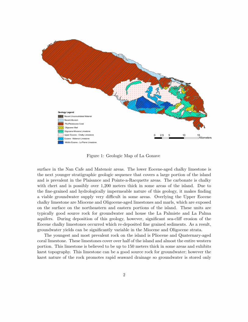
Figure 1 is a geologic map of La Gonave that was developed though the compilationof the work of many geologic investigators over the past century that have contributedto published or publicly available information. Some of these investigators include: J.Adamson, R. Bien, D. Boisson, J. Butterlin, S. Dykstra, A. Momplaisir, H. Spruijt and J.Troester.
The island is a complex northwest trending regional anticlinal feature, which exposes acore of middle Eocene-aged limestone in the southeastern portion of the island. This unit isthe oldest rock found on La Gonave and blankets the highest portion of the island reachingan elevation of approximately 780 meters. This limestone is believed to exist beneath theentire island at variable depths; it is also the source rock for what is believed to be thelargest aquifer of the island. This aquifer is referred to as the Chien Content Aquifer,named after the highest mountain on the island where the limestone is best exposed. Thisaquifer is only a proven resource on the eastern portion of the island, its presence in westernLa Gonave has not been verified scientifically.
Overlying the middle Eocene limestones are younger Eocene massive limestones thatare less prominent, referred to as the Matenoir complex. These are only observed at the
1
")
")
") ") ")
")") ")
")
")")
")")")
")
")
")") ") ") ")
")")
")
")
")
")
")") ")
")")
")
")")
")")
")
") ")") ")
")
")
")
")")")
")")
")
")
")")
")")
")
")
")")")
")
")
")
")")")
")")
")
")
")
")")
")")
")
")")
")
")
")
")
")
")")
")
")")
")
")
")")
")
")
")")
")
")
")
")
")
")
")
")
9
87 6
543
2
1
45
99
98
97
9695
94
93
9291
90
89
88
87
85
84
83
82
8180
79
78 77
76
75
74
73
72
71
70
69
6867
66
65
64
6361
60
59
5756
55
54
53
52
5150
4948
47
46
44
43
4241
4039
38
37
36
35 34
33
32
31
3029
28
27
26
25
24
23
22
2120
1918
17
16
15
14 13
12
11
10
107
106
105
104
103
102
101
100
Possible Drilling LocationsGeo Understanding Level
") 1 - 2
") 3 - 4
") 5
") 6 - 7
") 8 - 10
Borings- Haiti OutreachWater Condition
!A Bon/Good
!A Seche/Dry
Surface Water Divide Line
Modeled Flow Paths
Springs (Spruijt)Water Quality (Conductivity)
XW 0 - 800
XW 801 - 1500
XW 1501 - 1800
XW 1801 - 4200
XW 4201 - 7500
XW 7501 - 17500
XW 17501 - 33000
Water Quality Data - Wells and SpringsTotal Dissolved Solids
_̂ 220 - 400 TDS
_̂ 401 - 800 TDS
_̂ 801 - 1200 TDS
_̂ 1201 - 2000 TDS
_̂ 2001 - 7000 TDS
La Gonave Geology
WWWWWWWWWWWWWWWWWWWWWWWWWWWWWWWWWWWWWWWWRecent Unconsolidated Material
( ( ( ( ( (( ( ( ( ( (( ( ( ( ( (
Recent Alluvium
Plio/Pleistocene Coral
Oligocene Marl
! ! ! ! ! ! ! !
! ! ! ! ! ! ! !
! ! ! ! ! ! ! !
! ! ! ! ! ! ! !
Oligocene-Miocene Limestone
! ! ! !
! ! ! ! Upper Eocene - Chalky Limestone
Eocene - Matenoir Limestone
Middle Eocene - La Pierre Limestone
0 4 8 122Kilometers
( (( (
( (( (( (
( ( (( ( (( ( (
( ( (( ( (
( ( ( (( ( ( (( ( ( (
( ( ( ( ( ( ( ( ( ( ( (( ( ( ( ( ( ( ( ( ( ( (( ( ( ( ( ( ( ( ( ( ( (( ( ( ( ( ( ( ( ( ( ( (( ( ( ( ( ( ( ( ( ( ( (( ( ( ( ( ( ( ( ( ( ( (( ( ( ( ( ( ( ( ( ( ( (( ( ( ( ( ( ( ( ( ( ( (( ( ( ( ( ( ( ( ( ( ( (( ( ( ( ( ( ( ( ( ( ( (( ( ( ( ( ( ( ( ( ( ( (
( (( (
( (( (( (( (
( (( (( (
( ( ( ( ( ( ( ( ( ( ( ( (( ( ( ( ( ( ( ( ( ( ( ( (( ( ( ( ( ( ( ( ( ( ( ( (( ( ( ( ( ( ( ( ( ( ( ( (( ( ( ( ( ( ( ( ( ( ( ( (( ( ( ( ( ( ( ( ( ( ( ( (
( ( (( ( (( ( (
( ( ( ( ( ( ( ( ( ( ( ( ( ( ( ( ( ( ( ( ( ( ( ( ( ( ( ( ( ( ( ( ( ( ( ( ( ( (( ( ( ( ( ( ( ( ( ( ( ( ( ( ( ( ( ( ( ( ( ( ( ( ( ( ( ( ( ( ( ( ( ( ( ( ( ( (( ( ( ( ( ( ( ( ( ( ( ( ( ( ( ( ( ( ( ( ( ( ( ( ( ( ( ( ( ( ( ( ( ( ( ( ( ( (( ( ( ( ( ( ( ( ( ( ( ( ( ( ( ( ( ( ( ( ( ( ( ( ( ( ( ( ( ( ( ( ( ( ( ( ( ( (( ( ( ( ( ( ( ( ( ( ( ( ( ( ( ( ( ( ( ( ( ( ( ( ( ( ( ( ( ( ( ( ( ( ( ( ( ( (( ( ( ( ( ( ( ( ( ( ( ( ( ( ( ( ( ( ( ( ( ( ( ( ( ( ( ( ( ( ( ( ( ( ( ( ( ( (( ( ( ( ( ( ( ( ( ( ( ( ( ( ( ( ( ( ( ( ( ( ( ( ( ( ( ( ( ( ( ( ( ( ( ( ( ( (( ( ( ( ( ( ( ( ( ( ( ( ( ( ( ( ( ( ( ( ( ( ( ( ( ( ( ( ( ( ( ( ( ( ( ( ( ( (( ( ( ( ( ( ( ( ( ( ( ( ( ( ( ( ( ( ( ( ( ( ( ( ( ( ( ( ( ( ( ( ( ( ( ( ( ( (( ( ( ( ( ( ( ( ( ( ( ( ( ( ( ( ( ( ( ( ( ( ( ( ( ( ( ( ( ( ( ( ( ( ( ( ( ( (( ( ( ( ( ( ( ( ( ( ( ( ( ( ( ( ( ( ( ( ( ( ( ( ( ( ( ( ( ( ( ( ( ( ( ( ( ( (( ( ( ( ( ( ( ( ( ( ( ( ( ( ( ( ( ( ( ( ( ( ( ( ( ( ( ( ( ( ( ( ( ( ( ( ( ( (( ( ( ( ( ( ( ( ( ( ( ( ( ( ( ( ( ( ( ( ( ( ( ( ( ( ( ( ( ( ( ( ( ( ( ( ( ( (( ( ( ( ( ( ( ( ( ( ( ( ( ( ( ( ( ( ( ( ( ( ( ( ( ( ( ( ( ( ( ( ( ( ( ( ( ( (( ( ( ( ( ( ( ( ( ( ( ( ( ( ( ( ( ( ( ( ( ( ( ( ( ( ( ( ( ( ( ( ( ( ( ( ( ( (( ( ( ( ( ( ( ( ( ( ( ( ( ( ( ( ( ( ( ( ( ( ( ( ( ( ( ( ( ( ( ( ( ( ( ( ( ( (( ( ( ( ( ( ( ( ( ( ( ( ( ( ( ( ( ( ( ( ( ( ( ( ( ( ( ( ( ( ( ( ( ( ( ( ( ( (( ( ( ( ( ( ( ( ( ( ( ( ( ( ( ( ( ( ( ( ( ( ( ( ( ( ( ( ( ( ( ( ( ( ( ( ( ( (( ( ( ( ( ( ( ( ( ( ( ( ( ( ( ( ( ( ( ( ( ( ( ( ( ( ( ( ( ( ( ( ( ( ( ( ( ( (( ( ( ( ( ( ( ( ( ( ( ( ( ( ( ( ( ( ( ( ( ( ( ( ( ( ( ( ( ( ( ( ( ( ( ( ( ( (( ( ( ( ( ( ( ( ( ( ( ( ( ( ( ( ( ( ( ( ( ( ( ( ( ( ( ( ( ( ( ( ( ( ( ( ( ( (
WWWWWWWWWWWWWWWWWWWWWWWWWWWWWWWWWWWW
WWWWWWWWWWWWWWWWWWWWWWWWWWWWWWWWWWWWWWWWWWWWWWWWWWWWWWWWWWWWWWWWWWWWWWWWWWWWWWWWWWWWWWWWWWWWWWWWWWWWWWWWWWWWWWWWWWWWWWWWWWWWWWWWWWWWWWWWWWWWWWWWWWWWWWWWWWWWWWWWWWWWWWWWWWWWWWWWWWWW
WWWWWWWWWWWWWWWWWWWW
WWWWWWWWWWWWWWWWWWWWWW
WWWWWWWWW
WWWWWWWWWWWWWWWWWWWW
WWWWWWWWWWWWWWWWWWWWWWWWWWWWWWWWWWWWWWWWWWWWWWWWWWWWW
WWWWWWWWWWWW
WWWWWWWWWWWWWWWWWWWWWWWWWWWWWWWWWWWWWWWWWWWWWWWWWW
WWWWWWWWWWWWWWWWWWWWWWWWWWWWWWWW
WWWWWWWWWWWWWWW
WWWWWWWWWW
WWWWWWWWWWWWWWWWWWWWWWWWWWWW! ! !
! ! !
! ! !
! ! !
! ! !
! ! !
! ! !
! !
!
!
! ! ! ! ! ! ! !
! ! ! ! ! ! ! !
! ! ! ! ! ! ! !
! ! ! ! ! ! ! !
! ! ! ! ! ! ! !
! ! ! ! ! ! ! !
! !
! !
! ! ! ! !
! ! ! ! !
! ! ! ! !
! ! ! !
! ! ! !
! ! ! !
! !
! !
! !
! !
!
!
!
!
! !
! !
! ! ! ! !
! ! ! ! !
! ! ! ! !
! ! ! ! !
! ! ! ! !
! ! !
! ! !! ! ! ! ! ! ! ! ! ! ! ! ! ! ! ! ! ! ! ! ! ! ! ! ! ! ! ! ! ! ! ! ! ! ! ! !
! ! ! ! ! ! ! ! ! ! ! ! ! ! ! ! ! ! ! ! ! ! ! ! ! ! ! ! ! ! ! ! ! ! ! ! !
! ! ! ! ! ! ! ! ! ! ! ! ! ! ! ! ! ! ! ! ! ! ! ! ! ! ! ! ! ! ! ! ! ! ! ! !
! ! ! ! ! ! ! ! ! ! ! ! ! ! ! ! ! ! ! ! ! ! ! ! ! ! ! ! ! ! ! ! ! ! ! ! !
! ! ! ! ! ! ! ! ! ! ! ! ! ! ! ! ! ! ! ! ! ! ! ! ! ! ! ! ! ! ! ! ! ! ! ! !
! ! ! ! ! ! ! ! ! ! ! ! ! ! ! ! ! ! ! ! ! ! ! ! ! ! ! ! ! ! ! ! ! ! ! ! !
! ! ! ! ! ! ! ! ! ! ! ! ! ! ! ! ! ! ! ! ! ! ! ! ! ! ! ! ! ! ! ! ! ! ! ! !
! ! ! ! ! ! ! ! ! ! ! ! ! ! ! ! ! ! ! ! ! ! ! ! ! ! ! ! ! ! ! ! ! ! ! ! !
! ! ! ! ! ! ! ! ! ! ! ! ! ! ! ! ! ! ! ! ! ! ! ! ! ! ! ! ! ! ! ! ! ! ! ! !
! ! ! ! ! ! ! ! ! ! ! ! ! ! ! ! ! ! ! ! ! ! ! ! ! ! ! ! ! ! ! ! ! ! ! ! !
! ! ! ! ! ! ! ! ! ! ! ! ! ! ! ! ! ! ! ! ! ! ! ! ! ! ! ! ! ! ! ! ! ! ! ! !
! ! ! ! ! ! ! ! ! ! ! ! ! ! ! ! ! ! ! ! ! ! ! ! ! ! ! ! ! ! ! ! ! ! ! ! !
! ! ! ! ! ! ! ! ! ! ! ! ! ! ! ! ! ! ! ! ! ! ! ! ! ! ! ! ! ! ! ! ! ! ! ! !
! ! ! ! ! ! ! ! ! ! ! ! ! ! ! ! ! ! ! ! ! ! ! ! ! ! ! ! ! ! ! ! ! ! ! ! !
! ! ! ! ! ! ! ! ! ! ! ! ! ! ! ! ! ! ! ! ! ! ! ! ! ! ! ! ! ! ! ! ! ! ! ! !
! ! ! ! !
! ! ! ! !
! ! ! ! !
! ! ! ! !
! ! ! ! !
! ! ! ! !
! ! ! ! !
! ! ! ! ! ! ! ! ! !
! ! ! ! ! ! ! ! ! !
! ! ! ! ! ! ! ! ! !
! ! ! ! ! ! ! ! ! !
! ! ! ! ! ! ! ! ! !
! ! ! ! ! ! ! ! ! !
! ! ! ! ! ! ! ! ! !
! ! ! ! ! ! ! ! ! !
! ! ! ! ! ! ! ! ! ! ! ! ! ! ! ! ! ! ! ! ! ! ! ! ! !
! ! ! ! ! ! ! ! ! ! ! ! ! ! ! ! ! ! ! ! ! ! ! ! ! !
! ! ! ! ! ! ! ! ! ! ! ! ! ! ! ! ! ! ! ! ! ! ! ! ! !
! ! ! ! ! ! ! ! ! ! ! ! ! ! ! ! ! ! ! ! ! ! ! ! ! !
! ! ! ! ! ! ! ! ! ! ! ! ! ! ! ! ! ! ! ! ! ! ! ! ! !
! ! ! ! ! ! ! ! ! ! ! ! ! ! ! ! ! ! ! ! ! ! ! ! ! !
! ! ! ! ! ! ! ! ! ! ! ! ! ! ! ! ! ! ! ! ! ! ! ! ! !
! ! ! ! ! ! ! ! ! ! ! ! ! ! ! ! ! ! ! ! ! ! ! ! ! !
! ! ! ! ! ! ! ! ! ! ! ! ! ! ! ! ! ! ! ! ! ! ! ! ! !
! ! ! !
! ! ! !
! ! ! !
! ! ! !
! ! ! !! ! ! !
! ! ! !
! ! ! !
! !
! !
! ! ! ! ! ! ! ! ! ! ! ! ! ! ! ! ! ! ! ! ! ! ! ! ! ! ! !
! ! ! ! ! ! ! ! ! ! ! ! ! ! ! ! ! ! ! ! ! ! ! ! ! ! ! !
! ! ! ! ! ! ! ! ! ! ! ! ! ! ! ! ! ! ! ! ! ! ! ! ! ! ! !
! ! ! ! ! ! ! ! ! ! ! ! ! ! ! ! ! ! ! ! ! ! ! ! ! ! ! !
! ! ! ! ! ! ! ! ! ! ! ! ! ! ! ! ! ! ! ! ! ! ! ! ! ! ! !
! ! ! ! ! ! ! ! ! ! ! ! ! ! ! ! ! ! ! ! ! ! ! ! ! ! ! !
! ! ! ! ! ! ! ! ! ! ! ! ! ! ! ! ! ! ! ! ! ! ! ! ! ! ! !
! ! ! ! ! ! ! ! ! ! ! ! ! ! ! ! ! ! ! ! ! ! ! ! ! ! ! !
! ! ! ! ! ! ! ! ! ! ! ! ! ! ! ! ! ! ! ! ! ! ! ! ! ! ! !
! ! ! ! ! ! ! ! ! ! ! ! ! ! ! ! ! ! ! ! ! ! ! ! ! ! ! !
! ! ! ! ! ! ! ! ! ! ! ! ! ! ! ! ! ! ! ! ! ! ! ! ! ! ! !
! ! ! ! ! ! ! ! ! ! ! ! ! ! ! ! ! ! ! ! ! ! ! ! ! ! ! !
! ! ! ! ! ! ! ! ! ! ! ! ! ! ! ! ! ! ! ! ! ! ! ! ! ! ! !
! ! ! ! ! ! ! ! ! ! ! ! ! ! ! ! ! ! ! ! ! ! ! ! ! ! ! !
! ! ! ! ! ! ! ! ! ! ! ! ! ! ! ! ! ! ! ! ! ! ! ! ! ! ! !
! ! ! ! ! ! ! ! ! ! ! ! ! ! ! ! ! ! ! ! ! ! ! ! ! ! ! !
! ! ! ! ! ! ! ! ! ! ! ! ! ! ! ! ! ! ! ! ! ! ! ! ! ! ! !
! ! ! ! ! ! ! ! ! ! ! ! ! ! ! ! ! ! ! ! ! ! ! ! ! ! ! !
! ! ! ! ! ! ! ! ! ! ! ! ! ! ! ! ! ! ! ! ! ! ! ! ! ! ! !
! ! ! ! ! ! ! ! ! ! ! ! ! ! ! ! ! ! ! ! ! ! ! ! ! ! ! !
! ! ! ! ! ! ! ! ! ! ! ! ! ! ! ! ! ! ! ! ! ! ! ! ! ! ! !
! ! ! ! ! ! ! ! ! ! ! ! ! ! ! ! ! ! ! ! ! ! ! ! ! ! ! !
! ! ! ! ! ! ! ! ! ! ! ! ! ! ! ! ! ! ! ! ! ! ! ! ! ! ! !
! ! ! ! ! ! ! ! ! ! ! ! ! ! ! ! ! ! ! ! ! ! ! ! ! ! ! !
! ! ! ! ! ! ! ! ! ! ! ! ! ! ! ! ! ! ! ! ! ! ! ! ! ! ! !
! ! ! ! ! ! ! ! ! ! ! ! ! ! ! ! ! ! ! ! ! ! ! ! ! ! ! !
! ! ! ! ! ! ! ! ! ! ! ! ! ! ! ! ! ! ! ! ! ! ! ! ! ! ! !
! ! ! ! ! ! ! ! ! ! ! ! ! ! ! ! ! ! ! ! ! ! ! ! ! ! ! !
! ! ! ! ! ! ! ! ! ! ! ! ! ! ! ! ! ! ! ! ! ! ! ! ! ! ! !
! ! ! ! ! ! ! ! ! ! ! ! ! ! ! ! ! ! ! ! ! ! ! ! ! ! ! !
! ! ! ! ! ! ! ! ! ! ! ! ! ! ! ! ! ! ! ! ! ! ! ! ! ! ! !
! ! ! ! ! ! ! ! ! ! ! ! ! ! ! ! ! ! ! ! ! ! ! ! ! ! ! !
! ! ! ! ! ! ! ! ! ! ! ! ! ! ! ! ! ! ! ! ! ! ! ! ! ! ! !
! ! ! ! ! ! ! ! ! ! ! ! ! ! ! ! ! ! ! ! ! ! ! ! ! ! ! !
! ! ! ! ! ! ! ! ! ! ! ! ! ! ! ! !
! ! ! ! ! ! ! ! ! ! ! ! ! ! ! ! !
! ! ! ! ! ! ! ! ! ! ! ! ! ! ! ! !
! ! ! ! ! ! ! ! ! ! ! ! ! ! ! ! !
! ! ! ! ! ! ! ! ! ! ! ! ! ! ! ! !
! ! ! ! ! ! ! ! ! ! ! ! ! ! ! ! !
! ! ! ! ! ! ! ! ! ! ! ! ! ! ! ! !
! ! ! ! ! ! ! ! ! ! ! ! ! ! ! ! !
! ! ! ! ! ! ! ! ! ! ! ! ! ! ! ! !
! ! ! ! ! ! ! ! ! ! ! ! ! ! ! ! !
! ! ! ! ! ! ! ! ! ! ! ! ! ! ! ! !
! ! ! ! ! ! ! ! ! ! ! ! ! ! ! ! !
! ! ! ! ! ! ! ! ! ! ! ! ! ! ! ! !
! ! ! ! ! ! ! ! ! ! ! ! ! ! ! ! !
! ! ! ! ! ! ! ! ! ! ! ! ! ! ! ! !
Geology Legend
WWWWWWWWWWWWWWWWWWWWWWWWWWWWWWWWWWWRecent Unconsolidated Material
( ( ( ( (( ( ( ( (( ( ( ( ( Recent Alluvium
Plio/Pleistocene Coral
Oligocene Marl
! ! ! ! ! !
! ! ! ! ! !
! ! ! ! ! !
! ! ! ! ! !
Oligocene-Miocene Limestone
! ! ! !
! ! ! !
! ! ! !
Upper Eocene - Chalky Limestone
Eocene - Matenoir Limestone
Middle Eocene - La Pierre Limestone
0 5 10 152.5Kilometers
Areas with Potential for Groundwater, blue lines represent modeled flow paths.Drilling near one of these lines and where they represent higher drainage areas will improve chances of hitting water.
These areas are only provided on thewestern side of the island.
1 inch equals 2 kilometers
1:86,000
-
Map Produced by V3 Companies, Ltd.James K. Adamson and Stuart J. DykstraAugust 2008 - Based on Field Reconaissance with Haiti Outreach in May 2008
R a p i d A s s e s s m e n t a n d O b s e r v a t i o n B a s e d H y d r o g e o l o g y R e c o m m e n d a t i o n sR a p i d A s s e s s m e n t a n d O b s e r v a t i o n B a s e d H y d r o g e o l o g y R e c o m m e n d a t i o n s
L a G o n a v e G e o l o g i c M a p
Sources:Geology modified from Hans Spruijt's research during the 1980'sSpring data pulled from Spruijt's dataWater Quality Data - Wells and Springs courtesy of Joe Troester
L a G o n a v e I s l a n d , H a i t iL a G o n a v e I s l a n d , H a i t i
L a G o n a v e I s l a n d , H a i t iR a p i d A s s e s s m e n t a n d O b s e r v a t i o n B a s e d D r i l l i n g R e c o m m e n d a t i o n sL a G o n a v e I s l a n d , H a i t iR a p i d A s s e s s m e n t a n d O b s e r v a t i o n B a s e d D r i l l i n g R e c o m m e n d a t i o n s
3-D Rendering
D R A F TD R A F T
Figure 1: Geologic Map of La Gonave
surface in the Nan Cafe and Matenoir areas. The lower Eocene-aged chalky limestone isthe next younger stratigraphic geologic sequence that covers a large portion of the islandand is prevalent in the Plaisance and Pointe-a-Racquette areas. The carbonate is chalkywith chert and is possibly over 1,200 meters thick in some areas of the island. Due tothe fine-grained and hydrologically impermeable nature of this geology, it makes findinga viable groundwater supply very di�cult in some areas. Overlying the Upper Eocenechalky limestone are Miocene and Oligocene-aged limestones and marls, which are exposedon the surface on the northeastern and eastern portions of the island. These units aretypically good source rock for groundwater and house the La Palmiste and La Palmaaquifers. During deposition of this geology, however, significant sea-cli↵ erosion of theEocene chalky limestones occurred which re-deposited fine grained sediments. As a result,groundwater yields can be significantly variable in the Miocene and Oligocene strata.
The youngest and most prevalent rock on the island is Pliocene and Quaternary-agedcoral limestone. These limestones cover over half of the island and almost the entire westernportion. This limestone is believed to be up to 150 meters thick in some areas and exhibitskarst topography. This limestone can be a good source rock for groundwater; however thekarst nature of the rock promotes rapid seaward drainage so groundwater is stored only
2
where it is impounded, usually by hidden subsurface geologic structure and unconformities.In many coastal areas, sea-level acts as hydraulic control on the groundwater located withinthe coral limestone.
Western La Gonave is much di↵erent from a geology and hydrogeology perspectivethan most of Haiti. The only area of Haiti that is similar is the far northwest (Mole St.Nicholas, Bombardopolis, Mare Rouge, Baie de Henne). This geology is very complexfrom groundwater exploration and drilling standpoint because groundwater resources arerestricted to preferential subsurface locations. The karst nature of the subsurface requiresadvanced and experienced exploration and drilling programs.
2 Closing
There are several studies and work programs recently finished, or currently in progressthat will allow for a more comprehensive and thorough characterization of the island’sgroundwater resources. These include geophysical studies, drilling programs, hydrogeologicanalysis of existing wells and geologic field investigations. It is the hope of the author tocontribute towards compiling this new and historical information to ultimately develop acomprehensive publication regarding the groundwater resources of La Gonave.
3