Embed Size (px)
Citation preview
SUMMARY OF REMEDIAL ALTERNATIVE SELECTION
REDWING CARRIERS, INC. (SARALAND)S ARAL AND, ALABAMA
Prepared By
U.S. ENVIRONMENTAL PROTECTION AGENCYREGION IV
ATLANTA, GEORGIA
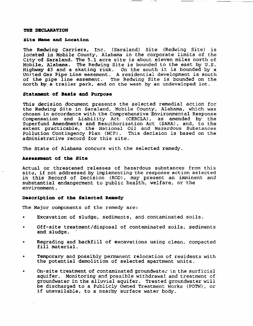
THE DECLARATION
Site Name and Location
The Redwing Carriers, Inc. (Saraland) Site (Redwing Site) islocated in Mobile County, Alabama in the corporate limits of theCity of Saraland. The 5.1 acre site is about eleven miles north ofMobile, Alabama. The Redwing Site is bounded to the east by U.S.Highway 43 and a skating rink. On the south it is bounded by aUnited Gas Pipe Line easement. A residential development is southof the pipe line easement. The Redwing Site is bounded on thenorth by a trailer park, and. on the west by an undeveloped lot.
Statement of Basis and Purpose
This decision document presents the selected remedial action forthe Redwing Site in Saraland, Mobile County, Alabama, which waschosen in accordance with the Comprehensive Environmental ResponseCompensation and Liability Act (CERCLA), as amended by theSuperfund Amendments and Reauthorization Act (SARA), and, to theextent practicable, the National Oil and Hazardous SubstancesPollution Contingency Plan (NCP). This decision is based on theadministrative record for this site.
The State of Alabama concurs with the selected remedy.
Assessment of the Site
Actual or threatened releases of hazardous substances from thissite, if not addressed by implementing the response action selectedin this Record of Decision (ROD) , may present an imminent andsubstantial endangerment to public health, welfare, or theenvironment.
Description of the Selected RemedyThe Major components of the remedy are:
• Excavation of sludge, sediments, and contaminated soils.
• Off-site treatment/disposal of contaminated soils, sedimentsand sludge.
• Regrading and backfill of excavations using clean, compactedfill material.
• Temporary and possibly permanent relocation of residents withthe potential demolition of selected apartment units.
• On-site treatment of contaminated groundwater in the surf icialaquifer. Monitoring and possible withdrawal and treatment ofgroundwater in the alluvial aquifer. Treated groundwater willbe discharged to a Publicly Owned Treatment Works (POTW), orif unavailable, to a nearby surface water body.

This remedy is the only and final remedial action for the site.The function of this remedy is to reduce the risks associated withexposure to contaminated soils, sediments, and ground water.
The selected remedy will:
1. Prevent migration of contaminated groundwater.
2. Prevent human exposure to contaminated soils, sediments andsludge.
3. Permanently reduce the toxicity of the harmful constituents inall media.
4. Prevent migration of site contaminants via drainage pathways.
Statutory Determination*The selected remedy is protective of human health and theenvironment, complies with Federal and State requirements that arelegally applicable or relevant and appropriate to the remedialaction, and is cost-effective. However, because treatment of theprincipal threats of the site was not found to be practicable, thisremedy does not satisfy the statutory preference for treatment asa principal element.
Because this remedy will result in hazardous substances remainingon-site above health-based levels, a review will be conductedwithin five years after commencement of remedial action to ensurethat the remedy continues to provide adequate protection of humanhealth and the environment.
Patrick K. Tobin DateActing Regional Administrator
RECORD OF DECISIONREDWING CARRIERS, INC. (SARALAND)
NPL SITE
DECEMBER 15, 1992
TABLE OF CONTENTS
1.0 SITE NAME. LOCATION AND DESCRIPTION . . . . . . . . . . . . . 1
2.0 SITE HISTORY AND ENFORCEMENT ACTIVITIES . . . . . . . . . . . 5
3.0 HIGHLIGHTS OF COMMUNITY PARTICIPATION . . . . . . . . . . . . 5
4.0 SCOPE AND ROLE OF RESPONSE ACTION . . . . . . . . . . . . . . 7
5.0 SUMMARY OF SITE CHARACTERISTICS . . . . . . . . . . . . . . . 85.1 SITE GEOLOGY . . . . . . . . . . . . . . . . . . . . . . 105.2 SITE HYDROGEOLOGY . . . . . . . . . . . . . . . . . . . . 105.3 AREA DRINKING WATER SOURCES . . . . . . . . . . . . . . . . 115.4 SUMMARY OF SITE CONTAMINATION . . . . . . . . . . . . . . 11
5.4.1 CHEMICALS DETECTED DURING THE SITE INVESTIGATION 125.4.2 CHEMICALS DETECTED IN GROUNDWATER . . . . . . . 125.4.3 SURFACE WATER PATHWAY INVESTIGATION . . . . . . 125.4.4 AIR PATHWAY INVESTIGATION . . . . . . . . . . . 24
5.5 FATE AND TRANSPORT . . . . . . . . . . . . . . . . . . . 245.6 SOURCE AREAS OF CONTAMINATION . . . . . . . . . . . . . . 28
6.0 SUMMARY OF SITE RISKS . . . . . . . . . . . . . . . . . . . . 286.1 CONTAMINANTS OF CONCERN . . . . . . . . . . . . . . . . . 326.2 EXPOSURE ASSESSMENT . . . . . . . . . . . . . . . . . . . 32
6.2.1 EXPOSURE PATHWAYS . . . . . . . . . . . . . . . 386.3 TOXICITY ASSESSMENT; DOSE RESPONSE EVALUATION . . . . . . 466.4 RISK CHARACTERIZATION . . . . . . . . . . . . . . . . . . 526.5 UNCERTAINTY ANALYSIS . . . . . . . . . . . . . . . . . . 536.6 HUMAN HEALTH SUMMARY . . . . . . . . . . . . . . . . . . 566.7 ENVIRONMENTAL EVALUATION . . . . . . . . . . . . . . . . 56
6.7.1 UNCERTAINTY ANALYSIS . . . . . . . . . . . . . 576.8 RISK ASSESSMENT SUMMARY . . . . . . . . . . . . . . . . . 576.9 CHEMICALS OF CONCERN AND CLEANUP LEVELS . . . . . . . . . 586.10 CONCLUSION . . . . . . . . . . . . . . . . . . . . . . . 53
7.0 DESCRIPTION OF ALTERNATIVES . . . . . . . . . . . . . . . . . 6161616263646466
8.0 SUMMARY OF COMPARATIVE ANALYSIS OF ALTERNATIVES . . . . . . . 708.1 THRESHOLD CRITERIA . . . . . . . . . . . . . . . . . . . 728.2 PRIMARY BALANCING CRITERIA . . . . . . . . . . . . . . . 738.3 MODIFYING CRITERIA . . . . . . . . . . . . . . . . . . . 74
7777777
.1
.2
.3
.4
.5
.6
.7
ALTERNATIVEALTERNATIVEALTERNATIVEALTERNATIVEALTERNATIVE
No.No,No.No.No.
ALTERNATIVE NoARARS AND TBCS
1 . . . . . . . . . . . . . . . . . . . .2 . . . . . . . . . . . . . . . . . . . .3 . . . . . . . . . . . . . . . . . . . .4 . . . . . . . . . . . . . . . . . . . .5 . . . . . . . . . . . . . . . . . . . .6 . . . . . . . . . . . . . . . . . . . .
9.0 THE SELECTED REMEDY . . . . . . . . . . . . . . . . . . . . . 75
10.0 STATUTORY DETERMINATIONS . . . . . . . . . . . . . . . . . . . 81
11.0 DOCUMENTATION OF SIGNIFICANT CHANGES . . . . . . . . . . . . . 81
APPENDIX A . . . . . . . . . . . . . . . . . . . . . . . . . . . . i
APPENDIX B . . . . . . . . . . . . . . . . . . . . . . . . . . . . xiv
ll
LIST OF TABLES
Table Page
TABLE 1 - GEOLOGICAL STRATA . . . . . . . . . . . . . . . . . . . 10
TABLE 2A - RESULTS FROM ORGANIC CHEMICAL ANALYSIS OF SLUDGE ... 14
TABLE 2B - RESULTS FROM INORGANIC CHEMICAL ANALYSIS OF BLACK SLUDGEMATERIAL . . . . . . . . . . . . . . . . . . . . . . . 16
TABLE 3 - REDWING SITE: SUMMARY OF CHEMICALS DETECTED DURINGREMEDIAL INVESTIGATION . . . . . . . . . . . . . . . . 17
TABLE 4 - REDWING SITE: SUMMARY OF ANALYSIS OF THE ALLUVIAL AQUIFER 23
TABLE 5 - REDWING SITE: ORGANIC AND INORGANIC CONSTITUENTSDETECTED IN DITCH SEDIMENTS . . . . . . . . . . . . . . 25
TABLE 6 - AREAS AND VOLUME ESTIMATES FOR SOURCE MATERIAL (INCLUDESSLUDGE) . . . . . . . . . . . . . . . . . . . . . . . . 26
TABLE 7A - CHEMICALS OF POTENTIAL CONCERN FOR SOILS, DITCH,SEDIMENTS, AND TAR-LIKE MATERIAL (SLUDGE) . . . . . . . 33
TABLE 7B - CHEMICALS OF POTENTIAL CONCERN IN GROUNDWATER . . . . . 34
TABLE 8A - SURFACE SOIL AND SEDIMENTS RME CONCENTRATIONS . . . . . 36
TABLE 8B - GROUNDWATER RME CONCENTRATIONS . . . . . . . . . . . . 36
TABLE 9 - EXPOSURE ASSUMPTIONS FOR U/BK MODEL . . . . . . . . . . 39
TABLE 10 - SUMMARY OF USEPA ASSUMPTIONS . . . . . . . . . . . . . 40
TABLE 11 - SUMMARY OF NON-USEPA ASSUMPTIONS . . . . . . . . . . . 41
TABLE 12 - GENERIC EXPOSURE ASSUMPTIONS . . . . . . . . . . . . . 42
TABLE 13 - SPECIFIC EXPOSURE SCENARIO ASSUMPTIONS FOR THE RMERECEPTOR . . . . . . . . . . . . . . . . . . . . . . . 43
TABLE 14 - REFERENCE DOSES, CONCENTRATIONS, AND CANCER SLOPE FACTORS 47
TABLE 15 - TOXICITY EQUIVALENCY FACTORS (TEFs) FOR POLYNUCLEARAROMATIC HYDROCARBONS (PAHs) . . . . . . . . . . . . . 52
TABLE 16 - SUMMARY OF PATHWAY SPECIFIC CARCINOGENIC RISKS . . . . 54
TABLE 17 - SUMMARY OF PATHWAY SPECIFIC TOTAL HAZARD INDICES (NON-CARCINOGENIC RISKS) . . . . . . . . . . . . . . . . . . 55
ill
TABLE 18 - CLEANUP LEVELS FOR SUBSURFACE SOIL . . . . . . . . . . 58
TABLE 19 - CLEANUP LEVELS FOR SURFACE SOIL AND SEDIMENTS . . . . . 59
TABLE 20 - CLEANUP LEVELS FOR GROUNDWATER . . . . . . . . . . . . 60
TABLE 21A - ACTION-SPECIFIC FEDERAL ARARS . . . . . . . . . . . . . 67
TABLE 2IB - CHEMICAL-SPECIFIC FEDERAL ARARS . . . . . . . . . . . . 68
TABLE 21C - STATE OF ALABAMA ARARS . . . . . . . . . . . . . . . . 69
TABLE 22A - SURFACE SOIL AND SEDIMENT EXCAVATION LEVELS . . . . . . 76
TABLE 22B - SUBSURFACE SOIL EXCAVATION LEVELS . . . . . . . . . . . 77
IV

LIST OF FIGURES
Figure
FIGURE 1 - SITE LOCATION . . . . . . . . . . . . . .
FIGURE 2 - AREA LAYOUT . . . . . . . . . . . . . . .
FIGURE 3 - SITE LAYOUT . . . . . . . . . . . . . . .
FIGURE 4 - OLD TERMINAL LAYOUT . . . . . . . . . . .
FIGURE 5 - LOCATION OF SOURCE AREAS . . . . . . . . .
FIGURE 6 - CURRENT SITE PROPERTY AND CONTAINMENT LEVEE
FIGURE 7 - SOURCE AREAS . . . . . . . . . . . . . . .
FIGURE 8 - DEPTHS OF SLUDGE (TAR-LIKE MATERIAL)
Page
2
3
4
6
9
13
29
30
Decision SummaryRecord of Decision
Redwing Carriers Inc. (Saraland)Saraland, Alabama
1.0 SITE NAME. LOCATION AND DESCRIPTION
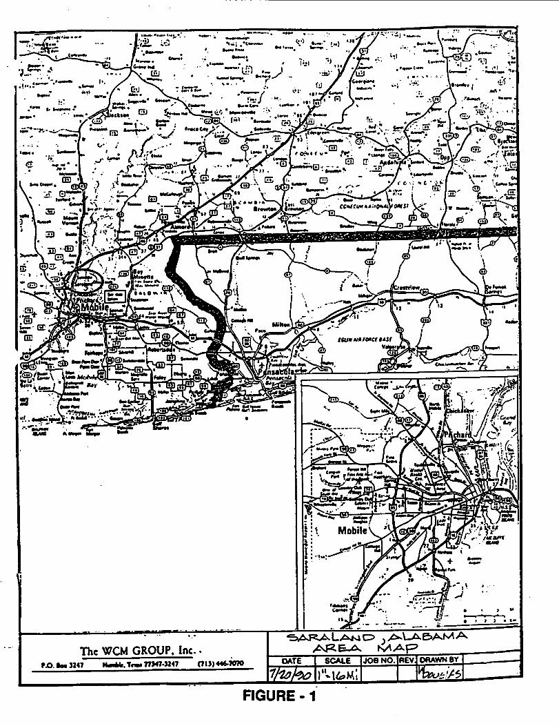
The Redwing Carriers, Inc. (Saraland) Site ("Redwing Site")comprises 5.1 acres and is located at 527 U.S. 43 in the City ofSaraland, Mobile County, Alabama. Currently, thirteen (13)buildings which comprise the office and resident living units ofthe Saraland Apartment complex are built on the Redwing Site.The property is bounded to the north by Cook's Mobile Home Park(containing approximately 53 mobile homes), to the south byprivate residences on Craig Drive, to the west by a wooded areaand private residences on Pierce Street, and to the east by anindoor roller skating rink and U.S. Highway 43. Figure 1 showsthe location of the Redwing Site.
Concrete sidewalks are between and around the apartment buildingsand along the north side of the office building. A paved driveand parking area surrounds the buildings' units and providesaccess from U.S. Highway 43 east of the complex. Two concretelined drainage ditches run parallel to the southern and easternproperty lines of the apartment complex. The southern ditchconverges with the eastern ditch at the southeast corner of theRedwing Site. About 220 feet north of the southeast corner, theeastern ditch turns east and connects to a drainage ditch runningparallel with U.S. Highway 43 at the entrance to the complex. Athird drainage ditch runs along the northern property line. Thisditch is unlined, but has a grass cover. This northern ditchalso joins with the Highway 43 drainage ditch located at thecomplex entrance. A United Gas Pipe Line easement also parallelsthe northern side of this ditch. In the playground of theapartment complex are a slide and swing used by children.
Storm water runoff drains into ditches on the north, south andeast borders of the property. This ditch system empties into adrainage ditch parallel to Highway 43 and leads to Norton Creekapproximately 1/2 mile from the Redwing Site. Wetlands arelocated within a 3 mile radius.
On-site Demographics
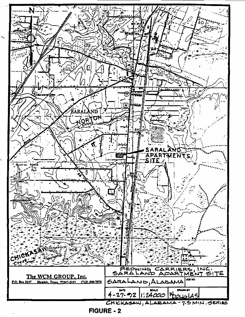
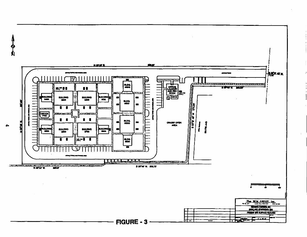
The Redwing Site's 60-unit apartment complex houses approximately160 residents. Eighty to ninety of the residents arepreschool-age or elementary school-age children who frequentlyplay in the yard surrounding the apartments. Figures 2 and 3 aresite maps which show the current layout of the property.
The WCM GROUP. Inc..f.0 to. 1247 H^Mt. TOM 779474247 (7») 446-7070
FIGURE - 1
e±^2^-,
^P5-, --^SN ...rfc
The WCM GROUP. IncP.O. Boi 3147 Humbk. TfMi 77347-3J47 (7131446-7070
V.lAooo- 7/5? MlM
FIGURE - 2
I —I ~i :
NtT27W. HUT
' If !
3IT4TW. 90VS
RGURE- 3
2.0 SITE HISTORY AND ENFORCEMENT ACTIVITIES
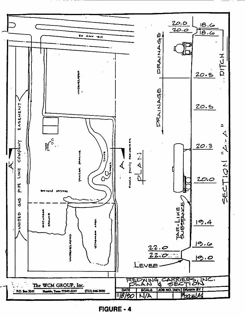
From 1961 to 1971, Redwing Carriers, Inc. (Redwing), a truckingcompany, used the Redwing Site as a terminal for cleaning,repairing and parking its fleet of trucks. The firm transporteda variety of substances, including asphalt, diesel fuel,chemicals and pesticides from local plants along U.S. Highway 43North. During cleaning, untreated substances were released tothe ground. Figure 4 depicts the general condition of theRedwing Site property layout during Redwing's operations.
In 1971 Redwing sold the property to Harrington Inc. which inturn sold the property to Apartments, Inc. on December 22, 1971.On March 26, 1973, Apartments Inc. sold the property to SaralandApartments Ltd. The Saraland Apartments were built on theRedwing Site in 1973.
In 1984, The Alabama Department of Environmental Management(ADEM) investigated residents' complaints about a tar-like sludgeoozing to the surface at numerous locations. In 1985, EPAconducted initial studies in which high concentrations of1,2,4-trichlorobenzene and naphthalene were detected in the soiland in leachate coming from the sludge.
EPA sent notice letters to potentially responsible parties (PRPs)in 1985. EPA entered into an Administrative Order on Consent(AOC) on July 8, 1985 with Redwing. Under the order, Redwing wasrequired and continues to periodically inspect the site andremove any visible sludge on the surface.
The Redwing Site was proposed for listing on the NationalPriorities List (NPL) in 1988 and finalized in February 1990. InJune 1990, Redwing Carriers Inc. entered into an AdministrativeOrder on Consent with EPA to conduct the RemedialInvestigation/Feasibility Study (RI/FS) to determine the natureand extent of contamination at the site, to evaluate theassociated risks, and to evaluate alternatives for eliminatingthose threats. Redwing, under EPA's oversight, began fieldactivities for the first phase of the remedial investigation inJanuary 1991. The RI/FS was completed in July of 1992.
3.0 HIGHLIGHTS OF COMMUNITY PARTICIPATION
All basic requirements for public participation under CERCLAsections 113(k)(2)(B)(i-v) and 117 were met in the remedyselection process. Because the local community has been veryinterested and involved in the Redwing Site status during theremoval and the remedial activities at this site, communityrelations activities remained an important aspect throughout theRI/FS process.
The WCM GROUP. Inc.lot 3247 H-fck.T-77M7.J247 (711)446-7070
RGURE- 4
The community relations program at the Redwing Site was designedto maintain communication between the residents in the affectedcommunity and the government agencies conducting remedialactivities at the Redwing Site. Frequent communication with on-site residents and local officials has been maintained as apriority. Special attention has been directed toward keeping thecommunity informed of all study results. Meetings were held withSaraland city officials and EPA staff prior to the initiation ofthe RI/FS. Prior to approval of the RI/FS Workplan, EPAofficials met with the community at an availability session inDecember 1990 to inform residents of EPA's intentions and toobtain input concerning sampling locations and health and safetyprocedures.
Once the first phase of the RI/FS was complete, EPA met with thecommunity again in August 1991 to present the Preliminary SiteCharacterization Summary which detailed the results of the firstphase of the investigation. EPA also discussed the rationale forthe subsequent sampling investigation, Phase II. On August 11,1992 after the finalization of the Remedial Investigation Reportand the completion of the Draft Feasibility Study, EPA presentedits preferred remedy for the Redwing Site during a public meetingat the Saraland Civic Center, 731 Mae Street, Saraland, Alabama.The 30-day public comment period began on August 1, 1992 and wasextended through September 29, 1992 pursuant to requests from thepublic. A copy of the Administrative Record upon which theremedy was based, is located at the Saraland Public Library at111 Saraland Loop, Saraland Alabama, 36571 and extra copies ofthe study were provided to a community group interested incommenting on the proposed plan. EPA's responses to commentswhich were received during the comment period are contained inAppendix A.
4.0 SCOPE AND ROLE OF RESPONSE ACTION
This remedy is the final remedial action for the site. Thefunction of this remedy is to reduce the risks associated withexposure to contaminated soils, sediments, ground water andsludge.
The selected remedial alternative will address four conditionswhich pose a threat to human health and the environment:
• Contaminated qroundwater in the surficial and alluvial aquifers(may potentially impact drinking water supplies).
• Ditch sediments along the northern, eastern and southernboundaries of the apartment complex property (may pose a directcontact threat to the public health).
• Sludge in the upper five feet of on-site soils (presents a
7
continuing direct contact threat to the public health).
• Sludge and contaminated subsurface soils (present a continuingsource of contamination to the surficial aquifer).
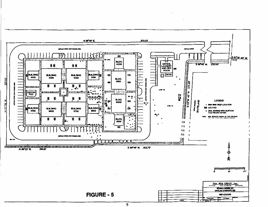
Groundwater at the Redwing Site has been contaminated by thesludge and contaminated subsurface soils. Figure 5 shows theareas where the sludge/contaminated soil have been encountered.These areas correspond to the locations where the highestconcentrations of contamination has been found in the surficialaquifer. This is the principal threat posed by conditions at thesite.
Pathways of exposure include:
• Ingestion of contaminated soil, sediments, and sludge
• Dermal contact with contaminated soil/sediments/sludge andpotential absorption of contaminants
• Ingestion of contaminated groundwater
• Inhalation of vapors from volatile constituents contained inthe contaminated media.
• Migration of site related contaminants to off-site areas viadrainage pathways.
The major components of the remedy are:
• Excavation of sludge, contaminated soils and sediments.
••Off-site materials treatment/disposal.
• Regrading and backfill of excavations using clean compactedfill material.
• Temporary and possibly permanent relocation of residents withthe potential demolition of selected apartment units.
• On-site treatment of contaminated groundwater in the surficialaquifer. Monitoring, possible withdrawal and treatment ofgroundwater in the alluvial aquifer. Treated groundwater willbe discharged to a Publicly Owned Treatment Works (POTW), or ifunavailable, to a nearby surface water body.
5.0 SUMMARY OF SITE CHARACTERISTICS
<psi
oz
NW4TE. S59231
1
! —
G
———
—
?
^
•jl
<\
1
ft
BU
I_CMO
XXID
IXISO
KM10
*1
me0
k-i
i\
rwBB
*-.
BUU3MO -<•300
TJ
B B JrNB B |• |
BULDMQ AMOO ',_
B B
I iv-
1 II
BE
i BUU«2
P-nrL, H *^ • •
8
'>' BUU"•:. •?<
^ 8d-l
I"1
MNX)
J• r
\
yn»
1
1-
|
a
3—
9
a
I
-\'\'i
BULOMQ•KM)
AT,***M »-«»
J
1 BULDMQ• MOO
4li-'
•
B
»
k
B*•
.
'
^T1,.^ •. —
13
OB
•??09
•*11 ..
•
oa
BUXl»I200
— i* ; : : • ;
BUXX»noo
p J; • ••- j
BUXXtnoo
BUXl1900
03
13
09
. ,
»-» .
tsi .
•
• .••* • • m
5
•
r—
i^
N UTIX W. 215JT•>tKHfrl*Mtf-l!&U!!'li>!>ai-lUVN,M!!>'t-K-'H;35r
HI |
aS 89*46* W. 30275*
FIGURE - 5
The WCU CROUP. Inc
riOCMOM
5.1 SITE GEOLOGY
The Redwing Site geology was determined from regional geologicalinformation and from site-specific data gathered during theRemedial Investigation. The Redwing Site is situated on fillsoils overlying Holocene and possibly Pleistocene alluvium. Fourgeneralized stratigraphic units have been defined as in Table 1below.
TABLE 1 - GEOLOGICAL STRATA
Stratum
III
III
IV
ApproximateDepth Range
(feet)0.0 - 6.0
1.0 - 12.5
4.0 - 29.5
8.0 - 40.0+
Description
Fill: Clayey to silty sand.
Clayey to silty sand withsandy clay and silt lenses .Clay and sandy to silty claywith few silty sand lenses.Sand and silty to clayey sandwith occasional clay lenses.
Details regarding the regional and site geology are contained inthe RI Report.
5.2 SITE HYDROGEOLOGY
The primary aquifer underlying the Redwing Site is a group ofalluvial and terrace deposits ranging in thickness from a thinveneer to more than 150 feet and consisting of fine tocoarse-grained sands, gravel, silts, sandy clay and organicmaterial. The groundwater in the vicinity of the Redwing Site isapproximately 10 feet below land surface. The Redwing Site isunderlain by strata that comprise the Alluvial aquifer of MobileCounty. Three distinct hydrogeologic units were identified fromfour strata underlying the Redwing Site. The designationsassigned to these three units are as follows: (1) the SurficialAquifer (upper sands); (2) a Low Permeability Unit and (3) theAlluvial Aquifer (lower sands). Groundwater in the aquifersbeneath the Redwing Site have been classified as Class IIB forthe surficial groundwater and Class IIA for the alluvial aquifer.Class IIB groundwater is a potential drinking water sourcealthough the groundwater may not be currently used as such.Class IIA groundwater is a current source of drinking water.
10
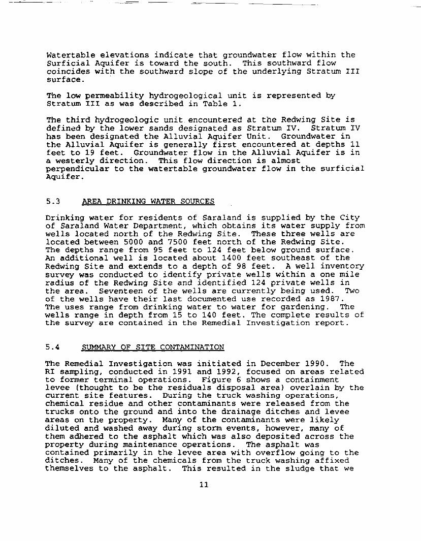
Watertable elevations indicate that groundwater flow within theSurficial Aquifer is toward the south. This southward flowcoincides with the southward slope of the underlying Stratum IIIsurface.
The low permeability hydrogeological unit is represented byStratum III as was described in Table 1.
The third hydrogeologic unit encountered at the Redwing Site isdefined by the lower sands designated as Stratum IV. Stratum IVhas been designated the Alluvial Aquifer Unit. Groundwater inthe Alluvial Aquifer is generally first encountered at depths 11feet to 19 feet. Groundwater flow in the Alluvial Aquifer is ina westerly direction. This flow direction is almostperpendicular to the watertable groundwater flow in the surficialAquifer.
5.3 AREA DRINKING WATER SOURCES
Drinking water for residents of Saraland is supplied by the Cityof Saraland Water Department, which obtains its water supply fromwells located north of the Redwing Site. These three wells arelocated between 5000 and 7500 feet north of the Redwing Site.The depths range from 95 feet to 124 feet below ground surface.An additional well is located about 1400 feet southeast of theRedwing Site and extends to a depth of 98 feet. A well inventorysurvey was conducted to identify private wells within a one mileradius of the Redwing Site and identified 124 private wells inthe area. Seventeen of the wells are currently being used. Twoof the wells have their last documented use recorded as 1987.The uses range from drinking water to water for gardening. Thewells range in depth from 15 to 140 feet. The complete results ofthe survey are contained in the Remedial Investigation report.
5.4 SUMMARY OF SITE CONTAMINATION
The Remedial Investigation was initiated in December 1990. TheRI sampling, conducted in 1991 and 1992, focused on areas relatedto former terminal operations. Figure 6 shows a containmentlevee (thought to be the residuals disposal area) overlain by thecurrent site features. During the truck washing operations,chemical residue and other contaminants were released from thetrucks onto the ground and into the drainage ditches and leveeareas on the property. Many of the contaminants were likelydiluted and washed away during storm events, however, many ofthem adhered to the asphalt which was also deposited across theproperty during maintenance operations. The asphalt wascontained primarily in the levee area with overflow going to theditches. Many of the chemicals from the truck washing affixedthemselves to the asphalt. This resulted in the sludge that we
11
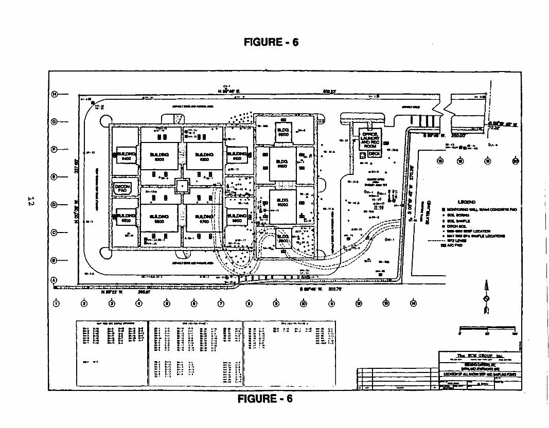
RGURE- 6
|| H""g"Si ts »•£• «^4 t3 M *»-•? *-»***-f *.<• **-!• «-«
«-* •-»
• •
J£
5-M-m-
^_
M-n-11-14-
e-•-t-
c.
|:
*-
ft-
»-»• r-S::! I:••••4 •-
S'3 f:V i* f-»-•« t-• '*• *
: t! \I C>- »-1 !•- -t ».- .-l1
*-*
S^S»•!*
•-N
:? 8P !:?.» » 11 »-U• t» » 11 f'l
:g "•" "';r••-•v »•)= t s.:»• n t •»«-v •. tp. tt . •«*v -** »- 1«•-•• t-'l
•»9IKJ*«.*-*« •
• • ».** M-4 *.tl •• f «.>t M* M .*» M i «• »«-n •»»» M » • » ! *• H -M* *• • -I —— « -^» * > ( . < « •• tM i«• *1 »-• «*-^- -*
FIGURE • 6
currently encounter at the Redwing Site. Tables 2A and 2Bcontain the results from analysis of the sludge. The sludge ispresent at the Redwing Site in two forms: (1) surface seeps at194 locations since 1985 (see Figures 5 and 6), and (2) sludgemixed with soil found in 15 samples across the Redwing Site.There is a direct relationship between constituents found in thesoil and in the surficial groundwater.
5.4.1 CHEMICALS DETECTED DURING THE SITE INVESTIGATION
During the investigation, 39 soil borings were collected with atotal of 123 separate soil samples being analyzed. Thesubstances found most frequently at concentrations above cleanuplevels fall into three major categories: 1) pesticides andherbicides; 2) Volatile organic compounds (VOCs) and 3)Polycydic Aromatic Hydrocarbons (PAHs) .
These substances were found in soils, ditch sediments, andgroundwater across the Redwing Site. The highest levels ofcontamination were detected in the southern and eastern portions(the location of the former containment levee used by Redwing)and across areas of former terminal operations. Inorganicsubstances, which may occur in nature in significant levels, werealso detected in soils, sludge and groundwater.
5.4.2 CHEMICALS DETECTED IN GROUNDWATER
Substances moving from soil and the sludge have contaminatedgroundwater in the surficial, or shallow, aquifer. Highestgroundwater contaminant concentrations are under the eastern halfof the Redwing Site, but the upper aquifer has been affectedunder most of the Redwing Site. Limited movement of contaminantsto the alluvial (lower) aquifer has occurred, but at much lowerlevels.
Table 3 illustrates the migration of contaminants from the sourceareas to the surficial groundwater and alluvial sands. Thegroundwater in the alluvial aquifer was found to be contaminatedin limited areas with some site related constituents. Table 4illustrates the result of the alluvial aquifer sampling.
5.4.3 SURFACE WATER PATHWAY INVESTIGATION
Storm water which contacts surface soils, and sludge that hasseeped to the surface, drains into on-site ditches resulting in apossible exposure pathway. The northern ditch is unlined butcovered with grass. The southern and eastern ditches are nowconcrete-lined but were unlined when Redwing operated at theRedwing Site. Therefore, the study of the ditches extended to
13
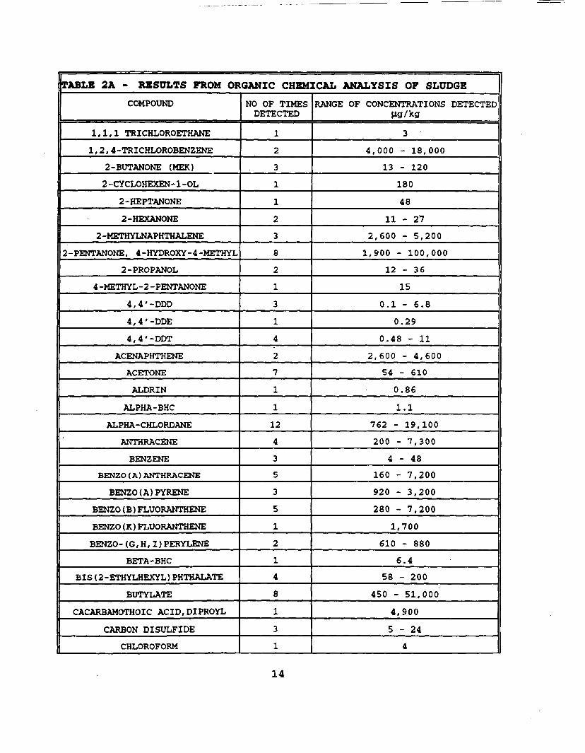
TABLE 2A - RESULTS FROM ORGANIC CHEMICAL ANALYSIS OF SLUDGECOMPOUND
1,1,1 TRICHLOROETHANE
1,2, 4-TRICHLOROBENZENE
2-BUTANONE (MEK)
2 -CYCLOHEXEN- 1 -OL
2-HEPTANONE
2-HEXANONE
2 -METHYLNAPHTHALENE
2 -PENTANONE, 4-HYDROXY-4-METHYL
2-PROPANOL
4 -METHYL-2 -PENTANONE
4,4'-DDD
4, 4 '-DDE
4 , 4 ' -DDT
ACENAPHTHENE
ACETONE
ALDRIN
ALPHA-BHC
ALPHA-CHLORDANE
ANTHRACENE
BENZENE
BENZO (A) ANTHRACENE
BENZO(A)PYRENE
BENZO (B) FLUORANTHENE
BENZO (K) FLUORANTHENE
BENZO- (G, H , I ) PERYLENE
BETA-BHC
BIS (2-ETHYLHEXYL) PHTHALATE
BUTYLATE
CACARBAMOTHOIC ACID.DIPROYL
CARBON DISULFIDE
CHLOROFORM
NO OF TIMESDETECTED
1
2
3
1
1
2
3
8
2
1
3
1
4
2
7
1
1
12
4
3
5
3
5
1
2
1
4
8
1
31
RANGE OF CONCENTRATIONS DETECTEDlig/kg
3
4,000 - 18,000
13 - 120
180
48
11 - 27
2,600 - 5,200
1,900 - 100,000
12 - 36
15
0.1 - 6.8
0.29
0.48 - 11
2,600 - 4 ,600
54 - 610
0.86
1.1
762 - 19,100
200 - 7,300
4 - 4 8
160 - 7 ,200
920 - 3,200
280 - 7,200
1,700
610 - 880
6.4
58 - 200
450 - 51,000
4,900
5 - 2 4
4
14

TABLE 2A - RESULTS FROM ORGANIC CHEMICAL ANALYSIS OF SLUDGE
COMPOUND
CHRYSENE
CYCLOATE
CYCLOHEXANE, DICHLORO
CYCLOHEXANOL, CHLORO
DELTA-BHC
DIBENZOFURAN
DIELDRIN
ENDRIN
ENDRIN KETONE
EPTC
ETHYLBENZENE
FLUORANTHENE
FLUORENE
GAMMA-BHC (LINDANE)
HEPTACHLOR EPOXIDE
INDENO (1,2,3 -CD) PYRENE
METHOXYCHLOR
METHYLENE CHLORIDE
MOLINATE
NAPHTHALENE
NAPHTHALENE, 1 -METHYL
NAPHTHALENE, 2 , 3 -DIMETHYL
PEBULATE
PHENANTHRENE
PYRENE
SULFER, MOL(S8)
TOLUENE
VERNOLATE
XYLENE
NO OF TIMESDETECTED
5
2
1
1
1
2
2
2
1
4
2
6
4
1
1
2
1
3
2
2
1
1
7
5
6
6
3
7
3
RANGE OF CONCENTRATIONS DETECTEDHg/kg
160 - 6,000
6.6 - 10
670
1,400
0.23
2,200 - 6,800
1.1 - 3.4
3.3 - 11
17
39 - 1,900
18 - 120
200 - 23,000
2,300 - 12,000
0.12
1.7
710 - 1,300
13
5 - 4 8
18 - 21
3,900 - 13,000
9,900
5,600
25 - 9,800
850 - 33,000
160 - 12,000
1,600 - 100,000
30 - 52
43 - 130,000
5 - 480
15
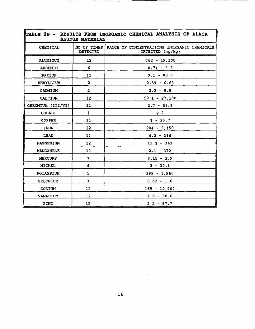
TABLE 2B - RESULTS FROM INORGANIC CHEMICAL ANALYSIS OF BLACKSLUDGE MATERIAL
CHEMICAL
ALUMINUM
ARSENIC
BARIUM
BERYLLIUM
CADMIUM
CALCIUM
CHROMIUM (III/VI)
COBALT
COPPER
IRON
LEAD
MAGNESIUM
MANGANESE
MERCURY
NICKEL
POTASSIUM
SELENIUM
SODIUM
VANADIUM
ZINC
NO OF TIMESDETECTED
12
6
11
2
2
1211
111
12
11
12
10
7
6
5
3
12
12
12
RANGE OF CONCENTRATIONS INORGANIC CHEMICALSDETECTED ( mg / kg )
762 - 19,100
0.71 - 3.3
9.1 - 80.9
0.39 - 0.63
2.2 - 9.5
59.1 - 27,100
2.7 - 51.9
2.7
1 - 23.7
204 - 9,150
4.2 - 316
11.1 - 361
2.1 - 372
0.15 - 1.9
3 - 30.1
199 - 1,960
0.62 - 1.6
169 - 12,900
1.8 - 30.6
2.2 - 97.7
16
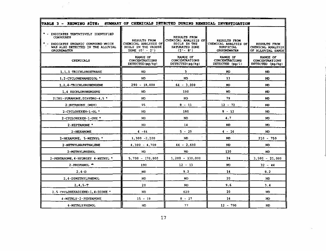
TABLE 3 - REDWING siTKt SUMMARY OF CHEMICALS DETECTED DURING REMEDIAL IMVESTIQATION
• - INDICATES TENTATIVELY IDENTIFIEDCOMPOUNDS
" - INDICATES ORGANIC COMPOUND WHICH' WAS ALSO DETECTED IN THE ALLUVIAL
GROUNDWATER
CHEMICALS
1,1,1 TRICHLOROETHANE
1,2-CYCLOHEHANEDIOL *
1,2, 4-TRICHLOROBENZENE
1,4 DICHLOROBENZENE
2(3H)-FURANONE,DIHYDRO-4,5 '
2-BUTANONE (MEK)
2-CYCLOHEXEN-l-OL '
2-CYCLOHEXEN-l-ONE *
2-HEPTANONE *
2-HEXANONE
2-HEXANONE, 5-METHYL '
2 -METHYLNAPHTHALENE
2-METHYLPHENOL
2 -PENTANONE, 4 -HYDROXY 4-METHYL •
2-PROPANOL *b
2 , 4 - D
2 , 4-DIMETHYLPHENOL
2 ,4 ,5 -T
2,5 CYCLOHEXADIENE- 1, 4-DIONE '
4 -METHLY- 2 - PENTANONE
4-METHLYPHENOL
RESULTS FROMCHEMICAL ANALYSIS OFSOILS IN THE VADOSE
ZONE ( 0 ' - 2 ' )
RANGE OFCONCENTRATIONS
DETECTED(ng/kg)
ND
ND
290 - 18,000
ND
ND
95
ND
ND
ND
4 -64
1,300 -2,200
4 ,300 - 4 ,700
ND
5,700 - 170,000
190
ND
ND
20
ND
15 - 19
ND
RESULTS FROMCHEMICAL ANALYSIS OF
SOILS IN THESATURATED ZONE
(2 1 - 8 ' )
RANGE OFCONCENTRATIONS
DETECTED (|lg/fcg)
3
ND
64 - 3,000
190
ND
8 - 1 3
180
ND
14
5 - 2 9
ND
44 - 2,600
ND
1,200 - 130,000
12 - 13
9.2
ND
ND
620
8 - 2 7
77
RESULTS FROMCHEMICAL ANALYSIS OF
SURFICIALGROUNDWATER
RANGE OFCONCENTRATIONS
DETECTED (Jlg/1)
ND
13
ND
ND
79
12 - 72
8 - 1 2
4.7
ND
4 - 1 6
ND
ND
120
24
ND
14
20
9.6
20
16
12 - 790
RESULTS FROMCHEMICAL ANALYSISOF ALLUVIAL SANDS
RANGE OFCONCENTRATIONS
DETECTED (fig/kg)
ND
ND
ND
ND
ND
ND
ND
ND
ND
ND
210 - 750
ND
ND
3,500 - 21,000
32 - 44
8.2
ND
3.4
ND
ND
ND
17
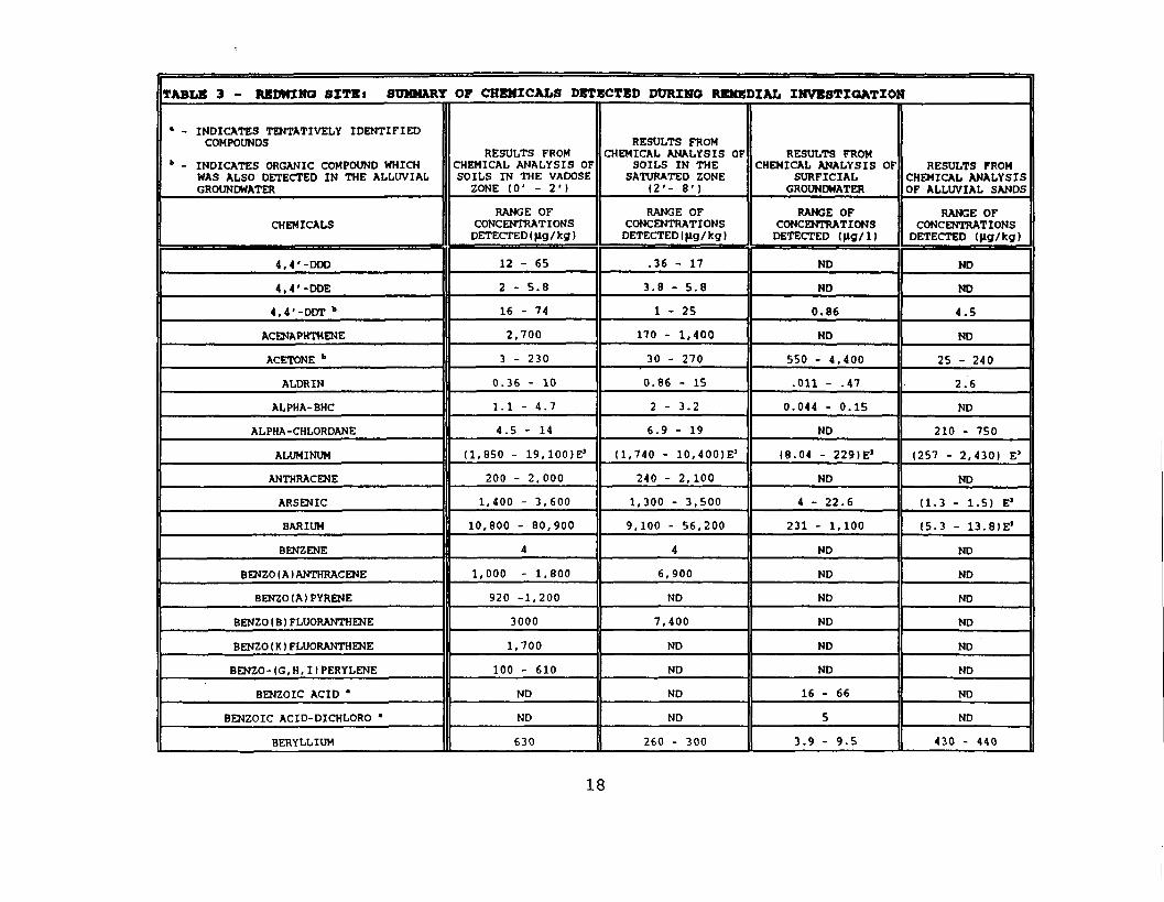
TABLE 3 - REDWING SITE* SUMMARY OF CHEMICALS DETECTED DURING REMEDIAL INVESTIGATION
• - INDICATES TENTATIVELY IDENTIFIEDCOMPOUNDS
b - INDICATES ORGANIC COMPOUND WHICHWAS ALSO DETECTED IN THE ALLUVIALGROUNDWATER
CHEMICALS
4, 4 '-ODD
4, 4 '-DDE
4,4'-DDT b
ACENAPHTHENE
ACETONE b
ALDRIN
ALPHA- BHC
ALPHA-CHLORDANE
ALUMINUM
ANTHRACENE
ARSENIC
BARIUM
BENZENE
BENZO ( A ) ANTHRACENE
BENZO(A)PYRENE
BENZO ( B ) FLUORANTHENE
BENZO ( K ) FLUORANTHENE
BENZO- (G, H, 1 1 PERYLENE
BENZOIC ACID '
BENZOIC ACID-DICHLORO *
BERYLLIUM
RESULTS FROMCHEMICAL ANALYSIS OFSOILS IN THE VADOSE
ZONE ( 0 ' - 2 ' )
RANGE OFCONCENTRATIONS
DETECTED (fig /kg)
12 - 65
2 - 5.8
16 - 74
2,700
3 - 230
0.36 - 10
1.1 - 4.7
4.5 - 14
(1,850 - ig. lOOE1
200 - 2 , 0 0 0
1,400 - 3 ,600
10,800 - 80,900
4
1,000 - 1,800
920 -1,200
3000
1,700
100 - 610
ND
ND
630
RESULTS FROMCHEMICAL ANALYSIS OF
SOILS IN THESATURATED ZONE
(2 ' - 8 ' )
RANGE OFCONCENTRATIONS
DETECTED (fig/kg)
.36 - 17
3.8 - 5.8
1 - 2 5
170 - 1,400
30 - 270
0.86 - 15
2 - 3.2
6.9 - 19
( 1 , 7 4 0 - 10,400|E'
240 - 2,100
1,300 - 3,500
9,100 - 56,200
4
6,900
ND
7 , 4 0 0
ND
ND
ND
ND
260 - 300
RESULTS FROMCHEMICAL ANALYSIS OF
SURFICIALGROUNDWATER
RANGE OFCONCENTRATIONS
DETECTED (|ig/l)
ND
ND
0.86
ND
550 - 4 , 4 0 0
.011 - .47
0.044 - 0.15
ND
(8.04 - 2291E'
ND
4 - 22.6
231 - 1,100
ND
ND
ND
ND
ND
ND
16 - 66
5
3.9 - 9.5
RESULTS FROMCHEMICAL ANALYSISOF ALLUVIAL SANDS
RANGE OFCONCENTRATIONS
DETECTED (Jig/kg)
ND
ND
4.5
ND
25 - 240
2.6
ND
210 - 750
(257 - 2 , 4 3 0 ) E'
ND
(1.3 - 1.5) E3
(5.3 - 13.81E'
ND
ND
ND
ND
ND
ND
ND
ND
430 - 440
18
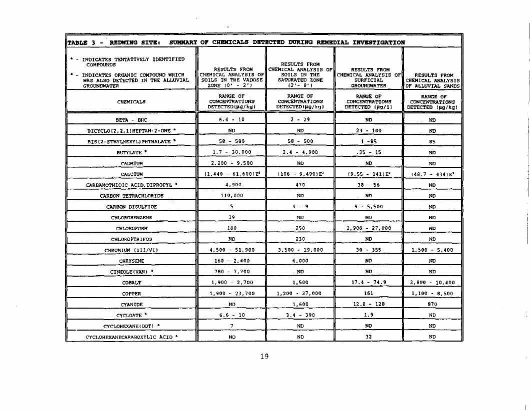
TABLE 3 - REDWING SITBi SUMMARY OF CHEMICALS DETECTED DURING REMEDIAL INVESTIGATION
' - INDICATES TENTATIVELY IDENTIFIEDCOMPOUNDS
» - INDICATES ORGANIC COMPOUND WHICHWAS ALSO DETECTED IN THE ALLUVIALGROUNDWATER
CHEMICALS
BETA - BHC
BICYCLO(2,2,l)HEPTAN-2-ONE '
BISI2-ETHYLHEXYDPHTHALATE *
BUTYLATE b
CADMIUM
CALCIUM
CARBAMOTHIOIC ACID.DIPROPYL '
CARBON TETRACHLORIDE
CARBON DISULFIDE
CHLOROBENZENE
CHLOROFORM
CHLOROPYRIFOS
CHROMIUM ( I I I /VI)
CHRYSENE
CINEOLE(VAN) '
COBALT
COPPER
CYANIDE
CYCLOATE "
CYCLOHEXANE(DOT) '
CYCLOHEXANECARABOXYLIC ACID •
RESULTS FROMCHEMICAL ANALYSIS OFSOILS IN THE VADOSE
ZONE ( 0 ' - 2 ' )
RANGE OFCONCENTRATIONS
DETECTED (Jig/ kg)
6.4 - 10
ND
58 - 580
1.7 - 30 ,000
2,200 - 9,500
( 1 , 4 4 0 - 61,600)E J
4 ,900
110,000
5
19
100
ND
4,500 - 51,900
160 - 2 ,400
780 - 7,700
1,900 - 2,700
1,900 - 23,700
ND
6.6 - 10
7
ND
RESULTS FROMCHEMICAL ANALYSIS OF
SOILS IN THESATURATED ZONE
12'- 8')
RANGE OFCONCENTRATIONSDETECTED (|lg/ kg)
2 - 2 9
ND
58 - 500
2.4 - 4 ,900
ND
(106 - 9 , 4 9 0 ) E S
470
ND
4 - 9
ND
250
230
3,500 - 19,000
6,000
ND
1,500
1,200 - 27,000
1,600
3.4 - 390
ND
ND
RESULTS FROMCHEMICAL ANALYSIS OF
SURFICIALGROUNDWATER
RANGE OFCONCENTRATIONS
DETECTED <|lg/l)
ND
23 - 100
1 -85
.35 - 15
ND
(9.55 - 14DE1
38 - 56
ND
9 - 5,500
ND
2,900 - 27,000
ND
30 - 355
ND
ND
17.4 - 74.9
161
12.8 - 128
1.9
ND
32
RESULTS FROMCHEMICAL ANALYSISOF ALLUVIAL SANDS
RANGE OFCONCENTRATIONS
DETECTED (|ig/kg)
ND
ND
85
ND
ND
(48.7 - 4341E5
ND
ND
ND
ND
ND
ND
1,500 - 5 ,400
ND
ND
2,800 - 10,400
1.100 - 8,500
870
ND
ND
ND
19
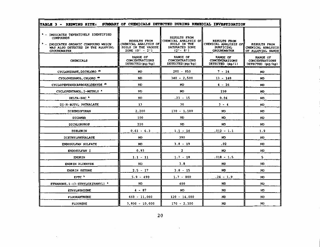
TABLE 3 - REDWING SITEt SUMMARY OP CHEMICALS DETECTED DURING REMEDIAL INVESTIGATION
• - INDICATES TENTATIVELY IDENTIFIEDCOMPOUNDS
" - INDICATES ORGANIC COMPOUND WHICHWAS ALSO DETECTED IN THE ALLUVIALGROUNDWATER
CHEMICALS
CYCLOHEXANE, DICHLORO *
CYOLOHEXANOL, CHLORO *
CYCLOPENTANECARBOXALDEHYDE *
CYCLOPENTANOL, 2-METHLY •
DELTA-BHC *
DI-N-BUTYL PHTHALATE
DIBENZOFURAN
DICAMBA
DICHLORPROP
DIELDRIN
DIETHYLPHTHALATE
ENDOSULFAN SULFATE
ENDOSULFAN I
ENDRIN
ENDRIN ALDEHYDE
ENDRIN KETONE
EPTC b
ETHANONE, 1- (3-ETHYLOXIRANYL) •
ETHYLBENZENE
FLUORANTHENE
FLUORENE
RESULTS FROMCHEMICAL ANALYSIS OFSOILS IN THE VADOSE
ZONE ( 0 ' - 2 ' 1
RANGE OFCONCENTRATIONS
DETECTED (|lg/ kg)
ND
ND
ND
ND
ND
13
2 ,200
100
220
0.61 - 6.3
ND
ND
0.93
1.1 - 11
ND
2.5 - 17
5.9 - 490
ND
4 - 8 7
660 - 11,000
3,800 - 10,000
RESULTS FROMCHEMICAL ANALYSIS OF
SOILS IN THESATURATED ZONE
(2 ' - 8 ' )
RANGE OFCONCENTRATIONS
DETECTED (fig/ kg)
200 - 850
340 - 2,500
ND
ND
.23 - 15
30
130 - 1,100
ND
ND
1.1 - 14
390
3.8 - 19
2
1.7 - 18
3.8
3.8 - 15
1.7 - 800
480
ND
120 - 14,000
170 - 2 ,300
RESULTS FROMCHEMICAL ANALYSIS OF
SURFICIALGROUNDWATER
RANGE OFCONCENTRATIONS
DETECTED (flg/1)
7 - 2 4
13 - 140
4 - 2 6
230
0.04
3 - 4
ND
ND
ND
.012 - 1.1
ND
.02
ND
.018 - 1.5
ND
ND
.24 - 1.9
ND
ND
ND
ND
RESULTS FROMCHEMICAL ANALYSISOF ALLUVIAL SANDS
RANGE OFCONCENTRATIONS
DETECTED (|ig/kg)
ND
ND
ND
ND
ND
ND
ND
ND
ND
1.9
ND
ND
ND
5
ND
ND
ND
ND
ND
ND
ND
20
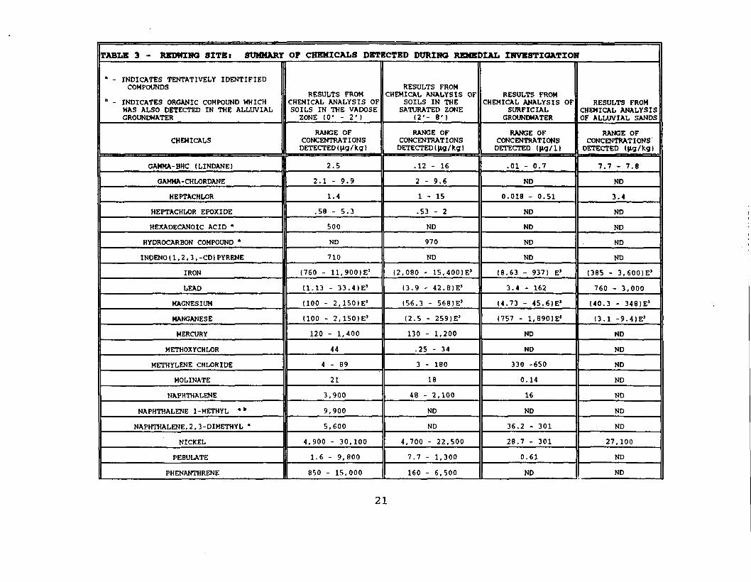
TABLE 3 - REDWING SITE: SUMMARY OF CHEMICALS DETECTED DURING REMEDIAL INVESTIGATION
* - INDICATES TENTATIVELY IDENTIFIEDCOMPOUNDS
b - INDICATES ORGANIC COMPOUND WHICHWAS ALSO DETECTED IN THE ALLUVIALGROUNDWATER
CHEMICALS
GAMMA- BHC (LINDANE)
GAMMA-CHLORDANE
HEPTACHLOR
HEPTACHLOR EPOXIDE
HEXADECANOIC ACID *
HYDROCARBON COMPOUND *
INDENO ( 1 , 2 , 3 , -CD) PYRENE
IRON
LEAD
MAGNESIUM
MANGANESE
MERCURY
METHOXYCHLOR
METHYLENE CHLORIDE
MOLINATE
NAPHTHALENE
NAPHTHALENE 1-METHYL '"
NAPHTHALENE, 2, 3-DIMETHYL '
NICKEL
PEBULATE
PHENANTHRENE
RESULTS FROMCHEMICAL ANALYSIS OFSOILS IN THE VADOSE
ZONE 10' - 2 • I
RANGE OFCONCENTRATIONS
DETECTED (jig /kg)
2.5
2.1 - 9.9
1.4
.58 - 5.3
500
ND
710
(760 - 11.900IE1
(1.13 - 33.41E'
(100 - 2 ,1SO)E '
(100 - 2.150IE1
120 - 1,400
44
4 - 8 9
21
3,900
9,900
5,600
4 ,900 - 30,100
1.6 - 9,800
850 - 15,000
RESULTS FROMCHEMICAL ANALYSIS OF
SOILS IN THESATURATED ZONE
(2 ' - 8 ' )
RANGE OFCONCENTRATIONS
DETECTED I Jig /kg)
. 1 2 - 1 6
2 - 9.6
1 - 1 5
.53 - 2
ND
970
ND
(2 ,080 - 15,400)E J
(3.9 - 42.8)E'
(56.3 - 568)E J
( 2 . 5 - 259)E'
130 - 1,200
.25 - 34
3 - 180
18
48 - 2,100
ND
ND
4 ,700 - 22 ,500
7.7 - 1,300
160 - 6,500
RESULTS FROMCHEMICAL ANALYSIS OF
SURFICIALGROUNDWATER
RANGE OFCONCENTRATIONS
DETECTED (|lg/l)
.01 - 0.7
ND
0.018 - 0.51
ND
ND
ND
ND
(8.63 - 937) EJ
3.4 - 162
(4 .73 - 45.61E'
(757 - 1.890IE'
ND
ND
330 -650
0.14
16
ND
36.2 - 301
28.7 - 301
0.61
ND
RESULTS FROMCHEMICAL ANALYSISOF ALLUVIAL SANDS
RANGE OFCONCENTRATIONS
DETECTED (Jig /kg I
7.7 - 7.8
ND
3.4
ND
ND
ND
ND
(385 - 3 ,600)E '
760 - 3,000
(40 .3 - 348)E J
(3.1 -9. 4 )E'
ND
ND
ND
ND
ND
ND
ND
27,100
ND
ND
21
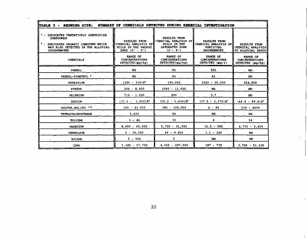
TABLE 3 - REDWING SITEt SUMMARY OF CHEMICALS DETECTED DURING REMEDIAL INVESTIGATION
' - INDICATES TENTATIVELY IDENTIFIEDCOMPOUNDS
b - INDICATES ORGANIC COMPOUND WHICHWAS ALSO DETECTED IN THE ALLUVIALGROUNDWATER
CHEMICALS
PHENOL
PHENOL-DIMETHYL '
POTASSIUM
PYRENE
SELENIUM
SODIUM
SULFUR, MOLIS8 1 •»
TETRACHLOROETHANE
TOLUENE
VANADIUM
VERNOLATE
XYLENE
ZINC
RESULTS FROMCHEMICAL ANALYSIS OFSOILS IN THE VADOSE
ZONE (0' - 2' )
RANGE OFCONCENTRATIONS
DETECTED (jig/ kg)
ND
ND
(206 - 334)E J
160 - 8 ,400
710 - 1,600
(37.1 - 3 .6001E 3
190 - 44,000
1,600
3 - 4 6
8,400 - 49 ,900
2 - 26,000
5 - 990
1,340 - 97,700
RESULTS FROMCHEMICAL ANALYSIS OF
SOILS IN THESATURATED ZONE
12'- 8 ')
RANGE OFCONCENTRATIONS
DETECTED (fig/ kg I
ND
ND
199,000
1000 - 11,000
890
(55.2 - 5 ,430)E J
380 - 100,000
ND
30
5,700 - 31,900
49 - 8,400
5
4,300 - 207,000
RESULTS FROMCHEMICAL ANALYSIS OF
SURFICIALGROUNDWATER
RANGE OFCONCENTRATIONS
DETECTED (|ig/l)
520
61
3260 - 25,500
' ND
3.7
(37.8 - 2 ,370)E J
6 - 9 6
ND
4
16.5 - 580
1.1 - 140
ND
187 - 739
RESULTS FROMCHEMICAL ANALYSISOF ALLUVIAL SANDS
RANGE OFCONCENTRATIONS
DETECTED (|»g/kg)
ND
ND
254,000
ND
ND
( 4 4 . 6 - 89 .6 )E J
230 - 4000
ND
24
4,700 - 8,400
ND
ND
2,700 - 51,100
22
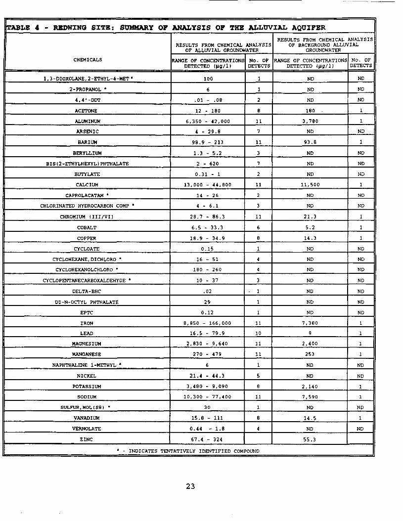
TABLE 4 - REDWING SITE: SUMMARY OF ANALYSIS OF THE ALLUVIAL AQUIFER
CHEMICALS
l,3-DIOXOLANE,2-ETHYL-4-METa
2-PROPANOL •
4, 4 '-DOT
ACETONE
ALUMINUM
ARSENIC
BARIUM
BERYLLIUM
BIS { 2-ETHYLHEXYL ) PHTHALATE
BUTYLATE
CALCIUM
CAPROLACATAM •
CHLORINATED HYDROCARBON COMP •
CHROMIUM (III/VI)
COBALT
COPPER
CYCLOATE
CYCLOHEXANE, DICHLORO *
CYCLOHEXANOLCHLORO '
CYCLOPENTANECARBOXALDEHYDE •
DELTA-BHC
DI-N-OCTYL PHTHALATE
EPTC
IRON
LEAD
MAGNESIUM
MANGANESE
NAPHTHALENE 1 -METHYL *
NICKEL
POTASSIUM
SODIUM
SULFUR, MOLI SB) •
VANADIUM
VERNOLATE
ZINC
RESULTS FROM CHEMICAL ANALYSISOF ALLUVIAL GROUNDWATER
RANGE OF CONCENTRATIONSDETECTED (Jig/1)
100
6
.01 - .08
12 - 180
6,350 - 42,000
4 - 29.8
98.9 - 213
1.3 - 5.2
2 - 620
0.31 - 1
13,000 - 44,800
14 - 26
4 - 6.1
28.7 - 86.3
6.5 - 33.3
18.9 - 34.9
0.15
16 - 51
180 - 260
10 - 37
.02
29
0.12
8,850 - 166,000
16.5 - 79.9
2,830 - 9,640
270 - 479
6
21.4 - 44.3
3,480 - 9,090
10,300 - 77,400
30
15.8 - 111
0.44 - 1.8
67.4 - 324
No. OFDETECTS
1
1
2
8
11
7
11
3
7
2
11
2
3
11
6
8
1
4
4
3
. 1
1
1
11
10
11
11
1
5
8
11
1
8
4
RESULTS FROM CHEMICAL ANALYSISOF BACKGROUND ALLUVIAL
GROUNDWATER
RANGE OF CONCENTRATIONSDETECTED (fig/l)
ND
ND
ND
180 .
3,780
ND
93.8
ND
ND
ND
11,500
ND
ND
21.3
5.2
14.3
ND
ND
ND
ND
ND
ND
ND
7,380
9
2,400
253
ND
ND
2,140
7,590
ND
14.5
ND
55.3
No. OFDETECTS
ND
ND
ND
1
1
ND
1
ND
ND
ND
1
ND
ND
1
1
1
ND
ND
ND
ND
ND
ND
ND
1
1
1
1
ND
ND
1
1
ND
1
ND
' - INDICATES TENTATIVELY IDENTIFIED COMPOUND
23
soils beneath the concrete liners. Contaminants found in the 8ditch samples were similar to those detected in soils. Table 5illustrates the contaminants found in the ditch sediments.
A ditch sample collected below the concrete liner in the easternditch contained the highest number of compounds at the highestconcentrations. Lower concentrations were found in downstreamditch areas.
Site ditches provide only temporary habitats for aquatic plantsand animals. Two water species, the arrowhead plant andmosquitofish, were observed after heavy rain. The mosquitofishwould likely move downstream as ditch water dried up. Sincecontaminants in ditch sediments can move downstream and couldhave moved in the past, EPA used data from on-site ditchsediments to predict effects on plant and animal life indownstream surface water bodies. The analysis of these dataindicates that the highest concentrations are presently separatedfrom the ditch by the concrete liner and that measurable levelsare not presently moving off-site.
5.4.4 AIR PATHWAY INVESTIGATION
A sample of sludge was collected and the vapor from the headspaceanalyzed at temperatures 25°C and 45°C (77 and 113 degreesfahrenheit, respectively). Two volatiles were detected at thehigh temperature and one semivolatile at the low temperature.Additionally, air modeling was conducted using assumptions whichwere more conservative than the above headspace analysis. Thiswas done to predict risk that might be posed if people werebreathing those contaminants in the air. Modeling and airmonitoring results indicated that exposure, above Federal/Statestandards, to chemicals in the air was not likely to occur.
5.5 FATE AND TRANSPORT
An evaluation of the potential for transport and likely fate ofcompounds detected during the remedial investigation consisted ofanalysis of the relationships among the various media at theRedwing Site. This evaluation also entailed a review of thephysical and chemical data for each constituent in allpotentially affected media. To estimate concentrations for mediaand locations where no samples were collected or over time framesfor which data is not available, estimates were made ofconcentrations using environmental fate and transport models.
Exposure pathways for modeling were (1) a source and mechanism ofchemical release; (2) an environmental transport medium; (3) apoint of potential exposure and (4) an exposure route. The mediaevaluated for both present and potential future exposure were (a)groundwater (alluvial and surficial); (b) soils and seeps ofsludge; (c) air and (d) surface water and sediments.
Contaminants have been found primarily in the eastern portion ofthe Redwing Site and in the location of the former levee. Thecontaminants are affiliated with the sludge and the soil that is
24
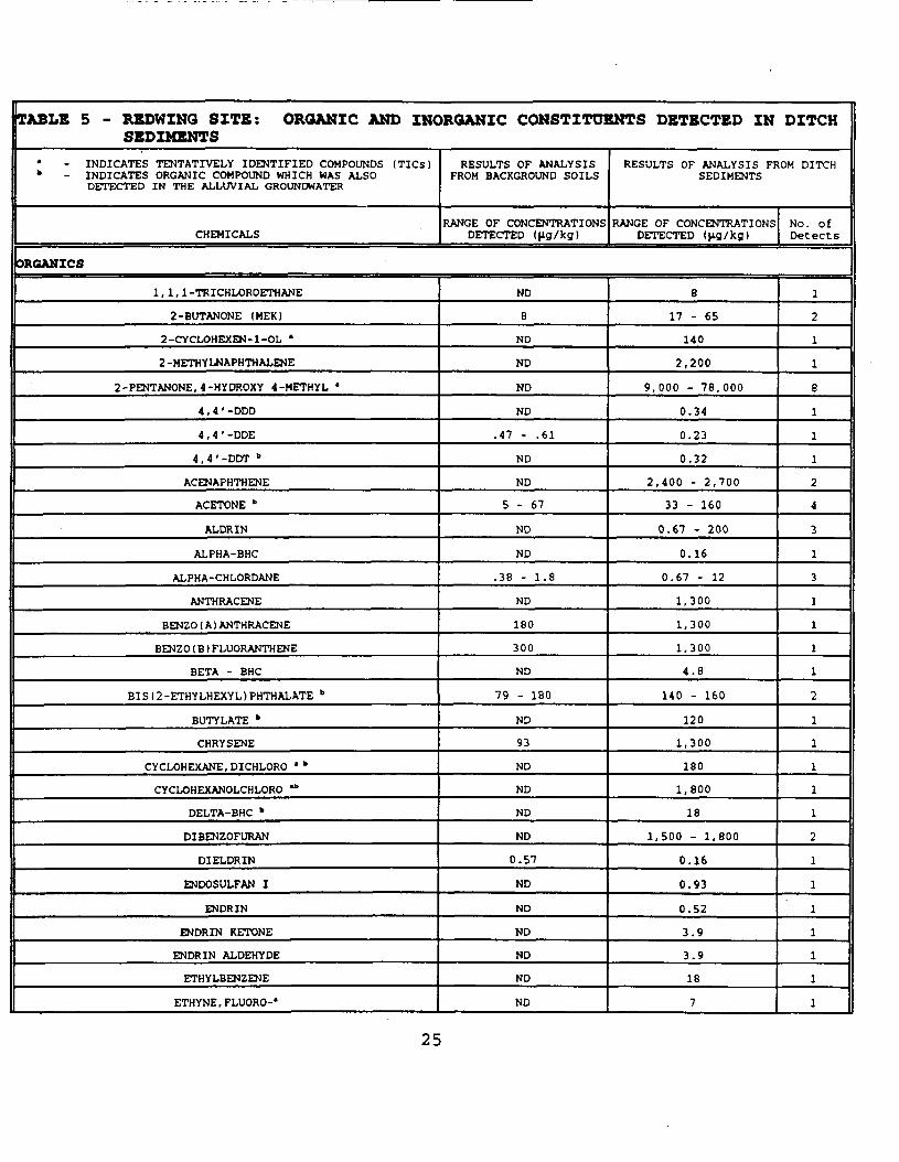
TABLE 5 - REDWING SITE: ORGANIC AND INORGANIC CONSTITUENTS DETECTED IN DITCHSEDIMENTS
• - INDICATES TENTATIVELY IDENTIFIED COMPOUNDS (TICs)" - INDICATES ORGANIC COMPOUND WHICH WAS ALSO
DETECTED IN THE ALLUVIAL GROUNDWATER
CHEMICALS
RESULTS OF ANALYSISFROM BACKGROUND SOILS
RANGE OF CONCENTRATIONSDETECTED ( fig/kg )
ORGANICS
1,1,1 -TRICHLOROETHANE
2-BUTANONE (MEK)
2-CYCLOHEXEN-l-OL *
2 -METHYLNAPHTH ALENE
2-PENTANONE, 4-HYDROXY 4-METHYL a
4, 4 '-ODD
4,4' -DDE
4, 4 '-DOT "
ACENAPHTHENE
ACETONE *
ALDRIN
ALPHA-BHC
ALPHA-CHLORDANE
ANTHRACENE
BENZO ( A ) ANTHRACENE
BENZO ( B ) FLUORANTHENE
BETA - BHC
BIS (2 -ETHYLHEXYL) PHTHALATE "
BUTYL ATE "
CHRYSENE
CYCLOHEXANE.DICHLORO >b
CYCLOHEXANOLCHLORO *"
DELTA-BHC "
DIBENZOFURAN
DIELDRIN
ENDOSULFAN I
ENDRIN
ENDRIN KETONE
ENDRIN ALDEHYDE
ETHYLBENZENE
ETHYNE,FLUORO-'
ND
8
ND
ND
ND
ND
.47 - .61
ND
ND
5 - 6 7
ND
ND
.38 - 1.8
ND
180
300
ND
79 - 180
ND
93
ND
ND
ND
ND
0.57
ND
ND
ND
ND
ND
ND
RESULTS OF ANALYSIS FROM DITCHSEDIMENTS
RANGE OF CONCENTRATIONSDETECTED (Jig /Kg)
8
17 - 65
140
2,200
9,000 - 78,000
0.34
0.23
0.32
2,400 - 2,700
33 - 160
0.67 - 200
0.16
0.67 - 12
1,300
1,300
1,300
4.8
140 - 160
120
1,300
180
1,800
18
1,500 - 1,800
0.16
0.93
D.52
3.9
3.9
18
7
No. ofDetects
1
2
1
1
eiii2
4
3
1
3
1
1
1
1
2
1
1
1
1
1
2
1
1
1
1
1
1
1
25
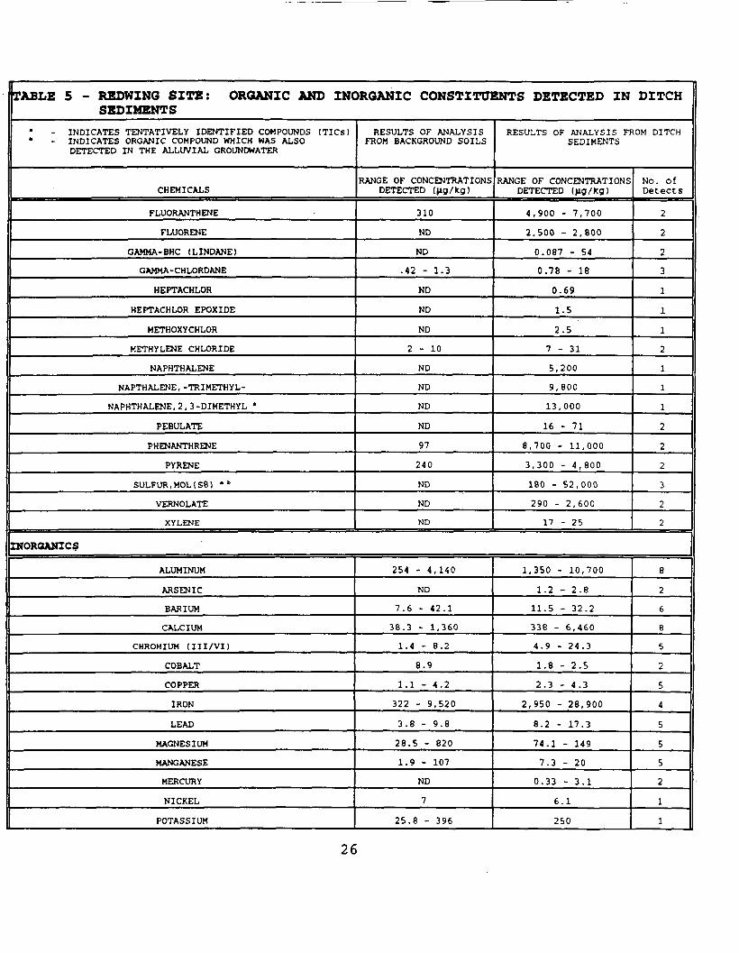
TABLE 5 - REDWING SITE: ORGANIC AND INORGANIC CONSTITUENTS DETECTED IN DITCHSEDIMENTS
• - INDICATES TENTATIVELY IDENTIFIED COMPOUNDS (TICS)* - INDICATES ORGANIC COMPOUND WHICH WAS ALSO
DETECTED IN THE ALLUVIAL GROUNDWATER
CHEMICALS
FLUORANTHENE
FLUORENE
GAMMA- BHC (LINDANE)
GAMMA-CHLORDANE
HEPTACHLOR
HEPTACHLOR EPOXIDE
METHOXYCHLOR
METHYLENE CHLORIDE
NAPHTHALENE
NAPTHALENE, -TRIMETHYL-
NAPHTHALENE, 2, 3 -DIMETHYL •
PEBULATE
PHENANTHRENE
PYRENE
SULFUR, MOL1S8) • "
VERNOLATE
XYLENE
RESULTS OF ANALYSISFROM BACKGROUND SOILS
RANGE OF CONCENTRATIONSDETECTED (jig /kg)
310
ND
ND
.42 - 1.3
ND
ND
ND
2 - 1 0
ND
ND
ND
ND
97
240
ND
ND
ND
RESULTS OF ANALYSIS FROM DITCHSEDIMENTS
RANGE OF CONCENTRATIONSDETECTED (>ig/kg)
4,900 - 7,700
2,500 - 2,800
0.087 - 54
0.78 - 18
0.69
1.5
2.5
7 - 3 1
5,200
9, 800
13,000
16 - 71
8,700 - 11,000
3,300 - 4,800
180 - 52,000
290 - 2,600
17 - 25
No. ofDetects
2
2
2
3
1
1
1
2
1
1
1
2
2
2
3
2
2
INORGANICS
ALUMINUM
ARSENIC
BARIUM
CALCIUM
CHROMIUM (III/VI)
COBALT
COPPER
IRON
LEAD
MAGNESIUM
MANGANESE
MERCURY
NICKEL
POTASSIUM
254 - 4,140
ND
7.6 - 42.1
38.3 - 1,360
1.4 - 8.2
8.9
1.1 - 4.2
322 - 9,520
3.8 - 9.8
28.5 - 820
1.9 - 107
ND
7
25.8 - 396
1,350 - 10,700
1.2 - 2.8
11.5 - 32.2
338 - 6,460
4.9 - 24.3
1.8 - 2.5
2.3 - 4.3
2,950 - 28,900
8.2 - 17.3
74.1 - 149
7.3 - 20
0.33 - 3.1
6.1
250
8
2
6
8
5
2
5
4
5
5
5
2
1
1
26
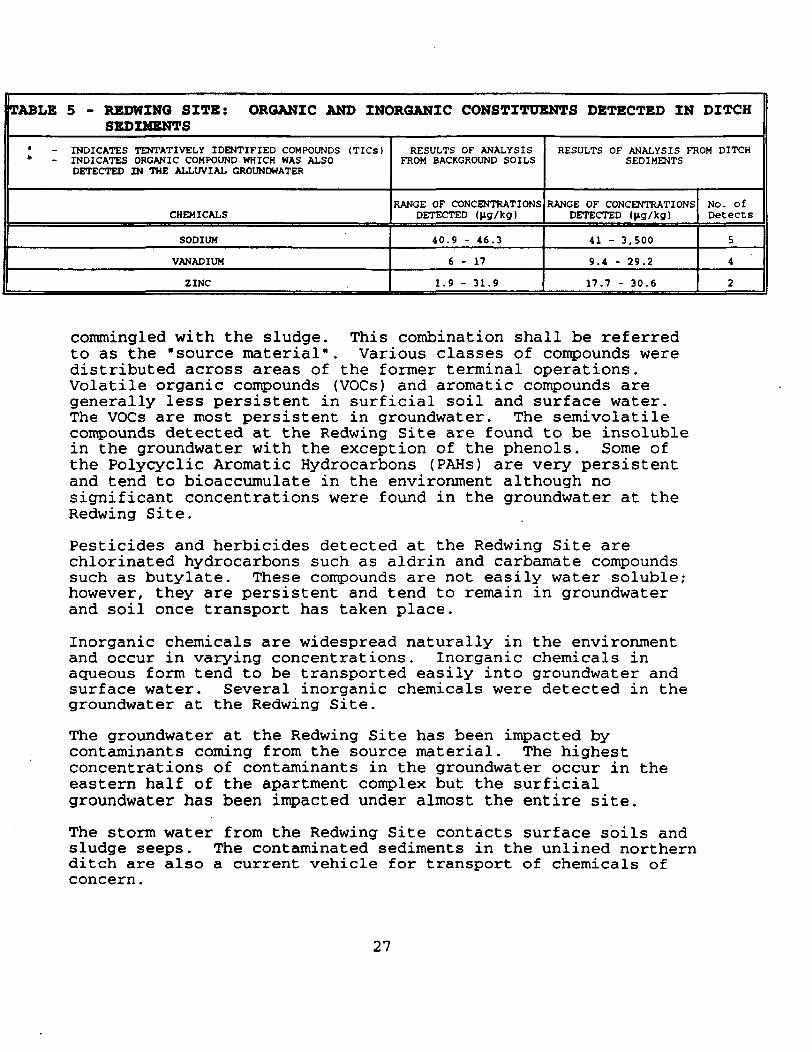
TABLE 5 - REDWING SITE: ORGANIC AMD INORGANIC CONSTITUENTS DETECTED IN DITCHSEDIMENTS
• - INDICATES TENTATIVELY IDENTIFIED COMPOUNDS (TICS)* - INDICATES ORGANIC COMPOUND WHICH WAS ALSO
DETECTED IN THE ALLUVIAL GROUNDWATER
CHEMICALS
SODIUM
VANADIUM
ZINC
RESULTS OF ANALYSISFROM BACKGROUND SOILS
RANGE OF CONCENTRATIONSDETECTED (fig/kg)
40.9 - 46.3
6 - 1 7
1.9 - 31.9
RESULTS OF ANALYSIS FROM DITCHSEDIMENTS
RANGE OF CONCENTRATIONSDETECTED (fig/kg)
41 - 3,500
9.4 - 29.2
17.7 - 30.6
No. ofDetects
5
4
2
commingled with the sludge. This combination shall be referredto as the "source material". Various classes of compounds weredistributed across areas of the former terminal operations.Volatile organic compounds (VOCs) and aromatic compounds aregenerally less persistent in surficial soil and surface water.The VOCs are most persistent in groundwater. The semivolatilecompounds detected at the Redwing Site are found to be insolublein the groundwater with the exception of the phenols. Some ofthe Polycyclic Aromatic Hydrocarbons (PAHs) are very persistentand tend to bioaccumulate in the environment although nosignificant concentrations were found in the groundwater at theRedwing Site.
Pesticides and herbicides detected at the Redwing Site arechlorinated hydrocarbons such as aldrin and carbamate compoundssuch as butylate. These compounds are not easily water soluble;however, they are persistent and tend to remain in groundwaterand soil once transport has taken place.
Inorganic chemicals are widespread naturally in the environmentand occur in varying concentrations. Inorganic chemicals inaqueous form tend to be transported easily into groundwater andsurface water. Several inorganic chemicals were detected in thegroundwater at the Redwing Site.
The groundwater at the Redwing Site has been impacted bycontaminants coming from the source material. The highestconcentrations of contaminants in the groundwater occur in theeastern half of the apartment complex but the surficialgroundwater has been impacted under almost the entire site.
The storm water from the Redwing Site contacts surface soils andsludge seeps. The contaminated sediments in the unlined northernditch are also a current vehicle for transport of chemicals ofconcern.
27
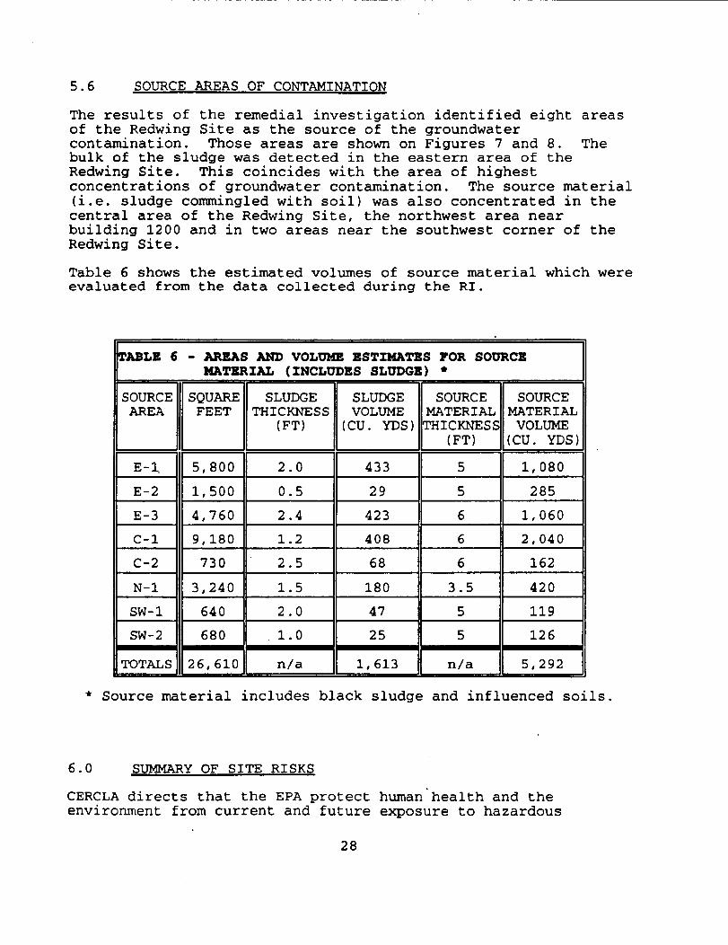
5.6 SOURCE AREAS OF CONTAMINATION
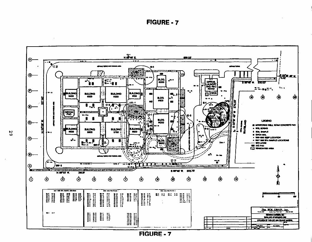
The results of the remedial investigation identified eight areasof the Redwing Site as the source of the groundwatercontamination. Those areas are shown on Figures 7 and 8. Thebulk of the sludge was detected in the eastern area of theRedwing Site. This coincides with the area of highestconcentrations of groundwater contamination. The source material(i.e. sludge commingled with soil) was also concentrated in thecentral area of the Redwing Site, the northwest area nearbuilding 1200 and in two areas near the southwest corner of theRedwing Site.
Table 6 shows the estimated volumes of source material which wereevaluated from the data collected during the RI.
TABLE 6 - AREAS AND VOLUME ESTIMATES FOR SOURCEMATERIAL (INCLUDES SLUDGE) *
SOURCEAREA
E-I,
E-2
E-3
C-l
C-2
N-l
SW-1
SW-2
TOTALS
SQUAREFEET
5,800
1,500
4,7609,180
730
3,240
640
680
26,610
SLUDGETHICKNESS
(FT)
2.0
0.5
2.4
1.2
2.5
1.5
2.0
1.0
n/a
SLUDGEVOLUME
(CU. YDS)
433
29
423408
68
18047
25
1,613
SOURCEMATERIALTHICKNESS
(FT)
5
5
6
6
6
3.5
5
5
n/a
SOURCEMATERIALVOLUME
(CU. YDS)
1,080
285
1,0602,040
162
420
119
126
5,292
Source material includes black sludge and influenced soils
6.0 SUMMARY OF SITE RISKS
CERCLA directs that the EPA protect human health and theenvironment from current and future exposure to hazardous
28
UJDCO
ttrttS?
iitttit
joii
I!
.«•
amis
lllllli
i mi;;
mnn
29
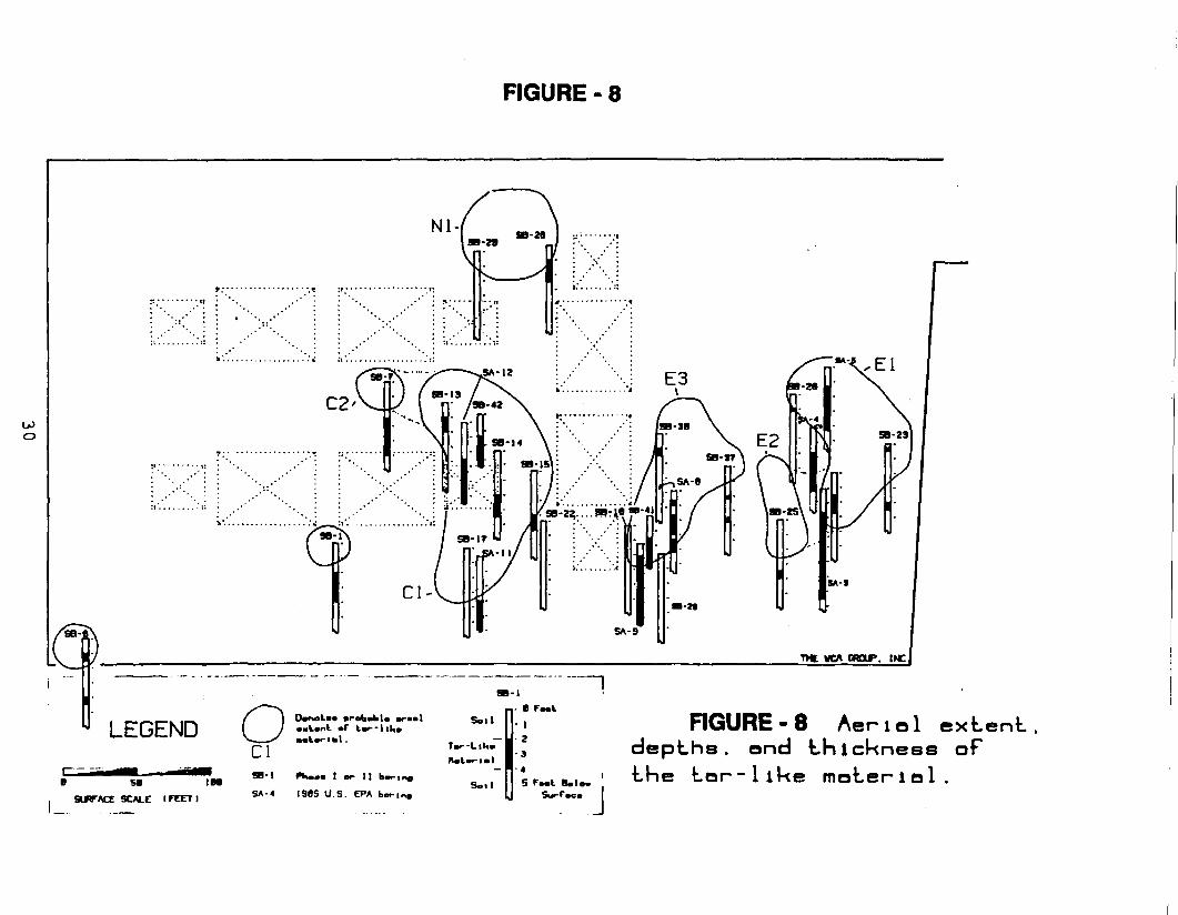
FIGURE - 8
OJo
T>C MCA OOP. INCJ
LEGEND O SB™; ~Cl
Soil
S-li- 0 Foot
I
Tor-Liho 1 2
iui~,.i • 3
— H~<
SA-4 1965 U.S. EPA bor|Soil s rMt Boio.
Surf - JRGURE-8 Aerlol extent,
depths, and thickness ofthe tor-like material.
BLANK PAGE
31
substances at Superfund sites. In order to assess the currentand future risks for the Redwing Site, a baseline risk assessment(BRA) was conducted as part of the Remedial Investigation. TheBRA consists of a human health and environmental assessment ofcurrent and potential exposures at the Redwing Site.
As defined by the 1990 National Oil and Hazardous SubstancesPollution Contingency Plan (NCP), the BRA:
"characterize[s] the current and potential threats to humanhealth and the environment that may be posed by contaminantsmigrating to ground water or surface water, releasing to air,leaching through soil, remaining in the soil, andbioaccumulating in the food chain."
40 C.F.R 300.430(d)(4). The BRA is organized into two- majorcomponents, the Human Health Risk Assessment and the .Environmental Evaluation. The risk assessment processes areevaluated within each component.
6.1 CONTAMINANTS OF CONCERN
Tables 7A and 7B provide a comprehensive list of the contaminantsidentified as chemicals of potential concern (COCs)'at the sitein their various media. Chemicals provided in Tables 8A and 8Bare the contaminants which the baseline risk assessment (BRA)indicated might pose a current or future significant risk. Thecriteria for a significant risk was a carcinogenic risk levelwithin or above the acceptable risk range (i.e., 10E-4 to 10E-6),or a hazard quotient greater than unity (1). Tables 8A and Balso provide the reasonable maximum exposure (RME) concentrationswhich were used in the BRA.
The exposure point concentrations are based on the 95% upperconfidence limit (UCL) of the arithmetic average. The soil UCLsare based on samples taken from the top 1 foot (12 inches) ofsoils or sediments.
6.2 EXPOSURE ASSESSMENT
The exposure assessment is the identification of populations thatmay be exposed to the constituent and the determination of thepotential magnitude and duration of their exposures. Aquantitative exposure assessment is the estimation of themagnitude, duration and frequency of exposure to variousenvironmental media including both current and potential futureexposures.
32
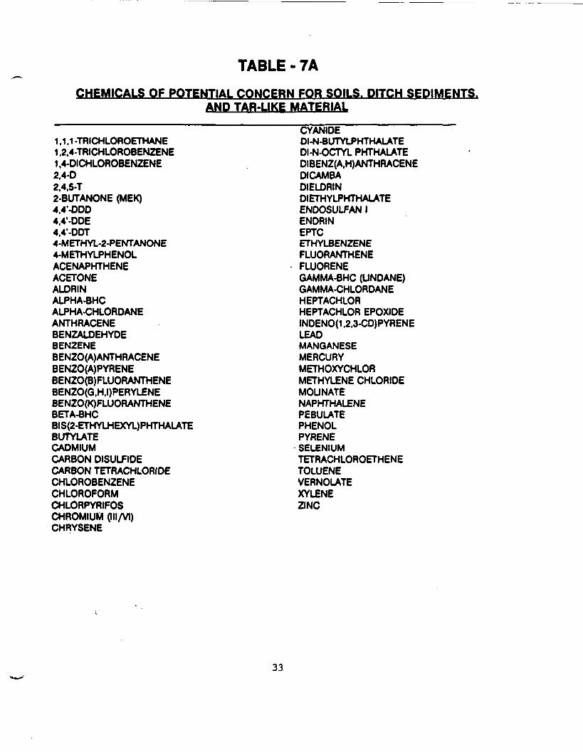
TABLE - 7ACHEMICALS OF POTENTIAL CONCERN FOR SOILS. DITCH SEDIMENTS.
AND TAR-LIKE MATERIAL
1.1.1 -TRICHLOROETHANE1.2.4-TRICHLOROBENZENE1,4-DICHLOROBENZENE2,4-D2,4.5-T2-BUTANONE (MEK)4,4'-DDD4.4'-DDE4.4'-DDT4-METHYL-2-PENTANONE4-METHYLPHENOLACENAPHTHENEACETONEALDRINALPHA-BHCALPHA-CHLORDANEANTHRACENEBENZALDEHYDEBENZENEBENZO(A)ANTHRACENEBEN20(A)PYRENEBENZO(B)FLUORANTHENEBENZO(G,H.I)PERYLENEBENZO(K)FLUORANTHENEBETA-BHCBIS(2-ETHYLHEXYL)PHTHALATEBUTYLATECADMIUMCARBON DISULFIDECARBON TETRACHLORIDECHLOROBENZENECHLOROFORMCHLORPYRIFOSCHROMIUM (IH/VI)CHRYSENE
CYANIDEDI-N-BUTYLPHTHALATEDI-N-OCTYL PHTHALATEDIBENZ(A,H)ANTHRACENEDICAMBADIELDRINDIETHYLPHTHALATEENDOSULFAN IENDRINEPTCETHYLBENZENEFLUORANTHENEFLUORENEGAMMA-BHC (UNDANE)GAMMA-CHLORDANEHEPTACHLORHEPTACHLOR EPOXIDEINDENO(1.2.3-CD)PYRENELEADMANGANESEMERCURYMETHOXYCHLORMETHYLENE CHLORIDEMOUNATENAPHTHALENEPEBULATEPHENOLPYRENESELENIUMTETRACHLOROETHENETOLUENEVERNOLATEXYLENEZINC
33
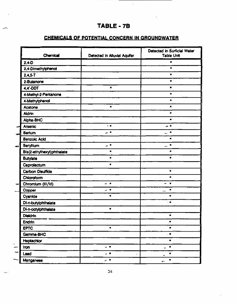
TABLE -7B
CHEMICALS OF POTENTIAL CONCERN IN GROUNDWATER
Chemical2.4-02,4-Dlmethylphenol2,4,5-T2-Butanooe4,4'-ODT4-Methyl-2-Pentanone4-MethylphenolAcetoneAJdrinAlpha-BHCArsenicBariumBenzole AcidBerylliumBis(2-ethy1hexyl)phthalateButytateCaprolactumCarbon DisutfideC hi or of or ITIChromium (III/VI)CopperCyanideDi-n-butylphthalateDkvoctylphthalateDiekJrlnEndrlnEPTCGamma-BHCHeptachlorIronLeadManganese
Detected in Alluvial Aquifer
*
*
• *>- *
__ *••*
— *^ *
*
*
*
_ *- *^ *
Detected in Surficial WaterTable Unit
*•*•**•*•*•
j, *.__ *
*_ *
**
**
_ **•
. *
*•*
. *. ****

TABLE - 7B
CHEMICALS OF POTENTIAL CONCERN IN GROUNDWATER
ChemicalMethylene ChlorideMoiinateNaphthaleneNickelPebulatePhenolSeleniumTolueneVanadiumVemolateZinc
Detected In Alluvial Aquifer
- *
• •*
•* *
Detected in Surficial WaterTable Unit
*•*
~ ****•
•» •*
— *
* Detected in corresponding medium
35
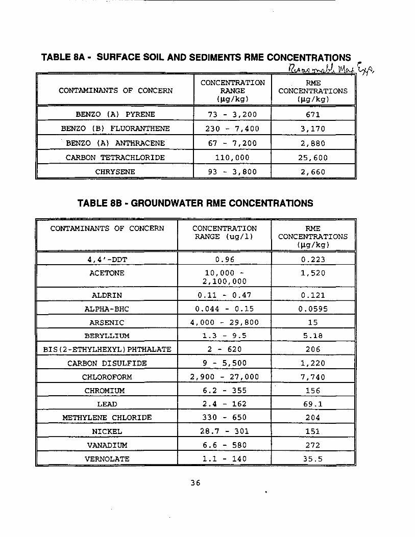
TABLE 8A - SURFACE SOIL AND SEDIMENTS RME CONCENTRATIONSjft OX! rfWi /A ]Mfr-A W/^
CONTAMINANTS OF CONCERN
BENZO (A) PYRENE
BENZO (B) FLUORANTHENE
BENZO (A) ANTHRACENE
CARBON TETRACHLORIDE
CHRYSENE
CONCENTRATIONRANGE(Hg/kg)
73 - 3,200
230 - 7,400
67 - 7,200
110,000
93 - 3,800
RMECONCENTRATIONS
(fig/kg)
671
3,170
2,880
25,600
2,660
TABLE 8B - GROUNDWATER RME CONCENTRATIONS
CONTAMINANTS OF CONCERN
4,4' -DDT
ACETONE
ALDRIN
ALPHA-BHC
ARSENIC
BERYLLIUM
BIS (2-ETHYLHEXYL) PHTHALATE
CARBON BISULFIDE
CHLOROFORM
CHROMIUM
LEAD
METHYLENE CHLORIDE
NICKEL
VANADIUM
VERNOLATE
CONCENTRATIONRANGE (ug/1)
0.96
10,000 -2,100,000
0.11 - 0.47
0.044 - 0.15
4,000 - 29,8001.3 - 9.5
2 - 620
9 - 5,5002,900 - 27,000
6.2 - 3552.4 - 162
330 - 65028.7 - 301
6.6 - 5801.1 - 140
RMECONCENTRATIONS
(Hg/kg)
0.2231,520
0.121
0.0595
155.18
206
1,220
7,740
15669.1
204
151
272
35.5
36
The exposure assessment was conducted in three steps: (1)identification of exposure pathways, (2) estimation ofenvironmental concentrations and (3) selection of exposureassumptions and estimation of human intake. Included was anevaluation of possible exposure doses to people currently livingat the Redwing Site and potential future exposure doses due togroundwater.
Exposure pathways at the Redwing Site were defined in terms ofthe following elements: (1) a, source and mechanism of chemiccj.release into the environment, (2) an environmental transportmedium, (3) a point of potential human exposure and (4) anexposure route (e.g., ingestion of drinking water).
The media considered for both present and potential futureexposure are: (1) groundwater (alluvial and surficial), (2) soilsand seeps of sludge (tar-like material), (3) air, and (4) on-siteditch sediments.
Chemical concentrations used in the exposure assessment werebased on sampling data collected during the remedialinvestigation. The exposure dose was calculated using the 95%upper confidence limit (UCL) of the arithmetic mean of theconcentration unless this was greater than the maximumconcentration detected, in which case the maximum observed valuewas used. Whenever possible, actual sampling data were used.When sampling data was not available, environmental fate andtransport modeling was used to estimate concentrations based onthe sampling data. Calculated chemical concentrations for theexposure assessment used all detected concentrations of achemical plus half the quantification limit for each sample inwhich that chemical was not detected. Only chemicals that weredetected in at least one sample from the Redwing Site wereincluded in these calculations. These data are summarized inTables XI-1 through XI-8 of Appendix XI of the RI Report for allCOCs. Table 8A & 8B of this section provide a summary of themore significant contaminants and their respective RMEconcentrations.
Based on sampling results and Site layout, four areas of possiblecurrent exposure were identified as (1) the eastern portion ofthe Redwing Site (Target Area E), (2) the western portion of theRedwing Site not covered by apartment buildings or pavement(Grassy Area), (3) the Northern Ditch and (4) the apartments'living quarters. The Redwing Site was divided into these fourareas for fate and transport modeling and calculations of humanintake. The receptors considered for the exposure assessmentincluded an adult, a 9-year-old child (the average of a childages 6 through 12 years) and a 4-year-old child (the average of achild ages 6 months through 6 years).
When site-specific data were not available, the exposure
37
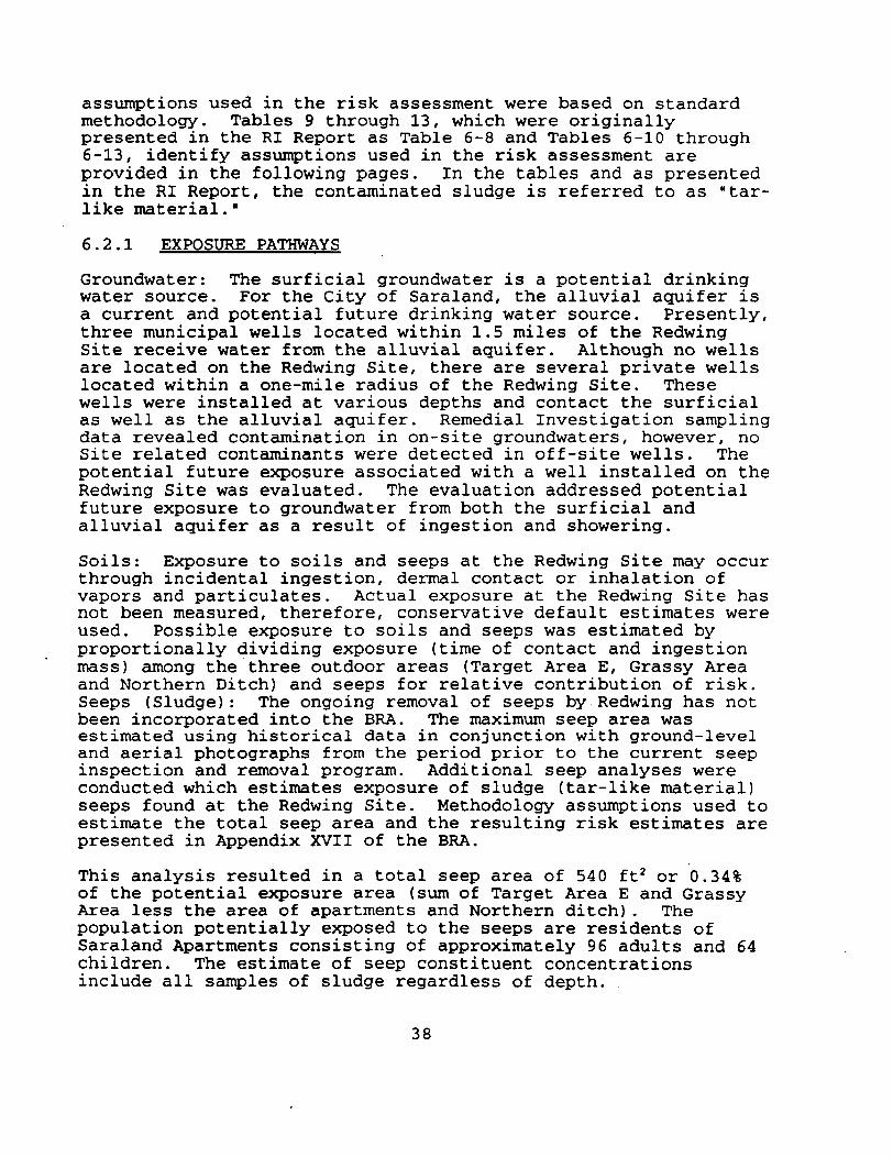
assumptions used in the risk assessment were based on standardmethodology. Tables 9 through 13, which were originallypresented in the RI Report as Table 6-8 and Tables 6-10 through6-13, identify assumptions used in the risk assessment areprovided in the following pages. In the tables and as presentedin the RI Report, the contaminated sludge is referred to as "tar-like material."
6.2.1 EXPOSURE PATHWAYS
Groundwater: The surficial groundwater is a potential drinkingwater source. For the City of Saraland, the alluvial aquifer isa current and potential future drinking water source. Presently,three municipal wells located within 1.5 miles of the RedwingSite receive water from the alluvial aquifer. Although no wellsare located on the Redwing Site, there are several private wellslocated within a one-mile radius of the Redwing Site. Thesewells were installed at various depths and contact the surficialas well as the alluvial aquifer. Remedial Investigation samplingdata revealed contamination in on-site groundwaters, however, noSite related contaminants were detected in off-site wells. Thepotential future exposure associated with a well installed on theRedwing Site was evaluated. The evaluation addressed potentialfuture exposure to groundwater from both the surficial andalluvial aquifer as a result of ingestion and showering.
Soils: Exposure to soils and seeps at the Redwing Site may occurthrough incidental ingestion, dermal contact or inhalation ofvapors and particulates. Actual exposure at the Redwing Site hasnot been measured, therefore, conservative default estimates wereused. Possible exposure to soils and seeps was estimated byproportionally dividing exposure (time of contact and ingestionmass) among the three outdoor areas (Target Area E, Grassy Areaand Northern Ditch) and seeps for relative contribution of risk.Seeps (Sludge): The ongoing removal of seeps by Redwing has notbeen incorporated into the BRA. The maximum seep area wasestimated using historical data in conjunction with ground-leveland aerial photographs from the period prior to the current seepinspection and removal program. Additional seep analyses wereconducted which estimates exposure of sludge (tar-like material)seeps found at the Redwing Site. Methodology assumptions used toestimate the total seep area and the resulting risk estimates arepresented in Appendix XVII of the BRA.
This analysis resulted in a total seep area of 540 ft2 or 0.34%of the potential exposure area (sum of Target Area E and GrassyArea less the area of apartments and Northern ditch). Thepopulation potentially exposed to the seeps are residents ofSaraland Apartments consisting of approximately 96 adults and 64children. The estimate of seep constituent concentrationsinclude all samples of sludge regardless of depth.
38
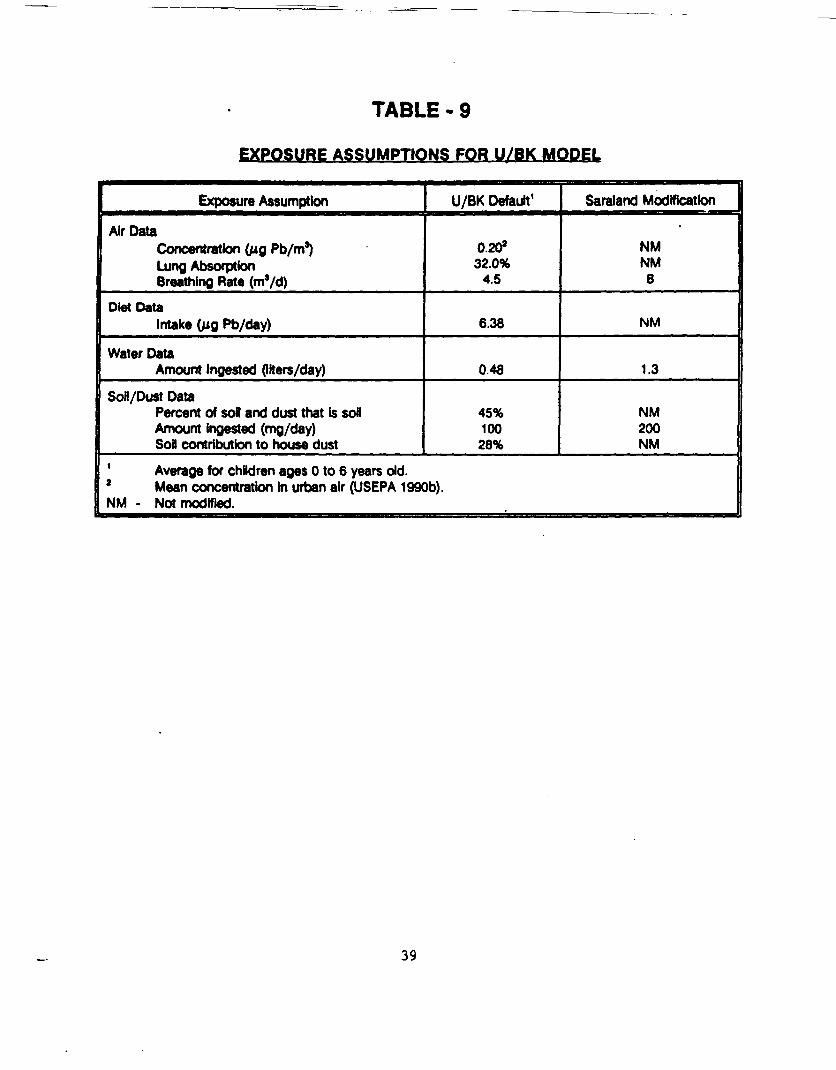
TABLE - 9
EXPOSURE ASSUMPTIONS FOR U/BK MODEL
Exposure Assumption
Air DataConcentration (MQ Pb/m3)Lung AbsorptionBreathing Rate (m'/d)
Diet DataIntake (MQ Pb/day)
Water DataAmount Ingested (liters/day)
Son/Dust DataPercent of sol and dust that is soilAmount ingested (mg/day)Soil contribution to house dust
U/BK Default1
0.20*32.0%
4.5
6.38
0.48
45%10028%
Saraland Modification
NMNM6
NM
1.3
NM200NM
1 Average for children ages 0 to 6 years old.2 Mean concentration in urban air (USEPA 199Gb).NM - Not modified.
39
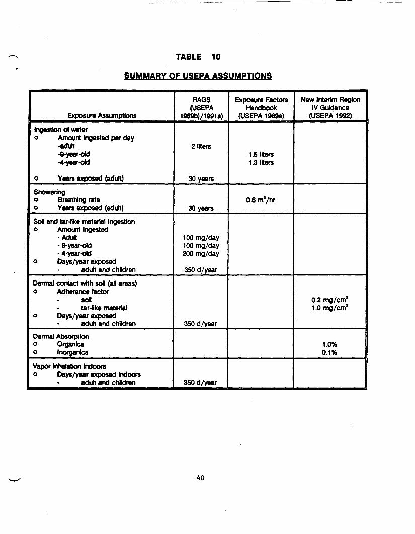
TABLE 10
SUMMARY OF USEPA ASSUMPTIONS
Exposure Assumptions
Ingestton of watero Amount ingested per day
-adult-9-year-old-4-year-old
o Years exposed (adult)Showeringo Breathing rateo Years exposed (adult)Soil and tar-like material Ingestiono Amount ingested
-Adult-9-year-old-4-year-old
o Days/year exposedadult and children
Dermal contact with sol (all areas)o Adherence factor
soltar-like material
o Days/year exposedadult and chBdren
Dermal Absorptiono Organlcso InorganicsVapor inhalation Indoorso Days/year exposed indoors
adult and chldren
RAGS(USEPA
1989b)/1991a)
2 liters
30 years
30 years
100 mg/day100 mg/day200 mg/day
350 d/year
350 d/year
350 d/year
Exposure FactorsHandbook
(USEPA 19893)
1.5 liters1.3 liters
0.6 ms/hr
New Interim RegionIV Guidance
(USEPA 1992)
0.2 mg/cm2
1 .0 mg/cm2
1.0%0.1%
TABLE 11
SUMMARY OF NON-USEPA ASSUMPTIONS
Exposure Assumption
Showering
o Time exposed adutt
o Years exposed (children)
Incidental ingestion of soil anddermal contact (all areas)
o Years exposed-adult
Dermal contact with soil (all areas)
o Surface area• adult-9-year old-4-year old
Inhalation of particulates
o Contact time
Inhalation of vapors
o Outdoor-contact time
o Indoor-contact time
RAGS(USEPA 1989D)
7(12) min per day average(worst) case
NA
SOyears-90th percentile at oneresidence
Dependent on duration ofexposure
Dependent on duration ofexposure
Dependent on duration ofexposure
HypotheticalValues Used inSaraland RiskAssessment
36 min/day
6/5.5 years
9.6 years
2756cm2
3655 cm*2522cm2
8 hr/day
8 hr/day
16 hr/day
Rationale for Non-USEPlAssumptions
Adjust for additional indoor air•xpoaur* (e.g.. dishwasher)due to volatilization from water
Number of years for aach agegroup
95% UCL for residence atSaraland Apartments. Childrenexposed over total age period.
Assumed face and 2/3 upperlimbs for adult, and face,2/3 upper limbs and 1/2 lowerlimbs for children (ICRP 1984)
Assumed to be the reasonablemaximum exposure timeoutdoors
Assumed to be the reasonablemaximum exposure timeoutdoors
Assumed to be the reasonablemaximum exposure timeindoors
41
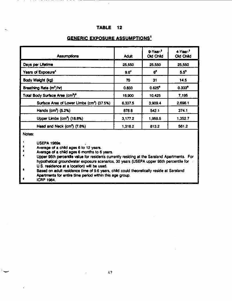
TABLE 12
GENERIC EXPOSURE ASSUMPTIONS1
Assumptions
Days per Lifetime
Years of Exposure4
Body Weight (kg)Breathing Rate (ma/hr)Total Body Surface Area (cm1)'
Surface Area of Lower Limbs (cm2) (37.5%)
Hands (cm2) (5.2%)
Upper Limbs (cm1) (18.6%)
Head and Neck (cm2) (7.8%)
Adult
25.550
9.6*
70
0.833
16,900
6,337.5
878.8
3.177.2
1.318.2
9-Year-2Old Child
25.550
6»
31
0.6256
10,425
3,909.4
542.1
1,959.5
813.2
4-Year-JOld Chid
25.550
5.58
14.5
0.333*
7.195
2,698.1
374.1
1.352.7
561.2
Notes:1 USEPA 198932 Average of a chid ages 6 to 12 years.3 Average of a child ages 6 months to 6 years.4 Upper 95th percentle value for residents currently residing at the Saraland Apartments. For
hypothetical groundwater exposure scenarios, 30 years (USEPA upper 95th percentile forU.S. residence at a location) wfll be used.
9 Based on adult residence time of 9.6 years, child could theoretically reside at SaralandApartments for entire time period within this age group.
• ICRP 1984.
4?
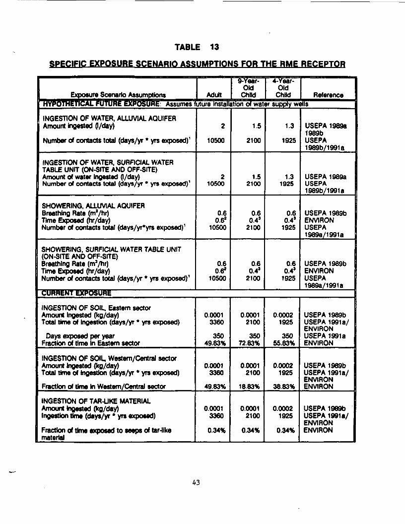
TABLE 13
SPECIFIC EXPOSURE SCENARIO ASSUMPTIONS FOR THE RME RECEPTOR
Exposure Scenario Assumptions Adult
9-Year-OldChild
4-Year-Old
Child ReferencerIYpAThETICAL FUTURE EXPOSURE: Assumes future installation of water supply wells
INGESTION OF WATER, ALLUVIAL AQUIFERAmount ingested (I/day)
Number of contacts total (days/yr * yrs exposed)1
INGESTION OF WATER. SURFICIAL WATERTABLE UNIT (ON-SITE AND OFF-SITE)Amount of water Ingested (I/day)Number of contacts total (days/yr * yrs exposed)1
SHOWERING. ALLUVIAL AQUIFERBreathing Rate (m'/hr)Time Exposed (hr/day)Number of contacts total (days/yr*yrs exposed)1
SHOWERING. SURFICIAL WATER TABLE UNIT(ON-SITE AND OFF-SITE)Breathing Rate (m'/hr)Time Exposed (hr/day)Number of contacts total (days/yr * yrs exposed)1
2
10500
210500
0.60.6*
10500
0.60.6*
10500
1.5
2100
1.52100
0.60.43
2100
0.60.41
2100
1.3
1925
1.31925
0.60.4J
1925
0.60.43
1925
USEPA 1989a1989bUSEPA1989b/1991a
USEPA 1989aUSEPA1989b/1991a
USEPA 1989bENVIRONUSEPA19893/1 991 a
USEPA 1989bENVIRONUSEPA1989a/1991a
CURRENT EXPOSURE
INGESTION OF SOIL. Eastern sectorAmount ingested (kg/day)Total time of ingestton (days/yr * yrs exposed)
Days exposed per yearFraction of time In Eastern sector
INGESTION OF SOIL. Western/Central sectorAmount ingested (kg/day)Total time of ingestion (days/yr * yrs exposed)
Fraction of time in Western/Central sector
INGESTION OF TAR-UKE MATERIALAmount Ingested (kg/day)Ingestion time (days/yr * yrs exposed)
Fraction of time exposed to seeps of tar-likematerial
0.00013360
35049.83%
0.00013360
49.83%
0.00013360
0.34%
0.00012100
35072.83%
0.00012100
18.83%
0.00012100
0.34%
0.00021925
35055.83%
0.00021925
38.83%
0.00021925
0.34%
USEPA 1989bUSEPA 1991 a/ENVIRONUSEPA 1991 aENVIRON
USEPA 1989bUSEPA 1991 a/ENVIRONENVIRON
USEPA 1969bUSEPA 1991a/ENVIRONENVIRON
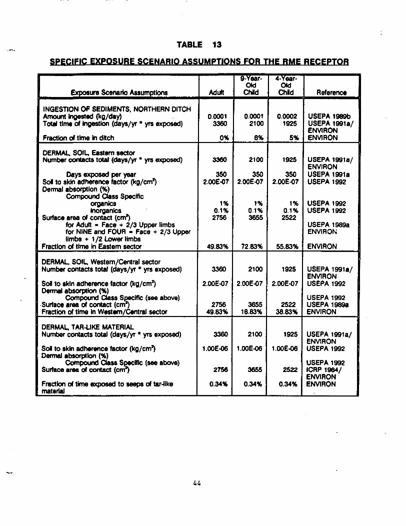
TABLE 13
SPECIFIC EXPOSURE SCENARIO ASSUMPTIONS FOR THE RME RECEPTOR
Exposure Scenario Assumptions
INGEST10N OF SEDIMENTS, NORTHERN DITCHAmount ingested (kg/day)Total time of ingestton (days/yr * yrs exposed)
Fraction of time in ditch
DERMAL. SOIL, Eastern sectorNumber contacts total (days/yr * yrs exposed)
Days exposed per yearSol to skin adherence factor (kg/cm2)Dermal absorption (%)
Compound Class Specificorgantesinorganics
Surface area of contact (cm2)for Adult - Face + 2/3 Upper limbsfor NINE and FOUR - Face + 2/3 Upperlimbs + 1/2 Lower limbs
Fraction of time in Eastern sector
DERMAL, SOIL, Western/Central sectorNumber contacts total (days/yr * yrs exposed)
Sofl to skin adherence factor (kg/cm2)Dermal absorption (%)
Compound Class Specific (see above)Surface area of contact (cm2)Fraction of time in Western/Central sector
DERMAL, TAR-UKE MATERIALNumber contacts total (days/yr * yrs exposed)
Sol to skin adherence factor (kg/cm2)Dermal absorption (%)
Compound Class Specific (see above)Surface area of contact (cm2)
Fraction of time exposed to seeps of tar-likematerial
Adult
0.00013360
0%
3360
3502.00E-07
1%0.1%2756
49.83%
3360
2.00E-07
275649.83%
3360
1.00E-06
2756
0.34%
9-Year-OldChild
0.00012100
8%
2100
3502.00E-07
1%0.1%3655
72.83%
2100
2.00E-07
365518.83%
2100
1.00E-06
3655
0.34%
4-Year-CHdChid
0.00021925
5%
1925
3502.00E-07
1%0.1%2522
55.83%
1925
2.00E-07
252238.83%
1925
1.00E-06
2522
0.34%
Reference
USEPA 1989bUSEPA 1991 a/ENVIRONENVIRON
USEPA 1991a/ENVIRONUSEPA 1991 aUSEPA 1992
USEPA 1992USEPA 1992
USEPA 1989aENVIRON
ENVIRON
USEPA 1991 a/ENVIRONUSEPA 1992
USEPA 1992USEPA 19893ENVIRON
USEPA 1991a/ENVIRONUSEPA 1992
USEPA 1992ICRP 1964/ENVIRONENVIRON
44
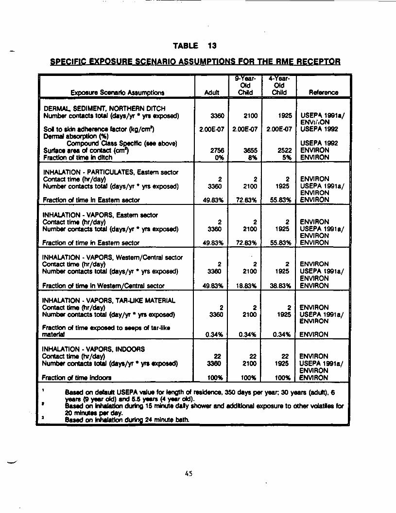
TABLE 13
SPECIFIC EXPOSURE SCENARIO ASSUMPTIONS FOR THE RME RECEPTOR
Exposure Scenario Assumptions
DERMAL. SEDIMENT, NORTHERN DITCHNumber contacts total (days/yr * yrs exposed)
SoB to skin adherence factor (kg/cm2)Dermal absorption (%)
Compound Class Specific (see above)Surface area of contact (cm*)Fraction of time In ditch
INHALATION - P ARTICULATES, Eastern sectorContact time (hr/day)Number contacts total (days/yr * yrs exposed)
Fraction of time hi Eastern sector
INHALATION - VAPORS. Eastern sectorContact time (hr/day)Number contacts total (days/yr * yrs exposed)
Fraction of time in Eastern sector
INHALATION - VAPORS. Western/Central sectorContact time (hr/day)Number contacts total (days/yr * yrs exposed)
Fraction of time in Western/Central sector
INHALATION - VAPORS, TAR-LIKE MATERIALContact time (hr/day)Number contacts total (day/yr * yrs exposed)
Fraction of time exposed to seeps of tar-tikematerial
INHALATION • VAPORS. INDOORSContact time (hr/day)Number contacts total (days/yr • yrs exposed)
Fraction of time Indoors
Adult
3360
2.00E-07
27560%
23360
49.83%
23360
49.83%
23360
49.83%
23360
0.34%
223360
100%
9-Year-Old
Child
2100
2.00E-07
36558%
22100
72.83%
22100
72.83%
22100
18.83%
22100
0.34%
222100
100%
4-Year-Old
Child
1925
2.00E-07
25225%
21925
55.83%
21925
55.83%
21925
38.83%
21925
0.34%
221925
100%
Reference
USEPA 1991 a/ENViAONUSEPA 1992
USEPA 1992ENVIRONENVIRON
ENVIRONUSEPA 1991 a/ENVIRONENVIRON
ENVIRONUSEPA 1991 a/ENVIRONENVIRON
ENVIRONUSEPA 1991 a/ENVIRONENVIRON
ENVIRONUSEPA 1991 a/ENVIRON
ENVIRON
ENVIRONUSEPA 1991 a/ENVIRONENVIRON
1 Based on default USEPA value for length of residence, 350 days per year; 30 years (adult). 6years (9 year old) and 5.5 years (4 year old).
* Based on inhalation during 15 minute daly shower and additional exposure to other volatles for20 minutes per day.3 Based on inhalation during 24 minute bath.
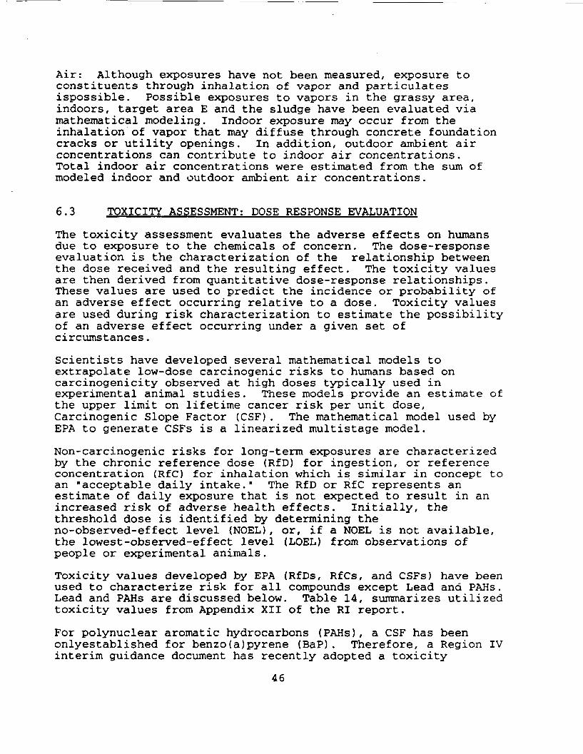
Air: Although exposures have not been measured, exposure toconstituents through inhalation of vapor and particulatesispossible. Possible exposures to vapors in the grassy area,indoors, target area E and the sludge have been evaluated viamathematical modeling. Indoor exposure may occur from theinhalation of vapor that may diffuse through concrete foundationcracks or utility openings. In addition, outdoor ambient airconcentrations can contribute to indoor air concentrations.Total indoor air concentrations were estimated from the sum ofmodeled indoor and outdoor ambient air concentrations.
6.3 TOXICITY ASSESSMENT; DOSE RESPONSE EVALUATION
The toxicity assessment evaluates the adverse effects on humansdue to exposure to the chemicals of concern. The dose-responseevaluation is the characterization of the relationship betweenthe dose received and the resulting effect. The toxicity valuesare then derived from quantitative dose-response relationships.These values are used to predict the incidence or probability ofan adverse effect occurring relative to a dose. Toxicity valuesare used during risk characterization to estimate the possibilityof an adverse effect occurring under a given set ofcircumstances.
Scientists have developed several mathematical models toextrapolate low-dose carcinogenic risks to humans based oncarcinogenicity observed at high doses typically used inexperimental animal studies. These models provide an estimate ofthe upper limit on lifetime cancer risk per unit dose,Carcinogenic Slope Factor (CSF). The mathematical model used byEPA to generate CSFs is a linearized multistage model.
Non-carcinogenic risks for long-term exposures are characterizedby the chronic reference dose (RfD) for ingestion, or referenceconcentration (RfC) for inhalation which is similar in concept toan "acceptable daily intake." The RfD or RfC represents anestimate of daily exposure that is not expected to result in anincreased risk of adverse health effects. Initially, thethreshold dose is identified by determining theno-observed-effect level (NOEL), or, if a NOEL is not available,the lowest-observed-effect level (LOEL) from observations ofpeople or experimental animals.
Toxicity values developed by EPA (RfDs, RfCs, and CSFs) have beenused to characterize risk for all compounds except Lead and PAHs.Lead and PAHs are discussed below. Table 14, summarizes utilizedtoxicity values from Appendix XII of the RI report.
For polynuclear aromatic hydrocarbons (PAHs), a CSF has beenonlyestablished for benzo(a)pyrene (BaP). Therefore, a Region IVinterim guidance document has recently adopted a toxicity
46

TABLE - 14
REFERENCE DOSES. REFERENCE CONCENTRATIONS AND CANCER SLOPE FACTORS
CHEMICAL
AOAftflpntlMiAO
Acolont
AMrin
Anthractfw
B*nz(a)an1lvac«n«'
BMu(a)pyran*
Bmnfctehyd*
utnitno•>„— _ - <h\ai. - — -jfc • • •*tMnzofDyiiuoraninvnt
INI11O|Qni|pMywO9
^ tDonzopjfluofinlMM
•%— ___ i^ MfilriUVfUCNC Add
Bte(2 ttiyttMxyl)p»ittMlaM (BEHP)
Butyta*
Capfotactam
C^ondtouHhto
CMfaoo lrtr«cMortd» - T«tr«chloremrttMM
NON-CARaNOGENIC
iHteLMC(MC/kt/teT)
NA
NA
NA
NA
NA
NA
NA
NA
NA
NA
NA
NA
NA
NA
NA
2J6X10*
NA
MMLMCSOURCE
HEAST1991
Oral RID(-tAt/ 7)
6.00 x10⁴
1.00 x Iff1
3.00*10*
3.00 x Iff'
NA
NA
1.00 x 10 '
NA
NA
3.00 x Iff*
NA
4.00
&OOX104
5.00x10**
5.00x10'
1.00x10⁻¹
7.00 x Iff*
Oral RIDSOURCE
HEAST/IRS 1991
HEAST/mS 1991
HEAST/IRS 1991
HEAST/mS 1991
HEAST1991
HEAST/mS 1991
HEAST1991
HEAST/mS 1991
HEAST/IRS 1991
HEAST1991
HEAST/IRS 1991
HEAST/IRS 1991
CARCINOGENIC
MMLCSFl/(«tA«/ )
NA
NA
1.70 xlO1
NA
6.10 x Iff'
6.10
NA
2.90 x 10*
6.10x10'
NA
8.10 x Iff1
NA
NA
NA
NA
NA
1 JO x Iff1
laMtCSFSOURCE
HEAST/MS 1991
HEAST1991(BtPTEF)
HEAST1991
HEAST/IRS 1991
HEAST1991(BlPTEF)
HEAST1991(BaPTEF)
HEAST/mS 1991
OralCSFlA-t/l*/**)
NA
NA
1.70 x 101
NA
5.80 x Iff1
5.80
NA
2.90 x 10 *
5.80x10'
NA
6.60x10'
NA
1.40x10*
NA
NA
NA
1^0x10'
OralCSFSOURCE
HEAST/IRS 1991
HEAST 1991 (B«PTEF)
HEAST 1991
HEAST/IRS 1991
HEAST 1991(B«PTEF)
HEAST 1991(BaPTEF)
HEAST/mS 1991
HEAST/IRS 1991
47
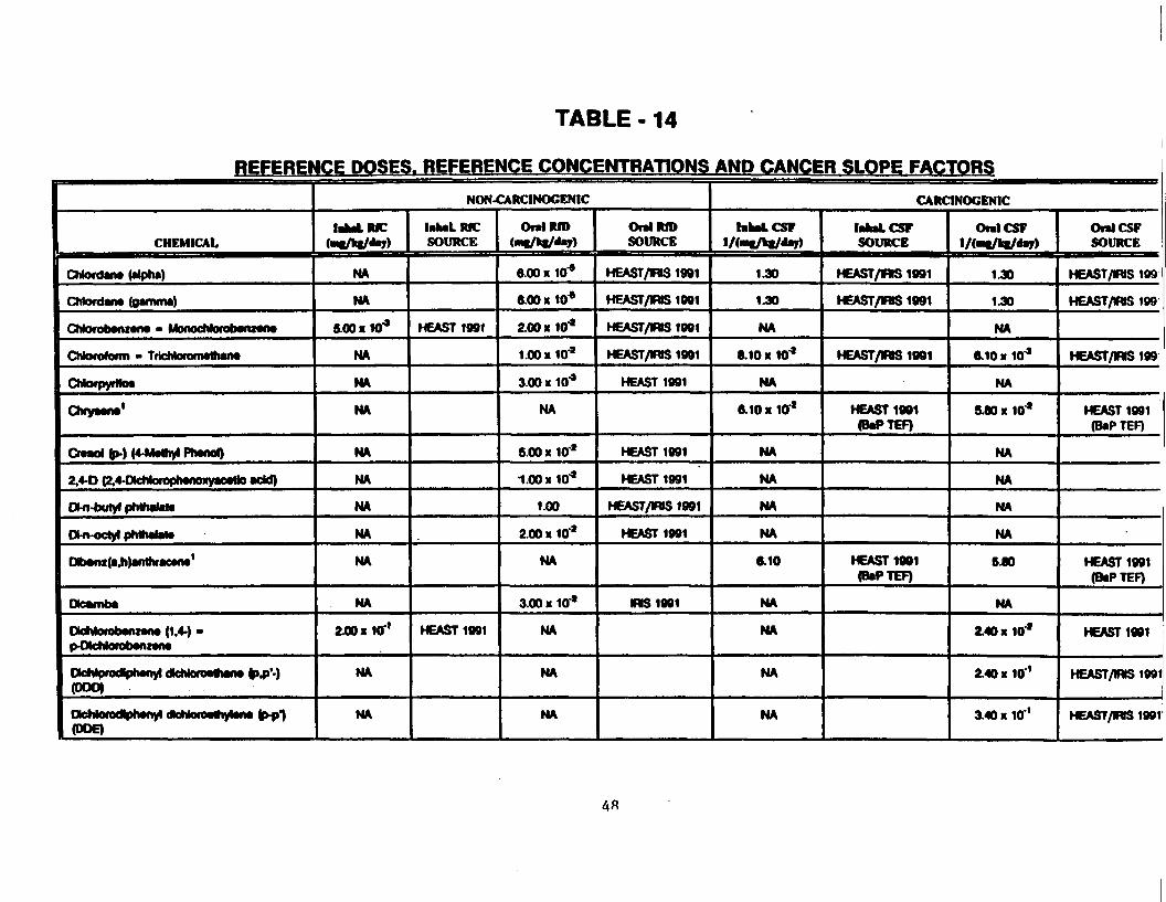
TABLE -14
REFERENCE DOSES. REFERENCE CONCENTRATIONS AND CANCER SLOPE FACTORS
CHEMICAL
CMordana (alpha)
CMonJana (QanwiMt)
CMorotoaniana • MonocMorobanxana
Chloroform • TricMoromathana
CMorpyrHot
Chryaana1
Craaol &>-) (4-Mathyl PhanoO
2.4-D (2.4-DlchtorophanoKyacatlo add)
O-n-butyl phthaJala
DMt-octyt pMhalata
Dlb«u(a.h)afrthracana'
DtdMvibA
OoNorobanzana (1.4-) •p-DlcMorabanzana
(ODD)
ucfwufuui|jiiviiyi uniNuiuvnyiMiv v*~P 9(DOE)
NON-CARCINOGENIC
iBkaLRJC(Ml/kf/Jay)
NA
NA
6.00 K10"*
NA
NA
NA
NA
NA
NA
NA
NA
NA
240 HO'1
NA
NA
lakaLRICSOURCE
HEAST1991
HEAST1991
Oral RID(•H/tt/day)
6.00 x 10*
6.00 M lO4
2.00 x 10*
1.00 x 10*
3.00 x 10*
NA
6.00 x 10*
1.00x10*
1.00
2.00 x 10*
NA
3.00 x 10*
NA
NA
NA
OnlRIDSOURCE
HEAST/mS 1991
HEAST/ttS 1991
HEAST/WS1991
HEAST/IRIS 1991
HEAST1991
HEAST1991
KEAST1991
HEAST/mS 1991
HEAST1991
MS1991
CARCINOGENIC
lakaLCSFl/<i"f/k|/*7>
1.30
1.30
NA
8.10 x 10*
NA
6.10x10*
NA
NA
NA
NA
6.10
NA
NA
NA
NA
hhaLCSrSOURCE
HEAST/WS 1991
HEAST/mS 1991
HEAST/RS 1991
HEAST1991(BaPTEF)
HEAST1991(BaPTEF)
OralCSFl/(«t/k|/«la7)
1.30
1.30
NA
6.10 x 10*
NA
5.80 x 10*
NA
NA
NA
NA
6 JO
NA
Z40x10*
£40 x 10 '
3.40 x 10 '
OnlCSFSOURCE
HEAST/MS 199
HEAST/mS 199
HEAST/MS199
HEAST1991(BaPTEF)
HEAST1991(BaPTEF)
HEAST1991
HEAST/IRIS 1991
HEAST/WS 1991
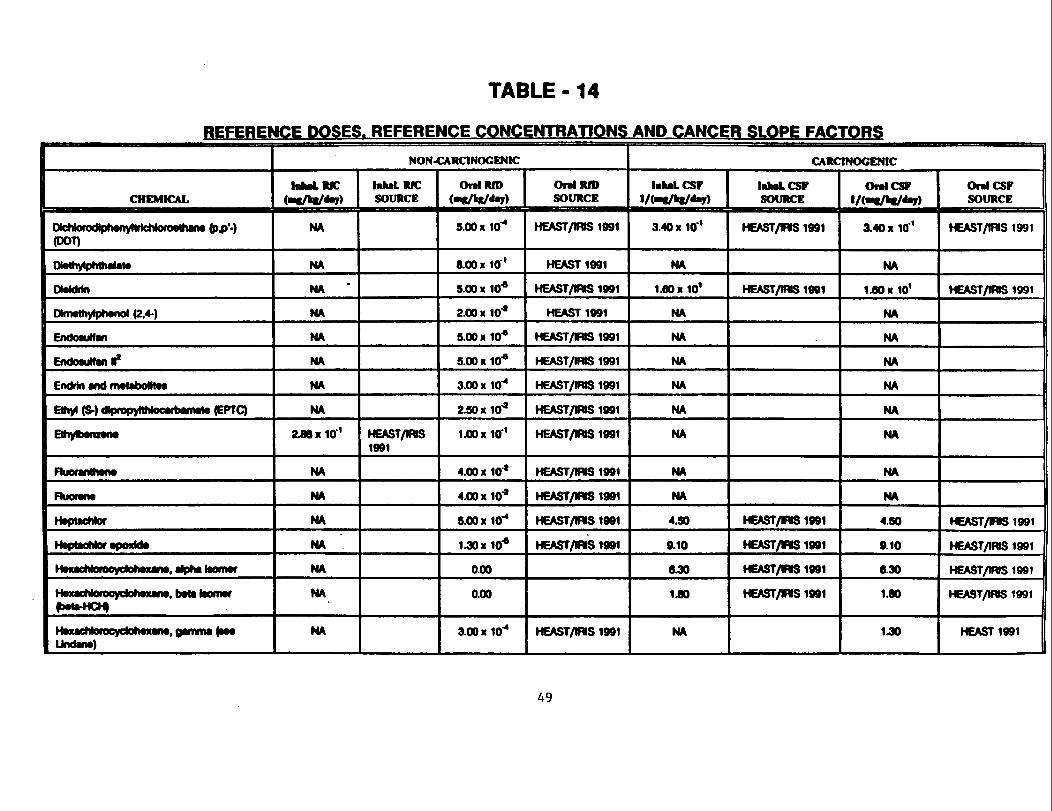
TABLE - 14
REFERENCE DOSES. REFERENCE CONCENTRATIONS AND CANCER SLOPE FACTORS
CHEMICAL
(DOT)
mvuiyifMiu ivittiw
OMdrtn
Dhnrthylphanol (2,4-)
tnootunan
EndosuMan M*Ff*ttttn «mH IBI -* -*- —••*— —
Eihyl (S-) dlpropyNMocarbamata (EPIC)
Ethyftwnzww
rilfOfMIUMIIV
FHlOfWM
Htptachtor
t^Atf^^rf^^LfW aWWftvb^A
HnuchloraeyelohMcaiM, alpha toonMr
(b*ta-HCH)
I MMACiNOfOcycion jiWM! Qaniffla paaUndww)
NON-CARCINOGENIC
lalMLRIC(«l/k|/*9)
NA
NA
NA
NA
NA
NA
NA
NA
2J8X10'1
NA
NA
NA
NA
NA
NA
NA
MttLRICSOURCE
HEAST/nS1991
OnlRID(•iK/kg/fty)
5.00 KlO"*
8.00 x 10 '
5.00x10*
2.00 x 10"*
5.00x10*
5.00 x 10*
3.00 xur*2.50 X 10*
I.OOxlO1
4.00x10*
4.00 xlO*
5.00x10"*
IJOxlO*
0.00
0.00
3.00x10"*
OnlRfDSOURCE
HEAST/mS 1991
HEAST1991
HEAST/IWS 1991
HEAST1991
HEAST/IWS 1991
HEAST/IWS 1991
HEAST/IRIS 1991
HEAST/IWS 1991
HEAST/IRIS 1991
HEAST/IWS 1991
HEAST/NS 1991
HEAST/IWS 1991
HEAST/NS1991
HEAST/IWS 1991
CARCINOGENIC
hhaLCSFlA-^/fct/^y)
3.40 x 10 '
NA
1.80x10*
NA
NA
NA
NA
NA
NA
NA
NA
4.50
9.10
6.30
1JO
NA
lalMLCSTSOURCE
HEAST/IWS 1991
HEAST/IWS 1991
HEAST/WS 1991
HEAST/MS1991
HEAST/WS 1991
HEAST/WS 1991
OralCSF1/(«C>«/ )
3.40 x 10 1
NA
1.60x10'
NA
NA
NA
NA
NA
NA
NA
NA
4.50
9.10
6.30
1.80
1.30
OralCSFSOURCE
HEAST/IWS 1991
HEAST/IWS 1991
HEAST/IWS 1991
HEAST/IWS 1991
HEAST/WS 1991
HEAST/WS 1991
HEAST1991
A9
TABLE - 14
REFERENCE DOSES. REFERENCE CONCENTRATIONS AND CANCER SLOPE FACTORS
CHEMICAL
lnd>no(1 ,2^3)pyraM
Mtthyl «thyl kcton* (MEK) - 2-butanon*
Methyl taobutyt kttofw
Methytoot chkxkfr » Otchkxom«than«
Molta*.
•J- ••§>•>• alMjiarwprnrwMnv
P»butat*
PtMflOl
PyrwM
2.4.5-T
TokMfM - Toluol
TricMoretMnnn* (1.2,4-)
TrichtonwftMM (1,1.1-)
IfamiilalaWfnoww
Xytoim
NON-CARCINOGENIC
iMlMLUC(mtM*J)
NA
NA
9.00x10*
2.00x10''
8.60x10'
NA
NA
NA
NA
NA
NA
NA
5.71 x Iff1
3.00 KlO*1
3.00x10''
NA
8.60 x10'2
lahaLRICSOURCE
HEAST1991
HEAST1991
HEAST1991
HEAST1991
HEAST1901
HEAST1991
HEAST1991
Oral RID(MK/kS/d )
0.00
5.00 X Iff9
5.00 x 10*
5.00 x 10*1
6.00 x 10*
2.00 x 10*
4.00 x 10*
5.00 x 10 *
6.00x10''
3.00 x 10*
1.00 x 104
1.00x10"*
2.00 x 10 '
1.31 x 10*
0.00 x 10 2
1.00 x 10*
2.00
Oral RIDSOURCE
HEAST/mS 1991
HEAST1991
HEAST1991
HEAST/mS 1991
HEAST/mS 1991
HEAST1991
HEAST1991
HEAST/mS 1991
HEAST/IHS 1991
HEAST/mS1991
HEAST/WS1991
HEAST/lfVS 1991
HEAST1991
HEAST1991
HEAST1991
HEAST/IRIS 1991
CARONOCENIC
lakatCSFl/(«I/»t/*V)
6.10 x 10''
NA
NA
NA
1.65x10*
NA
NA
NA
NA
NA
NA
1.82 x 10*
NA
NA
NA
NA
NA
MMLCSrSOURCE
HEAST1991(BaPTEF)
HEAST1991
HEAST1991
OnlCSFl/di /kt/Av)
5JO xlO'1
NA
NA
NA
7.50 x 10*
NA
NA
NA
NA
NA
NA
5.10x10*
NA
NA
NA
NA
NA
OralCSPSOURCE
HEAST1991(BtPTEF)
HEAST1991
HEAST1991
50
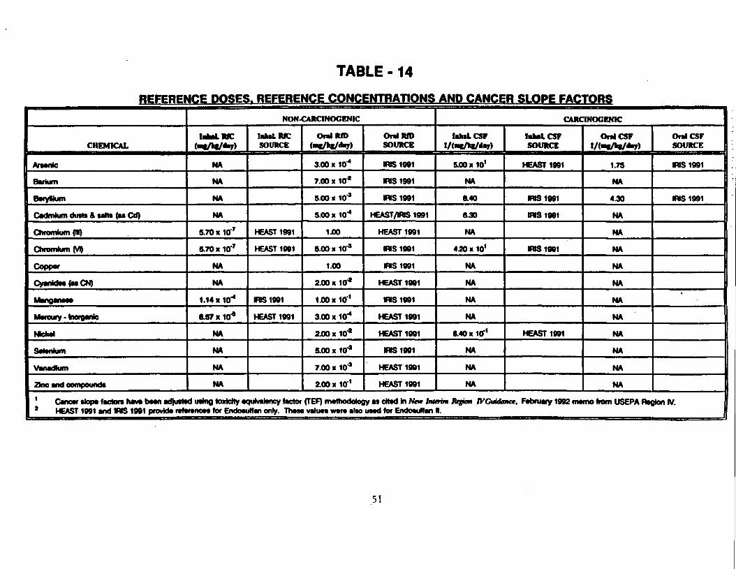
TABLE - 14
REFERENCE DOSES. REFERENCE CONCENTRATIONS AND CANCER SLOPE FACTORS
CHEMICAL
Araante
Barium
BwyWum
Cadmium dutta & salt* faa Cd)
Chromium (ID)
Chromium (VI)
Copper
Cyanidaa (as CN)
Mangaitaaa
Morcufy • InorQMio^•« ,* _•racHw
SowniiMi)
VaVUKMuni
2no and compounds
NON-CARCINOGENIC
lakaLRJC(a /ki/aay)
NA
NA
NA
NA
5.70 K 10 T
5.70K10T*
NA
NA
1.14 x 10"*
8.57 x 10⁴
NA
NA
NA
NA
2 HEAST 1991 and IWS 1991 provida rafaranoaa for Endow
lidMLMCSOURCE
HEAST 1991
HEAST 1991
IRIS 1991
HEAST 1991
pjtatency factorrifan only. Th«ai
OralRfD(MC/ht/daj)
3.00 x 10"*
7.00 x 10*
5.00 x 10""
5.00 x 10*
1.00
5.00 x 10*
1.00
2.00 x 10*
1.00X10'1
3.00 x 10~*
2.00 x 10*
5.00x10*
7.00 x 10*
2.00 x 10 '
Oral RIDSOURCE
IRIS 1991
IRIS1991
IRIS 1991
HEAST/WS1991
HEAST 1991
IWS1991
IWS1991
HEAST 1991
IRIS 1991
HEAST 1991
HEAST 1991
MS 1991
HEAST 1991
HEAST 1991
i vahiM w«ra alto uaad for EndoauN an
CARCINOGENIC
lakaLCSFi/(*«/i«/*r>
5.00 x 10*
NA
8.40
6.30
NA
4^0 x 101
NA
NA
NA
NA
8.40 x 10'1
NA
NA
NA
lakaLCSFSOURCE
HEAST 1991
KVS1991
IRIS 1991
WS1981
HEAST 1991
OralCSFl/(«aVfc«/*>7)
1.75
NA
4.30
NA
NA
NA
NA
NA
NA
NA
NA
NA
NA
NA
OralCSFSOURCE
WS1991
RVS1991
'
•rim Rtftm JVGtiidatct, Fabruary 1992 mamo from USEPA Ragton IV.R.
51
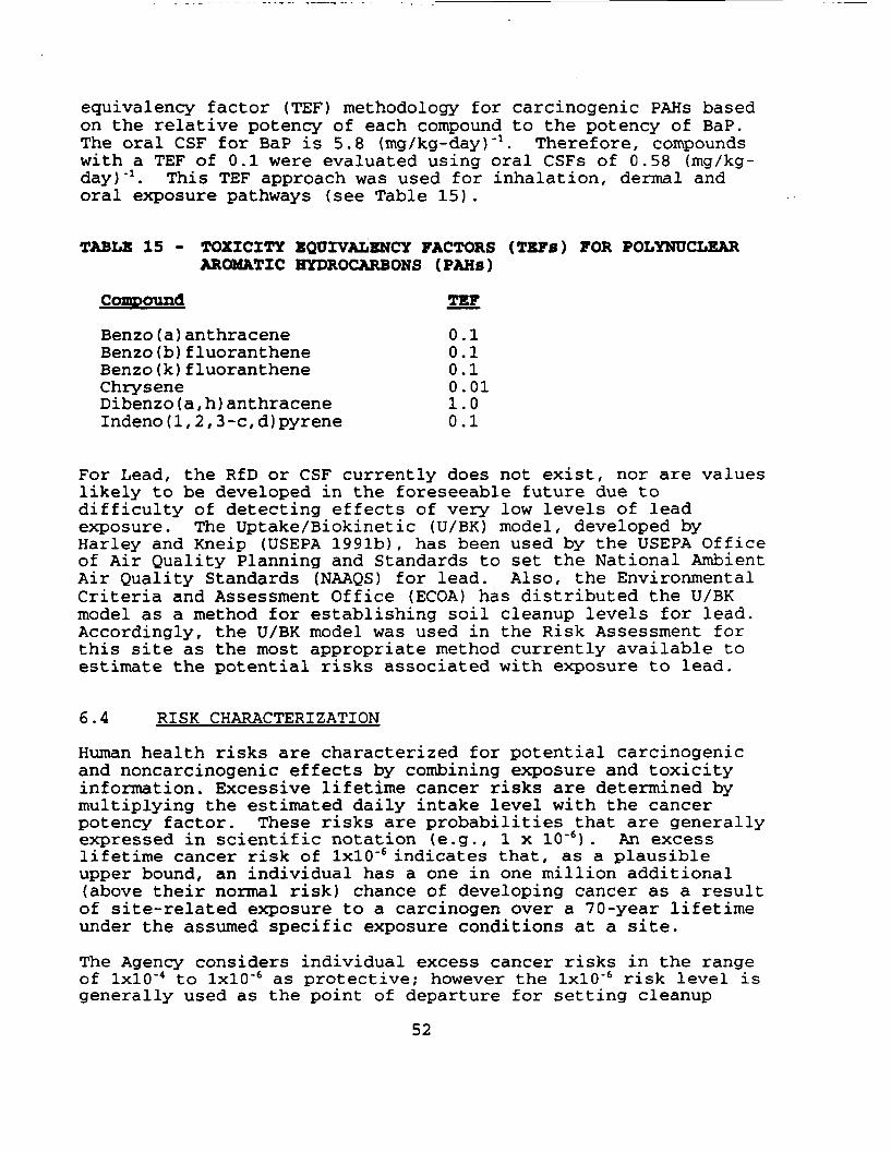
equivalency factor (TEF) methodology for carcinogenic PAHs basedon the relative potency of each compound to the potency of BaP.The oral CSF for BaP is 5.8 (mg/kg-day) "a. Therefore, compoundswith a TEF of 0.1 were evaluated using oral CSFs of 0.58 (mg/kg-day)"1. This TEF approach was used for inhalation, dermal andoral exposure pathways (see Table 15).
TABLE 15 - TOXICITY EQUIVALENCY FACTORS (TEF0) FOR POLYNUCLEARAROMATIC HYDROCARBONS (FAHs)
Compound TEF
Benzo(a)anthracene 0.1Benzo(b)fluoranthene 0.1Benzo(k)fluoranthene 0.1Chrysene 0.01Dibenzo(a,h)anthracene 1.0Indeno(l,2,3-c,d)pyrene 0.1
For Lead, the RfD or CSF currently does not exist, nor are valueslikely to be developed in the foreseeable future due todifficulty of detecting effects of very low levels of leadexposure. The Uptake/Biokinetic (U/BK) model, developed byHarley and Kneip (USEPA 1991b), has been used by the USEPA Officeof Air Quality Planning and Standards to set the National AmbientAir Quality Standards (NAAQS) for lead. Also, the EnvironmentalCriteria and Assessment Office (ECOA) has distributed the U/BKmodel as a method for establishing soil cleanup levels for lead.Accordingly, the U/BK model was used in the Risk Assessment forthis site as the most appropriate method currently available toestimate the potential risks associated with exposure to lead.
6.4 RISK CHARACTERIZATION
Human health risks are characterized for potential carcinogenicand noncarcinogenic effects by combining exposure and toxicityinformation. Excessive lifetime cancer risks are determined bymultiplying the estimated daily intake level with the cancerpotency factor. These risks are probabilities that are generallyexpressed in scientific notation (e.g., 1 x 10'6) . An excesslifetime cancer risk of IxlO"6indicates that, as a plausibleupper bound, an individual has a one in one million additional(above their normal risk) chance of developing cancer as a resultof site-related exposure to a carcinogen over a 70-year lifetimeunder the assumed specific exposure conditions at a site.
The Agency considers individual excess cancer risks in the rangeof IxlO'4 to IxlO"6 as protective; however the IxlO'6 risk level isgenerally used as the point of departure for setting cleanup
52
levels at Superfund sites. The point of departure risk level ofIxlO'6 expresses EPA's preference for remedial actions thatresult in risks at the more protective end of the risk range.
Potential concern for noncarcinogenic effects of a singlecontaminant in a single medium is expressed as the hazardquotient (HQ) (or the ratio of the estimated intake derived fromthe contaminant concentration in a given medium to thecontaminants's reference dose). A HQ which exceeds one (1)indicates that the daily intake from a scenario exceeds thechemical's reference dose. By adding the HQs for allcontaminants within a medium or across all media to which a givenpopulation may reasonably be exposed, the Hazard Index (HI) canbe generated. The HI provides a useful reference point forgauging the potential significance of multiple contaminantexposures within a single medium or across media. An HI whichexceeds unity indicates there may be a concern for potentialhealth effects resulting from the cumulative exposure to multiplecontaminants within a single medium or across media. Tables 16and 17 provide a summary of specific carcinogenic andnoncarcinogenic risks respectively. The future potentialexposure to the surficial and/or alluvial aquifer were the onlypathways which represent an unacceptable risk.
6.5 UNCERTAINTY ANALYSIS
Throughout the risk assessment process, uncertainties associatedwith evaluation of chemical toxicity and potential exposuresarise. For example, uncertainties arise in derivation oftoxicity values for reference doses (RfDs) and carcinogenic slopefactors (CSFs), estimation of exposure point concentrations,fate and transport modeling, exposure assumptions and ecologicaltoxicity data. Because of the conservative nature of the riskassessment process, risks estimated in this assessment are likelyto be overestimates of the true risk associated with potentialexposure at the Redwing Site.
Because of the uncertainty in the calculation of the total areaoccupied by seeps, three different estimations of seep area wereconducted in the risk assessment. This was done to quantify therange of possible exposure and the resulting risks at the RedwingSite. These calculations are presented in the RME scenario(Section 6.2.3.4) of the RI Report and in Appendix XVII of theReport.
Since 1985, a seep inspection and removal program has beenimplemented at the Redwing Site. As a result, seeps have notbeen observed to increase in size beyond approximately 2 inchesin diameter. However, the risk assessment was conducted toevaluate risks associated under the conditions that would occurat the Redwing Site if the removal actions were not occurring.
53
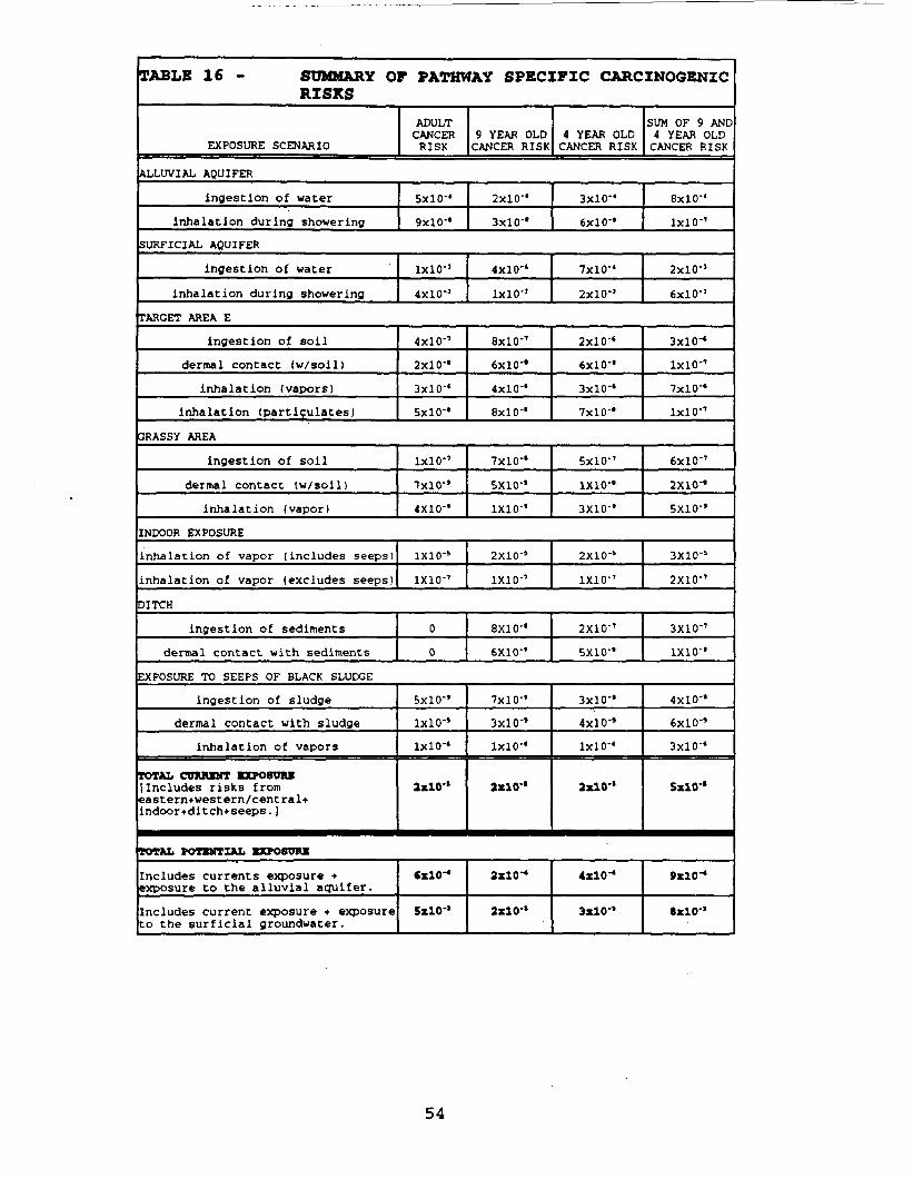
TABLE 16 - SUMMARY OF PATHWAY SPECIFIC CARCINOGENICRISKS
EXPOSURE SCENARIO
ADULTCANCERRISK
9 YEAR OLDCANCER RISK
4 YEAR OLDCANCER RISK
SUM OF 9 AND4 YEAR OLDCANCER RISK
ALLUVIAL AQUIFER
ingestion of water
inhalation during showering
SURFICIAL AQUIFER
ingestion of water
inhalation during showering
SxlO'4
9x10-'
IXlO'1
4x10°
2x10"'
3x10''
4X10'4
IxlO'3
3x10-'
6x10-'
7xlO'4
2X10"
TARGET AREA E
ingestion of soil
dermal contact (w/soil)
inhalation (vapors)
inhalation (partiqulates)
3RASSY AREA
ingestion of soil
dermal contact (w/soll)
inhalation (vapor)
4x10-'
2x10-'
3x10''
5x10''
8x10''
6x10-'
4x10-'
8x10''
2x10''
6x10-'
3x10-'
7x10-'
8xlO'4
1x10-'
2x10"'
6x1 0'J
3x10"
1x10"'
7x10-'
1x10-'
1x10''
7x10'*
4X10"'
7x10-*
5X10-'
ixio-'
5x10"
ixio-'3X10"'
6x10-'
2X10-'
5X10"'
INDOOR EXPOSURE
inhalation of vapor (includes seeps)
inhalation of vapor (excludes seeps)
DITCH
ingestion of sediments
dermal contact with sediments
EXPOSURE TO SEEPS OF BLACK SLUDGE
ingestion of sludge
dermal contact with sludgeinhalation of vapors
TOTAL COHUMT EXPOSURE[Includes risks fromeastern+west em/central*indoor+ditch+seeps. )
TOTAL POTENTIAL EXPOSURE
Includes currents exposure +exposure to the alluvial aquifer.
Includes current exposure + exposureto the surficial groundwater.
IXIO-5
ixio-'
0
0
5x10"'
1x10-'
1x1 0'«
2x10-*
6x10-*
5x10"
2X10⁻⁵
1X10"'
8X10-*
6X10-'
7x10''
3x10"'
1x10-'
2x10-'
2x10-*
2x10-'
2X10⁻⁵
ixio-'
2X10-'
5X10-'
3x10-'
4x10-'
1x10-'
2x10-'
4xlO-«
3x10-*
3X10⁻⁵
2X10-'
3X10-'
ixio-'
4x10-'
6xlO'»
3x10"'
SxlO'*
9xlO-«
8x10"
54
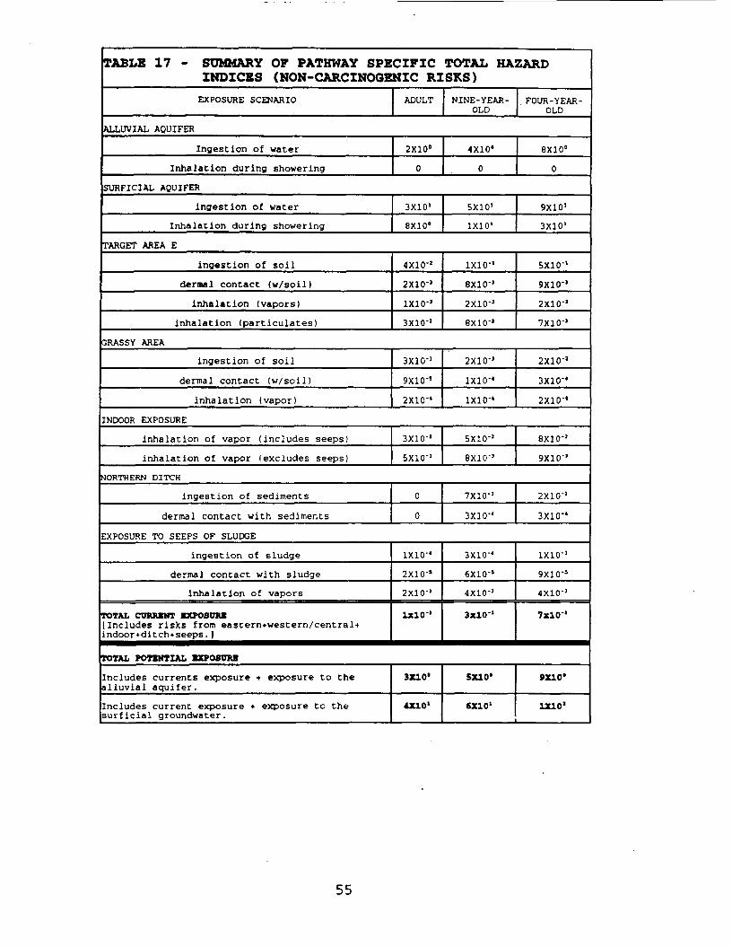
TABLE 17 - SUMMARY OF PATHWAY SPECIFIC TOTAL HAZARDINDICES (NON-CARCINOGENIC RISKS)EXPOSURE SCENARIO
ALLUVIAL AQUIFER
Ingestion of water
Inhalation during showering
ADULT
2X10°
0
NINE-YEAR-OLD
4X10°
0
FOUR-YEAR-OLD
8X10°
0
SURFICIAL AQUIFER
ingest ion of water
Inhalation during showering
3X101
8X10"
TARGET AREA E
ingestion of soil
dermal contact (w/soil)
inhalation (vapors)
inhalation (particulates)
4X10-'
2X10°
ixio-'3X10'1
5X101
mo19X10'
3X10'
1X10'1
8X10'5
2X10-J
8X10"'
5X10-'
9X10"
2X10"'
7X10'1
GRASSY AREA
ingestion of soil
dermal contact (w/soil)
inhalation (vapor)
INDOOR EXPOSURE
inhalation of vapor (includes seeps)
inhalation of vapor (excludes seeps)
3X10"
9X10'5
2X10'4
3X10-'
5X10°
2X10-'
IXIO'4
1X10'4
5X10-'
8X10-'
2X10"'
3X10'4
2X10"
8X10'!
9X10"'
NORTHERN DITCH
ingestion of sediments
dermal contact with sediments
0
0
7X10'1
3X10'4
EXPOSURE TO SEEPS OF SLUDGE
ingestion of sludge
dermal contact with sludge
inhalation of vapors
TOTAL CURRENT EXPOSUREIncludes risks from eastern+western/central+,ndoor+ditch4seeps. ]
TOTAL POTBHTZAL EXPOSURE
Includes currents exposure + exposure to thealluvial aquifer.
Includes current exposure + exposure to thesurficial groundwater.
ixio-'2X10'5
2X10'J
1x10-'
3X10*
4X10'
3X10"
6X10'S
4X10-'
3X10'1
5X10*
fiXlO1
2X10-'
3X10'4
1X10°
9X10'5
4X10''
7X10'1
9X10*
1X10'
55
An alternative seep analysis was conducted assuming a maximumpossible seep area of 10,400 ft2. This is 20 times greater thanthe area used in the RME scenario. Using the alternative seepanalysis, His for the 9 and 4-year-old children exceed 1. Thealternative seep area also increased carcinogenic risks under thecurrent exposure scenario by an order of magnitude.
6.6 HUMAN HEALTH SUMMARY
EPA evaluated present and possible future exposure from 1)surficial and alluvial groundwater, 2) soils and seeps of sludge,3) air and (4) site surface water and sediments. The riskassessment indicates that contaminant levels in surface soil,sediments and sludge seeps are not high enough to pose asignificant health threat via current exposure. Furthermore,there is no current exposure to people from groundwater orsubsurface soil contamination. However, COCs could pose a futurehealth risk if the surficial aquifer were used as a source ofpotable water or if contamination moves into the alluvialaquifer. Additionally, COCs may pose a health risk if the PAHsdetected under the concrete liner become exposed because of theremoval of the liner, or if similar contamination is foundelsewhere along the drainage pathway. The COCs in the northernditch do not currently present a significant human health threat.
6.7 ENVIRONMENTAL EVALUATION
The environmental evaluation examined the potential for adverseecological impacts as a result of the presence of the chemicalsat the Redwing Site. The evaluation was conducted in four steps:(1) identification of the presence of critical habitats andspecies of concern, (2) identification of chemicals of potentialconcern, (3) estimation of acute and chronic toxicity andexposure concentrations, and (4) comparison of toxicity thresholdestimates and exposure estimates.
The ecological risk assessment primarily addressed risk to on-site receptors. The Redwing Site is mostly a non-vegetated, non-aquatic habitat in an urban/residential area and does not provideany special or unique habitats. Therefore, it is unlikely toattract or support endangered or threatened species. Terrestrial(land) plants are limited to mowed grass and a few bushes andtrees. Animals likely to be found at the Redwing Site are songor field birds, small rodents, frogs, and possibly reptiles.Although Redwing Site contaminants might have harmful effects onsome plants and animals, the source area is presently coveredwith soil making direct exposure unlikely. Wildlife wouldprobably avoid the tar seeps. Therefore, the source materialdoes not appear to pose an environmental risk.
56
Site ditches provide only temporary habitats for aquatic plantsand animals. Two aquatic species, the arrowhead plant and themosquitofish, were observed in the concrete-lined ditchesfollowing heavy rainfall. The mosquitofish would likely movedownstream as water in the ditch dries up. Since contaminants inunlined ditch sediments could move downstream and those in thelined ditch could have moved in the past, data from on-site ditchsediments were used to predict effects on plant and animal lifein downstream surface water bodies. The analysis indicated thatthe highest contaminant concentrations were found under theconcrete liner in the ditch and measurable levels of contaminantsare not presently moving off site. Dilution factors were appliedto the maximum detected ditch sediment concentrations todetermine possible sediment contaminant levels downstream inNorton Creek resulting from any past migration. Comparison ofthese levels with toxicity information indicated that possiblepast migration of sediment contaminants downstream into NortonCreek would have little effect on the aquatic biota.
For specific information on EPA's environmental and human healthevaluations, refer to the Baseline Risk Assessment portion of theRI Report.
6.7.1 UNCERTAINTY ANALYSIS
The major uncertainties associated with the environmentalevaluation are the extrapolation of soil/ditch sedimentconcentrations to actual exposures. In addition theextrapolation of laboratory toxicity data on pure compounds orspecific complexes to the Redwing Site, where the actualenvironmental forms are unknown, adds to the uncertainty.
6.8 RISK ASSESSMENT SUMMARY
The health risk posed at this site is primarily from the futureuse of the groundwater in both the surficial and alluvial aquiferas a potable source. This is due to the presence of contaminantspresently at concentrations above EPA's Maximum ContainmentLevels for drinking water. Surface soils and sediments aresubject to contamination from the continual leaching ofcontaminants from the sludge which percolates to the surface.
With regard to environmental risks, there are no permanent on-site aquatic habitats and the only on-site surface water bodiesare intermittent ditches. The highest sediment contaminantlevels are under the lined ditch and therefore not presentlyavailable to migrate along the surface water pathway. Dilutionfactors, with respect to possible effects on aquatic biota onsurface water bodies downstream, show that there would be noadverse effect on aquatic biota from sediment contaminant levels.
57
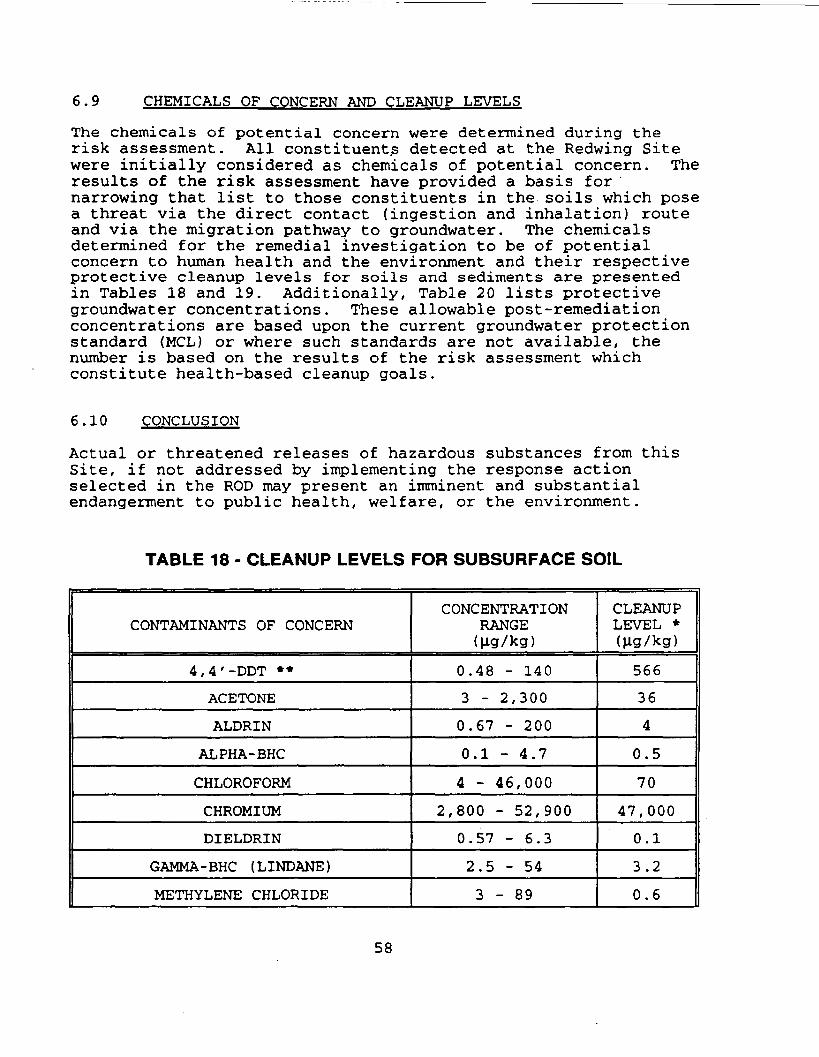
6.9 CHEMICALS OF CONCERN AND CLEANUP LEVELS
The chemicals of potential concern were determined during therisk assessment. All constituents detected at the Redwing Sitewere initially considered as chemicals of potential concern. Theresults of the risk assessment have provided a basis fornarrowing that list to those constituents in the soils which posea threat via the direct contact (ingestion and inhalation) routeand via the migration pathway to groundwater. The chemicalsdetermined for the remedial investigation to be of potentialconcern to human health and the environment and their respectiveprotective cleanup levels for soils and sediments are presentedin Tables 18 and 19. Additionally, Table 20 lists protectivegroundwater concentrations. These allowable post-remediationconcentrations are based upon the current groundwater protectionstandard (MCL) or where such standards are not available, thenumber is based on the results of the risk assessment whichconstitute health-based cleanup goals.
6.10 CONCLUSION
Actual or threatened releases of hazardous substances from thisSite, if not addressed by implementing the response actionselected in the ROD may present an imminent and substantialendangerment to public health, welfare, or the environment.
TABLE 18 - CLEANUP LEVELS FOR SUBSURFACE SOIL
CONTAMINANTS OF CONCERN
4,4'-DDT **
ACETONE
ALDRIN
ALPHA-BHC
CHLOROFORM
CHROMIUM
DIELDRIN
GAMMA-BHC (LINDANE)
METHYLENE CHLORIDE
CONCENTRATIONRANGE(Jig/kg)
0.48 - 140
3 - 2,300
0.67 - 200
0.1 - 4.7
4 - 46,000
2,800 - 52,900
0.57 - 6.3
2.5 - 54
3 - 8 9
CLEANUPLEVEL *(jig/kg)
566
36
4
0.5
70
47,000
0.1
3.2
0.6
58
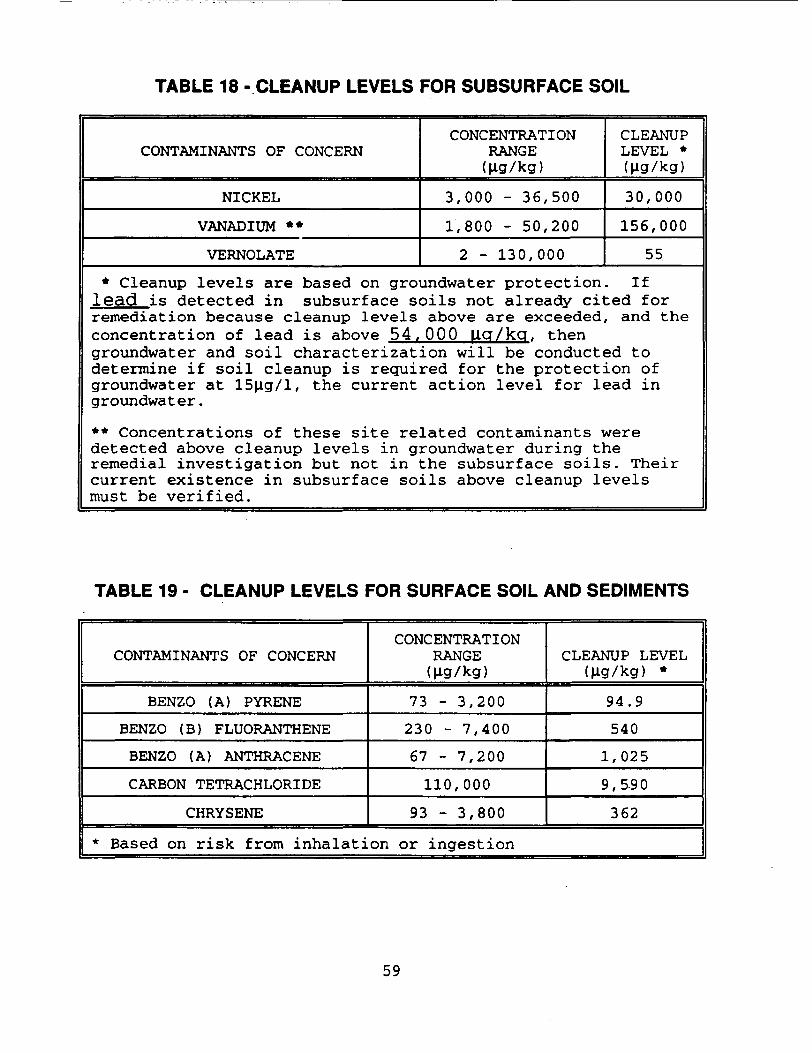
TABLE 18 -CLEANUP LEVELS FOR SUBSURFACE SOIL
CONTAMINANTS OF CONCERN
NICKEL
VANADIUM **
VERNOLATE
CONCENTRATIONRANGE(Hg/kg)
3,000 - 36,500
1,800 - 50,200
2 - 130,000
CLEANUPLEVEL *(Jig/kg)
30,000
156,00055
* Cleanup levels are based on groundwater protection. Iflead is detected in subsurface soils not already cited forremediation because cleanup levels above are exceeded, and theconcentration of lead is above 54, OOP jiq/kq, thengroundwater and soil characterization will be conducted todetermine if soil cleanup is required for the protection ofgroundwater at 15|ig/l, the current action level for lead ingroundwater.
** Concentrations of these site related contaminants weredetected above cleanup levels in groundwater during theremedial investigation but not in the subsurface soils. Theircurrent existence in subsurface soils above cleanup levelsmust be verified.
TABLE 19 - CLEANUP LEVELS FOR SURFACE SOIL AND SEDIMENTS
CONTAMINANTS OF CONCERN
BENZO (A) PYRENE
BENZO (B) FLUORANTHENE
BENZO (A) ANTHRACENE
CARBON TETRACHLORIDE
CHRYSENE
CONCENTRATIONRANGE(ug/kg)
73 - 3,200230 - 7,400
67 - 7,200
110,000
93 - 3,800
CLEANUP LEVEL(ug/kg) *
94.9
540
1,025
9,590
362
* Based on risk from inhalation or ingestion
59
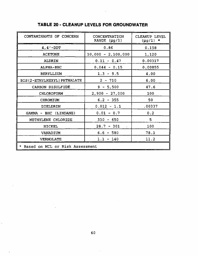
TABLE 20 - CLEANUP LEVELS FOR GROUNDWATER
CONTAMINANTS OF CONCERN
4,4' -DDT
ACETONE
ALDRIN
ALPHA-BHC
BERYLLIUM
BIS (2 -ETHYLHEXYL ) PHTHALATE
CARBON BISULFIDE
CHLOROFORM
CHROMIUM
DIELDRIN
GAMMA - BHC (LINDANE)
METHYLENE CHLORIDE
NICKEL
VANADIUM
VERNOLATE
CONCENTRATIONRANGE (Hg/1)
0.86
10,000 - 2,100,000
0.11 - 0.470.044 - 0.15
1.3 - 9.5
2 - 710
9 - 5,500
2,900 - 27,000
6.2 - 3550.012 - 1.1
0.01 - 0.7
330 - 65028.7 - 301
6.6 - 5801.1 - 140
CLEANUP LEVEL(jig/l) *0.158
1,1200.00317
0.00855
4.00
6.00
47.6
100
50.00337
0.2
5
100
78.1
11.2
* Based on MCL or Risk Assessment
60
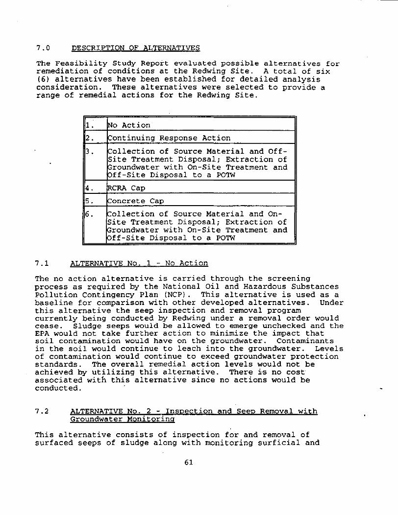
7.0 DESCRIPTION OF ALTERNATIVES
The Feasibility Study Report evaluated possible alternatives forremediation of conditions at the Redwing Site. A total of six(6) alternatives have been established for detailed analysisconsideration. These alternatives were selected to provide arange of remedial actions for the Redwing Site.
1.2.
3.
4.5.
6.
No ActionContinuing Response ActionCollection of Source Material and Off-Site Treatment Disposal; Extraction ofGroundwater with On-Site Treatment andOff-Site Disposal to a POTWRCRA CapConcrete CapCollection of Source Material and On-Site Treatment Disposal; Extraction ofGroundwater with On-Site Treatment andOff-Site Disposal to a POTW
7.1 ALTERNATIVE No. 1 - No Action
The no action alternative is carried through the screeningprocess as required by the National Oil and Hazardous SubstancesPollution Contingency Plan (NCP). This alternative is used as abaseline for comparison with other developed alternatives. Underthis alternative the seep inspection and removal programcurrently being conducted by Redwing under a removal order wouldcease. Sludge seeps would be allowed to emerge unchecked and theEPA would not take further action to minimize the impact thatsoil contamination would have on the groundwater. Contaminantsin the soil would continue to leach into the groundwater. Levelsof contamination would continue to exceed groundwater protectionstandards. The overall remedial action levels would not beachieved by utilizing this alternative. There is no costassociated with this alternative since no actions would beconducted.
7.2 ALTERNATIVE No. 2 - Inspection and Seep Removal withGroundwater Monitoring
This alternative consists of inspection for and removal ofsurfaced seeps of sludge along with monitoring surficial and
61
alluvial groundwater quality and movement. This alternativecontains some of the elements currently being conducted under anAdministrative Order by Redwing Carriers, Inc. Groundwaterremediation is not addressed by this alternative. Under thisalternative, institutional controls and natural attenuation ofthe contamination within the surficial and alluvial groundwaterwould be the mechanism to prevent exposure and groundwaterremediation respectively. The estimated costs for thisalternative is $558,000 for the thirty (30) years ofimplementation. However, the timeframe for natural attenuationto occur has not been determined.
7.3 ALTERNATIVE No. 3 - Excavation of Source Material,Extraction of Surficial Groundwater with Off-SiteTreatment and Disposal of each. Groundwater Monitoringof the Alluvial Aquifer.
This alternative involves excavation and transportation of soiland sludge (i.e. source material) to an off-site treatment anddisposal facility. Additionally, extraction and disposal ofcontaminated surficial groundwater would be required.Groundwater monitoring of the alluvial aquifer would beimplemented to assure attenuation of the contaminant levels.Source material and groundwater pre-treatment may be requiredprior to disposal. This may require thermal and biologicaltreatment of soils and groundwater, respectively. Excavatedsubsurface soils may require dewatering and stabilization priorto land disposal. This water will be analyzed andtreated/disposed of in an appropriate manner. Excavation may beaccomplished with or without the removal of buildings orstructures in areas requiring excavation. Currently, there is noevidence that contamination exists under the buildings. However,if contamination is found during the remedial design appropriateaction, which may involve the demolition of some buildings, willbe undertaken. EPA will consult the public before taking thisaction.
The areas of soil and sludge would be excavated. Residents wouldbe temporarily relocated during the period of excavation. Sourcematerials would be moved to a staging area on-site prior to beinghauled off-site. Some of the excavated soils will be removedfrom the saturated zone and will require dewatering. Sidewalkslabs and pavement areas may be contaminated and thus requireremoval. Excavated areas would be backfilled with cleanmaterial. The excavated material would be sorted andcharacterized to determine if treatment is required before landdisposal. If treatment is required it will be conducted off-siteat an approved facility. All excavated soil, source material,sludge, and contaminated debris will be disposed of off-site atan approved facility. It is estimated that the excavation andremoval would be accomplished in 18 months.
62
Alternative 3 also includes extraction and active treatment ofthe surficial groundwater. Under this alternative contaminatedgroundwater would be extracted, treated on-site and discharged tothe POTW or to a nearby surface water body if appropriate limitscan be met. The alluvial groundwater will be monitored to insurethat chemicals of concern decrease to cleanup levels. If naturalattenuation does not progress at a rate to meet cleanup levelswithin the timeframe of active treatment to the surficialaquifer, the remedial design will be modified to include activetreatment of alluvial as well as surficial groundwater.
An installed network of extraction wells and french drains willextract contaminated groundwater from the surficial aquifer foron-site treatment. The treatment system will use a biotreatmentprocess and sand/activated carbon filtration to treat moreheavily contaminated groundwater. After concentrations decreasethe system may be adjusted to reduce the rate of extraction or toa point where only the filtration system is required. Thegroundwater may also contain contaminants which may not beeffectively treated using a biotreatment process. Thesecontaminants may require a supplemental treatment step. Residualconstituents in the biotreatment sludges or spent carbon would bedisposed of off-site at an approved facility.
It is predicted that 12 million gallons of surficial groundwatermust be treated to reduce concentrations to cleanup levels. Thegroundwater cleanup time frame is estimated to be 7 years. Thetime may be shortened by putting nutrients into the surficialaquifer to enhance biodegradation.
This alternative would provide overall protection for any presentor future uses of the property. The estimated implementationtimeframe for this alternative is seven (7) years. The estimatedcost for this alternative is $7,002,562.
7.4 ALTERNATIVE No. 4 - RCRA Cap. Extraction of SurficialGroundwater for On-site Treatment, and GroundwaterMonitoring for the Alluvial Aquifer.
This alternative involves placement of a RCRA cap over theeastern half of the apartment complex, extraction and on-sitetreatment of the surficial groundwater and monitoring of thealluvial aquifer. Construction of the RCRA cap will require thedemolition of approximately six buildings and the capped areawould be fenced. As part of this alternative, the contaminatedsurficial groundwater will be extracted in order to preventfurther migration of contamination. Groundwater will be treatedon-site and subsequently discharged. The integrity of the capwould be maintained indefinitely with monitoring of the surficialand alluvial aquifer. Surficial groundwater extraction andtreatment is expected to reduce contaminant concentrations below
63

cleanup levels within eleven (11) years. The estimated cost forthis alternative is $3,870,460.
7.5 ALTERNATIVE No. 5 - Concrete Cap, Extraction and Off-SiteTreatment and Disposal of Surficial Groundwater andMonitoring of the Alluvial Aquifer.
This alterative consists of the placement of a concrete cap oversections of the eastern half open grassy areas of the RedwingSite, surficial groundwater extraction with off-site treatmentand disposal and monitoring of the groundwater in the alluvialaquifer.
The concrete cap would be constructed without the demolition ofany apartment buildings. The cap could be placed around theexisting apartment units which are in source areas ofcontamination. The cap would be constructed such that itsintegrity can be maintained and upward movement of subsurfacesludge would be inhibited.
The cap would be designed with sufficient thickness and jointimpermeability to control seeps of sludge and potential vaporemissions. The cap would be designed and constructed above gradeover the current ground surface of the Redwing Site such that itwould eliminate migration of sludge around the edges of the cap.The capped area would remain accessible for use by the apartmentresidents. To maintain the existing functional use of theRedwing Site, recreational-use improvements would be incorporatedinto the cap design.
The contaminated surficial groundwater would be extracted andtreated on-site, as necessary, for disposal to the POTW.Implementation of groundwater monitoring of the alluvial aquiferand maintenance of the cap would be required. The estimatedtimeframe for remediation of the surficial groundwater is ten(10) years. Natural attenuation would be the mechanism forremediation of the alluvial groundwater. The cap would bemaintained indefinitely. The estimated cost of this alternativeis $2,233,751.
7.6 ALTERNATIVE No 6 - Excavation of Source Material andSurficial Groundwater with On-Site Treatment/Disposal.Groundwater Monitoring of the Alluvial Aquifer.
This alternative combines source material excavation with on-sitetreatment of source material and surficial groundwater.Temporary relocation for approximately 2 years would be requiredduring excavation and treatment of the source material.Currently, there is no evidence that contamination exists underthe buildings. However, if contamination is found during the
64
remedial design appropriate action, which may involve thedemolition of some buildings, will be undertaken. EPA willconsult the public before taking this action.
The following primary on-site treatment processes will beimplemented: 1) soil washing/flushing, 2) filtration, and 3)biotreatment. The excavated source material will be stockpiledand washed with a compatible washing agent as a volume reducingtreatment step. The washed soil would be then dewatered andanalyzed before backfilling into the excavation. The spent washsolution and soil fines would be pumped through a filtrationsystem to further separate and concentrate the dissolved andsuspended constituents. The filtrate may be reused as washsolution. The filtered constituents will then be sent to thebiotreatment unit. The biotreatment process will be designed tocreate a favorable environment for microorganisms which arecapable of degrading the compounds of concern at the RedwingSite.
In addition to the soil washing, other technologies (ex-situ soilflushing, gravity separation and ex-situ bioremediation) may alsobe used in addition to or instead of ex-situ soil washing, ifduring the remedial design these technologies are effective inreducing soil contaminant concentrations and are determined to becost effective.
Alternative 6 also includes extraction and active treatment ofsurficial groundwater. Under this alternative, contaminatedgroundwater would be extracted, treated on-site and discharged tothe POTW or to a nearby surface waterbody if appropriate limitscan be met. The alluvial groundwater will be monitored to insurethat chemicals of concern decrease to cleanup levels. If naturalattenuation does not progress at a rate to meet cleanup levelswithin the timeframe of active treatment to the surficialaquifer, the remedial design will be modified to include activetreatment of alluvial as well as surficial groundwater.
An installed network of extraction wells and french drains willextract contaminated groundwater from the surficial aquifer foron-site treatment. The treatment system will use a biotreatmentprocess and sand/activated carbon filtration to treat moreheavily contaminated groundwater. After concentrations decreasethe system may be adjusted to reduce the rate of extraction or toa point where only the filtration system is required. Thegroundwater may also contain contaminants which may not beeffectively treated using a biotreatment process. Thesecontaminants may require a supplemental treatment step. Residualconstituents in the biotreatment sludges or spent carbon would betreated prior to disposal.
It is predicted that 12 million gallons of surficial groundwatermust be treated to reduce concentrations to cleanup levels. The
65
groundwater cleanup time frame is estimated to be 7.1 years. Thetime may be shortened by putting nutrients into the surficialaquifer to enhance biodegradation.
The estimated timeframe for treatment of the source material andgroundwater is 2 and 7 years respectively. The estimated cost ofthis alternative is $6,168,452.
7.7 ARARS AND TBCS
The remedial action for the Redwing Site, under CERCLA Section121 (d), must comply with federal and state environmental lawsthat are either applicable or relevant and appropriate (ARARs).Applicable requirements are those standards, criteria orlimitations promulgated under federal or state law thatspecifically address a hazardous substance, pollutant,contaminant, remedial action, location or other circumstance at aCERCLA site. Relevant and appropriate requirements are thosethat, while not applicable, still address problems or situationssufficiently similar to those encountered at the site that theiruse is well suited to the particular site. To-Be-ConsideredCriteria (TBCs) are non-promulgated advisories and guidance thatare not legally binding but should be considered in determiningthe necessary level of cleanup for protection of health or theenvironment.
While TBCs do not have the status of ARARS, EPA's approach todetermining if a remedial action is protective of human healthand the environment involves consideration of TBCs along withARARs.
The affected groundwater in the aquifers beneath the Redwing Sitehave been classified as Class IIB for the surficial groundwaterand Class IIA for the alluvial aquifer. Class IIB groundwater isa potential drinking water source although the groundwater maynot be currently used as such. Class IIA groundwater is acurrent source of drinking water. It is EPA's policy thatgroundwater resources be protected and restored to theirbeneficial uses. The six remedial alternatives with theexception of alternative one (no action) have components whichmay to some degree promote the beneficial use of the aquifers. Acomplete definition for groundwater classification is provided inthe Guidelines for Ground-water Classification under the EPAGround Water Protection Strategy, Final Draft, December 1986.
The action level for lead in groundwater (IS g) is the only TBCthat has been identified at this time. The potential actionspecific, chemical specific and State ARARs are presented inTables 21A, B and C.
66
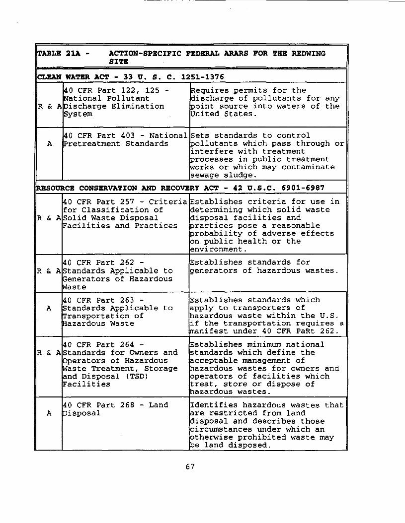
TABLE 21A - ACTION-SPECIFIC FEDERAL ARARS FOR THE REDWINGSITE
CLEAN HATER ACT - 33 U. S. C. 1251-1376
R & A
40 CFR Part 122, 125 •National PollutantDischarge EliminationSystem
Requires permits for thedischarge of pollutants for anypoint source into waters of theUnited States.
40 CFR Part 403 - NationalPretreatment Standards
Sets standards to controlpollutants which pass through orinterfere with treatmentprocesses in public treatmentworks or which may contaminatesewage sludge.
RESOURCE CONSERVATION AND RECOVERY ACT - 42 D.S.C. 6901-6987
R & A
40 CFR Part 257 - Criteriafor Classification ofSolid Waste DisposalFacilities and Practices
Establishes criteria for use indetermining which solid wastedisposal facilities andpractices pose a reasonableprobability of adverse effectson public health or theenvironment.
R & A40 CFR Part 262 -Standards Applicable toGenerators of HazardousWaste
Establishes standards forgenerators of hazardous wastes.
40 CFR Part 263-Standards Applicable toTransportation ofHazardous Waste
Establishes standards whichapply to transporters ofhazardous waste within the U.S.if the transportation requires amanifest under 40 CFR PaRt 262.
R & A40 CFR Part 264 -Standards for Owners andOperators of HazardousWaste Treatment, Storageand Disposal (TSD)Facilities
Establishes minimum nationalstandards which define theacceptable management ofhazardous wastes for owners andoperators of facilities whichtreat, store or dispose ofhazardous wastes.
40 CFR Part 268 - LandDisposal
Identifies hazardous wastes thatare restricted from landdisposal and describes thosecircumstances under which anotherwise prohibited waste maybe land disposed.
67
TABLE 21A - ACTION-SPECIFIC FEDERAL ARARS FOR THE REDWINGSITE
SAFE DRINKING WATER ACT
40 CFR Parts 144 - 147Underground InjectionControl Regulations
Provides for protection ofunderground sources of drinkingwater
HAZARDOUS MATERIALS TRANSPORTATION ACT - 49 U.S. C 1801-181340 CFR Parts 107, 171-177- Hazardous MaterialsTransportation Regulations
Regulates transportation ofhazardous materials.
4 . APPLICABLE REQUIREMENTS WHICH WIRE PROMULGATED UNDER FEDERAL LAW TO SPECIFICALLY ADDRESS A HAZARDOUS SUBSTANCE,POLLUTANT. CONTAMINANT, REMEDIAL ACTION LOCATION OR OTHER CIRCUMSTANCE AT THE REDWJNG STTE.
R * A m RELEVANT AND APPROPRIATE REQUIREMENTS WHICH WHILE THEY ARE NOT "APPLICABLE- TO A HAZARDOUS SUBSTANCE. POLLUTANT,CONTAMINANT. REMEDIAL ACTION, LOCATION, OR OTHER CIRCUMSTANCE AT THE REDWING STTE. ADDRESS PROBLEMS OR SITUATIONS SUFFICIENTLYSIMILAR TO THOSE ENCOUNTERED AT THE REDWING STTE THAT THEIR USE IS WELL SUITED TO THE STTE.
TABLE 21B - CHEMICAL-SPECIFIC FEDERAL ARARS FOR THE REDWINGSITE
CLEAN WATER ACT - 33 U. S. C. 1251-1376
R & A
A
40 CFR Part 131 - AmbientWater Quality Criteriarequirements
40 CFR Part 403 - NationalPretreatment Standards
Suggested ambient standards forthe protection of human healthand aquatic life.
Sets standards to controlpollutants which pass through orinterfere with treatmentprocesses in publicly-ownedtreatment works or which maycontaminate sewage sludge.
RESOURCE CONSERVATION AND RECOVERY ACT - 42 U.S.C. 6901-6987
R & A40 CFR Part 261 -Identification and Listingof Hazardous Wastes
Defines those solid wastes whichare subject to regulation ashazardous wastes under 40 CFRParts 263-265 and Parts 124,270, and 271.
68
TABLE 21B - CHEMICAL-SPECIFIC FEDERAL ARARS FOR THE REDWINGSITE
R & A40 CFR Part 262 -Standards Applicable toGenerators of HazardousWaste
Establishes standards forgenerators of hazardous waste.
CLEAN AIR ACT - 42 USC Section 7401 - 7642
R & A40 CFR Part 50 - NationalPrimary and SecondaryAmbient Air QualityStandards
Establishes standards forambient air quality to protectpublic health and welfare.
SAFE DRINKING HATER ACT - 40 USC Section 300
R & A
R & A
40 CFR Part 141 - NationalPrimary Drinking WaterStandards
PL No. 99-339 100 Stat.462(1986) - MaximumContaminant Level Goals(MCLGs)
Establishes maximum contaminantlevels (MCLs) which are health-based standards for public watersystems.Establishes drinking waterquality goals set at levels ofno known or anticipated adversehealth effects with an adequatemargin of safety.
A . APPLICABLE REQUIREMENTS WHICH WERE PROMULGATED UNDER FEDERAL LAW TO SPECIFICALLY ADDRESS A HAZARDOUS SUBSTANCE.POLLUTANT, CONTAMINANT, REMEDIAL ACTION LOCATION OR OTHER CIRCUMSTANCE AT THE REDWING SITE.
R&A* RELEVANT AND APPROPRIATE REQUIREMENTS WHICH WHILE THEY ARE NOT 'APPLICABLE- TO A HAZARDOUS SUBSTANCE, POLLUTANT,CONTAMINANT, REMEDIAL ACTION, LOCATION, OR OTHER CIRCUMSTANCE AT THE REDWING SITE. ADDRESS PROBLEMS OR SITUATIONS SUFFICIENTLYSIMILAR TO THOSE ENCOUNTERED AT THE REDWING S1TL THAT THEIR USE IS WELL SUITED TO THE SITE.
TABLE 21C -STATE OF ALABAMA ARARS FOR THE REDWING SITE
REGULATION APPLICABLE ORRELEVANT ANDAPPROPRIATE
BASIS FORDETERMINATION
Alabama Water PollutionControl Act code ofAlabama, Title 22,Chapter 22 - WaterImprovement Commission)
APPLICABLE REQUIREMENT WHKH WASPROMULGATED tY THE STATE OFALABAMA TO SPECIFICALLY ADDRESS AHAZARDOUS SUBSTANCE, POLLUTANT,CONTAMINANT, REMEDIAL ACTIONLOCATION OR OTHER CIRCUMSTANCEAT THE REDWING SITE.
Establishesstandards forlimits ofpollution andquality of water.
69
TABLE 21C -STATE OF ALABAMA ARARS FOR THE REDWING SITE
Alabama NationalPollutant DischargeElimination SystemPermit Regulations(Alabama AdministrativeCode, Department ofEnvi ronmen t a1Management, WaterDivision, Water QualityProgram, Chapter 335-6-6 NPDES; adoptedOctober 19, 1979;amended January 24,1989)
APPLICABLE REQUIREMENT WHICH WASPROMULGATED 1Y THE STATE OFALABAMA TO SPECIFICALLY ADDKESS AHAZARDOUS SUBSTANCE, POLLUTANT,CONTAMINANT, REMEDIAL ACTIONLOCATION OR OTHER CIRCUMSTANCEAT THE REDWING STTE.
Stateadministeredpermit programcomparable to theNationalpermittingsystem.
Alabama PrimaryDrinking WaterStandards (AlabamaAdministrative Code,Department ofEnvironmentalManagement, WaterDivision - Water supplyProgram, Chapter 335-7-2-Primary DrinkingWater Standards;Adopted January 4,1989)
APPLICABLE. REQUIREMENT WHICH WASPROMULGATED BY THE STATE OFALABAMA TO SPECIFICALLY ADDRESS AHAZARDOUS SUBSTANCE, POLLUTANT.CONTAMINANT. REMEDIAL ACTIONLOCATION OR OTHER CIRCUMSTANCEAT THE REDWING SITE.
Applicable towater systemsrequired tomonitor forvariouscontaminants.
Maximum Concentrationof Constituents forGroundwater Protection(Alabama AdministrativeCode, Department ofEnvironmentalManagement, HazardousWaste Program, Chapter335-14-5.06-Releasesfrom Solid WasteManagement Units;adopted June 8,m 1983;amended January 25,1992)
RELEVANT AND APPROPRIATEREQUIREMENT WHICH WHILE Tf IS NOT•APPLICABLE • TO A HAZARDOUSSUBSTANCE. POLLUTANT.CONTAMINANT. REMEDIAL ACTION,LOCATION. OR OTHER CIRCUMSTANCEAT THE REDWING STTE, ADDRESSPROBLEMS OR SITUATIONSSUFFICIENTLY SIMILAR TO THOSEENCOUNTERED AT THE REDWING SITETHAT THEK USE IS WELL SUITED TOTHESTTE.
Applies toowners/operatorsof facilitiesthat transport,store, or disposeof hazardouswaste.
8.0 SUMMARY OF COMPARATIVE ANALYSIS OF ALTERNATIVES
This section of the ROD provides the basis for determining which
70
alternative provides the best balance with respect to thestatutory balancing criteria in Section'121 of CERCLA, 42 U.S.C.Section 9621, and in the NCP, 40 C.F.R, Section 300.430. Themajor objective of the FS was to develop, screen and evaluatealternatives for the remediation of the Redwing Site. A widevariety of alternatives and technologies were identified ascandidates to remediate the contamination at the Redwing Site.These were screened based on their feasibility with respect tothe contaminants present and the site characteristics. After theinitial screening, the remaining alternatives/technologies werecombined into potential remedial alternatives and evaluated indetail. The remedial alternative was selected from the screeningprocess using the following nine evaluation criteria:
• Overall protection of human health and the environment;
• Compliance with applicable and/or relevant Federal or Statepublic health or environmental standards;
• Long-term effectiveness and permanence;
• Reduction of toxicity, mobility or volume of hazardoussubstances or contaminants;
• Short-term effectiveness or the impacts a remedy might have onthe community, workers or the environment during the course ofimplementation;
• Implementability, that is, the administrative or technicalcapacity to carry out the alternative;
• Cost-effectiveness considering costs for construction,'operation, and maintenance of the alternative over the life ofthe project, including additional costs should it fail;
• Acceptance by the State and
• Acceptance by the Community.
The NCP categorizes the nine criteria into three groups:
(1) Threshold Criteria - overall protection of human health andthe environment and compliance with ARARs (or invoking awaiver) are threshold criteria that must be satisfied inorder for an alternative to be eligible for selection;
(2) Primary Balancing Criteria - long-term effectiveness andpermanence; reduction of toxicity, mobility or volume;short-term effectiveness; implementability and cost areprimary balancing factors used to weigh major trade-offsamong alternative hazardous waste management strategies; and
71
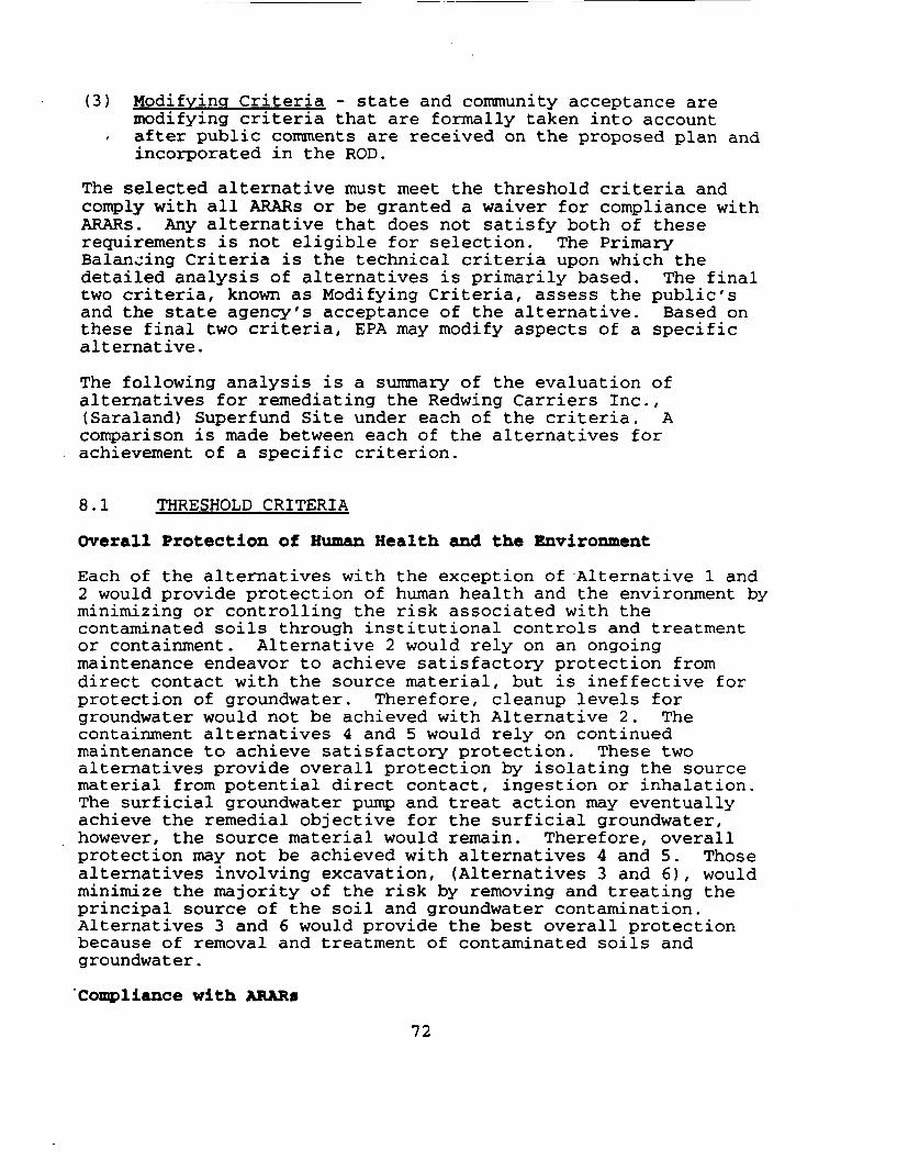
(3) Modifying Criteria - state and community acceptance aremodifying criteria that are formally taken into accountafter public comments are received on the proposed plan andincorporated in the ROD.
The selected alternative must meet the threshold criteria andcomply with all ARARs or be granted a waiver for compliance withARARs. Any alternative that does not satisfy both of theserequirements is not eligible for selection. The PrimaryBalancing Criteria is the technical criteria upon which thedetailed analysis of alternatives is primarily based. The finaltwo criteria, known as Modifying Criteria, assess the public'sand the state agency's acceptance of the alternative. Based onthese final two criteria, EPA may modify aspects of a specificalternative.
The following analysis is a summary of the evaluation ofalternatives for remediating the Redwing Carriers Inc.,(Saraland) Superfund Site under each of the criteria. Acomparison is made between each of the alternatives forachievement of a specific criterion.
8.1 THRESHOLD CRITERIA
Overall Protection of Human Health and the Environment
Each of the alternatives with the exception of Alternative 1 and2 would provide protection of human health and the environment byminimizing or controlling the risk associated with thecontaminated soils through institutional controls and treatmentor containment. Alternative 2 would rely on an ongoingmaintenance endeavor to achieve satisfactory protection fromdirect contact with the source material, but is ineffective forprotection of groundwater. Therefore, cleanup levels forgroundwater would not be achieved with Alternative 2. Thecontainment alternatives 4 and 5 would rely on continuedmaintenance to achieve satisfactory protection. These twoalternatives provide overall protection by isolating the sourcematerial from potential direct contact, ingestion or inhalation.The surficial groundwater pump and treat action may eventuallyachieve the remedial objective for the surficial groundwater,however, the source material would remain. Therefore, overallprotection may not be achieved with alternatives 4 and 5. Thosealternatives involving excavation, (Alternatives 3 and 6), wouldminimize the majority of the risk by removing and treating theprincipal source of the soil and groundwater contamination.Alternatives 3 and 6 would provide the best overall protectionbecause of removal and treatment of contaminated soils andgroundwater.
'Compliance with ARAR0
72
Each of the remaining alternatives (alternatives 3,4, 5 and 6)could comply with all Federal or State ARARs or justify a waiver.Chemical specific ARARs for groundwater would be met throughcompliance with the groundwater protection standards (ie., MCLs).
8.2 PRIMARY BALANCING CRITERIA
Long-Term Effectiveness and Permanence
The long-term effectiveness is demonstrated by treatment ofcontaminated soils and groundwater using proven technologies thuseliminating potential exposure and long term maintenance.
Alternatives 3, 4, 5 and 6 would provide long-term effectivenessthrough limiting the migration of contamination or treatment ofthe contaminated soils at the Redwing Site. For alternatives 4and 5, long-term effectiveness relies on proper cap maintenanceand continued extraction and treatment of groundwater.Implementation would require restricted use of the affectedgroundwater until the remedial cleanup goals are achieved. InAlternative 4, the contaminants are contained on-site in a RCRAlandfill while Alternative 5 uses a concrete cap to preventinfiltration of rainwater into the contaminated soils. Thelong-term effectiveness of Alternative 4 and 5 is satisfactorysince continuous inspection and monitoring would be requiredwhile allowing for the use of the property as an apartmentcomplex. Alternatives 3 and 6 provide the best level oflong-term effectiveness because treatment would be utilized topermanently remediate the soils and groundwater.
Reduction of Toxicity, Mobility or Volume Through Treatment
Alternatives 4 and 5 would isolate the contamination from theenvironment thus minimizing the forces which drive contaminantmobility. However, toxicity and volume would not be affected byAlternative 4 or 5. Alternatives 3 and 6 would reduce themobility, toxicity, and volume of contaminants which are aboveacceptable risk levels.
Short-Term Effectiveness
Alternatives 3, 4, 5 and 6 will require varying amounts of timeto implement. None are immediately implementable or effective.Threshold toxicity criteria would not be exceeded by implementingAlternatives 3 and 6. Health risks to remedial workers isunlikely since appropriate monitoring and engineering controlswill be applied. Of the alternatives evaluated, Alternatives 3and 6 are most effective because contaminated soils andgroundwater would be removed and treated. • However Alternative 6would require a longer implementation time period because of therequirement for on-site treatment, thus reducing its short term
73
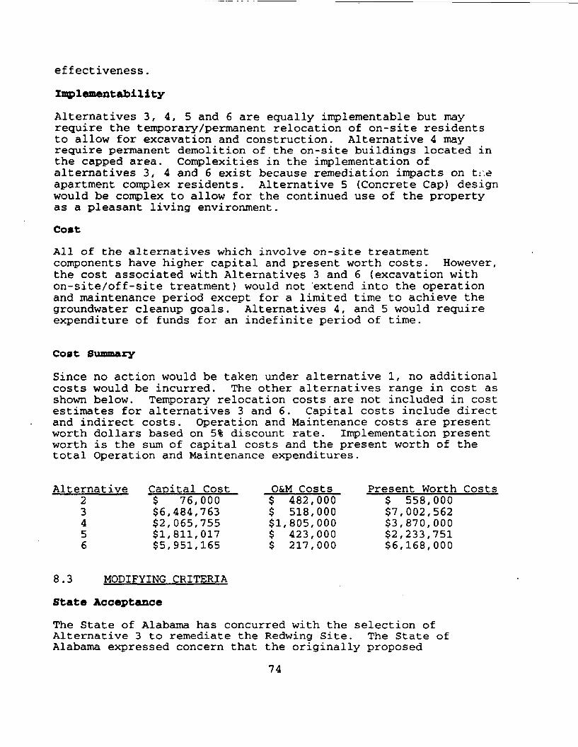
effectiveness.
Implementability
Alternatives 3, 4, 5 and 6 are equally implementable but mayrequire the temporary/permanent relocation of on-site residentsto allow for excavation and construction. Alternative 4 mayrequire permanent demolition of the on-site buildings located inthe capped area. Complexities in the implementation ofalternatives 3, 4 and 6 exist because remediation impacts on t:.eapartment complex residents. Alternative 5 (Concrete Cap) designwould be complex to allow for the continued use of the propertyas a pleasant living environment.
Cost
All of the alternatives which involve on-site treatmentcomponents have higher capital and present worth costs. However,the cost associated with Alternatives 3 and 6 (excavation withon-site/off-site treatment) would not extend into the operationand maintenance period except for a limited time to achieve thegroundwater cleanup goals. Alternatives 4, and 5 would requireexpenditure of funds for an indefinite period of time.
Cost Summary
Since no action would be taken under alternative 1, no additionalcosts would be incurred. The other alternatives range in cost asshown below. Temporary relocation costs are not included in costestimates for alternatives 3 and 6. Capital costs include directand indirect costs. Operation and Maintenance costs are presentworth dollars based on 5% discount rate. Implementation presentworth is the sum of capital costs and the present worth of thetotal Operation and Maintenance expenditures.
Alternative Capital Cost O&M Costs Present Worth Costs2 $ 76,000 $ 482,000 $ 558,0003 $6,484,763 $ 518,000 $7,002,5624 $2,065,755 $1,805,000 $3,870,0005 $1,811,017 $ 423,000 $2,233,7516 $5,951,165 $ 217,000 $6,168,000
8.3 MODIFYING CRITERIA
State Acceptance
The State of Alabama has concurred with the selection ofAlternative 3 to remediate the Redwing Site. The State ofAlabama expressed concern that the originally proposed
74
Alternative 6 would not be the appropriate option for the RedwingSite. EPA took the state agency's concern into account andreevaluated the preferred alternative.
Community Acceptance
At the August 11, 1992 public meeting the primary concernexpressed by the community was that the sludge and contaminatedmaterials be removed from the Redwing Site. Implementation of anoff-site option (Alternative 3) will provide a protectiveremedial alternative and satisfy the primary community concern.
9.0 THE SELECTED REMEDY
Based upon consideration of the requirements of CERCLA, the NCP,the detailed analysis of alternatives and public and statecomments, EPA has selected a source control and groundwaterremedy for this site. The risk associated with this site hasbeen calculated at 10"6 at the completion of this remedy. Thisis determined to be protective of human health and theenvironment. The total present worth cost of the selectedremedy, Alternative #3, is estimated at $7,002,562.
A. Source Control
Source control remediation will address the contaminated soils,sludges and sediments at the Site. Source control shall includeexcavation of soils, sludges and sediments, staging, dewatering,characterization, and transportation to an approved disposalfacility.
A.I. The manor components of source control to be implementedinclude;
Soils, sludges and related materials shall be excavatedat the Redwing Site and staged on-site for off-sitedisposal. Excavation shall occur in all areas of siterelated contamination above cleanup levels. The concreteliners in the southern and eastern ditches shall beremoved and excavation shall occur along past and presentdrainage pathways from the Redwing Site. Excavationshall continue until the remaining soils and sedimentsmaterial achieve the levels specified in the tablesbelow.
In order to comply with ARARs, source material mayrequire pre-treatment prior to disposal. This mayrequire thermal treatment of soils. Excavated subsurfacesoils may require dewatering and stabilization prior toland disposal. The water from the saturated soils mustbe analyzed and treated/disposed of in an appropriate
75
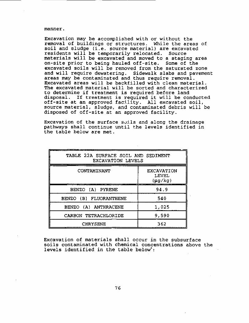
manner.
Excavation may be accomplished with or without theremoval of buildings or structures. While the areas ofsoil and sludge (i.e. source material) are excavatedresidents will be temporarily relocated. Sourcematerials will be excavated and moved to a staging areaon-site prior to being hauled off-site. Some of theexcavated soils will be removed from the saturated zoneand will require dewatering. Sidewalk slabs and pavementareas may be contaminated and thus require removal.Excavated areas will be backfilled with clean material.The excavated material will be sorted and characterizedto determine if treatment is required before landdisposal. If treatment is required it will be conductedoff-site at an approved facility. All excavated soil,source material, sludge, and contaminated debris will bedisposed of off-site at an approved facility.
Excavation of the surface soils and along the drainagepathways shall continue until the levels identified inthe table below are met.
TABLE 22A SURFACE SOIL AND SEDIMENTEXCAVATION LEVELS
CONTAMINANT
BENZO (A) PYRENE
BENZO (B) FLUORANTHENE
BENZO (A) ANTHRACENE
CARBON TETRACHLORIDE
CHRYSENE
EXCAVATIONLEVEL(^g/kg)
94.9
540
1,025
9,590
362
Excavation of materials shall occur in the subsurfacesoils contaminated with chemical concentrations above thelevels identified in the table below*:
76
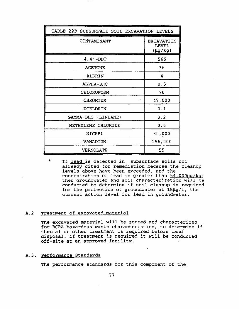
TABLE 22B SUBSURFACE SOIL EXCAVATION LEVELS
CONTAMINANT
4,4' -DDT
ACETONE
ALDRIN
ALPHA-BHC
CHLOROFORM
CHROMIUM
DIELDRIN
GAMMA-BHC (LINDANE)
METHYLENE CHLORIDE
NICKEL
- VANADIUM
-VERNOLATE
EXCAVATIONLEVEL(Hg/kg)
566
36
4
0.5
70
47,000
0.1
3.2
0.6
30,000
156,000
55
If lead is detected in subsurface soils notalready cited for remediation because the cleanuplevels above have been exceeded, and theconcentration of lead is greater than 54.OOOuq/kq;then groundwater and soil characterization will beconducted to determine if soil cleanup is requiredfor the protection of groundwater at 15|J.g/l, thecurrent action level for lead in groundwater.
A.2 Treatment of excavated material
The excavated material will be sorted and characterizedfor RCRA hazardous waste characteristics, to determine ifthermal or other treatment is required before landdisposal. If treatment is required it will be conductedoff-site at an approved facility.
A.3 . Performance Standards
The performance standards for this component of the
77
selected remedy include, but are not limited to, thefollowing excavation and treatment standards:
a. Excavation Standards:
Excavation shall continue until the remaining soil andmaterial achieve the concentration levels identified inTable 22A and 22B of the previous section. Allexcavation shall comply with ARARs, including, but notlimited to OSHA and state standards. Testing methodsapproved by EPA shall be used to determine if theconcentration levels have been achieved.
b. Treatment Standards:
All excavated soils, sludges and related materials willdisposed of at an appropriate approved facility. Pre-treatment may be required prior disposal. Treatmentwill be conducted at an approved facility.
B. Groundwater Remediation
Groundwater remediation will address the contaminated groundwaterat the Redwing Site. Contaminated surficial groundwater will beextracted, treated on-site and discharged to the POTW or to anearby surface waterbody if the POTW is unavailable and ifappropriate limits can be met. The alluvial groundwater will bemonitored to insure that chemicals of concern decrease to cleanuplevels. If natural attenuation does not progress at a rate tomeet cleanup levels within the timeframe of the active treatmentof the surficial groundwater, the remedial design will bemodified to include active treatment of the alluvial aquifer aswell as surficial groundwater.
B.I. The major components of qroundwater remediation to beimplemented include;
Extraction and active treatment of the surficialgroundwater. The major component of groundwaterremediation to be implemented at the Redwing Site isinstallation of a network of extraction wells and frenchdrains to extract contaminated groundwater from thesurficial aquifer for on-site treatment with discharge toa POTW or to a nearby surface waterbody if appropriatelimits can be met.
B.2. Extraction. Treatment, and Discharge of ContaminatedGroundwater
78
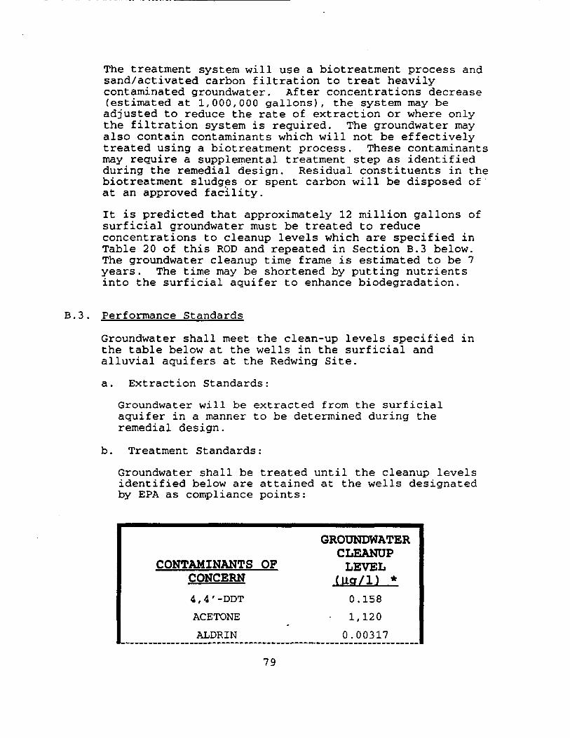
The treatment system will use a biotreatment process andsand/activated carbon filtration to treat heavilycontaminated groundwater. After concentrations decrease(estimated at 1,000,000 gallons), the system may beadjusted to reduce the rate of extraction or where onlythe filtration system is required. The groundwater mayalso contain contaminants which will not be effectivelytreated using a biotreatment process. These contaminantsmay require a supplemental treatment step as identifiedduring the remedial design. Residual constituents in thebiotreatment sludges or spent carbon will be disposed ofat an approved facility.
It is predicted that approximately 12 million gallons ofsurficial groundwater must be treated to reduceconcentrations to cleanup levels which are specified inTable 20 of this ROD and repeated in Section B.3 below.The groundwater cleanup time frame is estimated to be 7years. The time may be shortened by putting nutrientsinto the surficial aquifer to enhance biodegradation.
B.3. Performance Standards
Groundwater shall meet the clean-up levels specified inthe table below at the wells in the surficial andalluvial aquifers at the Redwing Site.
a. Extraction Standards:
Groundwater will be extracted from the surficialaquifer in a manner to be determined during theremedial design.
b. Treatment Standards:
Groundwater shall be treated until the cleanup levelsidentified below are attained at the wells designatedby EPA as compliance points:
CONTAMINANTS OFCONCERN4 ,4 ' -DDT
ACETONE
ALDRIN
GROUNDWATERCLEANUP
LEVEL(UCT/1) *
0.1581,120
0 .00317
79

CONTAMINANTS OFCONCERN
ALPHA-BHC
BERYLLIUMBIS(2-ETHYLHEXYL)PHTHALATE
CARBON BISULFIDE
CHLOROFORM
CHROMIUM
DIELDRIN
GAMMA - BHC (LINDANE)
METHYLENE CHLORIDE
NICKELVANADIUM
VERNOLATE
GROUNDWATERCLEANUP
LEVEL(Ug/1) *
0.00855
4.006.0047.610050
.003370.2
5
10078.111.2
* Based on MCL or Risk Assessment
c. Discharge Standards:
Discharges for the groundwater treatment system shallcomply with all ARARs, including, but not limited to,POTW pretreatment requirements, substantiverequirements of the NPDES permitting program under theClean Water Act, 33 U.S.C Section 1251 et sea.. and alleffluent limits established by EPA.
d. Design Standards:
The design, construction and operation of thegroundwater treatment system shall be conducted inaccordance will all ARARs, including the RCRArequirements set forth in 40 C.F.R. Part 264 (SubpartF) .
C. Compliance Monitoring
Groundwater monitoring shall be conducted at this site on amonthly basis at wells designated by EPA as compliance points.
80
After demonstration of compliance with Performance Standards, theSite including soil and groundwater shall continue to bemonitored quarterly for five years. Inspection of surface soilsfor sludge seeps shall occur not less than monthly during thesummer months of the year. If monitoring indicates that thePerformance Standards set forth in Paragraph B.3 are beingexceeded at any time after pumping has been discontinued,extraction and treatment of the groundwater will recommence untilthe Performance Standards are once again achieved. If monitoringof the remaining soil indicates Performance Standards set forthin Paragraph A.3 have been exceeded, the effectiveness of thesource control component will be re-evaluated.
10.0 STATUTORY DETERMINATIONS
The selected remedy satisfies the requirement of CERCLA section121 to protect human health and the environment by eliminatingand by reducing risks posed through each pathway and populationthrough treatment. The remedy ensures adequate protection ofhuman health and the environment. The site risk will be reducedto the 10"6 risk range for carcinogens, and a Hazard Index fornon-carcinogens of less than one.
No short-term risks or cross-media impacts will be caused byimplementation of the remedy. The selected remedy satisfies therequirement of CERCLA section 121 to comply with ARARS.
The selected remedy provides overall effectiveness proportionateto its costs (i.e., is cost-effective). The selected remedysatisfies the requirement of CERCLA section 121 to utilizepermanent solutions and alternative treatment technologies orresource recovery technologies to the maximum extent practicable.
The selected remedy provides the best balance of tradeoffs amongthe alternatives with respect to the evaluation criteria. Thosecriteria that were most critical in the selection decision (i.e.,those criteria that distinguish the alternatives most) are:Overall protection of human health and the environment,compliance with ARARs; reduction of toxicity, mobility and volumethrough treatment; long term effectiveness and permanence; stateand community acceptance.
11.0 DOCUMENTATION OF SIGNIFICANT CHANGES
Significant changes from the Proposed Plan must be documented inaccordance with CERCLA section 117(b). Although the changes fromthe originally proposed remedial alternative are significant theycould have been reasonably anticipated by the public based on thealternatives and other information available in the proposed planand the supporting analysis and information in the administrative
81
record. Therefore, no additional public comment on the revisedremedial alternative will be offered.
The State of Alabama indicated grave concern about the on-sitetreatment aspect of Alternative 6. This was due to the densityof the population in close proximity to the on-site treatment ofcontaminated soils. The Region evaluated the State's concernswith great scrutiny and agreed that the selection of Alternative3 provided for a better balance between the preference for on-site treatment, and the concerns for the overall negative effc;ton the community. Alternative 3 has therefore been selected asthe final remedial alternative for the Redwing Site.
The soil clean-up levels protective of ground water generated byRedwing Carriers Inc., in the Draft Feasibility Study Report andsubsequently put-forth in the Proposed Plan, were reviewed andrevised. Redwing used the SUMMERS model to generate the levelsand one correction was necessary for each compound. Redwingincorrectly calculated the octanol/water partitioning coefficient(Koc) because they used an equation that is specific to onlycertain compounds. EPA recalculated the soil clean-up levelsusing compound specific Koc values from the EPA publicationentitled Basics of Pump-and-Treat Ground Water RemediationTechnology. Table 18 reflects the results of thesecalculations.
Redwing did not use a site specific partitioning coefficient todetermine the soil cleanup level for lead. It was determinedthat site specific values should be used. EPA performed astatistical analysis of site specific soil/water partitioningcoefficients (Kd's) generated for the site rather than use the Kdthat was used before. The cleanup level which was obtained forlead using this site specific Kd can been specified as an actionlevel for further characterization of soil and groundwater inareas where cleanup levels for other constituents of concern havenot been exceeded.
Although some of the cleanup levels contained in the DraftFeasibility Study were computed incorrectly they were calculatedto achieve the remediation goals which would result in acceptableexposure levels that are protective of human health and theenvironment. The result of EPA's recalculation of the cleanuplevels was that some of the levels became higher while othersbecame lower, however, the final remediation goal remains thesame. In the case of the subsurface soil cleanup levels,protection of the groundwater as a potential drinking watersource is the final remediation goal. A comparison of thecleanup levels from the Draft Feasibility Study and EPA'srecalculated values, is presented below:
82
SOIL CLEAN-UP LEVELS PROTECTIVE OP GROUND WATER(all cleanup levels are in units of ug/kg)
Compound
DDTAcetoneAldrinA-BHCChloroform
ChromiumDieldrinG-BHC (Lindane)Methylene ChlorideNickelVanadiumVernolate
Proposed PlanCleanup Level
1312950.8600.402419
85,8000.09599.409.05
30,300
157,000
56.0
ROD CleanupLevel
5663640.570
47,0000.13.20.6
30,000156,000
55.0
83
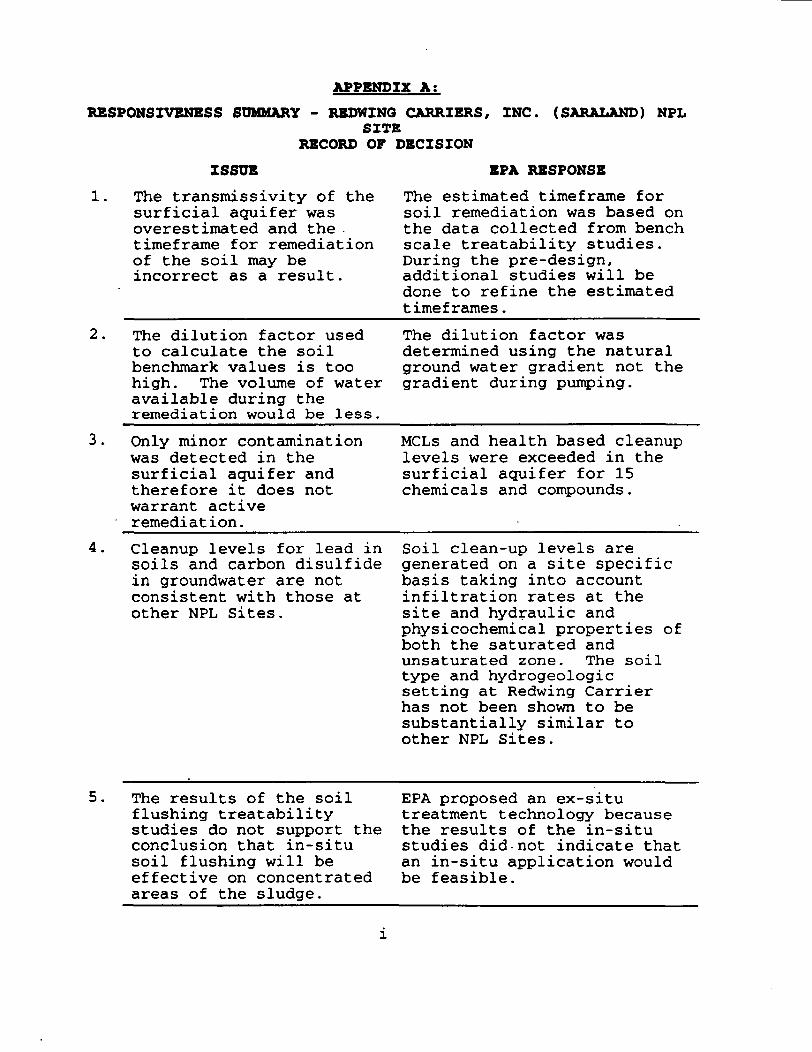
APPENDIX A;
RESPOMSIVENBSS SUMMARY - REDWING CARRIERS, INC. (SARALAND) NPLSITE
RECORD OF DECISION
ISSUE
The transmissivity of thesurficial aquifer wasoverestimated and thetimeframe for remediationof the soil may beincorrect as a result.
EPA RESPONSE
The estimated timeframe forsoil remediation was based onthe data collected from benchscale treatability studies.During the pre-design,additional studies will bedone to refine the estimatedtimeframes.
The dilution factor usedto calculate the soilbenchmark values is toohigh. The volume of wateravailable during theremediation would be less.
The dilution factor wasdetermined using the naturalground water gradient not thegradient during pumping.
Only minor contaminationwas detected in thesurficial aquifer andtherefore it does notwarrant activeremediation.
MCLs and health based cleanuplevels were exceeded in thesurficial aquifer for 15chemicals and compounds.
Cleanup levels for lead insoils and carbon disulfidein groundwater are notconsistent with those atother NPL Sites.
Soil clean-up levels aregenerated on a site specificbasis taking into accountinfiltration rates at thesite and hydraulic andphysicochemical properties ofboth the saturated andunsaturated zone. The soiltype and hydrogeologicsetting at Redwing Carrierhas not been shown to besubstantially similar toother NPL Sites.
5. The results of the soilflushing treatabilitystudies do not support theconclusion that in-situsoil flushing will beeffective on concentratedareas of the sludge.
EPA proposed an ex-situtreatment technology becausethe results of the in-situstudies did-not indicate thatan in-situ application wouldbe feasible.
RESPONSIVENBSS SUMMARY - REDWING CARRIERS, INC. (SARALAND) NPLSITE
RECORD OF DECISION
ISSUE EPA RESPONSE6. Drinking water standards
are not the appropriateground water protectionstandards for thesurficial aquifer at thesite.
Surficial ground water ispresent in adequate supply toprovide water to a privatedwelling.
Past precedents have beenfound to be inappropriate forthe Redwing Site's remedialalternative for clean-up ofsurficial ground water.
Bacterial contamination inthe surficial aquifer can beremoved by disinfectionutilizing routine watertreatment processes.
An investigation of a citedADEM regulations and localwater well installationregulations reveals that thecited regulation would not bean effective institutionalcontrol.
The issue of costs associatedwith use has no pertinence tothe classification of thesurficial aquifer.
The surficial ground watercould be a source of drinkingwater at some point in thefuture. Therefore, drinkingwater standards areappropriate.
7. There has been noconfirmation of thepresence or absence ofcontamination under thebuildings.
The selected remedy providesfor confirmation sampling tofind out if contamination ispresent under the buildings.EPA will present its findingsto the community beforetaking appropriate action toaddress that contamination.
11
RBSPONSIVBNBSS SUMMARY - REDWING CARRIERS, INC. (SARALAND) NPLSITE
RECORD OF DECISION
ISSUE EPA RESPONSE8. People should be moved out
of the buildings nowbecause of the risk posedby possible contaminationunder the buildings.
EPA failed to consider thenegative impact thatrelocation would have onthe community and on thelives of the familiesliving at the apartmentcomplex.
The Baseline Risk Assessmentlooked into the possibilityof harmful vapors moving frombeneath the buildings intothe apartments. Theconclusion was that there isno significant riskassociated with contaminantsunder the buildings.
At the proposed plan publicmeeting a resident askedabout the threat posed to theresidents while the cleanupis occurring. EPA respondedthat portions or the entireproperty would be vacatedwhile the excavation andtreatment of the sourcematerial were occurring.When EPA was asked what wouldhappen to the residents EPAresponded that the specificswould be worked out duringthe design phase. At thattime EPA would inform thepublic which apartments wouldneed to be vacated and atwhich times and for how long.
The risk assessment shouldbe redone.
The risk assessment was donein accordance with EPA'sapproved methods. EPA lookedit various scenarios andevaluated potentialuncertainties associated withthose scenarios.
111
RESPONSIVBMESS SUMMARY - REDWING CARRIERS, INC. (SARALAND) NPLSITE
RECORD OF DECISION
ISSUE BPA RESPONSE
10. Tar-like Material has beenfound coming up off-site.
Information was gathered todetermine a technically soundand imp lenient able remedialoption. During the pre-design, confirmatory samplingwill be conducted todetermine the excavationlimits and to confirm thevolumes of contaminants to becleaned up. All of the dataavailable, including reportsof tar seeps off-site, willbe used to determine theexcavation limits.
11. EPA did not inform ADEM ofthe meeting planned forAugust 10, 1992 with theSaraland Apartmentstenants.
EPA expected the publicmeeting to be dominated byattorneys and worried thatapartment tenants' questionsand concerns regarding thevery personal impact of thecleanup on their lives mightnot have a fair chance to bevoiced in such a forum. Inaddition, EPA felt thatapartment tenants deserved tohear about the proposedcleanup before the generalpublic because of therelocation issue. Therefore,EPA invited all tenants tomeet informally prior to thepublic meeting. Notinviting ADEM was anoversight.
iV
RBSPONSIVEMESS SUMMARY - REDWING CARRIERS, INC. (SARALAND) NPLSITE
RECORD OP DECISION
ISSUE EPA RESPONSE
12. It was stated at thePublic meeting thatsamples were collectedbehind Jones Auto Sales,It was also stated thatVanderbuilt Universitystudents did testing onthe sample.
At the meeting, EPA asked forthe data from the sampling,however, to date EPA has notreceived any furtherinformation regarding thelocation of the samplingevent or the results of theanalysis. ADEM indicatedthat the proprietor deniedthat seeps had been seen onthe property and that he hadno knowledge of the samplingevent. As was stated duringthe Public Meeting, anyinformation regardinglocations where the materialhas been oozing to thesurface could be used torefine the areas which are tobe remediated. If data isproduced from the allegedsampling event or if it isconfirmed that Redwing Sitecontamination is presentbehind Jones Auto Sales, thatinformation will beconsidered in the developmentof the remedial design.
RBSPONSIVENBSS SUMMARY - REDWING CARRIERS, INC. (SARALAND) NPLSITE
RECORD OF DECISIONISSUE EPA RESPONSE
13. In the July 14, 1992 coverletter to the RI Report,the WCM Group mistakenlyindicated that therecently changedcarcinogenic slope factor(CSF) for benzo(a)pyrenewould increase theestimated risks associatedwith that compound.
As EPA indicated at theAugust 11, 1992 publicmeeting (see transcript page33), the affect of the changein the CSF would be to reducethe potency of that compoundby one half. This slightlyreduced the risks associatedwith that compound.
Although the letter from WCMwas included with the FinalRemedial Investigation Report(RI), it referred to aprevious submission of theBaseline Risk Assessment(BRA). The correct value forthe CSF is contained in theBRA Section (Section 6) ofthe RI.
14. The architecturalspecifications referencedin the Draft FeasibilityStudy Report stated thatexcavation of materialsfrom the area in which thebuilding slabs were to belocated would be required.
Adherence to thearchitectural specificationswas not confirmed during theremedial investigation. Thepresence or absence ofcontaminants under buildingswill be confirmed during theremedial design.
VI
RBSPONSXVBNBSS SUMMARY - RKDWINO CARRIERS, INC. (SARALAND) NPLSITE
RECORD OF DECISIONISSUE EPA RESPONSE
15. The presence of thepesticides aldrin anddieldrin in soils at theSite and asphalt are notdifferent than chemicalsfound because of routinepesticide application andin asphalt associated withparking lots and roofshingles.
The presence of the pesticidedieldrin in the soils at theSite was confirmed during theremedial investigation. Itwas also detected in thegroundwater with the highestconcentration being 1.1 ug/1.That concentration is abovethe 10~6 risk based cleanuplevel 0.00337 ug/1. Dieldrinmust be included as aconstituent cited forsubsurface soil for theprotection of groundwater.It must also be cited forgroundwater cleanup. TheProposed Plan did not containdieldrin in Table 3(Preliminary Levels forGroundwater Cleanup).Dieldrin has.been added toTable 20 of the ROD (CleanupLevels For Groundwater).
Redwing Carriers hauledasphalt for Chevron U.S. A.,Inc. (Formerly ChevronAsphalt). Redwing alsohauled sulfuric acid, causticsoda, pesticides, diesel andweedkiller. The tar-likesludge was found to containmany constituents whichprobably resulted from thetanker cleaning operationsand residuals mixing in non-dedicated surfaceimpoundments. This tar-likesludge differs from theasphalt associated withparking lots and roofshingles.
VI1
RBSPONSIVENESS SUMMARY - REDWING CARRIERS, INC. (SARAIAND) NPLSITE
RECORD OF DECISION
ISSUE EPA RESPONSE
16. One commentor suggestedthat Alternative 3 shouldbe selected as the finalremedy for the Site andthat the excavationshould be limited to thethree highly concentratedareas identified in theeastern portion of theSite.
The same commentor alsosuggested that therecharge area createdafter back-filling theexcavations and theinstallation of two wellswould reduce contaminantsto acceptable exposurelevels.
Both Alternatives 3 and 6would eliminate the Siterisks. Alternative 6 was putforth in the proposed planfact sheet because itsatisfies the NationalContingency Plan's (NCP's)preference for on-sitetreatment. Both alternativesare equally protective. Bothalternatives would requiredisplacement of the Siteresidents during excavation.Alternative 3 was estimatedto require 9 to 12 months tocomplete the excavation andback fill. Alternative 6 wasestimated to require 24months for the excavation andtreatment.
The details of the designwill be developed afterconfirmatory sampling hasbeen completed by theselected design contractor.During pre-design, theresults of the confirmatorysampling will be compared tothe cleanup levels identifiedin Tables 18 through 20 ofthe ROD to determine theappropriate excavationlimits.
EPA and ADEM will evaluatethe proposed design of theexcavation and treatmentsystem to ensure that theywill fully and properlyimplement the final remedialalternative.
Vlll
RBSPONSIVENBSS SUMMARY - REDWING CARRIERS, INC. (SARALAND) NPLSITE
RECORD OF DECISION
ISSUE BPA RESPONSE
17. Carbon Tetrachloride wasonly detected once in thesurface soils at the Siteand should be deleted as acontaminant of concern.
Although Carbon Tetrachloridewas only detected once in thesurface soils at the Site,the cleanup level wasselected to achieve a 1 x 10'6risk factor for ingestion anddermal contact. This highlyvolatile contaminant wasfound in the eastern portionof the Site in the children'splayground; therefore, EPAfeels the cleanup level forthis contaminant should beretained.
18 Surficial water table atthe Site cannot reasonablybe viewed as a potentialdrinking water source.
The affected groundwater inthe aquifers beneath theRedwing Site have beenclassified as Class IIB forthe surficial and Class IIAfor the alluvial aquifer.Class IIB groundwater is apotential drinking watersource although thegroundwater may not becurrently used as such.Class IIA groundwater is acurrent source of drinkingwater. It is EPA's policythat groundwater resources beprotected and restored totheir beneficial uses.
19 One commentor requestedthat additional commentson the Proposed Plan beconsidered after EPAdiscloses the basis forchoosing its preferredcleanup alternative.
The basis for EPA's preferredalternative was clearlystated in the Proposed Plan,and at the Proposed Planpublic meeting, and issupported by the RI/FSdocuments. Any newinformation which has notbeen previously consideredwill be considered inaccordance with the NCPduring the RD/RA
IX
RBSPONSIVENESS SUMMARY - REDWING CARRIERS, INC. (SARALAND) NPLSITE
RECORD OF DECISION
ISSUE EPA RESPONSE
20. Site does not pose acurrent threat to healthand the environment.
The current carcinogenicrisks posed by thecontaminants and pathways atthe Redwing Site range from2 x 10'5 to 5 x 1CT5. EPA hasdetermined that, because ofthe current residentialnature of this site, theappropriate point ofdeparture for acceptablecurrent risk is 1 x 10"6.
21 There is no current humanexposure to groundwatercontamination.
Groundwater is a resourcethat must be protected. Thepotential carcinogenic risksposed by the contaminants andpathways at the Redwing Siteinclude exposure to thegroundwater at the site.Risks range from 2 x 10° to 8x 10'5. Additionally MCLshave been exceeded by severalcontaminants related to thesludge and source material atthe site.
22. The Petroleum Exclusionexempts the waste at thissite from being handled byCERCLA.
This site is contaminatedwith, 4,4'-DDT, acetone,aldrin, alpha-BHC, beryllium,bis(2-ethylhexyl)phthalate,carbon disulfide, chloroform,chromium, dieldrin, gamma-BHC(lindane), methylenechloride, nickel, vanadium,vernolate, benzo(a)pyrene,benzo(b)fluoranthene,benzo(a)anthracene, carbontetrachloride, and chrysene.The petroleum exclusion isnot applicable to thesesubstances.
RESPONSZVBNESS SUMMARY - REDWING CARRIERS, INC. (SARALAND) NPLSITE
RECORD OF DECISION
ISSUE EPA RESPONSE
23. Substances at the Site donot pose an environmentalrisk and the statement inthe proposed plan factsheet that ditch sedimentcontamination mav pose aprincipal threat to theenvironment because theymay release contaminationto nearby surface watersis incorrect. The factsheet should be rewrittento correct the issue ofwhether ditch sedimentspose a principalenvironmental threat.
The highest sedimentcontaminant levels are underthe lined ditch and thereforenot available to migratealong the surface waterpathway. Dilution factors,with respect to possibleaffects on aquatic biota onsurface water bodiesdownstream, show that therewould be no adverse affect onaquatic biota from sedimentcontaminant levels.
Principal threat wastes arethose source materialsconsidered to be highly toxicor highly mobile thatgenerally cannot be reliablycontained or would present asignificant risk to humanhealth or the environmentshould exposure occur. Theaffect of the ditch sedimentson the downstream receptorswas incorrectly characterizedas posing a principal threatalong the ecological pathway.The sediment contaminationmav pose a principal threatfrom the human health directcontact pathway shouldexposure occur. Cleanuplevels were developed forcontaminants which weredetected under the concretelined portion of the ditch.
XI
RESPONSZVENBSS SUMMARY - REDWING CARRIERS, INC. (SARALAND) NPLSITE
RECORD OF DECISION
ISSUE EPA RESPONSE
24. Alternative 2 should bethe selected alternative.EPA's contractorrecommended the tar seepsshould continue to beaddressed as they occur.
The no action alternative(Alternative 1) and thecontinuing response action(Alternative 2) would notprovide protection of humanhealth and the environment..Alternative 2 would rely onan ongoing maintenanceendeavor to achievesatisfactory protection fromdirect contact with thesource material, but isineffective for protection ofgroundwater. Therefore,cleanup levels forgroundwater would not beachieved with Alternative 2.Those alternatives involvingexcavation, (Alternatives 3and 6), minimize the majorityof the risk by removing andtreating the principal sourceof the soil and groundwatercontamination. Alternatives3 and 6 provide the bestoverall protection because ofremoval and treatment ofcontaminated soils andgroundwater.
XII
RBSPONSrVENBSS SUMMARY - REDWING CARRIERS, INC. (SARAIAND) NPLSITE
RECORD OF DECISION
ISSUE EPA RESPONSE
25. The Alabama Department ofEnvironmental Managementdisagreed with EPA'spreferred alternative.
The Modifying Criteria (stateand community acceptance) areformally taken into accountafter public comments arereceived on the proposed planand incorporated in the ROD.These assess the public's andthe state agency's acceptanceof the alternative. Based onthese final two criteria, EPAmay modify aspects of aspecific alternative. Afterconsultation with the Stateof Alabama and considerationof the benefits to thecommunity which would begained by implementation ofan off-site option(Alternative 3) which isequally as protective asAlternative 6 (on-sitetreatment), Alternative 3 hasbeen selected as the finalremedial alternative for theRedwing Site.
Xlll
IVLLeigh Pegues. Director
1751 Cong. W.L.Dkkimon DriveMontgomery. AL36130(205)271-7700f AX 271-7950
270-5612
Field Off ices:
110 Vulcan RoadBirmingham. AL35209(205)942-6168FAX 941-1603
P.O. Box 953Decatur. AL35602(205)353-1713FAX 340 9359
2204 Perimeter RoadMobil«. AL36615(205)450-3400FAX 479-2593
ALABAMADEPARTMENT OF ENVIRONMENTAL MANAGEMENT
Guy HuntGovernor
November 30, 1992-7, L- • ft - Rr- j«... .
Mr. Kenneth A. Lucas, RPMU.S. EPA, SSRB345 Courtland St. N.E.Atlanta, GA 30365
Re: Redwing Carriers/Sarland Apartments NPL SiteRecord of Decision
Dear Mr. Lucas:
The Alabama Department of Environmental Management(ADEM), Special Projects, received the second draftRecord of Decision (ROD) for the RedwingCarriers/Saraland Apartments NPL Site on November 6,1992, for review and requested concurrence.
This office appreciates the EPA's consideration ofSTATE concerns expressed in correspondence and at ourSeptember 29, 1992 meeting, with you and Mr. ArthurCollins, here in Montgomery.
The STATE concurs with this ROD, but hasreservations that the selected remedy could be onerousto implement. We reiterate the position thatprotection of human health and the environment couldbe accomplished with a less extensive and disruptivealternative.
Confirmation of the presence or absence of sourcematerial beneath buildings can be ascertained by useof recently developed sensing equipment used in theoil industry and discussed with you.
It is suggested that the clean-up level forMethylene Chloride in subsurface soil and surficialgroundwater may be at or below detection limits.
Page 2Mr. Kenneth A. LucasNovember 30, 1992
In Section 7.3. page 63, 2nd paragraph, thermalpre-treatment of source material and groundwater isnot understood. We see similar language in the dr-ftScope of Work, received Wednesday, November 25, 1932.Applicable air emission standards would have to be metin the use of any thermal device.
Section 9.0 B.. page 80. Groundwater Remediation.calls for discharge of treated water to be dischargedto the POTW or to a nearby surface waterbody. Exceptfor rain events, the closest waterbody is NortonCreek, 1/2 mile from the site.
Please be advised that concurrence with this RODdoes not bind the STATE contractually to matchingrequirements in the event of Fund Lead remediation.If this Lead is followed, the department wouldapproach the Legislature to request funds to meet thefiscal matching requirements concerning this Site.
If there are questions, call this office at(205)260-2787 or 260-2786.
Sincerely,
E. Cooper, ChieSpecial Projects
/JEM/jdb