Embed Size (px)
Citation preview
SUMMARY REPORT ON THE REHABILITATION WORK AT THE 18 “MAJOR” ABANDONED MINERAL EXPLORATION SITES IN NUNAVIK CARRIED OUT
DURING THE SUMMER OF 2010
AND
UPDATE ON THE GENERAL REPONSE PLAN
Kativik Regional Government
Renewable Resources, Environment and Land Use Planning Department
APRIL 2011
2
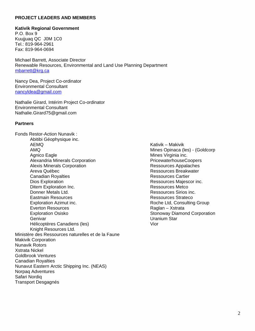
PROJECT LEADERS AND MEMBERS Kativik Regional Government P.O. Box 9 Kuujjuaq QC J0M 1C0 Tel.: 819-964-2961 Fax: 819-964-0694 Michael Barrett, Associate Director Renewable Resources, Environmental and Land Use Planning Department [email protected] Nancy Dea, Project Co-ordinator Environmental Consultant [email protected] Nathalie Girard, Intérim Project Co-ordinator Environmental Consultant [email protected] Partners Fonds Restor-Action Nunavik :
Abitibi Géophysique inc. AEMQ AMQ Agnico Eagle Alexandria Minerals Corporation
Alexis Minerals Corporation Areva Québec Canadian Royalties Dios Exploration Ditem Exploration Inc. Donner Metals Ltd. Eastmain Resources Exploration Azimut inc. Everton Resources Exploration Osisko Genivar Hélicoptères Canadiens (les) Knight Resources Ltd.
Kativik – Makivik Mines Opinaca (les) - (Goldcorp Mines Virginia inc. PricewaterhouseCoopers Ressources Appalaches Ressources Breakwater Ressources Cartier Ressources Majescor inc. Ressources Metco Ressources Sirios inc. Ressources Strateco Roche Ltd, Consulting Group Raglan – Xstrata Stonoway Diamond Corporation Uranium Star Vior
Ministère des Ressources naturelles et de la Faune Makivik Corporation Nunavik Rotors Xstrata Nickel Goldbrook Ventures Canadian Royalties Nunavut Eastern Arctic Shipping Inc. (NEAS) Norpaq Adventures Safari Nordiq Transport Desgagnés
3
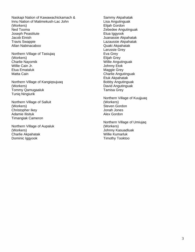
Naskapi Nation of Kawawachickamach & Innu Nation of Matimekush-Lac John (Workers) Ned Tooma Joseph Peastitute Jacob Einish Travis Swappie Allan Nabinacaboo Northern Village of Tasiujaq (Workers) Charlie Nayomik Willie Cain Jr. Etua Emataluk Matta Cain Northern Village of Kangiqsujuaq (Workers) Tommy Qamugaaluk Tuniq Ningiurik Northern Village of Salluit (Workers) Christopher Ikey Adamie Ilisituk Timangiak Cameron Northern Village of Aupaluk (Workers) Charlie Akpahatak Dominic Iggyook
Sammy Akpahatak Lisa Angutinguak Elijah Gordon Zebedee Angutinguak Etua Iggyook Juanassie Akpahatak Lazaussie Akpahatak Quaki Akpahatak Larussie Grey Eva Grey Elijah Grey Willie Angutinguak Johnny Etok Maggie Grey Charlie Angutinguak Etuk Akpahatak Bobby Angutinguak David Angutinguak Tamisa Grey Northern Village of Kuujjuaq (Workers) Steven Gordon Jonah Jones Alex Gordon Northern Village of Umiujaq (Workers) Johnny Kasuadluak Willie Kumarluk Timothy Tooktoo
4
ACKNOWLEDGEMENTS The Kativik Regional Government (KRG) would like to formally acknowledge the Naskapi Nation of Kawawachikamach and the Innu Nation of Matimekush Lac-John for their participation during the fifth and final year of clean-up work at the site KAW-35. A big thank you should also be extended to Norpaq Adventures. Without their support and co-operation, the rehabilitation of the site KAW-35 and would not have been possible. The communities of Tasiujaq and Aupaluk should be recognized for their enormous participation during the fourth year of clean-up work at the site PJ-1. Special thanks go to the Northern Village of Aupaluk and the field technician Charlie Akpahatak, for their year-long dedication to the project and to the crew of the Makivik Corporation’s construction division for their hard work and patience during winter work terms at PJ-1. The KRG would like to acknowledge the communities of Kangiqsujuaq and Salluit for their participation during the third year of clean-up at site SW-34. The environmental division of Xstrata Nickel and the Goldbrook team at Camp Bélanger should also be thanked for their many contributions during the clean-up of this site. The community of Umiujaq extended a helping hand during the clean-up and completion of site WHA-1. The communities of Aupaluk, Tasiujaq and Kuujjuaq need to be thanked for their participation in the clean-up and completion of sites TQ-1 and TQ-4. Mining companies currently active in Nunavik, especially Canadian Royalties, should furthermore be recognized for their clean up initiatives on numerous abandoned mineral exploration sites located on or near their claims.
5
TABLE OF CONTENTS 1 INTRODUCTION ........................................................................................................ 7 2 CONTRIBUTION AGREEMENT ................................................................................. 7 3 DESCRIPTION OF CLEAN-UP WORK UNDERTAKEN IN 2010 ............................... 8
3.1 Labrador Trough .............................................................................................. 11 3.1.1 Kawawachikamach Sector ................................................................... 11 3.1.3. Aupaluk Sector .................................................................................... 24
3.2 Ungava Trough – Hudson Bay ......................................................................... 27 3.2.1. Salluit Sector .......................................................................................... 27 3.2.2 Umiujaq Sector ....................................................................................... 30
4 EXPENDITURES INCCURED DURING 2010 FIELDWORK ................................... 32 5 UPDATE ON GENERAL RESPONSE PLAN ........................................................... 34
5.1 Summer Activities ............................................................................................ 35 5.2 Winter Activities ............................................................................................... 35 5.3 Transportation and Storage of Hazardous Waste ............................................ 36 5.4 Management of Combustible Non-Toxic Material ............................................ 37 5.5 Management of Non-Combustible Non-Toxic Material .................................... 38 5.6 Petroleum-Hydrocarbon Soil Contamination and Acid Mine Drainage ............ 38
6 DESCRIPTION OF CLEAN-UP WORK TO TAKE PLACE IN 2011 ......................... 39 6.1 Ungava Trough – Hudson Bay ......................................................................... 39
6.1.1 Tasiujaq Sector .................................................................................... 39 6.1.2 Salluit Sector ........................................................................................ 40
6.2 Inspections ....................................................................................................... 40 6.3 Community Tour .............................................................................................. 40
7 DRAFT BUDGET FOR 2011 .................................................................................... 42 8 DESCRIPTION OF CLEAN-UP WORK TO BE CARRIED OUT BY MINING COMPANIES 43
8.1 Ungava Trough – Hudson Bay ......................................................................... 43 8.1.1 Salluit Sector ........................................................................................ 43
9 HUMAN RESOURCES ............................................................................................. 47 10 COMMUNICATIONS ................................................................................................ 47 11 REFERENCES ......................................................................................................... 48
APPENDIX 1 .................................................................................................... 49 APPENDIX 2 .................................................................................................... 55 APPENDIX 3 .................................................................................................... 75
6
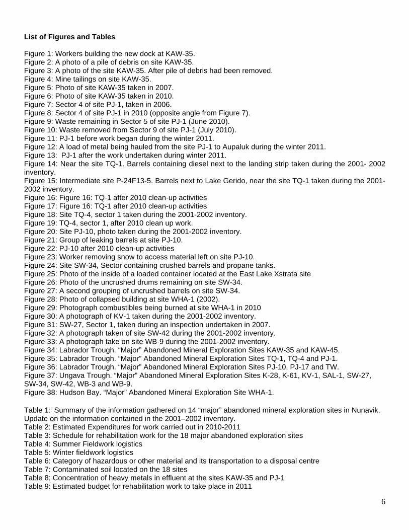
List of Figures and Tables Figure 1: Workers building the new dock at KAW-35. Figure 2: A photo of a pile of debris on site KAW-35. Figure 3: A photo of the site KAW-35. After pile of debris had been removed. Figure 4: Mine tailings on site KAW-35. Figure 5: Photo of site KAW-35 taken in 2007. Figure 6: Photo of site KAW-35 taken in 2010. Figure 7: Sector 4 of site PJ-1, taken in 2006. Figure 8: Sector 4 of site PJ-1 in 2010 (opposite angle from Figure 7). Figure 9: Waste remaining in Sector 5 of site PJ-1 (June 2010). Figure 10: Waste removed from Sector 9 of site PJ-1 (July 2010). Figure 11: PJ-1 before work began during the winter 2011. Figure 12: A load of metal being hauled from the site PJ-1 to Aupaluk during the winter 2011. Figure 13: PJ-1 after the work undertaken during winter 2011. Figure 14: Near the site TQ-1. Barrels containing diesel next to the landing strip taken during the 2001- 2002 inventory. Figure 15: Intermediate site P-24F13-5. Barrels next to Lake Gerido, near the site TQ-1 taken during the 2001-2002 inventory. Figure 16: Figure 16: TQ-1 after 2010 clean-up activities Figure 17: Figure 16: TQ-1 after 2010 clean-up activities Figure 18: Site TQ-4, sector 1 taken during the 2001-2002 inventory. Figure 19: TQ-4, sector 1, after 2010 clean up work. Figure 20: Site PJ-10, photo taken during the 2001-2002 inventory. Figure 21: Group of leaking barrels at site PJ-10. Figure 22: PJ-10 after 2010 clean-up activities Figure 23: Worker removing snow to access material left on site PJ-10. Figure 24: Site SW-34, Sector containing crushed barrels and propane tanks. Figure 25: Photo of the inside of a loaded container located at the East Lake Xstrata site Figure 26: Photo of the uncrushed drums remaining on site SW-34. Figure 27: A second grouping of uncrushed barrels on site SW-34. Figure 28: Photo of collapsed building at site WHA-1 (2002). Figure 29: Photograph combustibles being burned at site WHA-1 in 2010 Figure 30: A photograph of KV-1 taken during the 2001-2002 inventory. Figure 31: SW-27, Sector 1, taken during an inspection undertaken in 2007. Figure 32: A photograph taken of site SW-42 during the 2001-2002 inventory. Figure 33: A photograph take on site WB-9 during the 2001-2002 inventory. Figure 34: Labrador Trough. “Major” Abandoned Mineral Exploration Sites KAW-35 and KAW-45. Figure 35: Labrador Trough. “Major” Abandoned Mineral Exploration Sites TQ-1, TQ-4 and PJ-1. Figure 36: Labrador Trough. “Major” Abandoned Mineral Exploration Sites PJ-10, PJ-17 and TW. Figure 37: Ungava Trough. “Major” Abandoned Mineral Exploration Sites K-28, K-61, KV-1, SAL-1, SW-27, SW-34, SW-42, WB-3 and WB-9. Figure 38: Hudson Bay. “Major” Abandoned Mineral Exploration Site WHA-1. Table 1: Summary of the information gathered on 14 “major” abandoned mineral exploration sites in Nunavik. Update on the information contained in the 2001–2002 inventory. Table 2: Estimated Expenditures for work carried out in 2010-2011 Table 3: Schedule for rehabilitation work for the 18 major abandoned exploration sites Table 4: Summer Fieldwork logistics Table 5: Winter fieldwork logistics Table 6: Category of hazardous or other material and its transportation to a disposal centre Table 7: Contaminated soil located on the 18 sites Table 8: Concentration of heavy metals in effluent at the sites KAW-35 and PJ-1 Table 9: Estimated budget for rehabilitation work to take place in 2011
7
1 INTRODUCTION
In 2001 and 2002, verification of 193 possible abandoned mineral exploration sites was performed in Nunavik, the territory of Québec north of the 55th parallel. The results of that verification are described in the Assessment and Prioritization of Abandoned Mining Exploration Sites in Nunavik: Final Report on a Two-Year Project (2001–2002) produced by the Kativik Regional Government (KRG) and the Makivik Corporation in March 2003. The final report indicates that, of the 193 possible sites, 90 were confirmed to be abandoned mineral exploration camps. Eighteen of these were classified as requiring major clean-up work, 27 needed intermediate clean-up work and 45 would require minor clean-up work. This classification takes into account the quantity of material and equipment present at each site as well as the nature and scope of contaminated soil and surface water. Further to the recommendations derived from the 2001–2002 inventory work and with funding from Environment Canada’s Northern Ecosystem Initiative (NEI) and from the Ministère des Ressources naturelles et de la Faune (Natural Resources and Wildlife, MRNF), in 2005 and 2006 the KRG implemented two rehabilitation pilot projects of “major” abandoned mineral exploration sites, KAW-35 (2005–2006) and PJ-1 (2006). At the same time, Cruise North Expeditions had voluntarily undertaken to clean up a third “major” abandoned mineral exploration site known as PJ-17. These initiatives represent the initial stage of a proposed Nunavik-wide clean-up project. Specifically in August 2003, the KRG and the Makivik Corporation proposed a funding mechanism and recommendations for the assessment and rehabilitation of abandoned mineral exploration sites (Barrett and Lanari, 2003). The proposal focused in particular on the 18 “major” clean-up sites and promoted a partnership between Northern Québec communities, the mining industry and the different levels of government. In March 2007, the mineral industry took up the challenge and created the Fonds Restor-Action Nunavik (FRAN) to rehabilitate abandoned mineral exploration sites in Nunavik dating as far back as several decades. In October 2007, a formal contribution agreement was signed by the KRG, the Makivik Corporation, the MRNF and the FRAN. The agreement has made it possible to proceed with the clean-up of all the 18 “major” sites using the expertise developed during the above-mentioned pilot projects. This report compiles all the information currently available on the 18 “major” clean-up sites. Firstly, this report describes the clean-up work carried out during the 2010 season while providing an overview of the progress of clean-up work since 2005. The seven sites discussed are: KAW-35, PJ-1, PJ-10 TQ-1, TQ-4, SW-34, and WHA-1. Appendix 1 includes five maps that indicate all the 18 major sites in relation to nearby communities (Figures 34-38). Secondly, the report will outline future rehabilitation plans based on the previous work completed and the budget needed to ensure this work is undertaken.
2 CONTRIBUTION AGREEMENT
In October 2007, an agreement concerning the clean-up of abandoned mineral exploration sites in Nunavik was signed by the KRG, Makivik Corporation, the MRNF and FRAN. The purpose of the agreement is to ensure the clean-up of 18 “major” sites, before March 31, 2012. The sites are identified in the Assessment and Prioritization of Abandoned Mining Exploration Sites in Nunavik: Final Report on a Two-Year Project (2001–2002) produced by the KRG and the Makivik Corporation in March 2003. The KRG is responsible for the management of the clean-up work at the 18 sites covered under the agreement. The cost of the 6-year project was estimated at four million, one hundred thousand dollars ($4.1 million). The KRG is also responsible for drafting a timetable and anticipated budget for each year of work. In 2010 the cost of the clean-up work was estimated at approximately eight hundred and fifty six thousand ($856,050). Makivik Corporation contributes to the project by way of in-kind contribution in the form of marine and air transportation services for materials and labour. They are also responsible to ensure that the concerned Inuit communities are adequately informed of the cleanup work to be performed.

8
FRAN participates through financial and in-kind contributions not exceeding seven hundred and fifty thousand ($750,000). In 2010, FRAN reached its maximum financial contribution. The MRNF participates in the project through financial contributions of which the maximum is 4 million, one hundred thousand dollars ($4.1 M).
3 DESCRIPTION OF CLEAN-UP WORK UNDERTAKEN IN 2010
This section provides an updated description of the sites where clean-up work was carried out during the 2010 season. Each site is described individually with supporting figures, while Table 1 provides a summary of the information about each site gathered in 2007. It should be noted that in 2010 a field technician was hired to supervise the work on each of the sites and in some communities when necessary. Charlie Akpahatak, who has been part of the PJ-1 work team during the past 5 years, was hired by KRG to fulfil this role. Nancy Dea remained as project coordinator for most of the 2010 season. In October 2010 she was temporarily replaced by Nathalie Girard while on maternity leave.
9
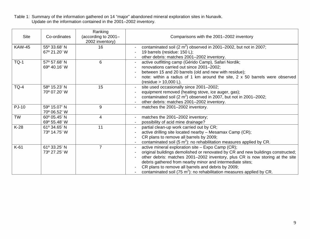
Table 1: Summary of the information gathered on 14 “major” abandoned mineral exploration sites in Nunavik. Update on the information contained in the 2001–2002 inventory.
Site
Co-ordinates Ranking
(according to 2001–2002 inventory)
Comparisons with the 2001–2002 inventory
KAW-45 55º 33.68’ N 67º 21.20’ W
16 - contaminated soil (2 m2) observed in 2001–2002, but not in 2007; - 19 barrels (residue: 150 L); - other debris: matches 2001–2002 inventory.
TQ-1 57º 57.68’ N 69º 40.16’ W
6 - active outfitting camp (Gérido Camp), Safari Nordik; - renovations carried out since 2001–2002; - between 15 and 20 barrels (old and new with residue); - note: within a radius of 1 km around the site, 2 x 50 barrels were observed
(residue > 10,000 L). TQ-4 58º 15.23’ N
70º 07.20’ W 15 - site used occasionally since 2001–2002;
- equipment removed (heating stove, ice auger, gas); - contaminated soil (2 m2) observed in 2007, but not in 2001–2002; - other debris: matches 2001–2002 inventory.
PJ-10 59º 15.07’ N 70º 06.52’ W
9 - matches the 2001–2002 inventory.
TW 60º 05.45’ N 69º 55.48’ W
4 - matches the 2001–2002 inventory; - possibility of acid mine drainage?
K-28 61º 34.65’ N 73º 14.75’ W
11 - partial clean-up work carried out by CR; - active drilling site located nearby – Mesamax Camp (CR); - CR plans to remove all barrels by 2009; - contaminated soil (5 m2): no rehabilitation measures applied by CR.
K-61 61º 33.25’ N 73º 27.25’ W
7 - active mineral exploration site – Expo Camp (CR); - original buildings demolished or renovated by CR and new buildings constructed; - other debris: matches 2001–2002 inventory, plus CR is now storing at the site
debris gathered from nearby minor and intermediate sites; - CR plans to remove all barrels and debris by 2009; - contaminated soil (75 m2): no rehabilitation measures applied by CR.
10
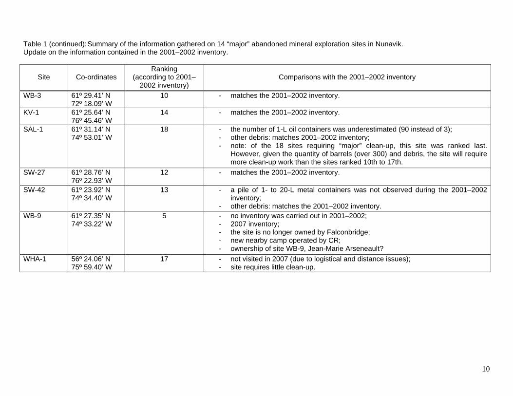
Table 1 (continued): Summary of the information gathered on 14 “major” abandoned mineral exploration sites in Nunavik. Update on the information contained in the 2001–2002 inventory.
Site
Co-ordinates
Ranking (according to 2001–
2002 inventory)
Comparisons with the 2001–2002 inventory
WB-3 61º 29.41’ N 72º 18.09’ W
10 - matches the 2001–2002 inventory.
KV-1 61º 25.64’ N 76º 45.46’ W
14 - matches the 2001–2002 inventory.
SAL-1 61º 31.14’ N 74º 53.01’ W
18 - the number of 1-L oil containers was underestimated (90 instead of 3); - other debris: matches 2001–2002 inventory; - note: of the 18 sites requiring “major” clean-up, this site was ranked last.
However, given the quantity of barrels (over 300) and debris, the site will require more clean-up work than the sites ranked 10th to 17th.
SW-27 61º 28.76’ N 76º 22.93’ W
12 - matches the 2001–2002 inventory.
SW-42 61º 23.92’ N 74º 34.40’ W
13 - a pile of 1- to 20-L metal containers was not observed during the 2001–2002 inventory;
- other debris: matches the 2001–2002 inventory. WB-9 61º 27.35’ N
74º 33.22’ W 5 - no inventory was carried out in 2001–2002;
- 2007 inventory; - the site is no longer owned by Falconbridge; - new nearby camp operated by CR; - ownership of site WB-9, Jean-Marie Arseneault?
WHA-1 56º 24.06’ N 75º 59.40’ W
17 - not visited in 2007 (due to logistical and distance issues); - site requires little clean-up.
11
3.1 Labrador Trough
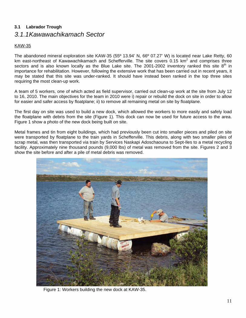
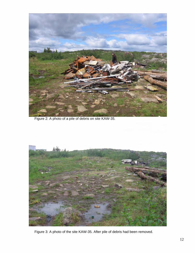
3.1.1 Kawawachikamach Sector KAW-35 The abandoned mineral exploration site KAW-35 (55º 13.94’ N, 66º 07.27’ W) is located near Lake Retty, 60 km east-northeast of Kawawachikamach and Schefferville. The site covers 0.15 km2 and comprises three sectors and is also known locally as the Blue Lake site. The 2001-2002 inventory ranked this site 8th in importance for rehabilitation. However, following the extensive work that has been carried out in recent years, it may be stated that this site was under-ranked. It should have instead been ranked in the top three sites requiring the most clean-up work. A team of 5 workers, one of which acted as field supervisor, carried out clean-up work at the site from July 12 to 16, 2010. The main objectives for the team in 2010 were i) repair or rebuild the dock on site in order to allow for easier and safer access by floatplane; ii) to remove all remaining metal on site by floatplane. The first day on site was used to build a new dock, which allowed the workers to more easily and safely load the floatplane with debris from the site (Figure 1). This dock can now be used for future access to the area. Figure 1 show a photo of the new dock being built on site. Metal frames and tin from eight buildings, which had previously been cut into smaller pieces and piled on site were transported by floatplane to the train yards in Schefferville. This debris, along with two smaller piles of scrap metal, was then transported via train by Services Naskapi Adoschaouna to Sept-Iles to a metal recycling facility. Approximately nine thousand pounds (9,000 lbs) of metal was removed from the site. Figures 2 and 3 show the site before and after a pile of metal debris was removed.
Figure 1: Workers building the new dock at KAW-35.
12
Figure 2: A photo of a pile of debris on site KAW-35.
Figure 3: A photo of the site KAW-35. After pile of debris had been removed.
13
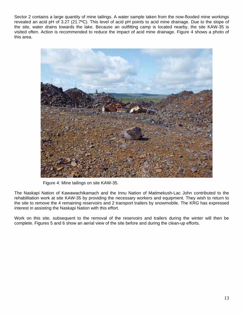
Sector 2 contains a large quantity of mine tailings. A water sample taken from the now-flooded mine workings revealed an acid pH of 3.27 (21.7ºC). This level of acid pH points to acid mine drainage. Due to the slope of the site, water drains towards the lake. Because an outfitting camp is located nearby, the site KAW-35 is visited often. Action is recommended to reduce the impact of acid mine drainage. Figure 4 shows a photo of this area. Figure 4: Mine tailings on site KAW-35. The Naskapi Nation of Kawawachikamach and the Innu Nation of Matimekush-Lac John contributed to the rehabilitation work at site KAW-35 by providing the necessary workers and equipment. They wish to return to the site to remove the 4 remaining reservoirs and 2 transport trailers by snowmobile. The KRG has expressed interest in assisting the Naskapi Nation with this effort. Work on this site, subsequent to the removal of the reservoirs and trailers during the winter will then be complete. Figures 5 and 6 show an aerial view of the site before and during the clean-up efforts.
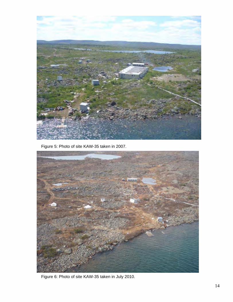
14
Figure 5: Photo of site KAW-35 taken in 2007.
Figure 6: Photo of site KAW-35 taken in July 2010.
15
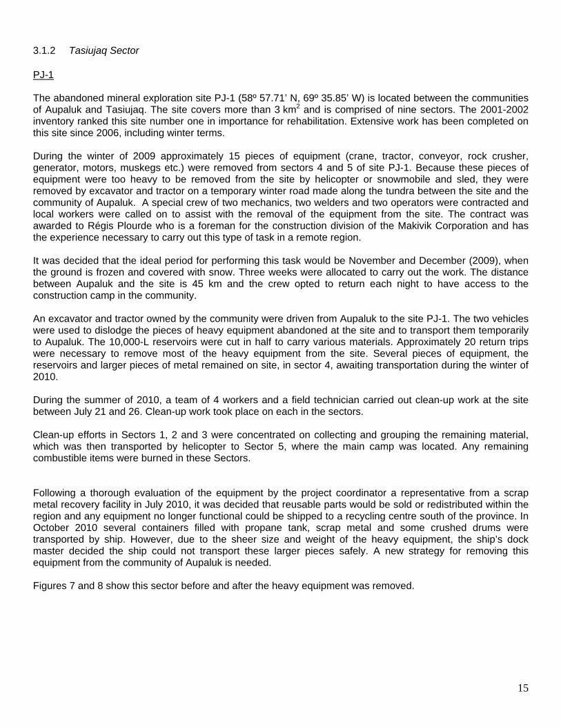
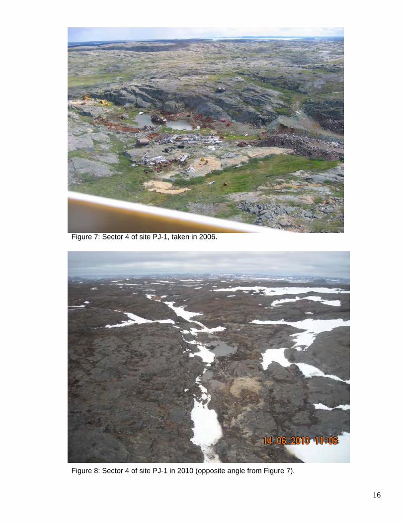
3.1.2 Tasiujaq Sector PJ-1 The abandoned mineral exploration site PJ-1 (58º 57.71’ N, 69º 35.85’ W) is located between the communities of Aupaluk and Tasiujaq. The site covers more than 3 km2 and is comprised of nine sectors. The 2001-2002 inventory ranked this site number one in importance for rehabilitation. Extensive work has been completed on this site since 2006, including winter terms. During the winter of 2009 approximately 15 pieces of equipment (crane, tractor, conveyor, rock crusher, generator, motors, muskegs etc.) were removed from sectors 4 and 5 of site PJ-1. Because these pieces of equipment were too heavy to be removed from the site by helicopter or snowmobile and sled, they were removed by excavator and tractor on a temporary winter road made along the tundra between the site and the community of Aupaluk. A special crew of two mechanics, two welders and two operators were contracted and local workers were called on to assist with the removal of the equipment from the site. The contract was awarded to Régis Plourde who is a foreman for the construction division of the Makivik Corporation and has the experience necessary to carry out this type of task in a remote region. It was decided that the ideal period for performing this task would be November and December (2009), when the ground is frozen and covered with snow. Three weeks were allocated to carry out the work. The distance between Aupaluk and the site is 45 km and the crew opted to return each night to have access to the construction camp in the community. An excavator and tractor owned by the community were driven from Aupaluk to the site PJ-1. The two vehicles were used to dislodge the pieces of heavy equipment abandoned at the site and to transport them temporarily to Aupaluk. The 10,000-L reservoirs were cut in half to carry various materials. Approximately 20 return trips were necessary to remove most of the heavy equipment from the site. Several pieces of equipment, the reservoirs and larger pieces of metal remained on site, in sector 4, awaiting transportation during the winter of 2010. During the summer of 2010, a team of 4 workers and a field technician carried out clean-up work at the site between July 21 and 26. Clean-up work took place on each in the sectors. Clean-up efforts in Sectors 1, 2 and 3 were concentrated on collecting and grouping the remaining material, which was then transported by helicopter to Sector 5, where the main camp was located. Any remaining combustible items were burned in these Sectors. Following a thorough evaluation of the equipment by the project coordinator a representative from a scrap metal recovery facility in July 2010, it was decided that reusable parts would be sold or redistributed within the region and any equipment no longer functional could be shipped to a recycling centre south of the province. In October 2010 several containers filled with propane tank, scrap metal and some crushed drums were transported by ship. However, due to the sheer size and weight of the heavy equipment, the ship’s dock master decided the ship could not transport these larger pieces safely. A new strategy for removing this equipment from the community of Aupaluk is needed. Figures 7 and 8 show this sector before and after the heavy equipment was removed.
16
Figure 7: Sector 4 of site PJ-1, taken in 2006.
Figure 8: Sector 4 of site PJ-1 in 2010 (opposite angle from Figure 7).
17
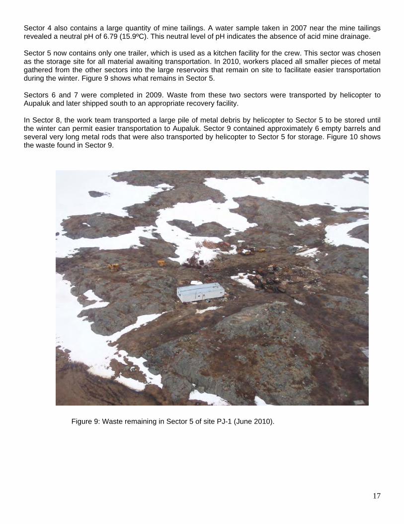
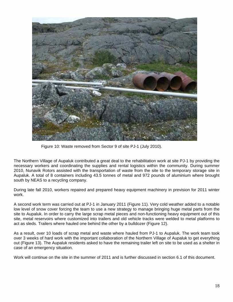
Sector 4 also contains a large quantity of mine tailings. A water sample taken in 2007 near the mine tailings revealed a neutral pH of 6.79 (15.9ºC). This neutral level of pH indicates the absence of acid mine drainage. Sector 5 now contains only one trailer, which is used as a kitchen facility for the crew. This sector was chosen as the storage site for all material awaiting transportation. In 2010, workers placed all smaller pieces of metal gathered from the other sectors into the large reservoirs that remain on site to facilitate easier transportation during the winter. Figure 9 shows what remains in Sector 5. Sectors 6 and 7 were completed in 2009. Waste from these two sectors were transported by helicopter to Aupaluk and later shipped south to an appropriate recovery facility. In Sector 8, the work team transported a large pile of metal debris by helicopter to Sector 5 to be stored until the winter can permit easier transportation to Aupaluk. Sector 9 contained approximately 6 empty barrels and several very long metal rods that were also transported by helicopter to Sector 5 for storage. Figure 10 shows the waste found in Sector 9.
Figure 9: Waste remaining in Sector 5 of site PJ-1 (June 2010).
18
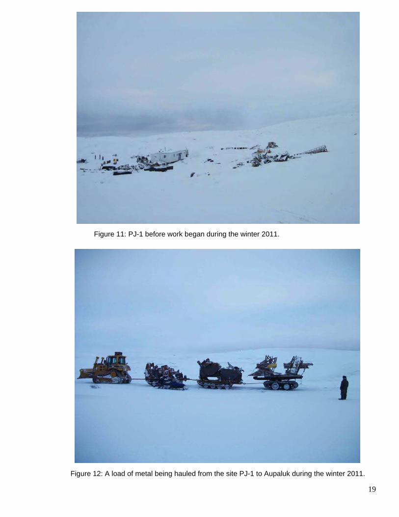
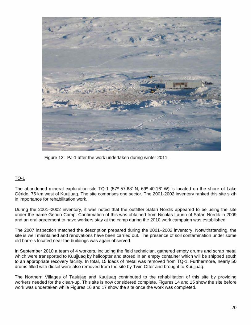
Figure 10: Waste removed from Sector 9 of site PJ-1 (July 2010). The Northern Village of Aupaluk contributed a great deal to the rehabilitation work at site PJ-1 by providing the necessary workers and coordinating the supplies and rental logistics within the community. During summer 2010, Nunavik Rotors assisted with the transportation of waste from the site to the temporary storage site in Aupaluk. A total of 8 containers including 43.5 tonnes of metal and 972 pounds of aluminium where brought south by NEAS to a recycling company. During late fall 2010, workers repaired and prepared heavy equipment machinery in prevision for 2011 winter work. A second work term was carried out at PJ-1 in January 2011 (Figure 11). Very cold weather added to a notable low level of snow cover forcing the team to use a new strategy to manage bringing huge metal parts from the site to Aupaluk. In order to carry the large scrap metal pieces and non-functioning heavy equipment out of this site, metal reservoirs where customized into trailers and old vehicle tracks were welded to metal platforms to act as sleds. Trailers where hauled one behind the other by a bulldozer (Figure 12). As a result, over 10 loads of scrap metal and waste where hauled from PJ-1 to Aupaluk. The work team took over 3 weeks of hard work with the important collaboration of the Northern Village of Aupaluk to get everything out (Figure 13). The Aupaluk residents asked to have the remaining trailer left on site to be used as a shelter in case of an emergency situation. Work will continue on the site in the summer of 2011 and is further discussed in section 6.1 of this document.
19
Figure 11: PJ-1 before work began during the winter 2011.
Figure 12: A load of metal being hauled from the site PJ-1 to Aupaluk during the winter 2011.
20
Figure 13: PJ-1 after the work undertaken during winter 2011.
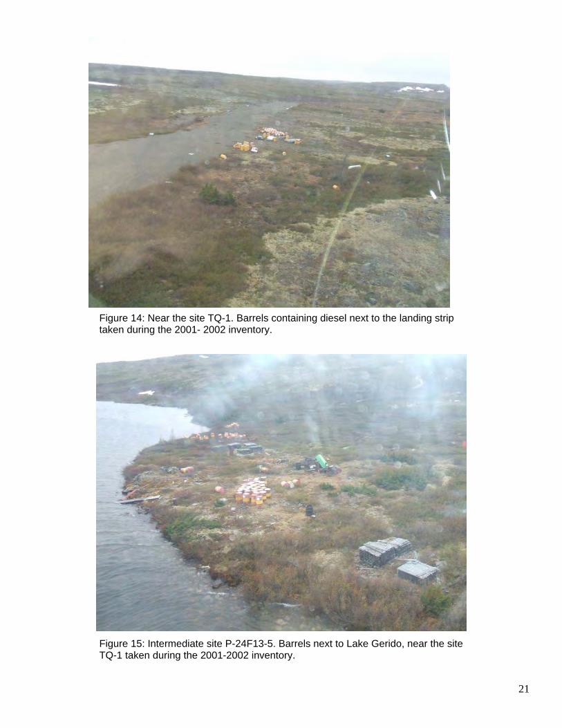
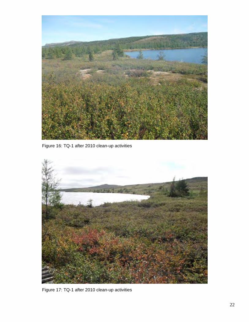
TQ-1 The abandoned mineral exploration site TQ-1 (57º 57.68’ N, 69º 40.16’ W) is located on the shore of Lake Gérido, 75 km west of Kuujjuaq. The site comprises one sector. The 2001-2002 inventory ranked this site sixth in importance for rehabilitation work. During the 2001–2002 inventory, it was noted that the outfitter Safari Nordik appeared to be using the site under the name Gérido Camp. Confirmation of this was obtained from Nicolas Laurin of Safari Nordik in 2009 and an oral agreement to have workers stay at the camp during the 2010 work campaign was established. The 2007 inspection matched the description prepared during the 2001–2002 inventory. Notwithstanding, the site is well maintained and renovations have been carried out. The presence of soil contamination under some old barrels located near the buildings was again observed. In September 2010 a team of 4 workers, including the field technician, gathered empty drums and scrap metal which were transported to Kuujjuaq by helicopter and stored in an empty container which will be shipped south to an appropriate recovery facility. In total, 15 loads of metal was removed from TQ-1. Furthermore, nearly 50 drums filled with diesel were also removed from the site by Twin Otter and brought to Kuujjuaq. The Northern Villages of Tasiujaq and Kuujjuaq contributed to the rehabilitation of this site by providing workers needed for the clean-up. This site is now considered complete. Figures 14 and 15 show the site before work was undertaken while Figures 16 and 17 show the site once the work was completed.
21
Figure 14: Near the site TQ-1. Barrels containing diesel next to the landing strip taken during the 2001- 2002 inventory.
Figure 15: Intermediate site P-24F13-5. Barrels next to Lake Gerido, near the site TQ-1 taken during the 2001-2002 inventory.
22
Figure 16: TQ-1 after 2010 clean-up activities Figure 17: TQ-1 after 2010 clean-up activities
23
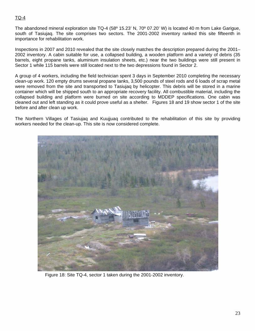
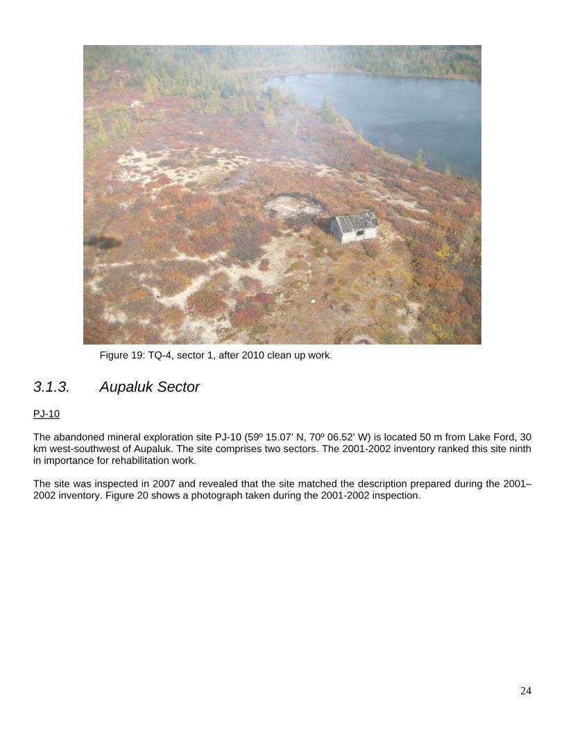
TQ-4 The abandoned mineral exploration site TQ-4 (58º 15.23’ N, 70º 07.20’ W) is located 40 m from Lake Garigue, south of Tasiujaq. The site comprises two sectors. The 2001-2002 inventory ranked this site fifteenth in importance for rehabilitation work. Inspections in 2007 and 2010 revealed that the site closely matches the description prepared during the 2001–2002 inventory. A cabin suitable for use, a collapsed building, a wooden platform and a variety of debris (35 barrels, eight propane tanks, aluminium insulation sheets, etc.) near the two buildings were still present in Sector 1 while 115 barrels were still located next to the two depressions found in Sector 2. A group of 4 workers, including the field technician spent 3 days in September 2010 completing the necessary clean-up work. 120 empty drums several propane tanks, 3,500 pounds of steel rods and 6 loads of scrap metal were removed from the site and transported to Tasiujaq by helicopter. This debris will be stored in a marine container which will be shipped south to an appropriate recovery facility. All combustible material, including the collapsed building and platform were burned on site according to MDDEP specifications. One cabin was cleaned out and left standing as it could prove useful as a shelter. Figures 18 and 19 show sector 1 of the site before and after clean up work. The Northern Villages of Tasiujaq and Kuujjuaq contributed to the rehabilitation of this site by providing workers needed for the clean-up. This site is now considered complete.
Figure 18: Site TQ-4, sector 1 taken during the 2001-2002 inventory.
24
Figure 19: TQ-4, sector 1, after 2010 clean up work.
3.1.3. Aupaluk Sector PJ-10 The abandoned mineral exploration site PJ-10 (59º 15.07’ N, 70º 06.52’ W) is located 50 m from Lake Ford, 30 km west-southwest of Aupaluk. The site comprises two sectors. The 2001-2002 inventory ranked this site ninth in importance for rehabilitation work. The site was inspected in 2007 and revealed that the site matched the description prepared during the 2001–2002 inventory. Figure 20 shows a photograph taken during the 2001-2002 inspection.
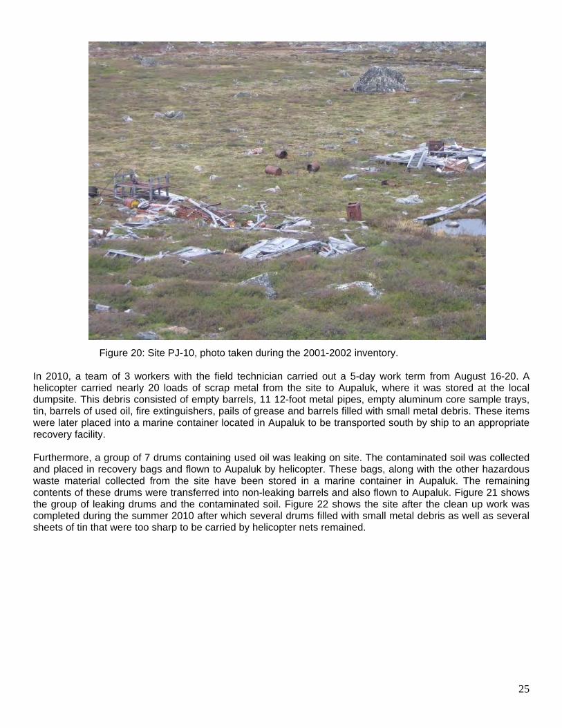
25
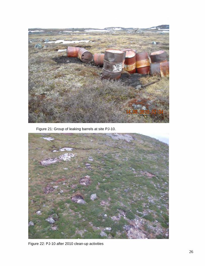
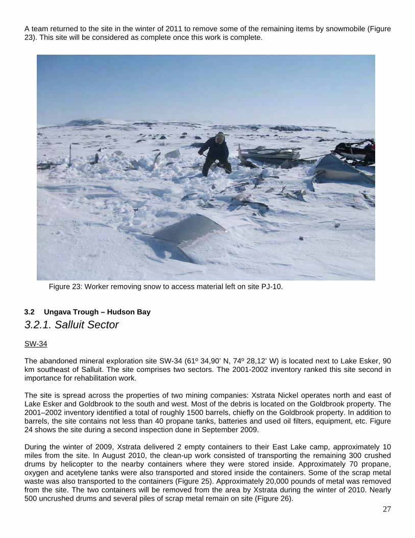
Figure 20: Site PJ-10, photo taken during the 2001-2002 inventory. In 2010, a team of 3 workers with the field technician carried out a 5-day work term from August 16-20. A helicopter carried nearly 20 loads of scrap metal from the site to Aupaluk, where it was stored at the local dumpsite. This debris consisted of empty barrels, 11 12-foot metal pipes, empty aluminum core sample trays, tin, barrels of used oil, fire extinguishers, pails of grease and barrels filled with small metal debris. These items were later placed into a marine container located in Aupaluk to be transported south by ship to an appropriate recovery facility. Furthermore, a group of 7 drums containing used oil was leaking on site. The contaminated soil was collected and placed in recovery bags and flown to Aupaluk by helicopter. These bags, along with the other hazardous waste material collected from the site have been stored in a marine container in Aupaluk. The remaining contents of these drums were transferred into non-leaking barrels and also flown to Aupaluk. Figure 21 shows the group of leaking drums and the contaminated soil. Figure 22 shows the site after the clean up work was completed during the summer 2010 after which several drums filled with small metal debris as well as several sheets of tin that were too sharp to be carried by helicopter nets remained.
26
Figure 21: Group of leaking barrels at site PJ-10.
Figure 22: PJ-10 after 2010 clean-up activities
27
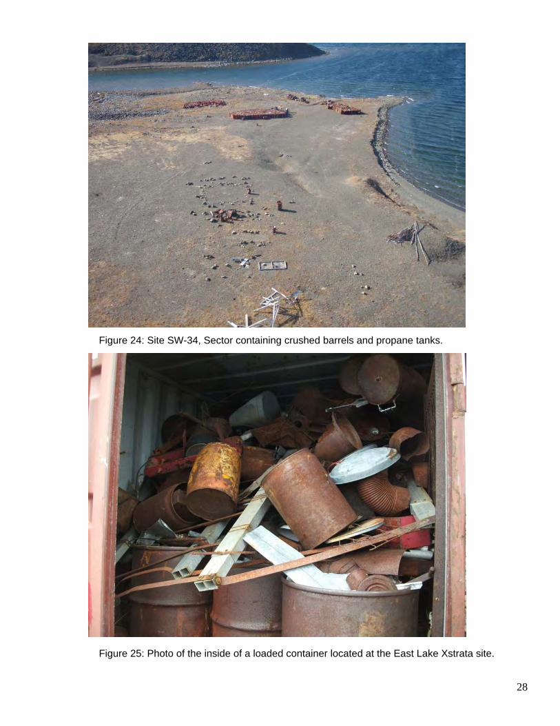
A team returned to the site in the winter of 2011 to remove some of the remaining items by snowmobile (Figure 23). This site will be considered as complete once this work is complete.
Figure 23: Worker removing snow to access material left on site PJ-10.
3.2 Ungava Trough – Hudson Bay
3.2.1. Salluit Sector SW-34 The abandoned mineral exploration site SW-34 (61º 34,90’ N, 74º 28,12’ W) is located next to Lake Esker, 90 km southeast of Salluit. The site comprises two sectors. The 2001-2002 inventory ranked this site second in importance for rehabilitation work. The site is spread across the properties of two mining companies: Xstrata Nickel operates north and east of Lake Esker and Goldbrook to the south and west. Most of the debris is located on the Goldbrook property. The 2001–2002 inventory identified a total of roughly 1500 barrels, chiefly on the Goldbrook property. In addition to barrels, the site contains not less than 40 propane tanks, batteries and used oil filters, equipment, etc. Figure 24 shows the site during a second inspection done in September 2009. During the winter of 2009, Xstrata delivered 2 empty containers to their East Lake camp, approximately 10 miles from the site. In August 2010, the clean-up work consisted of transporting the remaining 300 crushed drums by helicopter to the nearby containers where they were stored inside. Approximately 70 propane, oxygen and acetylene tanks were also transported and stored inside the containers. Some of the scrap metal waste was also transported to the containers (Figure 25). Approximately 20,000 pounds of metal was removed from the site. The two containers will be removed from the area by Xstrata during the winter of 2010. Nearly 500 uncrushed drums and several piles of scrap metal remain on site (Figure 26).
28
Figure 24: Site SW-34, Sector containing crushed barrels and propane tanks.
Figure 25: Photo of the inside of a loaded container located at the East Lake Xstrata site.
29
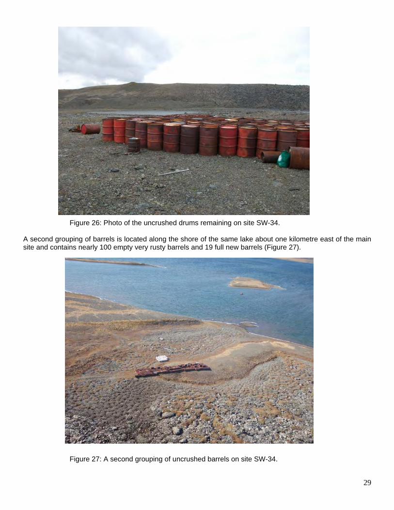
Figure 26: Photo of the uncrushed drums remaining on site SW-34.
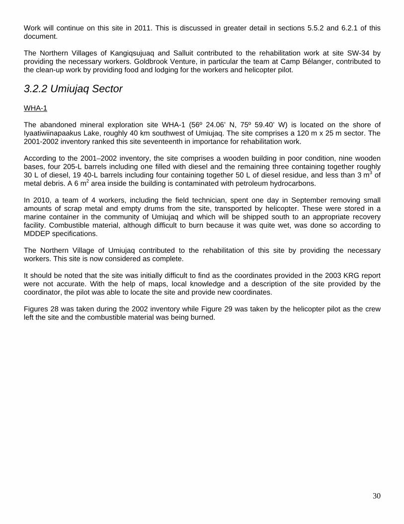
A second grouping of barrels is located along the shore of the same lake about one kilometre east of the main site and contains nearly 100 empty very rusty barrels and 19 full new barrels (Figure 27).
Figure 27: A second grouping of uncrushed barrels on site SW-34.
30
Work will continue on this site in 2011. This is discussed in greater detail in sections 5.5.2 and 6.2.1 of this document. The Northern Villages of Kangiqsujuaq and Salluit contributed to the rehabilitation work at site SW-34 by providing the necessary workers. Goldbrook Venture, in particular the team at Camp Bélanger, contributed to the clean-up work by providing food and lodging for the workers and helicopter pilot.
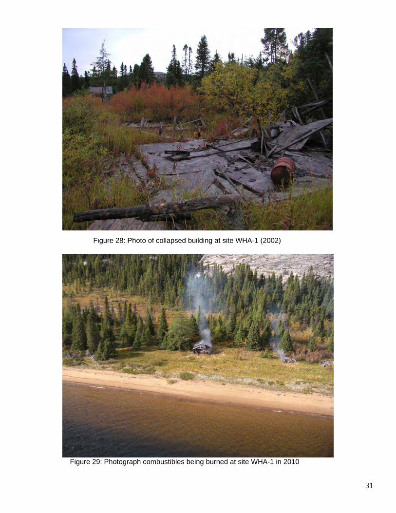
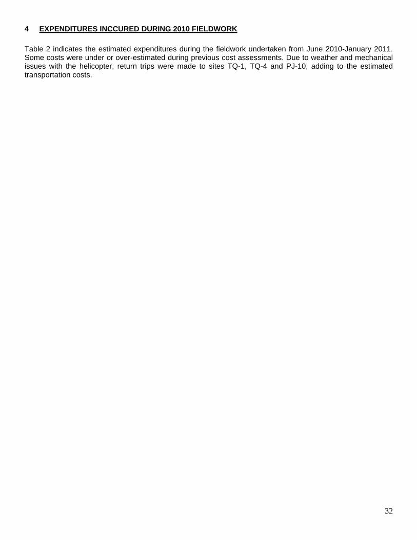
3.2.2 Umiujaq Sector WHA-1 The abandoned mineral exploration site WHA-1 (56º 24.06’ N, 75º 59.40’ W) is located on the shore of Iyaatiwiinapaakus Lake, roughly 40 km southwest of Umiujaq. The site comprises a 120 m x 25 m sector. The 2001-2002 inventory ranked this site seventeenth in importance for rehabilitation work. According to the 2001–2002 inventory, the site comprises a wooden building in poor condition, nine wooden bases, four 205-L barrels including one filled with diesel and the remaining three containing together roughly 30 L of diesel, 19 40-L barrels including four containing together 50 L of diesel residue, and less than 3 m3 of metal debris. A 6 m2 area inside the building is contaminated with petroleum hydrocarbons. In 2010, a team of 4 workers, including the field technician, spent one day in September removing small amounts of scrap metal and empty drums from the site, transported by helicopter. These were stored in a marine container in the community of Umiujaq and which will be shipped south to an appropriate recovery facility. Combustible material, although difficult to burn because it was quite wet, was done so according to MDDEP specifications. The Northern Village of Umiujaq contributed to the rehabilitation of this site by providing the necessary workers. This site is now considered as complete. It should be noted that the site was initially difficult to find as the coordinates provided in the 2003 KRG report were not accurate. With the help of maps, local knowledge and a description of the site provided by the coordinator, the pilot was able to locate the site and provide new coordinates. Figures 28 was taken during the 2002 inventory while Figure 29 was taken by the helicopter pilot as the crew left the site and the combustible material was being burned.
31
Figure 28: Photo of collapsed building at site WHA-1 (2002)
Figure 29: Photograph combustibles being burned at site WHA-1 in 2010
32
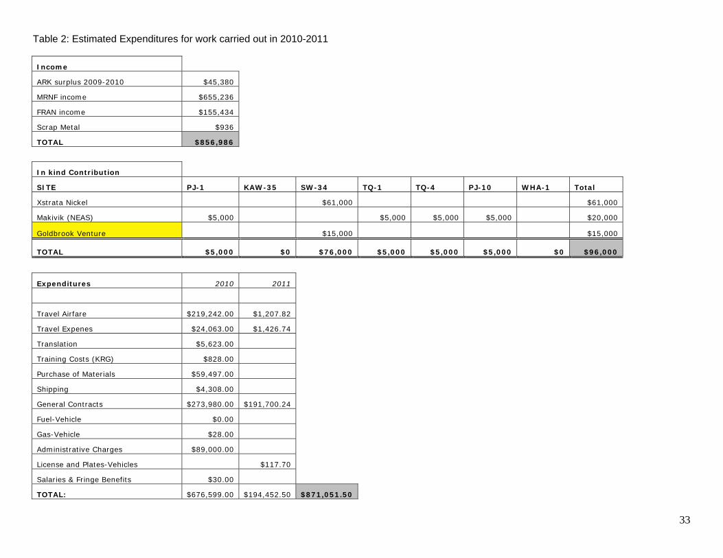
4 EXPENDITURES INCCURED DURING 2010 FIELDWORK
Table 2 indicates the estimated expenditures during the fieldwork undertaken from June 2010-January 2011. Some costs were under or over-estimated during previous cost assessments. Due to weather and mechanical issues with the helicopter, return trips were made to sites TQ-1, TQ-4 and PJ-10, adding to the estimated transportation costs.
33
Table 2: Estimated Expenditures for work carried out in 2010-2011
Income
ARK surplus 2009-2010 $45,380
MRNF income $655,236
FRAN income $155,434
Scrap Metal $936
TOTAL $856,986
In kind Contribution
SITE PJ-1 KAW-35 SW-34 TQ-1 TQ-4 PJ-10 WHA-1 Total
Xstrata Nickel $61,000 $61,000
Makivik (NEAS) $5,000 $5,000 $5,000 $5,000 $20,000
Goldbrook Venture $15,000 $15,000
TOTAL $5,000 $0 $76,000 $5,000 $5,000 $5,000 $0 $96,000
Expenditures 2010 2011
Travel Airfare $219,242.00 $1,207.82
Travel Expenes $24,063.00 $1,426.74
Translation $5,623.00
Training Costs (KRG) $828.00
Purchase of Materials $59,497.00
Shipping $4,308.00
General Contracts $273,980.00 $191,700.24
Fuel-Vehicle $0.00
Gas-Vehicle $28.00
Administrative Charges $89,000.00
License and Plates-Vehicles $117.70
Salaries & Fringe Benefits $30.00
TOTAL: $676,599.00 $194,452.50 $871,051.50
34
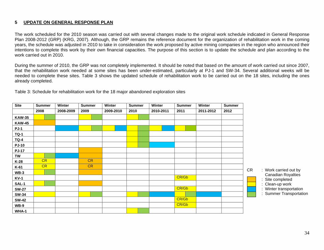
5 UPDATE ON GENERAL RESPONSE PLAN
The work scheduled for the 2010 season was carried out with several changes made to the original work schedule indicated in General Response Plan 2008-2012 (GRP) (KRG, 2007). Although, the GRP remains the reference document for the organization of rehabilitation work in the coming years, the schedule was adjusted in 2010 to take in consideration the work proposed by active mining companies in the region who announced their intentions to complete this work by their own financial capacities. The purpose of this section is to update the schedule and plan according to the work carried out in 2010. During the summer of 2010, the GRP was not completely implemented. It should be noted that based on the amount of work carried out since 2007, that the rehabilitation work needed at some sites has been under-estimated, particularly at PJ-1 and SW-34. Several additional weeks will be needed to complete these sites. Table 3 shows the updated schedule of rehabilitation work to be carried out on the 18 sites, including the ones already completed. Table 3: Schedule for rehabilitation work for the 18 major abandoned exploration sites
CR : Work carried out by
Canadian Royalties : Site completed : Clean-up work : Winter transportation
: Summer Transportation
Site Summer Winter Summer Winter Summer Winter Summer Winter Summer
2008 2008-2009 2009 2009-2010 2010 2010-2011 2011 2011-2012 2012
KAW-35
KAW-45
PJ-1
TQ-1
TQ-4
PJ-10
PJ-17
TW
K-28 CR CR
K-61 CR CR
WB-3
KV-1 CR/Gb
SAL-1
SW-27 CR/Gb
SW-34
SW-42 CR/Gb
WB-9 CR/Gb
WHA-1
35
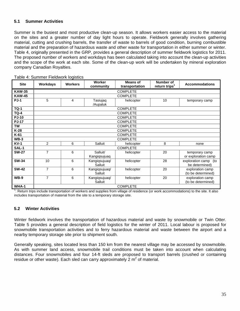
5.1 Summer Activities
Summer is the busiest and most productive clean-up season. It allows workers easier access to the material on the sites and a greater number of day light hours to operate. Fieldwork generally involves gathering material, cutting and crushing barrels, the transfer of waste to barrels of good condition, burning combustible material and the preparation of hazardous waste and other waste for transportation in either summer or winter. Table 4, originally presented in the GRP, provides a general description of summer fieldwork logistics for 2011. The proposed number of workers and workdays has been calculated taking into account the clean-up activities and the scope of the work at each site. Some of the clean-up work will be undertaken by mineral exploration company Canadian Royalties. Table 4: Summer Fieldwork logistics
Site Workdays Workers Worker community
Means of transportation
Number of return trips1 Accommodations
KAW-35 COMPLETE KAW-45 COMPLETE PJ-1 5 4 Tasiujaq
/Aupaluk helicopter 10 temporary camp
TQ-1 COMPLETE TQ-4 COMPLETE PJ-10 COMPLETE PJ-17 COMPLETE TW COMPLETE K-28 COMPLETE K-61 COMPLETE WB-3 COMPLETE KV-1 2 6 Salluit helicopter 8 none SAL-1 COMPLETE SW-27 7 6 Salluit/
Kangiqsujuaq helicopter 20 temporary camp
or exploration camp SW-34 10 6 Kangiqsujuaq/
Salluit helicopter 28 exploration camp (to
be determined) SW-42 7 6 Kangiqsujuaq/
Salluit helicopter 20 exploration camp
(to be determined) WB-9 7 6 Kangiqsujuaq/
Salluit helicopter 20 exploration camp
(to be determined) WHA-1 COMPLETE 1: Return trips include transportation of workers and supplies from village of residence (or work accommodations) to the site. It also includes transportation of material from the site to a temporary storage site.
5.2 Winter Activities
Winter fieldwork involves the transportation of hazardous material and waste by snowmobile or Twin Otter. Table 5 provides a general description of field logistics for the winter of 2011. Local labour is proposed for snowmobile transportation activities and to ferry hazardous material and waste between the airport and a nearby temporary storage site prior to shipment south. Generally speaking, sites located less than 150 km from the nearest village may be accessed by snowmobile. As with summer land access, snowmobile trail conditions must be taken into account when calculating distances. Four snowmobiles and four 14-ft sleds are proposed to transport barrels (crushed or containing residue or other waste). Each sled can carry approximately 2 m2 of material.

36
Table 5: Winter fieldwork logistics
Site
Workdays (number of return trips)
Workers
Worker community
Snow-mobile Twin Otter
Other Community Other
KAW-35 COMPLETE KAW-45 COMPLETE
PJ-1 TQ-1 COMPLETE TQ-4 COMPLETE PJ-10 PJ-17 COMPLETE
TW COMPLETE K-28 COMPLETE K-61 COMPLETE WB-3 COMPLETE KV-1
SAL-1 COMPLETE SW-27 SW-34 1 (1) Xstrata SW-42 WB-9
WHA-1 COMPLETE
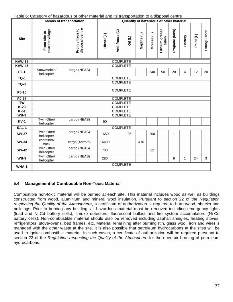
5.3 Transportation and Storage of Hazardous Waste
Table 6 shows the means of transportation proposed for each site as well as the material to be removed from each. All recoverable hazardous material (petroleum hydrocarbon and other residue) will be shipped to Veolia Environmental Services or another appropriate recovery facility in the south of the province. The transfer of residue to undamaged containers and labelling will be carried out during summer fieldwork.
37
Table 6: Category of hazardous or other material and its transportation to a disposal centre
Site
Means of transportation Quantity of hazardous or other material
Fro
m s
ite
to
nea
rest
vill
age
F
rom
vill
age
to
dis
po
sal c
entr
e
Die
sel (
L)
An
ti-f
reez
e (L
)
Oil
(L
)
Nap
hta
(L
)
Gre
ase
(L)
Lit
hiu
m g
reas
e tu
bes
Pro
pan
e (t
ank)
Bat
tery
Pai
nt
(L)
Ext
ing
uis
her
KAW-35 COMPLETE KAW-45 COMPLETE
PJ-1 Snowmobile/
helicopter cargo (NEAS)
240 50 20 4 12 20
TQ-1 COMPLETE
TQ-4 COMPLETE
PJ-10 COMPLETE
PJ-17 COMPLETE TW COMPLETE
K-28 COMPLETE K-61 COMPLETE WB-3 COMPLETE
KV-1 Twin Otter/ helicopter
cargo (NEAS) 50
SAL-1 COMPLETE
SW-27 Twin Otter/ helicopter
cargo (NEAS) 1650 26 260 1
SW-34 container/
truck cargo (Xstrata) 16400 410 1
SW-42 Twin Otter/ helicopter
cargo (NEAS) 700 12
WB-9 Twin Otter/ helicopter
cargo (NEAS) 280 9 1 24 3
WHA-1 COMPLETE
5.4 Management of Combustible Non-Toxic Material
Combustible non-toxic material will be burned at each site. This material includes wood as well as buildings constructed from wood, aluminium and mineral wool insulation. Pursuant to section 22 of the Regulation respecting the Quality of the Atmosphere, a certificate of authorization is required to burn wood, shacks and buildings. Prior to burning any building, all hazardous material must be removed including emergency lights (lead and Ni-Cd battery cells), smoke detectors, fluorescent ballast and fire system accumulators (Ni-Cd battery cells). Non-combustible material should also be removed including asphalt shingles, heating stoves, refrigerators, stove-ovens, bed frames, etc. Material remaining after burning (tin, glass wool, iron and wire) is managed with the other waste at the site. It is also possible that petroleum hydrocarbons at the sites will be used to ignite combustible material. In such cases, a certificate of authorization will be required pursuant to section 23 of the Regulation respecting the Quality of the Atmosphere for the open-air burning of petroleum hydrocarbons.
38
5.5 Management of Non-Combustible Non-Toxic Material
At most of the sites, non-combustible non-toxic material represents the greatest quantity of debris (empty barrels, equipment parts, domestic appliances, wire meshing, etc.) and is the least likely to be harmful to the environment or to jeopardize the health of animals and humans. Notwithstanding, such material adversely affects the appearance of the landscape. For this reason, wherever possible all waste will be removed from the sites. At the sites KAW-35 and PJ-1, the removal of material and heavy equipment will require more planning and ultimately be costlier.
5.6 Petroleum-Hydrocarbon Soil Contamination and Acid Mine Drainage
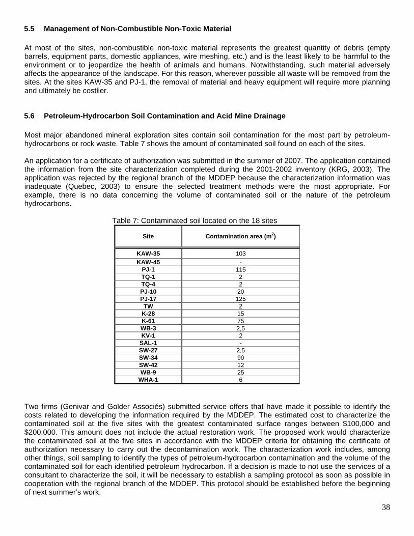
Most major abandoned mineral exploration sites contain soil contamination for the most part by petroleum-hydrocarbons or rock waste. Table 7 shows the amount of contaminated soil found on each of the sites. An application for a certificate of authorization was submitted in the summer of 2007. The application contained the information from the site characterization completed during the 2001-2002 inventory (KRG, 2003). The application was rejected by the regional branch of the MDDEP because the characterization information was inadequate (Quebec, 2003) to ensure the selected treatment methods were the most appropriate. For example, there is no data concerning the volume of contaminated soil or the nature of the petroleum hydrocarbons.
Table 7: Contaminated soil located on the 18 sites
Site Contamination area (m2)
KAW-35 103
KAW-45 - PJ-1 115 TQ-1 2 TQ-4 2 PJ-10 20 PJ-17 125 TW 2
K-28 15 K-61 75 WB-3 2,5 KV-1 2
SAL-1 - SW-27 2,5 SW-34 90 SW-42 12 WB-9 25
WHA-1 6
Two firms (Genivar and Golder Associés) submitted service offers that have made it possible to identify the costs related to developing the information required by the MDDEP. The estimated cost to characterize the contaminated soil at the five sites with the greatest contaminated surface ranges between $100,000 and $200,000. This amount does not include the actual restoration work. The proposed work would characterize the contaminated soil at the five sites in accordance with the MDDEP criteria for obtaining the certificate of authorization necessary to carry out the decontamination work. The characterization work includes, among other things, soil sampling to identify the types of petroleum-hydrocarbon contamination and the volume of the contaminated soil for each identified petroleum hydrocarbon. If a decision is made to not use the services of a consultant to characterize the soil, it will be necessary to establish a sampling protocol as soon as possible in cooperation with the regional branch of the MDDEP. This protocol should be established before the beginning of next summer’s work.
39
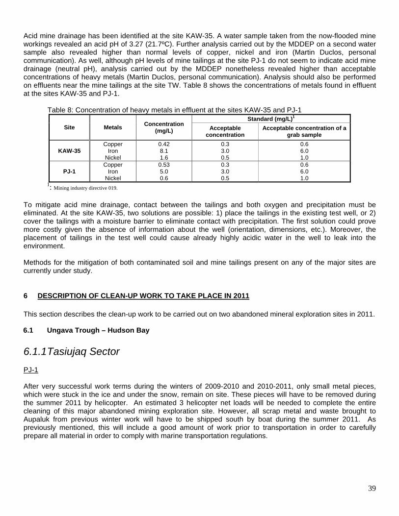
Acid mine drainage has been identified at the site KAW-35. A water sample taken from the now-flooded mine workings revealed an acid pH of 3.27 (21.7ºC). Further analysis carried out by the MDDEP on a second water sample also revealed higher than normal levels of copper, nickel and iron (Martin Duclos, personal communication). As well, although pH levels of mine tailings at the site PJ-1 do not seem to indicate acid mine drainage (neutral pH), analysis carried out by the MDDEP nonetheless revealed higher than acceptable concentrations of heavy metals (Martin Duclos, personal communication). Analysis should also be performed on effluents near the mine tailings at the site TW. Table 8 shows the concentrations of metals found in effluent at the sites KAW-35 and PJ-1. Table 8: Concentration of heavy metals in effluent at the sites KAW-35 and PJ-1
Site Metals Concentration
(mg/L)
Standard (mg/L)1
Acceptable concentration
Acceptable concentration of a grab sample
KAW-35 Copper
Iron Nickel
0.42 8.1 1.6
0.3 3.0 0.5
0.6 6.0 1.0
PJ-1 Copper
Iron Nickel
0.53 5.0 0.6
0.3 3.0 0.5
0.6 6.0 1.0
1: Mining industry directive 019. To mitigate acid mine drainage, contact between the tailings and both oxygen and precipitation must be eliminated. At the site KAW-35, two solutions are possible: 1) place the tailings in the existing test well, or 2) cover the tailings with a moisture barrier to eliminate contact with precipitation. The first solution could prove more costly given the absence of information about the well (orientation, dimensions, etc.). Moreover, the placement of tailings in the test well could cause already highly acidic water in the well to leak into the environment. Methods for the mitigation of both contaminated soil and mine tailings present on any of the major sites are currently under study.
6 DESCRIPTION OF CLEAN-UP WORK TO TAKE PLACE IN 2011
This section describes the clean-up work to be carried out on two abandoned mineral exploration sites in 2011.
6.1 Ungava Trough – Hudson Bay
6.1.1 Tasiujaq Sector PJ-1 After very successful work terms during the winters of 2009-2010 and 2010-2011, only small metal pieces, which were stuck in the ice and under the snow, remain on site. These pieces will have to be removed during the summer 2011 by helicopter. An estimated 3 helicopter net loads will be needed to complete the entire cleaning of this major abandoned mining exploration site. However, all scrap metal and waste brought to Aupaluk from previous winter work will have to be shipped south by boat during the summer 2011. As previously mentioned, this will include a good amount of work prior to transportation in order to carefully prepare all material in order to comply with marine transportation regulations.
40
6.1.2 Salluit Sector SW-34 A drum crusher was purchased during the summer of 2010 and transported to Deception Bay and then to their main exploitation site by Xstrata. This drum crusher was delivered in 2 pieces to allow for it to be transported to the site by helicopter during the summer 2011 work term. It will then be assembled on site and used to crush the remaining drums after which metal debris as well as the crushed and non-crushed (containing residue) barrels can be prepared for removal from the site by helicopter. It is recommended that during the winter of 2011, the Xstrata Exploration staff transport two or three more containers to their East Lake camp located relatively close to site SW-34. These containers can then be loaded with the debris as was done during the summer of 2010 and transported during the winter months. Again, collaboration with both Goldbrook Venture and Xstrata Nickel could prove helpful to the rehabilitation efforts.
6.2 Inspections
6.2.1 Major Sites
It is recommended that once all the 18 major sites are considered completed that a final inspection be done at each site. This will allow KRG to properly assess whether any remaining actions are needed as well as an opportunity to take comparison photos for the final report. This can be done at the end of the 2011 work season, by helicopter. 6.2.2 Intermediate Sites During the Follow-up Committee meeting held on August 23, 2010, it was decided that an initial inspection of the intermediate sites noted in the 2001-2002 inventory should be done. This will allow for an estimation of future clean-up work that can be undertaken in the region. This inspection can be done during the summer of 2011, by helicopter.
6.3 Community Tour
A tour of the communities directly involved in the clean-up work should be scheduled for the end of the 2011 season. These communities include Kuujjuaq, Tasiujaq, Aupaluk, Kangirsuk, Kangiqsujuaq, Salluit, Umiujaq and Kawawachikamach. A power-point presentation could be prepared outlining the work undertaken on each of the 18 major sites as well as a summary of any upcoming work. A further presentation could be made during a KRG regional council meeting, which is usually attended by a representative from each of the 14 Inuit communities. Furthermore, a special correspondence should be sent to each of the project contributors and those organizations that assisted in the clean-up efforts.

41
42
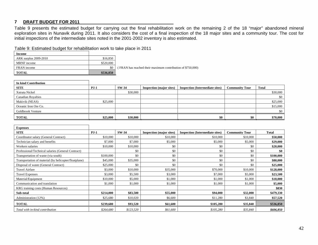
7 DRAFT BUDGET FOR 2011
Table 9 presents the estimated budget for carrying out the final rehabilitation work on the remaining 2 of the 18 “major” abandoned mineral exploration sites in Nunavik during 2011. It also considers the cost of a final inspection of the 18 major sites and a community tour. The cost for initial inspections of the intermediate sites noted in the 2001-2002 inventory is also estimated. Table 9: Estimated budget for rehabilitation work to take place in 2011
Income
ARK surplus 2009-2010 $16,850
MRNF income $520,000
FRAN income $0 ( FRAN has reached their maximum contribution of $750,000)
TOTAL $536,850
In kind Contribution SITE PJ-1 SW-34 Inspection (major sites) Inspection (Intermediate sites) Community Tour Total Xstrata Nickel $30,000 $30,000
Canadian Royalties $0
Makivik (NEAS) $25,000 $25,000
Oceanic Iron Ore Co. $15,000
Goldbrook Venture $0
TOTAL $25,000 $30,000 $0 $0 $70,000
Expenses SITE PJ-1 SW-34 Inspection (major sites) Inspection (Intermediate sites) Community Tour Total Coordinator salary (General Contract) $10,000 $10,000 $10,000 $10,000 $10,000 $50,000 Technician salary and benefits $7,000 $7,000 $5,000 $5,000 $5,000 $29,000 Workers salaries $10,000 $10,000 $0 $0 $0 $20,000 Professional/Technical salaries (General Contract) $0 $0 $0 $0 $0 Transportation of waste (via south) $100,000 $0 $0 $0 $0 $100,000 Transportation of material (by helicopter/floatplane) $45,000 $35,000 $0 $0 $0 $80,000 Disposal of waste (General Contract) $25,000 $0 $0 $0 $0 $25,000 Travel Airfare $3,000 $10,000 $35,000 $70,000 $10,000 $128,000 Travel Expenses $3,000 $5,500 $3,000 $7,000 $5,000 $23,500 Material/Equipment $10,000 $5,000 $1,000 $1,000 $1,000 $18,000 Communication and translation $1,000 $1,000 $1,000 $1,000 $1,000 $5,000 KRG training costs (Human Resources) $830 Sub-total $214,000 $83,500 $55,000 $94,000 $32,000 $479,330 Administration (12%) $25,680 $10,020 $6,600 $11,280 $3,840 $57,520
TOTAL $239,680 $93,520 $61,600 $105,280 $35,840 $536,850
Total with in-kind contribution $264,680 $123,520 $61,600 $105,280 $35,840 $606,850
43
8 DESCRIPTION OF CLEAN-UP WORK TO BE CARRIED OUT BY MINING COMPANIES
The following section describes work to be carried out in 2011 by active mining companies in the region who announced their intentions to complete this work by their own financial capacities.
8.1 Ungava Trough – Hudson Bay
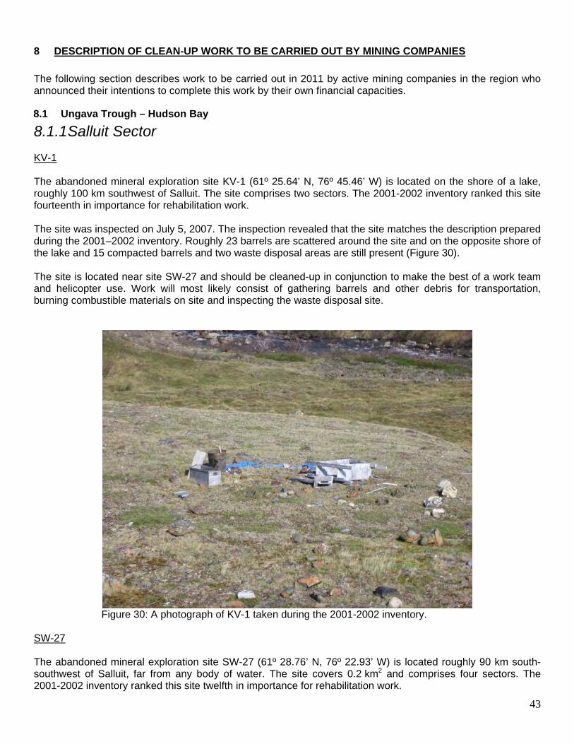
8.1.1 Salluit Sector KV-1 The abandoned mineral exploration site KV-1 (61º 25.64’ N, 76º 45.46’ W) is located on the shore of a lake, roughly 100 km southwest of Salluit. The site comprises two sectors. The 2001-2002 inventory ranked this site fourteenth in importance for rehabilitation work. The site was inspected on July 5, 2007. The inspection revealed that the site matches the description prepared during the 2001–2002 inventory. Roughly 23 barrels are scattered around the site and on the opposite shore of the lake and 15 compacted barrels and two waste disposal areas are still present (Figure 30). The site is located near site SW-27 and should be cleaned-up in conjunction to make the best of a work team and helicopter use. Work will most likely consist of gathering barrels and other debris for transportation, burning combustible materials on site and inspecting the waste disposal site.
Figure 30: A photograph of KV-1 taken during the 2001-2002 inventory.
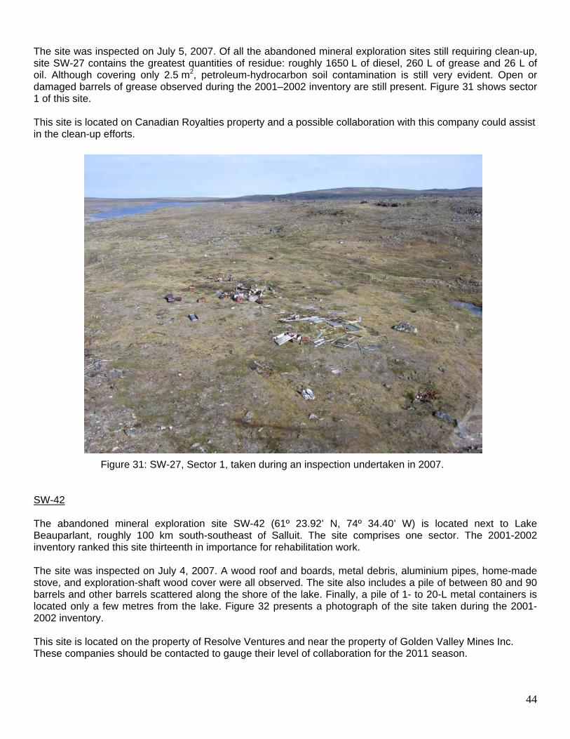
SW-27 The abandoned mineral exploration site SW-27 (61º 28.76’ N, 76º 22.93’ W) is located roughly 90 km south-southwest of Salluit, far from any body of water. The site covers 0.2 km2 and comprises four sectors. The 2001-2002 inventory ranked this site twelfth in importance for rehabilitation work.
44
The site was inspected on July 5, 2007. Of all the abandoned mineral exploration sites still requiring clean-up, site SW-27 contains the greatest quantities of residue: roughly 1650 L of diesel, 260 L of grease and 26 L of oil. Although covering only 2.5 m2, petroleum-hydrocarbon soil contamination is still very evident. Open or damaged barrels of grease observed during the 2001–2002 inventory are still present. Figure 31 shows sector 1 of this site. This site is located on Canadian Royalties property and a possible collaboration with this company could assist in the clean-up efforts.
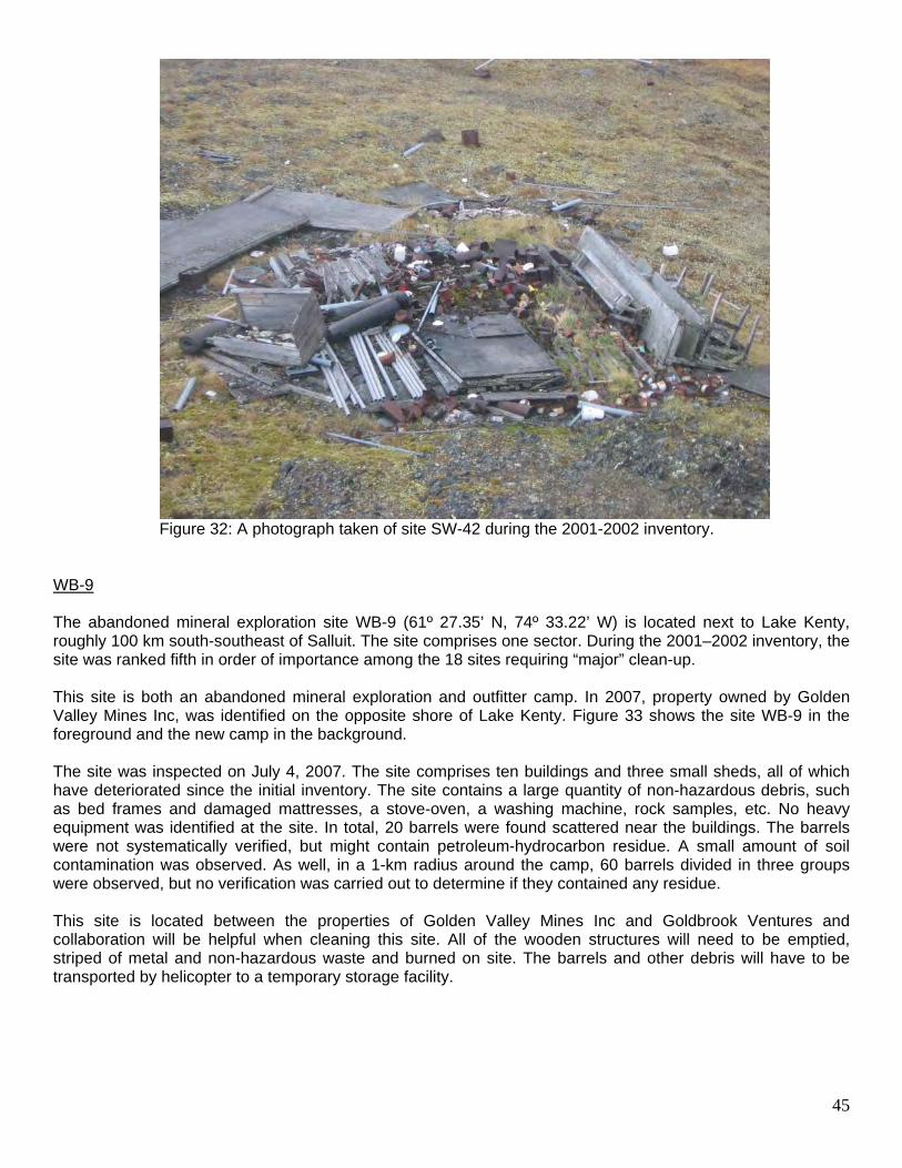
Figure 31: SW-27, Sector 1, taken during an inspection undertaken in 2007. SW-42 The abandoned mineral exploration site SW-42 (61º 23.92’ N, 74º 34.40’ W) is located next to Lake Beauparlant, roughly 100 km south-southeast of Salluit. The site comprises one sector. The 2001-2002 inventory ranked this site thirteenth in importance for rehabilitation work. The site was inspected on July 4, 2007. A wood roof and boards, metal debris, aluminium pipes, home-made stove, and exploration-shaft wood cover were all observed. The site also includes a pile of between 80 and 90 barrels and other barrels scattered along the shore of the lake. Finally, a pile of 1- to 20-L metal containers is located only a few metres from the lake. Figure 32 presents a photograph of the site taken during the 2001-2002 inventory. This site is located on the property of Resolve Ventures and near the property of Golden Valley Mines Inc. These companies should be contacted to gauge their level of collaboration for the 2011 season.
45
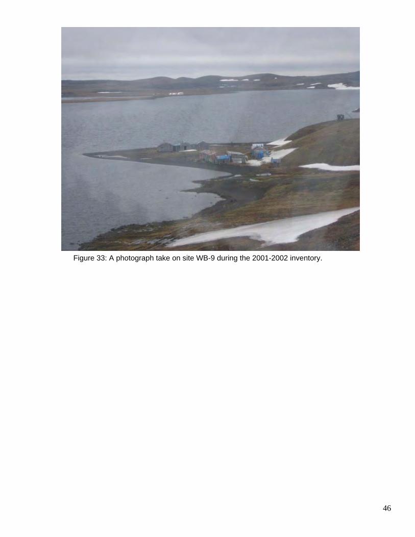
Figure 32: A photograph taken of site SW-42 during the 2001-2002 inventory. WB-9 The abandoned mineral exploration site WB-9 (61º 27.35’ N, 74º 33.22’ W) is located next to Lake Kenty, roughly 100 km south-southeast of Salluit. The site comprises one sector. During the 2001–2002 inventory, the site was ranked fifth in order of importance among the 18 sites requiring “major” clean-up. This site is both an abandoned mineral exploration and outfitter camp. In 2007, property owned by Golden Valley Mines Inc, was identified on the opposite shore of Lake Kenty. Figure 33 shows the site WB-9 in the foreground and the new camp in the background. The site was inspected on July 4, 2007. The site comprises ten buildings and three small sheds, all of which have deteriorated since the initial inventory. The site contains a large quantity of non-hazardous debris, such as bed frames and damaged mattresses, a stove-oven, a washing machine, rock samples, etc. No heavy equipment was identified at the site. In total, 20 barrels were found scattered near the buildings. The barrels were not systematically verified, but might contain petroleum-hydrocarbon residue. A small amount of soil contamination was observed. As well, in a 1-km radius around the camp, 60 barrels divided in three groups were observed, but no verification was carried out to determine if they contained any residue. This site is located between the properties of Golden Valley Mines Inc and Goldbrook Ventures and collaboration will be helpful when cleaning this site. All of the wooden structures will need to be emptied, striped of metal and non-hazardous waste and burned on site. The barrels and other debris will have to be transported by helicopter to a temporary storage facility.
46
Figure 33: A photograph take on site WB-9 during the 2001-2002 inventory.
47
9 HUMAN RESOURCES
Except for the environmental consultants required for the treatment of contaminated soil and acid mine drainage, human resources for the project fall into two categories: 1) KRG employees, which is to say the project co-ordinator and environmental or field technicians, and 2) local workers. The project co-ordinator works full-time on the project while the environmental or field technicians only work full-time during the summer season. Experience acquired in the previous work terms suggests that it is absolutely necessary to have one and in some case two technicians on site to complete the clean-up according to the schedule and to allow for more coherent logistical planning by the coordinator. Local workers are hired to work on the project from the communities located closest to each site. This not only creates jobs, but it also contributes to increasing local know-how regarding contaminated soil restoration and environmental project management. The Northern Villages are central to providing local workers for the rehabilitation work, including the payment of the workers’ wages. The amounts paid for these workers are subsequently invoiced to the KRG which reimburses all related costs. This cooperation is extremely effective and permits the hiring of individuals who are recognized in their communities. This kind of experience is also highly sought-after by mineral exploration companies for the clean-up of their sites and could therefore lead to future work. Summer clean-up work at each site requires an environmental or field technician and between three and six workers. Winter fieldwork, including snowmobile transportation and Twin Otter unloading generally requires four workers and a supervisor. In 2010, an Inuit field technician was hired on a temporary full-time contract by the KRG. Charlie Akpahatak, from Aupaluk, provided leadership and crucial local knowledge regarding local landscape and transportation logistics during the fieldwork on each of the 7 sites. He also provided a vital link between the coordinator and the local workers hired from each community as well as the activities that transpired on each site. Worker safety is also an important issue for those involved in rehabilitating the major abandoned mineral exploration sites in Nunavik. All of the sites to be rehabilitated are in isolated locations that cannot easily be reached from nearby villages. Workers are most often transported by helicopter or floatplane. Since the transporter does not remain at the site, emergency planning is important. It is essential that each work team has an emergency plan and adequate communication systems to contact help, if necessary. The combined use of satellite phones and “spot” technology is highly recommended. Furthermore, an HF radio that allows for transmission between pilot and field team is useful as it permits an increased communication with pilots and other workers and ensures a greater safety when transporting equipment and during landing and take-off.
10 COMMUNICATIONS
A communication was prepared by KRG (Appendix 3) to provide an update of the rehabilitation wok carried out on each site in 2010 and a list of those sites that will be completed in the future. The press release was made public on the KRG website and sent to the organizations and communities directly involved in the project. In the winter of 2012, visits to each of the communities that participated in the clean-up work will be organized in order to present the project, specifically the results of the rehabilitation work completed at each of the sites. A final report will be transmitted to the Inuit, Naskapi and Innu communities, and a follow-up meeting is planned with project partners.
48
11 REFERENCES
Barrett, M. and R. Lanari, 2003. Remedial Measures and Completion of the Assessment of Nunavik’s
Abandoned Mining Exploration Sites. Kativik Regional Government, Makivik Corporation, 27 p. Kativik Regional Government, 2003. Assessment and Prioritization of Abandoned Mining Exploration Sites in
Nunavik: Final Report on a Two-Year Project (2001–2002). Kativik Regional Government, Makivik Corporation, Kuujjuaq. 67 p. and appendices.
Kativik Regional Government, 2006. Assessment and Prioritization of Abandoned Mining Exploration Sites in
Nunavik: Progress Report for the Year 2005–2006 of the Project. Kativik Regional Government, Kuujjuaq. 24 p. and appendices.
Kativik Regional Government, 2007. Assessment and Prioritization of Abandoned Mining Exploration Sites in
Nunavik: Progress Report for the Year 2006–2007 of the Project. Kativik Regional Government, Kuujjuaq. 27 p. and appendices.
Kativik Regional Government, 2008. Summary Report on Rehabilitation Work at the 18 “Major”
Abandoned Mineral Exploration Sites in Nunavik Carried Out in the Summer of 2008 and Update on General Response Plan. Kativik Regional Government, Kuujjuaq. 49 p. and appendices.
Nancy Dea/Nathalie Girard Project Coordinators April, 2011
49
APPENDIX 1
MAPS OF THE 18 “MAJOR” EXPLORATION SITES
50
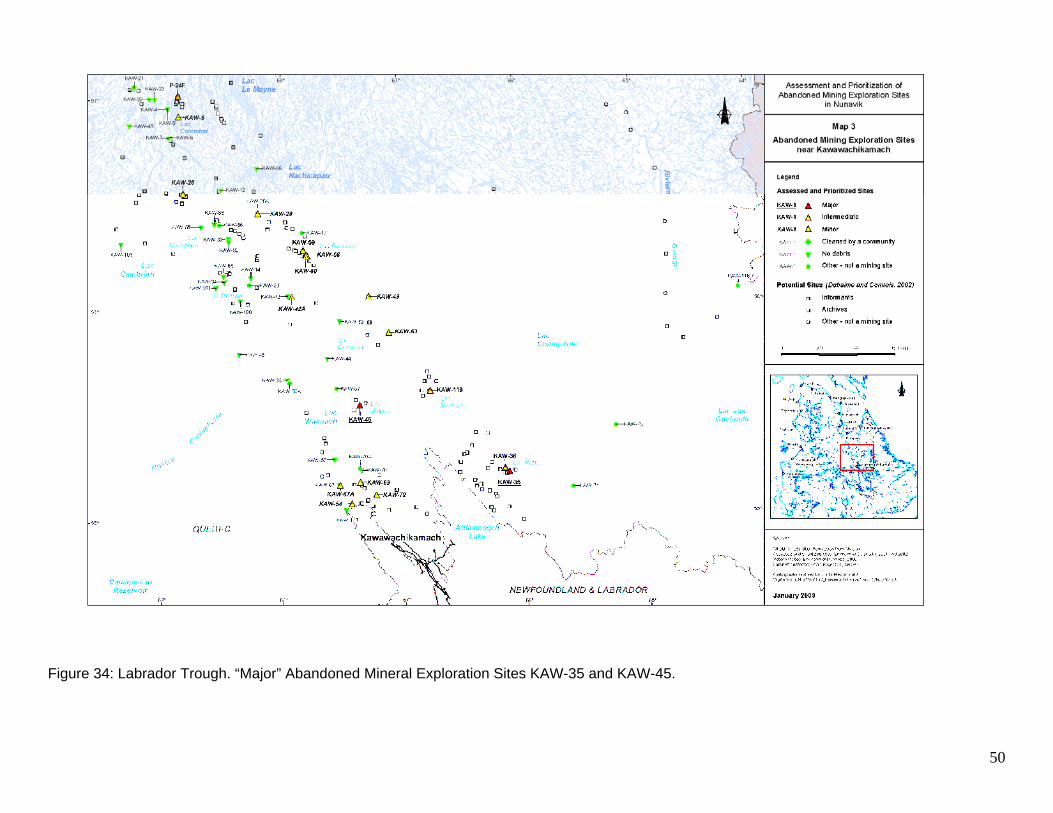
Figure 34: Labrador Trough. “Major” Abandoned Mineral Exploration Sites KAW-35 and KAW-45.
51
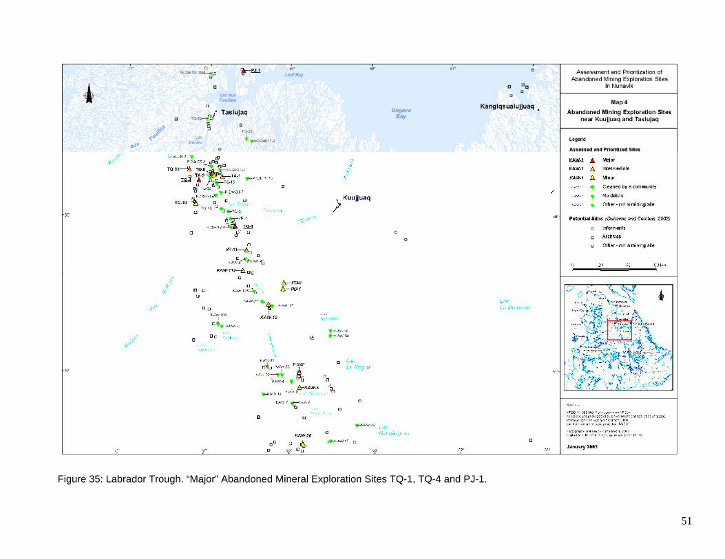
Figure 35: Labrador Trough. “Major” Abandoned Mineral Exploration Sites TQ-1, TQ-4 and PJ-1.
52
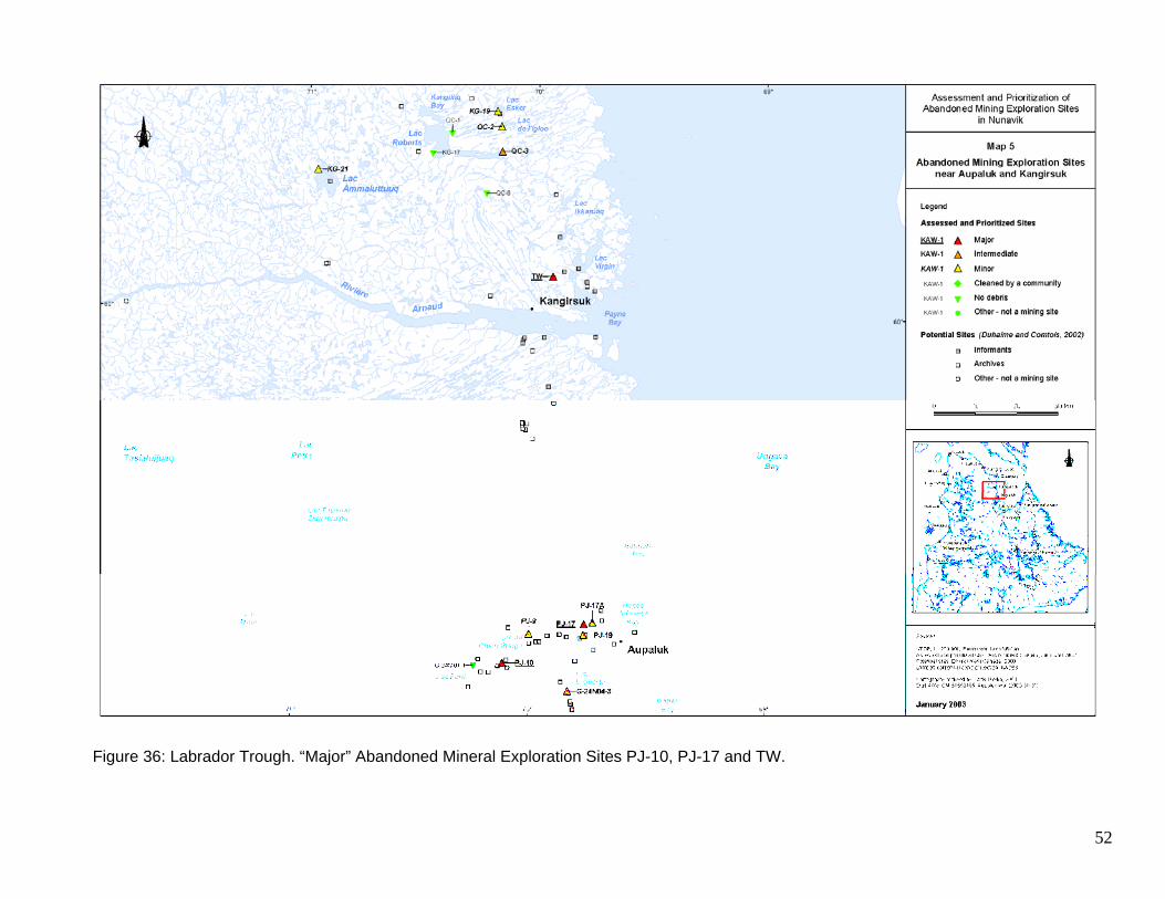
Figure 36: Labrador Trough. “Major” Abandoned Mineral Exploration Sites PJ-10, PJ-17 and TW.
53
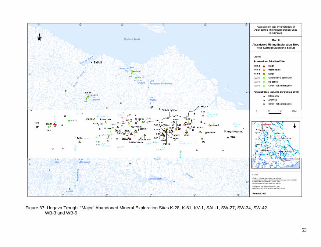
Figure 37: Ungava Trough. “Major” Abandoned Mineral Exploration Sites K-28, K-61, KV-1, SAL-1, SW-27, SW-34, SW-42
WB-3 and WB-9.
54
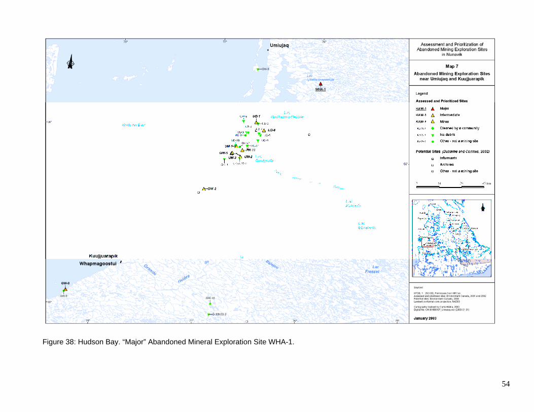
Figure 38: Hudson Bay. “Major” Abandoned Mineral Exploration Site WHA-1.
APPENDIX 2 REHABILITATION WORK CARRIED OUT BY CANADIAN ROYALTIES
Projet Nunavik Nickel
Nunavik Nickel Project
REPORT ON REMEDIATION WORK CARRIED OUT ON ABANDONED MINING
EXPLORATION SITES LOCATED ON CANADIAN ROYALTIES’ PROPERTY,
2010 Season
November 2010
TABLE OF CONTENTS
Page
1. Introduction 3 2. 2010 Remediation Work 4 2.1 Description of activities 4 2.2 Work Team 4 2.3 Residual Materials & Health and Safety 5 2.4 CRI Achievements since 2002 5 3. Conclusion 8
2010 Clean-up Program Remediation of abandoned mining exploration sites
LIST OF TABLES
Table 1 List of sites that were cleaned and rehabilitated by CRI – 2002-2010
LIST OF ANNEXES
Annex A Location Map of Abandoned Mining Exploration Sites Annex B Location of Clean-up sites - 2010 Annex C Photographs
introduction
In 2001 and 2002, the Kativik Regional Government (KRG) performed an inventory of abandoned mineral exploration sites on the Nunavik territory. During this process 193 potential sites were visited, of which 90 were identified as abandoned mineral exploration sites. There are still 300 potential sites that remain to be inventoried. These sites are a threat to the environment and to human health, and it was imperative that immediate action be initiated for the remediation of these sites. During the last 8 years, Canadian Royalties Inc. (CRI) has voluntarily proceeded to clean-up more than 50 abandoned mineral exploration sites in the course of its exploration activities and during the development of the Nunavik Nickel Project. During the remediation activities, thousands of barrels (mainly fuel barrels), various scrap materials as well as residual hazardous materials (RHM) were collected and transported to the Expo and Berbegamo exploration sites in use by Canadian Royalties. CRI is a founding member of the “Fonds Restor-Action Nunavik” (FRAN) that aims to rehabilitate old abandoned mining exploration sites in northern Quebec. During 2010 exploration season, CRI had completed the cleaning of its intervening territory. Actually, CRI had clean-up all the exploration rubbishes left on land where its 2010 exploration had occurred.
2010 remediation work
Description of activities
The clean-up activities carried out on abandoned sites were similar from site to site and were directly related to the exploration activities performed. Generally, the work revolved around the collection of: abandoned bags of calcium chloride, scrap metal, abandoned vehicles, batteries, empty fuel barrels, tires, contaminated soils, various containers (acid, paint, grease, oil, etc.). The activities were conducted in a rectangular territory covering 420 km2 and limited by the following UTM Zone 18 coordinates (see map as Appendix A):
562559 E 6832202 N 592733 E 6832202 N
562559 E 6817075 N 592733 E 6817075 N
A total of 56 sites were clean-up in that territory. The collected materials (barrels, pallets and
tires) were brought to Berbegamo camp. The barrels were cleaned, pressed and packed in
containers to be sent South by ship in September. The scrap metal will be disposed adequately
before the end of the year.
The coordinates of the 56 sites are presented as appendix B and some pictures in appendix C.
Most of the sites were not really exploration sites but isolated barrels left on the tundra. For this
reason, they were not listed on FRAN inventory; although now one can say that the 420 km2
territory surveyed during exploration activities is returned to a pre-exploration state.
Work Team
In 2010, the exploration/geological teams took care of the cleaning activities and to bring back the rubbish to Berbegamo. There, labourers emptied, cleaned and stacked the materials in containers in order to send it South. As for the previous years, inuit labourers are favoured for these jobs because they appreciate working outside.
Residual Materials & Health and Safety
Particular attention was paid to the recovery of residual materials as well as the health and safety of all the workers involved. Because some of the materials present a serious threat to the environment and to human health, several safety measures were adopted during handling:
Personal protective equipment was mandatory.
Work teams were careful to avoid any leakage or spill from the recovered materials;
Scrap metals with sharp edges were handled carefully (with PPE) in order to
prevent scratches and cuts;
Some of the debris was heavy. Work teams took special precautions and
used proper equipment to avoid injuries (2 men to handle debris, use of
straps, etc.);
Special attention was paid when opening barrels (odour, vapour release, etc.)
CRI Achievements since 2002
CRI has voluntarily undertaken clean-up and remediation operations on old abandoned mining exploration sites since 2002. To date more than 50 old abandoned sites have been rehabilitated or cleaned according to their type and category. See Table 1.
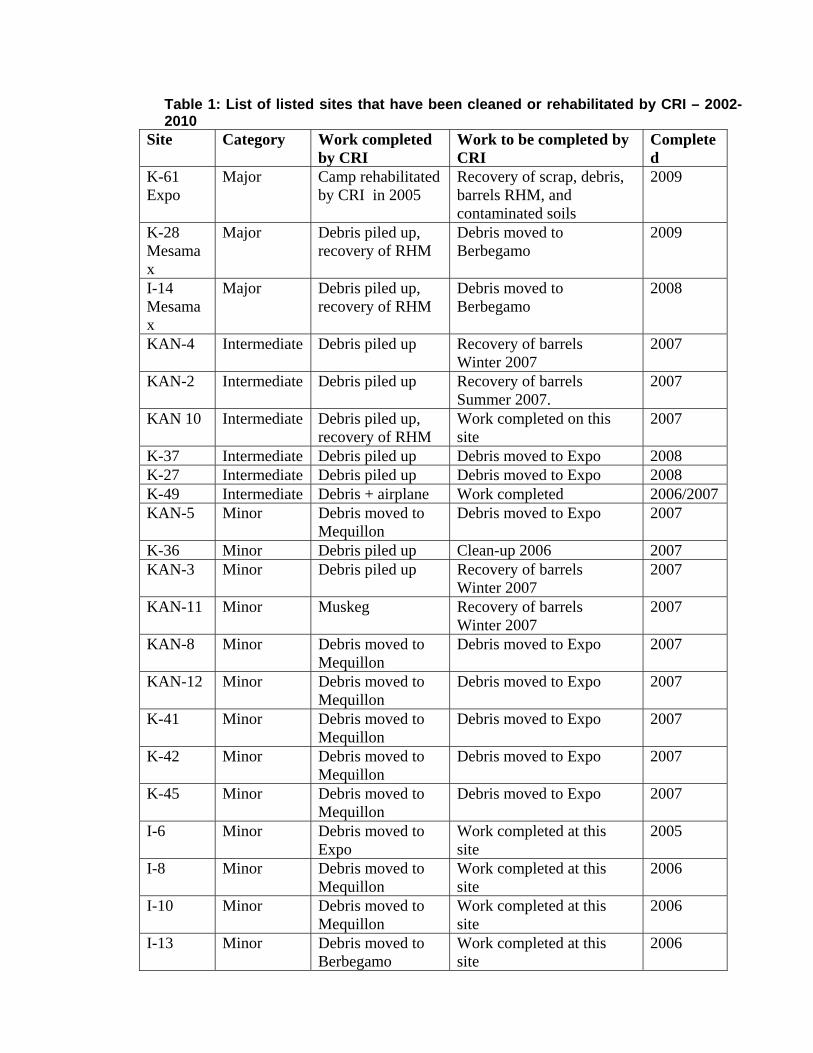
Table 1: List of listed sites that have been cleaned or rehabilitated by CRI – 2002-2010
Site Category Work completed by CRI
Work to be completed by CRI
Completed
K-61 Expo
Major Camp rehabilitated by CRI in 2005
Recovery of scrap, debris, barrels RHM, and contaminated soils
2009
K-28 Mesamax
Major Debris piled up, recovery of RHM
Debris moved to Berbegamo
2009
I-14 Mesamax
Major Debris piled up, recovery of RHM
Debris moved to Berbegamo
2008
KAN-4 Intermediate Debris piled up Recovery of barrels Winter 2007
2007
KAN-2 Intermediate Debris piled up Recovery of barrels Summer 2007.
2007
KAN 10 Intermediate Debris piled up, recovery of RHM
Work completed on this site
2007
K-37 Intermediate Debris piled up Debris moved to Expo 2008 K-27 Intermediate Debris piled up Debris moved to Expo 2008 K-49 Intermediate Debris + airplane Work completed 2006/2007 KAN-5 Minor Debris moved to
Mequillon Debris moved to Expo 2007
K-36 Minor Debris piled up Clean-up 2006 2007 KAN-3 Minor Debris piled up Recovery of barrels
Winter 2007 2007
KAN-11 Minor Muskeg Recovery of barrels Winter 2007
2007
KAN-8 Minor Debris moved to Mequillon
Debris moved to Expo 2007
KAN-12 Minor Debris moved to Mequillon
Debris moved to Expo 2007
K-41 Minor Debris moved to Mequillon
Debris moved to Expo 2007
K-42 Minor Debris moved to Mequillon
Debris moved to Expo 2007
K-45 Minor Debris moved to Mequillon
Debris moved to Expo 2007
I-6 Minor Debris moved to Expo
Work completed at this site
2005
I-8 Minor Debris moved to Mequillon
Work completed at this site
2006
I-10 Minor Debris moved to Mequillon
Work completed at this site
2006
I-13 Minor Debris moved to Berbegamo
Work completed at this site
2006
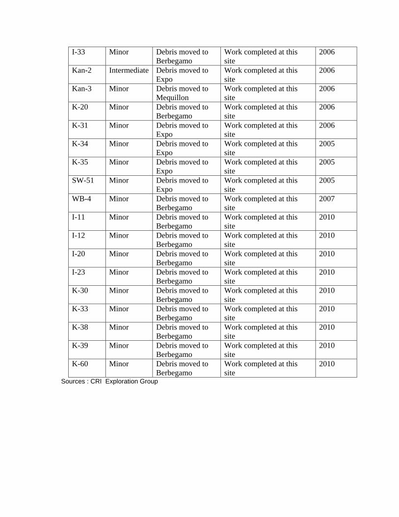
I-33 Minor Debris moved to Berbegamo
Work completed at this site
2006
Kan-2 Intermediate Debris moved to Expo
Work completed at this site
2006
Kan-3 Minor Debris moved to Mequillon
Work completed at this site
2006
K-20 Minor Debris moved to Berbegamo
Work completed at this site
2006
K-31 Minor Debris moved to Expo
Work completed at this site
2006
K-34 Minor Debris moved to Expo
Work completed at this site
2005
K-35 Minor Debris moved to Expo
Work completed at this site
2005
SW-51 Minor Debris moved to Expo
Work completed at this site
2005
WB-4 Minor Debris moved to Berbegamo
Work completed at this site
2007
I-11 Minor Debris moved to Berbegamo
Work completed at this site
2010
I-12 Minor Debris moved to Berbegamo
Work completed at this site
2010
I-20 Minor Debris moved to Berbegamo
Work completed at this site
2010
I-23 Minor Debris moved to Berbegamo
Work completed at this site
2010
K-30 Minor Debris moved to Berbegamo
Work completed at this site
2010
K-33 Minor Debris moved to Berbegamo
Work completed at this site
2010
K-38 Minor Debris moved to Berbegamo
Work completed at this site
2010
K-39 Minor Debris moved to Berbegamo
Work completed at this site
2010
K-60 Minor Debris moved to Berbegamo
Work completed at this site
2010
Sources : CRI Exploration Group
conclusion
The clean-up of old abandoned mining exploration sites voluntarily undertaken by CRI since 2002 resulted in the remediation of more than 50 listed old abandoned sites. This enormous achievement by a small company shows that the exploration and mining industries have goodwill and act locally to protect the environment.
APPENDIX A
LOCATION MAP OF ABANDONED MINING EXPLORATION SITES
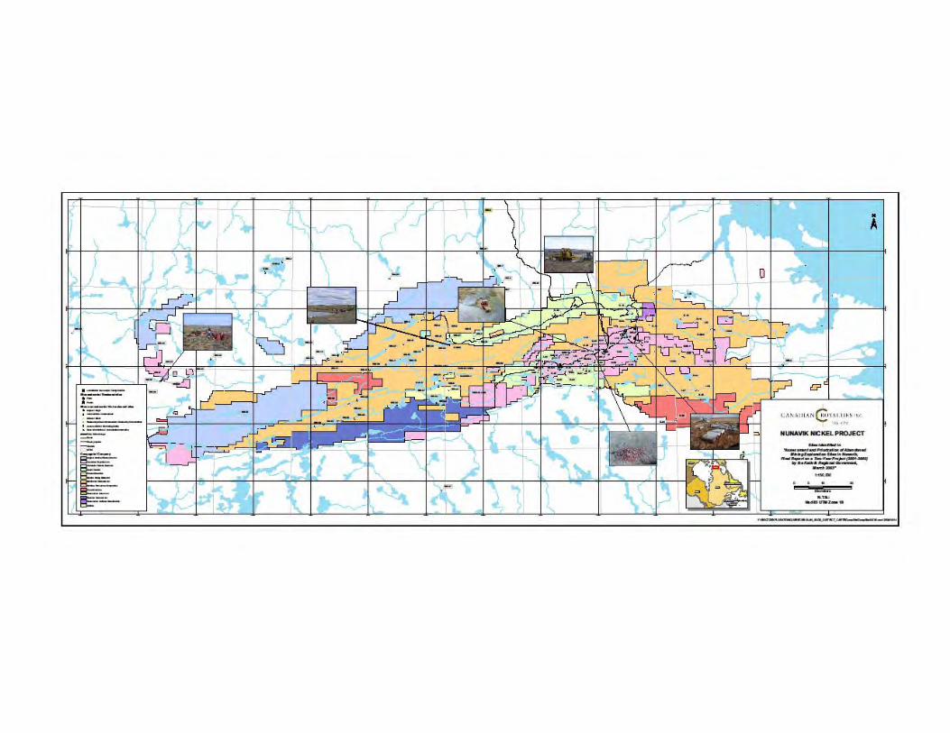
APPENDIX B
LOCATIONS OF CLEAN-UP SITES 2010
Easting Northing Easting Northing
562559 6817075 580188 6825961
563059 6817337 580135 6825832
562886 6817384 579929 6825538
562951 6817164 579355 6825354
567770 6817866 579581 6825360
569660 6818984 579228 6825290
570756 6820883 580296 6826135
570236 6821098 580224 6826023
570667 6821653 583658 6826749
570940 6821190 582956 6827919
571496 6820826 580017 6826184
571524 6820640 580138 6826330
571653 6820794 580618 6826446
571718 6820974 580556 6826381
573095 6821547 580518 6826331
577470 6824442 584372 6827621
578530 6824767 584858 6827437
590097 6831299 584996 6827589
589873 6831860 586363 6831931
570395 6820860 587404 6828920
567766 6820740 587050 6828801
567729 682084 587507 6829055
570316 6822158 591728 6827284
571190 6822140 588659 6828533
573138 6823030 592733 6831128
578015 6823048 590406 6832202
577484 6824003 588984 6831597
578133 6824995 590148 6832122
APPENDIX C
PHOTOGRAPHS
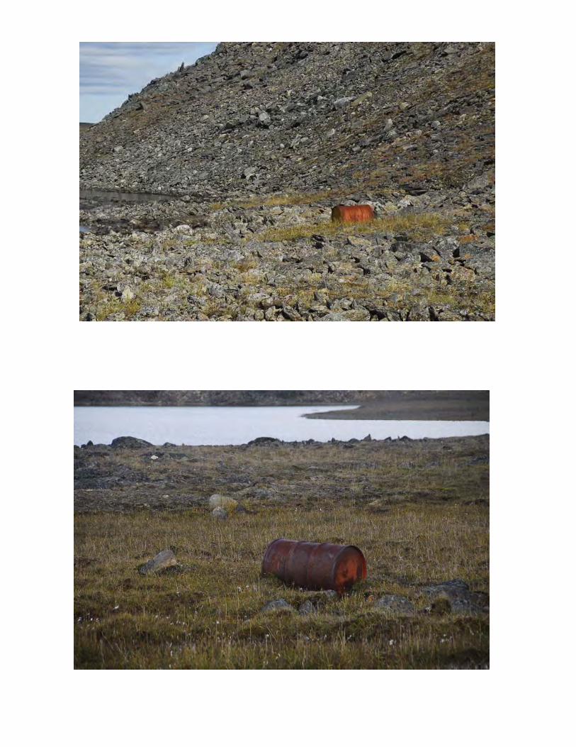
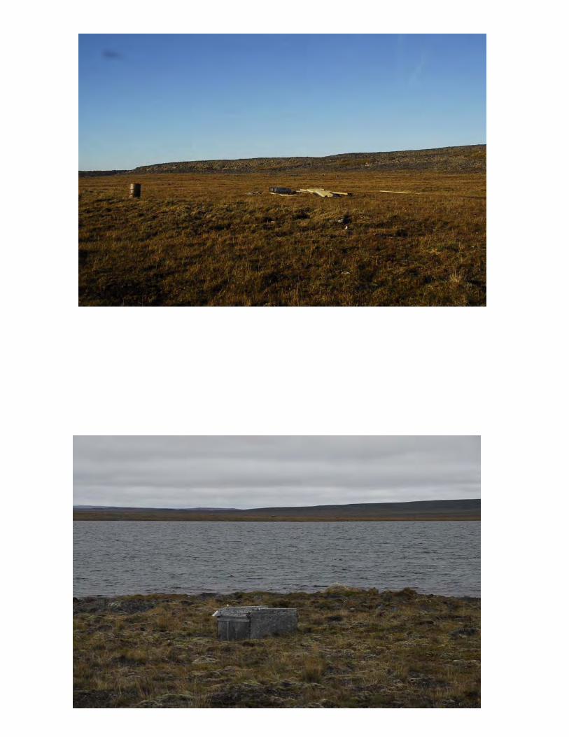
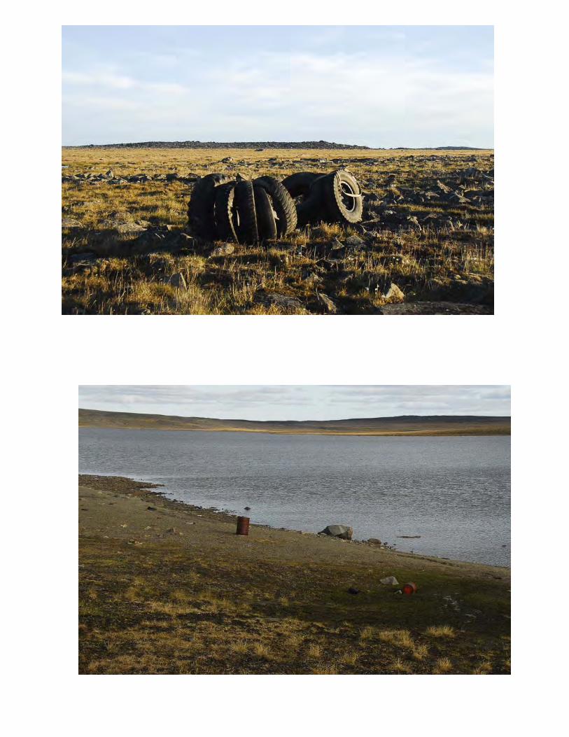
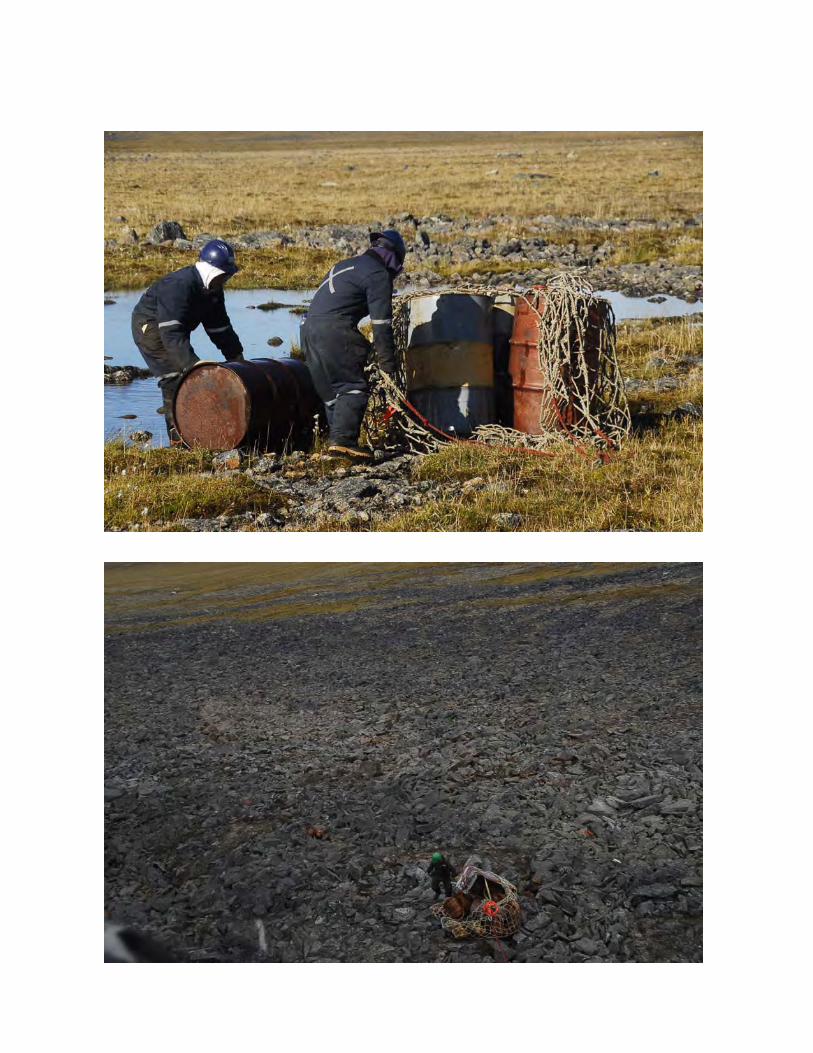

APPENDIX 3
COMMUNITY BULLETIN FROM KRG
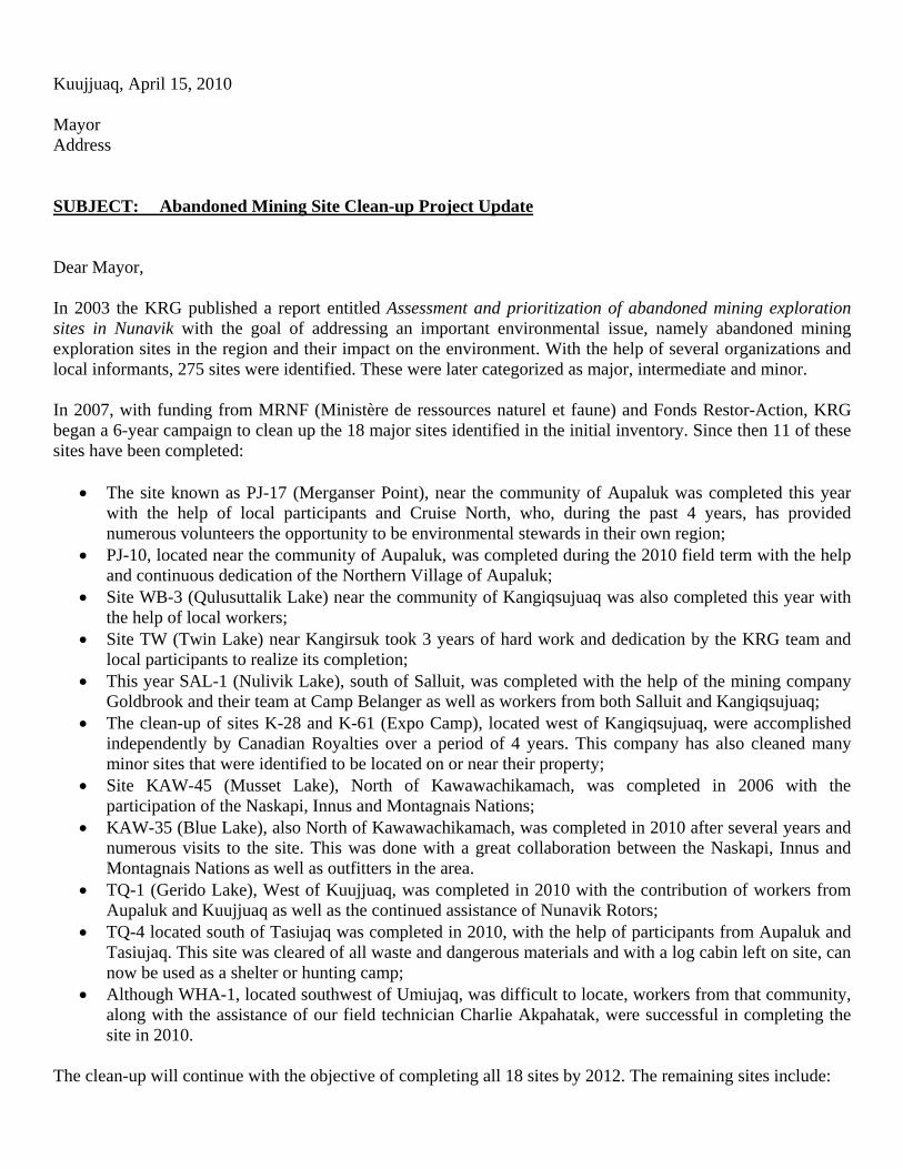
Kuujjuaq, April 15, 2010 Mayor Address SUBJECT: Abandoned Mining Site Clean-up Project Update Dear Mayor, In 2003 the KRG published a report entitled Assessment and prioritization of abandoned mining exploration sites in Nunavik with the goal of addressing an important environmental issue, namely abandoned mining exploration sites in the region and their impact on the environment. With the help of several organizations and local informants, 275 sites were identified. These were later categorized as major, intermediate and minor. In 2007, with funding from MRNF (Ministère de ressources naturel et faune) and Fonds Restor-Action, KRG began a 6-year campaign to clean up the 18 major sites identified in the initial inventory. Since then 11 of these sites have been completed:
The site known as PJ-17 (Merganser Point), near the community of Aupaluk was completed this year with the help of local participants and Cruise North, who, during the past 4 years, has provided numerous volunteers the opportunity to be environmental stewards in their own region;
PJ-10, located near the community of Aupaluk, was completed during the 2010 field term with the help and continuous dedication of the Northern Village of Aupaluk;
Site WB-3 (Qulusuttalik Lake) near the community of Kangiqsujuaq was also completed this year with the help of local workers;
Site TW (Twin Lake) near Kangirsuk took 3 years of hard work and dedication by the KRG team and local participants to realize its completion;
This year SAL-1 (Nulivik Lake), south of Salluit, was completed with the help of the mining company Goldbrook and their team at Camp Belanger as well as workers from both Salluit and Kangiqsujuaq;
The clean-up of sites K-28 and K-61 (Expo Camp), located west of Kangiqsujuaq, were accomplished independently by Canadian Royalties over a period of 4 years. This company has also cleaned many minor sites that were identified to be located on or near their property;
Site KAW-45 (Musset Lake), North of Kawawachikamach, was completed in 2006 with the participation of the Naskapi, Innus and Montagnais Nations;
KAW-35 (Blue Lake), also North of Kawawachikamach, was completed in 2010 after several years and numerous visits to the site. This was done with a great collaboration between the Naskapi, Innus and Montagnais Nations as well as outfitters in the area.
TQ-1 (Gerido Lake), West of Kuujjuaq, was completed in 2010 with the contribution of workers from Aupaluk and Kuujjuaq as well as the continued assistance of Nunavik Rotors;
TQ-4 located south of Tasiujaq was completed in 2010, with the help of participants from Aupaluk and Tasiujaq. This site was cleared of all waste and dangerous materials and with a log cabin left on site, can now be used as a shelter or hunting camp;
Although WHA-1, located southwest of Umiujaq, was difficult to locate, workers from that community, along with the assistance of our field technician Charlie Akpahatak, were successful in completing the site in 2010.
The clean-up will continue with the objective of completing all 18 sites by 2012. The remaining sites include:
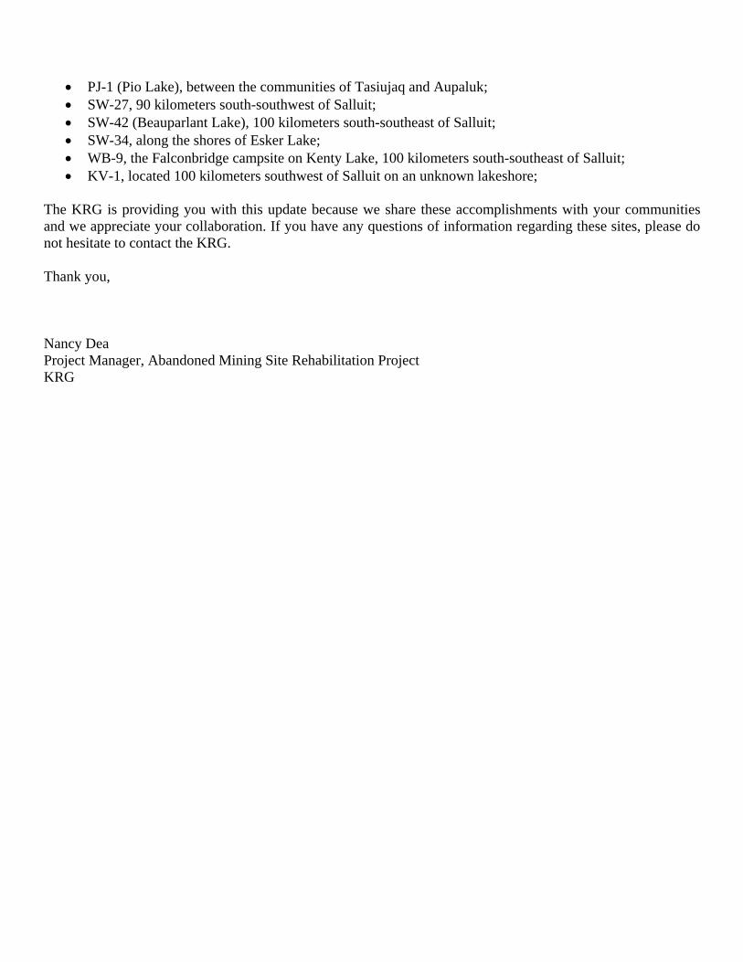
PJ-1 (Pio Lake), between the communities of Tasiujaq and Aupaluk; SW-27, 90 kilometers south-southwest of Salluit; SW-42 (Beauparlant Lake), 100 kilometers south-southeast of Salluit; SW-34, along the shores of Esker Lake; WB-9, the Falconbridge campsite on Kenty Lake, 100 kilometers south-southeast of Salluit; KV-1, located 100 kilometers southwest of Salluit on an unknown lakeshore;
The KRG is providing you with this update because we share these accomplishments with your communities and we appreciate your collaboration. If you have any questions of information regarding these sites, please do not hesitate to contact the KRG. Thank you, Nancy Dea Project Manager, Abandoned Mining Site Rehabilitation Project KRG