Embed Size (px)
Citation preview
SDMS Document
90569
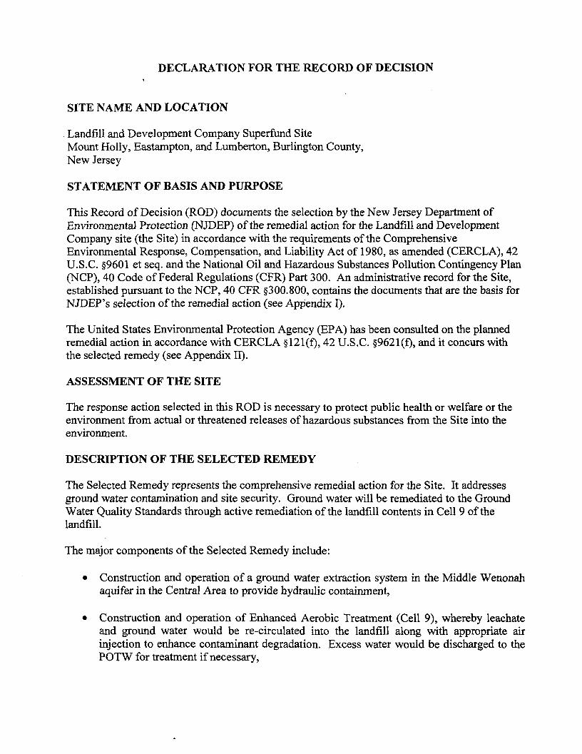
SUPERFUND RECORD OF DECISION
LANDFILL & DEVELOPMENT COMPANY SITEEASTAMPTON, MOUNT HOLLY, AND LUMBERTON TOWNSHIPS
BURLINGTON COUNTYNEW JERSEY
Prepared by: N.J. Department of Environmental ProtectionSite Remediation and Waste Management ProgramBureau of Case ManagementSeptember 2004
DECLARATION FOR THE RECORD OF DECISION
SITE NAME AND LOCATION
Landfill and Development Company Superfund SiteMount Holly, Eastampton, and Lumberton, Burlington County,New Jersey
STATEMENT OF BASIS AND PURPOSE
This Record of Decision (ROD) documents the selection by the New Jersey Department ofEnvironmental Protection (NJDEP) of the remedial action for the Landfill and DevelopmentCompany site (the Site) in accordance with the requirements of the ComprehensiveEnvironmental Response, Compensation, and Liability Act of 1980, as amended (CERCLA), 42U.S.C. §9601 et seq. and the National Oil and Hazardous Substances Pollution Contingency Plan(NCP), 40 Code of Federal Regulations (CFR) Part 300. An administrative record for the Site,established pursuant to the NCP, 40 CFR §300.800, contains the documents that are the basis forNJDEP's selection of the remedial action (see Appendix I).
The United States Environmental Protection Agency (EPA) has been consulted on the plannedremedial action in accordance with CERCLA §121(f), 42 U.S.C. §9621(f), and it concurs withthe selected remedy (see Appendix II).
ASSESSMENT OF THE SITE
The response action selected in this ROD is necessary to protect public health or welfare or theenvironment from actual or threatened releases of hazardous substances from the Site into theenvironment.
DESCRIPTION OF THE SELECTED REMEDY
The Selected Remedy represents the comprehensive remedial action for the Site. It addressesground water contamination and site security. Ground water will be remediated to the GroundWater Quality Standards through active remediation of the landfill contents in Cell 9 of thelandfill.
The major components of the Selected Remedy include:
• Construction and operation of a ground water extraction system in the Middle Wenonahaquifer in the Central Area to provide hydraulic containment,
• Construction and operation of Enhanced Aerobic Treatment (Cell 9), whereby leachateand ground water would be re-circulated into the landfill along with appropriate airinjection to enhance contaminant degradation. Excess water would be discharged to thePOTW for treatment if necessary,
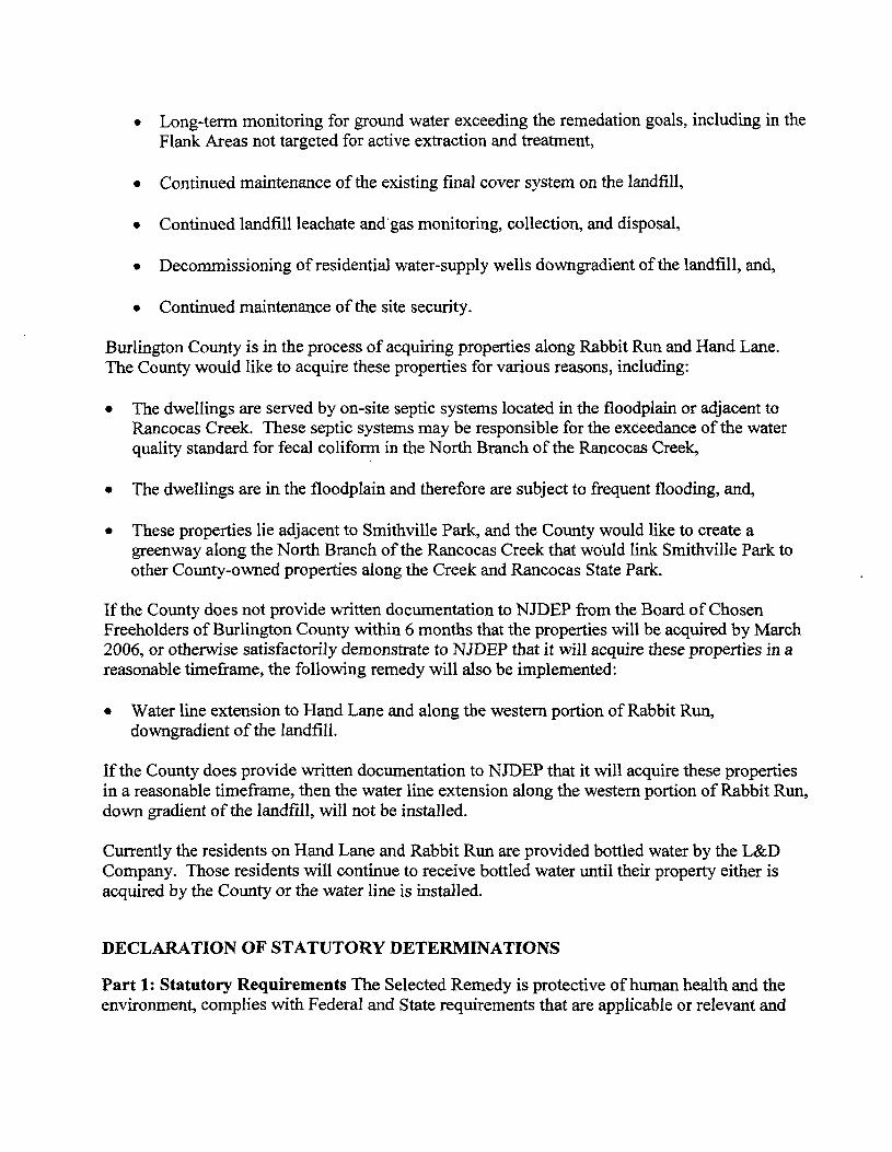
• Long-term monitoring for ground water exceeding the remedation goals, including in theFlank Areas not targeted for active extraction and treatment,
• Continued maintenance of the existing final cover system on the landfill,
• Continued landfill leachate and gas monitoring, collection, and disposal,
• Decommissioning of residential water-supply wells downgradient of the landfill, and,
• Continued maintenance of the site security.
Burlington County is in the process of acquiring properties along Rabbit Run and Hand Lane.The County would like to acquire these properties for various reasons, including:
• The dwellings are served by on-site septic systems located in the floodplain or adjacent toRancocas Creek. These septic systems may be responsible for the exceedance of the waterquality standard for fecal coliform in the North Branch of the Rancocas Creek,
• The dwellings are in the floodplain and therefore are subject to frequent flooding, and,
• These properties lie adjacent to Smithville Park, and the County would like to create agreenway along the North Branch of the Rancocas Creek that would link Smithville Park toother County-owned properties along the Creek and Rancocas State Park.
If the County does not provide written documentation to N JDEP from the Board of ChosenFreeholders of Burlington County within 6 months that the properties will be acquired by March2006, or otherwise satisfactorily demonstrate to NJDEP that it will acquire these properties in areasonable timeframe, the following remedy will also be implemented:
• Water line extension to Hand Lane and along the western portion of Rabbit Run,downgradient of the landfill.
If the County does provide written documentation to NJDEP that it will acquire these propertiesin a reasonable timeframe, then the water line extension along the western portion of Rabbit Run,down gradient of the landfill, will not be installed.
Currently the residents on Hand Lane and Rabbit Run are provided bottled water by the L&DCompany. Those residents will continue to receive bottled water until their property either isacquired by the County or the water line is installed.
DECLARATION OF STATUTORY DETERMINATIONS
Part 1: Statutory Requirements The Selected Remedy is protective of human health and theenvironment, complies with Federal and State requirements that are applicable or relevant and
appropriate to the remedial action (unless justified by a waiver), is cost-effective, and utilizespermanent solutions and alternative treatment (or resource recovery) technologies to themaximum extent practicable.
Part 2: Statutory Preference for Treatment This remedy also satisfies the statutory preferencefor treatment as a principal element of the remedy (i.e., reduces the toxicity, mobility, or volumeof hazardous substances, pollutants, or contaminants as a principal element through treatment).
Part 3: Five-Year Review Requirements Because this remedy will result in hazardoussubstances, pollutants, or contaminants remaining on-site above levels that allow for unlimiteduse and unrestricted exposure, a statutory review will be conducted within five years afterinitiation of remedial action to ensure that the remedy is, or will be, protective of human healthand the environment.
SEP 3 0 2004
Campbell, CDepartment of Eectio
Date
TABLE OF CONTENTS
PAGE
SITE NAME, LOCATION AND DESCRIPTION 1
SITE HISTORY AND ENFORCEMENT ACTIVITIES 1
HIGHLIGHTS OF COMMUNITY PARTICIPATION 3
SCOPE AND ROLE OF ACTION 3
SUMMARY OF SITE CHARACTERISTICS 4
CURRENT AND POTENTIAL FUTURE SITE AND RESOURCE USES 6
SUMMARY OF SITE RISKS 6
REMEDIAL ACTION OBJECTIVES 12*
DESCRIPTION OF REMEDIAL ALTERNATIVES 13
SUMMARY OF COMPARATIVE ANALYSIS OF ALTERNATIVES 17
PRINCIPAL THREAT WASTES 21
SELECTED REMEDY 21
STATUTORY DETERMINATIONS 24
DOCUMENTATION OF SIGNIFICANT CHANGES 25
FIGURES
TABLES
APPENDIX I ADMINISTRATIVE RECORD INDEXAPPENDIX II EPA LETTER OF CONCURRENCEAPPENDIX III RESPONSIVENESS SUMMARY
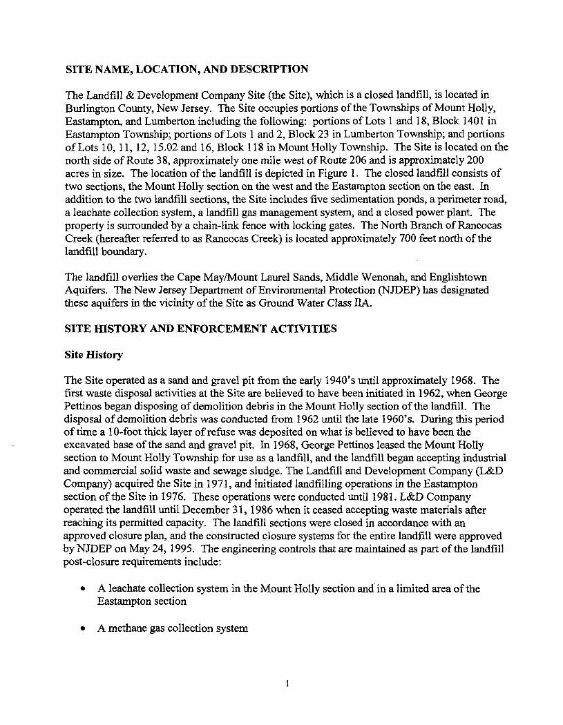
SITE NAME, LOCATION, AND DESCRIPTION
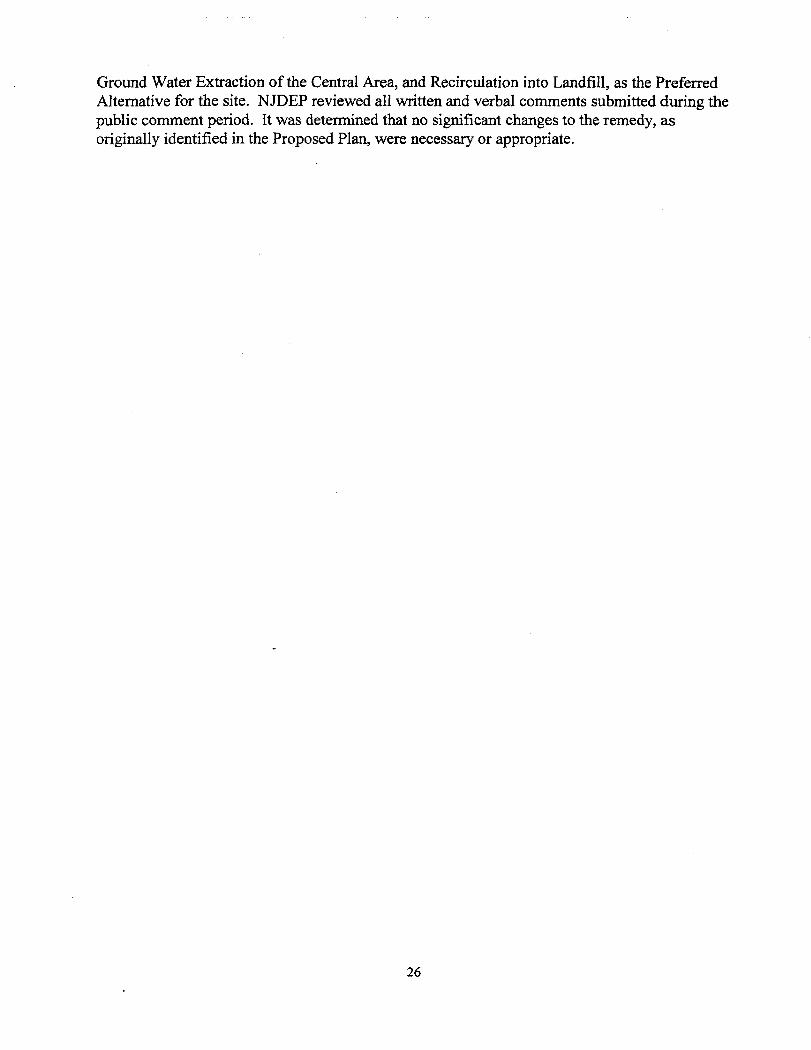
The Landfill & Development Company Site (the Site), which is a closed landfill, is located inBurlington County, New Jersey. The Site occupies portions of the Townships of Mount Holly,Eastampton, and Lumberton including the following: portions of Lots 1 and 18, Block 1401 inEastampton Township; portions of Lots 1 and 2, Block 23 in Lumberton Township; and portionsof Lots 10, 11, 12,15.02 and 16, Block 118 hi Mount Holly Township. The Site is located on thenorth side of Route 38, approximately one mile west of Route 206 and is approximately 200acres in size. The location of the landfill is depicted in Figure 1. The closed landfill consists oftwo sections, the Mount Holly section on the west and the Eastampton section on the east. Inaddition to the two landfill sections, the Site includes five sedimentation ponds, a perimeter road,a leachate collection system, a landfill gas management system, and a closed power plant. Theproperty is surrounded by a chain-link fence with locking gates. The North Branch of RancocasCreek (hereafter referred to as Rancocas Creek) is located approximately 700 feet north of thelandfill boundary.
The landfill overlies the Cape May/Mount Laurel Sands, Middle Wenonah, and EnglishtownAquifers. The New Jersey Department of Environmental Protection (NJDEP) has designatedthese aquifers in the vicinity of the Site as Ground Water Class IIA.
SITE HISTORY AND ENFORCEMENT ACTIVITIES
Site History
The Site operated as a sand and gravel pit from the early 1940's until approximately 1968. Thefirst waste disposal activities at the Site are believed to have been initiated in 1962, when GeorgePettinos began disposing of demolition debris in the Mount Holly section of the landfill. Thedisposal of demolition debris was conducted from 1962 until the late 1960's. During this periodof time a 10-foot thick layer of refuse was deposited on what is believed to have been theexcavated base of the sand and gravel pit. In 1968, George Pettinos leased the Mount Hollysection to Mount Holly Township for use as a landfill, and the landfill began accepting industrialand commercial solid waste and sewage sludge. The Landfill and Development Company (L&DCompany) acquired the Site in 1971, and initiated landfilling operations in the Eastamptonsection of the Site in 1976. These operations were conducted until 1981. L&D Companyoperated the landfill until December 31,1986 when it ceased accepting waste materials afterreaching its permitted capacity. The landfill sections were closed in accordance with anapproved closure plan, and the constructed closure systems for the entire landfill were approvedby NJDEP on May 24, 1995. The engineering controls that are maintained as part of the landfillpost-closure requirements include:
• A leachate collection system in the Mount Holly section and in a limited area of theEastampton section
• A methane gas collection system
• A clay cover system.
Enforcement History and Previous Investigations
On May 15,1976, pursuant to N.J.S.A. 13-.1E-1 etseq.. the NJDEP issued L&D Company anAmended Registration and Stipulation for the operation of a sanitary landfill at the Site. OnSeptember 13, 1982 the NJDEP issued L&D a second Amended Certificate of ApprovedRegistration and Engineering Design Approval. The conditions set forth in paragraphs 3 and 5 ofthe Certificate required that a comprehensive ground water investigation be conducted at the Siteto determine the nature and extent of contamination at the Site and required that a study beundertaken to determine how best to abate or prevent such contamination. L&D soughtadministrative and judicial review of certain provisions of the Amended Certificate that resultedin the issuance of a Second Amended Certificate of Registration and Engineering DesignApproval dated May 2,1984. In 1983, the Site was placed on the National Priorities List (NPL)by EPA based on initial ground water investigations. On June 28,1985 the NJDEP issued L&Da final NJPDES Permit 0033502. The permit required L&D to perform a ground water study andremedy assessment for the Site. The data generated was to be used by the NJDEP to determine ifthere was any potential or actual threat to the public health or safety or damage to theenvironment. In February 1986 L&D Company's consultant prepared a report entitled"Hydrogeologic Investigation and Assessment, L&D Landfill, Mt. Holly, New Jersey." Thisreport included analytical data from ground water monitoring well sampling conducted inFebruary 1985 at or near the Site under the NJPDES permit. The wells that were sampleddemonstrated ground water contamination in the immediate vicinity of the landfill.
On May 30, 1986, pursuant to the Spill Compensation and Control Act, N.J.S.A. 58:10-23.1 If,the NJDEP directed L&D Company to remove or arrange for the removal of such hazardoussubstances in the ground water by providing the NJDEP funds to conduct a remedialinvestigation and feasibility study. On September 30, 1986 the NJDEP awarded a contract to thefirm of Baker/TSA, Inc. to perform a remedial investigation and feasibility study. On July 21,1988 Baker/TSA, Inc. submitted a report that presented data showing that hazardous substanceswere discharged into the ground water.
In 1988, the L&D Company entered into an Administrative Consent Order (AGO) to fund aRemedial Investigation/Feasibility Study (RI/FS). A Phase IRI Report was issued in July 1988.The L&D Company and NJDEP entered into a second AGO in July 1990 to complete a Phase IIRI/FS. The Phase II RI/FS consisted of three volumes: (1) Remedial Investigation, January 1994;(2) Feasibility Study, September 1993; and (3) Risk Assessment, August 1993. A series ofagency comments precipitated additional field work, described in the Phase II RI Addendum,September 1995.
Beginning in June 1997, the L&D Company, in consultation with NJDEP and EPA, updated andaugmented previous Site reports. This work was performed by GeoTrans, Inc. (previouslyknown as "HSI GeoTrans"). The resulting documents were:
• Updated Well Survey Report (HSI GeoTrans, December 29,1999)
• Revised Ground Water Remedial Investigation and ORC Pilot Test Report (HSIGeoTrans, June 12,2000) (referred to as the RI Report)
• Revised Ecological Risk Assessment Report (HSI GeoTrans, April 18, 2000, plusAddendum dated December 15,2000)
• Revised Human Health Risk Assessment (GeoTrans, May 16,2001)
• Revised Feasibility Study Report (GeoTrans, August 8,2001) (referred to as the FSReport)
HIGHLIGHTS OF COMMUNITY PARTICIPATION
The documents referenced above have been placed in the repository. The Proposed Plan, alongwith notice of the availability of the RI/FS, was released to the public on May 20, 2004. Thedocuments and the plan were made available to the public in both the Administrative Record andat information repositories maintained at the Burlington County Library and at NJDEP's Trentonoffice.
The notice of availability was published in the Burlington County Times on May 17,2004 andthe Courier Post on May 20, 2004. A public comment period was originally scheduled from May20 through June 21, 2004, however it was extended until July 21, 2004 at the request of thepublic. A public meeting was held in Westampton, New Jersey on May 24,2004. At thismeeting, representatives from NJDEP, USEPA, the L&D Company and GeoTrans, Inc. answeredquestions about the Site and the remedial alternatives under consideration. In addition, a meetingwas held with the Rancocas Creek Association on July 15,2004 with NJDEP representatives.
Based on the comments received at the May 24,2004 meeting, the July 15, 2004 meeting, andduring the public comment period, the local community and public officials generally supportedthe agencies' preferred alternative presented in the Proposed Plan. Public comment focused onthe water line extension as well as specific issues related to the remedy. Detailed responses tothese comments are contained in the Responsiveness Summary.
SCOPE AND ROLE OF ACTION
NJDEP has addressed much of the Site under the closure and post-closure provisions of the NewJersey Solid Waste Regulations, NJ.A.C. 7:26-2A.9, through the construction of closure systemsfor the entire landfill, approved by NJDEP in 1995. The engineering controls on the landfill aremaintained as part of the landfill's post-closure requirements. The scope and role of this actionaddresses the only outstanding issue for this Site, the ground water that is contaminated from thelandfill. The remedy selected in this ROD represents a long-term comprehensive remedy toaddress on-site and off-site ground water contamination. The primary objective of the selectedremedy is to reduce contaminant levels in affected media, specifically ground water, to levels thatare protective of human health and the environment. This is the final remedy for the Site.
SUMMARY OF SITE CHARACTERISTICS
Site Hydrology
Surface water features in the vicinity of the Site are illustrated on Figure 1. The Rancocas Creekis located north of the landfill and flows in a westerly direction. A man-made canal, knownlocally as the Smithville Canal, originates at Smithville Lake, and flows (when not stagnant ordry) to the west/northwest. Surface drainage at the landfill is controlled by the topography and asurface water runoff collection system that includes five sedimentation ponds. There are somelocations between the landfill and Rancocas Creek where ground water seasonally discharges toland surface (referred to as "ground water seeps"). These features should not be confused withseeps of liquid leaching from the landfill itself, or "leachate seeps", which are not present.During wet periods numerous ground water seeps have been observed between the landfill andRancocas Creek, some with standing water and others flowing. However, during dry periods theground water seeps have been observed to be dry.
Site Geology/Hydrogeology
The L&D Site is divided into five hydrogedlogic units based on similar hydrologic properties.The units, in descending order from the ground surface, are as follows:
• Mount Laurel/Cape May Sand (MLCMS) aquifer• Upper Wenonah confining unit• Middle Wenonah aquifer• Marshalltown/Lower Wenonah confining unit• Englishtown aquifer
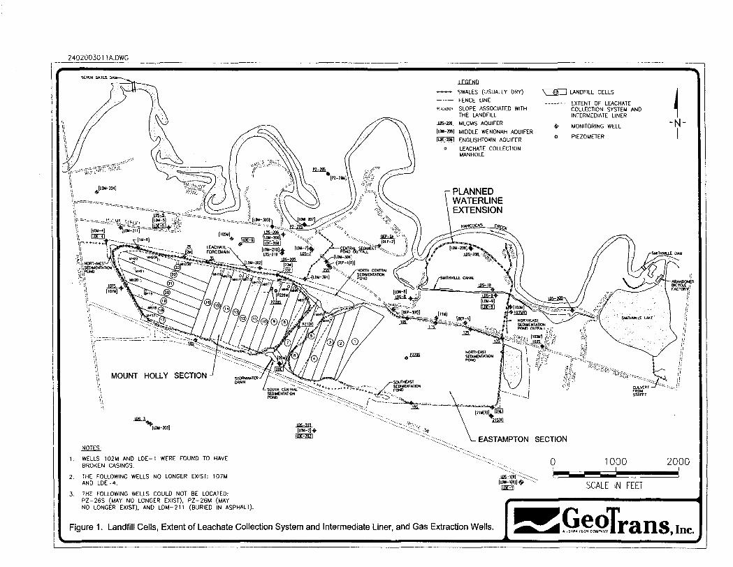
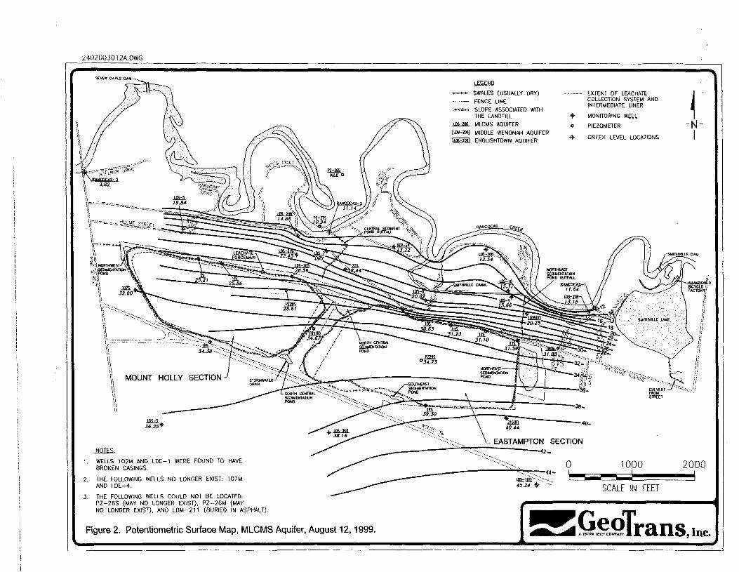
Ground water flow in all three aquifers is northward, towards Rancocas Creek (see Figures 2 to4). The Middle Wenonah and MLCMS aquifers discharge into Rancocas Creek. At times, theMLCMS aquifer north of the Eastampton section of the landfill may also discharge intoSmithville Canal. Ground water also discharges seasonally as ground water seeps. Verticalhydraulic gradients are downward to the Englishtown aquifer south of the landfill, and upwardfrom the Englishtown aquifer north of the landfill (with an increasing upward gradient towardsRancocas Creek).
Based on a comparison of historical ground water levels versus the bottom elevation of landfillcontents, ground water is likely in contact with the refuse in the northwestern portion of theMount Holly section. There are several other areas with the potential for ground water toperiodically be in contact with the refuse.
Ground Water Impacts
Based on the RI Report, portions of the MLCMS aquifer and Middle Wenonah aquifer have beenimpacted by the landfill. However, ground water hi the underlying Englishtown aquifer has notbeen impacted by the landfill.
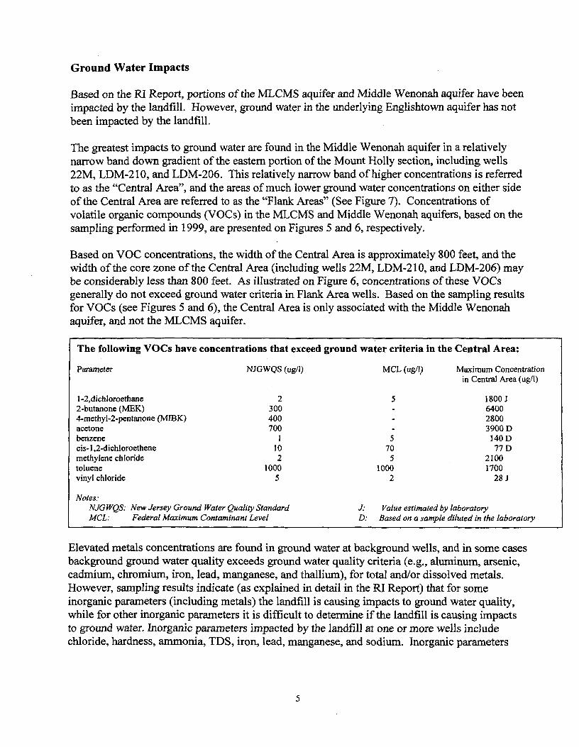
The greatest impacts to ground water are found in the Middle Wenonah aquifer in a relativelynarrow band down gradient of the eastern portion of the Mount Holly section, including wells22M, LDM-210, and LDM-206. This relatively narrow band of higher concentrations is referredto as the "Central Area", and the areas of much lower ground water concentrations on either sideof the Central Area are referred to as the "Flank Areas" (See Figure 7). Concentrations ofvolatile organic compounds (VOCs) in the MLCMS and Middle Wenonah aquifers, based on thesampling performed in 1999, are presented on Figures 5 and 6, respectively.
Based on VOC concentrations, the width of the Central Area is approximately 800 feet, and thewidth of the core zone of the Central Area (including wells 22M, LDM-210, and LDM-206) maybe considerably less than 800 feet. As illustrated on Figure 6, concentrations of these VOCsgenerally do not exceed ground water criteria in Flank Area wells. Based on the sampling resultsfor VOCs (see Figures 5 and 6), the Central Area is only associated with the Middle Wenonahaquifer, and not the MLCMS aquifer.
The following VOCs have concentrations that exceed
Parameter NJGWQS (ug/1)
l-2,dichloroethane 22-butanone (MEK) 3004-methyl-2-pentanone (MIBK) 400acetone 700benzene 1cis- 1 ,2-dichloroethene 1 0methylene chloride 2toluene 1000vinyl chloride 5
Notes:NJGWQS: New Jersey Ground Water Quality StandardMCL: Federal Maximum Contaminant Level
ground water criteria in the Central Area:
MCL (ug/1) Maximum Concentrationin Central Area (ug/1)
5 1800 J640028003900 D
5 HOD70 77 D5 2100
1000 17002 28 J
J: Value estimated by laboratoryD: Based on a sample diluted in the laboratory
Elevated metals concentrations are found in ground water at background wells, and in some casesbackground ground water quality exceeds ground water quality criteria (e.g., aluminum, arsenic,cadmium, chromium, iron, lead, manganese, and thallium), for total and/or dissolved metals.However, sampling results indicate (as explained in detail in the RI Report) that for someinorganic parameters (including metals) the landfill is causing impacts to ground water quality,while for other inorganic parameters it is difficult to determine if the landfill is causing impactsto ground water. Inorganic parameters impacted by the landfill at one or more wells includechloride, hardness, ammonia, TDS, iron, lead, manganese, and sodium. Inorganic parameters
that may or may not be impacted by the landfill include aluminum, arsenic, cadmium, andthallium.
CURRENT AND POTENTIAL FUTURE SITE AND RESOURCE USES
Site uses: The Site is currently a closed landfill which is surrounded by a chain-link fence withlocking gates. At this point in time, there are no plans for future use of the property other than tomaintain the landfill. There have been inquiries from the surrounding community whether theproperty could be used for recreational open space (e.g., ballfields), but such a determinationwould not be made until after the effectiveness of the reinjection system has been monitored, hithe event that the property is proposed for recreational use, L&D Company would need to ensurethat it would be in compliance with the closure plan for the landfill.
Ground water uses: The recent well survey identified 18 existing wells hydraulically downgradient of the landfill. Of the 18 wells, only two are reportedly used for drinking water. Thesewells, both located on Wollner Drive, are completed in the Englishtown aquifer, which has notbeen impacted by the Site contamination. The remaining 16 wells are reportedly used foragriculture or general household (non-potable) purposes. Other than the properties withEnglishtown aquifer wells on Wollner Drive, all areas down gradient of landfill have access topublic water except homes along Rabbit Run and Hand Lane, where the residents are currentlysupplied with bottled drinking water and where a water line extension is currently planned ifBurlington County does not acquire those properties.
SUMMARY OF SITE RISKS
Baseline human health and ecological risk assessments were conducted to evaluate the potentialfor current and future impacts of site-related contaminants on receptors visiting, utilizing orinhabiting the Site. Under baseline conditions, there are certain exposure scenarios whichpresent unacceptable human health risk.
Human Health Risk Assessment
As part of the RI/FS for the site, a Human Health Risk Assessment (HHRA) was conducted toestimate the potential current and future effects of site contaminants on human health. TheHHRA estimates the human health risk which could result from the contamination at the site ifno remedial action were taken, and without institutional controls.
A four-step process is utilized for assessing the site-related human health risks for a reasonablemaximum exposure scenario: Hazard Identification - identifies the chemicals of potentialconcern (COPCs) at the site based on several factors such as toxicity, frequency of detection, andconcentration; Exposure Assessment - estimates the magnitude of actual and/or potential humanexposure, the frequency and duration of these exposures, and the pathways (e.g., ingestingcontaminated soil) by which humans are potentially exposed; Toxicity Assessment - determinesthe types of adverse health effects associated with chemical exposures, and the relationshipbetween magnitude of exposure (dose) and severity of adverse effects (response); Risk
Characterization - summarizes and combines outputs of the exposure and toxicity assessmentsto provide a quantitative assessment of site-related risks.
The current and future use of the site property is as a landfill in the risk assessment. The currentand likely future uses of the neighboring properties are commercial/light industrial, andresidential. The HHRA focuses on exposure to contaminants in on-site sedimentation ponds, inthe ground water down-gradient of the site, and in surface water bodies which receive groundwater discharges.
Hazard Identification
In this step, chemicals of potential concern (COPCs) were identified based on historical detectionat the site, frequency of detection, potential toxicity, carcinogenic potential and classification,and a concentration-toxicity screen. This process, which is consistent with current EPA guidancefor conducting human health risk assessments, is thoroughly described in Section 4 of theRevised Human Health Risk Assessment report.
Samples were collected from all media suspected to be impacted by the site, specifically groundwater (MLCMS aquifer and the Central Area and the Eastern and Western Flank Areas of theMiddle Wenonah aquifer), ground water seeps, surface water and sediment from RancocasCreek, Smithville Canal and four sedimentation ponds (northeast, northcentral, southeast, andsouthcentral sedimentation ponds). COPCs were identified through a process that includedscreening against appropriate risk-based concentrations and consideration of frequency ofdetection.
As only the Central Area of the Middle Wenonah aquifer is associated with unacceptable levelsof risk, this summary of the risk assessment will focus on that area. Chemicals that were retainedas COPCs in the Central Area of the Middle Wenonah aquifer include arsenic, 1,2-dichloroethane, 2-butanone, 4-methyl-2-pentanone, acetone, benzene, methylene chloride,toluene, and vinyl chloride.
Exposure Assessment
Based on the current and likely future use of the site, potential human receptor scenariosevaluated in the HHRA are recreational exposure through incidental ingestion of and dermalcontact with surface water and sediment in Rancocas Creek, Smithville Canal, the foursedimentation ponds and the ground water seeps, and ingestion offish harvested from RancocasCreek. Also, potential exposure to ground water was assessed in a residential scenario under theassumption that ground water would be used as a potable water supply. The evaluation of thismedium considered exposure through ingestion of and dermal contact with ground water andinhalation of volatiles from ground water. A complete discussion of the Exposure Assessment,including all exposure assumptions used for the scenarios identified, can be found in Section 5 ofthe Revised Human Health Risk Assessment Report.
Using this information, the "reasonable maximum exposure" scenario, which identifies thehighest level of human exposure that could reasonably be expected to occur, was evaluated.
An exposure point concentration (EPC) was developed for each contaminant in the media. Datawere evaluated to determine whether they were normally or lognormally distributed. Inaccordance with EPA guidance, the EPC was the 95 percent upper confidence limit (95% UCL)of the arithmetic mean of the log-transformed data. For those chemicals where the maximumdetected concentration was less than the 95% UCL, or where the paucity of the data set wouldpreclude calculation of a 95% UCL, the maximum detected concentration was used as the EPC.EPC values for each contaminant and each media can be found in the RI report. EPCs for thosechemicals associated with unacceptable levels of risk in the Central Area of the Middle Wenonahaquifer can be found in Table 1.
Toxicity Assessment
The toxicity assessment determines the types of adverse health effects associated with chemicalexposures, and the relationship between the dose of a chemical and the response elicited. Twodistinct types of health effects are considered, carcinogenic effects, and noncarcinogenic, orsystemic effects. A comprehensive presentation of the toxicity assessment can be found inSection 6 of the Revised Human Health Risk Assessment Report.
Toxicity data for the HHRA were provided by the Integrated Risk Information System (IRIS)database, the Health Effects Assessment Summary Tables (HEAST), and the National Center forEnvironmental Assessment (NCEA). This information is presented in Tables 6-1 through 6-4 ofthe RI Report.
Toxicity information for the chemicals of concern in the Central Area of the Middle Wenonahaquifer can be found in Tables 2 (carcinogenic toxicity data) and 3 (noncarcinogenic toxicitydata).
Risk Characterization
The baseline risk assessment estimates the potential risk and hazards to human health if noremedial action occurs. A more detailed discussion of the cumulative risks and hazardsassociated with the Landfill and Development Site can be found in Section 7 of the RevisedHuman Health Risk Assessment Report.
For carcinogens, risks are generally expressed as the incremental probability of an individualdeveloping cancer over a lifetime as a result of exposure to a carcinogen. Excess lifetime cancerrisk is calculated from the following equation:
Risk = LADD x SF
where:Risk = a unitless probability (1 x 10"4) of an individual developing cancer
LADD = lifetime average daily dose averaged over 70 years (mg/kg-day)SF = slope factor, expressed as (mg/kg-day)"1
These risks are probabilities that usually are expressed in scientific notation (such as 1 x 10"4).An excess lifetime cancer risk of 1 x 10"4 indicates that one additional incidence of cancer mayoccur in a population of 10,000 people who are exposed under the conditions identified in theassessment. As stated in the National Contingency Plan, EPA's acceptable risk range for site-related exposures is 10"4 to 10"6. The State of New Jersey has an acceptable risk level of 1 x 10"6.
The potential for noncarcinogenic effects is evaluated by comparing an exposure level over aspecified time period, such as a 30-year period of exposure, with a reference dose (RfD) derivedfor a similar exposure period. An RfD represents a level that an individual may be exposed tothat is not expected to cause any deleterious health effect. The ratio of the exposure dose to thereference dose is called a hazard quotient (HQ). An HQ of less than or equal to 1 indicates thatthe exposure dose is less than or equal to the reference dose, and that noncarcinogenic healtheffects are unlikely to occur. The hazard index (HI) for an exposure pathway is generated bysumming the HQs for all chemicals of concern for a singular pathway. An HI of less than orequal to 1 indicates that noncarcinogenic health effects are unlikely to occur. An HI of greaterthan 1 indicates the likelihood that site-related exposures may result in noncarcinogenic healtheffects.
The HQ is calculated as follows:
HQ = ADD/RED
where:HQ = hazard quotientADD = average daily dose (mg/kg-day)RfD = reference dose (mg/kg-day)
The ADD and the RfD will represent the same exposure period (i.e., chronic, subchronic, oracute).
As shown in Table 4, the cumulative carcinogenic risk from exposure to ground water hi theCentral Area of the Middle Wenonah aquifer is 1.7 x 10"2 for the adult/child resident. For thispopulation, the following chemicals have been identified as risk drivers; that is, the risk fromexposure through all evaluated pathways exceeds the upperbound of EPA's acceptable level of 1x 10"4: arsenic, 1,2-dichloroethane, benzene, methylene chloride, and vinyl chloride. It should benoted that the other COPCs do contribute to the cumulative risk, but not at a level greater than 1x 10"4. All carcinogenic risks from exposure to the other media that have been investigated arewithin EPA's acceptable levels of carcinogenic risk.
Presented in Table 5, the noncarcinogenic hazard index from exposure to contaminants in theCentral Area of the Middle Wenonah aquifer through ingestion, inhalation, and dermal contact is
230 for the adult/child resident. The risk drivers for this population are: arsenic, 1,2-dichloroethane, 2-butanone,4-methyl-2-pentanone, acetone, benzene, methylene chloride,toluene, and vinyl chloride. Therefore, the HQ for each of these chemicals exceeds the EPAbenchmark of an HQ of 1. It should be noted that the other COPCs do contribute to thecumulative hazard, but not at a level which exceeds EPA's acceptable HQ of 1. HI valuesestimated for exposure to other media that have been investigated are below the acceptable HI of1.
A complete list of the cancer risks and noncancer HI values for all contaminants of potentialconcern in all media can be found in Tables 7-1 through 7-37 in the Revised Human Health RiskAssessment Report.
Based on these risk estimates driven by the presence of arsenic, 1,2-dichloroethane, 2-butanone,4-methyl-2-pentanone, acetone, benzene, methylene chloride, toluene, and vinyl chloride in theground water of the Central Area of the Middle Wenonah aquifer, the response action selected inthis ROD is necessary to protect public health or welfare of the environment from actual orthreatened releases of hazardous substances into the environment.
Discussion of Uncertainties
The procedures and inputs used to assess risks in this evaluation, as in all such assessments, aresubject to a wide variety of uncertainties. In general, the main sources of uncertainty include:
1. environmental chemistry sampling and analysis2. environmental parameter measurement3. fate and transport modeling4. exposure parameter estimation5. toxicological data.
Uncertainty in environmental sampling arises in part from the potentially uneven distribution ofchemicals in the media sampled. Consequently, there is significant uncertainty as to the actuallevels present. Environmental chemistry-analysis error can stem from several sources includingthe errors inherent in the analytical methods and characteristics of the matrix being sampled.Uncertainties in the exposure assessment are related to estimates of how often an individualwould actually come in contact with the chemicals of concern, the period of time over whichsuch exposure would occur, and in the models used to estimate the concentrations of thechemicals of concern at the point of exposure.
Uncertainties in toxicological data occur in extrapolating both from animals to humans and fromhigh to low doses of exposure, as well as from the difficulties in assessing the toxicity of amixture of chemicals. These uncertainties are addressed by making conservative assumptionsconcerning risk and exposure parameters throughout the assessment. As a result, the riskassessment provides upper-bound estimates of the risks to populations near the site, and is highlyunlikely to underestimate actual risks related to the site.
10
Summary of Human Health Risks
The New Jersey Brownfield and Contaminated Site Remediation Act, N.J.S.A. 58:10B-1, et.seq., has set the acceptable cancer risk for human carcinogens at 1 x 10"6 (one-in-one-million)and acceptable non-carcinogenic risk for any given effect to a value not to exceed an HI of 1.0.These established acceptable risk values are for any particular contaminant and not for thecumulative effects of more than one contaminant at a Site.
Significant risks to human health are indicated for ground water in the Central Area of theMiddle Wenonah aquifer. In the Flank Areas of the Middle Wenonah aquifer, potential risks tohuman health were calculated, but were generally associated with a small number ofmeasurements for total arsenic that appear to be naturally occurring and, therefore, not a result ofthe landfill. This is also the case with the potential risks associated with ground water in theMLCMS aquifer, ground water seeps, Rancocas Creek, Smithville Canal, and the sedimentationponds.
Ecological Risk Assessment (ERA)
A four-step process is utilized for assessing site-related ecological risks for a reasonablemaximum exposure scenario: Problem Formulation - a qualitative evaluation of contaminantrelease, migration, and fate; identification of contaminants of concern, receptors, exposurepathways, and known ecological effects of the contaminants; and selection of endpoints forfurther study. Exposure Assessment - a quantitative evaluation of contaminant release, migration,and fate; characterization of exposure pathways and receptors; and measurement or estimation ofexposure point concentrations. Ecological Effects Assessment - literature reviews, field studies,and toxicity tests, linking contaminant concentrations to effects on ecological receptors. RiskCharacterization - measurement or estimation of both current and future adverse effects.
Primary assessment endpoints evaluated in the ecological risk assessment were:
• Survival, growth, and reproduction of benthic communities in Rancocas Creek andSmithville Canal.
• Survival, growth, and reproduction offish communities in Rancocas Creek andSmithville Canal.
• Survival, growth, and reproduction of avian piscivores (i.e., birds that eat fish) foraging inRancocas Creek and Smithville Canal.
Surface water and sediment concentrations in the ponds/outfalls and ground water seeps werealso compared to appropriate criteria/standards and background results.
Sediment and surface water data, supplemented by exposure modeling for avian piscivores, wereutilized to evaluate ecological effects to the assessment endpoints. Sediment monitoring datawere used to evaluate exposures to benthics, while surface water monitoring data were used to
11
evaluate exposures to fish. Surface water monitoring data and bioaccumulation models wereused to estimate dietary intakes to avian piscivores. Available toxicity criteria, standards, andtoxicity data from the literature were utilized to characterize ecological effects. Potentialecological risks to the assessment endpoints were characterized by integrating the results of theexposure assessment with the toxicity data. Concentrations measured adjacent to the landfillwere compared with concentrations measured at background locations (and in some cases,concentrations in ground water), to evaluate if the landfill is causing or contributing significantlyto ecological risk.
The quantitative ecological risk assessment indicated potential risk to some ecological receptors(e.g., potential impacts to avian piscivores from selenium in surface water and potential impactsto benthics from silver in sediments). However, the data strongly suggest that the L&D landfillis not causing or adding to any ecological risks. The stressors to ecology of the Site vicinity aremost likely: 1) naturally occurring high levels of heavy metals; and 2) anthropogenic activitiesnot associated with the landfill (i.e., residential development and activity) that would lead toincreased non-point source loadings into surface water bodies.
REMEDIAL ACTION OBJECTIVES
Remedial action objectives (RAOs) are specific goals to protect human health and theenvironment. These objectives are based on available information and standards, such asapplicable or relevant and appropriate requirements (ARARs), NJDEP's Ground Water QualityStandards (GWQS), and the Federal Maximum Contaminant Levels (MCLs). The RAOs areintended to mitigate the health threat posed by the ingestion of ground water and direct contactwith landfill contents.
The Feasibility Study (FS) evaluated remedial alternatives for the ground water in the CentralArea, and also included remedial alternatives for ground water in the Central Area plus the FlankAreas. The RI also determined that landfill Cell 9 (see Figure 1) is likely the source of theconstituents identified in the Central Area. Therefore, active remediation of landfill contents inCell 9 was also evaluated in the FS. Based on the results of the Human Health Risk Assessmentand the Ecological Risk Assessment, no active remediation is warranted for surface water orsediments in Rancocas Creek, Smithville Canal, sediment ponds/outfalls, or ground water seeps.
Landfill Contents
For the landfill contents, the primary remedial action objective is to maintain the existingengineering controls that accomplish the following:
• Prevent direct contact with landfill contents
• Reduce leaching of constituents to ground water over time
• Control surface water runoff and erosion
12
• Control landfill gas migration.
A secondary remedial action objective for landfill contents is to reduce the mass, toxicity, ormobility of potentially hazardous constituents in Cell 9, if feasible.
Ground Water«
For ground water, remedial action objectives are the following:
• Prevent human consumption of ground water from the MLCMS and Middle Wenonahaquifers between the landfill and Rancocas Creek
• Achieve remediation goals established for ground water in the MLCMS and MiddleWenonah aquifers
• Avoid and/or minimize negative impacts to human health or the environment (e.g., thewetlands) caused by active remedial measures.
NJDEP has identified remediation goals for the ground water at the L&D Site as the federaldrinking water standards or the New Jersey Ground Water Quality Standards. The moreconservative of the two standards would be used as the remediation goal. A summary of thesestandards can be found in Table 6 (for VOCs) Table 7 (for metals) and Table 8 (for otherinorganic parameters). The remediation goals listed include on these tables are chemical-specificARARs for the Site.
Although the goal is to achieve the remediation goals in ground water, certain factors (e.g., highbackground concentrations of metals) make it unclear whether this goal can be achieved for allparameters.
DESCRIPTION OF REMEDIAL ALTERNATIVES
CERCLA §121(b)(l), 42 U.S.C. §9621 (b)(l) mandates that a remedial action must be protectiveof human health and the environment, cost effective, and utilize permanent solutions andalternative treatment technologies or resource recovery technologies to the maximum extentpracticable. Section 121(b)(l) also establishes a preference for remedial actions that employ, as aprincipal element, treatment to permanently and significantly reduce the volume, toxicity ormobility of the hazardous substances, pollutants and contaminants at a Site. CERCLA §121(d),42 U.S.C. §9621 (d), further specifies that a remedial action must attain a level or standard ofcontrol of the hazardous substances, pollutants and contaminants, which at least attains ARARsunder federal and state laws, unless a waiver can be justified pursuant to CERCLA §121(d) (4),42 U.S.C. §9621 (d)(4).
Based on the information contained in the RI and FS Reports, the Human Health RiskAssessment, and the Ecological Risk Assessment, the Proposed Plan evaluated, in detail, five
13
remedial alternatives for the Site. All remedial alternatives, except Alternative 1 included thecommon elements that are discussed below.
Common Elements of Active Remedial Alternatives
All the alternatives require maintenance of the landfill as directed in the approved landfill closureplan, which is expected to satisfy the RAOs with respect to the landfill contents (with theexception of achieving contaminant reduction in Cell 9). The active alternatives (Alternatives 2through 5) discussed below include common components. All active alternatives would requirethe decommissioning of residential wells down gradient of the landfill, water use restrictions,development of a Classification Exception Area (CEA) between the landfill and Rancocas Creek,and establishment of a long-term ground water monitoring program which will address the RAOsfor ground water. The long-term ground water monitoring plan will determine whether theremediation goals for ground water are being achieved and ensure the protectiveness of theremedy. In addition, a water line extension down gradient of the landfill will be installed ifBurlington County does not provide NJDEP with written documentation from the Board ofChosen Freeholders of Burlington County within 6 months that the properties along Rabbit Runand Hand Lane will be acquired by March 2006, or otherwise satisfactorily demonstrate toNJDEP that it will acquire these properties in a reasonable timeframe.
Remedial Alternatives
Alternatives for active remediation of ground water in the Flank Areas were developed in the FS,but were not carried forward into the combined remedial alternatives for several reasons. First,as discussed in detail in the FS report, impacts to ground water due to the landfill are minimal inthe Flank Areas and, therefore, active remediation in the Flank Areas would not significantly addto the effectiveness of the overall remedy. Second, the implementability of remedies that includethe Flank Areas is considered low compared to remedies for the Central Area, because remedialalternatives involving ground water extraction for the entire Site plume (including the FlankAreas) require a much greater pumping rate (as much as 200 gallons per minute (200 gprn)) thanfor alternatives for the Central Area (30 gpm), and the result is a much greater potential fornegative impacts to wetlands when the Flank Areas are included. Ground water modelingconducted as part of the FS indicates as much as three feet of drawdown might occur beneathwetlands down gradient of the Eastampton section of the landfill for remedial alternativesinvolving ground water extraction for the entire Site plume (including the Flank Areas),compared to less than 0.5 feet of drawdown near wetlands down gradient of the Central Area inthe alternatives with extraction only in the Central Area. Also, with 200 gpm of total extraction(for the entire Site plume), the discharge option to the Publicly Owned Treatment Works(POTW) appears infeasible, and the implementability of other treatment/discharge options thatmeet all discharge standards to surface water or ground water is considered to be low.
After comparing the various on-Site and off-Site ground water treatment and disposal options,only the POTW was retained to address extracted ground water (or excess extracted water forAlternative 3).
14
The contaminant levels in the Flank Areas are expected to decline slowly over time, throughdegradation processes in the ground water, and because there do not appear to be significantcontinuing new sources of contamination to the Flank Areas. All the remedial alternatives (otherthan Alternative 1) include long-term monitoring of ground water in the Flank Areas for anyconstituents exceeding the remediation goals. Also, all final alternatives (other than Alternative1) include institutional controls to prevent consumption of ground water down gradient of boththe Central Area and the Flank Areas, between the landfill and Rancocas Creek.
Because all of the remedial alternatives result in leaving contamination on Site above levels thatwould not allow for unrestricted use of the landfill or the ground water, five-year reviews wouldbe conducted, unless determined otherwise.
Alternative 1 Landfill Management and No Further Ground Water Action
Estimated Capital Costs: $0Present Worth of Annual Costs: $0Total Cost: $0
Regulations governing the Superfund program generally require that the "no action" alternativebe evaluated to establish a baseline for comparison with other, active alternatives. For the L&DSite, the appropriate closure for the landfill has already been addressed by NJDEP; therefore,Alternative 1 would require no further action beyond what is mandated by the approved landfillpost-closure plan. Under this alternative, no further action would be taken at the Site to preventexposure to ground water contamination. The ground water contamination would not be treatedor contained. Ground water contaminant concentrations would not meet the remediation goalswithin a reasonable time frame.
Alternative 2 Landfill Management, Ground Water Extraction (Central Area), and Discharge toPOTW
Estimated Capital Costs: $ 807,700Present Worth of Annual Costs: $5,860,862Total Cost: $6,668,562
Alternative 2 consists of continued maintenance of the landfill, augmented with a down gradientpumping remedy to address the ground water contamination in the Central Area.
Alternative 2 includes the construction and operation of a ground water extraction system in theMiddle Wenonah aquifer, with three or four ground water wells located in the Central Areaoperating at a combined pumping rate of approximately 30 gpm. This alternative targets the mosthighly contaminated portion of the ground water for active remediation. The collected waterwould be discharged to a POTW (similar to what is currently done with the landfill leachate).This alternative would require an expanded ground water monitoring program to evaluate andoptimize the effectiveness of the down gradient pumping remedy. The estimated timeframe foroperation of the extraction system is 30 years.
15
Alternative 3 Landfill Management, Enhanced Aerobic Treatment of Cell 9, Ground WaterExtraction (Central Area), and Recirculation into Landfill
Estimated Capital Costs: $ 1,734,000Present Worth of Annual Costs: $2,217,329Total Cost: $3,951,329
This Alternative would require continued maintenance of the landfill, but also includesconstruction and operation of a system for enhanced aerobic treatment of Cell 9 of the landfill.This would include air injection and leachate/ground water recirculation to stimulatebiodegradation of waste in this source area. This is an implementable technology that has beensuccessfully implemented at other landfills to enhance contaminant mass reduction within thelandfill.
Alternative 3 includes the construction and operation of a ground water extraction system in theMiddle Wenonah aquifer, as described in Alternative 2. The collected water would be re-circulated, along with landfill leachate, into Cell 9 of the landfill, creating a closed loop. Theexisting discharge to the POTW would be maintained to address excess water that willperiodically be collected. Predictive modeling in the FS, along with experience at other landfills,indicates that enhanced aerobic treatment would achieve substantial source reduction in Cell 9 inapproximately two years, as measured by reductions in contaminant levels from landfill leachate.The costs for this alternative were developed assuming two years of enhanced aerobic treatment,coupled with down gradient ground water pumping of the Central Area, to address the landfillsource, followed by another three years of ground water pumping alone to achieve theRemediation Goals in the Middle Wenonah aquifer.
Alternative 4 Landfill Management, Ground Water Extraction (Central Area), Vertical BarrierWall, and Discharge to POTW
Estimated Capital Costs: $ 1,642,000Present Worth of Annual Costs: $5,452,686Total Cost: $7,094,686
Alternative 4 is similar to Alternative 2 in that it consists of continued maintenance of thelandfill, with a similar down gradient pumping remedy to address the ground watercontamination in the Central Area. This alternative would also require the installation of avertical slurry wall down gradient of the extraction wells. This vertical slurry wall would providea down gradient barrier to ground water flow that would limit further migration of contamination,thereby increasing the effectiveness of the extraction wells in removing the contamination. It isestimated that the extraction of ground water with discharge to the POTW would occur overthirty years.
16
Alternative 5 Landfill Management and In-Well Air Stripping/Bioaugmentation (Central Area)
Estimated Capital Costs: $ 1,487,500Present Worth of Annual Cost: $4,193,683Total Cost: $5,681,183
In addition to the continued landfill management requirements common to all alternatives,Alternative 5 includes construction and operation of a network of approximately 30 in-wellcirculation units in the Central Area to remove VOCs in-situ, and to add oxygen and possiblyreagents to the subsurface to promote bioremediation/oxidation. It is estimated that thistreatment would occur over thirty years.
SUMMARY OF COMPARATIVE ANALYSIS OF ALTERNATIVES
In selecting a remedy, NJDEP considered the factors set out in CERCLA §121, U.S.C. §9621, byconducting a detailed analysis of the viable remedial alternatives pursuant to the NCP, 40 Codeof Federal Regulations (CFR) §300.430(e) (9) and Office of Solid Waste and EmergencyResponse (OSWER) Directive 9355.3-01. The detailed analysis consisted of an assessment ofthe individual alternatives against each of nine evaluation criteria and a comparative analysisfocusing upon the relative performance of each alternative against those criteria.
The following "threshold" criteria must be satisfied by any alternative in order to be eligible forselection:
Threshold Criteria
1. Overall protection of human health and the environment addresses whether or not aremedy provides adequate protection and describes how risks posed through each pathwayare eliminated, reduced, or controlled through treatment, engineering controls, or institutionalcontrols.
2. Compliance with applicable or relevant and appropriate requirements (ARARs)addresses whether or not a remedy will meet all of the applicable or relevant and appropriaterequirements of other federal and state environmental statutes and requirements or providegrounds for invoking a waiver.
The following "primary balancing" criteria are used to make comparisons and to identify themajor trade-offs between alternatives:
Primary Balancing Criteria
3. Long-term effectiveness and permanence refers to the ability of a remedy to maintainreliable protection of human health and the environment over time, once cleanup goals havebeen met.
17
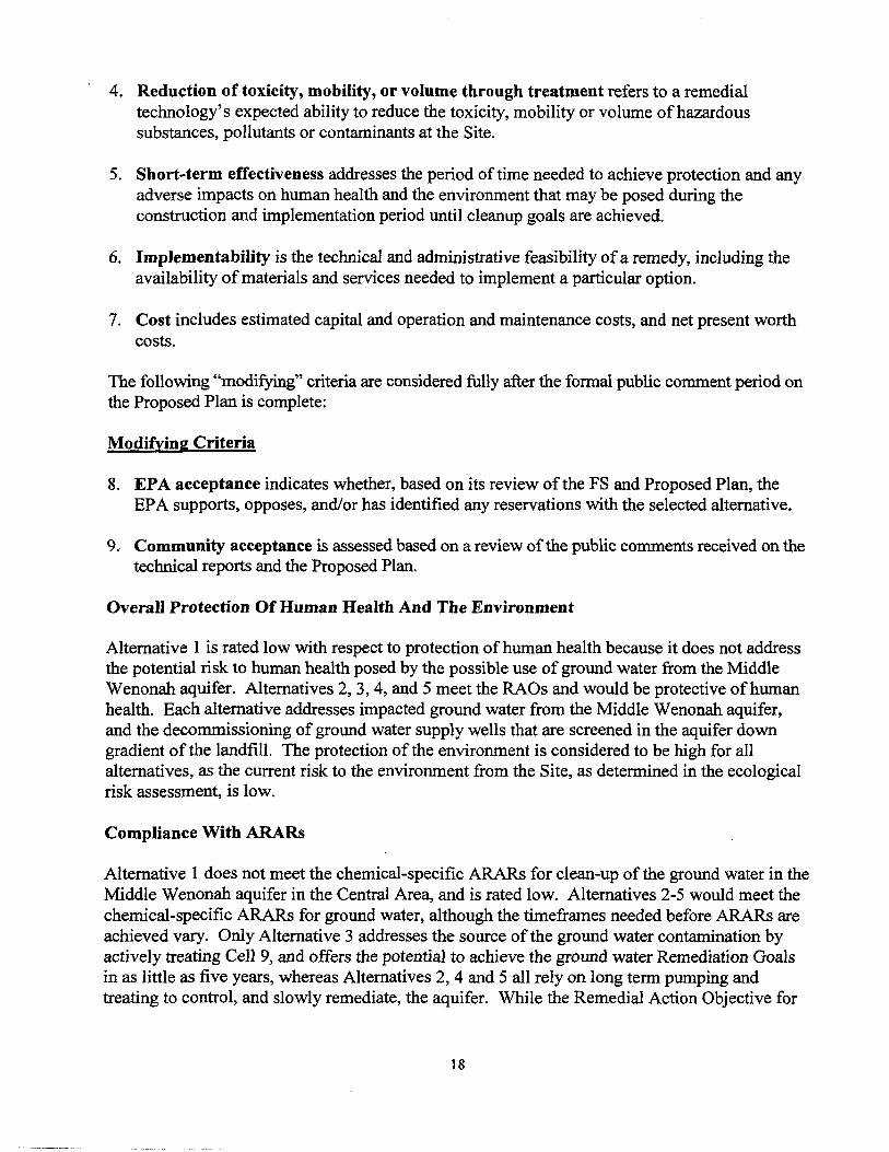
4. Reduction of toxicity, mobility, or volume through treatment refers to a remedialtechnology's expected ability to reduce the toxicity, mobility or volume of hazardoussubstances, pollutants or contaminants at the Site.
5. Short-term effectiveness addresses the period of time needed to achieve protection and anyadverse impacts on human health and the environment that may be posed during theconstruction and implementation period until cleanup goals are achieved.
6. Implementability is the technical and administrative feasibility of a remedy, including theavailability of materials and services needed to implement a particular option.
7. Cost includes estimated capital and operation and maintenance costs, and net present worthcosts.
The following "modifying" criteria are considered fully after the formal public comment period onthe Proposed Plan is complete:
Modifying Criteria
8. EPA acceptance indicates whether, based on its review of the FS and Proposed Plan, theEPA supports, opposes, and/or has identified any reservations with the selected alternative.
9. Community acceptance is assessed based on a review of the public comments received on thetechnical reports and the Proposed Plan.
Overall Protection Of Human Health And The Environment
Alternative 1 is rated low with respect to protection of human health because it does not addressthe potential risk to human health posed by the possible use of ground water from the MiddleWenonah aquifer. Alternatives 2, 3,4, and 5 meet the RAOs and would be protective of humanhealth. Each alternative addresses impacted ground water from the Middle Wenonah aquifer,and the decommissioning of ground water supply wells that are screened in the aquifer downgradient of the landfill. The protection of the environment is considered to be high for allalternatives, as the current risk to the environment from the Site, as determined in the ecologicalrisk assessment, is low.
Compliance With ARARs
Alternative 1 does not meet the chemical-specific ARARs for clean-up of the ground water in theMiddle Wenonah aquifer in the Central Area, and is rated low. Alternatives 2-5 would meet thechemical-specific ARARs for ground water, although the timeframes needed before ARARs areachieved vary. Only Alternative 3 addresses the source of the ground water contamination byactively treating Cell 9, and offers the potential to achieve the ground water Remediation Goalsin as little as five years, whereas Alternatives 2, 4 and 5 all rely on long term pumping andtreating to control, and slowly remediate, the aquifer. While the Remedial Action Objective for
18
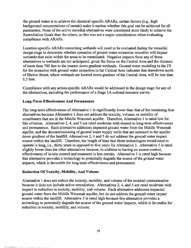
the ground water is to achieve the chemical-specific ARARs, certain factors (e.g., highbackground concentrations of metals) make it unclear whether this goal can be achieved for allparameters. None of the active remedial alternatives were considered more likely to achieve theRemediation Goals than the others, so this was not a major consideration when evaluatingcompliance with ARARs.
Location-specific ARARs concerning wetlands will need to be evaluated during the remedialdesign stage to determine whether operation of ground water extraction remedies will impactwetlands that exist within the areas to be remediated. Negative impacts from any of thesealternatives to wetlands are not anticipated, given the focus on the Central Area and the distanceof more than 700 feet to the nearest down gradient wetlands. Ground water modeling in the FSfor the scenarios with ground water extraction in the Central Area indicates that drawdown northof Shreve Street, where wetlands are located down gradient of the Central Area, will be less than0.5 feet.
Compliance with any action-specific ARARs would be addressed in the design stage for any ofthe alternatives, including the performance of a Stage 1A cultural resource survey.
Long-Term Effectiveness And Permanence
The long-term effectiveness of Alternative 1 is significantly lower than that of the remaining fouralternatives because Alternative 1 does not address the toxicity, volume, or mobility ofconstituents that are in the Middle Wenonah aquifer. Therefore, Alternative 1 is rated low forthis criterion. Alternatives 2, 4, and 5 are rated moderate with respect to long-term effectivenessand permanence. Each alternative addresses impacted ground water from the Middle Wenonahaquifer, and the decommissioning of ground water supply wells that are screened in the aquiferdown gradient of the landfill. Alternatives 2, 4 and 5 do not address the ground water impactsource within the landfill. Therefore, the length of tune that these technologies would need tooperate is long, i.e., thirty years as opposed to five years for Alternative 3. Alternative 5 is ratedslightly lower than the other alternatives because, in addition to having no source control,effectiveness of in-situ control and treatment is less certain. Alternative 3 is rated high becausethis alternative provides a technology to potentially degrade the source of the ground waterimpacts, which is favorable for long-term effectiveness and permanence.
Reduction Of Toxicity, Mobility, And Volume
Alternative 1 does not reduce the toxicity, mobility, and volume of the residual contaminationbecause it does not include active remediation. Alternatives 2,4, and 5 are rated moderate withrespect to reduction in toxicity, mobility, and volume. Each alternative addresses impactedground water from the Middle Wenonah aquifer, but do not address the ground water impactsource within the landfill. Alternative 3 is rated high because this alternative provides atechnology to potentially degrade the source of the ground water impacts, which is favorable forreduction in toxicity, mobility, and volume.
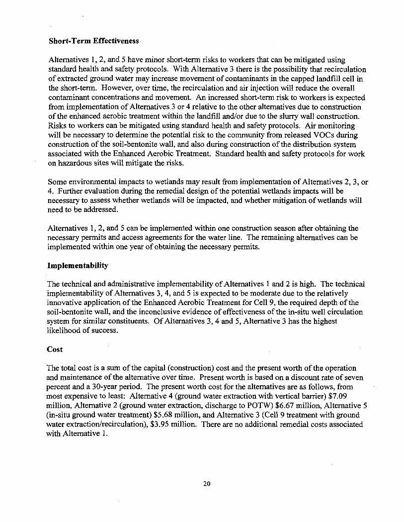
Short-Term Effectiveness
Alternatives 1, 2, and 5 have minor short-term risks to workers that can be mitigated usingstandard health and safety protocols. With Alternative 3 there is the possibility that recirculationof extracted ground water may increase movement of contaminants in the capped landfill cell inthe short-term. However, over time, the recirculation and air injection will reduce the overallcontaminant concentrations and movement. An increased short-term risk to workers is expectedfrom implementation of Alternatives 3 or 4 relative to the other alternatives due to constructionof the enhanced aerobic treatment within the landfill and/or due to the slurry wall construction.Risks to workers can be mitigated using standard health and safety protocols. Air monitoringwill be necessary to determine the potential risk to the community from released VOCs duringconstruction of the soil-bentonite wall, and also during construction of the distribution systemassociated with the Enhanced Aerobic Treatment. Standard health and safety protocols for workon hazardous sites will mitigate the risks.
Some environmental impacts to wetlands may result from implementation of Alternatives 2, 3, or4. Further evaluation during the remedial design of the potential wetlands impacts will benecessary to assess whether wetlands will be impacted, and whether mitigation of wetlands willneed to be addressed.
Alternatives 1, 2, and 5 can be implemented within one construction season after obtaining thenecessary permits and access agreements for the water line. The remaining alternatives can beimplemented within one year of obtaining the necessary permits.
Implementability
The technical and administrative implementability of Alternatives 1 and 2 is high. The technicalimplementability of Alternatives 3, 4, and 5 is expected to be moderate due to the relativelyinnovative application of the Enhanced Aerobic Treatment for Cell 9, the required depth of thesoil-bentonite wall, and the inconclusive evidence of effectiveness of the in-situ well circulationsystem for similar constituents. Of Alternatives 3, 4 and 5, Alternative 3 has the highestlikelihood of success.
Cost
The total cost is a sum of the capital (construction) cost and the present worth of the operationand maintenance of the alternative over time. Present worth is based on a discount rate of sevenpercent and a 30-year period. The present worth cost for the alternatives are as follows, frommost expensive to least: Alternative 4 (ground water extraction with vertical barrier) $7.09million, Alternative 2 (ground water extraction, discharge to POTW) $6.67 million, Alternative 5(in-situ ground water treatment) $5.68 million, and Alternative 3 (Cell 9 treatment with groundwater extraction/recirculation), $3.95 million. There are no additional remedial costs associatedwith Alternative 1.
20
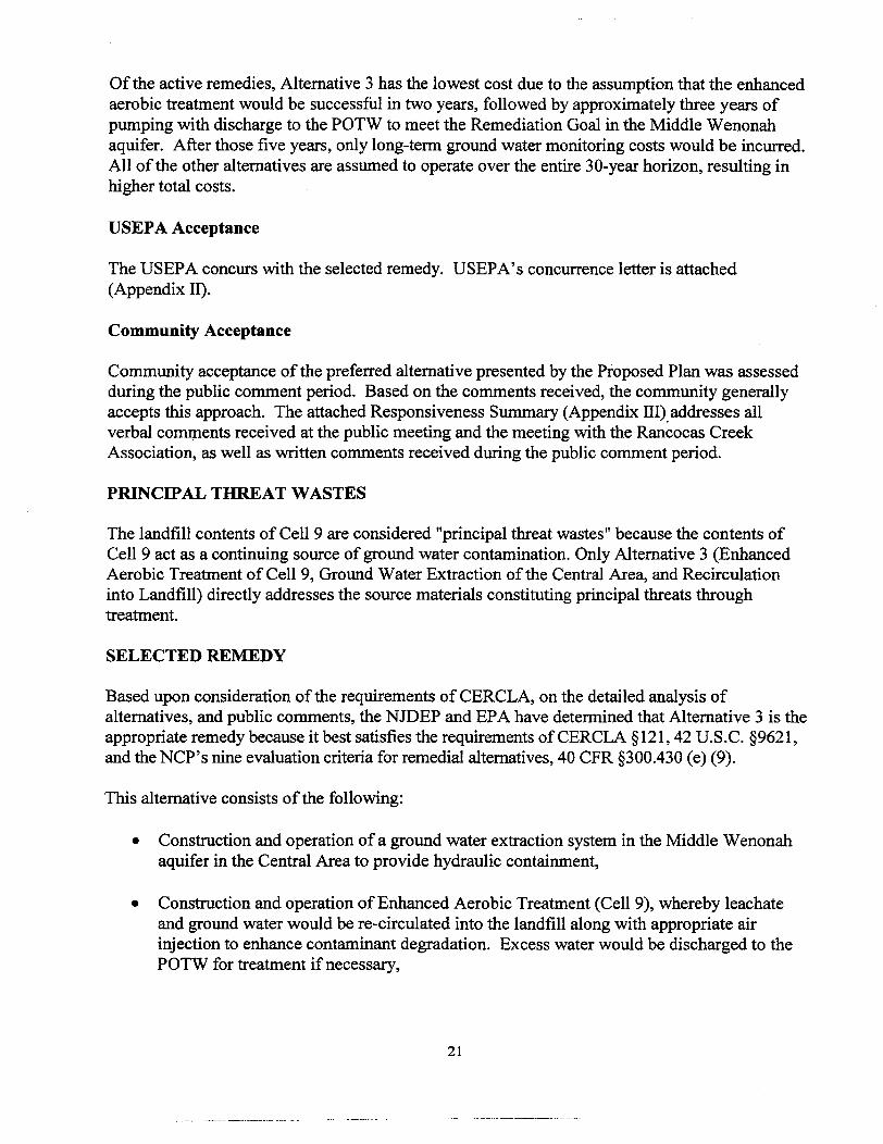
Of the active remedies, Alternative 3 has the lowest cost due to the assumption that the enhancedaerobic treatment would be successful in two years, followed by approximately three years ofpumping with discharge to the POTW to meet the Remediation Goal in the Middle Wenonahaquifer. After those five years, only long-term ground water monitoring costs would be incurred.All of the other alternatives are assumed to operate over the entire 30-year horizon, resulting inhigher total costs.
USEPA Acceptance
The USEPA concurs with the selected remedy. USEPA's concurrence letter is attached(Appendix II).
Community Acceptance
Community acceptance of the preferred alternative presented by the Proposed Plan was assessedduring the public comment period. Based on the comments received, the community generallyaccepts this approach. The attached Responsiveness Summary (Appendix III) addresses allverbal comments received at the public meeting and the meeting with the Rancocas CreekAssociation, as well as written comments received during the public comment period.
PRINCIPAL THREAT WASTES
The landfill contents of Cell 9 are considered "principal threat wastes" because the contents ofCell 9 act as a continuing source of ground water contamination. Only Alternative 3 (EnhancedAerobic Treatment of Cell 9, Ground Water Extraction of the Central Area, and Recirculationinto Landfill) directly addresses the source materials constituting principal threats throughtreatment.
SELECTED REMEDY
Based upon consideration of the requirements of CERCLA, on the detailed analysis ofalternatives, and public comments, the NJDEP and EPA have determined that Alternative 3 is theappropriate remedy because it best satisfies the requirements of CERCLA §121,42 U.S.C. §9621,and the NCP's nine evaluation criteria for remedial alternatives, 40 CFR §300.430 (e) (9).
This alternative consists of the following:
• Construction and operation of a ground water extraction system in the Middle Wenonahaquifer in the Central Area to provide hydraulic containment,
• Construction and operation of Enhanced Aerobic Treatment (Cell 9), whereby leachateand ground water would be re-circulated into the landfill along with appropriate airinjection to enhance contaminant degradation. Excess water would be discharged to thePOTW for treatment if necessary,
21
• Long-term monitoring for ground water exceeding the remedation goals, including in theFlank Areas not targeted for active extraction and treatment,
• Continued maintenance of the existing final cover system on the landfill,
• Continued landfill leachate and gas monitoring, collection., and disposal,
• Decommissioning of residential water-supply wells down gradient of the landfill,
• Continued maintenance of the Site security.
Regarding residential properties down gradient of the landfill, Burlington County is in theprocess of acquiring properties along Rabbit Run and Hand Lane. The County would like toacquire these properties for various reasons, including:
• The dwellings are served by on-site septic systems located in the floodplain or adjacent toRancocas Creek. These septic systems may be responsible for the exceedance of the waterquality standard for fecal coliform in the North Branch of the Rancocas Creek.
• The dwellings are in the floodplain and therefore are subject to frequent flooding.
• These properties lie adjacent to Smithville Park, and the County would like to create agreenway along the North Branch of the Rancocas Creek that would link Smithville Park toother County-owned properties along the Creek and Rancocas State Park.
If the County does not provide NJDEP with written documentation from the Board of ChosenFreeholders of Burlington County within 6 months that the properties will be acquired by March2006, or otherwise satisfactorily demonstrate to NJDEP that it will acquire these properties in areasonable timeframe, the following remedy will also be implemented:
• Water line extension to Hand Lane and along the western portion of Rabbit Run, downgradient of the landfill.
If the County does provide written documentation to NJDEP that it will acquire these propertiesin a reasonable timeframe, then the water line extension along the western portion of Rabbit Run,down gradient of the landfill, will not be installed.
Currently the residents on Hand Lane and Rabbit Run are provided bottled water by the L&DCompany. Those residents will continue to receive bottled water until their property either isacquired by the County or the water line is installed.
Implementation of the selected remedy would be phased, with a first group of three to fourground water extraction wells installed near the landfill that could be augmented in the future bytwo additional extraction wells in the Middle Wenonah aquifer (near existing wells LDM-206and LDM-210) if sufficient concentration reductions between the landfill and the creek are not
22
observed. These down gradient wells may actually draw contaminants beyond the containmentwells at the landfill, and delaying their implementation by approximately one to two years wouldallow for an opportunity to monitor the effectiveness of the remedy without these wells. Ifmonitoring during this one to two year time frame indicates that the initial pumping program iseffective in addressing the area between the landfill and the creek, or indicates substantialconcentration reductions such that adequate remediation of that area is considered likely withinthe subsequent three years, then the two off-site wells would not be implemented.
Based upon experience at other landfills, Enhanced Aerobic Treatment appears likely to besuccessful at reducing the source of contamination, and in shortening the time required foraquifer restoration; however, the process may lose its effectiveness after a limited period of time.Under the selected remedy, the Enhanced Aerobic Treatment would continue as long as leachatecontaminant concentrations in Cell 9 remain higher than leachate concentrations in the otherlandfill cells, and indicator parameters for biological activity, such as temperature and carbondioxide levels, indicate that biological activity remains enhanced relative to baseline valuesmeasured before the treatment begins. NJDEP may also consider the relative cost andeffectiveness of this treatment technology when compared to the cost of off-site treatment at aPOTW. If conditions indicate that this technology is no longer effective based upon thesecriteria, the landfill leachate and extracted ground water would then be sent to the POTW forappropriate treatment and disposal (similar to Alternative 2). In the FS, a timeframe of two yearsfor active recirculation followed by three years of continued pumping after recirculation (in theCentral Area) was assumed for the purpose of estimating costs.
Pumping for ground water containment would continue after the Enhanced Aerobic Treatmentuntil ground water concentrations monitored in the Central Area achieve the remediation goals,or alternatively when it is demonstrated that ground water concentrations in the Central Area aresimilar to those observed in the Flank Areas. The goal of the selected remedy is to preventexposure of the public to contaminated ground water and to restore the contaminated groundwater to ground water quality standards within a reasonable timeframe. However, due to thehigh background concentration of metals, it is unclear when this goal of aquifer restoration wouldbe achieved, if ever. In addition, the selected remedy does not include active remediation in theFlank Areas of the plume, and it is unclear how long it would take for this relatively diffuseplume to recover without active treatment. Therefore, NJDEP would plan a phased approach toimplementing this remedy, whereby a ground water remedy would be implemented and, after acertain period of operation and monitoring, certain chemical-specific ARARs may potentially bewaived for Technical Impracticability (TI), through an Explanation of Significant Differences. ATI waiver may be invoked under one or more of the following conditions, or "triggers": (1) ifremaining risks are associated with background conditions or (2) if further improvements toground water quality appear unachievable.
Based on the information available at this time, NJDEP and EPA believe the selected remedywould be protective of human health and the environment, would comply with ARARs, would becost-effective, and would utilize permanent solutions and alternative treatment technologies tothe maximum extent practicable. The selected alternative also incorporates the statutory
23
preference for the selection of a remedy that involves treatment, as Enhanced Aerobic Treatmentwould degrade contaminants that are the source of the ground water contamination.
STATUTORY DETERMINATIONS
As previously noted, CERCLA §121(b)(l), 42 U.S.C. §9621(b)(l), mandates that a remedial actionmust be protective of human health and the environment, cost effective, and utilize permanentsolutions and alternative treatment technologies or resource recovery technologies to the maximumextent practicable. Section 121 (b)(l) also establishes a preference for remedial actions that employtreatment to permanently and significantly reduce the volume, toxicity, or mobility of hazardoussubstances, pollutants, or contaminants at a Site. CERCLA §121(d), 42 U.S.C. §9621 (d) furtherspecifies that a remedial action must attain a degree of cleanup that satisfies ARARs under federaland state laws, unless a waiver can be justified pursuant to CERCLA §121(d)(4), 42 U.S.C.§9621(d)(4). For the reasons discussed below, NJDEP has determined that the selected remedy atthe Landfill & Development Site meets the requirements of CERCLA §121,42 U.S.C. §9621.
Protection of Human Health and the Environment
Of the five alternatives evaluated, the selected remedy provides the greatest protection of humanhealth and the environment. Enhanced aerobic treatment will degrade the contents of Cell 9 of thelandfill, which is the source of the ground water impacts. The other alternatives would not degradethe contents of the landfill, therefore this alternative is rated higher. Human health will be protectedthrough the installation of the water line down gradient of the landfill (if the County does notacquire the properties), decommissioning of residential wells down gradient of the landfill andimplementation of a Classification Exception Area. Ground water will eventually be restored toState Ground Water Quality Standards or Federal MCLs. Maintenance of the landfill will continueas specified in the approved landfill closure plan, including maintenance of the cap.
Compliance with Applicable or Relevant and Appropriate Requirements (ARARs)
The National Contingency Plan, Section 300.430(f)(ii)(B) requires that the selected remedy attainFederal and State ARARs. The remedy will comply with the following action-, chemical- andlocation-specific ARARs identified for the Site and will be demonstrated through monitoring, asappropriate.
Action-Specific ARARs:
« N.J.A.C. 7:26E - Technical Requirements for Site Remediation
• P.L. 1997 c. 39 - Brownfield and Contaminated Site Remediation Act
• 40 CFR 6301 (c) - National Historic Preservation Act
24
Chemical-Specific ARARs (the chemical-specific ARARs for ground water are listed in Tables 6, 7and 8).
• 40 CFR Part 141 - Federal Safe Drinking Water Act Maximum Contaminant Levels (MCLs)
• N.J.A.C. 7:9 et. seq. - Ground Water Quality Standards
e Air standards set forth in 40 CFR 50 and N.J.A.C. 7:27 et. seq.
Location-Specific ARARs:
• NJ.A.C. 7:7A - New Jersey Freshwater Protection Act
Cost Effectiveness
Each of the alternatives has undergone a detailed cost analysis. In that analysis, capital costs andannual costs have been estimated and used to develop the total cost. The cost effectiveness of analternative is determined by weighing the cost against the alternative's ability to achieve ARARsand remedial action objectives. The selected remedy for the Site, Alternative 3, will achieve thegoals of the response actions and is cost-effective because it will provide the best overalleffectiveness in proportion to its costs.
Utilization of Permanent Solutions and Alternative Treatment Technologies to the MaximumExtent Practicable
The selected remedy meets the statutory requirement to utilize permanent solutions and treatmenttechnologies to the maximum extent practicable.
Preference for Treatment as a Principal Element
The selected remedy satisfies the statutory preference for remedies that employ treatment as aprincipal element.
Five-Year Review Requirements
Because this remedy will result in hazardous substances, pollutants, or contaminants remaining on-site above levels that allow for unlimited use and unrestricted exposure, a statutory review will beconducted at five-year intervals starting after initiation of the remedial action to ensure that theremedy is, or will be, protective of human health and the environment.
DOCUMENTATION OF SIGNIFICANT CHANGES
The Proposed Plan for the Landfill and Development site was released for public comment hiMay 2004. The Proposed Plan identified Alternative 3, Enhanced Aerobic Treatment of Cell 9,
25
Ground Water Extraction of the Central Area, and Recirculation into Landfill, as the PreferredAlternative for the site. NJDEP reviewed all written and verbal comments submitted during thepublic comment period. It was determined that no significant changes to the remedy, asoriginally identified in the Proposed Plan, were necessary or appropriate.
26
2402003011 A.DWG
SEVEN GATES DAM-
IDS-206
[UN-206]
LEGENDSWALES (USUALLY DRY)
FENCE LINESLOPE ASSOCIATED WITHTHE LANDFILL
MLCMS AQUIFER
MIDDLE WENONAH AQUIFER
ENGLISHTOWN AQUIFER
LEACHATE COLLECTIONMANHOLE
-*•
e
LANDFILL CELLS
EXTENT OF LEACHATECOLLECTION SYSTEM ANDINTERMEDIATE LINER
MONITORING WELL
PIEZOMETER
-N-
PLANNEDWATERLINEEXTENSION
:l NORTHWESTmsra
MOUNT HOLLY SECTION
1. WELLS 102M AND LDE-1 WERE FOUND TO HAVEBROKEN CASINGS.
2. THE FOLLOWING WELLS NO LONGER EXIST: 107MAND LDE-4.
3. THE FOLLOWING WELLS COULD NOT BE LOCATED:PZ-26S (MAY NO LONGER EXIST), PZ-26M (MAYNO LONGER EXIST), AND LDM-211 (BURIED IN ASPHALT).
EASTAMPTON SECTION
us-iBl"--':;-..- - - '-•••••
1000
SCALE IN FEET
2000
Figure 1. Landfill Cells, Extent of Leachate Collection System and Intermediate Liner, and Gas Extraction Wells. rans,inc.
2402003012A.OWG
LEGEND
SWALES (USUALLY DRY)
FENCE LINE
moatst, SLOPE ASSOCIATED WITH
EXTENT OF LEACHATECOLLECTION SYSTEM ANDINTERMEDIATE LINER
MONITORING WELL
PIEZOMETER
CREEK LEVEL LOCATIONS
THE LANDFILL
us~3l» MLCMS AQUIFER
(IMC-206] MIDDLE WENONAH AQUIFER
ENGLISHTOWN AQUIFER
\ MOUNT HOLLY SECTION
38-
40-
EASTAMPTON SECTION
1. WELLS 102M AND LDE-1 WERE FOUND TO HAVEBROKEN CASINGS.
2. THE FOLLOWING WELLS NO LONGER EXIST: 107MAND LDE-4. SCALE IN FEET
3. THE FOLLOWING WELLS COULD NOT BE LOCATED:PZ-26S (MAY NO LONGER EXIST). PZ-26M (MAYNO LONGER EXIST), AND LDM-211 (BURIED IN ASPHALT).
Figure 2. Potentiometric Surface Map, MLCMS Aquifer, August 12,1999.
2402003013A.DWG
LEGEND
SWALES (USUALLY DRY)
FENCE LINE
.«»-« SLOPE ASSOCIATED WITHTHE LANDFILL
UB-iffi MLCMS AQUIFER
[1M-206] MIDDLE WENONAH AQUIFER
ENGLISHTOWN AQUIFER
EXTENT OF LEACHATECOLLECTION SYSTEM ANDINTERMEDIATE LINER
MONITORING WELL
o PIEZOMETER
* CREEK LEVEL LOCATIONS
> • NORTHWEST.^•iSEOIMCNTATKM
3'f0"0
\\ MOUNT HOLLY SECTION
EASTAMPTON SECTION
1. WELLS 102M AND LDE-1 WERE FOUND TO HAVEBROKEN CASINGS.
2. THE FOLLOWING WELLS NO LONGER EXIST: 107MAND LDE-4. SCALE IN FFFTTHE FOLLOWING WELLS COULD NOT BE LOCATED:P2-26S (MAY NO LONGER EXIST), PZ-26M (MAYNO LONGER EXIST). AND LDM-211 (BURIED IN ASPHALT).
Figure 3. Potentiometric Surface Map, Middle Wenonah Aquifer, August 12, 1999
2402003014A. DWG
SEVEN GATES DAM
->-->->- SWALES (USUALLY DRY)FENCE LINE
MVBVOW SLOPE ASSOCIATED WITHTHE LANDFILL
u«-«« MLCMS AQUIFER
iiai-206) MIDDLE WENONAH AQUIFER
|ut-2«| ENGLISHTOWN AQUIFER
EXTENT OF LEACHATECOLLECTION SYSTEM ANDINTERMEDIATE LINER
MONITORING WELL
PIEZOMETER -N-
NORTHEASTSEfflWENTA
PONO OUIFALL|p
I MOUNT HOLLY SECTION
EASTAMPTON SECTION
28—
IlK-ftBl28.23
NOTES:
1. WELLS 102M AND LDE-1 WERE FOUND TO HAVEBROKEN CASINGS.
2. THE FOLLOWING WELLS NO LONGER EXIST: 107MAND LDE-4.
3. THE FOLLOWING WELLS COULD NOT BE LOCATED:PZ-26S (MAY NO LONGER EXIST), PZ-26M (MAYNO LONGER EXIST), AND LDM-211 (BURIED IN ASPHALT).
4. * WELL LD-9 WAS FLOWING AT GROUND SURFACE, 21.08FT MSL IS TOP OF CASING ELEVATION.
Figure 4. Potentiometric Surface Map, Englishtown Aquifer, August 12, 1999.
0 1000
=i=SCALE IN FEET
2000
ransin,
2402003015A. DWG
LEGEND
SWALES (USUALLY DRY)
- FENCE LINEsarrms SLOPE ASSOCIATED WITH
THE LANDFILL
-$-' MONITORING WELL NOT SAMPLE
O NO VOCs EXCEED GW QUALITY CRITERIA
Q ONE OR MORE VOCs EXCEED GW QUALITY CRITERIA
-N-
UK-20ff^ y^"-^-,-.- '̂ "^ v ''"^:'y~--- ff
LDS-2KP ^-f\/" *&"*'rf£~'' ~'"^^J\i//"
,'•' '"\ .•'^'—\* j^fc. X.-/'
^%
2I5(B)
ABBREVIATION
BEN
CB
PARAMETER
Benzene
Chlorobenzene
NJGWOS
("9/L)
1
4
MCL(ug/L)
5
100
NOTE: WELL 2S NOT SAMPLED DUE TO INSUFFICIENT WATER LEVEL.
Figure 5. VOCs Exceeding Groundwater Criteria, Rl Sitewide Sampling (1999), MLCMS Aquifer.
1000
SCALE IN FEET
2000
2402003022A.DWG
LEGEND
— SWALES (USUALLY DRY)
FENCE LINE
SLOPE ASSOCIATED WITHTHE LANDFILL
-$- MONITORING WELL NOT SAMPLED
O NO VOCs EXCEED GW QUALITY CRITERIA
O ONE OR MORE VOCs EXCEED GW QUALITY CRITERIA
® CENTRAL AREA, FRINGE ZONE
• CENTRAL AREA, CORE ZONE
-N-
1.2-DCAI760JUEK: 40000MIBK: 28000ACE: 39000BEN: MODCIS-t.2: 770MC: 760DTOL: 8200VC: 2BJ
\\ If /••CENTRAL I=J I
"'
ABBREVIATION
1,2-DCA
1,2-DCP
MEK
MIBK
ACE
BEN
CB
PARAMETER
1 ,2-Dichlgrathoni
1 ,2-Dlchloroprapan*
2— Butanon*
4-M«thyl-2-P«nlonon.
Ac«lon«
B«nz«n*Chlorobenz.n.
NJGWOS(UB/U
21
300
400
700
1
4
MCL(ug/l)
5
5
-
-
-
5
100
ABBREVIATION
CIS-12
MC
PCE
TOL
TCE
VC
PARAMETER
CIs- 1 ,2-Dichloro.th.n.
U«lhyl«n« Chloridd
TvtrachlorovthAM
Tolu«n«
Trichloroithim
Vinyl Chloridi
NJOWOS(ug/L)
10
2
1
100015
MCL(ug/L)
70
5
S
1000
5
2
1000
SCALE IN FEET
2000
NOTE: WELLS 107M AND LDM-211 NO LONGER EXIST. WELL 102M HAD BROKEN CASING.
Figure 6. VOCs Exceeding Groundwater Criteria, Rl Sitewide Sampling (1999), Middle Wenonah Aquifer. ransmc
24C200M23A.DWG
VOCs Exceeding Groundwater Criteria Sitewide SamplingMiddle Wenonah Aquifer and Proposed Remediation System
22U(ug/L)
1.2-OCA: 760JMEK: «OODMBffc 2800DACE: 3900DSEN: 14QD
CtS-1.2: 77DMC: 76DDTOL: 8200VC 28J
U*W10(uefr)130J
1700D160003800D28DJ42DJ91 DJS50O27DJ
LDM-206{uffU
1800J6400zaoo3600B4J&J2100
1700
100U
PLANNEDWATERLINEEXTENSION
CORE Op"CENTRAL/ AREA"
NOTE: WELLS 107M AND LDM-211 NO LONGER BUST. WILL I02U HAD BROKEN CASINO,
0 700 1400L-l
SCALE IN FEET
Figure 7. Selected Alternative.
LEGEND
PUMPING WELL
AIR/WATER REDISTRIBUTION POINT
' PIPING TO POTW FORCEMAIN
PIPE TO REDISTRIBUTION POINTS
SWALES (USUALLY DRY)
FENCE LINE
— SLOPE ASSOCIATED WITH THE LANDFILL
MONITORING WELL NOT SAMPLED
NO VOCs EXCEED GW QUALITY CRITERIA
ONE OR MORE VOCs EXCEED GW QUALITY CRITERIA
CENTRAL AREA, FRINGE ZONE
CENTRAL AREA, CORE ZONE
TABLE 1
Landfill and Development Site
Summary of Chemicals of Concern andMedium-Specific Exposure Point Concentrations
Scenario Timeframe: Current/FutureMedium: Groundwater in Middle Wenonah , Centra! (core)Pvnnenra Mo/lliinv firnnn/iu/atar
ExposurePoint
Tap Water
Chemical of Concern
Arsenic
1,2-Dfchloroethane
2-Butanone
4-Methyl-2-Pentanone
Acetone
Benzene
Methylene Chloride
Toluene
Vinyl Chloride
ConcentrationDetected
Win
5.2e+00
6.06-01
4.0e+00
6.00-01
2.0e+00
3.0e+bo
S.Oe-01
S.Oe-01
2.0e+00
Max
2.0e+01
1.8e+03
6.4e+Q3
2.8e+03
3.9e+03
1.4e+02
2.1e+03
1.7e+03
2.8e+01
Concen-trationUnits
ug/L
ug/L
ug/L
ug/L
ug/L
ug/L
ug/L
ug/L
ug/L
Frequencyof Detection
6/7
6/7
5/7
6/7
4/7
5/7
6/7
6/7
5/7
ExposurePoint
Concen-tration
2.0e+01
1.8e+03
3.6e+03
2.8e+03
3.9e+03
1.4e+02
2.1e+03
1.1e+03
2.2e+01
ExposurePoint
Concen-trationUnits
ug/L
ug/L
ug/L
ug/L
ug/L
ug/L
ug/L
ug/L
ug/L
StatisticalMeasure
MAX
MAX
UCL-N
MAX
MAX
MAX
MAX
UCL-N
UCL-N
Keyug/L: micrograms per liter, part per billionUCL - N: 95% Upper Confidence Limit of Log Normally Distributed DataMAX: Maximum Concentration
Summary of Chemicals of Concern and Medium-Specific Exposure Point Concentrations
The tables present the chemicals of concern (COCs) and exposure point concentration for each of the COCs detected in the central core of the MiddleWenonah aquifer. In addition, this table includes the range of concentrations detected for each COC, as well as the frequency of detection (i.e., trienumber of times the chemical was detected in the samples collected at the site), the exposure point concentration (EPC), and how the EPC was derived.A complete list of all chemicals that were quantitatively evaluated in the central core of the Middle Wenonah Aquife, as well as all other media that weresampled in the remedial Investigation, can be found in the Human Health Risk Assessment
Page 1 of 1
TABLE 2
Landfill and Development Site
Cancer Toxicity Data Summary
Pathway: Ingestion, Dermal
Chemical of Concern
Arsenic
1,2-Dlchloroethane
2-Butanone
4-Methyl-2-pentanone
Acetone
Benzene
Methylene Chloride
Toluene
Vinyl chloride
OralCancerSlopeFactor
1.5e«00
9.1e-02
N/A
N/A
N/A
5.56-02
7.56-03
N/A
ISe+OO
Units
1/(mg/kg-day)
1/(mg/kg-day)
' N/A
N/A
N/A
1/(mg/kg-day)
1/(mg/kg-day)
N/A
1/(mg/kg-day)
AdjustedCancer Slope
Factor(for Dermal)
1.5e«00
9.16-02
N/A
N/A
' N/A
5.5e-02
7.56-03
N/A
'1.56+00
Slope FactorUnits
1/(mg/kg-day)
1/(mg/kg-day)
N/A
N/A
N/A
1/(mg/kg-day)
1/(mg/kg-day)
N/A
1/(mg/kg-day)
Weight ofEvidence/Cancer
GuidelineDescription
A
B2
N/A
N/A
N/A
A
82
N/A
A
Source
IRIS
IRIS
N/A
N/A
N/A
IRIS
IRIS
N/A
IRIS
Date
11/30/00
11/30/00
N/A
N/A
N/A
11/30/00
11/30/00
N/A
11/30/00
Pathway: Inhalation
Chemical of Concern
Arsenic
1,2-Dichloroethane
2-Butanone
4-Methyl-2-pentanone
Acetone
Benzene
Methylene Chloride
Toluene
Vinyl chloride
Unit Risk
4.36-03
2.66-05
N/A
N/A
N/A
7.86-06
N/A
N/A
4.46-06
Units
1/(ug/m3)
1/(ug/m3)
N/A
N/A
N/A
1/(ug/m3)
1/(ug/m3)
N/A '
1/(ug/m3)
InhalationCancer Slope
Factor
1.56+01
9.1e-02
N/A
N/A
N/A
2.76-02
1.7e-03
N/A
1.58-02
Units
1/(mg/kg-day)
1/(mg/kg-day)
N/A
N/A
N/A
1/(mg/kg-day)
1/(mg/kg-day)
N/A
1/(mg/kg-day)
Weight ofEvidence/Cancer
GuidelineDescription
A
B2
N/A
N/A
N/A
A
B2
N/A
A
Source
IRIS
IRIS
N/A
N/A
N/A
IRIS
IRIS
N/A
IRIS
Date
11/30/00
11/30/00
N/A
N/A
N/A
11/30/00
11/30/00
N/A
11/30/00
Key
N/A: No information available
IRIS: Integrated Risk Information System, U.S. EPA
EPA Group:
A - Human carcinogenB1 - Probable Human Carcinogen-Indicates that limited human data are available62 - Probable Human Carcinogen-Indicates sufficient evidence in
animals associated with the site and inadequate or no
Page 1 of 2
evidence in humansC - Possible human carcinogenD - Not classifiable as a human carcinogenE - Evidence of noncarcinogenicity
Summary of Toxicity Assessment
This table provides carcinogenic risk information which is relevant to the contaminants of concern. Toxicity data are provided for both the oral and inhalationroutes of exposure.
Page 2 of 2
TABLE 3
Landfill and Development Site
Non-Cancer Toxicity Data Summary
Pathway: Ingestion/Dermal
Chemical of Concern
Arsenic
1,2-Dichloroethane
2-Butanone
4-Methyl-2-pentanone
Acetone
Benzene
Methylene Chloride
Toluene
Vinyl chloride
Chronic/Subchronlc
Chronic
Chronic
Chronic
Chronic
Chronic
Chronic
Chronic
Chronic
Chronic
Oral RfDValue
3.0e-04
3.0e-02
6.06-01
8.0e-02
1.0*01
3.0e-03
6,0e-02
2.0e-01
3.0e-03
OralRfOUnits
mg/kg-day
mg/kg-day
mg/kg-day
mg/kg-day
mg/kg-day
mg/kg-day
mg/kg-day
mg/kg-day
mg/kg-day
DermalRID
3.06-04
3.06-02
6.06-01
S.Oe-02
I.Oe-01
3.0e-03
6.0e-02
2.06-01
3.0*03
Dermal RfDunltt
mg/kg-day
mg/kg-day
mg/kg-day
mg/kg-day
mg/kg-day
mg/kg-day
mg/kg-day
mg/kg-day
mg/kg-day
Primary Target Organ
Skin, vascular
Liver
Fetal Development
Liver
Liver, Kidney
Blood
Liver
Liver, Kidney
Liver
CombinedUncertainty(Modifying
Factors
3
1000
3000
N/A
1000
3000
100
1000
30
Sourceiof RfD:TargetOrgan
IRIS
NCEA
IRIS
HEAST
IRIS
NCEA
IRIS
IRIS
IRIS
DateeofRfD:
11/30/00
04/23/01
11/30/00
1997
11/30/00
05/04/01
11/30/00
11/30/00
11/30/00
Pathway: Inhalation
Chemical of Concern
Arsenic
1 ,2-Dichloroethane
2-Butanone
4-Methyl-2-pentanone
Acetone
Benzene
Methylene Chloride
Toluene
Vinyl chloride
Chronic/Subchronlc
N/A
Chronic
Chronic
Chronic
N/A
Chronic
Chronic
Chronic
Chronic
InhalationRfC Value
N/A
4.9e-03
1.0e+00
3e+00
N/A
1.76-03
3.06+00
4.0e-01
1.06-01
InhalationRIC Unite
N/A
mg/m3
mg/m3
mg/m3
N/A
mg/m3
mg/m3
mg/m3
mg/m3
InhalationRfD
N/A
1.46-03
2.96-01
8.6e-01
N/A
4.96-04
8.6e-01
1.16-01
2.96-02
InhalationRfD units
N/A
mg/kg- day
mg/kg- day
mg/kg-day
N/A
mg/kg- day
mg/kg- day
mg/kg-day
mg/kg- day
Primary Target Organ
N/A
Liver
Fetal Development
Fetal Development
N/A
N/A
Liver
CNS
Uver
CombinedUncertaintymodifying
Faetora
N/A
3000
3000
300
N/A
N/A
100
300
30
Source*of
RfCfRfD:TargetOrgan
N/A
NCEA
IRIS
IRIS
N/A
NCEA
IRIS
IRIS
IRIS
Dates:
N/A
04/23/01
04/30/00
0400/00
N/A
05/04/01
11/30/00
11/30/00
11/30/00
KeyN/A: No information availableCMS: Central Nervous System EffectsIRIS: Integrated Risk Information System, U.S. EPAHEAST: Health Effects Assessment Summary Tables, U.S. EPANCEA: National Center for Environmental Assessment, U.S. EPA
Summary of Toxicity Assessment
This table provides non-carcinogenic risk information which is relevant to the contaminants of concern. When available, the chronic toxicity data have been used to develop oralreierence ooses \
Page 1 of 2
Page 2 of 2
TABLE 4
Landfill and Development Site
Risk Characterization Summary • Carcinogens Exceeding a Cancer Risk of 1E-4 - Reasonable Maximum Exposure (RME)
Scenario Timeframe: Current/FutureReceptor Population: Residential
flptor Aflp*Medium Exposure
MediumExposure Point Chemical of Concern Carcinogenic Risk
Ingestion Inhalation Dermal Exposure Routes Total
Groundwater Groundwater Middle WenonahAquifer - Central Area -Tap Water
Arsenic
1,2-Dichloroethane
2-Butanone
4-Methyl-2-pentanone
Acetone
Benzene
Methylene Chloride
Toluene
Vinyl Chloride
4.6&04
2.5e-03 1.26-02
8.2e-07
1.96-05
4.6&04
1.5e-02
1.2*04
2.46-04
4.9&04
2.9e-04
2.66-04
2.5*05
3.16-06
1.5e-06
5.0e-06
4.16-04
5.00-04
5.26-04
Groundwater (Middle Wenonah Aquifer- Central Area) Risk: 1.76-02
Key
- : Route of exposure is not applicable to this medium.
Summary of Risk Characterization • Carcinogens
The table presents hsk estimates for the significant routes of exposure. These risk estimates are based on a reasonable maximum exposure and were developed by taking into accouvarious conservative assumptions about the frequency and duration of the receptors exposure to groundwater, as well as the toxicity of the COCs.
Page 1 of 1
TABLE 5
Landfill and Development Site
Risk Characterization Summary • Non-Carcinogens Exceeding a Hazard Index of 1 • Reasonable Maximum Exposure (RME)
Scenario Timeframe: Current/FutureReceptor Population: GroundwaterReceptor Age: Adult/Child
Medium
Groundwater
ExposureMedium
Groundwater
ExposurePoint
MiddleWenonahAquifer,CentralAreaTap Water
Chemical of Concern
Arsenic
1,2-Dichloroethane
2-Butanone
4-Methyl-2-pentanone
Acetone
Benzene
Methylene Chloride
Toluene
Vinyl Chloride
Primary TargetOrgan
Skin, vascular
Liver
Fetal Develop.
Liver
Liver, Kidney
Blood
Liver
Liver, Kidney
Liver
Non-Carcinogenic Hazard Quotient
Ingestionlnha
2.46400
2.16400
2.18-01
1.26400
1.46400
1.6e-*00
1.26400
2.0e-01
-
ation
2.3e-K)2
2.26400
2.56401
-
5.0e-K)1
4.3e-01
1. BetOO
-
Dermal
4.2e-03
1.6e-02
3.66-04
1.8e-03
2.06-03
4.46-02
7.96-03
1.1602
-
Total Middle Wenonah Hazard Index Total/Receptor Hazard Index =
Liver Hazard Index =
Blood Hazard Index =
Skin Hazard Index =
Vascular Hazard Index =
Fetus Hazard Index =
Exposure RoutesTotal
2.46400
2.3e-K)2
2.4e-K)0
2.66401
1.46400
5.26401
1.76400
2.06400
-
3.26402
2.66402
5.26401
2.46400
2.46400
2.46400
Key
• Poiito nf avnnQHro ic tint annlir-ahlo fr> fhic moH'nimipplicabSummary of Risk Characterization - Noncarcinogens
The table presents noncancer (hazard) risk estimates for the significant routes of exposure. These noncancer (hazard) risk estimates are based on a reasonable maximum exposureand were developed by taking into account various conservative assumptions about the frequency and duration of the receptors exposure to groundwater, as well as the toxicity of thiCOCs.
Page 1 of 1
Table 6Ground water Criteria for VOCs
Parameter
1,1,1-Trichloroethane1 ,1 ,2,2-Tetrachloroethane1,1 ,2-Trichloroethane1 , 1 -Dichloroethane1,1-Dichloroethene1 ,2-Dibromo-3-chloropropane1 ,2-Dibromoethane1 ,2-Dichlorobenzene1,2-Dichloroethane1 ,2-Dichloropropane1 ,3-Dichlorobenzene1 ,4-Dichlorobenzene2-Butanone2-Hexanone4-Methyl-2-pentanoneAcetoneBenzeneBromochloromethaneBromodichloromethaneBromoformBromomethaneCarbon disulfideCarbon tetrachlorideChlorobenzeneChloroethaneChloroformChloromethanecis-1 ,2-Dichloroethenecis-1 ,3-DichloropropeneDibromochloromethaneEthylbenzeneMethylene chlorideStyreneTetrachloroetheneToluenetrans-1 ,2-Dichloroethenetrans-1 ,3-DichloropropeneTrichloroetheneVinyl chlorideXylene (total)
NJ GWQS (ug/l)
3023
702
NA0.05600
21
60075
300-
400700
1-14
10-24-6
3010
NA10
7002
1001
1000100NA
15
40
Federal MCL(ug/l)
200-5-7
0.20.05600
55-
75----5
10 (1)100 (2)100 (2)
10 (1)-5
100-
100 (2)3 (1)
7010 (3)
100 (2)700
5100
51000100
10 (3)52
10000
Data EvaluationCriterion (ug/l)
3023
702
0.20.05600
21
60075
300-
400700
11014
10-24-63
101010
7002
1001
10001001012
40
Notes:- NJ GWQS - New Jersey Groundwater Quality Standards (N.J.A.C. 7:9-6) listed value
represents higher of the practical quantitation level and groundwater quality criterion.- Federal MCL - Maximum contaminant levels as set forth in 40 CFR 141 and 143).- Data Evaluation Criterion represents the more stringent of the state and Federal standards.(1) Represents the Lifetime Health Advisory.(2) Represents the MCL for total trihalomethanes.(3) Represents the Drinking Water Equivalent Level.
tables.xls:gw vocs
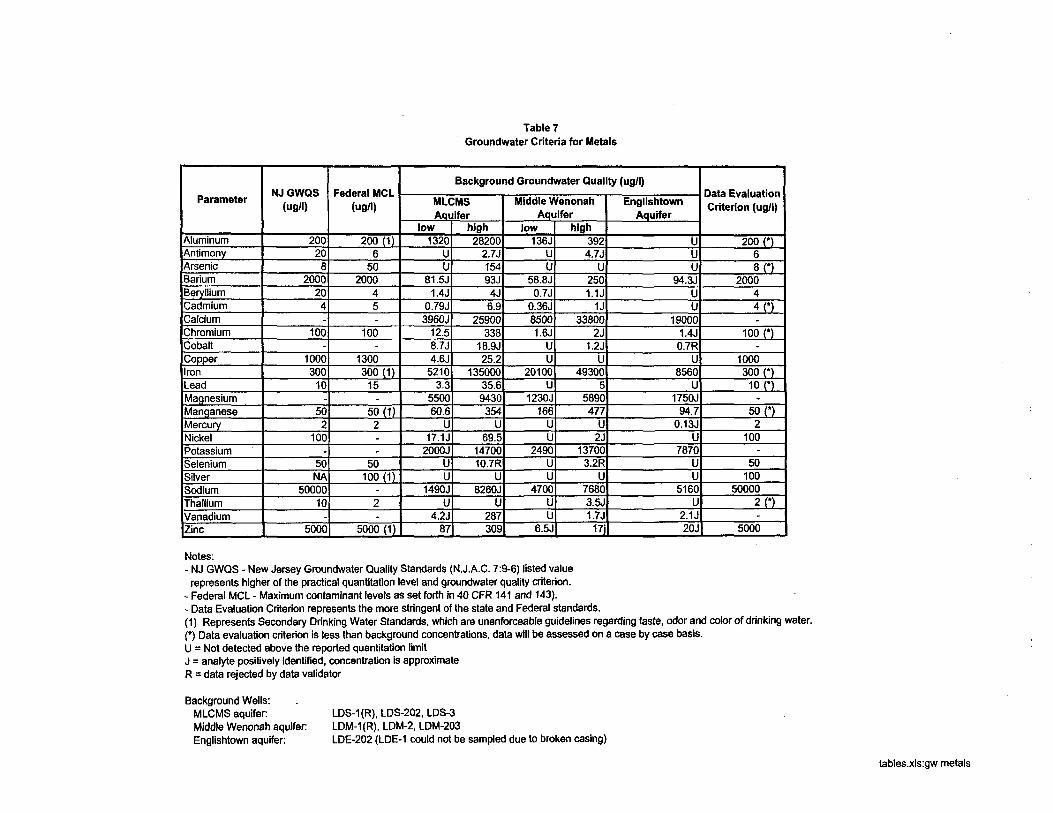
Table 7Groundwater Criteria for Metals
Parameter
AluminumAntimonyArsenicBariumBerylliumCadmiumCalciumChromiumCobaltCopperIronLeadMagnesiumManganeseMercuryNickelPotassiumSeleniumSilverSodiumThalliumVanadiumZinc
NJ GWQS(ug/l)
200208
2000204-
100-
1000300
10-
502
100-
50NA
5000010
-5000
Federal MCL(ug/1)
200 (116
502000
45-
100-
1300300 (1)
15-
50(1)2.-
50100 (1)
-
2-
5000(1)
Background Groundwater Quality (ug/l)
MLCMSAquifer
low1320
UU
81. 5J1.4J
0.79J3960J
12.58.7J4.6J
52103.3
550060.6
U17.1J
2000JUU
1490JU
4.2J87
high28200
2.7J15493J4J6.9
25900338
18.9J25.2
13500035.69430354
U69.5
1470010.7R
U8260J
U287309
Middle WenonahAquifer
low136J
UU
58.8J0.7J
0.36J85001.6J
UU
20100U
1230J166
UU
2490UU
4700UU
6.5J
high3924.7J
U2501.1JU
338002J
1.2JU
493005
5890477
U2J
137003.2R
U76803.5J1.7J17j
EnglishtownAquifer
UUU
94.3JUU
190001.4J0.7R
U8560
U1750J
94.70.13J
U7870
UU
5160U
2.1J20J
Data EvaluationCriterion (ug/l)
200 (*)6
8O2000
44(*)-
100 n-1000soon
10 n-
son2
100-
50100
500002D-
5000
Notes:- NJ GWQS - New Jersey Groundwater Quality Standards (N.J.A.C. 7:9-6) listed valuerepresents higher of the practical quantitation level and groundwater quality criterion.
- Federal MCL - Maximum contaminant levels as set forth in 40 CFR 141 and 143).- Data Evaluation Criterion represents the more stringent of the state and Federal standards.(1) Represents Secondary Drinking Water Standards, which are unenforceable guidelines regarding taste, odor and color of drinking water.(*) Data evaluation criterion is less than background concentrations, data will be assessed on a case by case basis.U = Not detected above the reported quantitation limitJ = analyte positively Identified, concentration is approximateR = data rejected by data validator
Background Wells:MLCMS aquiferMiddle Wenonah aquifer:Englishtown aquifer:
LDS-1(R), LDS-202, LDS-3LDM-1(R), LDM-2, LDM-203LDE-202 (LDE-1 could not be sampled due to broken casing)
tables.xls:gw metals
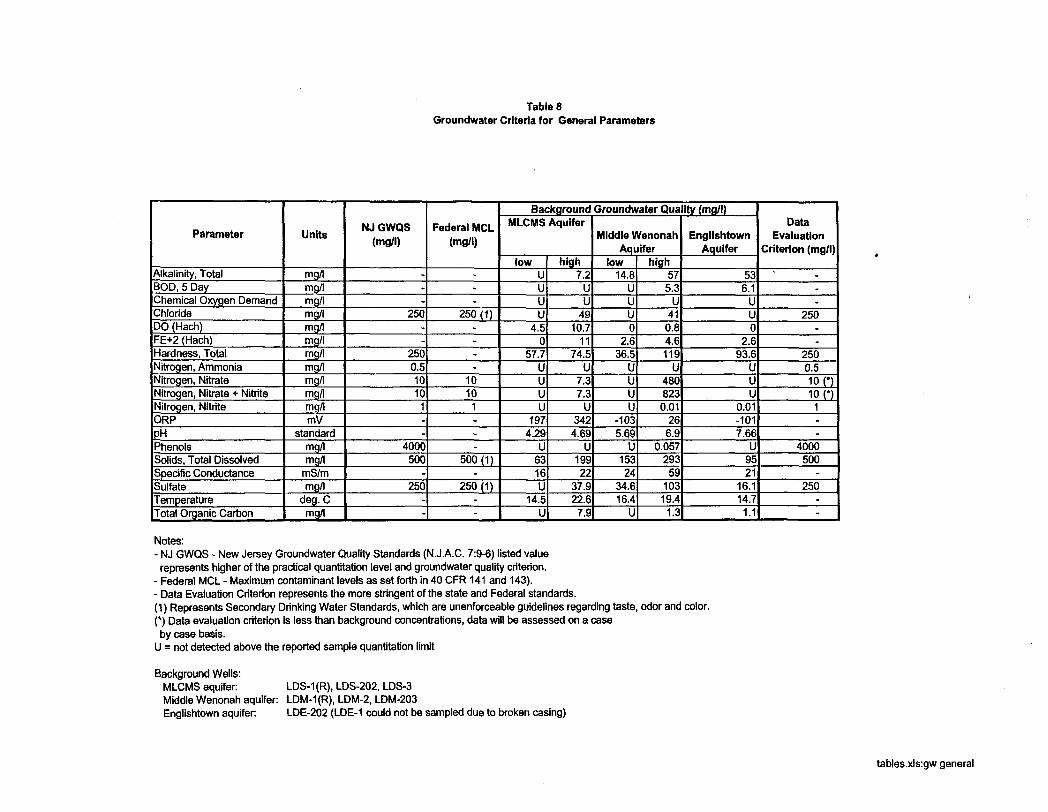
Table 6Groundwater Criteria for General Parameters
Parameter
Alkalinity, TotalBOD, 5 DayChemical Oxygen DemandChlorideDO (Hach)FE+2 (Hach)Hardness, TotalNitrogen, AmmoniaNitrogen, NitrateNitrogen, Nitrate + NitriteNitrogen, NitriteORPPHPhenolsSolids, Total DissolvedSpecific ConductanceSulfateTemperatureTotal Organic Carbon
Units
mg/lmg/lmg/lmg/lmg/lmg/lmg/lmg/lmg/lmg/lmg/lmV
standardmg/lmg/l
mS/mmg/l
deg. Cmg/l
NJ GWQS(mg/l)
---
250--
2500.510101--
4000500
-250
--
Federal MCL(mg/l)
---
250 (1)----
10101---
500 (1)-
250 (1)--
Background Groundwater Quality (mg/l)MLCMS Aquifer
lowUUUU
4.50
57.7UUUU
1974.29
U6316U
14.5U
high7.2
UU
4910.7
1174.5
U7.37.3
U342
4.69U
19922
37.922.67.9
Middle WenonahAquifer
low14.8
UUU0
2.636.5
UUUU
-1035.69
U15324
34.616.4
U
high575.3
U410.84.6119
U4808230.01
266.9
0.05729359
10319.41.3
EnglishtownAquifer
536.1
UU0
2.693.6
UUU
0.01-1017.66
U9521
16.114.71.1
DataEvaluation
Criterion (mg/l)
".-
250.-
2500.510 010 n1--
4000500
-250
--
Notes:- NJ GWQS - New Jersey Groundwater Quality Standards (N.J.A.C. 7:9-6) listed valuerepresents higher of the practical quantitation level and groundwater quality criterion.
- Federal MCL - Maximum contaminant levels as set forth in 40 CFR141 and 143).- Data Evaluation Criterion represents the more stringent of the state and Federal standards.(1) Represents Secondary Drinking Water Standards, which are unenforceable guidelines regarding taste, odor and color.(*) Data evaluation criterion is less than background concentrations, data will be assessed on a caseby case basis.
U = not detected above the reported sample quantitation limit
Background Wells:MLCMS aquifer: LDS-1 (R), LDS-202, LDS-3Middle Wenonah aquifer: LDM-1 (R), LDM-2, LDM-203Englishtown aquifer LDE-202 (LDE-1 could not be sampled due to broken casing)
tables.xls:gw general
APPENDIX I
ADMINISTRATIVE RECORD INDEX
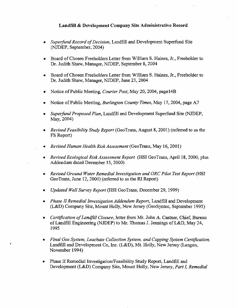
Landfill & Development Company Site Administrative Record
• Superfund Record of Decision, Landfill and Development Superfund Site(NJDEP, September, 2004)
• Board of Chosen Freeholders Letter from William S. Raines, Jr., Freeholder toDr. Judith Shaw, Manager, NJDEP, September 8, 2004
• Board of Chosen Freeholders Letter from William S. Haines, Jr., Freeholder toDr. Judith Shaw, Manager, NJDEP, June 23, 2004
• Notice of Public Meeting, Courier Post, May 20, 2004, pageHB
• Notice of Public Meeting, Burlington County Times, May 17, 2004, page A7
• Superfund Proposed Plan, Landfill and Development Superfund Site (NJDEP,May, 2004)
• Revised Feasibility Study Report (GeoTrans, August 8, 2001) (referred to as theFS Report)
• Revised Human Health Risk Assessment (GeoTrans, May 16, 2001)
• Revised Ecological Risk Assessment Report (HSI GeoTrans, April 18, 2000, plusAddendum dated December 15, 2000)
• Revised Ground Water Remedial Investigation and ORC Pilot Test Report (HSIGeoTrans, June 12, 2000) (referred to as the RI Report)
• Updated Well Survey Report (HSI GeoTrans, December 29, 1999)
• Phase II Remedial Investigation Addendum Report, Landfill and Development(L&D) Company Site, Mount Holly, New Jersey (GeoSyntec, September 1995)
• Certification of Landfill Closure, letter from Mr. John A. Castner, Chief, Bureauof Landfill Engineering (NJDEP) to Mr. Thomas J. Jennings of L&D, May 24,1995
• Final Gas System, Leachate Collection System, and Capping System Certification,Landfill and Development Co, Inc. (L&D), Mt. Holly, New Jersey (Langan,November 1994)
• Phase II Remedial Investigation/Feasibility Study Report, Landfill andDevelopment (L&D) Company Site, Mount Holly, New Jersey, Part I, Remedial
Investigation Report (GeoSyntec, January 1994)
Final Draft, Phase II Remedial Investigation/Feasibility Study, Landfill andDevelopment (L&D) Company Site, Mount Holly, New Jersey, Part HI,Feasibility Study Report (GeoSyntec, September 1993)
Phase II Remedial Investigation/Feasibility Study Report, Landfill andDevelopment (L&D) Company Site, Mount Holly, New Jersey, Part II, BaselineRisk Assessment Report (GeoSyntec, August 1993)
Administrative Consent Order II, July 1990
Soil Gas Survey, Landfill and Development Landfill, Mt. Holly, New Jersey (RoyF. Weston, April 1989)
Phase I Sampling Report, L&D Site RI/FS, Mt. Holly, New Jersey (Baker/TSA,July 1988)
Administrative Consent Order, January 1988
Interim Background Investigation, L&D Site RI/FS, Mount Holly, New Jersey(Baker/TSA, March 1987)
Hydrogeologic Investigation and Assessment, L&D Landfill, Mt. Holly, NewJersey (Fred C. Hart Associates, Inc., January 1986)
Hydrogeologic Investigation in the Vicinity of the L&D Landfill, BurlingtonCounty, New Jersey (Geraghty & Miller, Inc., November 1983)
Groundwater Withdrawal Project, Report of Anticipated Aquifer Response(Wehran Engineering, April 1977)
Investigation of Soil and Conditions, Sanitary Landfill, Mt. Holly, New Jersey, forLandfill and Development Company (Dames & Moore, October 1973)
Letter from Jacqueline E. Schafer, USEPA Regional Administrator to SenatorFrank R. Lautenberg, August 17,1983
Letter from Senator Frank R. Lautenberg to USEPA Congressional RelationsOffice, June 24, 1983
APPENDIX II
EPA LETTER OF CONCURRENCE
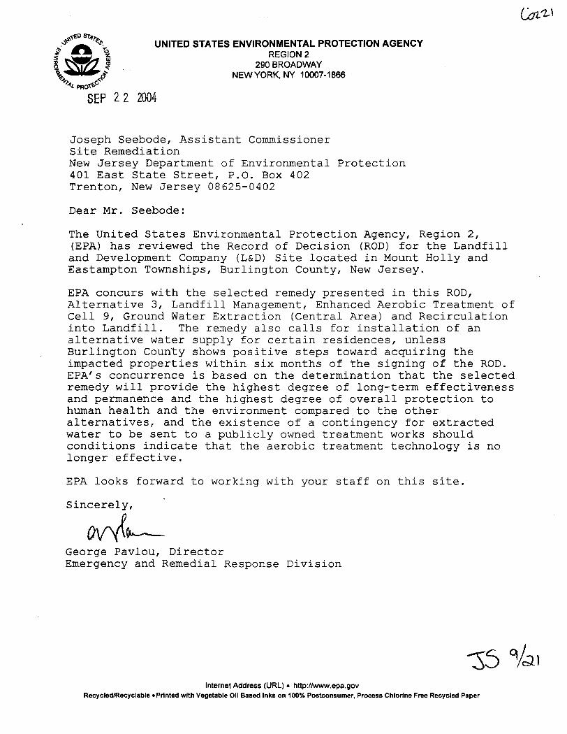
\ UNITED STATES ENVIRONMENTAL PROTECTION AGENCY\ REGION 2? 290 BROADWAY
NEW YORK, NY 10007-1866
""SEP 22 2004
Joseph Seebode, Assistant CommissionerSite RemediationNew Jersey Department of Environmental Protection401 East State Street, P.O. Box 402Trenton, New Jersey 08625-0402
Dear Mr. Seebode:
The United States Environmental Protection Agency, Region 2,(EPA) has reviewed the Record of Decision (ROD) for the Landfilland Development Company (L&D) Site located in Mount Holly andEastampton Townships, Burlington County, New Jersey.
EPA concurs with the selected remedy presented in this ROD,Alternative 3, Landfill Management, Enhanced Aerobic Treatment ofCell 9, Ground Water Extraction (Central Area) and Recirculationinto Landfill. The remedy also calls for installation of analternative water supply for certain residences, unlessBurlington County shows positive steps toward acquiring theimpacted properties within six months of the signing of the ROD.EPA's concurrence is based on the determination that the selectedremedy will provide the highest degree of long-term effectivenessand permanence and the highest degree of overall protection tohuman health and the environment compared to the otheralternatives, and the existence of a contingency for extractedwater to be sent to a publicly owned treatment works shouldconditions indicate that the aerobic treatment technology is nolonger effective.
EPA looks forward to working with your staff on this site.
Sincerely,
George Pavlou, DirectorEmergency and Remedial Response Division
VcaiInternet Address (URL) • http://www.epa.gov
Recycled/Recyclable 'Printed with Vegetable Oil Based Inks on 100% Postconsumer, Process Chlorine Free Recycled Paper
APPENDIX III
RESPONSIVENESS SUMMARY
Responsiveness Summary
This responsiveness summary is divided into the following sections:
A. OverviewB. Background on Community Involvement and ConcernsC. Summary of Comments Received during the Public Comment Period and NJDEP
responses.
A. Overview
This is a summary of the comments and questions from the public regarding the ProposedPlan, dated May 2004, for remediation of the ground water at the Landfill &Development (L&D) Superfund Site, and the New Jersey Department of EnvironmentalProtection's (NJDEP) and U.S. Environmental Protection Agency's (USEPA) responsesto those comments and questions.
A public comment period was held from May 20, 2004 through July 21, 2004 to provideinterested parties the opportunity to comment on the Proposed Plan for the L&D site.During the comment period, the NJDEP held a public meeting on May 24, 2004 at 7:00PM at the Burlington County Human Services Building to discuss results of the RemedialInvestigation and Feasibility Study (RI/FS) reports and to present the NJDEP/USEPApreferred alternative for remediation of the site. NJDEP also attended a meeting on July15, 2004 with members of the Rancocas Creek Association to discuss these items.
The selected alternative includes enhanced treatment of a portion of the landfill inconjunction with ground water extraction in the Central Area. The Proposed Plan's suiteof remedial alternatives were developed for remediation of the site in accordance with theComprehensive Environmental Response, Compensation and Liability Act of 1980(CERCLA), as amended, and the National Oil and Hazardous Substances PollutionContingency Plan (NCP).
B. Background on Community Involvement and Concerns
There has been a great deal of community involvement in the L&D site over the years.Many of the concerns go back to the mid-70's when sampling by Burlington CountyHealth Department first indicated contamination in several of the private wells in thearea. The site received attention from area residents, municipal, state, county and federalofficials as well as the media. In 1984 Senator Hart visited the site as part of hispresidential campaign. Concerned residents petitioned Senator Lautenberg to take actionon the site.
A primary concern of the community has always been the ground water contamination.Residents also voiced concerns about offensive odors. The Rancocas Creek Association
has been involved with the site for many years. Other issues of concern have focused onthe potential environmental and public health risks posed by the site.
C. Summary of Comments Received during the Public Comment Period andNJDEP/USEPA responses
Proposed Treatment
COMMENT 1:
Will the extra ground water extracted (up to 30 gallons/minute or 50,000 gals/day) put astrain on the Mount Holly Sewage Authority (MHSA)? Will it need to raise rates toaccommodate the extra flow?
RESPONSE 1:
No, for the first two years the ground water is going to be re-injected back into thelandfill. Following those two years, the ground water will be sent to the MHSA. At thatpoint we expect the quantity that needs to be sent to the MHSA to diminish. L&D hasspoken with the MHSA to ensure they have adequate capacity. The amount this projectcontributes is minimal compared to the authority's overall capacity.
COMMENT 2:
Why do you discuss a five-year timeline for the proposed remedial action?
RESPONSE 2:
We based that on what has been seen at other sites, also taking into account the levels ofcontaminants we see here. We expect two years of active treatment and then we areestimating another three years of natural attenuation and extraction of leachate that willbe sent to the treatment plant.
COMMENTS:
Would you look at options four and five if the treatment was not working?
RESPONSES:
We may, but first we would likely install additional extraction wells, continue extractionand off-site disposal of the leachate to the MHSA. Problems with the selected remedycan be addressed through the mandatory five-year review that will be conducted byNJDEP.
COMMENT 4:
The installation and use of the ground water recirculation system has the potential torelease VOCs, besides methane and other odor causing agents. No holes or trenches intothe contents of the landfill should be left open overnight during the installation or use ofthe leachate recirculation system in order to minimize odors. Please define the monitoringplan for the atmosphere near cell 9, and let those living close to this operation know ofthe plan.
RESPONSE 4:
L&D will monitor the air at the work site for particulates and all contaminants of concernand will take all necessary steps to minimize odors, including covering holes and trenchesif necessary. The detailed air monitoring plan will be placed in the document repositoryonce it is developed.
COMMENT 5:
Will the community be given the opportunity to review and comment on the specificremediation plan design?
RESPONSE 5:
We will notify those that attended the public meetings that the design is available forreview at the repository (Burlington County Public Library). We can hold a publicmeeting to discuss the design if it is desired.
COMMENT 6:
It was requested that results of monitoring wells be made easily available to thoseaffected. Specifically, it was requested that any property owner within 1000 ft. of a testsite that does not meet water quality standards be notified of the test result.
RESPONSE 6:
We are not equipped to furnish results on a broad and continuing basis like this. We willrespond to individual requests for information. We also can put the information in therepository and investigate making it available electronically.
COMMENT 7:
The Proposed Plan focuses on Cell #9. How do we know other portions of the landfillwon't be problems later on?
RESPONSE 7:
Over the last several years we have seen diminishing levels of contamination outside ofthe Central Area. The conditions in the landfill are relatively stable and we do not expectsignificant deterioration to occur. There will be long-term monitoring of the groundwater.
Water Line
COMMENT 8:
What is the role of Green Acres in the waterline process?
RESPONSE 8:
Burlington County already purchased properties in the area through the use of GreenAcres funds. Any significant change of use of these properties (such as running a waterline through them) requires a variance from the Green Acres program.
COMMENT 9:
What if Green Acres says no to the variances?
RESPONSE 9:
L&D would need to look at other options to provide potable water to residences onRabbit Run.
COMMENT 10:
Please keep us up to date on the Green Acres process.
RESPONSE 10:
We will contact the Rancocas Creek Association as requested.
COMMENT 11:
What is the purpose of the access agreements and when will we see them?
RESPONSE 11:
An access agreement must be signed by the property owners to allow the water line to beinstalled. Most of the agreements are already signed. L&D Company will be in contactwith those property owners who have not signed agreements in the near future.
COMMENT 12:
When is installation of water line anticipated to start?
RESPONSE 12:
If the County provides written documentation to NJDEP by March 30, 2005 that theproperties along Rabbit Run and Hand Lane will be acquired by March 2006, orotherwise satisfactorily demonstrate to NJDEP that it will acquire the properties in areasonable timeframe, then the water line will not be installed. If this documentation isnot provided, then it should take approximately six to nine months after the March 30,2005 County deadline for Green Acres to issue the variances for the water line. Waterline construction should be completed six to nine months after Green Acres approval.
COMMENT 13:
It is the view of Burlington County that acquisition of the properties along Rabbit Run isthe only means to address issues affecting the area. These issues include flooding, effectson water quality from septic systems and open space preservation. Burlington Countyhas requested DEP to reconsider installation of the water line on Rabbit Run and HandLane in order to allow for Burlington County to initiate acquisition of the properties.
RESPONSE 13:
We can defer the implementation of the water line for six months pending the timelyinitiation of the purchase process by the county. Details regarding this extension areincluded in the ROD.
COMMENT 14:
All residences in there area should be connected to public water supply.
RESPONSE 14:
Many residents in the vicinity of the landfill are already connected to a municipal waterline. The remaining residents within the area potentially impacted by the landfill will beconnected by the water line extension.
Private Wells
COMMENT 15:
What is meant by the decommissioning of wells? Will private wells still be allowed foragricultural use?
RESPONSE 15:
As part of the overall project of installing waterlines the municipality may decide to nolonger allow wells used for non-potable purposes. In that case, those wells would need tobe sealed once homes are connected to public water supplies. The municipality willmake this decision.
COMMENT 16:
The proposed plan calls for a temporary or perhaps permanent use restriction on privatewells in the entire area. The function of this plan is supposed to be to return the groundwater to New Jersey drinking water quality standards. Therefore, any water userestrictions should be specific to use for human consumption, they should be temporaryand should be specific to wells into the Wenonah aquifer only. In addition if NJDEPnotifies local government of contamination in the wells and recommends usagerestrictions, it should take responsibility to follow this action by again notifying thosegovernment bodies when the water quality has been improved and recommend therestrictions be lifted.
RESPONSE 16:
Wells are typically sealed to avoid situations where residents are knowingly orunknowingly using their water for potable purposes. It is difficult to ensure water is notused for potable purposes when changes are made at transfer of ownership. It is possiblein this instance that the restriction is only put in place on use of the upper two aquifers.
COMMENT 17:
The water from my well turns my laundry and dishes orange. There also is a concern thatit may be causing infections.
RESPONSE 17:
The orange color most likely comes from the elevated iron in the ground water andsurface water in the area. It is recommended that the owner test their well for coliformbacteria to look for an indication of harmful bacteria in the water.
Rancocas Creek
COMMENT 18:
Are toxic wastes going in the creek?
RESPONSE 18:
While there is a general flow of ground water into the creek and there are elevated levelsof contaminants in the Central Area, the ground water around the bulk of the landfill iscontinuing to improve. Contaminant levels in the creek are within acceptable risk ranges.In addition, if contaminants reach the creek, the amount of water that is in the creekwould provide significant dilution of contaminant levels, and volatile organic chemicals(VOCs) would be able to volatilize to the atmosphere.
COMMENT 19:
Who is testing the creek? Should it be tested on a regular basis?
RESPONSE 19:
There was sampling of the surface water and sediments done a few years ago as part ofthe Remedial Investigation and Risk Assessment by L&D. At the request of the public,additional confirmatory sampling of the creek (surface water) will occur in October 2004.We do not see the need to sample the sediments again since the risk assessment showedthere was no increased risk from the sediments.
COMMENT 20:
Are my children at risk from swimming in the creek?
RESPONSE 20:
The Risk Assessment showed that the landfill is not causing or adding to any risksassociated with the creek. Please note though, that there could be potential concerns forswimmers if weather conditions or malfunctioning septic systems in the area cause highfecal coliform counts in the creek.
COMMENT 21:
Does L&D have the responsibility to test the creek periodically and advise residents ofthe condition of the water?
RESPONSE 21:
If there was an unacceptable risk from an exposure in the creek due to the landfill wewould have required that. Based on this request we have asked L&D to sample the creek.They will do that in October 2004. That is generally a time of year when the flow in thecreek is low and we feel that the sampling would best represent any contribution ofcontaminants coming from the landfill. We will evaluate those results to determinewhether any additional sampling is necessary.
COMMENT 22:
Are there conditions under which the flow of ground water or contaminants will increasewhich would necessitate additional testing of the creek?
RESPONSE 22:
We have sampled the monitoring wells regularly for the past several years and we see thegeneral decrease in contaminant levels. We do not anticipate any dramatic changes fromthose results. The remedy is designed to continue to reduce the flow of contaminants tothe creek.
Surface Water
COMMENT 23:
Are there any breaches of the clay barrier that would affect the surface water runoff?
RESPONSE 23:
No. As part of the general surface water permit issued to L&D, the site is inspected on asemi-annual basis. They have to maintain vegetation and deal with any erosionproblems.
COMMENT 24:
There are problems with the detention basin being loaded with silt and orange water andrunning across roads and properties towards the creek and the canal. The canal isn'tmoving at all, it's a mosquito trap.
RESPONSE 24:
NJDEP will require that L&D address the discharge from the site. Regarding theconcern about mosquitoes in the canal, the Burlington County Mosquito Control can becontacted to address this issue at P.O. Box 6000, 49 Rancocas Road, Mt. Holly, NJ08060. Their phone number is (609) 265-5064.
COMMENT 25:
The discharge from the retention basin (northcentral) goes into a creek and washes outShreve Street where the creek crosses the road.
RESPONSE 25:
NJDEP, along with L&D, will ensure this problem is resolved.
Land Use
COMMENT 26:
Will Burlington County be attempting to acquire the landfill?
RESPONSE 26:
We are not aware of any action of that sort.
COMMENT 27:
Will the landfill be usable for other purposes?
RESPONSE 27:
That determination will be made when the reinjection system is operational and itseffectiveness is monitored.
Cost
COMMENT 28:Who is bearing the cost of the remediation effort?
RESPONSE 28:
The L&D Company will pay for the remedy as well as the operation and maintenancecosts.