Embed Size (px)
Citation preview
1
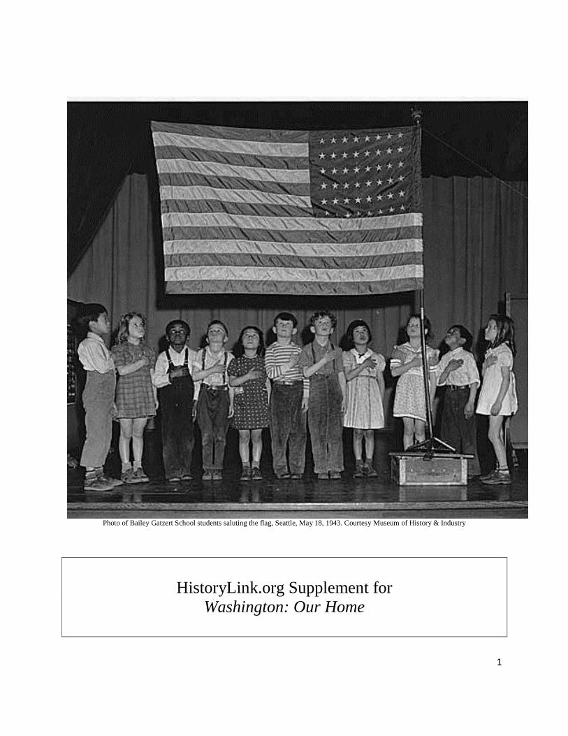
Photo of Bailey Gatzert School students saluting the flag, Seattle, May 18, 1943. Courtesy Museum of History & Industry
HistoryLink.org Supplement for
Washington: Our Home

2
Washington: Our Home has been identified as the most commonly used
Washington state History textbook for 4th graders for the 2011-12 school year.
Using this textbook as a base for identifying the specific themes and topics that are
being covered in required Pacific Northwest History elementary school classes, the
Education Team at HistoryLink.org has created this supplement for teacher and
students.
This supplement was developed as a tool to assist in identifying HistoryLink.org
essays that can be used to study and research the state history themes and topic in
more depth. The name of each relevant essay is listed as well as the abstract,
number, and link to the full essay. This supplement also aids HistoryLink.org in
identifying general or specific topics for which more essays are needed or would
be helpful in the Washington state History classroom. In addition, as a part of this
exercise, HistoryLink.org staff assigned appropriate key words to selected essays
to match those used in this textbook.
A set of HistoryLink Elementary essays was added to the HistoryLink
encyclopedia in 2014. (http://www.historylink.org/Index.cfm?DisplayPage=education/elementary-
educators.cfm.) These essays were written for third and fourth grade students who are
studying Washington State History and for all beginning readers who want to learn
more about Washington. All HistoryLink Elementary essays are based on existing
HistoryLink essays. They have been listed under appropriate pages that match the
specific topics in the Washington: Our Home textbook.
The plan is to update this supplement prior to the beginning of each semester by
identifying and adding relevant essays as written by HistoryLink.org historians.
Please contact [email protected] with questions and comments.
Prepared by Education Team, Patricia L, Filer (Education Director) and Claire
Palay (Education Intern) 2011. Updated 8/14

3
Washington: Our Home (copyright 2010)
UNIT 1: SETTING THE STAGE
Chapter 1: What is History?
Chapter 2: Geography is the Stage
UNIT 2: BECOMING WASHINGTON
Chapter 3: Native People
Chapter 4: Explorers and Fur Traders
Chapter 5: Early Immigrants and Settlement
Chapter 6: Territories and Treaties
UNIT 3: LIVING IN WASHINGTON
Chapter 7: Our Government
Chapter 8: Working in Washington
RESOURCES
State Symbols
State Songs
Atlas
Glossary
Index

4
Washington State History teachers,
Please find abstracts from selected relevant essays, cyberpedias, timelines, or
people’s histories that align with each name, place, or theme found on individual
pages in the Washington: Our Home textbook.
p. 7 - How Seattle was named
HistoryLink Elementary: Chief Seattle Chief Seattle's parents were from tribes on both sides of Elliott
Bay and the Duwamish River. He lived during a time of change for his people and the Puget Sound
region. He welcomed the Collins and Denny parties when they arrived as the first pioneer families in the
Seattle area. Chief Seattle was considered a peacekeeper between the settlers and his people. He was
respected so much that the new city was named in his honor. File 10736: Full Text >
Chief Seattle (Seattle, Chief Noah [born si?al, 178?-1866]) Chief Seattle, or si?al in his native
Lushootseed language, led the Duwamish and Suquamish tribes as the first Euro-American settlers
arrived in the greater Seattle area in the 1850s. Baptized Noah by Catholic missionaries, Seattle was
regarded as a "firm friend of the Whites," who named the region's future central city in his honor. He was
a respected leader among Salish tribes, signing the Point Elliott (Mukilteo) Treaty of 1855, which
relinquished tribal claims to most of the area, and opposing Native American attempts to dislodge settlers
during the "Indian Wars" of 1855-1856. Chief Seattle retired to the Suquamish Reservation at Port
Madison, and died there on June 7, 1866. This essay includes a sound recording of the correct
pronunciation of Chief Seattle's name, provided by Skagit elder Vi Hilbert (1918-2008). File 5071:
Full Text >
Chief Seattle -- his Lushootseed name and other important words pronounced in Lushootseed by Vi
Hilbert In this sound recording, renowned Skagit elder Vi Hilbert (1918-2008) correctly pronounces
Chief Seattle's name and other common names in Lushootseed, the language of the several Coast Salish
peoples. The recording was done on December 7, 2006, by Janet Yoder, a longtime student of Hilbert's
and who has written on her life and work in preserving the Lushootseed language. The file also contains a
transcription of the tape. File 8156: Full Text >
Chief Seattle's Speech In addition to his namesake city, Chief Seattle (178?-1866) is best remembered
for a speech given, according to pioneer Dr. Henry Smith, on the occasion of an 1854 visit to Seattle of
Isaac Stevens (1818-1862). Stevens was governor and Commissioner of Indian Affairs of Washington
Territory. He visited in January and again in March 1854. Chief Seattle's speech went unnoted in the
written record until October 29, 1887, when the Seattle Sunday Star published a text reconstructed from
admittedly incomplete notes by Dr. Smith. File 1427: Full Text >
HistoryLink Elementary: Princess Angeline, Daughter of Chief Seattle Kikisoblu, the daughter of
Chief Seattle was a friend to early Seattle pioneers. One of the pioneer women, Catherine Maynard,
thought Kikisoblu should have a name that would let everyone know that she was the daughter of a great
chief -- so she renamed her "Princess Angeline." Angeline sold baskets and did laundry to earn her own
living. She lived a very simple life but her new friends looked out for her. File 10737: Full Text >

5
p. 24 – Natural Resources
HistoryLink Elementary: How the Land in Washington Was Formed Land formations in Washington
and the Pacific Northwest were a result of millions of years of changes in weather conditions and the
environment. Glaciers and other geological forces created islands, mountains, lakes, and other specific
land formations. File 10740: Full Text >
HistoryLink Elementary: Olmsted Parks of Seattle By 1903, Seattle had five major public parks but
city officials wanted more. They hired the Olmsted Brothers, a landscape architecture company from
Massachusetts, to help create more parks. John C. Olmsted came to Seattle to explore the area, identify
special places and natural resources, and design a great system of parks and boulevards for residents and
visitors. File 10747: Full Text >
p. 30 - Eruption of Mt. St. Helens
HistoryLink Elementary: Mount St. Helens Erupts Mount St. Helens once was the fifth-highest
mountain in Washington. Now, because of a huge eruption on May 18, 1980, it is only the 30th highest
peak in the state. There were many signs that the mountain was going to erupt before it finally did. Some
people took the warnings seriously and some did not. There was terrible damage to the property
surrounding the mountain and many lives were lost. But it was not the first time that Mount St. Helens
had erupted. Diaries of early explorers and missionaries -- and many stories or legends passed down
through Native American tribes -- describe volcanic eruptions that happened long ago. File 10738: Full
Text >
Mount St. Helens erupts on May 18, 1980. On May 18, 1980 at 8:32 a.m., the earth rumbles underneath
Mount St. Helens, a peak in Skamania County in southwestern Washington. Moments later an explosion
blasts away a side of the mountain in a major volcanic eruption. The volcano causes the deaths of 57
people. The destruction is widespread but especially severe in Clark County as boiling gas and mud scour
200 square miles of forest and 30 miles of State Route 504. Some 1,000 miles of state highways and roads
have to be closed, some for months, and highway repairs alone run into hundreds of millions of dollars.
File 5457: Full Text >
p. 30 – volcanoes – Mt. Rainier, Mt. Baker, Mt. Adams, Glacier Peak
HistoryLink Elementary: Mount St. Helens Erupts Mount St. Helens once was the fifth-highest
mountain in Washington. Now, because of a huge eruption on May 18, 1980, it is only the 30th highest
peak in the state. There were many signs that the mountain was going to erupt before it finally did. Some
people took the warnings seriously and some did not. There was terrible damage to the property
surrounding the mountain and many lives were lost. But it was not the first time that Mount St. Helens
had erupted. Diaries of early explorers and missionaries -- and many stories or legends passed down
through Native American tribes -- describe volcanic eruptions that happened long ago. File 10738: Full
Text >

6
Mount Rainier erupts on October 19, 1873. On October 19, 1873, at about 4 o'clock p.m. "clouds of
smoke were seen pouring from the highest peak of Mount Rainer [sic]." People continue observing the
outpouring of smoke until clouds obscure the mountain near nightfall. File 5573: Full Text >
p. 37 – Leavenworth
Leavenworth -- Thumbnail History The town of Leavenworth in Chelan County occupies a spectacular
location at the confluence of Wenatchee River and Icicle Creek, over which loom peaks of the North
Cascade Mountains. The Wenatchee Valley was the traditional home of Native Americans, mainly the
Wenatchi Tribe, for whom the Wenatchee River and Icicle Creek provided a limitless supply of salmon.
Then opportunities for mining, logging, fruit growing, and railroad work drew settlers to the area.
Although Leavenworth boomed for a time, it soon suffered from the unrealized promises of all of these
ventures, and the Depression of the 1930s appeared to seal its fate. During the early 1960s two men from
Seattle who had settled nearby inspired the local residents to revive Leavenworth as a tourist theme town.
The alpine setting suggested the perfect motif: a Bavarian village. After several years of heroic
volunteerism and financial sacrifice by longtime residents and crucial outsiders alike, it became
successful beyond their imagining, developing into Washington's second most popular tourist destination,
after Seattle. File 9475: Full Text >
p. 37 – Ellensburg
Ellensburg -- Thumbnail History Ellensburg, the county seat of Kittitas County, is located three miles
from the confluence of the Yakima River and Wilson Creek near the geographic center of Washington.
The site was a gathering place for the Kittitas band of the Yakama Indians and other Columbia plateau
tribes. In 1871 John Shoudy and Mary Ellen Stewart Shoudy founded the town and in 1875 they platted
the first streets. Ellensburg was incorporated in 1884. The Northern Pacific Railroad arrived in 1886, and
the town prospered, becoming a center for banking and commerce and a social hub for farming and
ranching families in the Kittitas Valley. Prosperity enabled Ellensburg to quickly rebuild after the fire of
July 4, 1889. Washington State Normal School (now Central Washington University), chartered in 1891,
became a major employer. On July 1, 1977, the downtown area became a National Historic District, and
provides an important example of Western pioneer architecture. Each Labor Day weekend, the annual
Kittitas County Fair and Ellensburg Rodeo draw world-class rodeo competitors and visitors from around
the region. File 7554: Full Text >
Ellensburg Cybertour This is a Cybertour of historic Ellensburg, including the Downtown Ellensburg
Historic District, the First Railroad Addition Historic District, and the Kittitas County Fairgrounds
District. It was written and curated by Paula Becker with the assistance of Historic Ellensburg, the Kittitas
County Historical Museum, and Ellensburg librarian Milton Wagy. Preparation of this feature was made
possible by an appropriation from the Washington State Legislature administered by the State Department
of Archeology and Historic Preservation. File 7541: Full Text >

7
p. 46 – spear points
HistoryLink Elementary: Prehistoric Tools and Weapons Archaeological finds in various locations
across Washington have helped scientists learn about how the earliest residents of this state lived. File
10744: Full Text >
HistoryLink Elementary: Marmes Rockshelter The Marmes Rockshelter was a very important
archaeological find in Washington. Tools, human bones, and a cremation hearth more than 8,000 years
old were discovered there. But scientists had a big problem -- the site where the Marmes Rockshelter and
other caves were located was going to be flooded as soon as the Lower Monumental Dam was completed.
The scientists worked very hard to learn as much as they could in the time that they had. In the end, they
built structures around the archaeological sites to try to protect them from the water that would fill the
reservoir behind the dam. They hoped that maybe archaeologists in the future could have the opportunity
to study the sites and learn more about the people who used them thousands of years ago. File 10749: Full
Text >
Moises Aguirre and Mark Mickles discover prehistoric Clovis point artifacts in an East Wenatchee
apple orchard on May 27, 1987. On May 27, 1987, while installing an irrigation sprinkler pipe through
an apple orchard on Grant Road in East Wenatchee near the Columbia River, orchard workers Moises
Aguirre and Mark Mickles uncover a cache of 11,000-to 12,000-year-old prehistoric tools known as
Clovis points buried about 20 inches below the surface. Clovis points are spearheads that were used by
prehistoric peoples to hunt. The discovery excites scientific interest worldwide but raises concerns among
members of the Colville Tribe. Portions of the site will be excavated in 1988 and 1990. After each dig the
pits will be back-filled and protected from intrusion by four-ton concrete slabs. File 7966: Full Text >
Emanuel Manis finds mastodon tusks in Sequim on August 8, 1977. On August 8, 1977, Emanuel
"Manny" Manis (1926-2000) unearths mastodon tusks while excavating a dry peat bog on his property on
the southern outskirts of Sequim, Clallam County. The typically marshy area is dry due to a drought that
summer, and conditions are ideal for Manis's intentions of digging out a smaller area within the bog to
create a permanent pond. His backhoe begins bringing up what at first appear to be old logs. He and his
wife Clare soon realize they are looking not at logs, but at tusks nearly eight feet long. They contact
archaeology and paleontology experts who begin excavation of the site, confirming that the tusks and
other bones are those of a mastodon preserved in the wet peat for 13,000 to 14,000 years. An unrelated
bone they soon find embedded in a rib, if indeed a spear tip, provides the first evidence that humans
interacted with these prehistoric proboscidian mammals that resemble our elephant (but with molar teeth
of a different structure). File 8511: Full Text >
Archaeologists unearth artifacts beginning on June 7, 2005, which indicate that Spokane is the
oldest continually occupied human habitation in Washington. Beginning on June 7, 2005,
archaeologists from Eastern Washington University unearth Native American artifacts from People's Park
in Spokane, and their discoveries reveal the site as the oldest continually occupied human habitation in
Washington. The alluvial delta where Latah Creek enters the Spokane River below Spokane Falls
apparently served as a seasonal encampment as far back as 8,000 years ago. The evidence will provide
important clues about the development of indigenous technology and trade throughout the region.
File 8043: Full Text >

8
p. 50 – ancient animals
HistoryLink Elementary: Prehistoric Tools and WeaponsArchaeological finds in various
locations across Washington have helped scientists learn about how the earliest residents of this
state lived. File 10744: Full Text >
Emanuel Manis finds mastodon tusks in Sequim on August 8, 1977. On August 8, 1977, Emanuel
"Manny" Manis (1926-2000) unearths mastodon tusks while excavating a dry peat bog on his property on
the southern outskirts of Sequim, Clallam County. The typically marshy area is dry due to a drought that
summer, and conditions are ideal for Manis's intentions of digging out a smaller area within the bog to
create a permanent pond. His backhoe begins bringing up what at first appear to be old logs. He and his
wife Clare soon realize they are looking not at logs, but at tusks nearly eight feet long. They contact
archaeology and paleontology experts who begin excavation of the site, confirming that the tusks and
other bones are those of a mastodon preserved in the wet peat for 13,000 to 14,000 years. An unrelated
bone they soon find embedded in a rib, if indeed a spear tip, provides the first evidence that humans
interacted with these prehistoric proboscidian mammals that resemble our elephant (but with molar teeth
of a different structure). File 8511: Full Text >
Benjamin Coplen discovers mammoth bones on Hangman Creek in May 1876. In May 1876,
Benjamin Coplen (1843-1912), a homesteader on Hangman (present Latah) Creek south of Spokane,
discovers huge, mysterious bones in a bog near his spring. These fossils and others unearthed by
neighbors are eventually identified as those of the Columbian mammoth. They soon begin circuitous
journeys that will end in major museums in Chicago and New York. File 7512: Full Text >
Climbers find basalt mold and bones of a 15-million-year-old rhinoceros at Blue Lake, Grant
County, in July 1935. In July 1935, two Seattle couples hiking near Blue Lake in Grant County in
Eastern Washington clamber into a cave of basalt. They notice it has an unusual shape, sort of like the
mold of large, upside down animal. They also find a few bones. Word of the bones soon reaches geologist
George Beck at Washington State Normal School (now Central Washington University), who examines
the bones and the cave and determines that the cave is a mold of a rhinoceros that died 15 million years
ago. A basalt flow had covered the dead and bloated beast, preserving a mold of its body in stone. It is
one of the most unusual fossils known. File 9409: Full Text >
Construction at Sea-Tac Airport unearths an extinct giant sloth on February 14, 1961. On Tuesday,
February 14, 1961, while working on a runway at Sea-Tac International Airport, Gordon Simmons of
Sellen Construction Company spots bones sticking out of a recently excavated hole. Digging stops and
paleontologists from the Burke Museum are called in to investigate. They find additional bones,
eventually totaling about 60 percent of the body of a giant sloth, known as Megalonyx jeffersonii. The
extinct animal lived around 12,600 years ago and was the size of Mini Cooper. A display at the Burke
Museum now showcases the discovery, mounted as a complete skeleton. File 9408: Full Text >

9
p. 50 – Kennewick Man
HistoryLink Elementary: Kennewick Man The skull and bones of a man who lived more than 9,000
years ago were discovered in 1996 near Kennewick, Washington. Archaeologists realized that these
remains were very rare. Some wanted to have the opportunity to study them. Native Americans from
around the region wanted to rebury the man they called the Ancient One and respected as an ancestor.
Disagreements about what to do with Kennewick Man have continued through the years. His remains are
currently being held at the Burke Museum in Seattle. File 10741: Full Text >
Kennewick Man A man who lived more than 9,000 years ago along the Columbia River in what is now
central Washington's Tri-Cities area became the center of worldwide attention and heated controversy
following the 1996 discovery of his nearly complete skeleton at a riverside park in Kennewick. Area
Indian tribes sought to rebury the man they called the Ancient One and revered as an ancestor. The
federal government agreed, but eight anthropologists and archeologists sued for the right to study the
skeleton, widely known as Kennewick Man. The case dragged on for years, attended by controversies
over the handling of the bones, the burial of the discovery site, and statements by some plaintiffs,
amplified and distorted in popular accounts, that appeared to suggest Kennewick Man was "Caucasian"
and that Europeans may have reached America before Indians did. Scientific studies, ironically conducted
by the government in an effort to support its decision to turn the remains over to the Indians rather than
allow studies by the plaintiffs, showed that Kennewick Man was not like Europeans, Indians, or any
modern peoples. In early 2004 an appeals court affirmed a prior decision that the plaintiff scientists would
be allowed to study Kennewick Man. File 5664: Full Text >
p. 54 – potlatch
Seattle holds Golden Potlatch festival beginning on July 17, 1911. On July 17, 1911, Seattle holds its first
Golden Potlatch festival. The citywide celebration commemorates the 1897 arrival of the steamer
Portland from Alaska loaded with gold from the Klondike River in Canada. Over the next five days,
approximately 300,000 persons visit Seattle to attend parades, concerts, and demonstrations by
"automobilists" and an aviator. Potlatch is a word (from Chinook Jargon patlac, originally from a Nootka
word) describing a North Coast Native American ceremony (not as such part of the ceremonial repertoire
of Puget Sound tribes) involving a celebration and gift giving. File 2422: Full Text >
p. 55 – salmon
HistoryLink Elementary: Legends from Washington State Tribes For thousands of years, Native
Americans preserved their history in a special way. They passed down their traditions and culture to the
next generation by means of oral tradition -- or storytelling. After the treaties of the 1850s, Washington
tribes were moved on to reservations and Indian children were not allowed to speak their native
languages. Important tribal traditions could have been lost forever. The work of dedicated individuals like
Arthur C. Ballard helped to collect, translate, and save the histories of many Washington tribes. File
10742: Full Text >

10
Salmon Stories of Puget Sound Lushootseed-speaking Peoples For centuries, salmon have been
intrinsic to the culture and subsistence of the Native peoples of King County. For Lushootseed-speaking
groups living along rivers and streams where salmon spawn in the Puget Sound Basin, salmon appeared
frequently in stories and Salmon as a spiritual being was important in spiritual life. This essay describes
the place of salmon in Puget Sound Native culture, spirituality, and story. File 2942: Full Text >
p. 56 – Makah whale hunter
HistoryLink Elementary: Makah Whaling The culture and lifestyle of the Makah Indians is
based on the sea. Their homeland is on the Olympic Peninsula in northwestern Washington,
along the shore of the Strait of Juan de Fuca and the coastline of the Pacific Ocean. They have
hunted gray whales for thousands of years. The tribe used every part of the whale as food, to
make all sorts of needed items, and to trade. When Makah leaders signed the Treaty of Neah Bay
in 1855, they were promised that they could continue to fish and hunt for whales. But
professional whalers hunted gray whales until they were almost extinct. The gray whale was
placed on the Endangered Species list and the Makah were not allowed to hunt it. In 1999,
Makah whalers conducted a traditional whale hunt and landed a whale. Many in the tribe had not
tasted fresh whale blubber before. Since then, the whale hunts have been stopped until new
studies on the environment can be completed. File 10739: Full Text >
Makah Whaling In 1999 and 2000, after a hiatus of seven decades, Makah Indian whalers again hunted
gray whales from their ancestral lands around Cape Flattery on the Olympic Peninsula. The Makah,
whose whaling tradition dates back thousands of years, are the only tribe in the United States with a treaty
guaranteeing the right to hunt whales. Makahs had not whaled since the 1920s, when commercial whaling
nearly wiped out whale populations, but the tribe announced it would resume whaling after the gray
whale was removed from the Endangered Species List in 1994. The decision ignited worldwide
controversy. Some animal rights activists bitterly denounced the Makah, but other groups, from advocates
for indigenous rights to the United States government, supported the tribe's right to hunt. Following legal
battles and physical confrontations with protestors, Makah whalers landed their first whale in more than
70 years on May 17, 1999. A 2000 hunt was not successful, and court decisions put further authorized
hunts on hold (although five whalers killed a whale without permission in 2007) as the Makah, who
continue to assert their treaty right to hunt whales, seek federal approval to continue their tradition.
File 5301: Full Text >
p. 58 – legend of Lake Crescent and other legends
HistoryLink Elementary: Legends from Washington State Tribes For thousands of years, Native
Americans preserved their history in a special way. They passed down their traditions and culture to the
next generation by means of oral tradition -- or storytelling. After the treaties of the 1850s, Washington
tribes were moved on to reservations and Indian children were not allowed to speak their native
languages. Important tribal traditions could have been lost forever. The work of dedicated individuals like
Arthur C. Ballard helped to collect, translate, and save the histories of many Washington tribes. File
10742: Full Text >

11
Arthur Ballard records and translates Native American legends of Puget Sound in 1916. In 1916,
Arthur C. Ballard (1876-1962) begins collecting the legends of the Duwamish, Muckleshoot, Snoqualmie,
and other tribes of Puget Sound, and translates them into English. By interviewing tribal members, he is
able to capture the oral traditions and their variations, in the style that they were spoken. File 2563:
Full Text >
Arthur Ballard records and translates the Snoqualmie tribe's legend of Moon the Transformer
beginning in 1916. Beginning in 1916, Anthropologist Arthur C. Ballard (1876-1962) records and
translates the Snoqualmie tribe's legend of Moon the Transformer, who creates Snoqualmie Falls and
transforms the Dog Salmon. This is a compressed retelling of the story as collected by Ballard from
Snuqualmie Charlie (sia'txted) (b. ca. 1850). File 2586: Full Text >
Arthur Ballard records and translates the Snoqualmie Tribe's legend of origin of the Tolt River
beginning in 1916. Beginning in 1916, Anthropologist Arthur C. Ballard (1876-1962) records and
translates the Snoqualmie tribe's legend regarding the origin of the Tolt River. This file contains the story
as related to Ballard by Snuqualmie Charlie (sia'txted) (b. ca. 1850). File 2587: Full Text >
Arthur Ballard records and translates the Snoqualmie Tribe's legend of origin of the Humpback
Salmon beginning in 1916. Beginning in 1916, Anthropologist Arthur C. Ballard (1876-1962) records
and translates the Snoqualmie tribe's legend regarding the origin of the Humpback Salmon. This file
contains the story as related to Ballard by Snuqualmie Charlie (sia'txted) (b. ca. 1850). File 2589:
Full Text >
Arthur Ballard records and translates the legend of origin of the North Wind Weir on the
Duwamish River beginning in 1916. Beginning in 1916, Anthropologist Arthur C. Ballard (1876-1962)
records and translates the Native American legend regarding the origin of the rocks in the Duwamish
River known as North Wind Weir. This file contains the story of North Wind Weir compiled from several
versions. File 2590: Full Text >
p. 59 – totem poles
Native Americans of Puget Sound -- A Brief History of the First People and Their Cultures Current
scientific data indicate that Native Americans arrived from Siberia via the Bering Sea land bridge about
12,000 years ago, during the last Ice Age. Native Americans in King County, who are united by a
common Lushootseed or Salish language system, believe they were created in this area at the end of an
ancient Myth Age. Major groups or tribes of local native peoples include the Suquamish, Duwamish,
Nisqually, Snoqualmie, and Muckleshoot (Ilalkoamish, Stuckamish, and Skopamish) tribes. They evolved
complex cultural, social, and economic structures, which the invasion of Euro-American settlers in the
mid-1800s almost erased, but which continue today as the tribes struggle for their survival, respect and
renewal. File 1506: Full Text >

12
Shelton, William (1868-1938): Autobiography (1914) William Shelton (1868-1938), cultural leader of
the Tulalip Tribes, spent much of his life attempting to bridge the divide between regional Indians and
whites through traditional storytelling and art. Shelton gained an understanding of his own native culture
through family teachings and by learning from many of his tribal elders. He also was adept at working
with Bureau of Indian Affairs and city government officials, gaining their respect and support. Shelton
spent years mastering the art of wood carving in order to create story poles through which he shared many
of his tribes' cultural teachings. To accompany one of his carved poles, Shelton wrote a booklet published
in 1913 titled Indian Totem Legends, which told the stories of the pole's carved figures. The booklet also
carried the author's autobiography. On January 2, 1914, a longer version of this same piece was published
in The Everett Daily Herald. The narrative that follows is Shelton's full 1914 Daily Herald version. It is a
reprint of "Maker of Tulalip Totem Pole Tells Story of His Life," The Everett Daily Herald, January 2,
1914, p. 1. --Margaret Riddle File 8906: Full Text >
p. 60 – longhouse
The Tulalip Tribes dedicate a new longhouse at the Tulalip Reservation on Treaty Day, January 22,
1914. On January 22, 1914, Indians from the region gather at the Tulalip Reservation to celebrate Treaty
Day and the completion of a new longhouse. Festivities include songs, dances, games and storytelling,
with a dinner at noon. John A. Juleen (1874-1935) of Everett is present to photograph the event.
File 8523: Full Text >
Bridge construction project unearths Tse-whit-zen, a largely intact Klallam Indian village, in a
major archeological discovery on August 16, 2003. On August 16, 2003, workers building a graving
dock for the Washington State Department of Transportation (WSDOT) near Ediz Hook in Port Angeles
uncover a shell midden. Discovery of the refuse pile, and shortly thereafter, many human remains and
artifacts, reveals the largely intact Klallam village of Tse-whit-zen under layers of industrial rubble and
fill. Tse-whit-zen, which occupied the Port Angeles site for at least 2,700 years until supplanted by
industrial development in the nineteenth and twentieth centuries, turns out to be one of the largest and
most significant archeological sites in Washington. In response to the rediscovery of the village, WSDOT
relocates its graving dock project, intended to build replacement sections for the Hood Canal Bridge. The
Tse-whit-zen site provides important insights into Klallam life before and at the time of first contact with
Europeans. File 7343: Full Text >
Seattle's Duwamish Tribe celebrates new Longhouse and Cultural Center on January 3, 2009. On
January 3, 2009, members and descendants of Seattle's First People, the Duwamish Tribe, held a Grand
Opening ceremony at their beautiful new Duwamish Longhouse and Cultural Center (4705 West
Marginal Way SW), which is situated at a traditional riverside village site. File 8894: Full Text >

13
p. 63 – shaman
Smohalla (1815?-1895) A Wanapum spiritual leader, Smohalla founded what became known as the
Dreamer religion, which was based on the belief that if Native Americans shunned white culture and lived
as their ancestors had lived, the Creator would reward them by bringing dead Indians back to life and
ridding Indian lands of white people. His teachings spread rapidly among Columbia Plateau peoples in
the late nineteenth century. To tribes which had been decimated by disease, pushed out of their traditional
homelands, and otherwise dispirited by white encroachment, Smohalla offered hope for a restoration of
freedom and dignity. To many whites, however, he represented a dangerous threat, not only to white
expansion but to efforts to "civilize" the Indians. Widely feared and vilified in his own time, a century
later he was installed in Washington's Centennial Hall of Honor as one of the 100 most influential people
in state history. File 9481: Full Text >
p. 64 – horses come to the plateau
HistoryLink Elementary: Horses Change Life on the Columbia Plateau Hundreds of years ago, the
Native Americans who lived in Washington's Columbia Plateau region had no means of traveling on land
other than walking. That all changed when local Indian groups began to acquire horses. Horses allowed
tribes to travel farther and faster to gather food, hunt, and trade. Tribes placed great value on their horses.
File 10748: Full Text >
European horses arrive on the Columbia plateau in the early 1700s. In the early 1700s, European
horses arrive on the Columbian plateau, having moved north through tribal trade networks from Pueblo
villages located in present-day New Mexico. The Plateau tribes, who formerly traveled by foot or by
canoe, will gradually adopt this new form of transportation, which will transform many of their traditional
lifeways. File 9433: Full Text >
p. 65 – measles and smallpox
Smallpox Epidemic of 1862 among Northwest Coast and Puget Sound Indians This file describes the
1862 smallpox epidemic among Northwest Coast tribes. It was carried from San Francisco on the
steamship Brother Jonathan and arrived at Victoria, British Columbia, on March 12, 1862. White
officials vaccinated as many whites as possible and very few Indians. When Indians camped near Victoria
began dying of smallpox, Vancouver Island authorities forced them to leave. The Indians returned to their
homelands, causing the disease to spread north from Vancouver Island to southern Alaska, and south into
the Puget Sound region. As Robert Boyd writes in his seminal work, The Coming of the Spirit of
Pestilence, "this [Indian] epidemic might have been avoided, and the Whites knew it." Boyd estimates
that from April to December 1862, 14,000 Native Americans perished, about half the Indians living along
the coast from Victoria to Alaska. File 5171: Full Text >

14
p. 69 – Lewis and Clark Expedition
Lewis and Clark Expedition in Washington State, 1805-1806: An Illustrated Cybertour An
illustrated cybertour of the Lewis and Clark Expedition in Washington state. The Corps of Volunteers for
Northwest Discovery (as the expedition was formally named) entered the region of the future state of
Washington in October 1805. The cybertour was written and curated by Cassandra Tate, with photos by
Glenn Drosendahl. File 7062: Full Text >
Lewis and Clark in Washington State In May 1803, the United States purchased Louisiana from
France. The doubling of U.S. territory caused President Thomas Jefferson (1743-1826) to send
Meriwether Lewis (1774-1809) on a Westward expedition to explore the nation's new piece of real estate.
The Corps of Discovery was a party of 33 persons, including Sacagawea, a Shohone Indian, and York, an
African slave. The Corps, under the leadership of Captain Lewis and Captain William Clark (1770-1838),
traveled by foot, horse, and watercraft across North America and back again beginning in Wood River,
Illinois, in May 1804, and returning to St. Louis, Missouri, in August 1806. The period the Corps spent
along the Columbia and Snake rivers and at the mouth of the Columbia -- from October 1805 to May
1806 -- was principally within what is now the state of Washington. File 5556: Full Text >
p. 70 – Bartolome Ferrelo
Pacific Northwest Explorations Before the American Presence In A. D. 458, a Chinese adventurer
named Hwui Shan crossed the Pacific to Mexico, and then followed the Japan current north to Alaska.
Centuries later, in September 1513, Vasco Nunez de Balboa "discovered" the Pacific after struggling
across the swampy Isthmus of Panama. Following that momentous event, Spain dispatched a number of
legendary captains to the West Coast of North America, including Hernando Cortez, Juan Rodriguez
Cabrillo, and Bartolome Ferrelo. In 1579, Britain's pirate Francis Drake sailed off the Oregon coast;
during the early 1740s, Vitus Bering opened the North Pacific to Imperial Russia; during the late 1700s,
English captains James Cook and George Vancouver charted the Pacific including the bays and inlets of
Puget Sound (Vancouver); and in 1786, Comte de La Perouse, representing France, sailed to the Queen
Charlotte islands. File 5449: Full Text >
p. 71 – Juan de Fuca
Pacific Northwest Explorations Before the American Presence In A. D. 458, a Chinese adventurer
named Hwui Shan crossed the Pacific to Mexico, and then followed the Japan current north to Alaska.
Centuries later, in September 1513, Vasco Nunez de Balboa "discovered" the Pacific after struggling
across the swampy Isthmus of Panama. Following that momentous event, Spain dispatched a number of
legendary captains to the West Coast of North America, including Hernando Cortez, Juan Rodriguez
Cabrillo, and Bartolome Ferrelo. In 1579, Britain's pirate Francis Drake sailed off the Oregon coast;
during the early 1740s, Vitus Bering opened the North Pacific to Imperial Russia; during the late 1700s,

15
English captains James Cook and George Vancouver charted the Pacific including the bays and inlets of
Puget Sound (Vancouver); and in 1786, Comte de La Perouse, representing France, sailed to the Queen
Charlotte islands. File 5449: Full Text >
p. 71 – Juan Perez
Spanish Exploration: Juan Perez Expedition of 1774 -- First European Discovery and Exploration
of Washington State Coast and Nueva Galicia (the Pacific Northwest)Juan Perez (Juan Josef Perez
Hernandez), sailing on the frigate Santiago with a crew made up mostly of Mexicans, was the first non-
native to sight, examine, name, and record the islands near British Columbia including what is now
Vancouver Island and Queen Charlotte Island. Perez sailed from Mexico on behalf of Spain, arriving at
the Pacific Northwest during the summer of 1774. He visited Nootka Sound, and was the first to name
Mount Olympus in Washington state (its Spanish name was Cerro Nevada de Santa Rosalia). He sighted
the Strait of Juan de Fuca and much of the costal territory of Washington state. He was the first European
to see and describe Yaquina Head off what we now know as the Oregon coast. He sailed farther along the
costal stretch of California, Oregon, Washington, Canada, and Alaska than any sailor had done before
him. During this mission he peacefully traded with the Haida, carefully recorded facets of their customs
and culture, and mapped and recorded nautical details for others who soon followed his heroic and
historic accomplishments. File 5677: Full Text >
p. 71 – Bruno de Heceta
Spanish Exploration: Hezeta (Heceta) and Bodega y Quadra Expedition of 1775 to Formally Claim
the Pacific Northwest for Spain In March 1775, the second Spanish expedition, commanded by Bruno
de Hezeta (sometimes spelled Heceta), sailed north from Mexico to Nueva Galicia (the Pacific
Northwest). This expedition set forth shortly after Juan Perez (d. 1775) returned from his historic first
European journey to explore and map Spain's farthest frontier on the west coast of the American
continent. The mission of the second Spanish expedition was to successfully take formal possession of the
land and to further exert Spain's claim to Nueva Galicia. Having learned from the difficulties of sailing
only one vessel during the first voyage, this expedition was carried out with three Mexican-built ships.
Naval officers recently transferred to San Blas, Mexico, from the best naval academies in Spain were
expressly recruited for the purpose of helping complete this important expedition. This time, Juan Perez
was second in command. File 5688: Full Text >
p. 72 - Captain James Cook
British explorer Captain James Cook names Cape Flattery on March 22, 1778. On March 22, 1778,
Captain James Cook (1728-1779) names Cape Flattery. The Cape, home to the Makah Indians, and now
part of the Makah Reservation, is the northwesternmost point in the continental United States, and marks

16
the entrance to the Strait of Juan de Fuca. The name that the British explorer bestows is the oldest non-
Indian place name still in use on Washington state maps. File 5035: Full Text >
p. 73 – George Vancouver
Vancouver's Exploration of the North Pacific, 1791-1795 George Vancouver's voyage of 1791-1795
was about the exploration of a new world and staking England's claim there; about cultural encounters
and exchanges of knowledge and ideas. But in terms of looking at the bigger picture, his discoveries and
explorations were about peeling back the layers of an unknown territory and satiating man's hungry desire
to discover the unknown and expand human understanding. Editorial note: This essay by Emily Miller,
age 14, of Coupeville, won top honors in the junior division of the 2004 Washington History Day
competition, and earned a $100 supplemental prize from History Ink/HistoryLink for focusing on a
subject in Washington state history. We are proud to sponsor History Day and will renew our awards for
winning essays in future History Day Programs. File 5708: Full Text >
Vancouver, George (1758-1798) George Vancouver was an important explorer of Puget Sound. He
served for 25 years in the British Navy, and commanded the Discovery on her expedition to the North
Pacific. In April 1792, George Vancouver entered the Strait of Juan de Fuca and commenced his
exploration of Puget Sound. He named every island, mountain, waterway, and point of land in sight -- 75
in all. File 5359: Full Text >
p. 74 – Robert Gray
Captains Robert Gray and George Vancouver meet off the Washington coast on April 28 or 29,
1792. On April 28 (or 29), 1792, two of the first non-Indian navigators to explore significant parts of what
is now Washington meet on the high seas off Cape Flattery, just south of the entrance to the Strait of Juan
de Fuca. Captain George Vancouver (1758-1798) goes on to explore and name much of Puget Sound as
well as Vancouver Island. Captain Robert Gray (1755-1806), an American in search of furs, soon finds
the Columbia River, which Vancouver, like all prior European navigators, has missed, thus giving the
young United States its primary claim to the lands of the Pacific Northwest. File 5049: Full Text >
Captain Robert Gray enters Grays Harbor on May 7, 1792. On May 7, 1792, American fur trader
Robert Gray (1755-1806)enters Grays Harbor, a large natural harbor on the Pacific coast south of the
Olympic Peninsula in present-day Grays Harbor County. Gray, on his second trading voyage to the
Northwest Coast from New England, is exploring the coast south of the Strait of Juan de Fuca following a
year of trading for sea otter and other furs on Vancouver Island. He and his crew are the first whites to
enter Grays Harbor. File 5050: Full Text >
Captain Robert Gray becomes the first non-Indian navigator to enter the Columbia River, which
he later names, on May 11, 1792. On May 11, 1792, American fur trader Robert Gray (1755-1806)
enters the major river of the Pacific Northwest in his ship the Columbia Rediviva. Indian peoples have

17
lived and navigated along Wimahl ("Big River") for tens of thousands of years, and Europeans have been
sailing the Northwest Coast for more than 200 years. However, Gray is the first non-Indian to succeed in
entering Wimahl, which he renames the Columbia River after his ship. File 5051: Full Text >
Captain Robert Gray explores Grays Bay and charts the mouth of Grays River in May 1792.
Around May 14 through 17, 1792, American fur trader Robert Gray (1755-1806) explores Grays Bay on
the Columbia River shore of present-day Wahkiakum County, and charts the outlet of Grays River where
it enters the Bay. Grays Bay is an embayment on the north bank about 20 miles upstream from the mouth
of the Columbia River. The various branches of Grays River rise in the Willapa Hills on the boundary
ridge between Lewis and Wahkiakum Counties in southwest Washington, draining 124 square miles
before flowing into the Columbia at Grays Bay. Both are named for Robert Gray. File 5052: Full Text >
p. 75 – Lewis and Clark
Lewis and Clark Expedition in Washington State, 1805-1806: An Illustrated Cybertour An
illustrated cybertour of the Lewis and Clark Expedition in Washington state. The Corps of Volunteers for
Northwest Discovery (as the expedition was formally named) entered the region of the future state of
Washington in October 1805. The cybertour was written and curated by Cassandra Tate, with photos by
Glenn Drosendahl. File 7062: Full Text >
Lewis and Clark in Washington State In May 1803, the United States purchased Louisiana from
France. The doubling of U.S. territory caused President Thomas Jefferson (1743-1826) to send
Meriwether Lewis (1774-1809) on a Westward expedition to explore the nation's new piece of real estate.
The Corps of Discovery was a party of 33 persons, including Sacagawea, a Shohone Indian, and York, an
African slave. The Corps, under the leadership of Captain Lewis and Captain William Clark (1770-1838),
traveled by foot, horse, and watercraft across North America and back again beginning in Wood River,
Illinois, in May 1804, and returning to St. Louis, Missouri, in August 1806. The period the Corps spent
along the Columbia and Snake rivers and at the mouth of the Columbia -- from October 1805 to May
1806 -- was principally within what is now the state of Washington. File 5556: Full Text >
p. 79 – diary of Lewis and Clark
Lewis and Clark prematurely celebrate their arrival at the Pacific Ocean on November 7, 1805. On
November 7, 1805, thinking he can see and hear the Pacific Ocean in the distance, William Clark writes
his most famous journal entry: "Great joy in camp we are in view of the Ocian, this great Pacific Octean
which we have been so long anxious to See." In fact, the Lewis and Clark Expedition is still 20 miles
from the sea. File 5360: Full Text >

18
p. 80 – Sacagawea and Pomp
Sacagawea statue is unveiled at the State Normal School at Cheney on June 9, 1916. On June 9,
1916, the class of 1916 of the State Normal School at Cheney donates a statue of Sacagawea. The statue
will become an important school symbol. In the fall of 1960, a new modern statue will replace it, but the
original will be re-installed in 2001. During those years the State Normal School at Cheney will become
Eastern Washington College of Education (1937), Eastern Washington State College (1960), and finally,
Eastern Washington University (1977). File 8296: Full Text >
p. 81 – Lewis and Clark meet Nez Perce
Lewis and Clark Expedition enters Washington state on October 10, 1805. On October 10, 1805,
Lewis and Clark and the Corps of Volunteers for Northwestern Discovery enter what is now the state of
Washington, at the confluence of what they call the "Koos koos ke" (Clearwater River) and the
"Kimooenem" or "Lewis's River" (Snake). File 5323: Full Text >
Lewis and Clark reach the confluence of the Snake and Columbia rivers on October 16, 1805. On
October 16, 1805, the Lewis and Clark Expedition reaches the confluence of the Snake and Columbia
rivers at present-day Pasco, beginning the final leg of 4,000-mile journey of exploration from St. Louis,
Missouri, to the Pacific Ocean. File 5337: Full Text >
p. 81 – Lewis and Clark – York
In first election by Americans in the West, the Corps of Discovery votes to winter on the south side
of the Columbia River on November 24, 1805. On November 24, 1805, the Corps of Discovery, led by
Captains Meriwether Lewis and William Clark, votes to spend the winter on the south bank of the
Columbia River. All members of the expedition are allowed to participate. This is the first election by
Americans in the West, and the first election to include a woman, a Native American, and an African
slave. File 7539: Full Text >
p. 87 – Fort Walla Walla
Walla Walla Frenchtown is established about 1824. Around 1824, the Walla Walla Frenchtown is
established near the mouth of the Walla Walla River. The community is associated with the Hudson's Bay
Company post first built by the French Canadian Northwest Company in 1818 as Fort Nez Perces and
later, after the Hudson's Bay Co. and the Northwest Co. merge, renamed Fort Walla Walla. Frenchtown is
a general designation used throughout North America for locations characterized by the early settlement
of people of French extraction. Frenchtowns are often associated with early fur-trading posts, especially
those of the Hudson's Bay Company, but are typically located at some distance from the posts. This
Frenchtown, like others, will outlive the fur-trading posts because its inhabitants will maintain their

19
French Canadian character through common architectural forms, land division patterns, and the Roman
Catholic religion.File 8615: Full Text >
Robert Newell and Joseph Meek reach Fort Walla Walla with the first wagons driven overland to
the Columbia River in September 1840. In September 1840, Robert Newell, Joseph L. Meek, and their
families reach Fort Walla Walla, the Hudson's Bay Company trading post on the Columbia River in
present day Walla Walla County, with three wagons that they have driven laboriously from Fort Hall in
Idaho. Newell and Meek, fur trappers from the Rocky Mountains, are on the way to settle with their
families in Oregon's fertile Willamette Valley. Their wagons are the first to reach the Columbia River
over land, and they open the final leg of what becomes known as the Oregon Trail to wagon traffic.
File 5235: Full Text >
p. 88 – Hudson’s Bay Company
Hudson's Bay Company The Hudson's Bay Company, a fur-trading enterprise headquartered in London,
began operations on the shores of Hudson Bay in 1670. During the next century and a half, it gradually
expanded its network of trading posts west across Canada. In 1821, it merged with its prime rival, the
North West Company out of Montreal, thus acquiring several posts in the Pacific Northwest. Under the
leadership of Governor George Simpson (1787-1860) and Chief Factor John McLoughlin (1784-1857),
the company dominated the land-based fur trade in the Northwest for the next four decades. After the
Oregon Treaty of 1846 settled the international boundary at the 49th parallel, the company gradually
phased out its operations in Oregon and Washington territories and moved its Northwest headquarters to
Vancouver Island. File 9881: Full Text >
p. 88 – Fort Vancouver
Hudson's Bay Company opens Fort Vancouver on March 19, 1825. On March 19, 1825, the Hudson's
Bay Company opens Fort Vancouver on a bluff above the north bank of the Columbia River where the
city of Vancouver, Clark County, is now located. For the next 20 years, the British-owned company, with
its Fort Vancouver headquarters presided over by chief factor Dr. John McLoughlin (1784-1857), is the
leading non-Indian presence in the region. File 5251: Full Text >
David Douglas arrives at Fort Vancouver to begin two years of botanical exploration on April 20,
1825. On April 20, 1825, David Douglas (1799-1834) arrives at Fort Vancouver, the Hudson's Bay
Company's new Columbia River headquarters, in the company of chief factor Dr. John McLoughlin
(1784-1857). The young Scotsman is a collector for England's Horticultural Society, dispatched to the
Northwest Coast to bring back specimens and seeds of the marvelous and new (to Europeans) plants of
the region, for introduction into British gardens and forests. For the next two years, Douglas will use Fort
Vancouver as a base for botanical explorations through much of present-day Washington and Oregon,
where he will collect thousands of specimens of plants ranging from tiny, rare mosses and herbs to the

20
giant and abundant tree that now bears his name, the Douglas fir (Pseudotsuga menzeisii, not actually a
fir, but a member of a Pacific Rim genus). File 7298: Full Text >
Fort Vancouver is renamed Vancouver Barracks on April 5, 1879. On April 5, 1879, Fort Vancouver,
in Clark County, is renamed Vancouver Barracks. This army post will become the oldest on the West
Coast and the most historic in the Northwest. Vancouver Barracks will provide troops in the Indian Wars,
Spanish-American War, World War I, and World War II. However, because Fort Vancouver lacked
adequate maneuver and training space, Fort Lewis in Pierce County will replace it as a major military
installation. In 1946 the post will become an Army Reserve facility, and portions of it will later be turned
over to the U.S. National Park Service's Fort Vancouver National Site, with the final United States Army
parcel closing in 2011 upon completion of a new Army Reserve Center at a different Vancouver location.
File 9326: Full Text >
p. 89 – John McLoughlin
McLoughlin, John (1784-1857) John McLoughlin was once the most powerful man in the Pacific
Northwest. As Chief Factor of the Hudson's Bay Company's Columbia District from 1824 until 1846, he
ruled a domain that stretched from the Rocky Mountains to the Pacific Ocean, as far north as Alaska and
south into California. From his headquarters at Fort Vancouver, he managed an international trading
network, maintained peace among dozens of Indian tribes, and provided critical aid to American
missionaries and settlers. He earned great profits for his company and a respectable fortune for himself.
But his superiors eventually lost faith in him and settlers who had once relied on his kindness and
generosity came to resent his wealth and power. After being forced to resign from the company, he settled
in Oregon City (near today's Portland), a town he had founded years earlier. Congress later passed a law
that denied him legal title to much of the land he had claimed there. He died lonely and embittered in
1857. The honors were belated but abundant. His heirs regained title to the disputed land; his home and
headquarters were preserved as national monuments; his statue was placed in the Capitol Building in
Washington, D.C.; and his name was given to schools, parks, streets, bridges, even a mountain. He was
informally christened the "Father of Oregon" in 1907, a title made official by the Oregon Legislature in
1957, a century after his death. File 10617: Full Text >
Hudson's Bay Company opens Fort Vancouver on March 19, 1825. On March 19, 1825, the Hudson's
Bay Company opens Fort Vancouver on a bluff above the north bank of the Columbia River where the
city of Vancouver, Clark County, is now located. For the next 20 years, the British-owned company, with
its Fort Vancouver headquarters presided over by chief factor Dr. John McLoughlin (1784-1857), is the
leading non-Indian presence in the region. File 5251: Full Text >
Hudson's Bay Company The Hudson's Bay Company, a fur-trading enterprise headquartered in London,
began operations on the shores of Hudson Bay in 1670. During the next century and a half, it gradually
expanded its network of trading posts west across Canada. In 1821, it merged with its prime rival, the
North West Company out of Montreal, thus acquiring several posts in the Pacific Northwest. Under the
leadership of Governor George Simpson (1787-1860) and Chief Factor John McLoughlin (1784-1857),
the company dominated the land-based fur trade in the Northwest for the next four decades. After the
Oregon Treaty of 1846 settled the international boundary at the 49th parallel, the company gradually

21
phased out its operations in Oregon and Washington territories and moved its Northwest headquarters to
Vancouver Island. File 9881: Full Text >
p. 91 – David Thompson (there are a series of timeline essays regarding David Thompson’s
exploration down the river (8676, 8677, 5102, 9006, 9007, 9008, 9009, 9010, 9177, 9178, 9179, 9180,
9181, 8413, 9229 – these three are samples)
Fur trader David Thompson explores the Pend Oreille River in September and October 1809. From
September 27 through October 6, 1809, Canadian explorer David Thompson (1770-1857) scouts the Pend
Oreille River from Lake Pend Oreille in Idaho, downstream through what is now Pend Oreille County in
the northeastern corner of Washington. He and the French Canadian voyageur accompanying him are the
first non-Indians to reach the area. Thompson, a trader, surveyor, and mapmaker for the North West
Company, is exploring the tributaries of the upper Columbia River for sources of beaver and other furs
and for routes to get those furs to market. File 5097: Full Text >
David Thompson plants the British flag at the confluence of the Columbia and Snake rivers on July
9, 1811. On July 9, 1811, at the mouth of the Snake River where it joins the Columbia, Canadian explorer
David Thompson (1770-1857) erects a pole with a sign claiming the surrounding country for Great
Britain. Thompson also leaves a British flag with the Wallula Indians, who control the area. The sign and
flag are a statement to the American fur traders of John Jacob Astor's Pacific Fur Company, who are
competing with Thompson's North West Company of Canada, then still a British colony. The British
claim does not prevail: the confluence of the Snake and Columbia now marks the intersection of Benton,
Franklin, and Walla Walla counties in Washington. File 5096: Full Text >
David Thompson concludes first scientific survey of the Columbia River and departs Kettle Falls
for Montreal on April 22, 1812. On April 22, 1812, David Thompson (1770-1857), Canadian explorer,
geographer, and fur trader, departs Kettle Falls and canoes upstream on the Columbia River, bound for
eastern Canada. Thompson, a partner with the North West Company of Montreal, has recently completed
the first scientific survey of the entire length of the Columbia and is retiring from the fur trade to compile
a series of maps from the data he has collected on his journeys. His completed charts will include the first
accurate rendition of the Inland Northwest north of the Snake River. File 9441: Full Text >
p. 97 – request for missionaries
Catholicism in the Walla Walla Valley Roman Catholics were among the earliest explorers to enter the
Pacific Northwest in the eighteenth century and they were among the earliest settlers in the region in the
nineteenth century. The formal presence of the Roman Catholic Church began in 1838, when the first
priests arrived under the direction of the Hudson's Bay Company, and established missions north and
south of the Columbia River on the Cowlitz and Willamette rivers. A few years later, in 1841, another
Catholic mission arrived from the United States. In 1846, the Northwest became an archdiocese and the
Diocese of Walla Walla, extending between the Cascade and Rocky mountains and the Canadian and
California borders, was established. After the Whitman massacre and resulting battles, the Diocese of
Walla Walla was suppressed in 1853. Although the church tried to maintain its missions in the Walla

22
Walla Valley during the conflicts of the 1850s, church activities were suspended for a few years until
1859, when Catholic institutions began to be established in the area. These included St. Patrick's Church
(1859), St. Vincent's Academy (1864), and St. Mary's Hospital (1879). File 9514: Full Text >
p. 97 – Jason and Daniel Lee
Japanese Castaways of 1834: The Three Kichis The first Japanese known to have visited what is now
Washington state arrived in a dismasted, rudderless ship that ran aground on the northernmost tip of the
Olympic Peninsula sometime in January 1834. The ship had left its home port on the southeast coast of
Japan in October 1832, with a crew of 14 and a cargo of rice and porcelain, on what was supposed to be a
routine journey of a few hundred miles to Edo (Tokyo). Instead, it was hit by a typhoon and swept out to
sea. It drifted across some 5,000 miles of ocean before finally reaching the Northwest coast with three
survivors. Their names were Iwakichi, Kyukichi, and Otokichi. Found and briefly imprisoned by Makah
Indians, the "three kichis" spent several months at Fort Vancouver before being sent on to London and
eventually to China. They became pawns in the diplomatic chess game that governed Japan's relations
with the outside world in the mid-nineteenth century, and were never able to return to their homeland.
File 9065: Full Text >
p. 97 - Father Francis Blanchet
Father Francois (or Francis) N. Blanchet and Rev. Modeste Demers arrive at Fort Vancouver on
November 24, 1838. On November 24, 1838, Father Francois (or Francis) N. Blanchet (1795-1883) and
the Rev. Modeste Demers (1809-1871) arrive at Fort Vancouver. They have traveled from eastern Canada
with the annual Hudson's Bay Co. "express," leaving in May and arriving at Walla Walla on November
18, 1838. They are the first Catholic priests to arrive in the future Washington state. File 7553: Full Text
>
Father Francis (or Francois) N. Blanchet visits Whidbey Island on May 26, 1840. On May 26, 1840,
early missionary Father Francis N. Blanchet (1795-1883) comes to Whidbey Island at the invitation of
Chief Tslalakum. File 5258: Full Text >
p. 98 – Marcus and Narcissa Whitman
Whitman, Narcissa Prentiss (1808-1847) Narcissa Whitman might have lived out her life in historical
obscurity but for two developments. The first was her decision, in 1836, to marry a missionary named
Marcus Whitman and travel with him to what was then called Oregon Country, some 3,000 miles from
her home in upstate New York. The second was her death 11 years later, at the hands of Cayuse Indians at
the mission she and her husband had established near Walla Walla. The Whitmans set out to Christianize
and “civilize” a people they considered “heathen.” They soon gave up trying to convert Indians and

23
instead turned their mission into a way station for white emigrants on the Oregon Trail. Long-simmering
tensions erupted on November 29, 1847, when the Cayuse attacked the mission, killing the Whitmans and
11 others. The attack led to a war against the Cayuse and the extension of federal authority over the
present-day states of Washington, Idaho, and Oregon and parts of Montana and Wyoming. It also helped
make Narcissa – the only woman to be killed – a symbol of the cultural clashes that played out between
whites and Indians throughout the West. File 10088: Full Text >
Whitman-Spalding missionary party arrives at Fort Vancouver on September 12, 1836. On
September 12, 1836, missionaries Marcus Whitman (1802-1847) and Henry Spalding (1803-1874) and
their respective wives, Narcissa (1808-1847) and Eliza (1807-1851), arrive at Fort Vancouver after a
seven-month, 3,000-mile journey overland from their homes in upstate New York. Narcissa and Eliza are
the first white women to cross the Rocky Mountains. The Whitmans will go on to establish a mission
among the Cayuse Indians at Waiilatpu, near present-day Walla Walla, Washington; the Spaldings,
among the Nez Perce at Lapwai, in what is now Idaho. Both missions will be closed after long-simmering
tensions erupt 11 years later and the Cayuse attack the Whitman mission, killing the Whitmans and 11
others. File 9700: Full Text >
Dr. Marcus Whitman establishes a mission at Waiilatpu on October 16, 1836. On October 16, 1836,
Dr. Marcus Whitman (1802-1847), a Presbyterian missionary and a physician, establishes a mission at
Waiilatpu on the Walla Walla River. He chooses the site because of its proximity to the Cayuse tribe and
to the Hudson's Bay Company post at Fort Walla Walla. Whitman will assist many wagon-train
immigrants from the United States, but will convert few of the natives. In 1847, members of the Cayuse
tribe will murder Whitman and other whites at Waiilatpu. File 5191: Full Text >
Missionary women organize the Columbia Maternal Association, the first women's club in the
Northwest, on September 3, 1838. On September 3, 1838, the wives of six pioneer missionaries meet at
the Whitman mission at Waiilatpu (near present-day Walla Walla) and organize the Columbia Maternal
Association, the first women's club in the Northwest. It is the first and only time the charter members --
assigned to widely separated missions -- are able to gather together in person. Instead, the women (and
seven others who join later) hold something like virtual meetings. They set aside an appointed hour, twice
a month, for club activities, sometimes in the company of one or two other women but often alone. The
association continues to function in this manner until 1847, when an Indian attack on the Whitman
mission leads to the closure of all Protestant missions in the Northwest. File 9236: Full Text >
Columbia Maternal Association The Columbia Maternal Association -- the first women's club in what
is now Washington state -- was organized in 1838 by the wives of six pioneer missionaries. Only two of
the women were mothers at the time, but two others were pregnant, and they all expected that motherhood
would be among their primary roles in life. Isolated in what they considered a "heathen land," far from
family and friends, they turned to each other for help in "the right performance of our Maternal duties"
(constitution of the Columbia Maternal Association). The women had been familiar with such groups
through Protestant church circles in their home towns in New England and upstate New York. By creating
an association of their own, they connected not only with each other but with the worlds they had left
behind. File 9272: Full Text >

24
p. 98 – Henry and Eliza Spalding
Whitman-Spalding missionary party arrives at Fort Vancouver on September 12, 1836. On
September 12, 1836, missionaries Marcus Whitman (1802-1847) and Henry Spalding (1803-1874) and
their respective wives, Narcissa (1808-1847) and Eliza (1807-1851), arrive at Fort Vancouver after a
seven-month, 3,000-mile journey overland from their homes in upstate New York. Narcissa and Eliza are
the first white women to cross the Rocky Mountains. The Whitmans will go on to establish a mission
among the Cayuse Indians at Waiilatpu, near present-day Walla Walla, Washington; the Spaldings,
among the Nez Perce at Lapwai, in what is now Idaho. Both missions will be closed after long-simmering
tensions erupt 11 years later and the Cayuse attack the Whitman mission, killing the Whitmans and 11
others. File 9700: Full Text >
Missionaries Marcus and Narcissa Whitman begin their journey to the Northwest, one day
after their wedding, on February 19, 1836. On February 19, 1836 -- one day after their
wedding -- missionaries Marcus Whitman (1802-1847) and Narcissa Prentiss Whitman (1808-
1847) begin a seven-month, 3,000-mile journey from New York State to the Pacific Northwest.
Their goal is to Christianize and "civilize" Indians in what is then known as Oregon Country.
After arriving, they will establish a Protestant mission on Cayuse land at Waiilatpu, near present-
day Walla Walla, Washington. Eleven years later, a group of Cayuses will attack the mission,
killing the Whitmans and 11 others in what will become known as the "Whitman Massacre." File
10777: Full Text >
p. 99 – Catherine Sager
Trial of five Cayuse accused of Whitman murder begins on May 21, 1850. On May 21, 1850, the trial
of five Cayuse men accused of murdering Protestant missionary Marcus Whitman begins in Oregon City,
capital of the newly organized Oregon Territory. Whitman, his wife Narcissa, and 11 others had been
killed during a Cayuse attack on the Whitman Mission near Walla Walla two and a half years earlier. The
defendants were indicted on several charges associated with the attack but were tried on only a single
count, that of "feloniously, wilfully and of their malice aforethought" killing "one Marcus Whitman"
(Grand Jury indictment No. 11). The trial lasts four days and ends when all five defendants are convicted
and sentenced to death by hanging. File 9401: Full Text >
p. 100 – measles and smallpox
Turning Point 16: When Worlds Collide: From Contact to Conquest on Puget Sound The 16th essay
in HistoryLink's Turning Point series for The Seattle Times focuses on the cultural interactions between
Puget Sound's Native peoples and the first European explorers and early settlers. While generally
friendly, Indians suffered greatly through exposure to smallpox and other diseases, and later, deliberate
efforts to occupy their lands and erase their traditions. Greg Lange conducted the primary research for this

25
article, with special review by scholars Kenneth "Greg" Watson and John Findlay, Ph.D. It was written by
Walt Crowley and Priscilla Long and was published in two parts on October 11 and 12, 2001. File 9294:
Full Text >
p. 100 – Cayuse Indians
Cayuse Indians The Cayuse Indians were once masters of a vast homeland of more than six million acres
in what is now Washington and Oregon. The first of the Northwest tribes to acquire horses, they were
relatively few in number but outsized in influence, noted for their shrewd bargaining ability and much
feared as warriors. Fur trader Alexander Ross (1783-1856) described them as "by far the most powerful
and warlike" of the tribes on the Columbia Plateau in 1818. They were at the peak of their power in 1836,
when they invited Marcus (1802-1847) and Narcissa (1808-1847) Whitman to establish a mission on
Cayuse land near Walla Walla. What began as accommodation ended in disillusionment and resentment.
A group of Cayuse attacked the mission in November 1847, killing the Whitmans and 11 others -- a brief
flurry of violence that led to the first Indian war in the Northwest, the creation of Oregon Territory as a
federal entity, and, eventually, a treaty that stripped the tribe of most of its land. But that was not the end
of the story. As historian Clifford Trafzer has pointed out, "Their lives did not end in the last century, and
their cultures did not fade away" (Trafzer, 7). The Cayuse survive as part of the Confederated Tribes of
the Umatilla, with a 172,000-acre reservation near Pendleton, Oregon; an annual operating budget of
nearly $230 million; and businesses ranging from a casino to a wind farm. In the words of a tribal
brochure, "We are still here. We will continue to be here." File 10365: Full Text >
Washington Territorial Volunteers kill 50 Cayuse in the Grande Ronde Valley on July 17, 1856. On
July 17, 1856, Washington Territorial Volunteers under Lieutenant Colonel Benjamin F. Shaw attack a
camp of Cayuse Indians in the Grande Ronde Valley in Oregon Territory. Shaw had been assigned to
suppress hostile tribes and the volunteers made little distinction between hostile, neutral, and friendly
tribes. The volunteers kill at least 50 people, many of them women and children, burn Indian foodstuffs
and 120 lodges, and kill horses. This aggression inflames non-hostile tribes and will be an important
reason that the Second Walla Walla Council fails to result in treaties between the Indians and the United
States. File 8146: Full Text >
U.S. Army Colonel George Wright slaughters 800 Palouse horses on September 8, 1858. On
September 8, 1858, U.S. Army Colonel George Wright (1803-1865) orders his troops to slaughter 800
Native American horses (the herd of a Palouse chief) at Liberty Lake to deny their use by enemy tribes.
Soldiers also destroy native lodges and storehouses of grain. Wright is engaged in a punitive military
expedition against the Yakama, Spokane, Palouse, and Coeur d'Alene tribes, which had defeated
Lieutenant Colonel Edward Steptoe's force on May 17 and 18, 1858. Horses represent both the wealth and
military power of the tribes. The slaughter along with the destruction of the food supply devastates the
tribes. File 5142: Full Text >
U.S. Army Colonel George Wright hangs Yakama and Palouse prisoners at the Ned-Whauld River
beginning on September 25, 1858. Beginning on September 25, 1858, Colonel George Wright (1803-
1865), U.S. Army, hangs Yakama and Palouse prisoners he suspects of killing whites. Wright is engaged
in a punitive military expedition against the Yakama, Palouse, Spokane, and Coeur d'Alene tribes after

26
their defeat of a force under Lieutenant Colonel Edward Steptoe in May. Yakama warrior Qualchan
(alternatively spelled Quaichan, Qualchew, Qualchen, Quilchin, or Quaichien) is hanged 15 minutes after
he surrenders to Wright carrying a white flag. The following day, six Palouse warriors are hanged after
surrendering. Ned-Whauld River, called by the tribes Sin-too-too-olley (river of small fish) Creek, is
thereafter called Hangman's Creek. File 5141: Full Text >
p. 100 – Whitman massacre story has two sides
Cayuse attack mission in what becomes known as the Whitman Massacre on November 29, 1847.
On November 29, 1847, Cayuse tribal members attack white settlers and missionaries at Waiilatpu in
what will become known as the Whitman Massacre. Thirteen whites are killed during three days of
bloodshed, most of them on the first day; another is believed to have drowned after escaping the initial
attack. File 5192: Full Text >
p. 100 – Eliza Spalding Warren (witness to massacre)
Trial of five Cayuse accused of Whitman murder begins on May 21, 1850. On May 21, 1850, the trial
of five Cayuse men accused of murdering Protestant missionary Marcus Whitman begins in Oregon City,
capital of the newly organized Oregon Territory. Whitman, his wife Narcissa, and 11 others had been
killed during a Cayuse attack on the Whitman Mission near Walla Walla two and a half years earlier. The
defendants were indicted on several charges associated with the attack but were tried on only a single
count, that of "feloniously, wilfully and of their malice aforethought" killing "one Marcus Whitman"
(Grand Jury indictment No. 11). The trial lasts four days and ends when all five defendants are convicted
and sentenced to death by hanging. File 9401: Full Text >
p. 102-3 – Mother Joseph
Mother Joseph of the Sisters of Providence (Esther Pariseau) (1823-1902) Mother Joseph of the
Sisters of Providence gained posthumous recognition in 1980, when the U.S. Senate accepted her statue, a
gift from Washington state, for inclusion in the national Statuary Hall Collection. The inscription reads:
"She made monumental contributions to health care, education, and social work throughout the
Northwest." Known as "the Builder," Mother Joseph designed and/or supervised construction of 29
schools and hospitals, one of which was Seattle's first hospital. She is recognized as one of the first
architects in Washington Territory. File 5483: Full Text >
Sisters of Providence arrive at Fort Vancouver on December 8, 1856. On December 8, 1856, five
Sisters of Providence, Roman Catholic nuns, arrive at Fort Vancouver, Washington. Sister Joseph
(formerly Esther Pariseau) (1823-1902) is their leader. She will later be known as Mother Joseph, the
Northwest's first architect. File 5207: Full Text >

27
The Sisters of Providence establish St. Vincent's Academy in Walla Walla on February 18, 1864. On
February 18, 1864, at the request of John Baptist Abraham Brouillet (1813-1884), who has oversight of
Roman Catholic St. Patrick's Church in Walla Walla, three Sisters of Providence arrive to establish St.
Vincent's Female Academy at the church. Construction of a two-story building for the school and a
convent is still underway, but planning begins for opening the school. The unfinished building will be
dedicated on Sunday, February 28, registration will occur on Monday, and classes will begin on Tuesday.
The school will quickly grow and a hospital, St. Mary's, will emerge out of it in 1879. During the
twentieth century, St. Vincent's will become part of a comprehensive parochial system in Walla Walla.
File 9517: Full Text >
p. 104 – Oregon Trail
A Story of Pioneering by Nicholas V. Sheffer (1825-1910), Part 1: Oregon Trail In 1909, Nicholas
Sheffer (1825-1910) was Whatcom County's oldest pioneer. He prepared his reminiscences for The
Lynden Tribune, which ran them in three parts in August of that year as "A Story of Pioneering: Being a
Personal Narrative of Early Days in Northwest Washington, told to the Tribune by N. V. Sheffer, of
1854." HistoryLink.org was made aware of this account by Whatcom County family historian Susan
Nahas who connected Sheffer's information with the HistoryLink.org story of Julia Benson Intermela
(1855-1907), the half-Duwamish daughter of Seattle pioneer Henry Yesler (1810-1892). In Part 1 Sheffer
treks from Indiana to California to Puget Sound. File 7975: Full Text >
Denny Party on the Oregon Trail by Dorothea Nordstrand This account of the Denny Party's journey
to the Pacific Northwest from Illinois was written by Dorothea Nordstrand (1916-2011). Nordstrand
writes: When I started school in 1921 at the old Green Lake School, two of my classmates were Denny
Grindall and Loretta Jennings, who were cousins. I believe they were both descendants of Arthur Denny.
Perhaps that triggered my interest in the Dennys. In any case, I have always enjoyed reading about that
family and have gathered much information over the years. This is the story of their journey to the Pacific
Northwest on the Oregon Trail. File 5647: Full Text >
p. 107 – Donation Land Claim Act
Donation Land Claim Act, spur to American settlement of Oregon Territory, takes effect on
September 27, 1850. On September 27, 1850, the Donation Land Claim Act of 1850 takes effect. The act
creates a powerful incentive for settlement of the Oregon Territory by offering 320 acres at no charge to
qualifying adult U.S. citizens (640 acres to married couples) who occupy their claims for four consecutive
years. Amendments in 1853 and 1854 continue the program, but cut the size of allowable claims by half.
File 9501: Full Text >

28
p. 109 – George Washington Bush
George W. Bush settles with his family at Bush Prairie near Tumwater in November 1845. In
November 1845, George W. and Isabella James Bush and their five sons settle near Tumwater on a fertile
plain that comes to be known as Bush Prairie. They and their party, which includes their good friend
Michael T. Simmons (1814-1867) are the first Americans to settle north of the Columbia River in what is
now Washington. The Simmons party makes the historically significant decision to settle north of the
Columbia primarily because the discriminatory laws of the provisional government of Oregon Territory
prohibit George Bush, an African American who is a key leader of the group, from settling south of the
river. File 5646: Full Text >
Bush, George W. (1790?-1863) George W. Bush (1790?-1863) was a key leader of the first group of
American citizens to settle north of the Columbia River in what is now Washington. Bush was a
successful farmer in Missouri, but as a free African American in a slave state, he faced increasing
discrimination and decided to move west. In 1844, Bush and his good friend Michael T. Simmons (1814-
1867), a white Irish American, led their families and three others over the Oregon Trail. When they found
that racial exclusion laws had preceded them and barred Bush from settling south of the Columbia River,
they settled on Puget Sound, becoming the first Americans to do so. Bush established a successful farm
near present day Olympia on land that became known as Bush Prairie. He and his family were noted for
their generosity to new arrivals and for their friendship with the Nisqually Indians who lived nearby. Bush
continued modernizing and improving his farm until his death in 1863. Named George Washington Bush
in honor of the nation's first president, he has no known connection to the family of the two later
presidents who share with him the name George Bush. File 5645: Full Text >
p. 110 – Fort Vancouver (end of Oregon Trail)
Esther Clark Short and her family settle near Fort Vancouver on December 25, 1845. On December
25, 1845, Esther Clark Short (1806-1862) arrives at the Hudson's Bay Company's Fort Vancouver in what
will become the city of Vancouver, Clark County. She, her husband Amos Meade Short (1808-1853), and
their children explore the area near the fort and the Willamette Valley across the Columbia River before
becoming the first American settlers to locate permanently in the future Clark County. They claim a
section of land near Fort Vancouver, where they will establish their farm. Their move will lead to tension
with the British Hudson's Bay Company, which seeks to confine American settlement to south of the
Columbia River. The Shorts will not be deterred and will successfully defend their claim, which stretches
from the banks of the Columbia River up to what is today W Fourth Plain Boulevard and Main Street.
After Amos's death, Esther will play a pivotal role in building the new city of Vancouver. File 8528:
Full Text >

29
p. 112 – pioneer schools
Seattle's first public school house opens on August 15, 1870. On August 15, 1870, Seattle's first public
school house opens. It is located in the "northern portion of town" (now downtown) on 3rd Avenue
between Madison and Spring streets in a two-story, two-room school house.The teacher is Elizabeth
"Lizzie" Ordway (b. 1828), one of the original "Mercer Girls" who arrived in Seattle from Lowell,
Massachusetts, in 1864. File 1509: Full Text >
p. 120 – Oregon Country – Oregon Territory – Washington Territory
Congress creates Territory of Oregon on August 14, 1848. On August 14, 1848, Congress establishes
the Territorial Government of Oregon. The United States had enjoyed sovereignty over the region, which
included present-day Washington, Oregon, and Idaho, since 1846. In 1843, local residents had declared
their own "provisional government." File 5245: Full Text >
Oregon Territory, Establishment of European exploration of the Pacific Northwest from the late 1500s
through the 1700s led to multiple and overlapping territorial claims by Spain, Russia, France, Britain, and
last but not least, the new American republic. At issue was the vast "Oregon Country" extending along the
Pacific Coast from the northern edge of Spanish California on the 42nd parallel to the southern edge of
"Russian America" (now Alaska) at 54 degrees 40 minutes north. File 5446: Full Text >
Washington Territory and Washington State, Founding of Soon after the creation of Oregon Territory
in 1848, settlers north of the Columbia River began demanding a territory of their own. Congress
acquiesced on February 8, 1853, with the creation of Washington Territory. Statehood followed in 1889.
File 5661: Full Text >
U.S. President Millard Fillmore establishes Washington Territory on March 2, 1853. On March 2,
1853, U.S. President Millard Fillmore signs a bill creating the Territory of Washington out of the
Territory of Oregon. The new territory�s boundaries are: north, 49 degree North Latitude; south,
approximately due east from the mouth of the Columbia River; east, the Rocky Mountains; west, the
Pacific Ocean. The eastern part of the territory would later become part of the states of Idaho and
Montana. File 5244: Full Text >
1853 Census: First census of Washington Territory counts a population (exluding Indians) of 3,965
in 1853. In late summer or fall of 1853, United States Marshall J. Anderson has the responsibility of
taking the first census in Washington Territory. He counts a population of 3,965, of which there are 1,682
males eligible to vote. The census is conducted to establish legislative districts for the Territorial
Legislature. It excludes Indians, who are far more numerous than settlers. File 2551: Full Text >
Governor Isaac Stevens selects Olympia as capital of Washington Territory on November 28, 1853.
On November 28, 1853, Isaac Stevens (1818-1862), the first governor of Washington Territory, issues a
proclamation that names Olympia as the capital of the new Territory. Olympia, founded in 1850, is
located in Thurston County on the shores of Budd Inlet, the southernmost extension of Puget Sound. At

30
the time, it is among the largest settlements in the Territory. Although it is subsequently surpassed in
population and commercial prominence by other cities, Olympia retains its position as capital of the
Territory and later of Washington state. File 5054: Full Text >
1859 Census: Territorial audit of King County finds 55 horses, 255 white persons, 1 church, etc. in
1859. On January 4, 1860, the Territorial Auditor submitted to the Washington Territorial Legislative
Assembly a report (dated December 31, 1859) on the numbers of white persons, horses, hogs, acres of
potatoes, and so on then existing in King County. This file contains the auditor's report and includes his
complete list. File 2683: Full Text >
1860 Census: First census to count Washington Territory as discrete entity; population nearly 75
percent male; Native Americans counted for first time, but badly. The 8th federal census, taken in
1860, is the first to formally include Washington Territory (established in 1853), although the 1850 count
had estimated the population north of the Columbia River by parsing the count for Oregon Territory, of
which Washington was then a part. The subject matter of the 1860 census is more limited in scope than it
will be in later counts, and some of the inquiries seem rather quaint 150 years later (2010). Washington
Territory in 1860 sprawls over approximately 240,000 square miles (a situation that lasted four years until
Idaho Territory was created in 1863) compared to 66,544 square miles today, but it is very sparsely
populated. The distribution of people is different than it would become in later years, with Clarke (now
Clark), Thurston, and Walla-Walla (now Walla Walla) being the most populous of the territory's 19
counties. Some data in the federal census varies slightly from that found in a territorial audit performed
for the territorial legislature in the same year. The discrepancies are minor, however, and only the results
of the federal census are included below. The spellings throughout this essay are those used in the census,
and often differ from those used today. File 9463: Full Text >
p. 121, 126 – Isaac Stevens
Stevens, Isaac Ingalls (1818-1862) As Washington's first territorial governor, Isaac Stevens, oversaw the
establishment of government in what would become Washington state. He also led the survey of a route
to Puget Sound for a transcontinental railroad. Stevens's superintendency of Indian Affairs did not serve
the interests of Native Americans and resulted in needless deaths and enduring controversy. File 5314:
Full Text >
Former Governor Isaac Stevens offers his services to the U.S. Army in the Civil War on May 22,
1861. On May 22, 1861, Isaac I. Stevens (1818-1862), Washington Territory's former Governor and
congressional delegate, offers his services to the U. S. Army to fight in the newly declared Civil War.
File 9895: Full Text >
Former Washington Territory governor Isaac Stevens assumes command of 79th Regiment of New
York Volunteers on August 10, 1861. On August 10, 1861, Isaac Stevens (1818-1862), former governor
and Congressional delegate of Washington Territory, accepts a commission as colonel in the U.S. Army
and assumes command of the 79th Regiment of New York Volunteers near Washington, D.C. File 9915:
Full Text >

31
Former territorial governor Isaac Stevens is promoted to Brigadier General in the Union Army on
September 28, 1861. On September 28, 1861, Isaac Stevens (1818-1862), Washington Territory's first
governor and two-term delegate to the U.S. Congress, is promoted to Brigadier General in the Union
Army. File 9917: Full Text >
U.S. Army Brigadier General Isaac Stevens, first governor of Washington Territory, is killed at
Battle of Chantilly on September 1, 1862. On September 1, 1862, U.S. Army Brigadier General Isaac
Stevens (1818-1862), the first governor of Washington Territory, is killed in action at the Battle of
Chantilly, Virginia, 25 miles west of Washington, D.C. Stevens is 44 years old at the time of his death.
File 9918: Full Text >
p. 123 – Pig War
San Juan Island Pig War -- Part 1 The "Pig War" is the name commonly given to the 13-year standoff
between the American Army and British Royal Navy on San Juan Island that began in the summer of
1859 after an American settler shot a British pig on the island that both nations claimed. The "war" is
celebrated because it was ultimately resolved by negotiation and compromise instead of by guns and
force, and there were no casualties except the pig. The confrontation and its resolution are also significant
in Washington history because the award of the San Juans (San Juan, Orcas, Lopez, Shaw, and many
smaller islands) to the United States instead of Great Britain led to the creation of Washington's San Juan
County and finalized the borders of the state that exist today. Part I of this two-part essay proceeds from
conflicting claims and tension between the British Hudson's Bay Company and American settlers to the
shooting of the pig to the landing of a U.S. Army infantry company commanded by Captain George
Pickett (1825-1875) and the crucial decision by Royal Navy Captain Geoffrey Phipps Hornby (1825-
1895) not to confront Pickett. File 5724: Full Text >
San Juan Island Pig War -- Part 2 The military confrontation between the United States and Great
Britain over the San Juan Islands known as the "Pig War" lasted for 13 years from the shooting of the pig
in 1859 until its belated but peaceful resolution in 1872. This file, Part 2 of a two-part essay, describes
events following the August 3, 1859, decision by Royal Navy Captain Geoffrey Phipps Hornby (1825-
1895) not to confront the American troops under Captain George Pickett (1825-1875) that had landed on
San Juan Island the previous week. Although General William S. Harney (1800-1889) initially sent more
American troops to the island, as soon as news that Harney and Pickett had nearly started a war with
England reached Washington, D.C., Winfield Scott (1786–1866), the commanding general of the U.S.
Army, was dispatched to remedy things. Scott overruled Harney and negotiated an agreement with British
Columbia Governor James Douglas (1803-1877) for joint occupancy of the island until the dispute was
settled. Eventually arbitrator Kaiser Wilhem I of Germany ruled in favor of America, opening the way for
the disputed islands to become Washington's San Juan County. File 5725: Full Text >
Lyman Cutlar touches off Pig War between U.S. and Great Britain on June 15, 1859. On June 15,
1859, Lyman Cutlar, an American settler on San Juan Island, shoots and kills a pig belonging to the
British Hudson’s Bay Company. The shooting ignites a long-simmering dispute between the United States

32
and Great Britain over ownership of the San Juans, as both nations send troops to occupy the island. The
hostile forces face each other for more than 10 years from camps on opposite ends of the island before the
dispute is settled, but the pig remains the only casualty of what comes to be known as the “Pig War”.
File 5037: Full Text >
p. 125-8 – Indian treaties
Medicine Creek Treaty
Native American tribal leaders and Territorial Gov. Stevens sign treaty at Medicine Creek
on December 26, 1854. On December 26, 1854, at a meeting at Medicine Creek in present-day
Thurston County, 62 leaders of major Western Washington tribes, including the Nisqually and
Puyallup, sign a treaty with Territorial Governor Isaac Stevens (1818-1862). The tribes cede most
of their lands in exchange for $32,500, designated reservations, and the permanent right of access
to traditional hunting and fishing grounds. File 5254: Full Text >
Treaty of Medicine Creek, 1854 The Treaty of Medicine Creek was signed on December 26,
1854, at a meeting at Medicine Creek in present-day Thurston County. Sixty-two leaders of major
Western Washington tribes, including the Nisqually and Puyallup, signed the treaty with
Territorial Governor Isaac Stevens (1818-1862). The tribes ceded most of their lands in exchange
for $32,500, designated reservations, and the permanent right of access to traditional hunting and
fishing grounds. Following is the complete text of the treaty. File 5253: Full Text >
Point No Point Treaty
Treaty of Point No Point, 1855 The Treaty of Point No Point was signed on January 26, 1855, at
Hahdskus, or Point No Point, on the northern tip of the Kitsap Peninsula. Governor of
Washington Territory Isaac Stevens (1818-1862) convened the treaty council on January 25, with
the S'Klallam, the Chimakum, and the Skokomish. Leaders argued against signing Governor
Steven's terms, but by the second day were persuaded to do so. Under the treaty, tribes of the
northern Kitsap Peninsula ceded ownership of land in exchanged for small reservation and
hunting and fishing rights. This file contains the complete text of the Point No Point Treaty.
File 5637: Full Text >
Neah Bay Treaty
Treaty of Neah Bay, 1855 The Treaty of Neah Bay was signed on on January 31, 1855 by Isaac
Stevens (1818-1862), Governor of Washington Territory, and by leaders and delegates of the
Makah tribe. Following is the complete text of the treaty. File 2632: Full Text >
Makah leaders and Territorial Gov. Stevens sign treaty at Neah Bay on January 31, 1855.
On January 31, 1855, at Neah Bay near Cape Flattery at the tip of the Olympic Peninsula, 42
Makah leaders sign a treaty with Isaac Stevens (1818-1862), governor and Superintendent of
Indian Affairs of Washington Territory. The leaders, representing four of the five traditional
33
Makah villages, give up most of their ancestral lands, keeping only a small reservation at Cape
Flattery, in return for a promised $30,000 in annuity payments and a guarantee of the right of
hunting, fishing, sealing, and whaling. File 5364: Full Text >
HistoryLink Elementary: Makah Whaling The culture and lifestyle of the Makah Indians is
based on the sea. Their homeland is on the Olympic Peninsula in northwestern Washington, along
the shore of the Strait of Juan de Fuca and the coastline of the Pacific Ocean. They have hunted
gray whales for thousands of years. The tribe used every part of the whale as food, to make all
sorts of needed items, and to trade. When Makah leaders signed the Treaty of Neah Bay in 1855,
they were promised that they could continue to fish and hunt for whales. But professional whalers
hunted gray whales until they were almost extinct. The gray whale was placed on the Endangered
Species list and the Makah were not allowed to hunt it. In 1999, Makah whalers conducted a
traditional whale hunt and landed a whale. Many in the tribe had not tasted fresh whale blubber
before. Since then, the whale hunts have been stopped until new studies on the environment can
be completed. (This essay was written for students in third and fourth grade who are studying
Washington State History and for all beginning readers who want to learn more about
Washington. It is one of a set of essays called HistoryLink Elementary, all based on existing
HistoryLink essays.) File 10739: Full Text >
Makah Whaling In 1999 and 2000, after a hiatus of seven decades, Makah Indian whalers again
hunted gray whales from their ancestral lands around Cape Flattery on the Olympic Peninsula.
The Makah, whose whaling tradition dates back thousands of years, are the only tribe in the
United States with a treaty guaranteeing the right to hunt whales. Makahs had not whaled since
the 1920s, when commercial whaling nearly wiped out whale populations, but the tribe
announced it would resume whaling after the gray whale was removed from the Endangered
Species List in 1994. The decision ignited worldwide controversy. Some animal rights activists
bitterly denounced the Makah, but other groups, from advocates for indigenous rights to the
United States government, supported the tribe's right to hunt. Following legal battles and physical
confrontations with protestors, Makah whalers landed their first whale in more than 70 years on
May 17, 1999. A 2000 hunt was not successful, and court decisions put further authorized hunts
on hold (although five whalers killed a whale without permission in 2007) as the Makah, who
continue to assert their treaty right to hunt whales, seek federal approval to continue their
tradition. File 5301: Full Text >
Quinalt River Treaty
Quinault Treaty, 1856 The Quinault Treaty was signed by Isaac Stevens (1818-1862), Governor
of Washington Territory, and by Quinault Chief Taholah and other chiefs, subchiefs, and tribal
delegates on the Quinault River on July 1, 1855 and at Olympia, on January 25, 1856. Following
is the complete text of the treaty. File 2633: Full Text >
Muckleteoh Treaty (Jan 1855)
Treaty of Olympia
Treaty of Olympia, 1856 The Treaty of Olympia was signed by representatives of the United
States government and the Quinault Indian tribe on July 1, 1855, and by the Hoh and Quileute

34
Indian tribes on January 25, 1856, and ratified by Congress in 1859. This file contains the
complete text of the treaty. File 9791: Full Text >
p. 125 – reservations
Dawes Severalty Act divides Indian reservations among individual members on February 8, 1887.
On February 8, 1887, the Dawes Severalty Act, also called the Indian Allotment Act, divides Indian
reservations among individual tribal members in an effort to assimilate Native Americans into the U.S.
population as "responsible farmers." Reservations are divided into 160-acre allotments and assigned to
individual members. Unassigned lands are made available to white homesteaders. File 2600: Full Text >
p. 129 - Chief Moses
Chief Moses (1829-1899) Chief Moses was the leader of the Columbia band of Indians, who gave his
name to both Moses Lake and Moses Coulee. He was born in 1829, the son of a chief of this Central
Washington tribe. His father sent him off at age 10 to Rev. Henry Spalding's Christian mission at Lapwai,
Idaho, to learn Christianity and the white man's ways. Moses received his Christian name there, but was
never baptized. He soon returned to his own people and as a young man came to be known as a brave
warrior, a fierce opponent of white intrusion, and an influential leader. During the Indian wars and
subsequent reservation negotiations, he emerged as one of the most influential tribal leaders in the entire
Inland Northwest. Many white settlers distrusted Chief Moses -- he was accused of murder several times -
- yet for decades he maintained a careful balance between friendliness and resistance, always stopping
short of outright hostility. He went to Washington D.C. twice, where he signed two treaties and shook the
hand of a U.S. president. However, his dream of a permanent reservation encompassing his mid-
Columbia River homeland was thwarted on several occasions. He and his tribe eventually moved on to
the Colville Reservation, north of the Columbia. He was an influential leader on the reservation and
helped the defeated Chief Joseph (1840-1904) and his Nez Perce band to settle there. He died at the age of
70, recognized -- grudgingly, in some cases -- as a powerful, stalwart diplomat for his people. File 8870:
Full Text >
p. 129 – Chief Sealth (Chief Seattle)
HistoryLink Elementary: Chief Seattle Chief Seattle's parents were from tribes on both sides of Elliott
Bay and the Duwamish River. He lived during a time of change for his people and the Puget Sound
region. He welcomed the Collins and Denny parties when they arrived as the first pioneer families in the
Seattle area. Chief Seattle was considered a peacekeeper between the settlers and his people. He was
respected so much that the new city was named in his honor. File 10736: Full Text >
Chief Seattle (Seattle, Chief Noah [born si?al, 178?-1866]) Chief Seattle, or si?al in his native
Lushootseed language, led the Duwamish and Suquamish tribes as the first Euro-American settlers
arrived in the greater Seattle area in the 1850s. Baptized Noah by Catholic missionaries, Seattle was

35
regarded as a "firm friend of the Whites," who named the region's future central city in his honor. He was
a respected leader among Salish tribes, signing the Point Elliott (Mukilteo) Treaty of 1855, which
relinquished tribal claims to most of the area, and opposing Native American attempts to dislodge settlers
during the "Indian Wars" of 1855-1856. Chief Seattle retired to the Suquamish Reservation at Port
Madison, and died there on June 7, 1866. This essay includes a sound recording of the correct
pronunciation of Chief Seattle's name, provided by Skagit elder Vi Hilbert (1918-2008). File 5071:
Full Text >
Chief Seattle -- his Lushootseed name and other important words pronounced in Lushootseed by Vi
Hilbert In this sound recording, renowned Skagit elder Vi Hilbert (1918-2008) correctly pronounces
Chief Seattle's name and other common names in Lushootseed, the language of the several Coast Salish
peoples. The recording was done on December 7, 2006, by Janet Yoder, a longtime student of Hilbert's
and who has written on her life and work in preserving the Lushootseed language. The file also contains a
transcription of the tape. File 8156: Full Text >
Chief Seattle's Speech In addition to his namesake city, Chief Seattle (178?-1866) is best remembered
for a speech given, according to pioneer Dr. Henry Smith, on the occasion of an 1854 visit to Seattle of
Isaac Stevens (1818-1862). Stevens was governor and Commissioner of Indian Affairs of Washington
Territory. He visited in January and again in March 1854. Chief Seattle's speech went unnoted in the
written record until October 29, 1887, when the Seattle Sunday Star published a text reconstructed from
admittedly incomplete notes by Dr. Smith. File 1427: Full Text >
p. 130-1– Chief Kamiakin and Yakama Wars
Yakama Indian War begins on October 5, 1855. On the afternoon of October 5, 1855, gunfire erupts
between Yakama Chief Kamiakin's 300 warriors and Major Granville O. Haller's 84-man troop of
soldiers. The two groups have been at a standoff across the ford at Toppenish Creek. Haller and his men
are forced into retreat, but tensions continue to rise between the Indians and settlers from Southern
Oregon up to the Puget Sound region. File 5311: Full Text >
Major Gabriel Rains and 700 soldiers and volunteers skirmish with Yakama warriors under
Kamiakin at Union Gap on November 9, 1855. On November 9, 1855, U.S. Army Major Gabriel J.
Rains (1803-1881), U.S. Army soldiers, and Oregon and Washington volunteers skirmish with warriors of
the Yakama and other tribes under Chief Kamiakin (ca. 1800-1877) at Union Gap (sometimes called
Twin Buttes) on the Yakima River. The Yakamas skillfully evacuate the women and children across the
icy Columbia. Major Rains fails in his mission to suppress the Indians, who are resisting American
incursions into their land. (Note: In 1994 the then-named Yakima Tribe changed the spelling of its name
back to the original form, the Yakama Tribe.) File 8124: Full Text >
Oregon volunteers battle Yakamas and Klickitats along Satus Creek on April 10, 1856. On April 10,
1856, Yakamas and Klickitats under Kamiakin (ca. 1800-1877) ambush Oregon volunteers under Colonel
Thomas Cornelius along Satus Creek near what will be the boundary between Klickitat and Yakima
counties. The Indians break off the engagement and the volunteers continue their withdrawal from
Yakama country. One soldier and four Indians die. File 8152: Full Text >

36
p. 130 – Walla Walla Treaty Council
Territorial Governor Isaac Stevens convenes the First Walla Walla Council with Native American
tribes on May 29, 1855. On May 29, 1855, Washington Territorial Governor Isaac Stevens (1818-1862)
convenes the First Walla Walla Council with Native American tribes of the Columbia River basin.
Stevens' orders are to extinguish the tribes' title to lands in the territory in order to open it for settlement.
Stevens offers the tribes reservations, cash, and especially, retaining their traditional hunting and fishing
grounds. File 5188: Full Text >
Governor Isaac Stevens convenes Second Walla Walla Council on September 11, 1856. On
September 11, 1856, Governor Isaac Stevens (1819-1862) convenes the Second Walla Walla Council
with Native American tribes to end hostilities and to extinguish their title to their lands. The tribes do not
agree and Stevens and his military escort fight their way to safety.
File 5189: Full Text >
Walla Walla Peace Treaties (Nez Perce)
Treaty with the Nez Perce, 1855 This file contains the complete text of the Treaty with the Nez
Perces, which was signed on the council grounds in Walla Walla County, Washington Territory,
on June 11, 1855. File 8131: Full Text >
Walla Walla Peace Treaties (Cayuse, Walla Walla, Umatilla)
Treaty with the Walla Walla, Cayuse, and Umatilla, 1855. The Treaty with the Walla Walla,
Cayuse, and Umatilla was signed by signed by Isaac Stevens (1818-1862), Governor of
Washington Territory, and by Pio-pio-mox-mox, chief of the Walla Wallas, Weyatenatemany,
chief of the Cayuse, and Wenap-snoot, chief of the Umatilla, on June 9, 1855. This file contains
the complete text of the treaty. File 8129: Full Text >
Walla Walla Peace Treaties (Yakama Nations)
Treaty with the Yakama, 1855. The Yakama Treaty was signed on June 9, 1855, by Isaac
Stevens (1818-1862), Governor of Washington Territory, and by Chief Kamiakin (Kamaiakun) of
the Lower Yakima, and other tribal leaders and delegates. (Note that in 1994 the Yakima Tribe
changed its name back to its original form, the Yakama Tribe.) This file contains the complete
text of the treaty. File 8128: Full Text >
p. 132-3 – Chief Joseph/ Nez Perce War
Chief Joseph (1840-1904) Chief Joseph (1840-1904) was a leader of the Wallowa band of the Nez Perce
Tribe, who became famous in 1877 for leading his people on an epic flight across the Rocky Mountains.
He was born in 1840 and he was called Joseph by Reverend Henry H. Spalding (1803-1874), who had
established a mission amongst the Nez Perce in 1836. Young Joseph and his father soon returned to their
traditional ways in their Wallowa homeland in Oregon. When Joseph grew up and assumed the

37
chieftanship, he was under increasing governmental pressure to abandon his Wallowa land and join the
rest of the Nez Perce on their reservation near Lapwai, Idaho. Joseph refused, saying that he had promised
his father he would never leave. In 1877, these disputes erupted into violence and Joseph's band, along
with other Nez Perce bands, fled across the Bitterroot Mountains into Montana, with federal troops in
pursuit. Joseph was by no means the military leader of the group, yet his standing in the tribe made him
the camp chief and the group's political leader. It was Joseph who finally surrendered the decimated band
to federal troops near the Canadian border in Montana. Joseph and the tribe were taken to a reservation in
Indian Territory in present day Oklahoma, where they remained until 1885 when they were sent to the
Colville Reservation in North Central Washington. Joseph made several visits to Washington, D.C., to
plead for a return to the Wallowa country, but his pleas were in vain. Joseph died in 1904 in Nespelem,
Washington, of what his doctor called "a broken heart." His tomb remains in Nespelem today. File 8975:
Full Text >
p. 134 – Gold Rush
Gold in the Pacific Northwest The discovery of gold in California in 1848 sent would-be millionaires on
a quest for treasure throughout the West. By 1900, major strikes had been made in Oregon, Idaho,
Nevada, Alaska, and western Canada. Although prospectors found relatively little gold within the borders
of what is now Washington state, their very presence, as they rushed from one rumored bonanza to
another, created new patterns of transportation, settlement, and commerce. Miners traveling to gold fields
on tributaries of the upper Columbia River in the 1850s stimulated development along the lower
Columbia. Walla Walla was the largest town in Washington in the 1860s and 1870s because of its
position as a supply center for mines in north central and southern Idaho. Spokane boomed as a result of
discoveries in northern Idaho in the 1880s. The Klondike Gold Rush of 1897 yanked Seattle out of a
recession and transformed both the city's infrastructure and character. Gold rushes were defining events
not only for the places where the gold was found, but for the places the miners passed through in search
of gold. File 7162: Full Text >
California Gold Rush spurs economic development of the Northwest in 1849. In 1849, the California
Gold Rush results in a flood of immigrants to the West Coast whose demand for lumber triggers
economic development in the Pacific Northwest. Lumber from the Columbia River and from Puget Sound
is more plentiful and more easily transported by sea to San Francisco than from the Sierra Nevada. As
California grows, so will the timber industry and the economy of the Northwest. File 5257: Full Text >
p. 136 – Mary Arkwright Hutton
Hutton, May Arkwright (1860-1915) May Arkwright Hutton is probably the best-known woman's name
in Spokane history. The woman suffrage leader and political activist grew up in Ohio and came west to
the Coeur d'Alene mining area as a young woman. First as a saloon cook, then a boarding house owner,
she became known as the best cook in the Coeur d'Alenes. There she met locomotive engineer, Levi W.
38
Hutton (1860-1928), whom she married in 1887. Theirs was a classic American rags to riches story. The
Huttons and their partners owned the Hercules Mine, which eventually produced enough silver and lead
to make them millionaires. In 1906 they moved to Spokane, where Levi diversified into real estate and
May became a philanthropist, the prime mover in Eastern Washington's woman suffrage movement, and
an active figure in Democratic Party politics. File 7547: Full Text >
p. 136 – coal mining
Coal in the Puget Sound Region The history of coal in Puget Sound is tied to the development and
expansion of the railroad in the West. Locomotives burned coal, and coal, which is heavy and bulky,
could not be transported without the railroad. These two industries grew together in the region, the health
of each enabling the growth of both. Washington coal, used to fuel locomotives and steamships, and to
heat homes in the Pacific Northwest and elsewhere, found a major market in California. The largest mines
were located in King County (Black Diamond, Franklin, and Renton), Pierce County (Carbonado),
Kittitas County (Roslyn), and Lewis County (Centralia). In the nineteenth century coal was king, but
increasingly in the twentieth century oil and natural gas were competitors. Across the country coal is
widely used as a fuel to generate electricity, but in the Pacific Northwest, coal's fate was sealed by the
move toward hydroelectric generation, although when hydroelectric dam construction largely ended in the
1960s, some utilities turned back to coal as one way to meet demand. In Washington state the last
underground mine closed in 1975, and the last open pit mine, which operated at Centralia, closed in 2006.
File 5158: Full Text >
Roslyn coalminers strike, precipitating the importation of black miners, on August 17, 1888. On
August 17, 1888, Roslyn miners strike for an eight-hour day, and the Northern Pacific Coal Company
brings in trainloads of black miners as strikebreakers. To protect the strikebreakers and to intimidate
miners, the company hires 40 armed guards. This precipitates a legal and constitutional crisis, as
Territorial Governor Eugene Semple (1840-1908) fears that this armed body constitutes a virtual private
militia. He calls it "an outrage" and orders the guards dispersed or arrested. The strike will be settled, and
the guards disbanded. Yet many of the black miners and their families will remain in Roslyn for decades.
File 9240: Full Text >
Worst coalmine disaster in Washington history kills 45 miners at Roslyn on May 10, 1892. At 1:45
p.m. on Tuesday, May 10, 1892, an explosion and fire kill 45 miners in the Northern Pacific Coal
Company's No. 1 mine at Roslyn, located in the eastern foothills of the Cascade Mountains in Central
Washington. It will prove to be the worst coalmine disaster in Washington state history. File 8016:
Full Text >
Explosion and fire kill 10 men in a Roslyn coal mine on October 3, 1909. On Sunday, October 3,
1909, an explosion and fire at the Northwestern Improvement Company�s No. 4 mine in Roslyn kills 10
workers. A column of flame 100 to 400 feet high ignites the head frame, tipple, snow sheds, and other

39
buildings. Typically 500 to 600 men work in the mine, but Sunday is a maintenance shift and fewer
workers are on duty. Newly developed respirators on display at the Alaska-Yukon-Pacific Exposition in
Seattle will be rushed to Roslyn to aid in recovery. File 8021: Full Text >
p. 137 – Northern Pacific Railroad
Northern Pacific Railroad and Seattle Development The Northern Pacific Railroad played a pivotal
role in the development of railroads in Seattle and in the Puget Sound region. The company's decision to
locate its Western terminus in Tacoma rather than in Seattle brought the city together to form its own
railroad company, the Seattle & Walla Walla. In the 1870s and 1880s, Seattle's relationship with Northern
Pacific was fraught with highs and considerable lows. In the 1890s, however, the railroad's commitment
to Seattle became clear when the company purchased small regional railroad interests and began
contributing rails, stations, and services to the local infrastructure. File 1734: Full Text >
Northern Pacific sets off an economic boom and a bidding war in Puget Sound region beginning in
August 1870. About August 2, 1870, immediately after Northern Pacific Railroad surveyors arrive in
Seattle, speculators begin a buying-frenzy of Seattle real estate. One Northern Pacific team will survey a
route from Yesler�s Wharf at the foot of Mill Street (later renamed Yesler Way), proceeding south to
Olympia. Another team will survey a route that goes around the south end of Lake Washington and over
the Cascade Mountains. Seattle property immediately doubles in price and some real estate increases
three to four times. Puget Sound towns vie for the Northern Pacific terminus and within a couple of years
a bidding war has erupted among towns over which one would donate the most land, cash, and bonds to
the Northern Pacific. File 1592: Full Text >
Northern Pacific Railroad announces Tacoma terminus on July 14, 1873. On July 14, 1873, an
expectant crowd gathers at Yesler Mill in Seattle to hear Arthur Denny (1822-1899) read a telegram from
Northern Pacific Railroad executives R. D. Rice and J. C. Ainsworth announcing the railroad's decision
on where to locate the terminus. The crowd expects the terminus to be located in Seattle, but Denny opens
the telegram and reads, "We have located the terminus on Commencement Bay." Seattleites are shocked,
dismayed, and angered that the planned transcontinental railroad and its coveted wealth of goods and
passengers would serve Puget Sound not from Seattle but from Tacoma, then barely a village. The
reaction in Tacoma is quite the opposite -- celebration. Promoter Matthew McCarver had platted Tacoma
City on Commencement Bay speculating that the railroad would come there and his investment proved a
good one. File 922: Full Text >
The Great Northern Railway Eight-Mile Tunnel is dedicated on January 12, 1929. On January 12,
1929, Great Northern Railway begins service through its newly constructed Eight-Mile Tunnel, running
between Scenic (elevation 2,247 feet), on the west slope of the Cascade Mountains, and Berne (elevation
2,881 feet) on the east slope. The tunnel, bored through 7.8 miles of solid granite, is built in the record
time of three years and costs $14 million to complete. Now called the Cascade Tunnel, it is owned and
operated by the Burlington Northern & Santa Fe Railway and remains the longest railroad tunnel in North
America. File 10705: Full Text >

40
p. 138 – James J. Hill
Hill, James J. (1838-1916)James J. Hill, nicknamed the Empire Builder, embodied the archetypal
American story of success, rising from poor dock clerk to multimillionaire railroad magnate. In time, Hill
had gained control of the Great Northern, Northern Pacific, and the Burlington railroads. James J. Hill
was perhaps more significant to the framing of the empire of the Pacific Northwest than any other
individual. His decisions about rail routes and station stops had the power to turn fledging communities
into robust cities -- and to cause other hopeful towns to die a bornin'. Settlers cultivated land along the
margins of the tracks he laid, later shipping the products of their farms to distant markets via the trains.
Hill's impact on the economic development of the Midwestern and Pacific Northwestern regions of the
United States is difficult to overestimate. File 8115: Full Text >
p. 139 – Chinese discrimination
Chinese Americans Chinese immigrants played a critical role in the development of Washington
Territory and of Seattle. By 1880, more than 3,000 Chinese lived in Washington Territory and worked in
various industries. File 2060: Full Text >
The first salmon cannery on the Columbia River opens at Eagle Cliff, Wahkiakum County, in 1866.
In 1866, brothers William, George, and John Hume, along with Andrew Hapgood, begin operating a
small cannery on a scow at Eagle Cliff in eastern Wahkiakum County near the Cowlitz County line in
southwest Washington. The Eagle Cliff cannery marks the start of the salmon canning industry that will
flourish along the lower Columbia River for the rest of the 1800s before declining in the twentieth century
along with the river's once-massive salmon runs. File 8036: Full Text >
Anti-Chinese Activism -- Seattle Initially Seattle's whites welcomed the aid of Chinese labor, but this
attitude soured during the hard times of the 1870s and led to passage of the national Chinese Exclusion
Act in 1882. On February 7, 1886, a throng of workers rounded up every Chinese person in Seattle and
herded them to the waterfront and a waiting steamer. Civic leaders attempted to prevent the disorderly
exodus. Eventually the Chinese were expelled, but not before violence that resulted in at least one death.
File 1057: Full Text >
Miners force Chinese from Newcastle mine on June 3, 1876. On June 3, 1876, miners drive 40 Chinese
mineworkers from the from the Newcastle mines. Newcastle is located in the Puget Sound region in east
King County. As of January, 300 miners were employed there. File 219: Full Text >
White and Indian hop pickers attack Chinese in Squak (Issaquah) on September 7, 1885. On
September 7, 1885, in the eastern King County community of Squak (renamed Issaquah), white and
Indian hop pickers gang up on Chinese workers brought in by the Wold Bros. to pick hops at a cheaper
price. On two successive days, white and Indian hop pickers try to force the Chinese workers out. When
that fails, a gang of seven men (five whites and two Indians) attack the Chinese camp. They fire into tents
of sleeping men, and kill three Chinese men and wound three. The perpetrators are brought to trial, but

41
acquitted. This file includes background information and a verbatim account of the event given in 1887
by George W. Tibbetts (b. 1845), an anti-Chinese hop farmer and merchant. File 2746: Full Text >
Tacoma expels the entire Chinese community on November 3, 1885. On November 3, 1885, a mob,
including many of Tacoma's leading citizens, marches on the Chinese community and forces everyone out
of their houses and out of town. Tacoma mayor Jacob Robert Weisbach deemed the Chinese "a curse" and
a "filthy horde." The Tacoma Ledger and its editor Jack Comerford, the carpenters' union, and many
workers and business people had spewed racist rhetoric against the Chinese for months. Mass meetings
inflamed the hatred and the few dissenters, most notably Ezra Meeker and the Reverend W. D.
McFarland, were ineffectual against it. The community was given a deadline to get out by November 3. In
reaction to the threats, about 150 frightened Chinese persons left Tacoma before the deadline. The mob
herded another 200 out on November 3. They lost their homes and most of their possessions, and they
never returned. In 1993, the Tacoma City Council passed a resolution to make amends and to apologize
for the former city leaders' actions. File 5063: Full Text >
Mobs forcibly expel most of Seattle's Chinese residents beginning on February 7, 1886. On February
7, 1886, violence breaks out in Seattle as a mob starts to forcibly expel most of the city's Chinese
population. The next day one man dies and four are injured when they attack Home Guards protecting
Chinese residents. Martial law is declared and will last for two weeks. President Grover Cleveland (1837-
1908) will order United States troops to Seattle, where they will remain until summer. Though most of
Seattle will rebound quickly from the crisis, it will take the city's Chinese community 20 years to recover.
File 2745: Full Text >
Goon Dip (ca.1862-1933). Goon Dip was a phenomenon -- a visionary and wealthy entrepreneur, public
servant, philanthropist, and the most influential Chinese in the Pacific Coast during the early years of the
twentieth century. He had some luck, which he acknowledged and honored, but he also had to breach the
virulent anti-Chinese wall of the times to attain success. And he did it with a high level of civility and
compassion. One obituary eulogized: "He brought the innate courtesy, the kindly philosophy, the 'do unto
others' doctrine common to all faiths into his daily life ..." (The Seattle Daily Times). File 9026: Full Text
>
Chinese Exclusion Repeal Act, aka the Magnuson Act, is signed on December 17, 1943. On
December 17, 1943, the Chinese Exclusion Repeal Act of 1943 -- aka the Magnuson Act -- is signed into

42
law, permitting Chinese immigration for the first time since the Chinese Exclusion Act of 1882. It also
allows Chinese people already in the United States to become citizens for the first time since the
Naturalization Act of 1790. Democratic U.S. Representative (later senator) Warren G. Magnuson (1905-
1989) of Washington state submits the bill. Throughout his 36-year career in Congress, Magnuson will
champion improved relations with China, regardless of the political party in power. File 8993: Full Text >
Luke, Wing (1925-1965) Wing Luke was elected to the Seattle City Council in 1962, and became the
first Chinese American from a large mainland city to hold such an office. Just three years later, in 1965,
his promising political career was extinguished when he died in a plane crash. File 2047: Full Text >
p. 142 – Edward Saloman
Jewish governor of Washington Territory Edward Salomon takes office in the spring of 1870. In the
spring of 1870, Edward S. Salomon (1836-1913) takes office as governor of Washington Territory. He
serves from the spring of 1870 to the spring of 1872. As of 2003, he has been Washington's only Jewish
governor. File 5243: Full Text >
p. 142 – immigrants from Europe
Norwegians in Seattle and King County By the 1880s, Norwegians were arriving in the Pacific
Northwest in noticeable numbers. By 1910, more than 7,000 Norwegians lived and worked in the region.
They lived all over King County but especially in Ballard, and worked as loggers, farmers, engineers,
entrepreneurs, boat builders, and fishermen. Seattle's many well known Norwegians include world-class
ski-jumper Olav Ulland, Senator Warren G. Magnuson, and Washington Governor Arthur Langlie.
File 3476: Full Text >
Swedes in Seattle and King County Prior to the great fire of June 6, 1889, Seattle's Swedish population
was small, as it was in the rest of the northwest region. The census of 1880 counted only 190 people of
Scandinavian heritage in all of King County. A tremendous influx took place between 1890 and 1910
when close to 150,000 Scandinavians settled in the Pacific Northwest, thus making them the largest
foreign-born ethnic group in the state. In Seattle of 1910 they numbered 19,046, 31.3 percent of the
foreign born, and of these 8,678 were Swedes. In 1920 Swedes had grown to 10,253 decreasing slightly to
9,634 in 1930. Swedes worked in the woods, in the Ballard mills, on the railroads building tunnels and
laying tracks, in construction (contributing both labor and architectural skills), in the mines at Coal Creek,
and on the docks at Seattle's harbor, and as farmers around King County. File 3473: Full Text >
Nordic Heritage Museum (Seattle) The Nordic Heritage Museum in Seattle has the distinction of being
the only museum in the country that promotes the heritage and culture of the five Scandinavian countries
and honors the legacy of their immigrants to the United States. Located in an old Seattle public school
building in the Ballard neighborhood, the museum proudly flies the flags of Denmark, Norway, Sweden,

43
Iceland, and Finland. The museum opened its doors on April 12, 1980, in the old Webster School at 3014
NW 67th Street after years of discussion, dreaming, and hard work. File 9952: Full Text >
Scandinavian Immigration and Aid Society formed in Seattle in 1876. In 1876, the Scandinavian
Immigration and Aid Society forms in Seattle. The purpose of the society is to encourage migration to
Seattle from Scandinavia (Norway, Sweden, Demmark, and Iceland). File 3311: Full Text >
p. 143 – John Nordstrom
Nordstrom Department Store John Nordstrom (1871-1963) was a Swedish immigrant who arrived in
America with $5 in his pocket. He worked his way across the country, ended up in Alaska, and staked a
claim in the gold fields. The claim was disputed, and he knew he was in trouble so felt quite delighted
when he was offered $30,000 for it. He came to Seattle and went into the shoe business with his friend
Carl Wallin. Wallin and Nordstrom opened in downtown Seattle in 1901, and was the beginning of
Nordstrom, the downtown department store. Nordstrom gradually expanded and opened stores in several
states. By 1985, Nordstrom surpassed the sales of Saks Fifth Avenue in New York to become the largest
specialty store chain in the country. File 1677: Full Text >
p. 144 – statehood for Washington
U.S. President Millard Fillmore establishes Washington Territory on March 2, 1853. On March 2,
1853, U.S. President Millard Fillmore signs a bill creating the Territory of Washington out of the
Territory of Oregon. The new territory�s boundaries are: north, 49 degree North Latitude; south,
approximately due east from the mouth of the Columbia River; east, the Rocky Mountains; west, the
Pacific Ocean. The eastern part of the territory would later become part of the states of Idaho and
Montana. File 5244: Full Text >
First Washington Constitutional Convention convenes in Walla Walla on June 11, 1878. On June 11,
1878, Washington Territory legislators meet in Walla Walla to craft a state constitution. Walla Walla is
the largest city in the territory in 1878 and the most logical place for politicians to meet. Legislators arrive
in June and complete the constitution in 40 days. The constitution they draft will be ratified at the next
general election in November, but later rejected by Congress.
File 7648: Full Text >
Congressional Delegations from Washington State This is a complete historical list of the Washington
territorial and state delegation to the United States Congress. Washington Territory was created on March
2, 1853, and the Territory became a state on November 11, 1889. File 5463: Full Text >
Washington Territory citizens vote for statehood on November 5, 1878. On November 5, 1878, the
voters of the Territory of Washington approve a resolution asking the U.S. Congress for admission to
statehood. Congress declines. Eleven more years pass before statehood is achieved. File 5590: Full Text >

44
Washington statehood bill is introduced in U.S. Congress on December 10, 1878. On December 10,
1878, the first bill for Washington statehood is introduced in the United States Congress. File 228:
Full Text >
Washington State Constitutional Convention delegates frame constitution stipulating that voters
must be male, but append separate woman suffrage and Prohibition amendments on August 17,
1889. On August 17, 1889, delegates to the Washington State Constitutional Convention in Olympia tack
two amendments, one for woman suffrage and the other for Prohibition, onto the ballot by which voters
will decide whether or not to ratify their new state constitution. The ballot also asks voters to decide
which city should be the new state's capital. File 5503: Full Text >
Washington is admitted as the 42nd state to the United States of America on November 11, 1889.
On November 11, 1889, Washington becomes the 42nd state of the United States of America. File 5210:
Full Text >
Congressional Delegations from Washington State This is a complete historical list of the Washington
territorial and state delegation to the United States Congress. Washington Territory was created on March
2, 1853, and the Territory became a state on November 11, 1889. File 5463: Full Text >
First Washington Constitutional Convention convenes in Walla Walla on June 11, 1878. On June 11,
1878, Washington Territory legislators meet in Walla Walla to craft a state constitution. Walla Walla is
the largest city in the territory in 1878 and the most logical place for politicians to meet. Legislators arrive
in June and complete the constitution in 40 days. The constitution they draft will be ratified at the next
general election in November, but later rejected by Congress. File 7648: Full Text >
Washington State Constitution
Washington State Constitutional Convention delegates frame constitution stipulating that
voters must be male, but append separate woman suffrage and Prohibition amendments on
August 17, 1889. On August 17, 1889, delegates to the Washington State Constitutional
Convention in Olympia tack two amendments, one for woman suffrage and the other for
Prohibition, onto the ballot by which voters will decide whether or not to ratify their new state
constitution. The ballot also asks voters to decide which city should be the new state's capital. File 5503:
Full Text >
p. 145 – Seattle fire
HistoryLink Elementary: The Great Fire of Seattle Early buildings in what is now the state of
Washington were mostly constructed of wood. There were no organized fire departments and not much
water that could be used in the event of fire. Seattle's downtown was nearly completely burned to the
ground in 1889. Many other towns also suffered terrible fires around that time. These disasters led to
improvements in fire prevention and firefighting. File 10743: Full Text >

45
Seattle burns down in the Great Fire on June 6, 1889. At about 2:30 p.m. on June 6, 1889, a pot of
glue bursts into flames in Victor Clairmont's cabinet shop at the corner of Front (1st Avenue) and
Madison streets. Efforts to contain the fire fail and it quickly engulfs the wood-frame building. Thanks to
a dry spring and a brisk wind, the flames soon spread, and volunteer firefighters tap out the town's
inadequate, privately owned watermains. By sunset, Seattle's Great Fire has burned some 64 acres to
smoldering ruins. File 5115: Full Text >
p. 145 – Spokane Falls fire
Great Spokane Fire destroys downtown Spokane Falls on August 4, 1889. On Sunday, August 4,
1889, fire destroys most of downtown Spokane Falls. It begins in an area of flimsy wooden structures and
quickly engulfs the substantial stone and brick buildings of the business district. Property losses are huge,
and one death is reported. Initially the fire is blamed on Rolla A. Jones, who was in charge of the water
system and was said to have gone fishing after leaving the system in the charge of a complete
incompetent. Later, city fathers will exonerate Jones, but this account, although false, will be repeated in
many histories of the fire. Spokane will quickly rebuild as fine new buildings of a revitalized downtown
rise from the ashes. File 7696: Full Text >
p. 145 – Ellensburg fire
Ellensburg fire destroys 200 homes and 10 business blocks on July 4, 1889. On the evening of July 4,
1889, a devastating fire sweeps through Ellensburg, destroying approximately 200 Victorian-era homes
and leveling structures on 10 business blocks. File 5111: Full Text >
p. 150 – Capitol in Olympia
Governor Isaac Stevens selects Olympia as capital of Washington Territory on November 28, 1853.
On November 28, 1853, Isaac Stevens (1818-1862), the first governor of Washington Territory, issues a
proclamation that names Olympia as the capital of the new Territory. Olympia, founded in 1850, is
located in Thurston County on the shores of Budd Inlet, the southernmost extension of Puget Sound. At
the time, it is among the largest settlements in the Territory. Although it is subsequently surpassed in
population and commercial prominence by other cities, Olympia retains its position as capital of the
Territory and later of Washington state. File 5054: Full Text >
Olympia Capitol -- A History of the Building Modern-day visitors to Olympia's capitol campus are
justly impressed by the main Legislative Building's 278-foot-high dome and the equally broad-shouldered
edifices that surround that central structure. Architecture critics have called the arrangement a watershed
in American capitol construction. Yet building the Washington state capitol was in no way an easy task.

46
Not only were there daunting costs and delays involved, but even upon its completion in 1924, critics
derided it as a waste of tax dollars. File 5443: Full Text >
p. 154 – Cities and Towns (there is a cyberpedia for most major cities and towns in Washington
state see http://www.historylink.org/index.cfm?DisplayPage=results.cfm&keyword=Cities &
Towns&searchfield=topics)
p. 155 – Counties (there is a cyberpedia for every county in Washington state see
http://www.historylink.org/index.cfm?DisplayPage=results.cfm&keyword=countythumbnail )
p. 167 – Boldt decision
Federal Judge George Boldt issues historic ruling affirming Native American treaty fishing rights
on February 12, 1974. On February 12, 1974, Federal Judge George Boldt (1903-1984) issues an
historic ruling reaffirming the rights of Washington's Indian tribes to fish in accustomed places.
The "Boldt Decision" allocates 50 percent of the annual catch to treaty tribes, which enrages
other fishermen. At the same time Judge Boldt denies landless tribes -- among them the Samish,
Snoqualmie, Steilacoom, and Duwamish -- federal recognition and treaty rights. File 5282:
Full Text
p. 180 – Grand Coulee Dam
Grand Coulee Dam Grand Coulee Dam, hailed as the "Eighth Wonder of the World" when it was
completed in 1941, is as confounding to the human eye as an elephant might be to an ant. It girdles the
Columbia River with 12 million cubic yards of concrete, stacked one mile wide and as tall as a 46-story
building, backing up a 150-mile long reservoir, spinning out more kilowatts than any other dam in the
United States. As gargantuan as it is, Grand Coulee is only part of the massive Columbia Basin Project,
which includes four other dams, three storage lakes, and 2,300 miles of irrigation canals, snaking through
half a million acres of desert. No other public works project has had a greater impact on the development
of the Pacific Northwest. However, the social and environmental costs have been so severe, according to
a study released in 2000, that Grand Coulee probably could not be built today. File 7264: Full Text >

47
p. 181 – irrigation
Irrigation in the Walla Walla River ValleyIrrigation has been the single most crucial element in the
Walla Walla Valley's agriculture since 1836, when pioneer missionary Marcus Whitman (1802-1847) dug
the first irrigation ditch near his Walla Walla mission. The bottomlands of the Walla Walla and Touchet
rivers proved to be uncommonly fertile when supplied with water flowing off the nearby Blue Mountains.
Early settlers dug small ditches for their gardens, orchards and pastures. The first large-scale canal
projects were launched in 1892 and 1893, including the Hawley Ditch and the Burlingame-Gardena
Ditch, which transformed thousands of acres into lush farmland and orchards near Touchet. Other ditch
projects soon followed the length of the Walla Walla Valley, including some across the border into
Oregon. Artesian wells gushed fountains of groundwater. Irrigation made it possible to grow the crops
that the Walla Walla Valley later became famous for: Walla Walla Sweets (onions) and wine grapes from
the Walla Walla Valley American Viticultural Area. Many of the original irrigation ditches were
converted to more efficient covered pipelines beginning in 2010, as part of a plan to leave more water in
the Walla Walla River for fish. File 10660: Full Text >
The Burlingame Gardena irrigation ditch, a key irrigation project in the Walla Walla Valley, is
completed on May 27, 1905.On May 27, 1905, the Burlingame Gardena irrigation ditch, a key irrigation
project in the Walla Walla Valley, is completed. It is one of the biggest irrigation projects in the Walla
Walla Valley and transports water in 21 miles of canals from the Walla Walla River to the Gardena area,
just south of Touchet. Its guiding force and president is Edward C. Burlingame (1858-1958), who uses the
water to irrigate his vast Burlingame Hilltop Ranch near the Oregon border. Other farms rapidly develop
in the area. The canal system operates for many years under the name Walla Walla Irrigation Co. It
becomes the Gardena Farms Irrigation District in 1928 and later Gardena Farms Irrigation District No.
13. File 10661: Full Text >
Grant, Adams, and Franklin counties begin celebrating the Columbia Basin Water Festival on May
22, 1952. Beginning on May 22, 1952, Grant, Adams, and Franklin counties celebrate the Columbia
Basin Water Festival. The event celebrates the first irrigation water sent from the Grand Coulee Dam
through canals to the Columbia Basin to irrigate 66,000 acres, the first of a projected million acres to be
irrigated. To celebrate this first irrigation, three counties and 10 cities schedule a 10-day series of events.
Adrian Awan is the main organizer. Sally Johnson of Soap Lake is voted queen of the festival. Phyllis
Elaine Pfeifer Brown of Wilson Creek, Irene Snyder of Quincy, and Dolores Larreau of Moses Lake are
her princesses. File 8114: Full Text >
First irrigation ditch in the Yakima Valley is dug at the Saint Joseph Mission in 1852. In 1852,
Catholic Missionary Oblates of Mary Immaculate Father Charles Pandosy and Father Eugene Casmire
Chirouse (1821-1892), in company with Yakama people, labor with shovels to dig the first irrigation ditch
in the Yakima Valley. In time irrigation will so transform the natural sagebrush desert (an ecology known
as shrub-steppe) that the Yakima Valley will become known as the fruit bowl of the nation. File 5288:
Full Text >
Walter Granger organizes the Yakima Land and Canal Company on December 4, 1889. On
December 4, 1889, Walter N. Granger (1855-1930) and a group of St. Paul, Minnesota, investors organize
the Yakima Land and Canal Company. Walter Granger is named president. The company uses some of its
capital stock of one million dollars divided into 200,000 shares to secure an option on all land in the

48
Yakima Valley owned by the Northern Pacific Railroad. The company, renamed the Northern Pacific,
Kittitas, and Yakima Irrigation Project, will create the Sunnyside Project, Yakima Valley's first
commercial irrigation project. File 7695: Full Text >
May Day picnic celebrates first irrigation water reaching Sequim Prairie on May 1, 1896. On May
1, 1896, local farm families celebrate their completion of the first irrigation ditch carrying Dungeness
River water to Sequim Prairie. Located in eastern Clallam County in the rain shadow of the Olympic
Mountains, the fertile praire receives less than 17 inches of rain a year. Dug by hand by local farmers who
organized the Sequim Prairie Ditch Company in 1895, the ditch marks the beginning of the Sequim
Irrigation District. Over the next quarter-century, some 20 ditch companies construct a maze of canals
throughout the Dungeness Valley, eventually creating a 25,000-acre canal-sprinkler irrigation system, the
largest in Western Washington. The Sequim Irrigation Festival commemorating the opening of the first
ditch has been held every year since 1896, making it the oldest continuing festival in the state. File 7586:
Full Text >
Irrigated Agriculture Research and Extension Center, WSU Prosser Washington State College (later
WSU) established the Irrigation Experiment Station at Prosser in 1919. The Washington Irrigation
Institute recommended such a program to study problems faced by farmers, orchardists, and ranchers in
the dry central part of the state. The station employed scientists from the college in Pullman, who
partnered with scientists from the Washington State Department of Agriculture (WSDA) and the United
States Department of Agriculture (USDA). The Irrigated Agriculture Research and Extension Center, as it
is now known, continues to provide support and research for Washington state irrigated agriculture.
Irrigated agriculture, including grapes for the wine industry, wheat, hops, alfalfa, and apple and cherry
orchards, comprises some 60 crops that add up to two-thirds of the state's agriculture and bring in some
$3 billion in revenue annually. The center is one of the major employers of Prosser. File 7684: Full Text >
p. 181 – Yakima Indian Reservation
Indians and non-Indians attend a historic powwow at Cashmere from August 20 to 22, 1931.A
historic powwow held at Cashmere August 20 through 22, 1931, draws Indians and non-Indians from a
wide area. The main organizers are J. Harold Anderson, a young Cashmere attorney who represented the
Wenatchi Tribe, and Mark Balaban, one of the founders of the well-known Cashmere firm Aplets &
Cotlets. Through John Harmelt (d. 1937), the last hereditary Wenatchi chief, Anderson has become
increasingly aware of the unfair treatment of these Indians following Territorial Governor Isaac Stevens's
Walla Walla Treaty of 1855, which deeded Wenatchi land, now part of the Wenatchee National Forest, to
the Yakama Nation. Article X of the same treaty assures the Wenatchis of the continuation of their fishing
rights by promising a fishery, the Wenatchapam (Wenatshapam) Fishery Reservation, at the confluence of
Icicle Creek and the Wenatchee River at present Leavenworth. As an attempt to call attention to this
unfilled treaty obligation to the Wenatchis, as well as to boost the economy of Cashmere area, Anderson,
Balaban, the Chamber of Commerce, and local Indian leaders organize a "Grand Powwow and Historical
Pageant." File 9147: Full Text >
49
p. 181 – wheat
Wait's Mill, in what will become the town of Waitsburg, begins operation in May 1865.In May 1865,
Sylvester M. Wait (d. 1891) begins operating a flour mill in the midst of farmland clustered around the
convergence of the Touchet River and Coppei Creek in Walla Walla County. The previous year Wait had
met Dennis Willard, an early settler in the Touchet Valley, who was in Lewiston, Idaho, selling supplies
to miners. Wait returned with Willard and, on land donated by Willard and William Perry Bruce, set up a
mill to process local wheat into flour. The town of Waitsburg will grow up around the mill, which will
continue to expand and operate under different owners until it is closed 92 years later. File 9863:
Full Text >
Walla Walla & Columbia River Railroad is completed from Wallula to Walla Walla on October 23,
1875. On October 23, 1875, Dr. Dorsey Syng Baker (1823-1888) completes the Walla Walla & Columbia
River Railroad from Wallula, on the Columbia River, to Walla Walla. Work on the railroad began in
1871, and it is completed four years later. Dr. Baker celebrates by offering a free round-trip ride on the
new railroad. Hundreds come from around the valley to see the new train. Walla Walla residents board
the train, ride to Wallula, and enjoy a picnic before returning by train to Walla Walla. The line will
become part of the Northern Pacific Railroad. File 7630: Full Text >
Thorp Mill begins operation in the Kittitas Valley in April 1883. Thorp Mill begins operation in the
Kittitas Valley in April 1883. This four-story gristmill, built by Oren Hutchinson, provides farmers
throughout the valley both the convenience of local processing for their wheat and an important hub for
community activities. File 5073: Full Text >
John R. Lewis plants the first wheat crop in Douglas County one mile north of Coulee City in 1884.
In 1884 John R. Lewis (b. 1855), an early Douglas County pioneer, plants the county's first wheat crop.
At the time the Big Bend region's shrub-steppe sagebrush-covered terrain is thought suitable only for
grazing cattle and sheep. Douglas disproves this theory, successfully raising a crop and providing Douglas
County residents with an example of how they can survive economically after the hard winter of 1889-
1890 kills the vast majority of the region's range stock. File 7964: Full Text >
The Mayview Tramway, conveyor of wheat down canyon to the Snake River, begins operation in
1890. In 1890, the Mayview Tramway, located in northeastern Garfield County, begins operation. For
more than 50 years it will haul millions of pounds of grain from a point on top of the Snake River Canyon
1,800 feet down to warehouses at the bottom of the canyon on the river. The tram is located about one
mile northeast of the town of Mayview. This rail tramway is not the only method used to transport grain
from the top to the bottom of the canyon in the late nineteenth and early twentieth centuries, but it proves
to be one of the more sophisticated and successful methods used. File 7917: Full Text >
First wheat is shipped from Seattle on November 3, 1890.On November 3, 1890, the first wheat to
leave Seattle by ship is loaded aboard the British bark Mary L. Burrill, bound for Cork, Ireland. The
wheat had been stored in a new grain terminal in West Seattle. File 2150: Full Text >
W. J. Spillman, professor of Agriculture and Horticulture, arrives on Washington State campus in
1894.In 1894, Professor W. J. Spillman arrives on the campus of the future Washington State University

50
in Pullman, which is called the Agricultural College, Experiment Station and School of Science of the
State of Washington. Spillman will become widely known for his advances in farming techniques, which
will aid wheat farmers in the region. File 7649: Full Text >
Adams County produces its first bumper crop of wheat in 1897.In 1897, Adams County produces its
first bumper crop of wheat. For the first time, raising wheat becomes predominate over cattle ranching in
the county. File 7843: Full Text >
Washington grain train begins rolling in the fall of 1994.In the fall of 1994, the Washington grain train
begins rolling. The Washington State Department of Transportation (WSDOT) and the Washington State
Energy Office have purchased and repaired 29 used rail hopper cars to collect wheat and barley from
grain elevators in Southeast Washington and haul it to grain-export facilities in deepwater ports along the
Columbia River and Puget Sound. From the ports the grain will be loaded onto ships bound for Pacific
Rim markets. File 7530: Full Text >
p. 181 – Wenatchi Indians
Indians and non-Indians attend a historic powwow at Cashmere from August 20 to 22, 1931. A
historic powwow held at Cashmere August 20 through 22, 1931, draws Indians and non-Indians from a
wide area. The main organizers are J. Harold Anderson, a young Cashmere attorney who represented the
Wenatchi Tribe, and Mark Balaban, one of the founders of the well-known Cashmere firm Aplets &
Cotlets. Through John Harmelt (d. 1937), the last hereditary Wenatchi chief, Anderson has become
increasingly aware of the unfair treatment of these Indians following Territorial Governor Isaac Stevens's
Walla Walla Treaty of 1855, which deeded Wenatchi land, now part of the Wenatchee National Forest, to
the Yakama Nation. Article X of the same treaty assures the Wenatchis of the continuation of their fishing
rights by promising a fishery, the Wenatchapam (Wenatshapam) Fishery Reservation, at the confluence of
Icicle Creek and the Wenatchee River at present Leavenworth. As an attempt to call attention to this
unfilled treaty obligation to the Wenatchis, as well as to boost the economy of Cashmere area, Anderson,
Balaban, the Chamber of Commerce, and local Indian leaders organize a "Grand Powwow and Historical
Pageant." File 9147: Full Text >
p. 184 – Microsoft
Microsoft Corporation In 1975, two young men from Seattle founded a company that would be to the
Computer Age what the Ford Motor Company was to the Automobile Age. Like Henry Ford, William H.
Gates III (b. 1953) and Paul Allen (b. 1953) transformed a new technology by building on the inventions
of others, creating a mass market for what had once been a novelty for the few. Their company --
originally called Micro-soft, an abbreviation for microcomputer software -- helped change the living,
working, and recreational habits of hundreds of millions of people around the world. File 2294: Full Text
>
51
p. 184 – Starbucks
Starbucks Coffee opens first store in Pike Place Market in April 1971. In April 1971, Starbucks Coffee
opens for business in the Pike Place Market, selling high-quality coffee, dark-roasted in small batches, the
European way. Starbucks does not sell or brew coffee by the cup, but sometimes offers brewed samples.
File 2075: Full Text >
p. 184 - Costco
First Costco discount warehouse opens in Seattle on September 15, 1983. On September 15, 1983, the
first Costco discount warehouse opens on 4th Avenue S in Seattle. The warehouse offers food, appliances,
clothes, office supplies, and other goods at prices below general retail levels. The company is
headquartered in Issaquah. File 3609: Full Text >
p. 184 – Nordstrom
Nordstrom Department Store John Nordstrom (1871-1963) was a Swedish immigrant who arrived in
America with $5 in his pocket. He worked his way across the country, ended up in Alaska, and staked a
claim in the gold fields. The claim was disputed, and he knew he was in trouble so felt quite delighted
when he was offered $30,000 for it. He came to Seattle and went into the shoe business with his friend
Carl Wallin. Wallin and Nordstrom opened in downtown Seattle in 1901, and was the beginning of
Nordstrom, the downtown department store. Nordstrom gradually expanded and opened stores in several
states. By 1985, Nordstrom surpassed the sales of Saks Fifth Avenue in New York to become the largest
specialty store chain in the country.
File 1677: Full Text >
p. 185 – timber industry
Weyerhaeuser Company Weyerhaeuser is the world's largest producer of lumber. The firm arrived in
the Pacific Northwest when Frederick Weyerhaeuser (1834-1914) and his partners purchased 900,000
acres of forest land in Western Washington from the Northern Pacific Railroad Co. in 1900. File 1675:
Full Text >
p. 191 – Microsoft
Microsoft Corporation In 1975, two young men from Seattle founded a company that would be to the
Computer Age what the Ford Motor Company was to the Automobile Age. Like Henry Ford, William H.

52
Gates III (b. 1953) and Paul Allen (b. 1953) transformed a new technology by building on the inventions
of others, creating a mass market for what had once been a novelty for the few. Their company --
originally called Micro-soft, an abbreviation for microcomputer software -- helped change the living,
working, and recreational habits of hundreds of millions of people around the world. File 2294: Full Text
>
Steve Ballmer takes over as CEO of Microsoft on January 13, 2000. On January 13, 2000, at a press
conference, Bill Gates (b. 1953) turns over leadership of Microsoft to Steve Ballmer (b. 1956). Gates
retains his position as chairman of the board and takes the title of chief software architect, while Ballmer
adds the role of CEO to his existing position as president of the company. File 10426: Full Text >
p. 191 – Bill Gates
Gates, William H. (Bill) (b. 1955)William H. (Bill) Gates was co-founder and CEO of Microsoft Corp.
As such, he not only accumulated a fortune -- in 2013 he was the richest person in the world, with a net
worth of $72.1 billion -- but was a key player in the computer revolution that has fundamentally changed
the nature of business and culture in the United States and around the world. Although Bill Gates began
his career with the benefits of being the scion of an accomplished and well-off family, with excellent
education opportunities and access to a broad network of personal connections, no one has argued that his
success was not primarily the result of his own talents and efforts. In addition to co-founding Microsoft,
he co-founded the Bill & Melinda Gates Foundation and since 2008 has devoted his energies to that large
philanthropy. File 10421: Full Text >
Bill & Melinda Gates FoundationThe Bill & Melinda Gates Foundation was formally established in the
summer of 1999. The new organization consolidated previous activities dating back to 1994, including
family giving, the William H. Gates Foundation, the Microsoft Corporation's "Libraries Online" initiative,
the Gates Library Foundation and later Gates Learning Foundation. With an endowment estimated at
more than $22 billion in early 2000, it ranked as the largest philanthropic trust in the United States. Its
contribution strategy focuses on global health and population control programs, libraries and access to
information technology, education reform and minority scholarships, and a wide range of Pacific
Northwest institutions and programs. File 2907: Full Text >
Gates and Allen start the firm that grows into Microsoft in the fall of 1975.In the fall of 1975,
William Gates III and Paul Allen (b. 1953) form the company that grows into Microsoft. File 3416:
Full Text >
Lakeside School (Seattle) Lakeside is an independent school located on a 33-acre New England-style
campus in north Seattle. Long known for its reputation for educating children of the elite, this premier
independent school of the Pacific Northwest has, through the decades, evolved into one with a much
wider and more liberal mission. From an enrollment of 100 boys, all of them white, in the 1920s, it has
now (2013) an enrollment of almost 800 students, half of whom are girls. This 5th through 12th grade
school has 107 faculty members of which 20.5 percent are people of color as are 51 percent of the
students. Some 29 percent of the students receive financial aid. In addition to a rigorous academic
53
curriculum, the school requires credits in a strong athletic program, outdoor education, community
service, and the arts. File 10621: Full Text >
p. 200-3 – state symbols
About Washington State -- Frequently Asked Questions and Their Answers This essay offers a brief
introduction to the state of Washington, its jurisdictional development and government, and its official
symbols. File 5315: Full Text >