Embed Size (px)
Citation preview
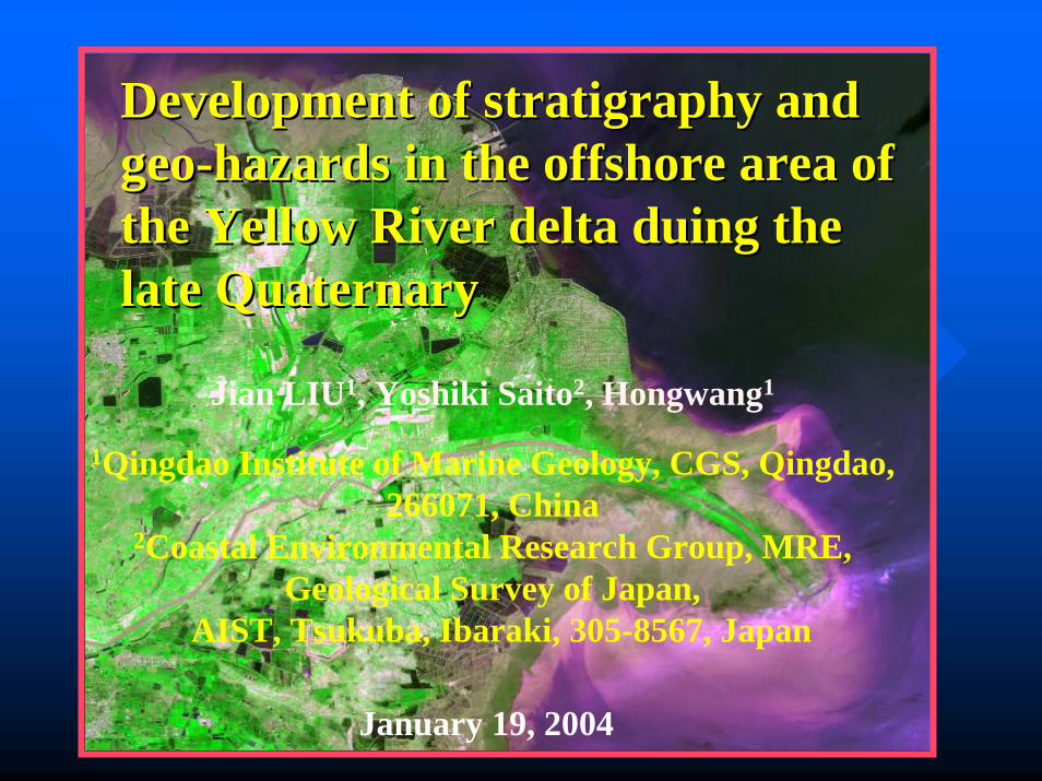
Development of Development of stratigraphystratigraphy and and geogeo--hazards in the offshore area of hazards in the offshore area of the Yellow River delta the Yellow River delta duingduing the the late Quaternarylate Quaternary
Jian LIU1, Yoshiki Saito2, Hongwang1
1Qingdao Institute of Marine Geology, CGS, Qingdao, 266071, China
2Coastal Environmental Research Group, MRE, Geological Survey of Japan,
AIST, Tsukuba, Ibaraki, 305-8567, Japan
January 19, 2004
OutlineOutlineIntroductionIntroduction
MethodsMethods
LateLate--Quaternary Quaternary stratigraphystratigraphy
GeoGeo--hazards in the hazards in the subaqueoussubaqueous YRDYRD
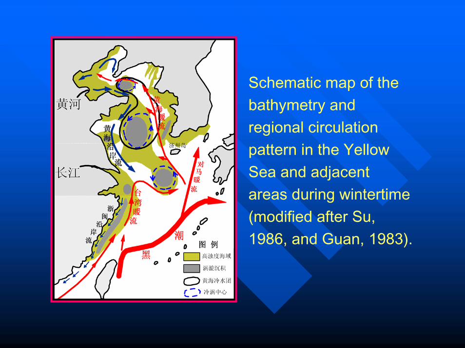
Schematic map of the bathymetry and regional circulation pattern in the Yellow Sea and adjacent areas during wintertime (modified after Su, 1986, and Guan, 1983).
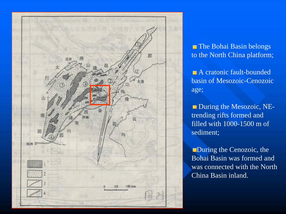
The Bohai Basin belongs to the North China platform;
A cratonic fault-bounded basin of Mesozoic-Cenozoic age;
During the Mesozoic, NE-trending rifts formed and filled with 1000-1500 m of sediment;
During the Cenozoic, the Bohai Basin was formed and was connected with the North China Basin inland.
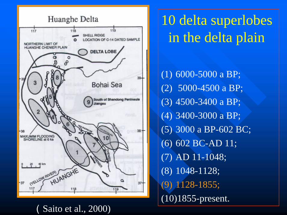
10 delta superlobesin the delta plain
(1) 6000-5000 a BP;(2) 5000-4500 a BP;(3) 4500-3400 a BP;(4) 3400-3000 a BP;(5) 3000 a BP-602 BC;(6) 602 BC-AD 11;(7) AD 11-1048;(8) 1048-1128;(9) 1128-1855;(10)1855-present.
(Saito et al., 2000)
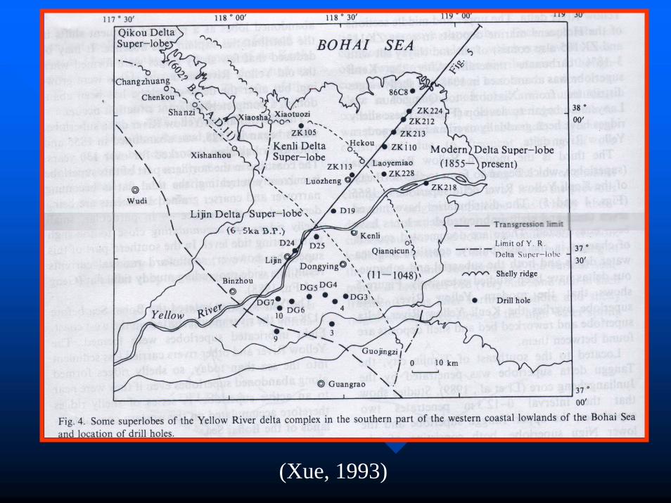
(Xue, 1993)
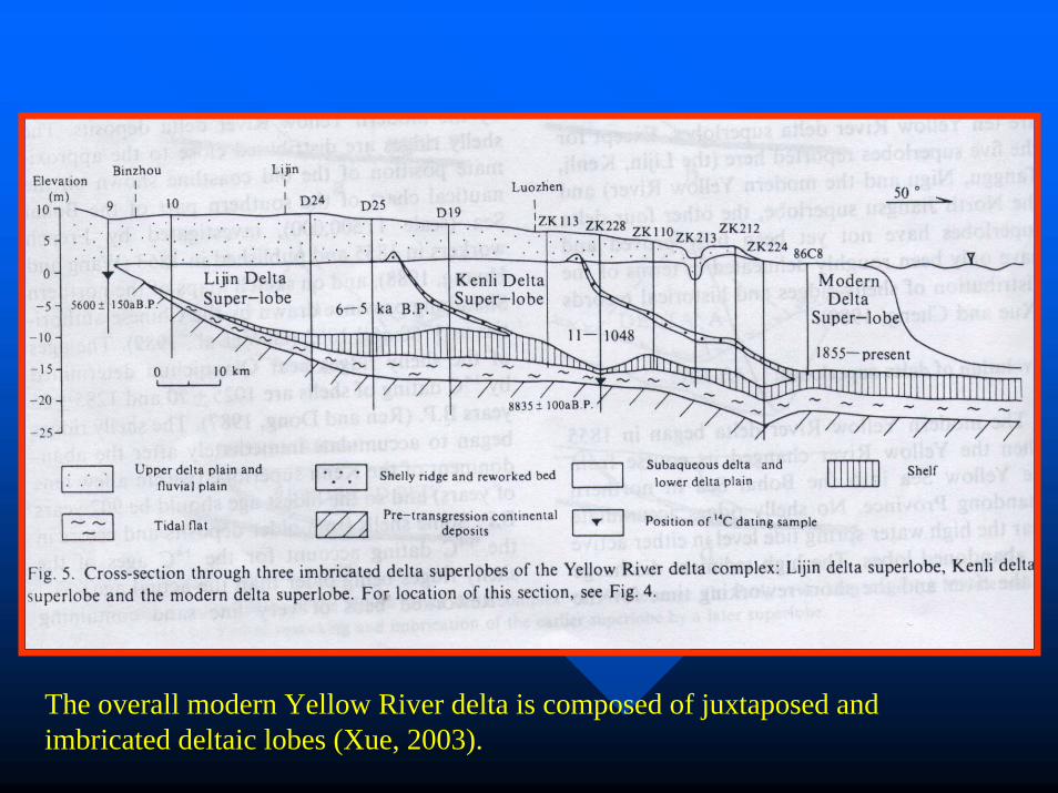
The overall modern Yellow River delta is composed of juxtaposed and imbricated deltaic lobes (Xue, 2003).
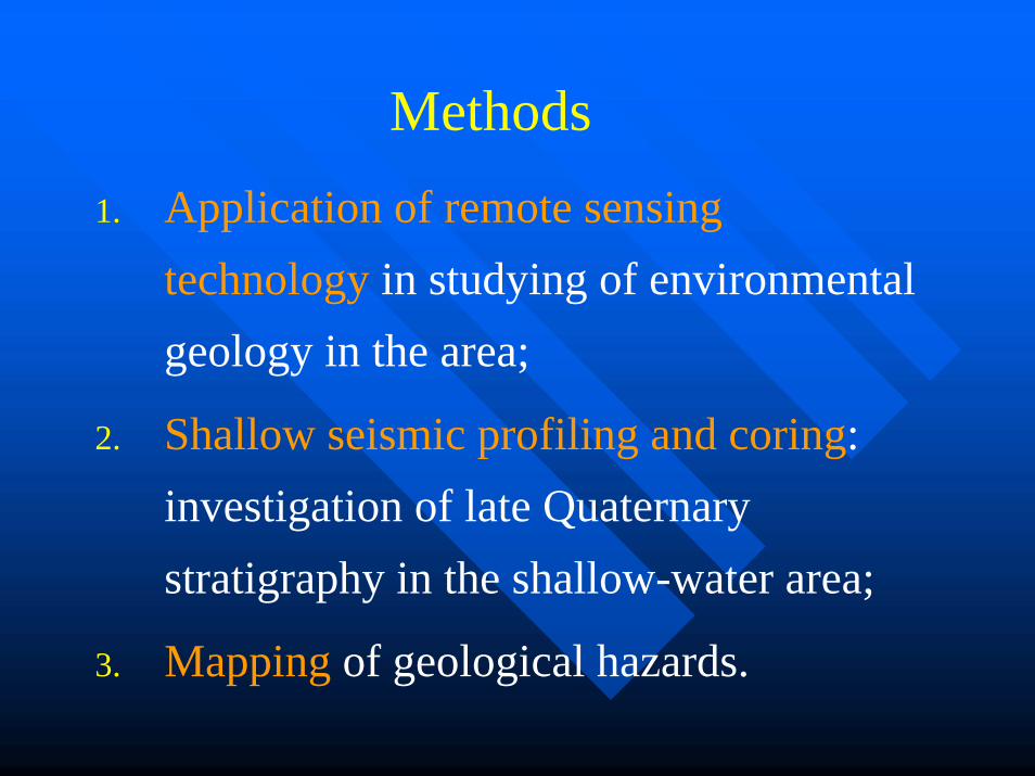
1. Application of remote sensing technology in studying of environmental geology in the area;
2. Shallow seismic profiling and coring: investigation of late Quaternary stratigraphy in the shallow-water area;
3. Mapping of geological hazards.
Methods
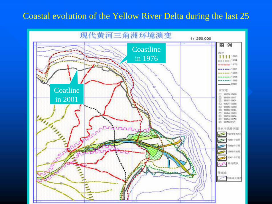
Coastal evolution of the Yellow River Delta during the last 25
Coastline in 1976
Coatlinein 2001
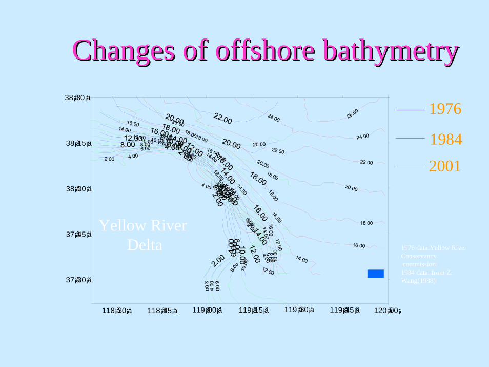
Changes of offshore bathymetryChanges of offshore bathymetry
118¡ã30¡ä 118¡ã45¡ä 119¡ã00¡ä 119¡ã15¡ä 119¡ã30¡ä 119¡ã45¡ä 120¡ã00¡ä
38¡ã30¡ä
38¡ã15¡ä
38¡ã00¡ä
37¡ã45¡ä
37¡ã30¡ä
1976
19842001
Yellow River Delta 1976 data:Yellow River
Conservancycommission
1984 data: from Z. Wang(1988)
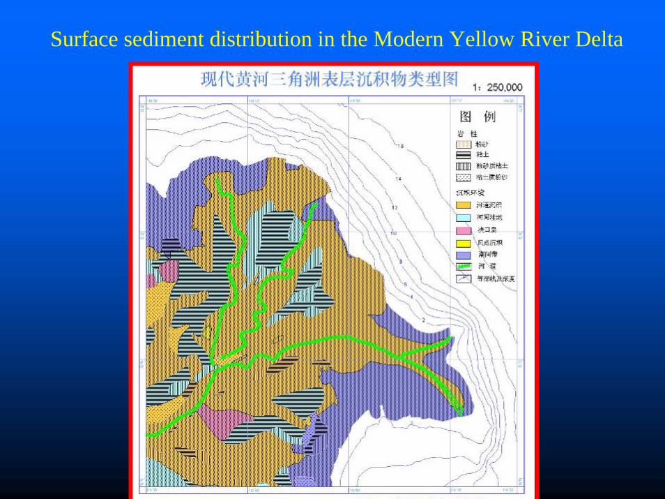
Surface sediment distribution in the Modern Yellow River Delta
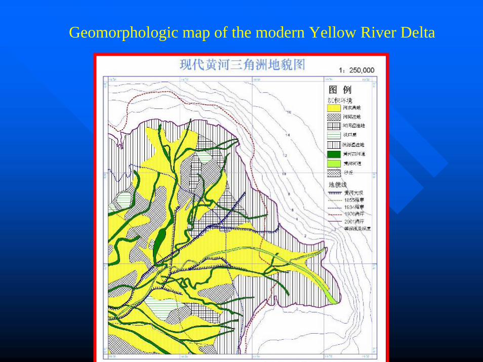
Geomorphologic map of the modern Yellow River Delta
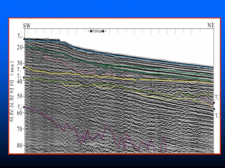
Investigation of late Quaternary Investigation of late Quaternary StratigraphicStratigraphic frameworkframework
One core as long as One core as long as 61 m 61 m was retrieved;was retrieved;
Seismic profiles of about Seismic profiles of about 700 km700 km were were measured.measured.
H1
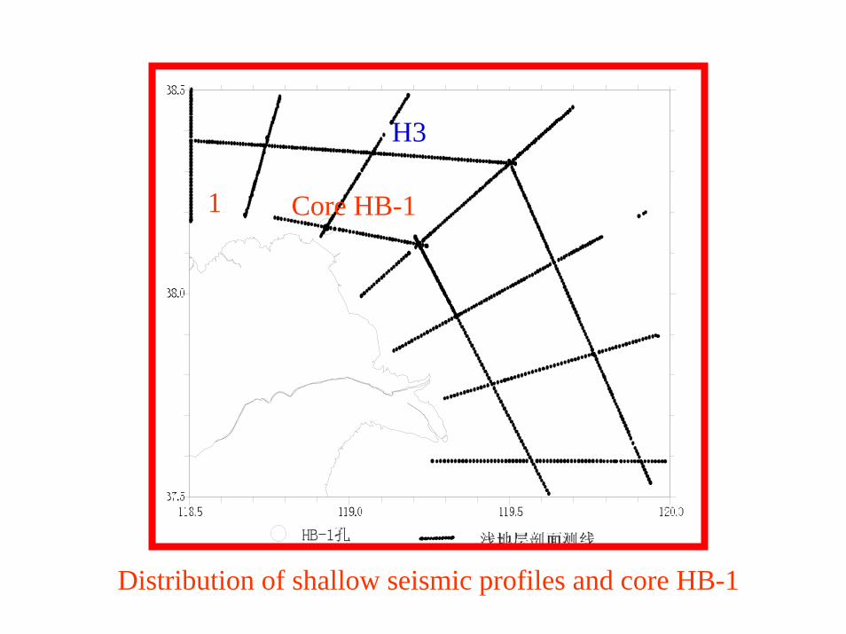
H3
Core HB-1
Distribution of shallow seismic profiles and core HB-1
Survey equipmentSurvey equipment
Vessels: Jiwenyu 4003 & Luheyu 2069Vessels: Jiwenyu 4003 & Luheyu 2069HighHigh--resolution seismic profiles were resolution seismic profiles were obtained using 300obtained using 300--500J CSP 1500 sparker, 500J CSP 1500 sparker, with vertical resolution of 0.5with vertical resolution of 0.5--1 m. 1 m. Penetration of 150 ms twoPenetration of 150 ms two--way travel timeway travel timeDevice measuring the offshore bathymetry: Device measuring the offshore bathymetry: SDHSDH--13D 13D
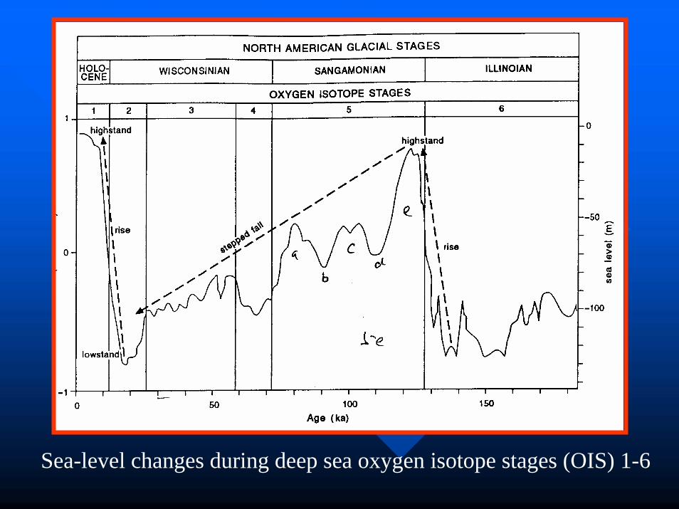
Sea-level changes during deep sea oxygen isotope stages (OIS) 1-6
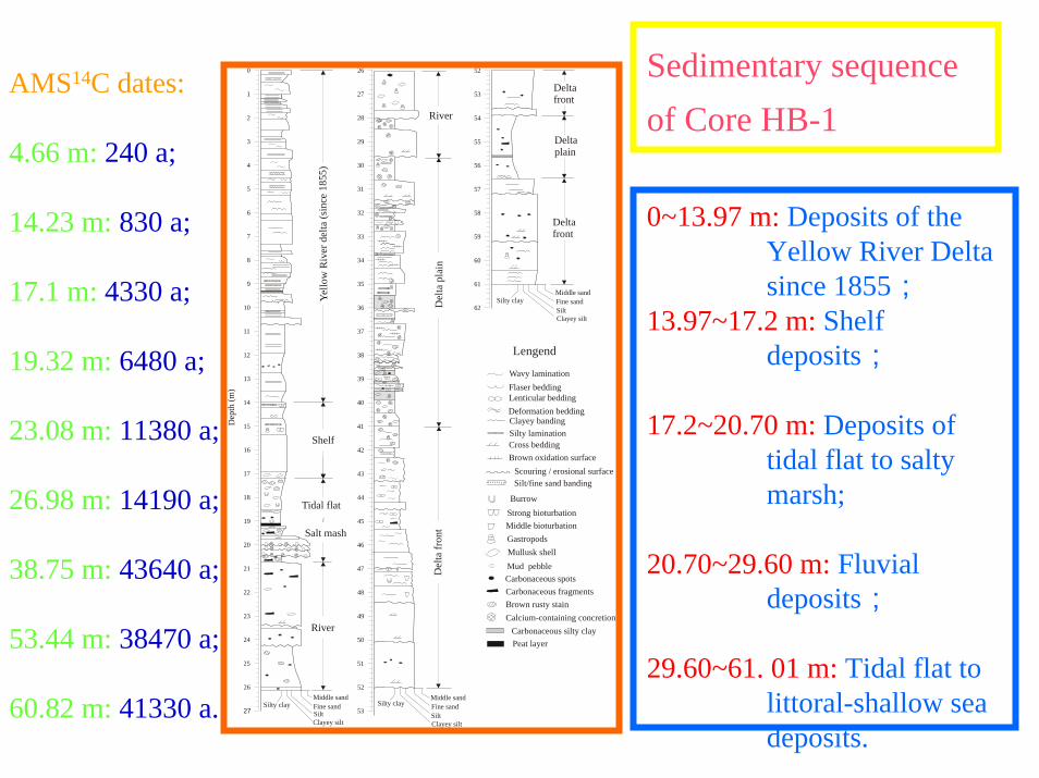
Sedimentary sequence of Core HB-1
0~13.97 m: Deposits of the Yellow River Delta since 1855;
13.97~17.2 m: Shelf deposits;
17.2~20.70 m: Deposits of tidal flat to salty marsh;
20.70~29.60 m: Fluvial deposits;
29.60~61. 01 m: Tidal flat to littoral-shallow sea deposits.
52
53
54
55
56
57
58
59
60
61
62
26
27
28
29
30
31
32
33
34
35
36
37
38
39
40
41
42
43
44
45
46
47
48
49
50
51
52
53
0
1
2
3
4
5
6
7
8
9
10
11
12
13
14
15
16
17
18
19
20
21
22
23
24
25
26
27
Mud pebble
Yello
w R
iver
del
ta (s
ince
185
5)
Shelf
Tidal flat
Salt mash
River
Middle sandFine sandSiltClayey silt
Silty clayMiddle sandFine sandSiltClayey silt
Silty clay
River
Del
ta p
lain
Del
ta f r
ont
Deltafront
Delta plain
Middle sandFine sandSiltClayey silt
Silty clay
Lengend
Wavy lamination
Cross bedding
Scouring / erosional surfaceBrown oxidation surface
Peat layer
Mullusk shell
Deformation beddingClayey banding Silty lamination
Lenticular bedding
Silt/fine sand banding
Carbonaceous fragments
Strong bioturbationMiddle bioturbation
Calcium-containing concretionCarbonaceous silty clay
Brown rusty stain
Carbonaceous spots
Burrow
Gastropods
Flaser bedding
Dep
th (m
)
Deltafront
AMS14C dates:
4.66 m: 240 a;
14.23 m: 830 a;
17.1 m: 4330 a;
19.32 m: 6480 a;
23.08 m: 11380 a;
26.98 m: 14190 a;
38.75 m: 43640 a;
53.44 m: 38470 a;
60.82 m: 41330 a.
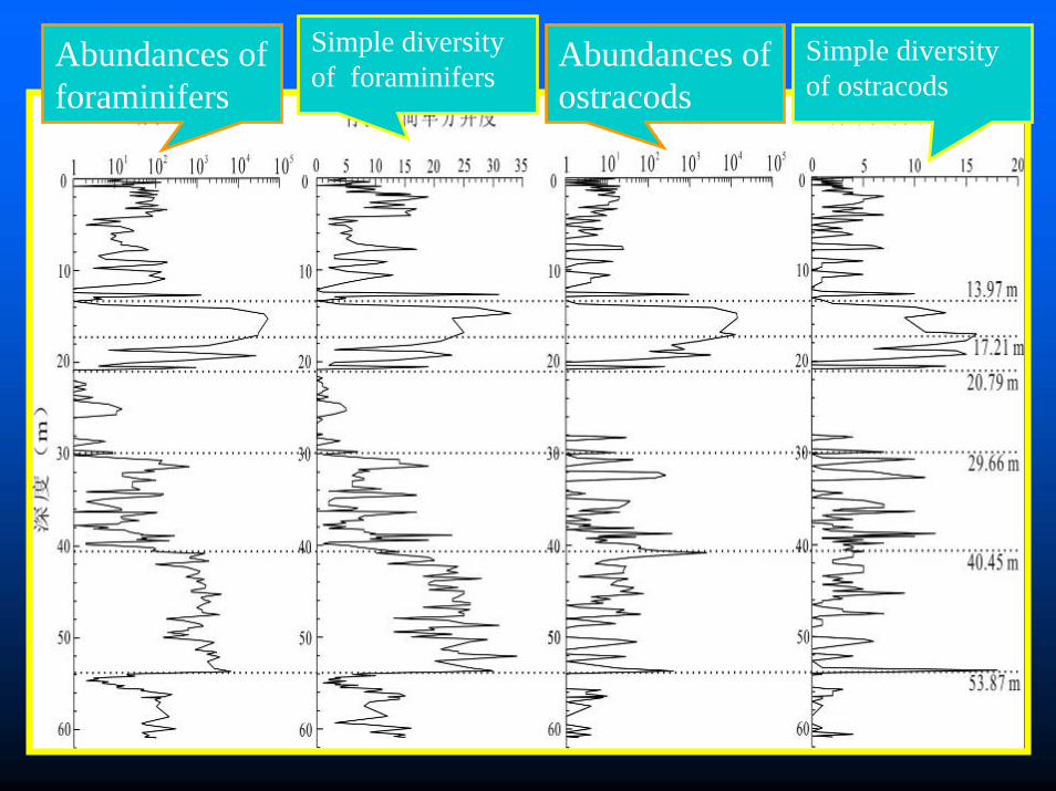
Abundances of foraminifers
Abundances of ostracods
Simple diversity of foraminifers
Simple diversity of ostracods
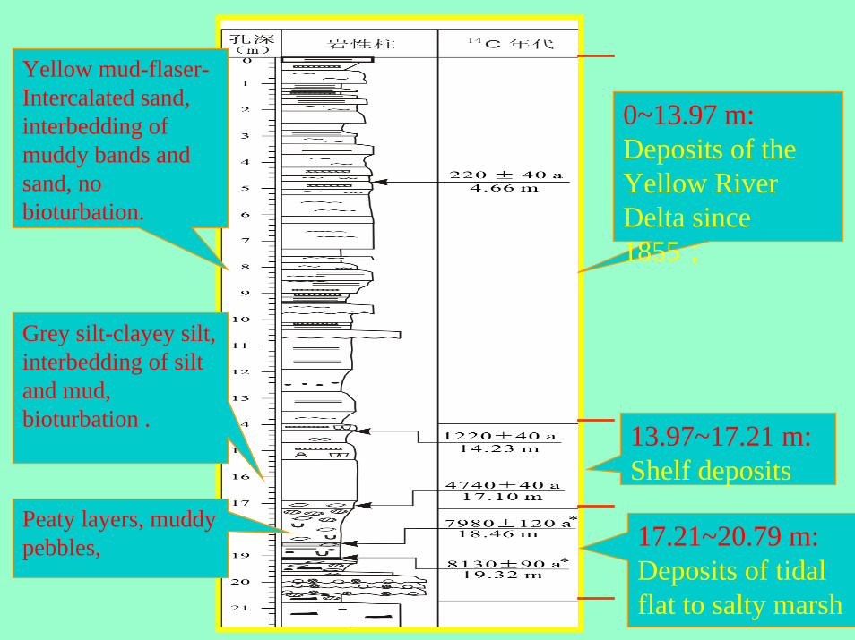
0~13.97 m:Deposits of the Yellow River Delta since 1855;
13.97~17.21 m:Shelf deposits
17.21~20.79 m:Deposits of tidal flat to salty marsh
Yellow mud-flaser-Intercalated sand, interbedding of muddy bands and sand, no bioturbation.
Grey silt-clayey silt, interbedding of silt and mud, bioturbation .
Peaty layers, muddy pebbles,
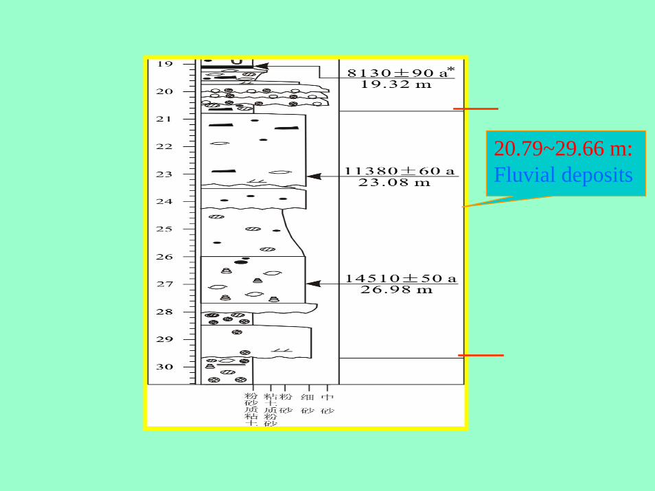
20.79~29.66 m:Fluvial deposits
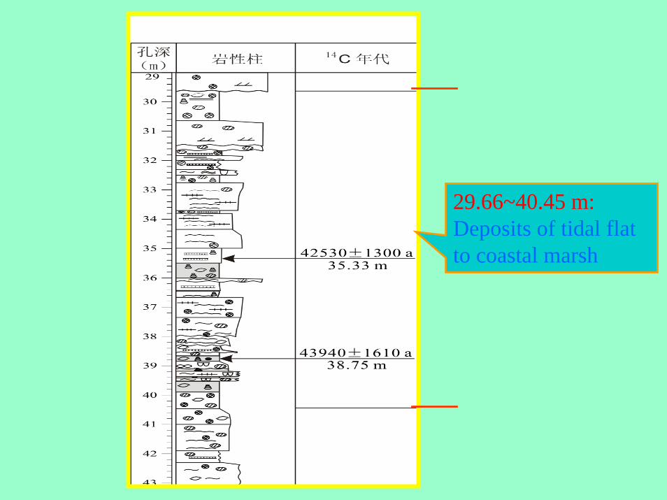
29.66~40.45 m:Deposits of tidal flat to coastal marsh
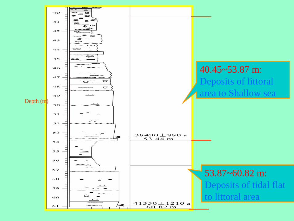
40.45~53.87 m:Deposits of littoral area to Shallow sea
53.87~60.82 m:Deposits of tidal flat to littoral area
Depth (m)

Abunndance of euryhaline and brackish water
species
Percentage of euryhaline and brackish water
species
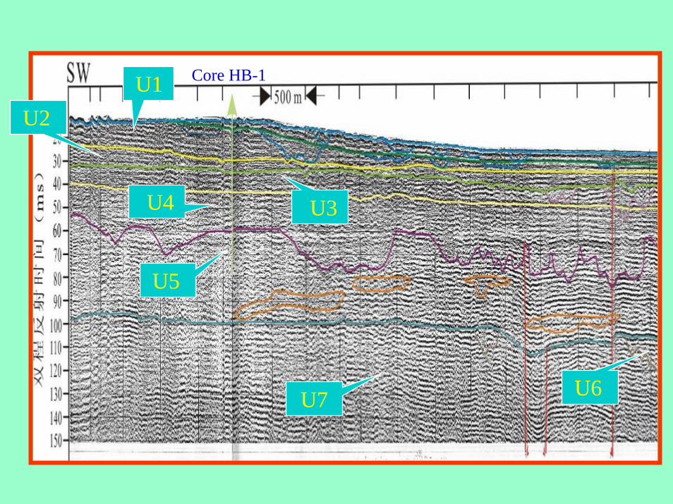
U1U2
U3U4
U5
U6U7
Core HB-1
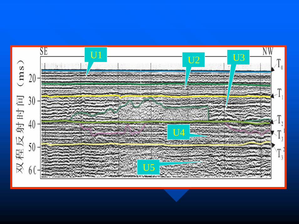
U1 U2 U3
U4
U5
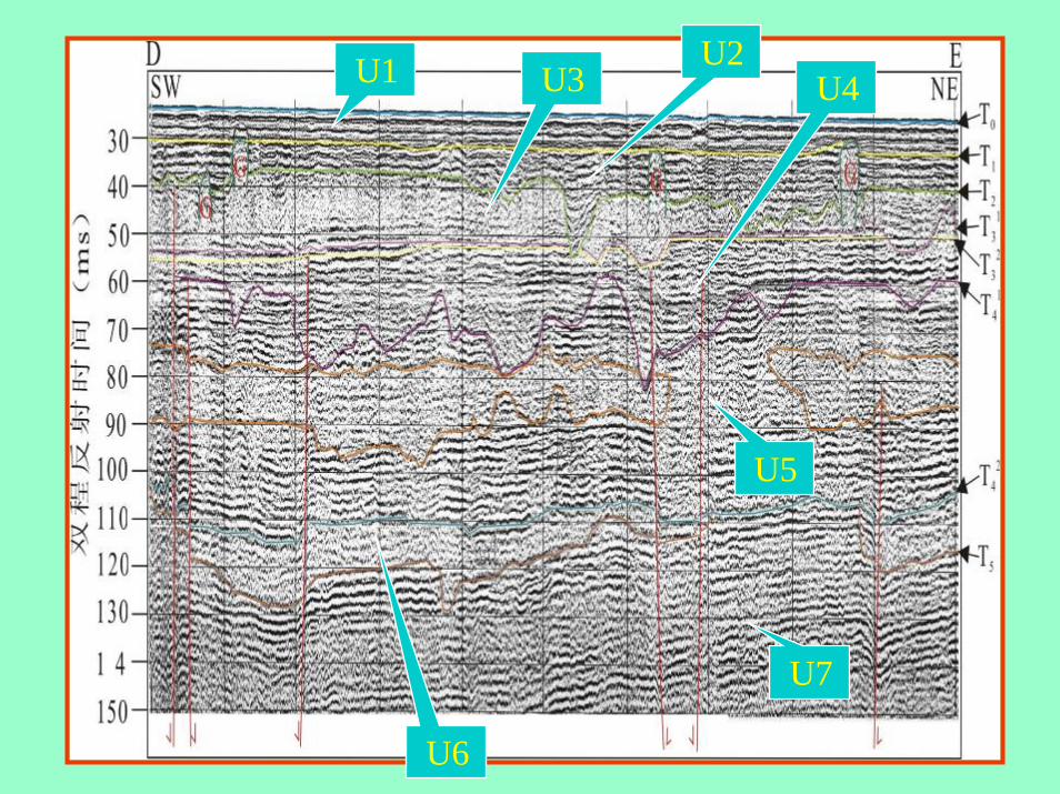
U1 U1U2U3 U4
U5
U6
U7
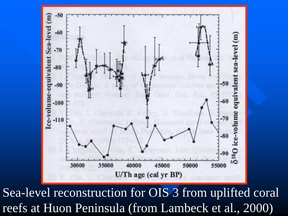
Sea-level reconstruction for OIS 3 from uplifted coral reefs at Huon Peninsula (from Lambeck et al., 2000)
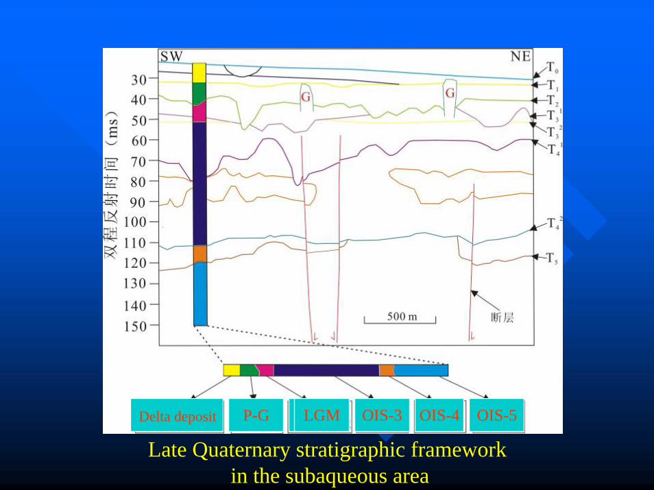
Delta deposit P-G LGM OIS-3 OIS-4 OIS-5
Late Quaternary stratigraphic framework in the subaqueous area
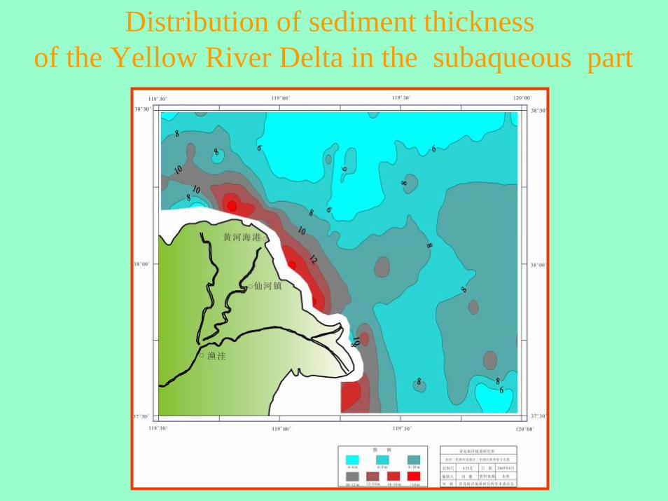
Distribution of sediment thickness of the Yellow River Delta in the subaqueous part
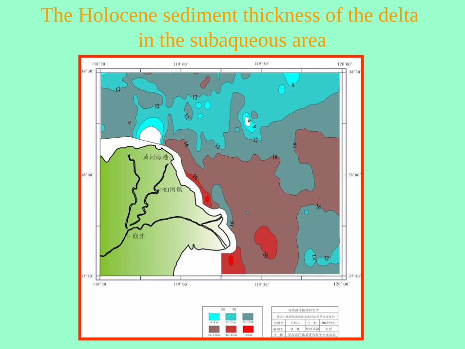
The Holocene sediment thickness of the delta in the subaqueous area
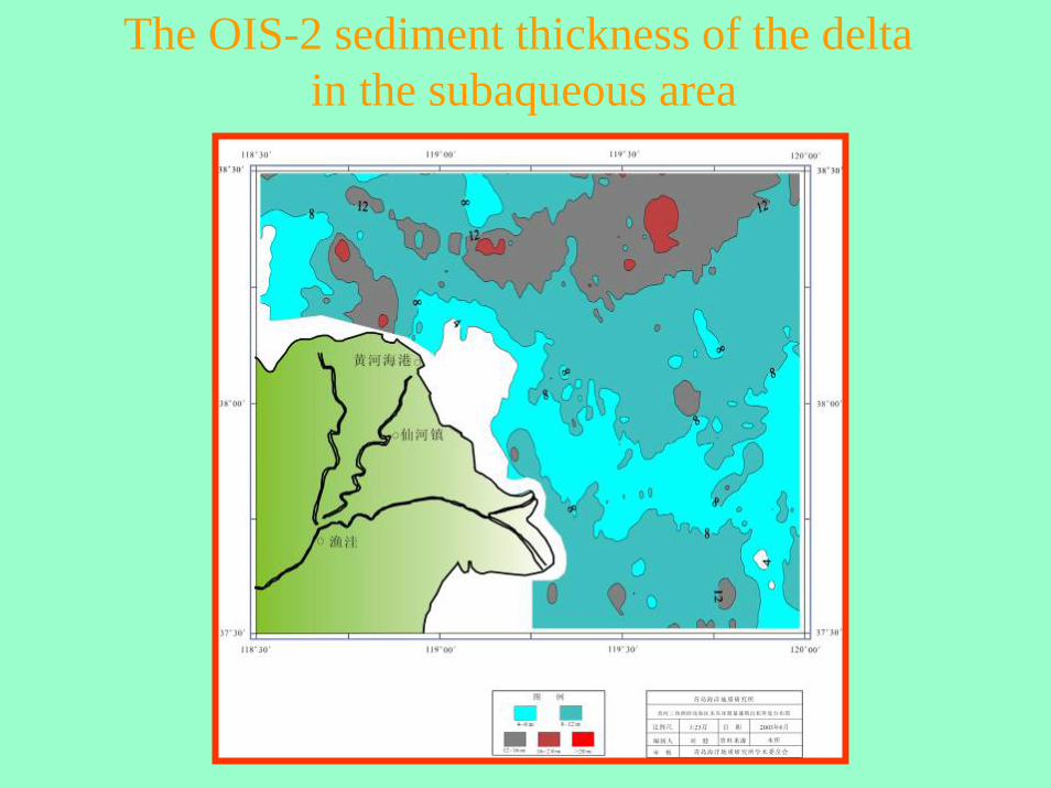
The OIS-2 sediment thickness of the delta in the subaqueous area
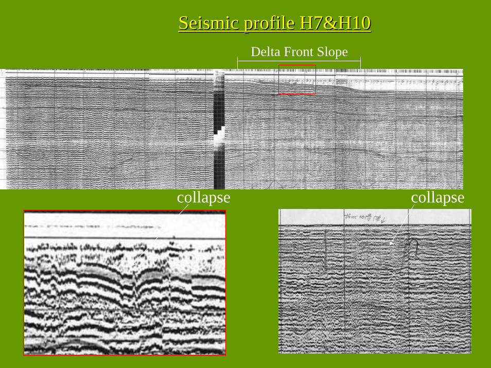
Seismic profile H7&H10Seismic profile H7&H10
collapsecollapse
Delta Front Slope
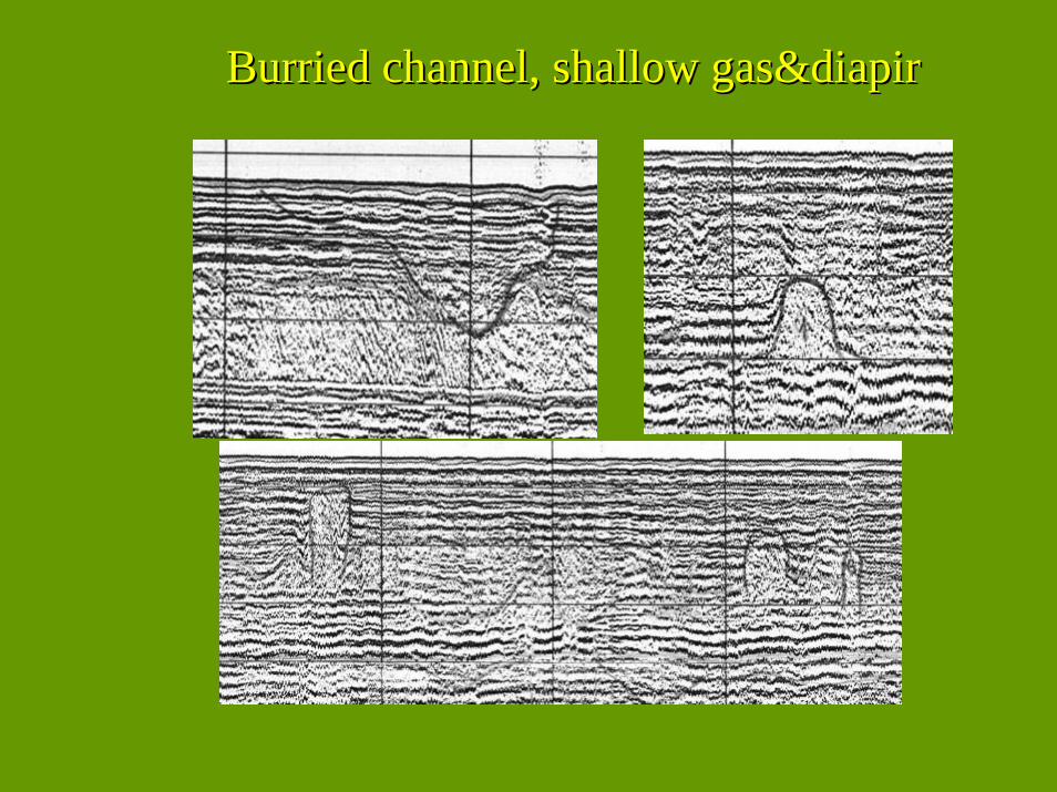
BurriedBurried channel, shallow channel, shallow gas&diapirgas&diapir
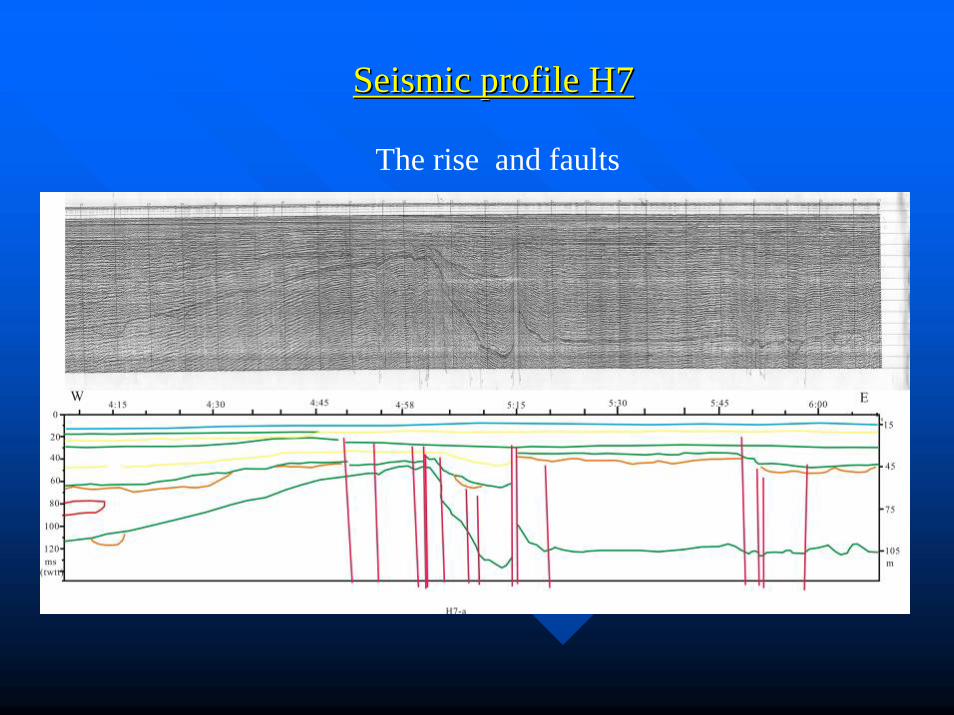
Seismic profile H7Seismic profile H7
The rise and faults
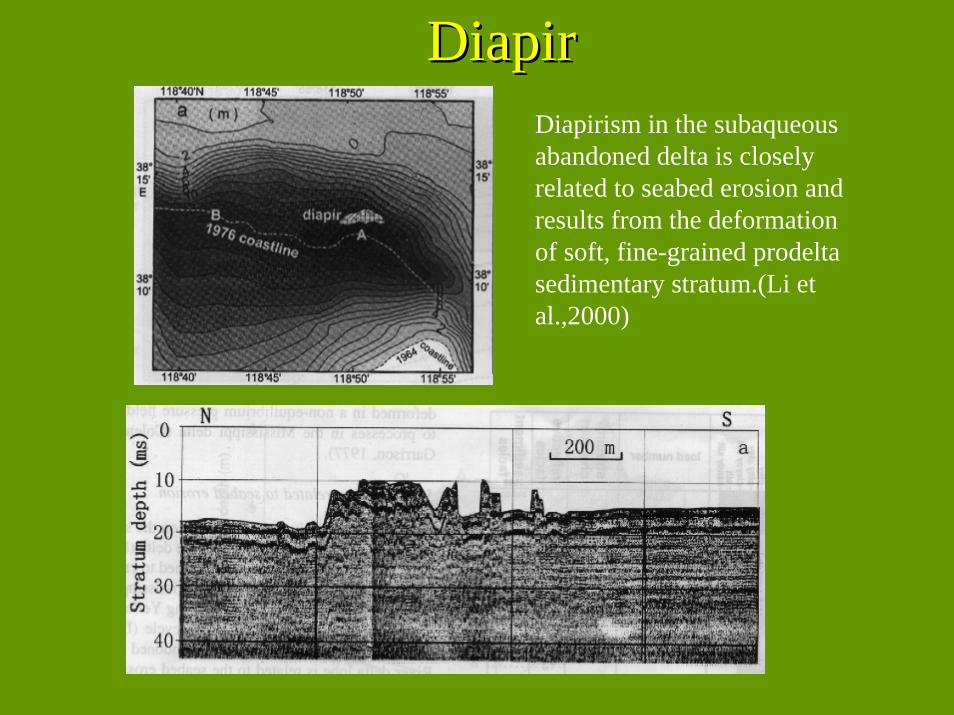
DiapirDiapirDiapirism in the subaqueousabandoned delta is closely related to seabed erosion and results from the deformation of soft, fine-grained prodeltasedimentary stratum.(Li et al.,2000)
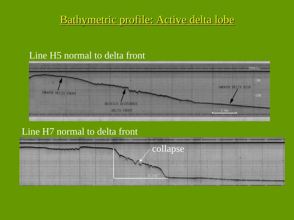
Bathymetric profile: Active delta lobeBathymetric profile: Active delta lobe
Line H5 normal to delta front
Line H7 normal to delta front
collapse
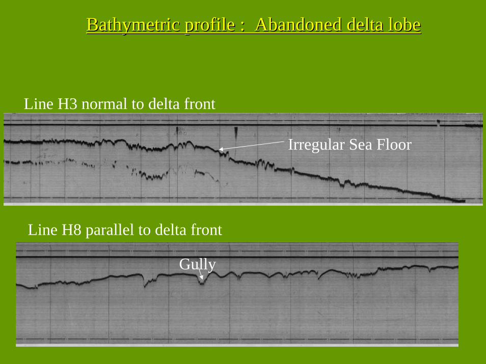
Bathymetric profile : Abandoned delta lobeBathymetric profile : Abandoned delta lobe
Line H3 normal to delta front
Line H8 parallel to delta front
Irregular Sea Floor
Gully
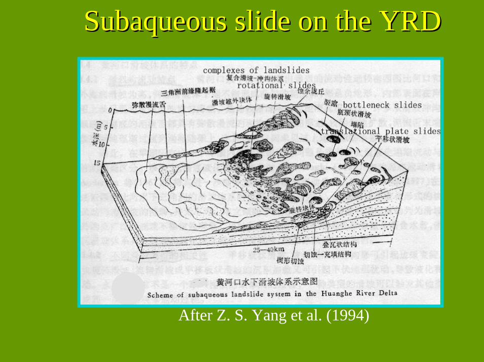
SubaqueousSubaqueous slide on the YRDslide on the YRD
After Z. S. Yang et al. (1994)
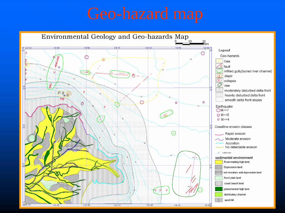
Geo-hazard map
Conclusion on the geo-hazardsFour types of coastline erosion were distinguished, including: rapid erosion, moderate erosion, no detectable erosion, and accretion.
geo-hazards were found: coast erosion, diapir, shallow gas, seabed stability, faults, seabed morphology.
The resultant map of geo-environment and geo-hazards presents the coastline change and distribution of geo-hazards in the Yellow River Delta
The rise outside of the modern river mouth is a new evidence for the seabed mass-movement

Thank You!