Embed Size (px)
Citation preview
PACIFIC ISLANDS APPLIED GEOSCIENCE COMMISSION
SUPPORTING DISASTER RISK REDUCTION IN PACIFIC OVERSEAS COUNTRIES AND TERRITORIES (OCTS)
Technical Scoping Mission, French Polynesia 24 September to 2 October 2009
SOPAC Trip Report 494
Jens Kruger Ocean & Islands Programme, SOPAC
ACKNOWLEDGEMENTS Sincere gratitude is extended to the State and Country of French Polynesia who generously gave their time, ensured all arrangements ran smoothly, provided transport and ensured that the SOPAC team was able to meet with a number of key stakeholders. Special thanks go to Bruno PEAUCELLIER and Steven RAY, International Relations of the President's office, as well as Alain LO-YAT of the Pearl Culture Service. SOPAC also wishes to acknowledge the services provided by Roy Benyon and the Translation and Interpretation Section of the Secretariat of Pacific Communities. INTRODUCTION This trip report provides details of a technical scoping mission to French Polynesia under the “Supporting Disaster Risk Reduction in Pacific OCTs Project” funded through the ninth Development Fund (EDF9); where OCTs are the Pacific Overseas Countries and Territories, namely French Polynesia, New Caledonia, Pitcairn Islands and Wallis and Futuna. The overall objective of this four year Project is to contribute to the reduction of the vulnerability of Pacific OCTs to losses and impacts from natural and anthropogenic disasters, and climate and weather extremes. The specific objective of the project is to mainstream disaster risk reduction principles into sustainable natural resource management, good governance and national processes. It will also identify and where possible address changing environmental use patterns which contribute to the exposure and level of risk for those communities. The Project will be delivered in-country using SOPAC's (Pacific Islands Applied Geoscience Commission) existing technical capacity and tools spanning each technical programme: • Community Lifelines (water, sanitation, GIS/RS). • Community Risks (disaster risk management [DRM], disaster risk reduction [DRR]). • Ocean & Islands (ocean & coastal science, hydrodynamic modelling, geodetic survey,
hydrography).
[2]
[SOPAC Trip Report 494 – Kruger]
These technical capacities, tools and resources will be strategically deployed in cooperation with local authorities and the technical solutions developed will be combined with resource economics tools such as cost/benefit analysis to develop integrated approaches to DRR which are technically, financially and socially appropriate. This visit represented the first face to face meeting held between SOPAC and the State and country authorities as well as other relevant stakeholders of French Polynesia. The objective of the trip was twofold. Firstly, to introduce the Project to French Polynesia, including familiarising stakeholders with SOPAC's organisational structure, regional function and services and support offered under the present Project. Secondly, a range of group meetings and one-on-one meetings were held to discuss potential directions and priorities for the DRR Project in French Polynesia. NATURAL HAZARD MITIGATION IN FRENCH POLYNESIA In French Polynesia, the State is responsible for civil defense, public order, and crisis management, and thus carries out any functions pertaining to disaster management. The Country is responsible for the urban development regulations including disaster risk reduction, which is implemented by the urban planning department (SAU). Following the impact of cyclone Alan on the Society Islands in 1998, French Polynesia requested the study and mapping of natural hazards in all the island groups (ARAI Programme). This received funding of EUR 3.7 m and was implemented by BRGM from 2002-2006 covering tsunamis, floods, landslides, ocean swell waves and earthquakes. Given the findings of the ARAI, the Country decided to implement plans to reduce the risk to the identified hazards (PPR). The PPR is a document produced by the country regulating land-use based on natural hazards to which they are submitted, and comprises the following document for each of the territories:
• Introductory report containing the analysis of hazards taken into account and a study of their impact on people and property, present and future. It also highlights the principles of developing the PPR.
• Map atlas of e.g. historical events and hazards, and including zoning maps on a scale from 1: 10 000 and 1: 25 000, which specifies the areas controlled by the PPR.
• Regulation that specifies the rules for each zone. • Methodology.
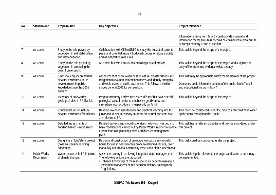
The above are most comprehensive and detailed in the high islands, especially urban Tahiti, and less so in the low-lying and less populated region of the Tuamotu archipelago, where development is restricted primarily through coastal setback rules. SYNTHESIS OF PROJECT INTERVENTION REQUESTS Stakeholders submitted a total of 14 separate project intervention proposals in writing; while a further 13 requests were received verbally during group and one-on-one discussions with stakeholders. Table 1 below presents a synthesis of all 27 tasks, establishing cross-links between the individual tasks, and highlighting synergies that provide the basis for the development of a country implementation plan under the Project. A summary of the discussions held and stakeholders met during the mission is presented in Appendix B. The written proposals that were received are included in Appendix C.
[3]
[SOPAC Trip Report 494 – Kruger]
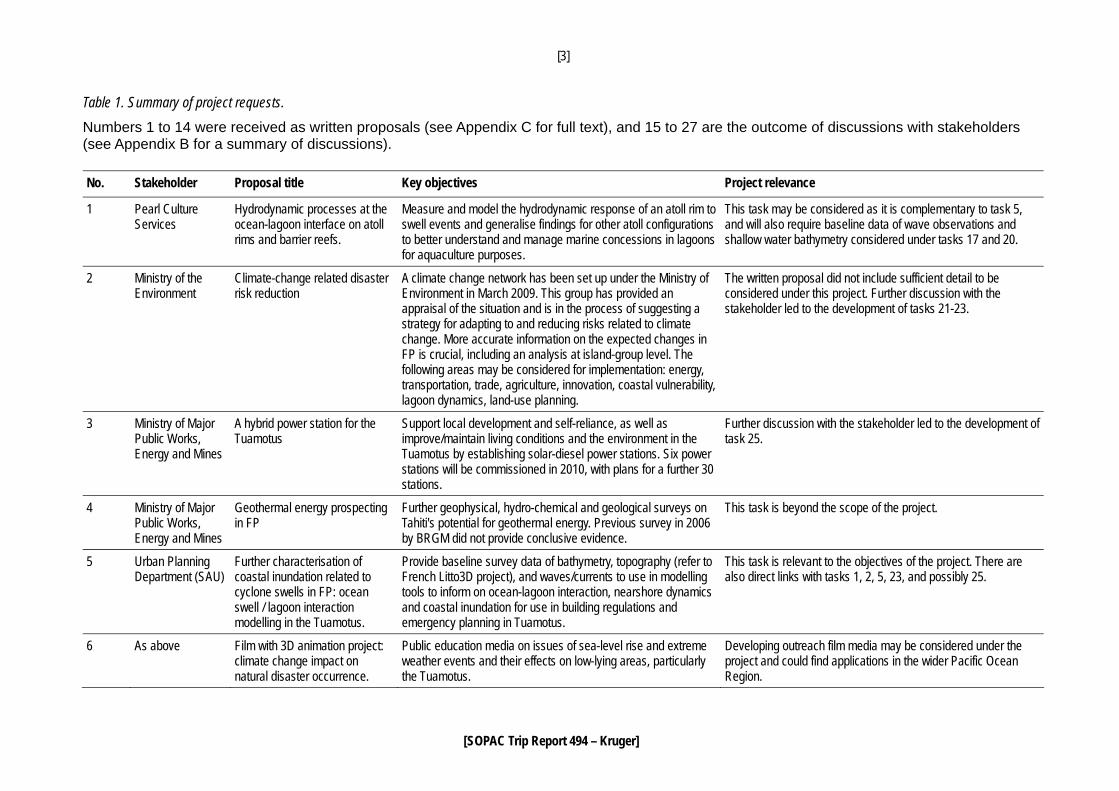
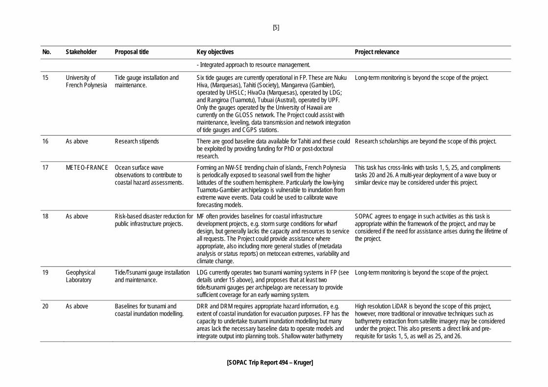
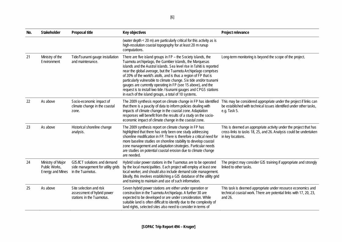
Table 1. Summary of project requests. Numbers 1 to 14 were received as written proposals (see Appendix C for full text), and 15 to 27 are the outcome of discussions with stakeholders (see Appendix B for a summary of discussions). No. Stakeholder Proposal title Key objectives Project relevance
1 Pearl Culture Services
Hydrodynamic processes at the ocean-lagoon interface on atoll rims and barrier reefs.
Measure and model the hydrodynamic response of an atoll rim to swell events and generalise findings for other atoll configurations to better understand and manage marine concessions in lagoons for aquaculture purposes.
This task may be considered as it is complementary to task 5, and will also require baseline data of wave observations and shallow water bathymetry considered under tasks 17 and 20.
2 Ministry of the Environment
Climate-change related disaster risk reduction
A climate change network has been set up under the Ministry of Environment in March 2009. This group has provided an appraisal of the situation and is in the process of suggesting a strategy for adapting to and reducing risks related to climate change. More accurate information on the expected changes in FP is crucial, including an analysis at island-group level. The following areas may be considered for implementation: energy, transportation, trade, agriculture, innovation, coastal vulnerability, lagoon dynamics, land-use planning.
The written proposal did not include sufficient detail to be considered under this project. Further discussion with the stakeholder led to the development of tasks 21-23.
3 Ministry of Major Public Works, Energy and Mines
A hybrid power station for the Tuamotus
Support local development and self-reliance, as well as improve/maintain living conditions and the environment in the Tuamotus by establishing solar-diesel power stations. Six power stations will be commissioned in 2010, with plans for a further 30 stations.
Further discussion with the stakeholder led to the development of task 25.
4 Ministry of Major Public Works, Energy and Mines
Geothermal energy prospecting in FP
Further geophysical, hydro-chemical and geological surveys on Tahiti's potential for geothermal energy. Previous survey in 2006 by BRGM did not provide conclusive evidence.
This task is beyond the scope of the project.
5 Urban Planning Department (SAU)
Further characterisation of coastal inundation related to cyclone swells in FP: ocean swell / lagoon interaction modelling in the Tuamotus.
Provide baseline survey data of bathymetry, topography (refer to French Litto3D project), and waves/currents to use in modelling tools to inform on ocean-lagoon interaction, nearshore dynamics and coastal inundation for use in building regulations and emergency planning in Tuamotus.
This task is relevant to the objectives of the project. There are also direct links with tasks 1, 2, 5, 23, and possibly 25.
6 As above Film with 3D animation project: climate change impact on natural disaster occurrence.
Public education media on issues of sea-level rise and extreme weather events and their effects on low-lying areas, particularly the Tuamotus.
Developing outreach film media may be considered under the project and could find applications in the wider Pacific Ocean Region.
[4]
[SOPAC Trip Report 494 – Kruger]
No. Stakeholder Proposal title Key objectives Project relevance
Information arising from Task 5 could provide material and information for the film. Task 9 could be considered a prerequisite or complementary action to the film.
7 As above Study to the role played by vegetation in soil stabilisation and destabilisation.
Collaboration with CEMAGREF to study the impact of currents pests and potential future introduced species on slope stability and as adaptation measures.
This task is beyond the scope of the project.
8 As above Study on the role played by vegetation in protecting the coast from erosion.
As above but with a focus on controlling coastal erosion.
This task is beyond the scope of the project and a significant body of literature and evidence exists already.
9 As above Statistical enquiry on natural disaster awareness in FP, developments in public knowledge since the 2006 enquiry.
Assessment of public awareness of natural disaster issues and mitigation to evaluate information needs and identify strengths and weaknesses of public awareness. This follows a similar survey done in 2006 for comparison.
This task may be appropriate within the framework of the project. Outcomes could inform the content of the public film in Task 6 and educational kits as in Task 11.
10 As above Inventory of noteworthy geological sites in FP (Tahiti).
Prepare inventory and visitor's maps of sites that have special geological value in order to emphasise geodiversity and strengthen local eco-tourism, especially on Tahiti.
This task is beyond the scope of the project.
11 As above Educational kits on natural disaster awareness for schools.
Develop low-cost, user-friendly and practical teaching aids for junior and senior secondary students on natural disasters that are relevant to FP.
This could be considered under the project, and could have wider applications throughout the Pacific.
12 As above Detailed assessments of flooding hazard – more rivers.
Detailed surveys and modelling of rivers following river bed and bank modifications carried out by Public Works in order to update current land-use planning codes and disaster management plans.
This task has a relevant objective and may be considered under this project.
13 As above Designing a “light” Bure project (possible seaside building adaptation).
Design and construction of prototype low-cost, easy-to-build house for use in coastal areas prone to natural disasters, given that a fully operational community evacuation plan is operational.
This task could be considered under the project.
14 Public Works Department
Water resources in FP in terms of climate change.
Assist the country in achieving integrated water management. The following actions are proposed: - Enhance knowledge of the resource so as better to manage it. - Implement management and decision-making/ training tools. - Regulations.
This task is highly relevant to the project and some actions may be implemented.
[5]
[SOPAC Trip Report 494 – Kruger]
No. Stakeholder Proposal title Key objectives Project relevance
- Integrated approach to resource management.
15 University of French Polynesia
Tide gauge installation and maintenance.
Six tide gauges are currently operational in FP. These are Nuku Hiva, (Marquesas), Tahiti (Society), Mangareva (Gambier), operated by UHSLC; HivaOa (Marquesas), operated by LDG; and Rangiroa (Tuamotu), Tubuai (Austral), operated by UPF. Only the gauges operated by the University of Hawaii are currently on the GLOSS network. The Project could assist with maintenance, leveling, data transmission and network integration of tide gauges and CGPS stations.
Long-term monitoring is beyond the scope of the project.
16 As above Research stipends There are good baseline data available for Tahiti and these could be exploited by providing funding for PhD or post-doctoral research.
Research scholarships are beyond the scope of this project.
17 METEO-FRANCE Ocean surface wave observations to contribute to coastal hazard assessments.
Forming an NW-SE trending chain of islands, French Polynesia is periodically exposed to seasonal swell from the higher latitudes of the southern hemisphere. Particularly the low-lying Tuamotu-Gambier archipelago is vulnerable to inundation from extreme wave events. Data could be used to calibrate wave forecasting models.
This task has cross-links with tasks 1, 5, 25, and compliments tasks 20 and 26. A multi-year deployment of a wave buoy or similar device may be considered under this project.
18 As above Risk-based disaster reduction for public infrastructure projects.
MF often provides baselines for coastal infrastructure development projects, e.g. storm surge conditions for wharf design, but generally lacks the capacity and resources to service all requests. The Project could provide assistance where appropriate, also including more general studies of (metadata analysis or status reports) on metocean extremes, variability and climate change.
SOPAC agrees to engage in such activities as this task is appropriate within the framework of the project, and may be considered if the need for assistance arises during the lifetime of the project.
19 Geophysical Laboratory
Tide/Tsunami gauge installation and maintenance.
LDG currently operates two tsunami warning systems in FP (see details under 15 above), and proposes that at least two tide/tsunami gauges per archipelago are necessary to provide sufficient coverage for an early warning system.
Long-term monitoring is beyond the scope of the project.
20 As above Baselines for tsunami and coastal inundation modelling.
DRR and DRM requires appropriate hazard information, e.g. extent of coastal inundation for evacuation purposes. FP has the capacity to undertake tsunami inundation modelling but many areas lack the necessary baseline data to operate models and integrate output into planning tools. Shallow water bathymetry
High resolution LiDAR is beyond the scope of this project, however, more traditional or innovative techniques such as bathymetry extraction from satellite imagery may be considered under the project. This also presents a direct link and pre-requisite for tasks 1, 5, as well as 25, and 26.
[6]
[SOPAC Trip Report 494 – Kruger]
No. Stakeholder Proposal title Key objectives Project relevance
(water depth < 20 m) are particularly critical for this activity as is high-resolution coastal topography for at least 20 m runup computations.
21 Ministry of the Environment
Tide/Tsunami gauge installation and maintenance.
There are five island groups in FP – the Society islands, the Tuamotu archipelago, the Gambier islands, the Marquesas islands and the Austral islands. Sea level rise in Tahiti is reported near the global average, but the Tuamotu Archipelago comprises of 20% of the world's atolls, and is thus a region of FP that is particularly vulnerable to climate change. Six tide and/or tsunami gauges are currently operating in FP (see 15 above), and the request is to install two tide / tsunami gauges and CPGS stations in each of the island groups, a total of 10 systems.
Long-term monitoring is beyond the scope of the project.
22 As above Socio-economic impact of climate change in the coastal zone.
The 2009 synthesis report on climate change in FP has identified that there is a paucity of data to inform policies dealing with impacts of climate change in the coastal zone. Adaptation responses will benefit from the results of a study on the socio-economic impact of climate change in the coastal zone.
This may be considered appropriate under the project if links can be established with technical issues identified under other tasks, e.g. Task 5.
23 As above Historical shoreline change analysis.
The 2009 synthesis report on climate change in FP has highlighted that there has only been one study addressing shoreline modification in FP. There is therefore a critical need for more baseline studies on shoreline stability to develop coastal zone management and adaptation strategies. Particular needs are studies on potential coastal erosion due to climate change are needed.
This is deemed an appropriate activity under the project that has cross-links to tasks 18, 25, and 26. Analysis could be undertaken in key locations.
24 Ministry of Major Public Works, Energy and Mines
GIS/ICT solutions and demand side management for utility grids in the Tuamotus.
Hybrid solar power stations in the Tuamotus are to be operated by the local municipalities. Each project will employ at least one local worker, and should also include demand side management. Ideally, this involves establishing a GIS database of the utility grid and training to maintain and use of such information.
The project may consider GIS training if appropriate and strongly linked to other tasks.
25 As above Site selection and risk assessment of hybrid power stations in the Tuamotus.
Seven hybrid power stations are either under operation or construction in the Tuamotu Archipelago. A further 30 are expected to be developed or are under consideration. While suitable land is often difficult to identify due to the complexity of land rights, selected sites also need to consider in terms of
This task is deemed appropriate under resource economics and technical coastal work. There are potential links with 17, 20, 23, and 26.

[7]
[SOPAC Trip Report 494 – Kruger]
No. Stakeholder Proposal title Key objectives Project relevance
weather extremes, coastal dynamics, climate change, and land-use planning and hazard zonation prior to development approval.
26 Ministry of Public Works, town planning and ground transportation.
Baselines for disaster risk reduction in the Tuamotus.
The level of baseline data and vulnerability assessments are not sufficient for detailed disaster risk zoning in the Tuamotus. Improving access to baseline data, i.e. bathymetry and topography, will greatly assist in the formulation of hazard zones and development planning in the Tuamotus.
Highly relevant task as it would form a pre-requisite or strongly link with tasks 1, 5, 14, 17, 20, and 25.
27 As above Economic impact analysis of an evacuation of the Tuamotu Archipelago.
If continued long enough or accelerated by further global warming, a future rise in sea level is a clear threat to FP, and the atoll communities of the Tuamotu Archipelago in particular. Atoll inhabitants may need to be evacuated to the other regions of FP and the economic impact of this needs to be considered.
This task may be complementary to 14, and 22, and could be considered in a key location rather than the Archipelago.
[8]
[SOPAC Trip Report 494 – Kruger]
PROPOSED COUNTRY IMPLEMENTATION PLAN The following is an outline of a country implementation plan proposal based on the outcomes of the scoping mission as summarised in Table 1. Any final work plans will be subject to approval by the French Polynesian Authorities as well as SOPAC, and must ultimately be guided by the overall objectives of the Project, as agreed with the European Union. Geographic Location There are five island groups in French Polynesia – the Society Islands, the Tuamotu Archipelago, the Gambier Islands, the Marquesas Islands and the Austral Islands. The majority of tasks listed in Table 1 either specifically refer to the Tuamotu group or contain issues pertinent to predominantly coastal, low lying communities. It also appears that the high islands generally have better baseline data and more detailed and appropriate PPRs as they have been the focus of more in-depth risk studies. Additional DDR and DRM tasks in the Tuamotu Archipelago could therefore be of particular benefit relative to other groups in FP, especially since the Tuamotus are also considered to be more at risk from a range of natural hazards that are believed to be exacerbated by climate change (e.g. coastal inundation and erosion due to ocean surface waves coupled with sea level rise) and resource use patterns. Thus concentrating the Project’s efforts in one or two key locations in this group could make significant contributions to an area where there is the greatest paucity of resources and data. Given the sound DRR arguments towards implementation of the Project in the Tuamotu Group, SOPAC has given considerable thought to the range of tasks presented in Table 1. Of these it is envisaged that approximately 55% (15) could be directly addressed by the Project if the target location was within the Tuamotu Group, and there are a further 15% (4) which are also likely candidates depending on resources. Using an integrated approach to address these tasks may ultimately mean only some 30% (8) of the tasks identified in Table 1, would not be addressed under this Project in the target location. SOPAC also recognises that the deployment of some of our survey equipment (e.g. shallow water multibeam echosounder system) can be a relatively rare opportunity and thus we will make every effort to maximise the data collected in terms of coverage and applicability not only to DRR but also diverse users such as the pearl industry, tourism, coastal fisheries management, environmental and ecological management, etc. Again, it is therefore proposed that one key atoll or key location in the Tuamotu Archipelago be selected as Project intervention site. Phase I – Development of Baselines Atolls have the largest ratios of coastline length to land area, making them coastal entities that are particularly vulnerable to the impacts of natural hazards and climate change and variability because they have relatively scarce resources (for example, water resources, construction materials and land), and limited and high-cost transportation options. Table 1 shows that stakeholders are particularly concerned about extreme ocean surface waves, coastal erosion, coastal inundation, perturbations of marine, coastal and island ecosystems, depleting freshwater resources, and the impacts of these on island infrastructure, the country’s economy and human safety. Uncertainties of these impacts are exacerbated by the fact that there is a relatively poor knowledge base on nearshore surface ocean wave climate, nearshore bathymetry, coastal topography, shoreline positions, and freshwater resources. The limited baseline data was repeatedly raised during stakeholder discussions and is also mentioned in written submissions as can be seen from Table 1. It is therefore proposed that the Project initially focus on addressing the paucity of baseline data as outlined above, alongside a historical analysis of major natural hazards that have affected the study area. Committing resources to fill these critical knowledge gaps will be an essential building block to undertake hazard mapping.
[9]
[SOPAC Trip Report 494 – Kruger]
Phase II – Hazard Mapping and Risk Mitigation The historical and baseline data collected under Phase I will be further analysed to assess the risks of natural hazards. This phase will also include consultations with various local government partners and the island community. The results will predominantly be in the form of maps showing vulnerable areas and their hazards. The hazards maps will form the basis of a formal assessment to identify interventions to reduce risks and improve resource management. Phase III – Promotion of Disaster Risk Reduction in the Tuamotu Archipelago The current PPR regulates any constructions in high risk zones, and ensures that new buildings do not exacerbate risk factors and are not vulnerable to natural disasters. Thus, the rules of the PPR are required for future construction or modifications to existing structures, but also serve as a tool for land use planning and management. As mentioned above, the PPR is currently implemented through coastal setback rules. After the completion of the above first two Phases, it is envisaged that the Project will be in a position to update the PPR and provide greater detail and scope for DRR and resource management for the particular intervention location(s). Furthermore, the site-specific outcomes may be applicable to other predominantly coastal, low lying communities in French Polynesia, and provide the Project with the tools to mainstream disaster risk reduction principles into sustainable natural resource management, good governance, and planning processes throughout the Tuamotu Archipelago.
[10]
[SOPAC Trip Report 494 – Kruger]
LIST OF ABBREVIATIONS ALADIN Operational regional numerical weather prediction model. Developed in an
international cooperation led by METEO-FRANCE. ARPEGE Action de recherché petite echelle grande echelle (numerical weather prediction
system supported by METEO-France and ECMWF) BRGM Bureau of Geological and Mining Research CGPS Continuous Global Positioning System CPD Civil Protection Department ECMWF European Centre for Medium Range Weather Forecasting EMD Energy and Mining Department GLOSS Global sea level observing system HC High Commission IRD Institute of Development Research LDG Geophysical Laboratory ME Ministry of Environment MUT Ministry of public works, town planning and ground transportation MF METEO-FRANCE NAPA National action plan for adaptation NMHS National meteorological and hydrological services NSF National science foundation PPR Natural hazard mitigation plan SRI International Relations Services UHSLC University of Hawaii Sea Level Centre UPF University of French Polynesia PTWC Pacific tsunami warning centre RSMC Regional specialised meteorological centre SAU Urban Planning Department VP Office of the Vice President
[11]
[SOPAC Trip Report 494 – Kruger]
APPENDIX A Summary of the Project Supporting Disaster Risk Reduction in Pacific OCTs
Total duration of the action 48 MONTHS
Objectives of the action <Overall objective>
The Overall Objective of the Action is to contribute to the reduction of the vulnerability of Pacific OCT communities of French Polynesia, New Caledonia, Pitcairn Islands and Wallis and Futuna to losses and impacts from natural and anthropogenic disasters and, climate and weather extremes.
<Specific objective>
To mainstream disaster risk reduction principles into sustainable natural resource management, good governance and national processes and change environmental use patterns which contribute to the exposure of those communities at risk.
Partner(s) Associate Partners in the action include:
New Caledonia: Direction des Affaires Sanitaires et Sociales de Nouvelle Caledonie DASS – New Caledonia (DASS); Direction des Affaires Vétérinaires, Alimentaires et Rurales (DAVAR); Agence de développement économique, New Caledonia (ADECAL); Agence Française de Développement (AfD); and Service de Mines et Energie
French Polynesia: SDR (Service du Développement Rural), Departement de L’environnement, Meteo France; IRD
Wallis and Futuna: IRD
Pitcairn: Office of the Commissioner for Pitcairn Island
Associate regional partners in the action include: WHO, SPC, ESR, UNESCO, Pacific Disaster Risk Management Partnership Network, Pacific Partnership Initiative on Sustainable Water Management
Target group(s)1 These will be the different administrations (in-country), and their respective departments, as well other agencies responsible for the work sectors related to specific activities under the project such as those agencies such as for water, disaster management, natural resource management, and environment.
Final beneficiaries2 The main and final beneficiary groups of this Project are the communities of participating Pacific OCTs.
Estimated results Development of sound environmental and vulnerability baselines using a range of assessment, mapping and analysis tools.
Identification of interventions to reduce risks and improve resource management and/or mitigate damage from natural disasters and existing poor resource management practises.
Development and implementation of appropriate alternative resource use solutions where these influence vulnerability, planning improvements and hazard risk mitigation activities.
Promotion of integrated approaches to these issues and enhancement of relevant enabling environments.
1 “Target groups” are the groups/entities who will be directly positively affected by the project at the Project Purpose level 2 “Final beneficiaries” are those who will benefit from the project in the long term at the level of the society or sector at large
[12]
[SOPAC Trip Report 494 – Kruger]
Main activities Area of natural hazards: • Assessment of geological factors. • Analysis of climate and weather related events.
Assessing increased exposure to hazards through unsustainable resource and environmental use patterns: • Coastal zone and vulnerability assessment and planning. • Geomorphologic and geological assessments. • Marine and freshwater pollution analysis and response. • Water resources monitoring, assessment and management. • Safety and security of drinking water supplies and wastewater
disposal. • Environmental baseline development and assessments.
[13]
[SOPAC Trip Report 494 – Kruger]
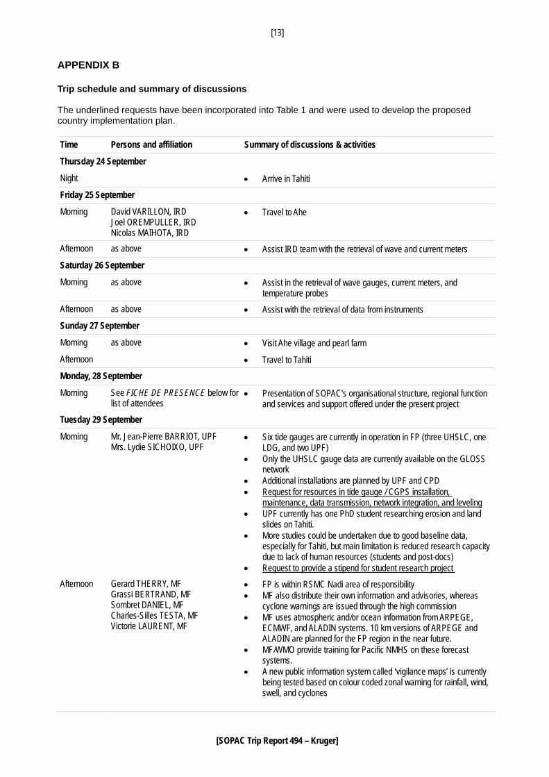
APPENDIX B Trip schedule and summary of discussions The underlined requests have been incorporated into Table 1 and were used to develop the proposed country implementation plan. Time Persons and affiliation Summary of discussions & activities
Thursday 24 September
Night • Arrive in Tahiti
Friday 25 September
Morning David VARILLON, IRD Joel OREMPULLER, IRD Nicolas MAIHOTA, IRD
• Travel to Ahe
Afternoon as above • Assist IRD team with the retrieval of wave and current meters
Saturday 26 September
Morning as above • Assist in the retrieval of wave gauges, current meters, and temperature probes
Afternoon as above • Assist with the retrieval of data from instruments
Sunday 27 September
Morning as above • Visit Ahe village and pearl farm
Afternoon • Travel to Tahiti
Monday, 28 September
Morning See FICHE DE PRESENCE below for list of attendees
• Presentation of SOPAC's organisational structure, regional function and services and support offered under the present project
Tuesday 29 September
Morning Mr. Jean-Pierre BARRIOT, UPF Mrs. Lydie SICHOIXO, UPF
• Six tide gauges are currently in operation in FP (three UHSLC, one LDG, and two UPF)
• Only the UHSLC gauge data are currently available on the GLOSS network
• Additional installations are planned by UPF and CPD • Request for resources in tide gauge / CGPS installation,
maintenance, data transmission, network integration, and leveling • UPF currently has one PhD student researching erosion and land
slides on Tahiti. • More studies could be undertaken due to good baseline data,
especially for Tahiti, but main limitation is reduced research capacity due to lack of human resources (students and post-docs)
• Request to provide a stipend for student research project Afternoon Gerard THERRY, MF
Grassi BERTRAND, MF Sombret DANIEL, MF Charles-Silles TESTA, MF Victorie LAURENT, MF
• FP is within RSMC Nadi area of responsibility • MF also distribute their own information and advisories, whereas
cyclone warnings are issued through the high commission • MF uses atmospheric and/or ocean information from ARPEGE,
ECMWF, and ALADIN systems. 10 km versions of ARPEGE and ALADIN are planned for the FP region in the near future.
• MF/WMO provide training for Pacific NMHS on these forecast systems.
• A new public information system called ‘vigilance maps’ is currently being tested based on colour coded zonal warning for rainfall, wind, swell, and cyclones
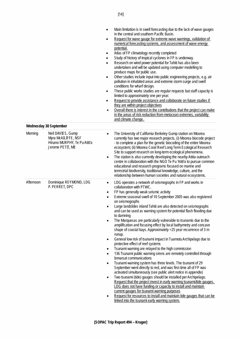
[14]
[SOPAC Trip Report 494 – Kruger]
• Main limitation is in swell forecasting due to the lack of wave gauges in the central and southern Pacific Basin.
• Request for wave gauge for extreme wave warnings, validation of numerical forecasting systems, and assessment of wave energy potential.
• Atlas of FP climatology recently completed • Study of history of tropical cyclones in FP is underway. • Research on wind power potential for Tahiti has also been
undertaken and will be updated using computer modelling to produce maps for public use.
• Other studies include input into public engineering projects, e.g. air pollution in inhabited areas and extreme storm surge and swell conditions for wharf design.
• These public works studies are regular requests but staff capacity is limited to approximately one per year.
• Request to provide assistance and collaborate on future studies if they are within project objectives
• Overall there is interest in the contributions that the project can make in the areas of risk reduction from metocean extremes, variability and climate change.
Wednesday 30 September
Morning Neil DAVIES, Gump Myra McAILIFFE, NSF Hinano MURPHY, Te Pu Atiti'a Jerome PETIT, ME
• The University of California Berkeley Gump station on Moorea currently has two major research projects, (i) Moorea biocode project - to complete a plan for the genetic biocoding of the entire Moorea ecosystem; (ii) Moorea Coral Reef Long Term Ecological Research Site to support research on long-term ecological phenomena.
• The station is also currently developing the nearby Atitia outreach centre in collaboration with the NGO Te Pu 'Atiti'a to pursue common educational and research programs focused on marine and terrestrial biodiversity, traditional knowledge, culture, and the relationship between human societies and natural ecosystems.
Afternoon Dominique REYMOND, LDG P. PERRET, DPC
• LDG operates a network of seismographs in FP and works in collaboration with PTWC.
• FP has generally weak seismic activity • Extreme seasonal swell of 10 September 2005 was also registered
on seismographs • Large landslides inland Tahiti are also detected on seismographs
and can be used as warning system for potential flash flooding due to damning
• The Marquesas are particularly vulnerable to tsunamis due to the amplification and focusing effect by local bathymetry and concave shape of coastal bays. Approximately <25 year recurrence of 3 m runup.
• General low risk of tsunami impact in Tuamotu Archipelago due to protective effect of reef systems
• Tsunami warning are relayed to the high commission • 136 Tsunami public warning sirens are remotely controlled through
Inmarsat communications • Tsunami warning system has three levels. The tsunami of 29
September went directly to red, and was first time all of FP was activated simultaneously (see public alert notice in appendix)
• Two tsunami (tide) gauges should be installed per Archipelago. Request that the project invest in early warning tsunami/tide gauges. LDG does not have funding or capacity to install and maintain current gauges for tsunami warning purposes
• Request for resources to install and maintain tide gauges that can be linked into the tsunami early warning system.
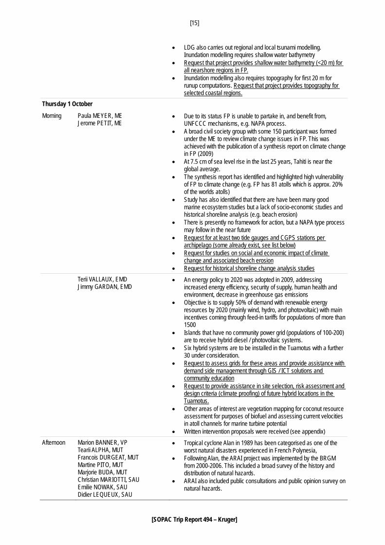
[15]
[SOPAC Trip Report 494 – Kruger]
• LDG also carries out regional and local tsunami modelling. Inundation modelling requires shallow water bathymetry
• Request that project provides shallow water bathymetry (<20 m) for all nearshore regions in FP.
• Inundation modelling also requires topography for first 20 m for runup computations. Request that project provides topography for selected coastal regions.
Thursday 1 October
Morning Paula MEYER, ME Jerome PETIT, ME
• Due to its status FP is unable to partake in, and benefit from, UNFCCC mechanisms, e.g. NAPA process.
• A broad civil society group with some 150 participant was formed under the ME to review climate change issues in FP. This was achieved with the publication of a synthesis report on climate change in FP (2009)
• At 7.5 cm of sea level rise in the last 25 years, Tahiti is near the global average.
• The synthesis report has identified and highlighted high vulnerability of FP to climate change (e.g. FP has 81 atolls which is approx. 20% of the worlds atolls)
• Study has also identified that there are have been many good marine ecosystem studies but a lack of socio-economic studies and historical shoreline analysis (e.g. beach erosion)
• There is presently no framework for action, but a NAPA type process may follow in the near future
• Request for at least two tide gauges and CGPS stations per archipelago (some already exist, see list below)
• Request for studies on social and economic impact of climate change and associated beach erosion
• Request for historical shoreline change analysis studies Terii VALLAUX, EMD
Jimmy GARDAN, EMD • An energy policy to 2020 was adopted in 2009, addressing
increased energy efficiency, security of supply, human health and environment, decrease in greenhouse gas emissions
• Objective is to supply 50% of demand with renewable energy resources by 2020 (mainly wind, hydro, and photovoltaic) with main incentives coming through feed-in tariffs for populations of more than 1500
• Islands that have no community power grid (populations of 100-200) are to receive hybrid diesel / photovoltaic systems.
• Six hybrid systems are to be installed in the Tuamotus with a further 30 under consideration.
• Request to assess grids for these areas and provide assistance with demand side management through GIS / ICT solutions and community education
• Request to provide assistance in site selection, risk assessment and design criteria (climate proofing) of future hybrid locations in the Tuamotus.
• Other areas of interest are vegetation mapping for coconut resource assessment for purposes of biofuel and assessing current velocities in atoll channels for marine turbine potential
• Written intervention proposals were received (see appendix) Afternoon Marion BANNER, VP
Tearii ALPHA, MUT Francois DURGEAT, MUT Martine PITO, MUT Marjorie BUDA, MUT Christian MARIOTTI, SAU Emilie NOWAK, SAU Didier LEQUEUX, SAU
• Tropical cyclone Alan in 1989 has been categorised as one of the worst natural disasters experienced in French Polynesia,
• Following Alan, the ARAI project was implemented by the BRGM from 2000-2006. This included a broad survey of the history and distribution of natural hazards.
• ARAI also included public consultations and public opinion survey on natural hazards.
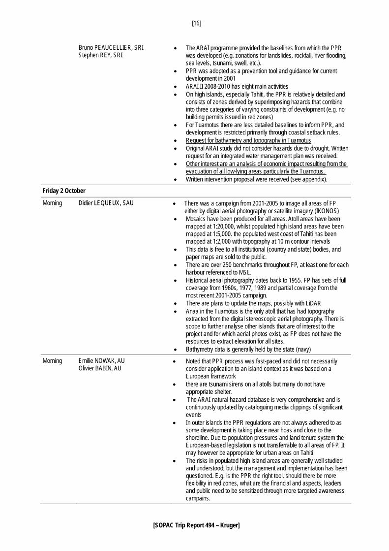
[16]
[SOPAC Trip Report 494 – Kruger]
Bruno PEAUCELLIER, SRI Stephen REY, SRI
• The ARAI programme provided the baselines from which the PPR was developed (e.g. zonations for landslides, rockfall, river flooding, sea levels, tsunami, swell, etc.).
• PPR was adopted as a prevention tool and guidance for current development in 2001
• ARAI II 2008-2010 has eight main activities • On high islands, especially Tahiti, the PPR is relatively detailed and
consists of zones derived by superimposing hazards that combine into three categories of varying constraints of development (e.g. no building permits issued in red zones)
• For Tuamotus there are less detailed baselines to inform PPR, and development is restricted primarily through coastal setback rules.
• Request for bathymetry and topography in Tuamotus • Original ARAI study did not consider hazards due to drought. Written
request for an integrated water management plan was received. • Other interest are an analysis of economic impact resulting from the
evacuation of all low-lying areas particularly the Tuamotus. • Written intervention proposal were received (see appendix).
Friday 2 October
Morning Didier LEQUEUX, SAU • There was a campaign from 2001-2005 to image all areas of FP either by digital aerial photography or satellite imagery (IKONOS)
• Mosaics have been produced for all areas. Atoll areas have been mapped at 1:20,000, whilst populated high island areas have been mapped at 1:5,000. the populated west coast of Tahiti has been mapped at 1:2,000 with topography at 10 m contour intervals
• This data is free to all institutional (country and state) bodies, and paper maps are sold to the public.
• There are over 250 benchmarks throughout FP, at least one for each harbour referenced to MSL.
• Historical aerial photography dates back to 1955. FP has sets of full coverage from 1960s, 1977, 1989 and partial coverage from the most recent 2001-2005 campaign.
• There are plans to update the maps, possibly with LiDAR • Anaa in the Tuamotus is the only atoll that has had topography
extracted from the digital stereoscopic aerial photography. There is scope to further analyse other islands that are of interest to the project and for which aerial photos exist, as FP does not have the resources to extract elevation for all sites.
• Bathymetry data is generally held by the state (navy)
Morning Emilie NOWAK, AU Olivier BABIN, AU
• Noted that PPR process was fast-paced and did not necessarily consider application to an island context as it was based on a European framework
• there are tsunami sirens on all atolls but many do not have appropriate shelter.
• The ARAI natural hazard database is very comprehensive and is continuously updated by cataloguing media clippings of significant events
• In outer islands the PPR regulations are not always adhered to as some development is taking place near hoas and close to the shoreline. Due to population pressures and land tenure system the European-based legislation is not transferrable to all areas of FP. It may however be appropriate for urban areas on Tahiti
• The risks in populated high island areas are generally well studied and understood, but the management and implementation has been questioned. E.g. is the PPR the right tool, should there be more flexibility in red zones, what are the financial and aspects, leaders and public need to be sensitized through more targeted awareness campains.
[17]
[SOPAC Trip Report 494 – Kruger]
Afternoon Eric BERTHON, HC Pierre MERY, HC Bruno PEAUCELLIER, SRI Stephen REY, SRI
• Summary of mission was provided • Any data collection and baselines established should be done to
serve many stakeholders and multiple applications • Agreed that the way forward should be to compile a list of all project
requests and look for cross-links • Need to be mindful of the fact that some requests may not be
relevant to the project objectives or SOPAC’s technical capacity.
Night Serge ANDREOUFIET, IRD Alain LO-YAT, SP
• Interest is mainly in a better understanding of how open ocean conditions determine lagoon processes
• Examples are how offshore swell will drive lagoon circulation and therefore water quality
• Written request received pearl culture service via email after the meeting.
Saturday 3 October
Morning • Travel to Fiji
[18]
[SOPAC Trip Report 494 – Kruger]
FICHE DE PRESENCE Réunion d’information sur la SOPAC et le programme d’appui UE-SOPAC
Le 28 septembre 2009 -10h- à la Présidence
- Présentation réalisée par M. Jens KRUGER, traduction assurée par M. Roy BENYON. - Coordination assurée par M. Bruno PEAUCELLIER (chef du service des relations internationales) et
Steven REY (service des relations internationales).
NOM PRENOM ORGANISME FONCTION
BANNER MARIO VICE-PRESIDENCE DIRECTEUR DE CABINET
CHAGNE YVON VICE-PRESIDENCE CONSEILLER TECHNIQUE
PITO MARTINE MINISTERE DE L’EQUIPEMENT CONSEILLER TECHNIQUE
MARIOTTI CHRISTIAN SERVICE DE L’URBANISME CHEF DE SERVICE
LEQUEUX DIDIER SERVICE DE L’URBANISME CHEF DE LA SECTION CARTOGRAPHIE
NOWAK EMILIE SERVICE DE L’URBANISME CHARGE DES PLANS DE
PREVENTION DES RISQUES NATURELS
MEYER PAULA MINISTERE DE L’ENVIRONNEMENT CONSEILLER TECHNIQUE
FROGIER PRISCILLE TEA
DÉLÉGATION À LA RECHERCHE CHEF DE SERVICE
BELLAIS FRANCIS SERVICE D’ASSISTANCE ET DE SECURITE ADJOINT AU CHEF DE SERVICE
TEAMOTUAITAU HEIFARA MINISTERE DE LA SANTÉ CHARGÉ DE COMMUNICATION
DALLEAU STEPHANIE INSPECTION DU TRAVAIL CHARGÉ DE COMMUNICATION
DEAT ERIC MINISTERE EN CHARGE DE L’HABITAT CONSEILLER TECHNIQUE
MERY PIERRE HAUT-COMMISSARIAT DELEGUE REGIONAL A LA RECHERCHE ET A LA TECHNOLOGIE
GRASSI BERTRAND METEO FRANCE PREVISIONNISTE
VALLAUX TERII MINISTERE EN CHARGE DE L’ENERGIE CONSEILLER TECHNIQUE
LO-YAT ALAIN SERVICE DE LA PERLICULTURE CHEF DE PROJET FED
TANETOA MAINUI SERVICE DE LA PERLICULTURE BIOLOGISTE MARIN
REYMOND DOMINIQUE CEA / LABORATOIRE DE GEOPHYSIQUE DIRECTEUR
[19]
[SOPAC Trip Report 494 – Kruger]
APPENDIX C Ministry of Major Public Works Energy and Mines Responsible for Papeete Autonomous Port and Faa’a Airport A HYBRID POWER STATION FOR THE TUAMOTUS Programme: Hybrid Solar Power Station in the Tuamotus Driven by: MGT and the French Polynesian Department of Energy and Mines OPERATION DESCRIPTION Ever since 2008, the Country has endeavoured to develop hybrid solar power stations. The objective of the hybrid power stations is to:
1. Develop energy self-reliance on the atolls 2. Improve the living conditions of remote populations 3. Support local development activities 4. Protect the Tuamotu Island environment
OPERATION PLAN The Department of Energy and Mines has been tasked with identifying islands for the project based on the following criteria:
• Remote atolls • 50 to 100 inhabitants per island • Available land: approximately 2000 m² for a 100-kWc power station • Willingness of the commune to manage the hybrid power station’s operations
Although the solar and ICE generators have been sized to cater for current consumption needs, each hybrid power station will also be fitted with measuring equipment to assess the site’s wind power potential for possible future needs. This kind of project will employ at least one local worker who will be trained by the company. PROGRESS TO DATE Seven atolls currently have hybrid solar power stations either operational or under construction. The first was set up on Makatea in 2005. Under the 9th regional European Development Fund (FED), French Polynesia received funding assistance to build hybrid solar power stations on Ahe, Fakahina and Napuka atolls. These will be commissioned in 2010. With French government assistance, the Country was also able to deploy hybrid power stations on a further six atolls. The first phase involves Fangatau, Reao and Tatakoto. These will be commissioned in 2010.
[20]
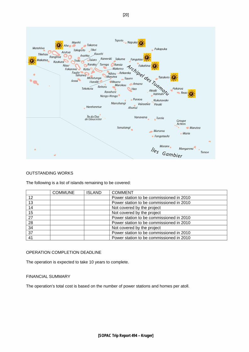
[SOPAC Trip Report 494 – Kruger]
OUTSTANDING WORKS The following is a list of islands remaining to be covered: COMMUNE ISLAND COMMENT 12 Power station to be commissioned in 2010 13 Power station to be commissioned in 2010 14 Not covered by the project 15 Not covered by the project 27 Power station to be commissioned in 2010 28 Power station to be commissioned in 2010 34 Not covered by the project 37 Power station to be commissioned in 2010 41 Power station to be commissioned in 2010
OPERATION COMPLETION DEADLINE The operation is expected to take 10 years to complete. FINANCIAL SUMMARY The operation’s total cost is based on the number of power stations and homes per atoll.
[21]
[SOPAC Trip Report 494 – Kruger]
SOPAC 2010 Funding Plan Contributions Amount (XPF) 2010 Percentage French Polynesian funding Expected French government funding
Expected SOPAC funding Total
Overall Funding Plan Contributions Amount (XPF) 2010 Percentage French Polynesian funding Expected French government funding
Expected miscellaneous funding (communes, EU, etc)
Total Year Number of Installations XPF Amount 557 million TOTAL XPF 5570 million
(46.7 million euros)
[22]
[SOPAC Trip Report 494 – Kruger]
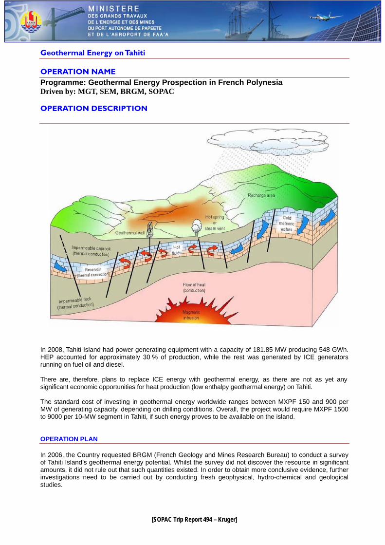
Geothermal Energy on Tahiti OPERATION NAME Programme: Geothermal Energy Prospection in French Polynesia Driven by: MGT, SEM, BRGM, SOPAC
OPERATION DESCRIPTION
In 2008, Tahiti Island had power generating equipment with a capacity of 181.85 MW producing 548 GWh. HEP accounted for approximately 30 % of production, while the rest was generated by ICE generators running on fuel oil and diesel. There are, therefore, plans to replace ICE energy with geothermal energy, as there are not as yet any significant economic opportunities for heat production (low enthalpy geothermal energy) on Tahiti. The standard cost of investing in geothermal energy worldwide ranges between MXPF 150 and 900 per MW of generating capacity, depending on drilling conditions. Overall, the project would require MXPF 1500 to 9000 per 10-MW segment in Tahiti, if such energy proves to be available on the island. OPERATION PLAN In 2006, the Country requested BRGM (French Geology and Mines Research Bureau) to conduct a survey of Tahiti Island’s geothermal energy potential. Whilst the survey did not discover the resource in significant amounts, it did not rule out that such quantities existed. In order to obtain more conclusive evidence, further investigations need to be carried out by conducting fresh geophysical, hydro-chemical and geological studies.
[23]
[SOPAC Trip Report 494 – Kruger]
An initial study has been carried out by BRGM and a second one needs to be undertaken to ascertain the energy’s potential and draft the terms of reference for tapping into it productively. The Country wishes to explore this potential in partnership with SOPAC so as to be able to set up a mixed-investment company on the basis of a geothermal energy consultancy and/or undertake the second study in collaboration with BRGM. OPERATION COMPLETION DEADLINE As per pending BRGM terms of reference FINANCIAL SUMMARY Operation Cost: MXPF 125
F R E N C H P O L Y N E S I A
OFFICE OF THE VICE PRESIDENT RESPONSIBLE FOR AREA PLANNING
COMMUNE DEVELOPMENT LAND
AND RELATIONS WITH THE ASSEMBLY OF FRENCH POLYNESIA
AND THE ECONOMIC SOCIAL AND CULTURAL COUNCIL
GOVERNMENT SPOKESMAN
TOWN PLANNING DEPARTMENT DESIGN AND DRAWING SECTION
No. 70 / AU.EP.int
24/09/09
Case Officer: Emilie Nowak Tel 46 81 50
[24]
[SOPAC Trip Report 494 – Kruger]
Natural Disaster Study Project
Further Characterisation of Marine Submergence Related to Cyclone Swells in French Polynesia:
Ocean swell / lagoon interaction modelling in the Tuamotus Objective Following on from modelling carried out by the Bureau of Geological and Mining Research (BRGM) under Assignment 9 of the ARAI 2 Programme, the risks related to cyclone swell can still be determined for some disaster mitigation plan projects, especially in the Tuamotus. With the land and sea surveying data that the Country government intends to collect through an initiative similar to Mainland France’s Litto3D project, all inhabited atolls could be covered. Otherwise, more piecemeal surveying data could be acquired by this study on at least ten of the Tuamotus’ more populated islands. ARAI 2 Programme’s Assignment 9, which is currently underway, aims at providing a more accurate assessment of cyclone swell impact on the ocean side so as better to determine surf, high energy and submergence zones as well as the restrictions these would imply, particularly in terms of potential building and emergency plans. This supplementary study will attempt to carry the assessment further using increasingly accurate models that simulate swell impact from the ocean into the lagoon and back again. It will also provide data for assessing interaction between swells from the high seas with swells generated in the lagoon. Also, surf and submergence zones could be compared on both ocean and lagoon sides. DEFINING WATER DEPTH AND CURRENT THRESHOLD VALUES The model’s starting data are the same as used previously by BRGM. A climate-change driven sea-level rise value will also be integrated as per the latest world expert estimates. Using the modelling results, a water depth/current velocity coupling could be set, above which housing construction would be prohibited, due to the transport of materials. The thresholds will be set in consultation with the Town Planning Department. APPLYING THRESHOLDS TO THE SUBMERGENCE PARAMETERS OBTAINED Building areas will be mapped for each of the sites examined by crossing the modelling results and thresholds. The results will then be extrapolated for use in regulations applicable throughout the island group. COST ESTIMATE: MXPF 20
[25]
[SOPAC Trip Report 494 – Kruger]
Film with 3D Animation Project:
Climate Change Impact on Natural Disaster Occurrence Objective This project aims at creating communication media, ie a film with 3D images (computer-generated or otherwise), with a view to educating the public on the effects of forecast climate change and providing a decision-making tool for leaders so as to give impetus to land-use planning for the territory that integrates this hazard and covers coastal development and the task of moving exposed persons. The main issue raised will be sea-level rise and its effects on low-lying areas, particularly in the Tuamotus. Other hazards, such as the increasing number and strength of cyclones and the resulting effects, such as landslides and flooding could also be dealt with. COST ESTIMATE: MXPF 3
[26]
[SOPAC Trip Report 494 – Kruger]
Study of the Role Played by Vegetation in Soil Stabilisation and Destabilisation Objective Vegetation cover is one of the factors affecting soil stabilisation. Its impact varies depending on how it is planted and its nature, ie species, density, age, etc. In terms of landslides, vegetation cover acts in various ways, either reducing surface erosion and seepage and improving soil cohesion with its root systems or contributing to destabilising soil by acting as a lever in strong winds or reducing small particle loss or loosening blocks as roots push down into cracks or reducing the spread of landslide material uphill by forming a screen. The role played by vegetation in stabilising slopes is, therefore, a complex issue. In French Polynesia, it can be summarised by asking a number of questions:
- What are the effects of deliberately introduced species such as falcata (for soil protection) or pine (for timber)?
- On the other hand, what role could prolific pest species such as Miconia calvescens have on soil stability?
- What species could be introduced to stabilise slopes? Aspects for assessment:
o effectiveness as stabilisers;
o adaptation to climate and soil;
o requirements for establishing them: seeding with trellises or nets, fascines, planting, cuttings, etc; and
o possible impact on the natural environment’s ecology. STUDY IMPLEMENTATION The study will be conducted in collaboration with the CEMAGREF research institute, who are experts in this type of issue in the European Alps. The first phase will examine the literature and set up a document base as a supplement to the documentation generated by the Disaster Observatory. The research will involve all the issues mentioned above with special emphasis on projects and methods implemented in the Pacific in similar conditions, eg in Hawaii. At the same time, due to the multidisciplinary approach required by the task, potential players already in the Territory will be identified, such as French and foreign research organisations, technical high schools, the territorial departments concerned, such as public works and agriculture. Once identified, they will form a working group to:
- determine the main research orientations and operational applications and sort the issues into sectors;
- when it can, help find solutions for some operational issues;
- define the research and development terms of reference and possibly even design experiment protocols; and
- identify the human and material resources etc and organisations required to carry out the project. The working group will make use of the documentation, which will be added to throughout the project. COST ESIMATE: APPROXIMATELY MXPF 30
[27]
[SOPAC Trip Report 494 – Kruger]
Study on the Role Played by Vegetation in Protecting the Coast from Erosion Objective The issue of vegetation’s role in controlling coastal erosion could be dealt with along the same lines as the study on the role played by vegetation in soil stabilisation and destabilisation in mountainous terrain. The study would be implemented as per the previous project.
COST ESIMATE: APPROXIMATELY MXPF 30
[28]
[SOPAC Trip Report 494 – Kruger]
Statistical Enquiry on Natural Disaster Awareness in French Polynesia Developments in Public Knowledge since the 2006 Enquiry
Objective French Polynesia’s geographical location and its islands’ geology expose the territory to various natural phenomena, such as high winds, storm tides, heavy swell, flooding and landslides. In February 2001, the Natural Disaster Mitigation Plans (PPR) were locally adopted by a vote in the French Polynesian Assembly and an amendment to the country’s land-use planning code. Under the 2000 Development Contract, the French Government and French Polynesia defined the action they would take in terms of mitigating natural disasters and provided the necessary funding. The ARAI programme was implemented by BRGM (geology and mining research bureau) from 2002 to 2006 to meet these objectives, the main one being that the Country should be provided with PPRs in each commune. This natural disaster study was followed up by the current ARAI 2 programme and the Town Planning Department’s PPR unit has been tasked with co-ordinating all activities related to natural disaster mitigation. In 2006, a statistical enquiry was carried out under the ARAI programme to assess French Polynesian public awareness of natural disaster issues and mitigation and, in the process, evaluate information needs. The current survey aims to assess public awareness once again, four years later. The results will then be compared with the 2006 survey to identify the strengths and weaknesses of public awareness. Proposals for preventive information activities will be proposed accordingly.
COST ESIMATE: MXPF 2 (SUBJECT TO CONFIRMATION)
[29]
[SOPAC Trip Report 494 – Kruger]
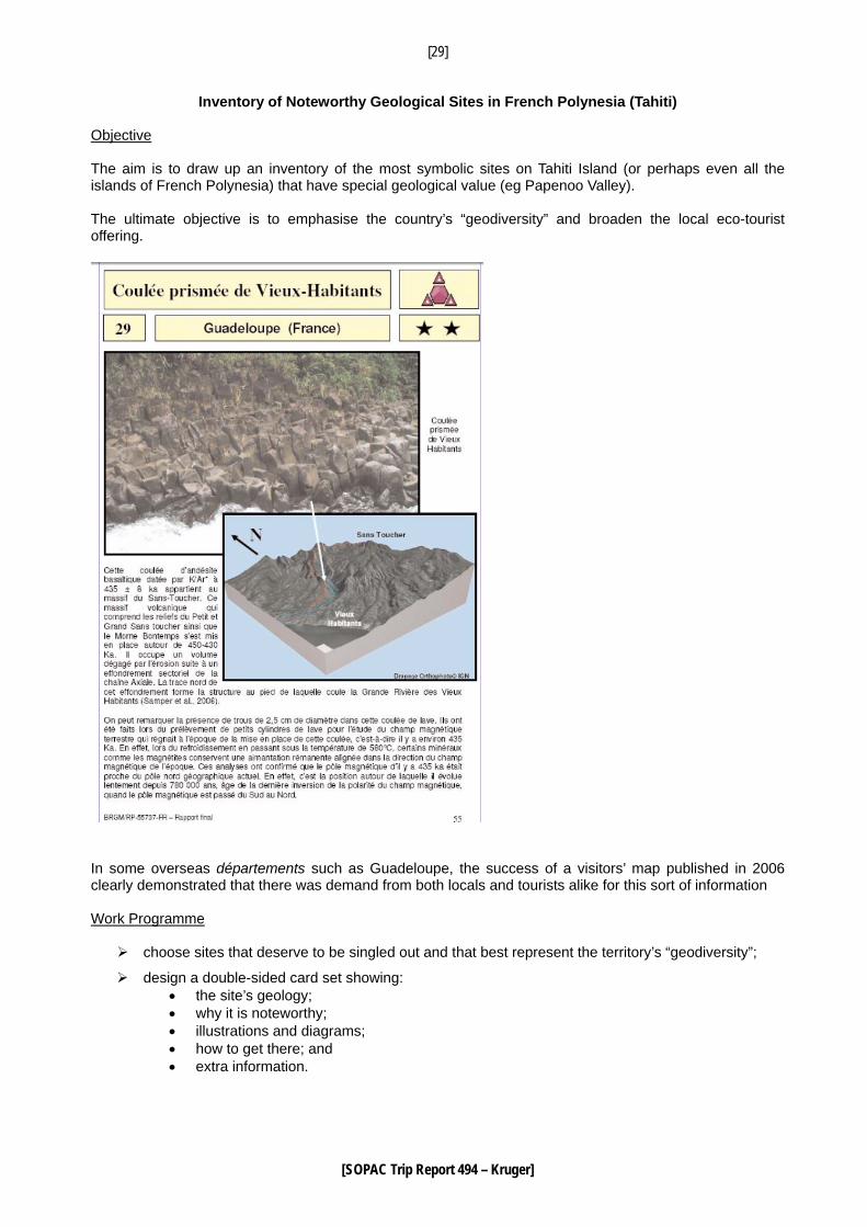
Inventory of Noteworthy Geological Sites in French Polynesia (Tahiti) Objective The aim is to draw up an inventory of the most symbolic sites on Tahiti Island (or perhaps even all the islands of French Polynesia) that have special geological value (eg Papenoo Valley). The ultimate objective is to emphasise the country’s “geodiversity” and broaden the local eco-tourist offering.
In some overseas départements such as Guadeloupe, the success of a visitors’ map published in 2006 clearly demonstrated that there was demand from both locals and tourists alike for this sort of information Work Programme
choose sites that deserve to be singled out and that best represent the territory’s “geodiversity”;
design a double-sided card set showing: • the site’s geology; • why it is noteworthy; • illustrations and diagrams; • how to get there; and • extra information.
[30]
[SOPAC Trip Report 494 – Kruger]
Such an inventory would provide French Polynesia over time with a broad range of information to help the country publicise its geological heritage through various media. An ecotourism pamphlet will be distributed free of charge to tourists and school children as well as being made available in a number of public locations. Other types of publicity could also be envisaged.
COST ESTIMATE: MXPF 3
[31]
[SOPAC Trip Report 494 – Kruger]
Educational Kits on Natural Disaster Awareness for Schools Objective The objective is to develop practical teaching aids on natural disasters that are relevant to French Polynesia. Teacher activity sheets will be designed to assist teachers in setting up classes on natural disasters and mitigation. Low-cost, user-friendly, practical activities will be suggested. These experiment setups will enable junior and senior secondary students to practice real science while educating them further on natural disasters. Work Programme Teacher activity sheets will be published on the various natural phenomena encountered in French Polynesia. They will all be designed along the lines suggested below (taken from a BRGM report on teaching aid design for practical education on earthquake hazards and active tectonics - BRGM/RP-55230-FR, December 2006): - The “Objectives” section summarises the activity sheet’s most important points. - The theoretical section contains scientific data, illustrations and explanations on physical phenomena, in order to help the teacher assess certain concepts and choose what he or she wants to teach. - The practical section, designed as a module set, enables the teacher to illustrate certain phenomena or help students grasp various concepts. It is divided into three parts:
• an initial discussion part that encourages student feedback using documents (photos, cards, press cuttings);
• an experimental part for constructing concepts or validating hypotheses; and • a “known references” part that uses the activity results to return to the theoretical data and
consolidate the learning. Depending on the case, practical activity content can vary from merely illustrating a phenomenon to a full-fledged experiment protocol with parametric studies and hypotheses to validate.
- An IT part requires the students to work on learning applications, such as Internet searches and event-location exercises, etc. - An “Application Exercise” part sometimes requires written exercises. - A “More Information” part provides bibliography suggestions for teachers or even students who wish to learn more. The level (junior or high-school) and the disciplines that could be involved in the activity sheet topic are indicated at the beginning of each sheet. COST ESTIMATE: MXPF 3 (DESIGN AND PRODUCTION OF 1000 KITS)
[32]
[SOPAC Trip Report 494 – Kruger]
Detailed Assessments of Flooding Hazard – more rivers Objective Following on from flooding studies conducted in 2009 by local consultancies on 16 rivers on Tahiti and other French Polynesian islands with project management assistance from BRGM under ARAI 2, further river surveys (modelling and/or consultancies) will be conducted by the Town Planning Department. These studies will be carried out either after riverbed and riverbank management projects have been completed by Public Works or with the aim of lifting decision deferments imposed by the Country government on real estate projects that are incompatible with disaster management projects. COST ESTIMATE: MXPF 20
[33]
[SOPAC Trip Report 494 – Kruger]
Designing a “Light” Bure Project (possible seaside building adaptation) Objective This project aims at designing very light, low-cost, easy-to-build housing (owing to likely destruction by cyclones or tsunamis) that would ease the post-disaster compensation burden. Such housing could be approved in coastal areas prone to hazards such as cyclones and tsunamis, as long as the commune they are to be located in has a fully operational Commune Safety Plan for evacuating vulnerable inhabitants. In addition to the studies, a full-scale prototype will be built on an experimental site.
COST ESTIMATE: MXPF 9

[34]
[SOPAC Trip Report 494 – Kruger]
MINISTRY OF FRENCH POLYNESIA THE ENVIRONMENT No. 1171/MEV The Minister 17 SEP. 2009 Case Officer: Paula Meyer
to
His Excellency the President of French Polynesia Re: Implementation in French Polynesia of the EU-SOPAC programme for Supporting Disaster Risk
Reduction in Pacific Overseas Countries and Territories Ref: Council of Ministers Paper no. 48/09 of 9 September 2009 Enc: Project profile Your Excellency You have alerted the Council Ministers to the upcoming visit to French Polynesia of a Pacific Applied Geoscience Commission (SOPAC) information and scoping mission. Accordingly, you requested the Ministers concerned to provide a project profile outlining the objectives of the EU-SOPAC programme for Supporting Disaster Risk Reduction in OCTs. The programme, which studies the effects of climate change, is able to provide valuable support to the Country in sustainable development terms. Please find attached, therefore, a project profile concerning the programme’s environmental aspects. Yours sincerely Georges Handerson CC: MEV 1 ENV 1 ____________________________________________________________________ B.P. 2551, 98713 Papeete – TAHITI, Polynésie française – immeuble Papineau (5ème étage, aile gauche), rue Tepano JAUSSEN Tél. : (689) 47 83 30 – Fax : (687) 47 83 31 – Email : [email protected]
[35]
[SOPAC Trip Report 494 – Kruger]
MINISTRY OF THE FRENCH POLYNESIA ENVIRONNEMENT Papeete, 16 September. 2009 Case Officer: Paula MEYER
Project Profile
Climate-Change Related Disaster Risk Reduction Climate change is one of the major challenges for the coming years. Rising temperatures, melting glaciers, the increasing number of droughts and floods and sea-level rise are all signs that climate change has already begun. The risk for future generations is worldwide and particularly affects islands, including those belonging to overseas countries and territories, requiring pro-active, effective and speedy action. In March 2009, French Polynesia set up a local climate change network that worked on providing an appraisal of the situation and suggesting a strategy for adapting to and reducing these risks. French Polynesia thereby intends to formulate an ambitious but realistic disaster adaptation and mitigation policy. More accurate information on the expected changes in French Polynesia are crucial for improving our understanding of the risks and attendant consequences, as current modelling is too thinly spread to provide an analysis at the island-group level. Sustainable development measures to reduce French Polynesia’s vulnerability to climate change can, however, already be implemented in the following areas: - use more efficient and cleaner energy; - cleaner and better balanced transport; - make our companies more accountable, without hindering their competitiveness; - make land-use planning and agriculture more responsive to the environment and man’s needs; - create a more favourable climate for innovation; and - obtain a better understanding of coastal vulnerability, lagoon dynamics and the lessons to be learned in
land-use planning terms. _____________________________________________________________________________________ B.P. 2551, 98713 Papeete – TAHITI, Polynésie française – immeuble Papineau (5ème étage, aile gauche), rue Tepano JAUSSEN Tél. : (689) 47 83 30 – Fax : (687) 47 83 31 – Email : [email protected]
[36]
[SOPAC Trip Report 494 – Kruger]
WATER RESOURCES IN FRENCH POLYNESIA IN TERMS OF CLIMATE CHANGE
1. GENERAL OBSERVATIONS ON THE FRESH WATER ISSUE
Fresh water is often around us, flowing invisibly beneath our feet (98 % of the planet’s liquid fresh water is underground) and yet it is part of our daily lives, either directly whenever we turn on a tap to quench our thirst, or indirectly whenever we eat a fruit. To the fruit, water imparts some of its taste and, to us, our survival. Fresh water has become an essential raw material. It might be renewable, but there is no real substitute for it, all the more so with climate change affecting the planet. Indeed:
• per capita fresh-water consumption, regardless of increases or plateaux in the resident or transient population (eg visitors), is on the increase for all uses whether agricultural, industrial or residential. Unless addressed, such increased demand will lead to ever more difficult situations;
• management of surface water and the related ground water is, therefore, a major concern that
requires the various users, whether industrial, agricultural or individual, to change and adapt. This is a source of conflict at the moment and needs to be dealt with quickly.
Management is not the only issue. Quality is also a problem today. Pollution is increasing, particularly industrial and agricultural waste with fertiliser and pesticides being applied for better yields. Pollution not only acts from the surface downwards, but also seeps sideways into groundwater from the sea and salt-water wedges can undermine otherwise prosperous farming. The water issue needs to be considered in the wider context of sustainable development and climate change. Water is a multisectoral resource that is used in all areas of life and subsistence, including security. Having a reliable water supply is a critical issue on many islands today and it is set to worsen in the future. It has clearly been shown that in most climate change scenarios, small island water resources will probably be seriously jeopardised (2008 IPCC report)3
2. CLIMATE CHANGE IMPACT ON GROUNDWATER
Groundwater renewal is determined by long-term climate conditions (groundwater inertia effect). Climate change will therefore have a major impact on groundwater. Despite the lack of detailed knowledge, there is a consensus on qualitative climate change with temperature rises and more variability in rainfall leading to more extreme events such as flooding and drought. The June 2008 IPCC report indicates that annual and seasonal ocean surface and island temperatures have risen by 0.6 to 1.0 % since 1910 in a large part of the South Pacific. Groundwater will be less directly or quickly affected than surface water, but the impact will be just as great. Climate change will alter temperatures and rainfall and it is precisely these two factors that determine groundwater renewal. In the water cycle, the proportion of water seeping into the water tables underground is equal to the amount of rainfall minus the amount of evaporated water used by plants minus surface runoff that directly supplies the watercourses. If the temperature increases, the proportion of evaporated water used by plants will increase to the detriment of water seeping into the ground. Similarly, heavier rainfall (more water in less time), will increase the proportion of runoff, especially when the soil is dry, once again to the detriment of seepage. In an island context, climate change will also affect groundwater in coastal aquifers. According to IPCC scenarios, climate change is going to cause sea-level rise (0.2 to 0.6 m in 2100 and even a spike of up to 1 m in storms with a 10-year return period). For two small coral islands off India, it was estimated that the fresh-water lens would diminish from 25 m to 10 m and from 36 m to 28 m respectively for a sea-level rise of just 0.1 m (2008 IPCC report). In coastal areas, population pressure could also lead to
3 Bates, B. C., Z. W. Kundzewicz, S. Wu et J. P. Palutikof, éd., 2008: Le changement climatique et l’eau, document technique publié par le Groupe d’experts intergouvernemental sur l’évolution du climat, Secrétariat du GIEC, Genève, 236 p.
[37]
[SOPAC Trip Report 494 – Kruger]
increased water needs. Sea-level rise is going to move the seawater/groundwater interface (commonly known as the “saltwater wedge”) and cause the saltwater wedge to rise, threatening drinking water catchments with contamination. In addition to these “natural” phenomena, there are human-induced impacts. Rising temperatures and rainfall variability could generally lead to increased demand for irrigation water, even if total rainfall remains unchanged over the year. This could bring about increased water abstraction for farming, thereby exacerbating groundwater depletion. It will only be possible to conserve groundwater resources under climate change if management strategies are adopted based on reliable climate-change scenarios for small islands. They will have to integrate groundwater conservation, land cover that is favourable to meteoric water seepage, artificial groundwater supplement options using surface or waste water and preferential use of groundwater for drinking water supplies.
3. THE WATER RESOURCE SITUATION IN FRENCH POLYNESIA
The following comments are based on the Economic, Social and Cultural Council’s 2003 report on water resources in French Polynesia, Catherine Gabrie’s report on environmental developments in French Polynesia from 1996 to 2006 and the June 2006 BRGM (geology and mining research bureau) mission report by JF Vernoux..
3.1. General
Although there is enough water on many islands to cover needs for the next 30 years, it is in limited supply on others, such as Maupiti and Bora Bora, where needs have increased with the advent of luxury tourism development. There are also beginning to be concerns over water levels in some wells on Tahiti. The resources are fragile, particularly coastal water that is highly prone to saltwater intrusion and likely to be even more so with sea-level rise (due to climate change) that will cause saltwater wedges to invade coastal aquifers. Major changes have been observed in high-island water supplies with the proportion of groundwater to surface water increasing (from 30/70 to 60/40 on average on Tahiti), as the availability and quality of surface water varies considerably. Consumption varies from one island and commune to another by about 150 l/day/head of pop. on the atolls (sometimes less) to 250 or 350 l/day/head in communes where water is sold for a fee. In rural communes on Tahiti, it can reach 1500 to 2000 l/day/head, ie ten times more than average consumption in France. Also, the amounts used by agriculture and industry are unknown. On average the quality of drinking water in French Polynesia as a whole has improved slightly over the last ten years, with 22 % of samples passing the test in 1995 as against 40 % in 2005, ie a 50 % increase, but these figures do not accurately reflect the disparity between islands. Protective water catchment boundaries have come up against major land tenure problems. Proper regulations have yet to be enacted and protection is, therefore, lacking. Only 32 out of 48 communes have a drinking-water master plan. In late 2006, only 10 % of French Polynesians had access to 100 % regulation-compliant drinking water; 23 % received quality water (over 90 % compliant) as against 14 % in 1996. 46 % of the population had water that was less than 50 % compliant. In ten years an extra 23,000 people, ie some 10 % of the population, received access to drinking water (over 80 % compliant).
3.2. Disparate knowledge of water resources, especially groundwater levels
The State Land Surveying and Management Group (GEGDP), which is part of the Public Works Department, manages state land and, therefore, provides information for drilling applications. It is required to act solely in the public interest, ensuring this heritage is conserved and preserved.
[38]
[SOPAC Trip Report 494 – Kruger]
In French Polynesia, all water abstraction works must be approved with due regard to pumping rates, but there are no set threshold rates as there are in France (8m3/h declared or 80m3 approved) for all water abstraction in the natural environment. The lack of overall water management (ie a water master plan), knowledge on aquifers (hydrological criteria, surface area or renewal capacity, etc) or hydrological advice make it impossible to set an abstraction threshold. The group also has very little aquifer abstraction or piezometric monitoring data in the absence of regulatory requirements for these. Hydrogeological and hydrological knowledge in French Polynesia is still very patchy, as very little research has been undertaken. There is, therefore, no exhaustive inventory of aquifers for all islands or fresh water resources generally. Hydrogeology, on the other hand, is heavily dependent on geology and the French Polynesian islands are the product of volcanic action on the East Pacific Ridge opposite “hot spots” with high magma activity. The islands have a varied morphology depending on their age. Large, high and somewhat younger islands, such as Tahiti, contrast with small, low islands and atolls that are older. On high islands, porous fracture aquifers are found opposite volcanic formations, whilst porous interstice aquifers are associated with weathered formations. As a rule of thumb, the most productive aquifers are volcanic flows in which fracturing plays a dominant role for groundwater, as there is continuity between the various flows. On Tahiti, the volcanic-formation basal aquifer is tapped into by many wells and several high-capacity springs (eg Bain du Roi Spring in Arue Commune with a flow rate of 1000 m3/hr), due to its favourable hydrogeological characteristics. On other high but smaller islands, the basal aquifer is generally not as powerful as Tahiti’s and abstraction can be more difficult with lower flow rates (less than 30 m3/hr) and salination risks. These islands are also lower than Tahiti and have lower rainfall, leading to limited recharging of groundwater units in densely urbanised areas. There are also other much less productive groundwater units in perched aquifers made up of three formation types, ie stream-laid silt, weathering product of basalt formations and fractured basaltic flows. Perched alluvial aquifers can be productive locally, but as the formations vary considerably, their yields are highly uncertain and they are particularly prone to pollution. Low islands and atolls have a very different structure to high islands and, as a result, much less abundant water resources. Atoll volcanic formations are generally less visible, with the volcano cone located below sea level, and atoll surfaces are made up of coral-derived materials. Groundwater is found in small volcanic aquifers or in coral formations in what are known as water lenses held in hydrostatic equilibrium above the seawater that makes up the aquifer wall. In French Polynesia, groundwater use is based on its abundance, hydrogeological knowledge and needs. On Tahiti and Moorea, more than half of production is from groundwater and the ratio is likely to increase in the coming years, as long as the resource lasts. Smaller islands, however, may have difficulty meeting their population’s needs. There, groundwater is also more vulnerable to climate variations. Water supply problems were, for example, experienced on Bora Bora and Maupiti islands following drought. Enhanced knowledge of resources and optimised management are, therefore, absolutely necessary. By way of illustration, short-term restrictions were imposed this year (2009) at Punaauia as a result of drought.
3.3. Lack of Overall Water Management (quantity and quality)
Freshwater reserves, particularly groundwater, still appear not be fully understood in French Polynesia, including Tahiti. As mentioned previously, the resource varies considerably from one island to another, depending on its size and morphological, geological and hydroclimatic configuration. Although Tahiti appears to have abundant water supplies, these need to be described better so as to ensure they remain sustainable and preserve aquifer quality. It is particularly important to gain a better understanding of how the aquifers work and how they are related to rivers and seepage zones as well as to quantify recharge estimates. The other factor that needs to be considered is groundwater quality. One major advantage of groundwater over surface water is that it is naturally better protected from surface pollution, although the protection it enjoys depends on the aquifer’s configuration and the land above it. This can be represented
[39]
[SOPAC Trip Report 494 – Kruger]
on vulnerability maps. By crossing groundwater vulnerability and the pollution pressures, drinking water catchment protection strategies can be put in place. On Tahiti Island, were most of French Polynesia’s industrial activity is concentrated, abstracted aquifers do not appear to have bacterial contamination problems, but it is difficult to diagnose their physical and chemical condition as monitoring is only very partial. The water tables’ inertia can also delay the appearance of pollution that may be at ground level, whether it is sporadic or diffuse. It is particularly important to prevent diffuse pollution related to nitrate and pesticide use. On low islands and atolls, aquifer contamination problems due to seawater can be observed. They can be exacerbated by overuse of the freshwater lens that causes saltwater intrusion. The monitoring programmes that are gradually being set up are vital for evaluating water quantity and quality. A distinction should also be made between catchment protection and resource protection. Studies on protection boundaries and catchment area protection are commune responsibilities and give rise if need be to financial incentives, whereas resource protection takes place at a higher level (at groundwater catchment area level).
4. PROPOSED ACTION PLAN Knowledge about the resource, its management and regulatory issues are three interlinked areas. Without knowledge it is impossible to define the issues, especially future problems and without suitable regulations, it is difficult to implement management and preservation policies. The following action is proposed:
• Enhance knowledge of the resource so as better to manage it • Implement management and decision-making/training tools • Regulations • Integrated approach to resource management
4.1 Resource Knowledge Enhancement for Better Management Resource knowledge relates to aquifer structure and operation in terms of the water balance and abstraction potential (recharge estimate, groundwater storey issues, catchments concentrated in certain areas and vulnerability). Initially, a whole set of measures need to be carried out using the case of Tahiti. If the study turns out to be broadly applicable, it will then be proposed essentially for methodology purposes. The proposed approach, investigation methods used and findings could be applied to other similar islands. The following measures are proposed:
• Collect and consolidate available data locally (on drilling, operation monitoring, quantity and quality, etc) ;
• Carry out a geological and hydrogeological field study including the listing of water springs and
inflows, their physical and chemical descriptions and the description of aquifers (recent or older volcanic formations, nature of the porous facies – splitting, gravel facies, possible fracturing – and non-porous facies and hydrothermal and supergene weathering, etc).
• 2D geophysical exploration by electrical panels using existing boreholes to calibrate it and possibly
with some further test drilling to ascertain the aquifers’ geological structure and understand certain aspects of the freshwater-saltwater relationship, and possibly radon if drilling goes ahead.
• Study on the water table / river relationship to assess the potential for active management
afforded by the underground watercourse system, process and interpret the piezometric record and flow rate in currently used boreholes and any hydrometric and piezometric data in unused boreholes, assessment of the water balance on the scale of the island’s various catchment areas (rainfall, effective rainfall, shooting flows and seepage); instrumentation in the boreholes used for the drinking-water supply and/or long-term trial pumping;
[40]
[SOPAC Trip Report 494 – Kruger]
• Hydrogeochemical approach (majors, traces, isotopes) so as to assess how the aquifers function;
• Develop an integrated water management tool for surface and ground water on an island scale; For the same reasons, it would also be be useful to study an atoll to assess water lens use in both
quantitative and qualitative terms. The study could have two parts: • Freshwater lens modelling, once all the required data have been collected (piezometric study,
test drills using augers fitted with piezometers and electrical geophysics etc, depending currently available data).
• A more specific part (geopurification, artificial recharging using waste water whether
centrally or locally) in collaboration with waste-water recycling experts.
4.2 Use of Management and Decision-Making Tools Major improvements could be made in surface and groundwater management in both quantitative and qualitative terms, which could lead to preserving water for human consumption and developing the region, as hitherto unknown water sources could be tapped. Discussion on this issue could be coupled with training for Country and local government employees in basic hydrology, Polynesian Island hydrology and management tools, etc. The following action is proposed:
• Listing and processing of available data on Tahiti Island, ie updating the Tahiti water resource study conducted by SAFEGE.
• Summary of knowledge and hydrological data for each island, with emphasis on the shortcomings
needing to be addressed. The summary should ideally include an inventory of springs (commune survey) and boreholes, whether used or not.
• Thematic maps to be developed using multicriteria analysis: aquifer typology, recharge (runoff /
seepage), vulnerability, piezometrics, quality and abstraction) • Set up a quantitative and qualitative monitoring network to monitor developments in the
resource (groundwater observatory) and define action programmes; self-monitoring has not really been applied as yet.
• Data pooling and information dissemination on surface and groundwater, including on
regulatory issues (databanks, GIS, Internet) so as to build up a Water Management Information System (WMIS).
• Develop a system for long-term integrated water management with locally adapted methodology
guides (eg on catchment area protection), project management assistance and management models.
4.3 Regulations Water regulation appears to be incomplete or inappropriate, as public initiatives are governed by an overall regulatory framework (e.g. GEGDP for state land). Only the public health centre (CHSP) is working on new regulations, but these could be difficult to apply. Preliminary work could be carried out to assess the technical feasibility of implementing new regulations, improve technical co-ordination between Country government departments (including through training) and with the High Commissioner’s departments. This work could be conducted in partnership with organisations in Mainland France, such as water
[41]
[SOPAC Trip Report 494 – Kruger]
agencies responsible for implementing public water policy. Having an agency tasked with overall management of water (both in quantitative and qualitative terms) should make it possible to co-ordinate the various departments responsible for applying the regulations.
4.4 Integrated Approach to Water Management Currently, the players are essentially located at commune level, where responsibility lies in 2009 for providing a drinking-water supply. In areas where water is abundant, uncontrolled growth in borehole numbers, for example, needs to be prevented, as do clashes between local-government bodies or service providers, the business community and private individuals and, in more general terms, resource depletion. A water management plan, which is currently lacking, must be put in place. The plan, backed by and ad hoc body, will cover all water-related matters:
- Description of groundwater resources
- Groundwater prospection
- Matching needs with resources (consumption assessments, future need forecasting)
- Quantitative and qualitative water monitoring
- Resource and water catchment area protection
- Seawater intrusion prevention for coastal aquifers and atolls
- Monitoring operations likely to contaminate groundwater
- Land-use planning in favour of meteoric water seepage
- Artificial supplements to water tables using surface or waste water
- Social and economic considerations (price of water, waste control, prevention of conflict over use, user accountability, subsidies for local government bodies and service providers and master plans, etc
- Regulation issues (groundwater protection, drinking-water catchment area protection, bottled water, self-monitoring, boreholes, etc)
This initiative will aim to assist the country in setting up an organisation with a view to achieving integrated water management that is mindful the climate change issue.
Hydrodynamic processes at the interface ocean-lagoon on atoll rims and barrier reefs S. Andrefouet (IRD) and A. Lo-Yat (Project manager for PRL) Using funds from the European Community (IX FED), the Institut de Recherche pour le Développement (IRD) and the Service de la Perliculture (PRL) of French Polynesia have recently worked on the characterisation of the 3D circulation in Ahe atoll lagoon, a prime site from pearl oyster aquaculture. The ultimate goal of the work is to understand better the patterns of dispersal/recruitment of oyster larvae inside the lagoon, and to enhance the spatial management of the marine concessions inside the lagoon. The work included four main components:
• one year of in situ measurements (bathymetry, temperature, tide gauges, wave meters on the atoll forereefs, current meters in lagoon, pass, and hoas which are channels locate along the atoll rim, GPS lagrangian measurements),
• characterisation of the morphology of the rim with remote sensing very high resolution images,
• characterisation of the oceanic and atmospheric climate of the western Tuamotu (http://hydro-perli.ird.nc) with a focus on the wave climate made in collaboration with SHOM.
• a high resolution (100 m in the current version) 3D numerical model forced by tide, wind and wave, able to reproduce current patterns and measure connectivity between different areas of the lagoon.
[42]
[SOPAC Trip Report 494 – Kruger]
The model is based on the Mars3d software developed by IFREMER and modified for this application.
The four components are all completed or nearly completed, and the remaining phases will look at model refinement, to run connectivity scenarios, and to establish an Atlas of the lagoon circulation climatology. Takaroa atoll will also be studied, using a shorter set of in situ measurements collected during one campaign only (November 2009). From this work, it appears that both Ahe and Takaroa are atolls well protected from the dominant southerly swells. The physical barrier made by the southern line of large western Tuamotu atolls protects these atolls from high energy swells. Thus, we miss for Ahe and Takaroa the possibility to measure and accurately model the hydrodynamic response of an atoll rim to high swell (1.5 to 4 meter significant wave height). This is necessary to be able to generalize our findings to other atoll configurations, more exposed to southerly swells, such as Arutua or Raroia for instance. Moreover, similar studies would be extremely useful to characterise the environment of Mangareva lagoon in Gambier Archipelago, which is bounded by a barrier reef (drowned in the south and intertidal on the western, north and eastern side). We propose, PRL and IRD to work with SOPAC on the physical characterisation of pearl oyster aquaculture atolls and islands under normal, non-extreme conditions. This complements the work in progress by Service de l’Urbanisme for risk assessment under extreme, cyclonic, conditions (“action 9 du programme ARAI 2”). The objectives are different and complementary in terms of atoll and island economic development and inhabitants well being and safety. Technically, the work to conduct jointly consists in:
- multibeam bathymetric survey (SOPAC and IRD), with portable multibeam system from SOPAC and multibeam system on board RV Alis, which will be in French Polynesia part of 2010 and in 2011.
- in situ measurements of current velocities and directions (SOPAC, Service de la Perliculture and IRD), using instruments from the 3 partners, serviced by SOPAC and IRD staff.
- Geomorphological characterisation of shallow atoll rims and barrier reef using remote sensing data
- Characterisation of the wave climate of the targeted sites, using Wavewatch model data, altimetry and in situ observations. The possibility to deploy with SOPAC a wave buoy would be critical on this matter and of high interest to scientist working on wave climate. If SOPAC decides to deploy such sensor, a demand can be made to use RV Alis to deploy the instrument, or the RV Alis can be chartered by SOPAC in 2010 or 2011 if the delays are too short for a traditional cruise demand.
- Model (2D, 3D) by SOPAC and IRD the response of current and set up along studied rims and barriers using the data collected.
- Transfer to PRL the environmental knowledge gained by these studies. Participation of IRD will consist in completing funds provided by SOPAC for the project, namely with IRD instruments, salary time for the dedicated time of instrument engineers, permanent scientists, RV Alis crew (if ship is requested) and administration. PRL will provide its instruments purchased for the Ahe atoll project. Participation is asked to SOPAC for field trips (2 campaigns with travels from Noumea since IRD staff is based in Noumea), salary time for one engineer part time for one year to assist the project in Noumea, and for close interaction with SOPAC in Fiji at the time of the modelling, result interpretations and report writing. Based on the Ahe project, costs are estimated to be around 80 K€, preferentially as subcontract to IRD if feasible. Additional SOPAC expenses are needed for shallow multibeam deployment, wave buoy acquisition deployment, SOPAC staff field trips, SOPAC staff salary time.
October 2009