Embed Size (px)
Citation preview
© D
HI
La Réunion’s heavily trafficked coastal highway regularly faced threats from
falling rocks and cyclones, often making it unsafe for vehicles to pass. As such,
the Regional Government of La Réunion commissioned Egis to design and
build a new, safer highway. We assisted them by using physical model testing
to ensure the structural integrity of the new highway design.
CONTRIBUTING TO THE DEVELOPMENT OF A NEW COASTAL HIGHWAY
Every day, more than 58,000 vehicles use the 13 km long coastal highway that
connects Saint Denis and La Possession – La Réunion’s two largest cities. In the
past, falling rocks from the cliffs above the highway have caused many fatal
accidents and road closures. In addition, the highway must also be closed when
severe cyclones are predicted for the island due to the threat of heavy, cyclone-
generated waves washing over the existing highway. In order to alleviate these
threats, the Regional Government of La Réunion has decided to design and build a
new, safer highway.
The Conseil Régional de la Réunion asked Egis (a French consultancy) to design
the new highway. Specialised experts conducted detailed studies to determine the
trajectories of the falling rocks and landslides experienced at the site.
SUMMARY
CLIENT
Egis, on behalf of the Regional Government of La Réunion
CHALLENGE
Need to ensure the safety of the design of a new highway that will be located in a highly exposed coastal environment with high wave impact
SOLUTION
Conducting physical model tests to optimise and validate the structural integrity of the new highway
VALUE
Helped Egis develop safe and economically optimised structures for the new highway
LOCATION / COUNTRY
Île de la Réunion, France
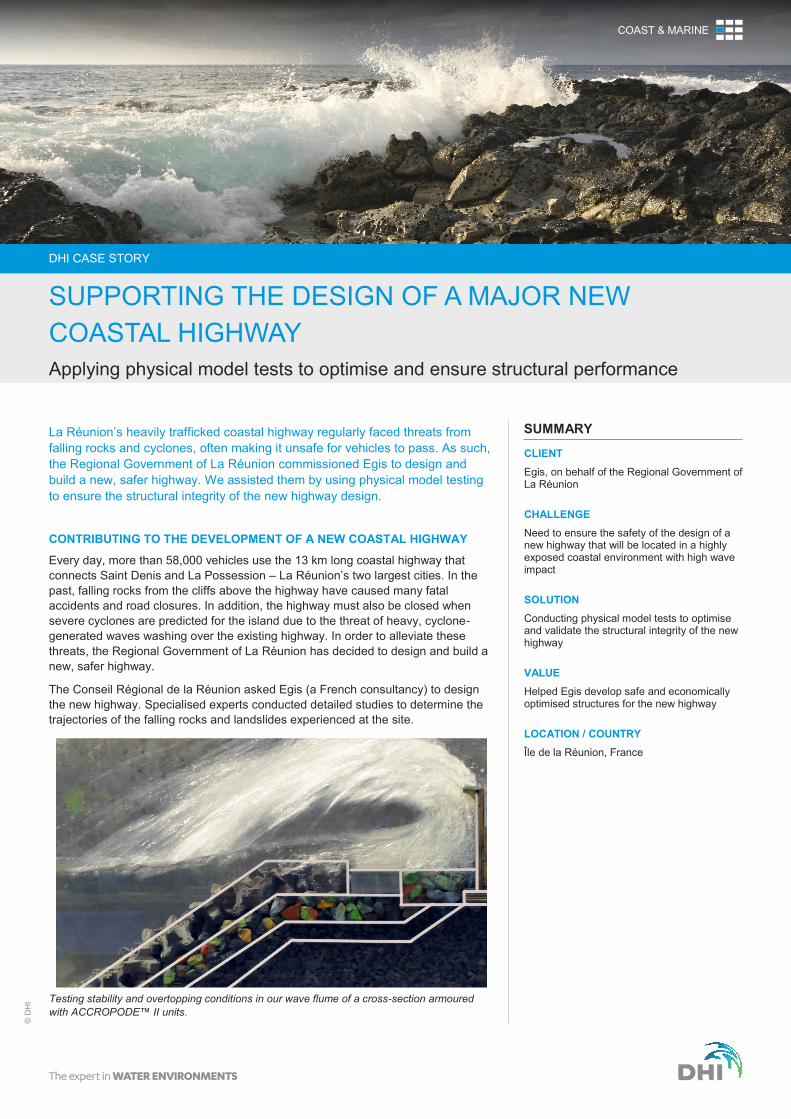
Testing stability and overtopping conditions in our wave flume of a cross-section armoured
with ACCROPODE™ II units.
DHI CASE STORY
SUPPORTING THE DESIGN OF A MAJOR NEW
COASTAL HIGHWAY
Applying physical model tests to optimise and ensure structural performance
COAST & MARINE
Based on this information, it was decided to build the new
highway – partly on rubble mound revetments and partly on
viaducts – located further away from the cliffs than the existing
highway. This would still place the new highway in a marine
environment with high wave impact, but at safe distance from
the falling rock. To support Egis in building the new highway,
we:
determined the design wave conditions
conducted physical scale model tests to optimise and verify
the stability and overtopping conditions of the new coastal
structures during extreme wave impact
ASSESSING DESIGN WAVE CONDITIONS
Trade winds and cyclones govern the wave climate at La
Réunion. Waves due to trade winds occur regularly, however
they are not extreme. Cyclone waves, which strike the island
occasionally, cause the extreme wave conditions that were
used to design the new coastal road. We used our MIKE by
DHI numerical modelling and analyses tools to determine the
design wave conditions based on a hindcast study of historical
and synthetic cyclones, followed by statistical analyses.
PHYSICAL MODEL TESTING OF REVETMENTS CROSS-
SECTIONS
First, we tested the efficiency of different types of cross-
sections of the rubble mound revetments in a wave flume. We
varied the following parameters:
geometry of the cross-sections
type of armour units
toe structure
deflecting wave screens
Since depths along the new alignment of the highway vary
between 5 m and 11 m, we tested these cross-sections at four
different depths (5 m, 7 m, 9 m and 11 m). Using the data
from these tests, we developed a typical cross-section that
met the criteria for acceptable overtopping discharges as well
as armour and toe stability.
Next, we tested stability and overtopping conditions of specific
stretches of the causeway in our wave basins, including:
transitions between rubble mound and viaduct
junctions
bends
outlets/culverts through the revetment
outlets of canyons
These tests assessed the effects of the three-dimensional
geometry of the causeway and variations of the seabed in
front of the structures, ensuring the successful design of these
specific stretches.
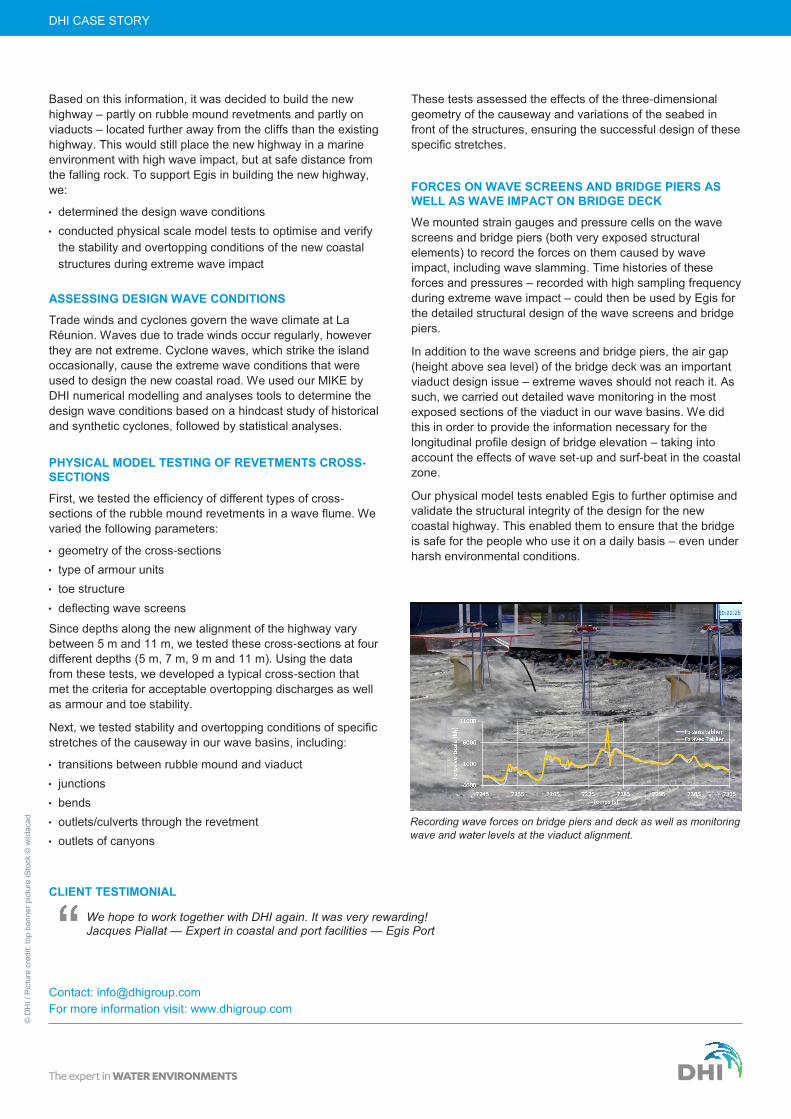
FORCES ON WAVE SCREENS AND BRIDGE PIERS AS
WELL AS WAVE IMPACT ON BRIDGE DECK
We mounted strain gauges and pressure cells on the wave
screens and bridge piers (both very exposed structural
elements) to record the forces on them caused by wave
impact, including wave slamming. Time histories of these
forces and pressures – recorded with high sampling frequency
during extreme wave impact – could then be used by Egis for
the detailed structural design of the wave screens and bridge
piers.
In addition to the wave screens and bridge piers, the air gap
(height above sea level) of the bridge deck was an important
viaduct design issue – extreme waves should not reach it. As
such, we carried out detailed wave monitoring in the most
exposed sections of the viaduct in our wave basins. We did
this in order to provide the information necessary for the
longitudinal profile design of bridge elevation – taking into
account the effects of wave set-up and surf-beat in the coastal
zone.
Our physical model tests enabled Egis to further optimise and
validate the structural integrity of the design for the new
coastal highway. This enabled them to ensure that the bridge
is safe for the people who use it on a daily basis – even under
harsh environmental conditions.
DHI CASE STORY ©
DH
I /
Pic
ture
cre
dit:
top
ba
nn
er
pic
ture
iS
tock ©
wild
aca
d
Recording wave forces on bridge piers and deck as well as monitoring
wave and water levels at the viaduct alignment.
Contact: [email protected]
For more information visit: www.dhigroup.com
CLIENT TESTIMONIAL
We hope to work together with DHI again. It was very rewarding! Jacques Piallat — Expert in coastal and port facilities — Egis Port