Embed Size (px)
Citation preview
15th meeting of the Groundwater Modellers’ Forum 8th November 2017, Birmingham
Integrated models for long-term planning in a changing world
1
Surface Water Accounting Model, SWAc – linking surface flow and
recharge processes to groundwater models
Alastair Black1, Marco Lagi2
1Groundwater Science Ltd ([email protected]) 2New England Complex Systems Institute
Abstract
Representation of topologically routed surface water systems, distributed recharge and riparian
demand in groundwater models is frequently desired, but challenging to implement, in a
conceptually robust, mass-conservative and time-efficient manner. Various tools exist to assist
in the generation of MODFLOW recharge and stream input files, however the tools are generally
closed-source and limited in the processes which are represented. Furthermore, existing tools
are typically developed for a single climatic region.
SWAc is a deterministic and distributed model to aid the evaluation of how water is partitioned
through processes between rainfall and recharge, surface flows and AE. The output files include
MODFLOW-USG and MODFLOW96-05 compatible Recharge (RCH), Stream (STR), Streamflow-
Routing (SFR) and Evapotranspiration (EVT/ETS) files alongside tabulated water balances for
defined areas. SWAcMOD is developed to be an accessible, open-source tool, of modular design
and for multiple climatic regions.
The program is developed in Python, is free and is released under the GPLv3 licence model to
meet accessibility needs.
To optimise runtimes, three strategies have been implemented: parallelization, vectorization
with NumPy and use of Cython. The combined effect in the presented model is a 25-fold speed-
up in runtime.
The intent of SWAc is to provide an efficient, accessible means to simulate surface water systems,
distributed recharge and riparian demand into MODFLOW.
Keywords: MODFLOW, Runoff, Recharge, Surface Water
Introduction
Groundwater models are expected to represent observed groundwater level fluctuation and in
many instances additionally simulate groundwater interaction with surface water systems and
wetlands. The representation of groundwater level trends and seasonal fluctuation relies upon
the appropriate magnitude and timing of recharge inputs to the groundwater model, which
typically are highly variable spatially. Within groundwater modelling studies the use of basic
estimates of recharge directly from rainfall records is not uncommon due to: a) relative difficulty
in creating these files; and, b) The uncertainty in the parameterisation of processes which delay,
attenuate and partition rainfall between groundwater recharge, surface flow and actual
evapotranspiration. Without robust inputs ability for the groundwater model to represent

15th meeting of the Groundwater Modellers’ Forum 8th November 2017, Birmingham
Integrated models for long-term planning in a changing world
2
observed responses is unlikely and potentially erroneous calibration of aquifer properties may
be undertaken to compensate for recharge timing and magnitude deficiencies.
The Surface Water Accounting Model (SWAcMOD) program is presented herein. In an effort to
overcome the above challenges to comprehensively represent the surface and near surface
systems in MODFLOW groundwater models:
1. The program directly produces the bespoke input files for the industry standard
groundwater modelling tool MODFLOW, including Unstructured Mesh versions (Panday
et al., 2013). MODFLOW6 (Langevin, 2017) files are in progress.
2. SWAcMOD incorporates a collection of peer reviewed processes which can be optionally
enabled depending on the conceptual system which the modeller wishes to simulate.
3. Topologically routed river networks can be simulated.
4. The modelling package is designed to take advantage of increasingly parallel computing
architectures reducing runtimes.
5. SWAcMOD is released under the GNU GPLv3 open source licence and written in the
Python language to maximise accessibility.
Overview
SWAcMOD comprises a workflow of sequential processes. Each process is derived from existing
studies referenced in literature, many of these are described in greater detail by Heathcote et al.
(2004) and Markstrom et al. (2015). Processes can be optionally enabled or disabled depending
on the needs of the site being modelled. The program is of modular design permitting additional
processes to be added or adapted within the existing workflow.
The workflow constitutes a 1D model from ground surface down through the soil zone and
unsaturated zones. The 1D model requires, as a minimum, rainfall and potential
evapotranspiration (PE). Additionally, temperature and solar flux time series data may be input
alongside these parameters controlling how water is partitioned through each process. Figure 1a
summarises the 1D workflow.
Represented processes include:
• Canopy / vegetation interception and evaporation;
• Temperature-dependant precipitation as snowfall or rainfall;
• Snowpack development and melt;
• Partitioning of rainfall / melt water as rapid runoff;
• Soil moisture accounting and actual evapotranspiration (AE) calculation;
• Additional shallow ponding and impervious zone enhancements to the soil moisture
accounting;
• Urban water mains or canal leakage;
• Interflow and combined near surface lateral flow processes;
• Attenuation of recharge as it passes through the unsaturated zone;
• Surface flow time of concentration attenuation;
• Surface water abstractions and discharges; and
15th meeting of the Groundwater Modellers’ Forum 8th November 2017, Birmingham
Integrated models for long-term planning in a changing world
3
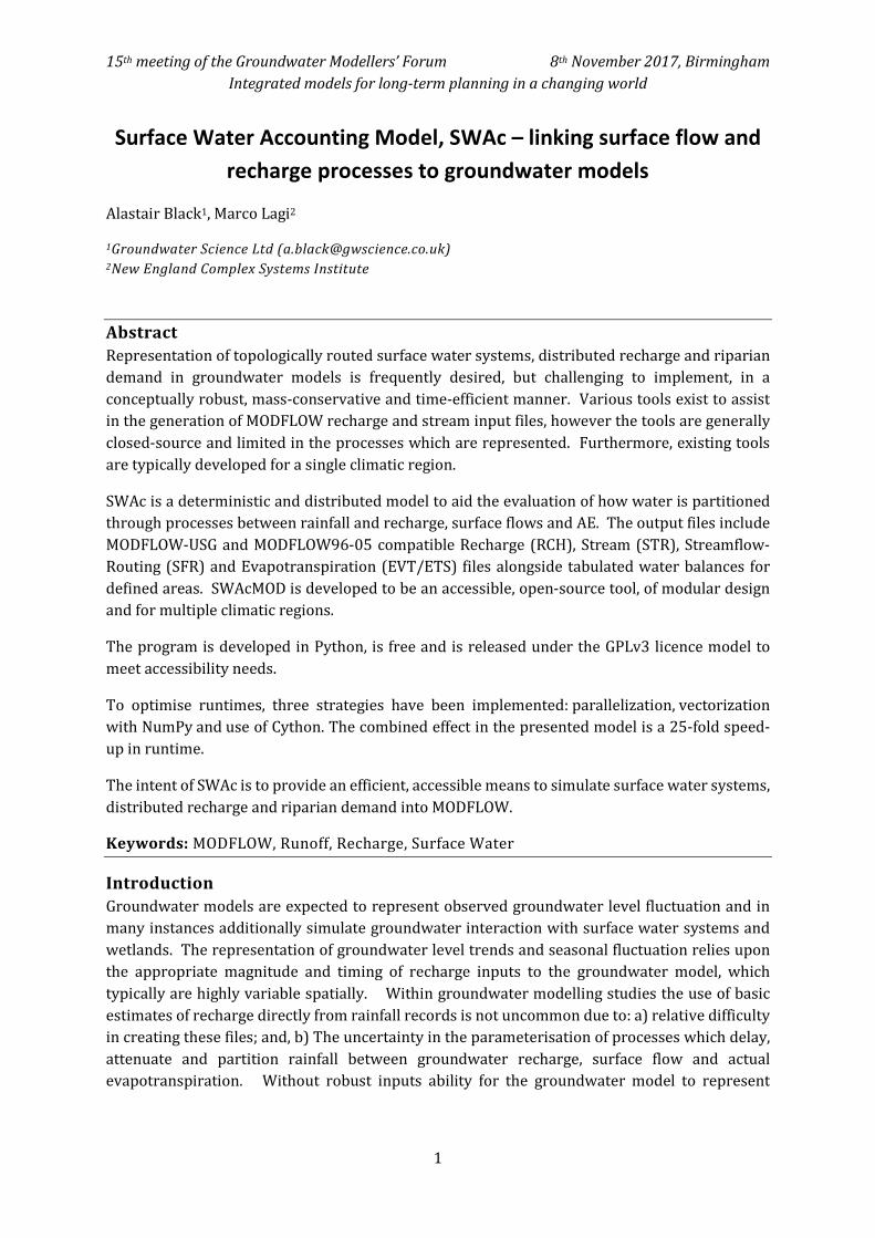
• Bypass mechanisms of rejected recharge, macropore recharge and runoff recharge.
The 1D workflow is duplicated for each and every groundwater model cell, however the spatially
variable parameters controlling each property can be spatially implemented either by zones of
identically parameterised cells or via specification of unique values per cell. By this system the
2D parameterisation of the model can be readily setup. Figure 1 (right) is an example of zonal
input of model properties in SWAcMOD at the scale of the MODFLOW-USG groundwater model
mesh. Each of the polygonal cells hosts a 1D workflow as presented in Figure 1 (left).
Figure 1: Left: SWAcMOD 1D process workflow. Right: Parameterisation by zones on a MODFLOW-USG
mesh
15th meeting of the Groundwater Modellers’ Forum 8th November 2017, Birmingham
Integrated models for long-term planning in a changing world
4
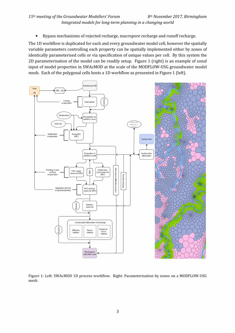
Figure 2 is an example catchment summary for a model located in the centre of Finnish Lapland.
Processes enabled in this model include snowfall-pack and melt, rapid runoff, Soil Moisture
Deficit and AE accounting via an adapted form of the FAO56 methodology Allen et al (1998),
interflow, macropore bypass recharge (rapid recharge), secondary recharge from runoff
(important for representation of observed increased melt recharge as approach surface water
courses), surface water attenuation and groundwater recharge lag and attenuation. All processes
down to the interflow store have time variant properties to permit soil freeze.
Figure 2: Break-down of the outputs from SWAcMOD processes for a catchment in central Finnish Lapland.
All units in this figure are millimetres and the temporal resolution is daily.
15th meeting of the Groundwater Modellers’ Forum 8th November 2017, Birmingham
Integrated models for long-term planning in a changing world
5
Uncertain model properties have been constrained through calibration to river flow gauging,
measured snow thickness (green dots in Figure 2) and Sentinel Satellite ESA (2017) derived snow
cover spatial distributions over time. In addition, several properties, for example rapid runoff
characteristics and vegetation rooting depths, have been estimated based on experience from
past studies and reference material respectively.
The bottom three plots represent time series inputs for MODFLOW-USG and are the primary
outputs for SWAcMOD. These are the ‘surface component of total river flow’ (all excluding
baseflow), ‘Unutilised PE’ (the input to control riparian evapotranspiration) and ‘recharge to the
saturated zone’. These three outputs are spatially distributed however this plot summarises the
average daily time series values for this aggregated catchment area.
Conclusion
Surface Water Accounting Model (SWAcMOD) has been developed to be an open, accessible,
adaptable and fast tool. Its purpose is to enable better representation of time variant and spatially
heterogeneous recharge, actual evapotranspiration and river flows for MODFLOW groundwater
models. Alongside a groundwater modelling package like MODFLOW-USG or MODFLOW6 this
assists in the integration of catchment water balances. SWAcMOD is designed to work in
sequence with MODFLOW and is compatible with the Unstructured Grid versions. The methods
included within the SWAcMOD program are based on peer-reviewed methods. However, the
holistic framework to pull the processes together, generate river topology in unstructured mesh
models and, particularly, the methods to invoke parallelisation – reducing runtimes – are
considered advancements. In addition, barriers to robust representation of recharge are
considered to result from data scarcity in many studies. The SWAcMOD program has been
designed to make use of newly available high resolution and free satellite datasets which help to
constrain several spatially and temporally variable processes. This, in combination with
conventional ground station based data, is a significant improvement in what has been openly
available in recent years.
References
Allen et al. 1998, Crop evapotranspiration - Guidelines for computing crop water requirements -
FAO Irrigation and drainage paper 56
Heathcote et al. 2004, Rainfall routing to runoff and recharge for regional groundwater resource
models. Quarterly Journal of Engineering Geology and Hydrogeology, 37, 113-130
Langevin, C.D., Hughes, J.D., Banta, E.R., Niswonger, R.G., Panday, Sorab, and Provost, A.M., 2017,
Documentation for the MODFLOW 6 Groundwater Flow Model: U.S. Geological Survey Techniques
and Methods, book 6, chap. A55, 197 p., https://doi.org/10.3133/tm6A55.
Panday, Sorab, Langevin, C.D., Niswonger, R.G., Ibaraki, Motomu, and Hughes, J.D., 2013,
MODFLOW–USG version 1: An unstructured grid version of MODFLOW for simulating
groundwater flow and tightly coupled processes using a control volume finite-difference
formulation: U.S. Geological Survey Techniques and Methods, book 6, chap. A45, 66 p
Markstrom, S.L., Regan, R.S., Hay, L.E., Viger, R.J., Webb, R.M.T., Payn, R.A., and LaFontaine, J.H.,
2015, PRMS-IV, the precipitation-runoff modeling system, version 4: U.S. Geological Survey
Techniques and Methods, book 6, chap. B7, 158 p., https://dx.doi.org/10.3133/tm6B7


![Sea Water Air Conditioning [SWAC]: A Cost Effective Alternative](https://img.pdfslide.net/doc/110x75/5883e2841a28ab62358b6a01/sea-water-air-conditioning-swac-a-cost-effective-alternative.jpg)