Embed Size (px)
Citation preview
Surface water, hydrology and flooding This section summarises the results of the surface water, hydrology and flooding assessment that was completed for the proposal. The detailed assessment is provided in Appendix J.
6.2.1 Methodology The surface water assessment adopted the following methodology:
• Review of available water quality, flooding data and existing conditions to obtain background information on catchment history and land use and define the existing environment
• Identification of the potential impact of construction and operational activities and potential cumulative impact on water quality with reference to the ANZECC/ARMCANZ (2000) water quality guidelines and NSW Water Quality Objectives (WQOs) for protection of the relevant environmental values
• Development of water quality treatment measures to mitigate the impact of construction on water quality, following the principles of the Managing Urban Stormwater: Soils and Construction, Volume 1 (Landcom 2004) and Volume 2D (DECC 2008)
• Development of water quality treatment measures to mitigate the impact of the operation of the proposal on water quality following the principle of Procedure for Selecting Treatment Strategies to Control Road Runoff (RTA 2003) and Roads and Maritime Water Policy (RTA 1997)
• Development of any additional measures to manage potential cumulative impact resulting from the proposal.
The flooding assessment adopted the following methodology:
• Review of available flooding data and previous flooding assessments • Preparation of flood modelling for a number of flooding scenarios for the proposal design as part of a
flooding modelling report (BMT WBM, 2019) • Assessment of the impact of construction and operational activities for the proposal on flooding • Identification of measures to manage potential flooding impacts.
6.2.2 Existing environment
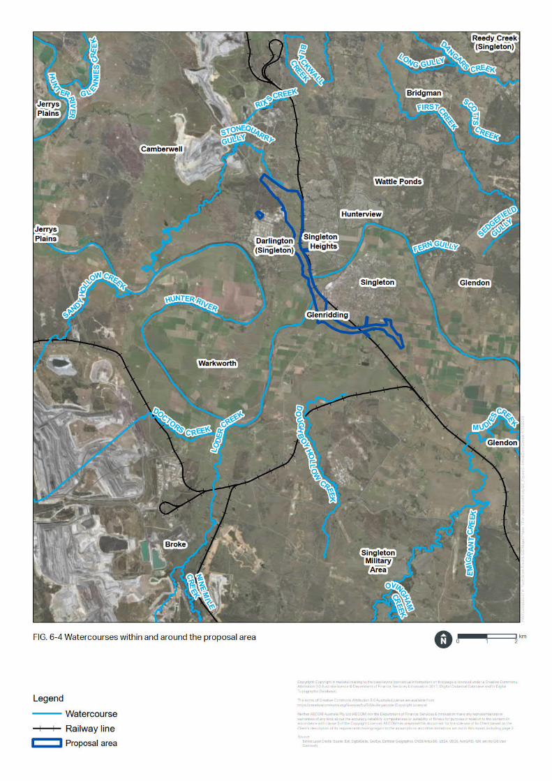
Surface water features Singleton is situated to the north and south of the Hunter River. The Hunter River begins on the western slopes of the Mount Royal Range, part of the Great Dividing Range, east of Murrurundi, and flows generally south-west and then south-east before flowing into the Pacific Ocean at Newcastle. Around Singleton the Hunter River has a catchment area of roughly 16,000 square kilometres. At Singleton, the Hunter River bed has eroded below the level of the floodplain to create a deep incised channel. The incised channel is about 80 to 90 metres wide at the top of the bank.
Other key surface water features include the Doughboy Hollow and Glenridding floodway (refer below for further detail). The proposal would traverse the Hunter River, the Doughboy Hollow and Glenridding floodway and a number of unnamed watercourses. The unnamed watercourses are located:
• North of the Hunter River crossing, flowing south from Maison Dieu Road, capturing flows from McDougalls Hill and the approved Gowrie subdivisions
• North of Gowrie Gates where crossings of tributaries to an unnamed watercourses drain to the east towards Lachlan Avenue in Singleton Heights.
New England Highway bypass of Singleton Review of Environmental Factors
92

A number of other watercourses are located near the proposal area, but are not traversed by the proposal:
• Mudies Creek, south-east of the southern connection
• Doughboy Hollow Creek, south of Glenridding
• Stone Quarry Gully, north of the northern connection. Figure 6-4 shows the watercourses within and surrounding the proposal area.
New England Highway bypass of Singleton Review of Environmental Factors
93
Water quality Upstream of the proposal, mining and agriculture are key influences on the water quality in the Hunter River catchment. The receiving waterways near to the proposal area are regarded as moderately disturbed.
Electrical conductivity (a measure of the salinity of water) in the Hunter River has been measured regularly since 1993 at gauging station ‘Hunter U/S Singleton’. This station is located about 700 metres upstream of the existing Main North Railway Bridge over the Hunter River.
The release of flows to the Hunter River is regulated upstream which influences water quality downstream at Singleton. Irrigation water is normally released to the Hunter River upstream from Glennies Creek Dam, which assists in keeping electrical conductivity low. When Glennies Creek Dam is not releasing water, the primary influence on salinity is from Glenbawn Dam which is located in the upper reaches of the Hunter River. Flows from Glenbawn Dam are associated with higher levels of salinity and generally increase salinity at the ‘Hunter U/S Singleton’ to around 800 μS/cm when Glennies Creek Dam is not releasing water.
Discharges of saline water into the Hunter River catchment is permitted only during periods when the Hunter River is in high flow or flood flow, and only by persons who hold licences that authorise such discharges (discharge licences) under the Hunter River Salinity Trading Scheme.
Water quality monitoring of total suspended solids (TSS) and pH is carried out at Rixs Creek Mine and Bulga Coal Complex. The water monitoring data is summarised in Table 3-2 of Appendix J. The results indicated variable levels of TSS and pH, including elevated levels for both parameters (indicating a more alkaline water quality with higher amounts of suspended solid) which are likely a result of nearby mining and agricultural activities.
The water source at Singleton is part of the Water Sharing Plan for the Hunter unregulated and alluvial water sources. The report card for the Singleton water source prepared as part of the water sharing plan (NSW Department of Water and Energy, August 2009) identifies the following:
• There is low economic dependence of the local community on water extracted for irrigation • There is low risk to instream value (from water extraction) • There is medium relative instream value (within catchment) given:
o The presence of two threatened bird species, three threatened amphibian species and one endangered ecological community
o Moderate fish community integrity o Moderate ecology value for invertebrates.
Given the outcomes from the report card for the Singleton water source, the trigger values for physical and chemical stressors for ‘South-East Australian slightly to moderately disturbed lowland rivers’ (ANZECC, 2000) have been applied to the assessment of potential impacts to water quality in the proposal area and are summarised in Table 6-9. Existing water quality within the proposal area is generally considered to be below or within the trigger values in Table 6-9.
Table 6-9: Proposal water quality objectives trigger values and associated indicators
Trigger Trigger value
Chlorophyll-a 3 µg/L
Total Phosphorus (TP) 25 µg/L
Total Nitrogen (TN) 350 µg/L
Dissolved Oxygen Aquatic ecosystems (Lowland rivers): 85% saturation Drinking water: greater than 80% saturation
New England Highway bypass of Singleton Review of Environmental Factors
95
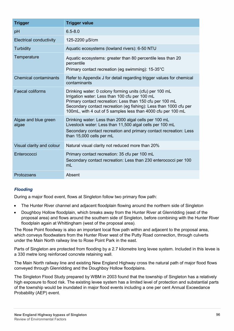
Trigger Trigger value
pH 6.5-8.0
Electrical conductivity 125-2200 µS/cm
Turbidity Aquatic ecosystems (lowland rivers): 6-50 NTU
Temperature Aquatic ecosystems: greater than 80 percentile less than 20 percentile Primary contact recreation (eg swimming): 15-35°C
Chemical contaminants Refer to Appendix J for detail regarding trigger values for chemical contaminants
Faecal coliforms Drinking water: 0 colony forming units (cfu) per 100 mL Irrigation water: Less than 100 cfu per 100 mL Primary contact recreation: Less than 150 cfu per 100 mL Secondary contact recreation (eg fishing): Less than 1000 cfu per 100mL, with 4 out of 5 samples less than 4000 cfu per 100 mL
Algae and blue green algae
Drinking water: Less than 2000 algal cells per 100 mL Livestock water: Less than 11,500 algal cells per 100 mL Secondary contact recreation and primary contact recreation: Less than 15,000 cells per mL
Visual clarity and colour Natural visual clarity not reduced more than 20%
Enterococci Primary contact recreation: 35 cfu per 100 mL Secondary contact recreation: Less than 230 enterococci per 100 mL
Protozoans Absent
Flooding During a major flood event, flows at Singleton follow two primary flow path:
• The Hunter River channel and adjacent floodplain flowing around the northern side of Singleton • Doughboy Hollow floodplain, which breaks away from the Hunter River at Glenridding (east of the
proposal area) and flows around the southern side of Singleton, before combining with the Hunter River floodplain again at Whittingham (west of the proposal area).
The Rose Point floodway is also an important local flow path within and adjacent to the proposal area, which conveys floodwaters from the Hunter River west of the Putty Road connection, through culverts under the Main North railway line to Rose Point Park in the east.
Parts of Singleton are protected from flooding by a 2.7 kilometre long levee system. Included in this levee is a 330 metre long reinforced concrete retaining wall.
The Main North railway line and existing New England Highway cross the natural path of major flood flows conveyed through Glenridding and the Doughboy Hollow floodplains.
The Singleton Flood Study prepared by WBM in 2003 found that the township of Singleton has a relatively high exposure to flood risk. The existing levee system has a limited level of protection and substantial parts of the township would be inundated in major flood events including a one per cent Annual Exceedance Probability (AEP) event.
New England Highway bypass of Singleton Review of Environmental Factors
96
Flood modelling of existing conditions indicates that the Singleton flood levee along the Hunter River bank is not overtopped by floods up to and including the one per cent AEP event. However, modelling indicates that the one per cent AEP event would overtop the Main North railway line in the vicinity of John Street and the railway station, resulting in extensive inundation of residential properties.
The Main North railway line embankment and local topography create a damming effect during flooding which results in flooding in the Doughboy Hollow floodplain. The damming effect increases the likelihood of overtopping of the Main North railway line from the west to the east and subsequent flooding of the township.
Flood modelling identified that the New England Highway south of Singleton is inundated for a flooding event greater than the 10 per cent AEP event.
6.2.3 Potential impacts
Construction Surface water quality
Construction activities represent a risk to surface water quality within local receiving waters. During runoff events or flood conditions, sediment laden waters, chemicals stored on site, and construction waste have the potential to mobilise and enter watercourses.
Generation of sediment laden waters and offsite transport can occur during activities such as:
• Clearing and grubbing • Stockpiling of materials • General earthworks • Temporary works i.e. access roads, compounds, laydown areas and pads • Construction of bridge piers and abutments • Instream drainage works • Placement of fill for embankments. Sediment laden waters pose a potential risk to downstream surface water quality. Water quality impact includes (but not limited to) increased turbidity, elevated concentration of nutrients and other pollutants, such as heavy metals and organic chemicals. The mitigation measures in Section 6.2.4 would minimise the potential for impacts.
Other potential sources that may impact surface water quality during construction include:
• Fuel or oils used by construction plant and equipment • Waste and litter from building activities and personnel • Release of nutrients from fertilisers, herbicides and pesticides (eg used in site landscaping) • Paint and paint wastes • Acids from acid-based washes • Disturbance of contaminated soils and/or acid sulfate soils, which may adversely affect water chemistry
including pH and dissolved solids.
The outcome of the assessment of potential construction water quality impacts to environmental values and associated indicators of the NSW WQOs is summarised in Table 1-1 and provided in full in Appendix J. The assessment in Table 6-10 considers the application of the mitigation measures outlined in Section 6.2.4.
New England Highway bypass of Singleton Review of Environmental Factors
97
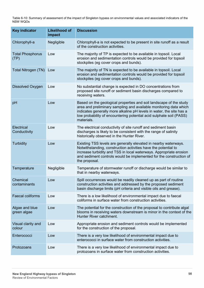
Table 6-10: Summary of assessment of the impact of Singleton bypass on environmental values and associated indicators of the NSW WQOs
Key indicator Likelihood of impact
Discussion
Chlorophyll-a Negligible Chlorophyll-a is not expected to be present in site runoff as a result of the construction activities.
Total Phosphorus (TP)
Low The majority of TP is expected to be available in topsoil. Local erosion and sedimentation controls would be provided for topsoil stockpiles (eg cover crops and bunds).
Total Nitrogen (TN) Low The majority of TN is expected to be available in topsoil. Local erosion and sedimentation controls would be provided for topsoil stockpiles (eg cover crops and bunds).
Dissolved Oxygen Low No substantial change is expected in DO concentrations from proposed site runoff or sediment basin discharges compared to receiving waters.
pH Low Based on the geological properties and soil landscape of the study area and preliminary sampling and available monitoring data which indicates generally more alkaline pH levels in water, the site has a low probability of encountering potential acid sulphate soil (PASS) materials.
Electrical Conductivity
Low The electrical conductivity of site runoff and sediment basin discharges is likely to be consistent with the range of salinity historically observed in the Hunter River.
Turbidity Low Existing TSS levels are generally elevated in nearby waterways. Notwithstanding, construction activities have the potential to increase turbidity and TSS in local waterways. Appropriate erosion and sediment controls would be implemented for the construction of the proposal.
Temperature Negligible Temperature of stormwater runoff or discharge would be similar to that in nearby waterways.
Chemical contaminants
Low Spill occurrences would be readily cleaned up as part of routine construction activities and addressed by the proposed sediment basin discharge limits (pH criteria and visible oils and grease).
Faecal coliforms Low There is a low likelihood of environmental impact due to faecal coliforms in surface water from construction activities.
Algae and blue green algae
Low The potential for the construction of the proposal to contribute algal blooms in receiving waters downstream is minor in the context of the Hunter River catchment.
Visual clarity and colour
Low Appropriate erosion and sediment controls would be implemented for the construction of the proposal.
Enterococci Low There is a very low likelihood of environmental impact due to enterococci in surface water from construction activities.
Protozoans Low There is a very low likelihood of environmental impact due to protozoans in surface water from construction activities.
New England Highway bypass of Singleton Review of Environmental Factors
98
Flooding
The construction of a road embankment across a floodplain can potentially increase flood levels, redistribute flows, increase inundation times and increase velocities BMT (July 2019). Potential impacts could occur where temporary access tracks and raised working platforms occur within areas subject to inundation during a flood event, leading to changes in flood patterns or redistributing flows. However, flood behaviour within and surrounding the proposal area is well understood, with adequate advance flood warning available to evacuate equipment and protect the work prior to inundation.
Ancillary facilities such as construction compounds, laydown areas and stockpiles are located outside of areas where they have the potential to impact on major natural flow paths or exacerbate flood conditions.
Operation Surface water quality
The primary potential risk to surface water quality during the operation of the proposal would include pollutants and contaminants from the surface of the road to receiving waters. Contaminants could include litter, sediment and suspended solids, nutrients, heavy metals, toxic organics, oils and surfactants. Potential sources are:
• Exhaust particles from vehicle engines • Wear products from brakes, tyres and other mechanical parts • Minor discharges from vehicle engines, including fluids, lubricants and other similar materials • Minor discharges from leaking or damaged loads • Litter or other waste • Loss of goods and other materials due to vehicle incidents. The implementation of the mitigation measures provided in Section 6.2.4 would minimise potential impact to surface water quality.
Spill containment
The principal source of chemical spills during operation would be from the transport of chemical liquids during operation of the proposal and could occur due to a crash or incident.
The probability of a spill is considered to be low for the following reasons:
• The bypass provides a higher standard of road design when compared to the existing route - the bypass alignment could be considered to reduce the potential risk of traffic incidents occurring, so the need for spill containment could be reduced compared with the current route
• Legislative controls on the transport of dangerous goods require that safeguards are installed on vehicles transporting hazardous liquids.
The proposal passes through areas that are environmentally sensitive. While the likelihood of a chemical spill is low, if an incident occurred there would be potential for environmental damage.
The Hunter River is a sensitive receiving environment, and the road either side of the river drains toward it. If a spill occurred in this immediate area the spill could enter the river. Spill containment, in the form of containment basins near the outlet of the drainage system, would reduce this risk to the river. Two spill containment basins north and south of the river, with a minimum volume of 25,000 Litres, would be provided to contain flows prior to discharge to the Hunter River. The basins should be capable of retaining the liquid so that it can be pumped out and treated appropriately. The location of the basins would be subject to detailed design.
New England Highway bypass of Singleton Review of Environmental Factors
99
Should a spill occur further from the river such as over the Hunter River or Doughboy Hollow floodplains, the gently sloping land should provide enough time and storage for the spill to be contained and treated through normal emergency response procedures. It would not therefore be able to reach the Hunter River.
Likewise if a spill were to occur north of Gowrie Gates, there is sufficient storage in the drainage system to delay flow of a spill and it could be treated through standard emergency response procedures. Therefore, there is a low probability of flows reaching the Hunter River.
Flooding – changes in peak flood level
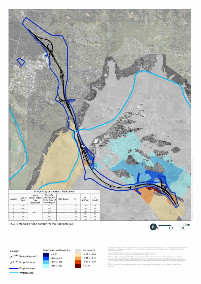
The flooding assessment considered the impact of the proposal to peak flood levels for a range of flood events. A summary of the impacts to the modelled peak flood level as a result of the operation of the proposal for each event is provided in Table 6-11. The impact to peak flood levels for the five and one per cent AEP events is shown in Figure 6-5 and Figure 6-6 respectively.
Flood modelling indicates that the proposal would increase and decrease the peak flood level in different locations. While the proposal would not substantially decrease peak flood levels in any location, the infrastructure for the proposal would provide an additional flood evacuation routes in the event of an early-warning flood evacuation for Singleton. The proposal would also improve local accessibility during a flood event.
Table 6-11: Impacts to modelled peak flood level
Flood event
Summary of impact
20% AEP No impact to modelled peak flood levels.
10% AEP Impacts are limited to minor and localised impacts at the Putty Road connection. Impacts to existing private property around the connection would be unlikely.
5% AEP Impacts would include an increase to the modelled peak flood levels at the Putty Road connection. It is unlikely that nearby dwellings would be impacted by more than a 0.02 metre increase in flood depths.
Reduced peak flood levels of 0.07 metres are anticipated through Glenridding.
2% AEP Impacts would include an increase in peak flood level extent and magnitude at the Putty Road connection compared to the five per cent AEP event. Peak flood levels at existing dwellings would be increased by around 0.04 meters.
Reduced peak flood levels of 0.06 metres are anticipated through Glenridding.
For this flood event, some localised flood impact is anticipated at the southern connection. However, the impacts are localised and limited to rural property, with no impact anticipated for existing dwellings.
1% AEP The flooding impact near the Putty Road connection and the southern connection generally increases in extent and magnitude with increased flood event rarity.
The modelled peak flood level impacts at dwelling locations remote from the bypass would be up to a 0.05 metre increase.
Reduced peak flood levels of 0.1 metres are anticipated through much of Singleton and Glenridding.
0.5% AEP The modelled peak flood level impacts at dwelling locations remote from the bypass would increase by up to 0.07 metres.
New England Highway bypass of Singleton Review of Environmental Factors
100

Flood event
Summary of impact
Reduced peak flood levels of 0.1 metres are anticipated through much of Singleton and Glenridding.
0.2% AEP Peak flood level impacts upstream of the southern connection are anticipated to increase by 0.5 metres. However, the impacts are localised and limited to rural property.
The modelled peak flood level impacts at dwelling locations remote from the bypass would be up to a 0.08 metre increase.
Reduced peak flood levels are anticipated through Glenridding but generally balanced through Singleton, with some localised reduction of up to around 0.1 metre.
New England Highway bypass of Singleton Review of Environmental Factors
101

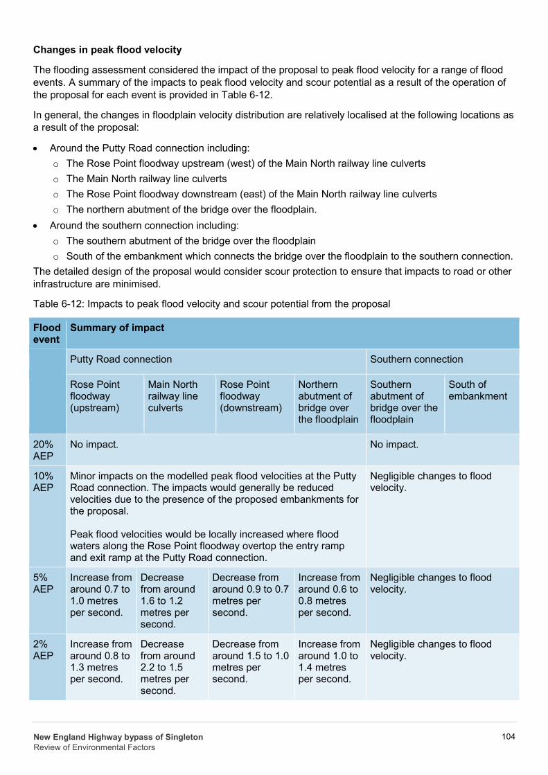
Changes in peak flood velocity
The flooding assessment considered the impact of the proposal to peak flood velocity for a range of flood events. A summary of the impacts to peak flood velocity and scour potential as a result of the operation of the proposal for each event is provided in Table 6-12.
In general, the changes in floodplain velocity distribution are relatively localised at the following locations as a result of the proposal:
• Around the Putty Road connection including: o The Rose Point floodway upstream (west) of the Main North railway line culverts o The Main North railway line culverts o The Rose Point floodway downstream (east) of the Main North railway line culverts o The northern abutment of the bridge over the floodplain.
• Around the southern connection including: o The southern abutment of the bridge over the floodplain o South of the embankment which connects the bridge over the floodplain to the southern connection.
The detailed design of the proposal would consider scour protection to ensure that impacts to road or other infrastructure are minimised.
Table 6-12: Impacts to peak flood velocity and scour potential from the proposal
Flood event
Summary of impact
Putty Road connection Southern connection
Rose Point floodway (upstream)
Main North railway line culverts
Rose Point floodway (downstream)
Northern abutment of bridge over the floodplain
Southern abutment of bridge over the floodplain
South of embankment
20% AEP
No impact. No impact.
10% AEP
Minor impacts on the modelled peak flood velocities at the Putty Road connection. The impacts would generally be reduced velocities due to the presence of the proposed embankments for the proposal.
Peak flood velocities would be locally increased where flood waters along the Rose Point floodway overtop the entry ramp and exit ramp at the Putty Road connection.
Negligible changes to flood velocity.
5% AEP
Increase from around 0.7 to 1.0 metres per second.
Decrease from around 1.6 to 1.2 metres per second.
Decrease from around 0.9 to 0.7 metres per second.
Increase from around 0.6 to 0.8 metres per second.
Negligible changes to flood velocity.
2% AEP
Increase from around 0.8 to 1.3 metres per second.
Decrease from around 2.2 to 1.5 metres per second.
Decrease from around 1.5 to 1.0 metres per second.
Increase from around 1.0 to 1.4 metres per second.
Negligible changes to flood velocity.
New England Highway bypass of Singleton Review of Environmental Factors
104
Flood event
Summary of impact
1% AEP
Increase from around 0.8 to 1.6 metres per second.
Decrease from around 2.6 to 2.0 metres per second.
Decrease from around 1.1 to 0.8 metres per second.
Increase from around 1.1 to 1.7 metres per second.
Increase from around 0.5 to 1.0 metres per second.
Localised increase from around 0.6 to 1.1 metres per second. General increase of around 0.4 to 0.6 metres per second.
0.5% AEP
Increase from around 0.9 to 1.7 metres per second.
Decrease from around 3.0 to 2.5 metres per second.
Decrease from around 1.8 to 1.2 metres per second.
Increase from around 1.3 to 2.1 metres per second.
Increase from 0.7 to 1.2 metres per second.
Increase from around 0.9 to 1.2 metres per second.
0.2% AEP
Increase from around 1.1 to 1.9 metres per second.
Decrease from around 3.6 to 3.0 metres per second.
Decrease from around 2.1 to 1.4 metres per second.
Increase from around 1.4 to 2.1 metres per second.
Increase from 1.1 to 1.6 metres per second.
Increase from around 1.2 to 1.4 metres per second.
6.2.4 Safeguards and management measures Mitigation measures provided in Table 6-13 would be implemented to minimise potential impacts to surface water and flooding.
Table 6-13: Summary of mitigation measures to minimise impacts to surface water and flooding
Impact Environmental safeguards Responsibility Timing
Surface water and flooding
A Soil and Water Management Plan will be prepared in accordance with QA Specification G38 and implemented as part of the CEMP. The Plan will identify all reasonably foreseeable risks relating to soil erosion and water pollution associated with undertaking the activity, and describe how these risks will be managed and minimised during construction. That will include arrangements for managing pollution risks associated with spillage or contamination on the site and adjoining areas, and monitoring during and post-construction.
Construction Contractor Pre-construction/co nstruction
Surface water and flooding
A flood response management plan will be prepared as part of the CEMP. The Flood Risk Management Plan will address, but not necessarily be limited to: • Processes for monitoring and mitigation
flood risk • Steps to be taken in the event of a
Construction contractor Construction
New England Highway bypass of Singleton Review of Environmental Factors
105
Impact Environmental safeguards Responsibility Timing
flood warning including removal or securing of loose material, equipment, fuels and chemicals.
Surface water and flooding
A site specific Erosion and Sediment Control Plan(s) will be prepared and implemented and included in the Soil and Water Management Plan. The Plan(s) will identify detailed measures and controls to be applied to minimise erosion and sediment control risks including, but not necessarily limited to: runoff, diversion and drainage points; sediment basins and sumps; scour protection; stabilising disturbed areas as soon as possible, check dams, fencing and swales; and staged implementation arrangements.
The Plan will also include arrangements for managing wet weather events, including monitoring of potential high risk events (such as storms) and specific controls and follow-up measures to be applied in the event of wet weather.
Construction Contractor Construction
Surface water and flooding
Stockpiles will be designed, established, operated and decommissioned in accordance with the RTA Stockpile Site Management Guideline 2011.
Construction Contractor Construction
Surface water and flooding
The rehabilitation of disturbed areas will be undertaken progressively as construction stages are completed, and in accordance with: • Landcom's Managing Urban
Stormwater: Soils and Construction series
• RTA Landscape Guideline • RMS Guideline for Batter Stabilisation
using Vegetation (2015)
Construction Contractor Construction
Surface water and flooding
Consistent with any specific requirements of the approved Soil and Water Management, control measures will be implemented to minimise risks associated with erosion and sedimentation and entry of materials to drainage lines and waterways. That will include, but not necessarily be limited to: • Sediment management devices, such
as fencing, hay bales or sand bags • Measures to divert or capture and filter
water prior to discharge, such as drainage channels and first flush and sediment basins
Construction Contractor Construction
New England Highway bypass of Singleton Review of Environmental Factors
106
Impact Environmental safeguards Responsibility Timing
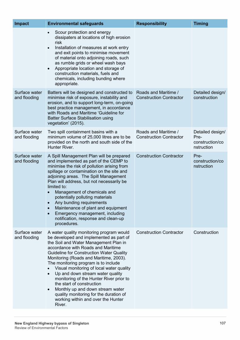
• Scour protection and energy dissipaters at locations of high erosion risk
• Installation of measures at work entry and exit points to minimise movement of material onto adjoining roads, such as rumble grids or wheel wash bays
• Appropriate location and storage of construction materials, fuels and chemicals, including bunding where appropriate.
Surface water and flooding
Batters will be designed and constructed to minimise risk of exposure, instability and erosion, and to support long-term, on-going best practice management, in accordance with Roads and Maritime ‘Guideline for Batter Surface Stabilisation using vegetation’ (2015).
Roads and Maritime / Construction Contractor
Detailed design/ construction
Surface water and flooding
Two spill containment basins with a minimum volume of 25,000 litres are to be provided on the north and south side of the Hunter River.
Roads and Maritime / Construction Contractor
Detailed design/ Pre-construction/co nstruction
Surface water and flooding
A Spill Management Plan will be prepared and implemented as part of the CEMP to minimise the risk of pollution arising from spillage or contamination on the site and adjoining areas. The Spill Management Plan will address, but not necessarily be limited to: • Management of chemicals and
potentially polluting materials • Any bunding requirements • Maintenance of plant and equipment • Emergency management, including
notification, response and clean-up procedures.
Construction Contractor Pre-construction/co nstruction
Surface water and flooding
A water quality monitoring program would be developed and implemented as part of the Soil and Water Management Plan in accordance with Roads and Maritime Guideline for Construction Water Quality Monitoring (Roads and Maritime, 2003). The monitoring program is to include • Visual monitoring of local water quality • Up and down stream water quality
monitoring of the Hunter River prior to the start of construction
• Monthly up and down stream water quality monitoring for the duration of working within and over the Hunter River.
Construction Contractor Construction
New England Highway bypass of Singleton Review of Environmental Factors
107

Impact Environmental safeguards Responsibility Timing
Surface water and flooding
Any dewatering activities will be undertaken in accordance with the RTA Technical Guideline: Environmental management of construction site dewatering in a manner that prevents pollution of waters.
Construction Contractor Detailed design/ Construction
New England Highway bypass of Singleton Review of Environmental Factors
108