Embed Size (px)
Citation preview
IdeaFest: Interdisciplinary Journal of Creative Works andResearch from Humboldt State UniversityVolume 2 ideaFest: Interdisciplinary Journal ofCreative Works and Research from Humboldt StateUniversity
Article 6
2018
Survey and Map Distribution of English Ivy(Hedera helix L.) at Patrick's Point State Park,CaliforniaJohn W. Cortenbach
Buddhika D. MadurapperumaHumboldt State University
Follow this and additional works at: https://digitalcommons.humboldt.edu/ideafest
Part of the Forest Management Commons, and the Other Forestry and Forest SciencesCommons
This Article is brought to you for free and open access by the Journals at Digital Commons @ Humboldt State University. It has been accepted forinclusion in IdeaFest: Interdisciplinary Journal of Creative Works and Research from Humboldt State University by an authorized editor of DigitalCommons @ Humboldt State University. For more information, please contact [email protected].
Recommended CitationCortenbach, John W. and Madurapperuma, Buddhika D. (2018) "Survey and Map Distribution of English Ivy (Hedera helix L.) atPatrick's Point State Park, California," IdeaFest: Interdisciplinary Journal of Creative Works and Research from Humboldt State University:Vol. 2 , Article 6.Available at: https://digitalcommons.humboldt.edu/ideafest/vol2/iss1/6
Survey and Map Distribution of English Ivy (Hedera helix L.) at Patrick'sPoint State Park, California
AcknowledgementsWe would like thank to Michelle Forys Environmentalist, North Coastal Redwoods District for sharing thespecies data within the park in previous years and George Pease, Stockroom Manager for providing theequipment for this research.
This article is available in IdeaFest: Interdisciplinary Journal of Creative Works and Research from Humboldt State University:https://digitalcommons.humboldt.edu/ideafest/vol2/iss1/6
ideaFest: Interdisciplinary Journal | Natural Sciences
34
Survey and Map Distribution of English Ivy (Hedera helix L.) at Patrick’s Point State Park, California
John Cortenbach1, Buddhika D. Madurapperuma2*
1Undergraduate Student, Departments of Forestry and Wildland Resources and Environmental Science and Management, Humboldt State University, Arcata, CA
2Lecturer/Research Associate, Departments of Forestry and Wildland Resources and Environmental Science and Manage-ment, Humboldt State University, Arcata, CA
*author correspondence: [email protected]
AbstrAct
Patrick’s Point State Park has experienced a tremendous growth of English ivy (Hedera helix L.) that is caus-ing damage to the park resources. The goal of this study was to accurately map English ivy habitats and estimate coverage and colonization effects on tree trunks within the park. The results showed that the English ivy growth has decreased from 8.0 acres to 6.5 acres between 2015 and 2016, respectively, due to park restoration activity supported by volunteer organizations. The English ivy growth on tree trunks was significant for western hemlock and Sitka spruce. With the completion of this project, the park will now be able to locate English ivy spots that require the most attention and monitor their growth rate.
introduction
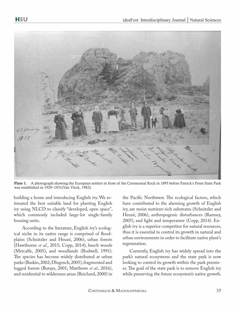
English ivy (Hedera helix L.) is an evergreen woody climber that produces adventitious roots to climb on a wide range of natural and artificial substrates (Melzer et al., 2011). English ivy was introduced to Patrick’s Point State Park in Trinidad, California. The plant is native to Northern Europe and was brought by Euro-pean settlers in the late 1890s as an ornamental plant before the park acquisition. English ivy was so im-portant to them that they wanted to maintain it for future generations. Patrick’s Point has a historical past from a group these settlers called “the Brooks” (Van Vleck, 1983). This information was documented by the Resource Agency California Department of Parks and Recreation (2016).
Understanding the historical landscape of Pat-rick’s Point State Park is important to assess how En-glish ivy was first introduced to the park by the Eu-
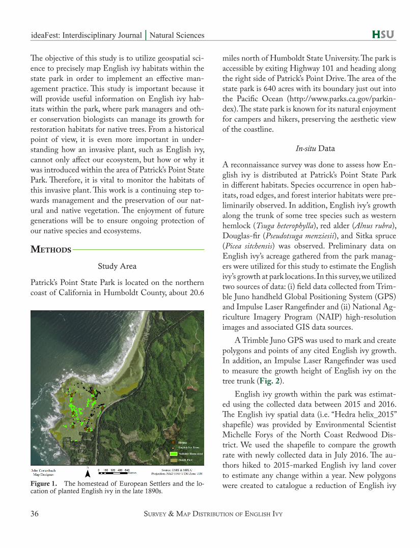
ropean settlers. Michelle Forys, a local environmental scientist, shared a photograph of the settlers in front of the Ceremonial Rock in 1895 (Plate 1; Van Vleck, 1983). The evidence of settlers living on the land shows the possibly of introducing English ivy to a new ecosystem. In this study, the potential homestead of the European settlers was modeled using the spread of English ivy growth by comparing the collection of point-marked data and the National Land Cover Da-tabase (NLCD, 2011) by the U.S. Geological Survey (USGS).
The potential homestead of the European settlers is useful to understand how English ivy was intro-duced into the ecosystem and the distance from the settler’s homestead. The results shown in Fig. 1 illus-trate that the trees growing in their beginning stage during the late 1890s show the location of where the English ivy was planted near the most suitable devel-oped open space. Thus, the European settlers grazed,
ideaFest: Interdisciplinary Journal | Natural Sciences
35
building a home and introducing English ivy. We es-timated the best suitable land for planting English ivy using NLCD to classify “developed, open space”, which commonly included large-lot single-family housing units.
According to the literature, English ivy’s ecolog-ical niche in its native range is comprised of flood-plains (Schnitzler and Heuzé, 2006), urban forests (Hawthorne et al., 2015; Copp, 2014), beech woods (Metcalfe, 2005), and woodlands (Rodwell, 1991). The species has become widely distributed at urban parks (Baskin, 2002; Dlugosch, 2005), fragmented and logged forests (Butaye, 2001; Matthews et al., 2016), and residential to wilderness areas (Reichard, 2000) in
the Pacific Northwest. The ecological factors, which have contributed to the alarming growth of English ivy, are moist nutrient-rich substrates (Schnitzler and Heuzé, 2006), anthropogenic disturbances (Ramsey, 2005), and light and temperature (Copp, 2014). En-glish ivy is a superior competitor for natural resources, thus it is essential to control its growth in natural and urban environments in order to facilitate native plant’s regeneration.
Currently, English ivy has widely spread into the park’s natural ecosystems and the state park is now looking to control its growth within the park premis-es. The goal of the state park is to remove English ivy while preserving the future ecosystem’s native growth.
Plate 1. A photograph showing the European settlers in front of the Ceremonial Rock in 1895 before Patrick’s Point State Park was established in 1929–1931(Van Vleck, 1983).
cortenbAcH & mAdUrApperUmA
ideaFest: Interdisciplinary Journal | Natural Sciences
36
The objective of this study is to utilize geospatial sci-ence to precisely map English ivy habitats within the state park in order to implement an effective man-agement practice. This study is important because it will provide useful information on English ivy hab-itats within the park, where park managers and oth-er conservation biologists can manage its growth for restoration habitats for native trees. From a historical point of view, it is even more important in under-standing how an invasive plant, such as English ivy, cannot only affect our ecosystem, but how or why it was introduced within the area of Patrick’s Point State Park. Therefore, it is vital to monitor the habitats of this invasive plant. This work is a continuing step to-wards management and the preservation of our nat-ural and native vegetation. The enjoyment of future generations will be to ensure ongoing protection of our native species and ecosystems.
methods
Study Area
Patrick’s Point State Park is located on the northern coast of California in Humboldt County, about 20.6
miles north of Humboldt State University. The park is accessible by exiting Highway 101 and heading along the right side of Patrick’s Point Drive. The area of the state park is 640 acres with its boundary just out into the Pacific Ocean (http://www.parks.ca.gov/parkin-dex). The state park is known for its natural enjoyment for campers and hikers, preserving the aesthetic view of the coastline.
In-situ Data
A reconnaissance survey was done to assess how En-glish ivy is distributed at Patrick’s Point State Park in different habitats. Species occurrence in open hab-itats, road edges, and forest interior habitats were pre-liminarily observed. In addition, English ivy’s growth along the trunk of some tree species such as western hemlock (Tsuga heterophylla), red alder (Alnus rubra), Douglas-fir (Pseudotsuga menziesii), and Sitka spruce (Picea sitchensis) was observed. Preliminary data on English ivy’s acreage gathered from the park manag-ers were utilized for this study to estimate the English ivy’s growth at park locations. In this survey, we utilized two sources of data: (i) field data collected from Trim-ble Juno handheld Global Positioning System (GPS) and Impulse Laser Rangefinder and (ii) National Ag-riculture Imagery Program (NAIP) high-resolution images and associated GIS data sources.
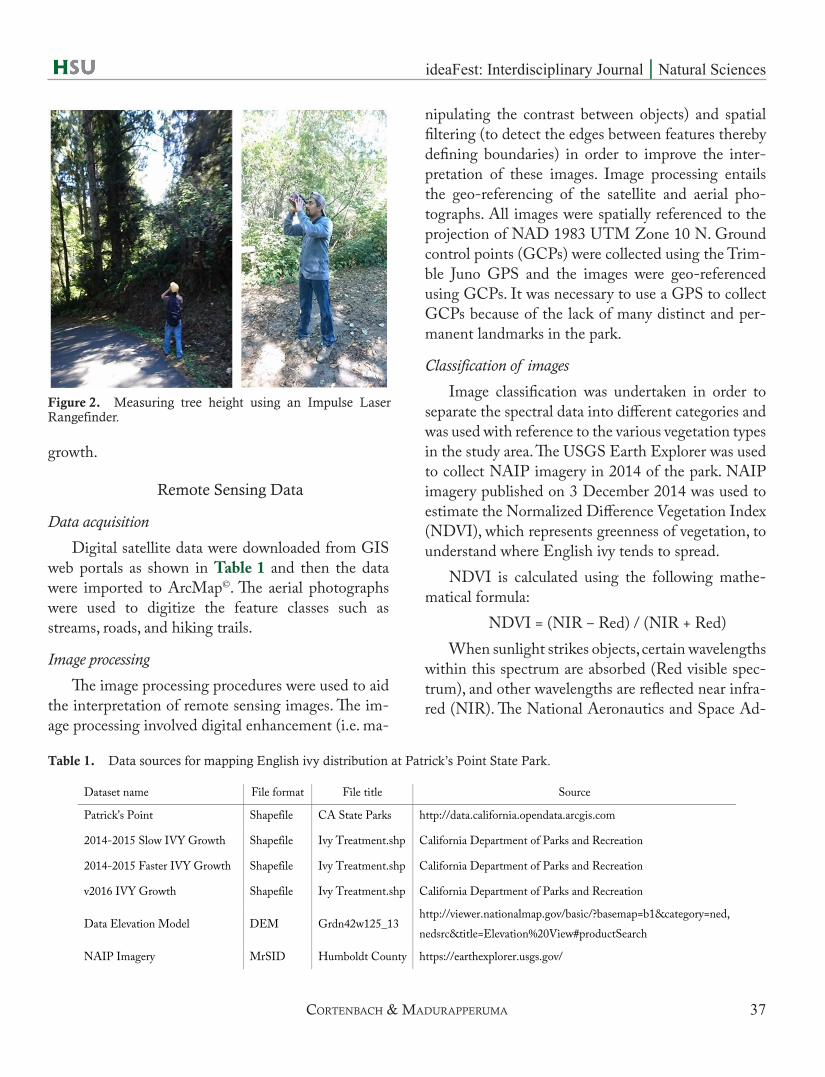
A Trimble Juno GPS was used to mark and create polygons and points of any cited English ivy growth. In addition, an Impulse Laser Rangefinder was used to measure the growth height of English ivy on the tree trunk (Fig. 2).
English ivy growth within the park was estimat-ed using the collected data between 2015 and 2016. The English ivy spatial data (i.e. “Hedra helix_2015” shapefile) was provided by Environmental Scientist Michelle Forys of the North Coast Redwood Dis-trict. We used the shapefile to compare the growth rate with newly collected data in July 2016. The au-thors hiked to 2015-marked English ivy land cover to estimate any change within a year. New polygons were created to catalogue a reduction of English ivy Figure 1. The homestead of European Settlers and the lo-
cation of planted English ivy in the late 1890s.
sUrVey & mAp distribUtion oF englisH iVy
ideaFest: Interdisciplinary Journal | Natural Sciences
37
growth.
Remote Sensing Data
Data acquisition
Digital satellite data were downloaded from GIS web portals as shown in Table 1 and then the data were imported to ArcMap©. The aerial photographs were used to digitize the feature classes such as streams, roads, and hiking trails.
Image processing
The image processing procedures were used to aid the interpretation of remote sensing images. The im-age processing involved digital enhancement (i.e. ma-
nipulating the contrast between objects) and spatial filtering (to detect the edges between features thereby defining boundaries) in order to improve the inter-pretation of these images. Image processing entails the geo-referencing of the satellite and aerial pho-tographs. All images were spatially referenced to the projection of NAD 1983 UTM Zone 10 N. Ground control points (GCPs) were collected using the Trim-ble Juno GPS and the images were geo-referenced using GCPs. It was necessary to use a GPS to collect GCPs because of the lack of many distinct and per-manent landmarks in the park.
Classification of images
Image classification was undertaken in order to separate the spectral data into different categories and was used with reference to the various vegetation types in the study area. The USGS Earth Explorer was used to collect NAIP imagery in 2014 of the park. NAIP imagery published on 3 December 2014 was used to estimate the Normalized Difference Vegetation Index (NDVI), which represents greenness of vegetation, to understand where English ivy tends to spread.
NDVI is calculated using the following mathe-matical formula:
NDVI = (NIR ‒ Red) / (NIR + Red)When sunlight strikes objects, certain wavelengths
within this spectrum are absorbed (Red visible spec-trum), and other wavelengths are reflected near infra-red (NIR). The National Aeronautics and Space Ad-
Figure 2. Measuring tree height using an Impulse Laser Rangefinder.
cortenbAcH & mAdUrApperUmA
Table 1. Data sources for mapping English ivy distribution at Patrick’s Point State Park.
Dataset name File format File title Source
Patrick’s Point Shapefile CA State Parks http://data.california.opendata.arcgis.com
2014-2015 Slow IVY Growth Shapefile Ivy Treatment.shp California Department of Parks and Recreation
2014-2015 Faster IVY Growth Shapefile Ivy Treatment.shp California Department of Parks and Recreation
v2016 IVY Growth Shapefile Ivy Treatment.shp California Department of Parks and Recreation
Data Elevation Model DEM Grdn42w125_13 http://viewer.nationalmap.gov/basic/?basemap=b1&category=ned, nedsrc&title=Elevation%20View#productSearch
NAIP Imagery MrSID Humboldt County https://earthexplorer.usgs.gov/
ideaFest: Interdisciplinary Journal | Natural Sciences
38
ministration (NASA) states, “pigment in plant leaves, chlorophyll, strongly absorbs visible light (from 0.4 to 0.7 µm) for use in photosynthesis. The cell struc-ture of the leaves, on the other hand, strongly reflects near-infrared light (from 0.7 to 1.1 µm)” (Weier and Herring, 2000). NDVI is an indication of the condi-tion of green vegetation with values typically ranging from −1 to +1, with values > 0.5 indicating dense veg-etation and values < 0 indicating bare ground.
Boundary determination
The potential homestead boundaries of Europe-an settlers in Patrick’s Point State Park were mapped using NLCD, a digital elevation model, and existing English ivy locations. NLCD represents land-use/cover classes, for example, classes 21–24 are catego-rized as “developed” areas. In ArcGIS© 10.2.2, the Raster Calculator was used to select cells (n = 21) that meet the criteria for “developed, open space”. The for-mula ““land_use_data” ==21” was entered to Raster Calculator to see the areas. The elevation, slope, and land cover data were used to locate the human-settled lands, where the land cover equals the selected cells
(n = 21) and the slope elevation. The European immi-grants lived in the highlighted areas where the land was flat to build a home and graze landscapes (Fig. 1).
Data analysis
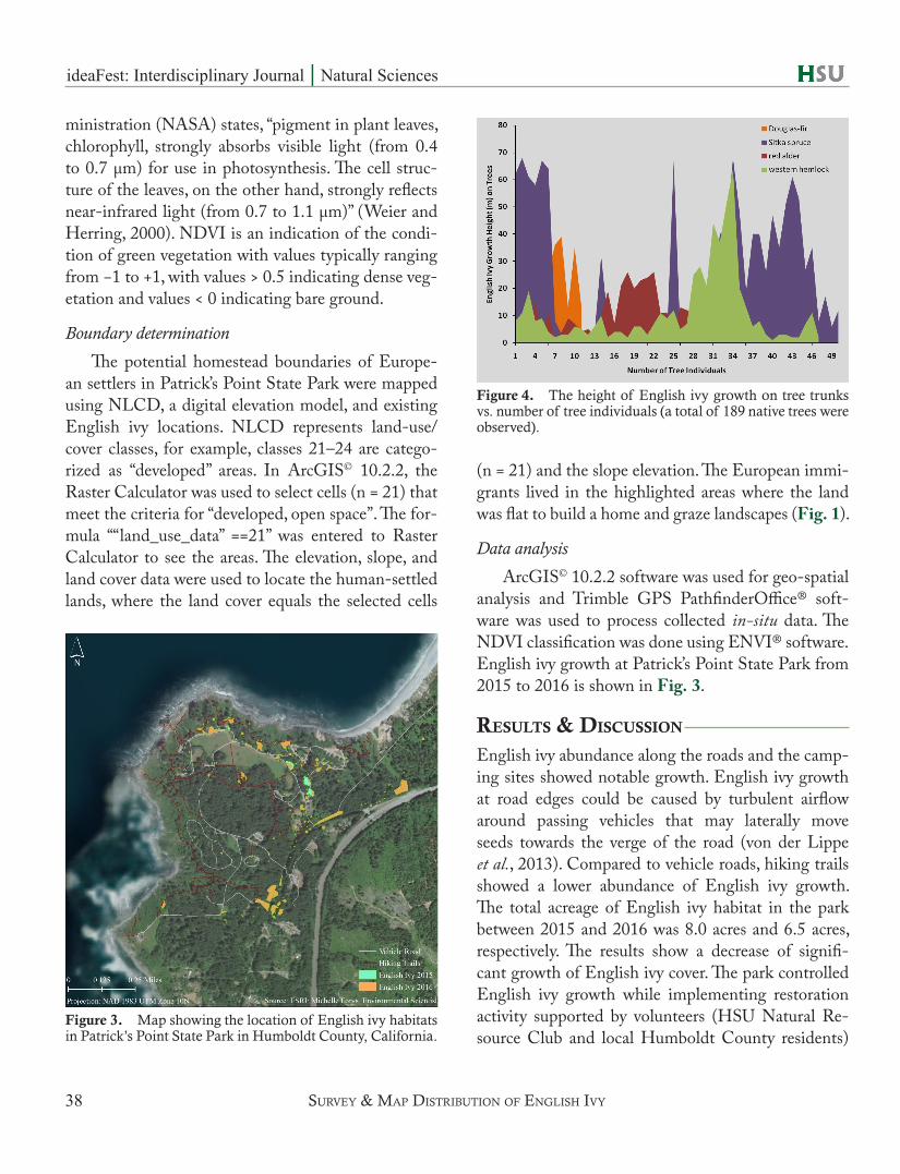
ArcGIS© 10.2.2 software was used for geo-spatial analysis and Trimble GPS PathfinderOffice® soft-ware was used to process collected in-situ data. The NDVI classification was done using ENVI® software.English ivy growth at Patrick’s Point State Park from 2015 to 2016 is shown in Fig. 3.
results & discussion
English ivy abundance along the roads and the camp-ing sites showed notable growth. English ivy growth at road edges could be caused by turbulent airflow around passing vehicles that may laterally move seeds towards the verge of the road (von der Lippe et al., 2013). Compared to vehicle roads, hiking trails showed a lower abundance of English ivy growth. The total acreage of English ivy habitat in the park between 2015 and 2016 was 8.0 acres and 6.5 acres, respectively. The results show a decrease of signifi-cant growth of English ivy cover. The park controlled English ivy growth while implementing restoration activity supported by volunteers (HSU Natural Re-source Club and local Humboldt County residents)
Figure 3. Map showing the location of English ivy habitats in Patrick’s Point State Park in Humboldt County, California.
Figure 4. The height of English ivy growth on tree trunks vs. number of tree individuals (a total of 189 native trees were observed).
sUrVey & mAp distribUtion oF englisH iVy

ideaFest: Interdisciplinary Journal | Natural Sciences
39
and the California Conservation Corp.In relation to a steady decline of English ivy
habitat, however, native tree species such as western hemlock, red alder, Douglas-fir, and Sitka spruce are significantly invaded by English ivy growth. The se-lection of native trees estimated as the most impacted by English ivy growth are shown in Fig. 4. The impact levels were measured by how many trees in each spe-cies were invaded by English ivy and how far the ivy grew along the tree trunk. The estimated result shows that both Sitka spruce and western hemlock trees are significantly impacted by English ivy (Fig. 4). The reason why English ivy grows on these specific native trees is questionable, and their impact on trees’ health needs to be investigated. However, previous studies on bark characteristics of host plants suggested that rough bark is more favorable for English ivy growth, protecting it from herbivore browsing (Hegarty and Caballe, 1991; Schnitzler and Heuzé, 2006). The bark characteristics may facilitate higher abundance of English ivy on tree trunks of Sitka spruce due to the prevalence of moisture and dust particles in flaky bark. Furthermore, Environmental Scientist Forys
stated that allowing English ivy to grow around the bark of the tree creates competitive struggle between the English ivy and the tree for nutrients, water, and sunlight. By creating competition for the tree resourc-es, English ivy can make a tree weaker (Schnitzler and Heuzé, 2006). This study is only based on the growth condition of English ivy, however, this can lead to fu-ture research on how physical and chemical charac-teristics of tree species enhance English ivy growth on the tree trunk. Sitka spruce is the most impacted tree, with the highest total count of English ivy growth (50 individuals) followed by western hemlock (47 individ-uals) and red alder (30 individuals). Douglas-fir was the least-recorded species (11 individuals) for En-glish ivy growth (Fig. 4). Table 2 shows the statistical growth rates and the ratio of the English ivy growth height based on the tree height measurement, while Table 3 shows site-specific English ivy growth. En-glish ivy growth along Point Drive Road and Abalone Campground is shown in Figs. 5 and 6.
The results in Fig. 7 suggest that English ivy shows a faster growth rate in a healthier-vegetation environment with high visible sunlight. In a low vege-tation-density environment, sunlight is more accessi-
Plant Ivy average height (m) Ivy range (min–max) (m) Tree average height (m) Tree range (min–max) (m)
Red alder 11.17 ± 7.40 1 – 26 20.97 ± 10.53 7 – 42 Sitka spruce 25.78 ± 23.34 1 – 68 55.42 ± 22.77 7 – 105 Douglas-fir 26.64 ± 9.69 13 – 39 41.00 ± 3.07 35 – 45 Western hemlock 10.91 ± 12.34 1 – 51 44.79 ± 14.83 7 – 75
Table 2. Estimates of the most significantly impacted native trees by English ivy growth based on measuring both the height of the tree and the height of English ivy shown in Fig. 3.
Figure 5. Marking data of Sitka spruce trees with English ivy growth along Point Drive Road.
Figure 6. English ivy growth at Abalone Campground.
cortenbAcH & mAdUrApperUmA
ideaFest: Interdisciplinary Journal | Natural Sciences
40
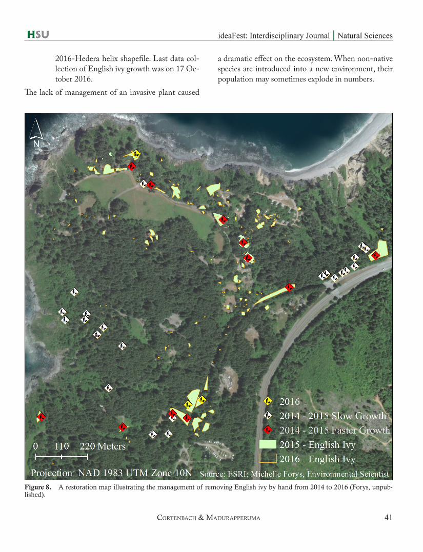
ble to native growth. This can lead to further issues in-volving English ivy growth control. It will continue to spread from its current growth location until this plant gains access to sunlight. To determine the density of healthy vegetation on a patch of land, NDVI is useful to observe the ratio between absorption of visible light (Red) and reflection of near-infrared (NIR) sunlight by plants. As shown in Fig. 7, the NDVI ranged from 0 – 0.59, and the English ivy occurrence was notice-able at the forest fringe, open campground, and the
intact forest (Figs. 7 and 8). English ivy seeds are dis-persed by birds from the tree trunk to the canopy gap area of intact forest (Soll, 2005). Seeds produced over 60 meters high on tree trunks enhance seed disper-sal through seashore birds (e.g. Steller’s Jay) that can potentially colonize in new habitats (Sulgrove, 2004; Swearingen and Diedrich, 2006). Therefore, con-trolling English ivy growth on the tree trunk before its flowering season is important in order to reduce the dispersal distance of seeds before they colonize in new habitats.
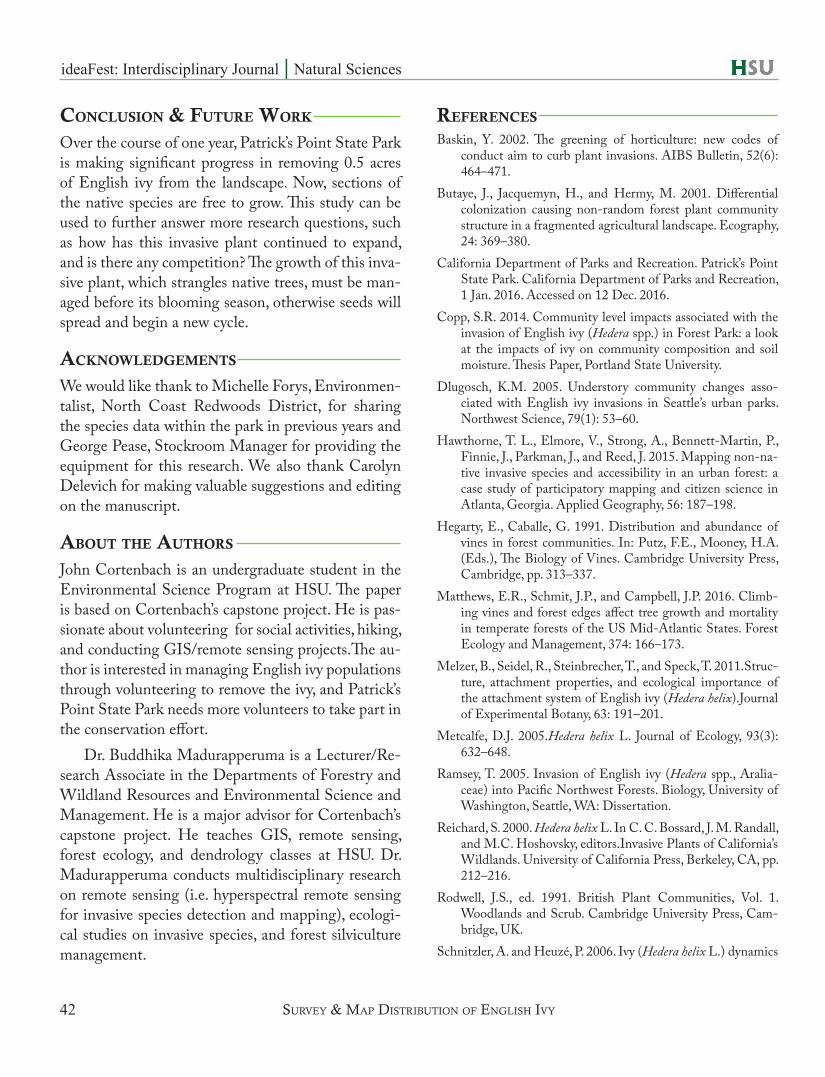
The invasive plant’s growth rate based on the park management schedule of removing it once per month is shown in Fig. 8. The park announces restoration activities for volunteers and the support of California Conservation Corps throughout each season (winter, spring, and fall), except summer. The reason why sum-mer is not added to their schedule is because most of the support from Humboldt State students and club members from the HSU Natural Resource Club are on vacation. This map allows the state park to manage their time and resources more sufficiently.
Markers illustrated in the legend correspond to the following:
White marker: 2014 – 2015 Slow Growth• English ivy showed a minor increase of
growth from 2014 and had not expanded significantly, resulting in less restoration ac-tivity within that certain area based on the measurements from shapefiles 2015-Hedera helix and 2016-Hedera helix.
Red marker: 2014 – 2015 Faster Growth• English ivy land cover showed a significant
increase in growth from 2014 to 2015 and had not decreased from constant resto-ration activity. Based on the measurements from shapefiles 2015-Hedera helix and 2016-Hedera helix.
Yellow marker: 2016 • Current English ivy restoration remov-
al a month after the last data collection in
Figure 7. NDVI map of Patrick’s Point State Park analyz-ing the density of plant growth of the state park using NAIP imagery 2014. This shows the ecological vegetation of pos-sible access to sunlight. The greens indicate healthy closed vegetation, the reds indicate unhealthy, scarce vegetation or water, and the yellows indicate neutral vegetation. English ivy flourishes for sunlight visibility based on its location.
sUrVey & mAp distribUtion oF englisH iVy
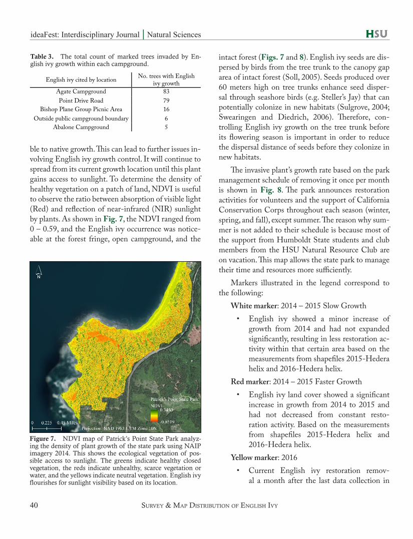
Table 3. The total count of marked trees invaded by En-glish ivy growth within each campground.
English ivy cited by location No. trees with English ivy growth
Agate Campground 83 Point Drive Road 79
Bishop Plane Group Picnic Area 16 Outside public campground boundary 6
Abalone Campground 5
ideaFest: Interdisciplinary Journal | Natural Sciences
41
2016-Hedera helix shapefile. Last data col-lection of English ivy growth was on 17 Oc-tober 2016.
The lack of management of an invasive plant caused
a dramatic effect on the ecosystem. When non-native species are introduced into a new environment, their population may sometimes explode in numbers.
Figure 8. A restoration map illustrating the management of removing English ivy by hand from 2014 to 2016 (Forys, unpub-lished).
cortenbAcH & mAdUrApperUmA
ideaFest: Interdisciplinary Journal | Natural Sciences
42
conclusion & Future work
Over the course of one year, Patrick’s Point State Park is making significant progress in removing 0.5 acres of English ivy from the landscape. Now, sections of the native species are free to grow. This study can be used to further answer more research questions, such as how has this invasive plant continued to expand, and is there any competition? The growth of this inva-sive plant, which strangles native trees, must be man-aged before its blooming season, otherwise seeds will spread and begin a new cycle.
Acknowledgements
We would like thank to Michelle Forys, Environmen-talist, North Coast Redwoods District, for sharing the species data within the park in previous years and George Pease, Stockroom Manager for providing the equipment for this research. We also thank Carolyn Delevich for making valuable suggestions and editing on the manuscript.
About the Authors
John Cortenbach is an undergraduate student in the Environmental Science Program at HSU. The paper is based on Cortenbach’s capstone project. He is pas-sionate about volunteering for social activities, hiking, and conducting GIS/remote sensing projects.The au-thor is interested in managing English ivy populations through volunteering to remove the ivy, and Patrick’s Point State Park needs more volunteers to take part in the conservation effort.
Dr. Buddhika Madurapperuma is a Lecturer/Re-search Associate in the Departments of Forestry and Wildland Resources and Environmental Science and Management. He is a major advisor for Cortenbach’s capstone project. He teaches GIS, remote sensing, forest ecology, and dendrology classes at HSU. Dr. Madurapperuma conducts multidisciplinary research on remote sensing (i.e. hyperspectral remote sensing for invasive species detection and mapping), ecologi-cal studies on invasive species, and forest silviculture management.
reFerences
Baskin, Y. 2002. The greening of horticulture: new codes of conduct aim to curb plant invasions. AIBS Bulletin, 52(6): 464–471.
Butaye, J., Jacquemyn, H., and Hermy, M. 2001. Differential colonization causing non-random forest plant community structure in a fragmented agricultural landscape. Ecography, 24: 369–380.
California Department of Parks and Recreation. Patrick’s Point State Park. California Department of Parks and Recreation, 1 Jan. 2016. Accessed on 12 Dec. 2016.
Copp, S.R. 2014. Community level impacts associated with the invasion of English ivy (Hedera spp.) in Forest Park: a look at the impacts of ivy on community composition and soil moisture. Thesis Paper, Portland State University.
Dlugosch, K.M. 2005. Understory community changes asso-ciated with English ivy invasions in Seattle’s urban parks. Northwest Science, 79(1): 53–60.
Hawthorne, T. L., Elmore, V., Strong, A., Bennett-Martin, P., Finnie, J., Parkman, J., and Reed, J. 2015. Mapping non-na-tive invasive species and accessibility in an urban forest: a case study of participatory mapping and citizen science in Atlanta, Georgia. Applied Geography, 56: 187–198.
Hegarty, E., Caballe, G. 1991. Distribution and abundance of vines in forest communities. In: Putz, F.E., Mooney, H.A. (Eds.), The Biology of Vines. Cambridge University Press, Cambridge, pp. 313–337.
Matthews, E.R., Schmit, J.P., and Campbell, J.P. 2016. Climb-ing vines and forest edges affect tree growth and mortality in temperate forests of the US Mid-Atlantic States. Forest Ecology and Management, 374: 166–173.
Melzer, B., Seidel, R., Steinbrecher, T., and Speck, T. 2011.Struc-ture, attachment properties, and ecological importance of the attachment system of English ivy (Hedera helix).Journal of Experimental Botany, 63: 191–201.
Metcalfe, D.J. 2005.Hedera helix L. Journal of Ecology, 93(3): 632–648.
Ramsey, T. 2005. Invasion of English ivy (Hedera spp., Aralia-ceae) into Pacific Northwest Forests. Biology, University of Washington, Seattle, WA: Dissertation.
Reichard, S. 2000. Hedera helix L. In C. C. Bossard, J. M. Randall, and M.C. Hoshovsky, editors.Invasive Plants of California’s Wildlands. University of California Press, Berkeley, CA, pp. 212–216.
Rodwell, J.S., ed. 1991. British Plant Communities, Vol. 1. Woodlands and Scrub. Cambridge University Press, Cam-bridge, UK.
Schnitzler, A. and Heuzé, P. 2006. Ivy (Hedera helix L.) dynamics
sUrVey & mAp distribUtion oF englisH iVy
ideaFest: Interdisciplinary Journal | Natural Sciences
43
in riverine forests: effects of river regulation and forest dis-turbance. Forest Ecology and Management, 236(1): 12–17.
Soll, Jonathan. 2005. Controlling English ivy (Hedera helix) in the Pacific Northwest, [Online]. In: Control methods--In-vasive plant management. In: GIST (Global Invasive Spe-cies Team). Arlington, VA: The Nature Conservancy (Pro-ducer). Available: http://www.invasive.org/gist/moredocs/hedhel02.pdf [2018, April 2].
Sulgrove, S.M. 2004. Is Ivy Invasive? What known about Ivy. Ivy Journal, The American Ivy Society, 30: 16–17.
Swearingen, J.M.,Diedrich, S. 2006. Fact sheet: English ivy--Hedera helix L., [Online]. In: Weeds gone wild: Alien plant invaders of natural areas--Fact sheets. Plant Conserva-
tion Alliance’s Alien Plant Working Group (Producer).Van Vleck, 1983. Patrick’s Point State Park preliminary General
Plan. State of California - The Resources Agency, Depart-ment of Parks and Recreation, 1–54.
von der Lippe, M., Bullock, J.M., Kowarik, I., Knopp, T., Wichmann, M. 2013. Correction: human-mediated dis-persal of seeds by the airflow of vehicles. PLoS ONE 8(8): 10.1371/annotation/50f98e02-214c-4314-b053-ca-272101ead1. https://doi.org/10.1371/annota-tion/50f98e02-214c-4314-b053-ca272101ead1
Weier, J. and Herring, D. 2000.Measuring vegetation (NDVI & EVI).NASA Earth Observatory, Washington DC.
cortenbAcH & mAdUrApperUmA