Embed Size (px)
Citation preview
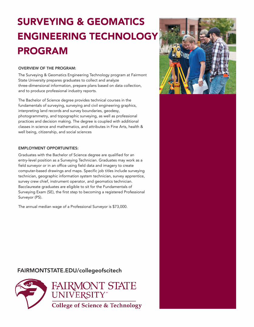
OVERVIEW OF THE PROGRAM:
The Surveying & Geomatics Engineering Technology program at Fairmont State University prepares graduates to collect and analyze three-dimensional information, prepare plans based on data collection, and to produce professional industry reports.
The Bachelor of Science degree provides technical courses in the fundamentals of surveying, surveying and civil engineering graphics, interpreting land records and survey boundaries, geodesy, photogrammetry, and topographic surveying, as well as professional practices and decision making. The degree is coupled with additional classes in science and mathematics, and attributes in Fine Arts, health & well being, citizenship, and social sciences
EMPLOYMENT OPPORTUNITIES:
Graduates with the Bachelor of Science degree are qualified for an entry-level position as a Surveying Technician. Graduates may work as a field surveyor or in an office using field data and imagery to create computer-based drawings and maps. Specific job tit les include surveying technician, geographic information system technician, survey apprentice, survey crew chief, instrument operator, and geomatics technician. Bacclaureate graduates are eligible to sit for the Fundamentals of Surveying Exam (SE), the first step to becoming a registered Professional Surveyor (PS).
The annual median wage of a Professional Surveyor is $73,000.
SURVEYING & GEOMATICS
ENGINEERING TECHNOLOGY
PROGRAM
FAIRMONTSTATE.EDU/collegeofscitech
SURVEYING & GEOMATICS ENGINEERING TECHNOLOGY PROGRAM
3
15
Tabitha Lafferre, E.I.
Surveying & Geomatics Engineering Technology
Department of Engineering Technology
418 Engineering Technology
Phone: (304) 367-4631
Fairmont State University is an Equal Opportunity, Affirmative Action Institution.
6/21:
FAIRMONTSTATE.EDU/collegeofscitech
CONTACT INFORMATION
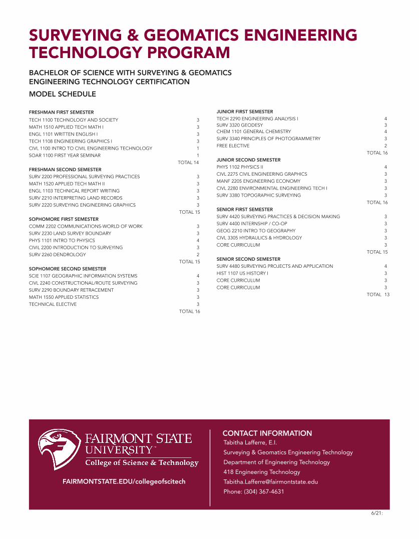
FRESHMAN FIRST SEMESTER
TECH 1100 TECHNOLOGY AND SOCIETY 3
MATH 1510 APPLIED TECH MATH I 3
ENGL 1101 WRITTEN ENGLISH I 3
TECH 1108 ENGINEERING GRAPHICS I 3
CIVL 1100 INTRO TO CIVIL ENGINEERING TECHNOLOGY 1
SOAR 1100 FIRST YEAR SEMINAR 1
TOTAL 14
FRESHMAN SECOND SEMESTER
SURV 2200 PROFESSIONAL SURVEYING PRACTICES 3
MATH 1520 APPLIED TECH MATH II 3
ENGL 1103 TECHNICAL REPORT WRITING 3
SURV 2210 INTERPRETING LAND RECORDS 3
SURV 2220 SURVEYING ENGINEERING GRAPHICS 3
TOTAL 15
SOPHOMORE FIRST SEMESTER
COMM 2202 COMMUNICATIONS-WORLD OF WORK 3
SURV 2230 LAND SURVEY BOUNDARY 3
PHYS 1101 INTRO TO PHYSICS 4
CIVIL 2200 INTRODUCTION TO SURVEYING 3
SURV 2260 DENDROLOGY 2
TOTAL 15
SOPHOMORE SECOND SEMESTER
SCIE 1107 GEOGRAPHIC INFORMATION SYSTEMS 4
CIVL 2240 CONSTRUCTIONAL/ROUTE SURVEYING 3
SURV 2290 BOUNDARY RETRACEMENT 3
MATH 1550 APPLIED STATISTICS 3
TECHNICAL ELECTIVE 3
TOTAL 16
JUNIOR FIRST SEMESTER
TECH 2290 ENGINEERING ANALYSIS I 4SURV 3320 GEODESY 3CHEM 1101 GENERAL CHEMISTRY 4
SURV 3340 PRINCIPLES OF PHOTOGRAMMETRY 3
FREE ELECTIVE 2
TOTAL 16
JUNIOR SECOND SEMESTER
PHYS 1102 PHYSICS II 4
CIVL 2275 CIVIL ENGINEERING GRAPHICS 3
MANF 2205 ENGINEERING ECONOMY 3
CIVL 2280 ENVIRONMENTAL ENGINEERING TECH I 3
SURV 3380 TOPOGRAPHIC SURVEYING 3
TOTAL 16
SENIOR FIRST SEMESTER
SURV 4420 SURVEYING PRACTICES & DECISION MAKING 3
SURV 4400 INTERNSHIP / CO-OP 3
GEOG 2210 INTRO TO GEOGRAPHY 3
CIVL 3305 HYDRAULICS & HYDROLOGY 3
CORE CURRICULUM 3
TOTAL 15
SENIOR SECOND SEMESTER
SURV 4480 SURVEYING PROJECTS AND APPLICATION 4
HIST 1107 US HISTORY I 3
CORE CURRICULUM 3
CORE CURRICULUM 3
TOTAL 13
BACHELOR OF SCIENCE WITH SURVEYING & GEOMATICSENGINEERING TECHNOLOGY CERTIFICATION
MODEL SCHEDULE