Embed Size (px)
Citation preview
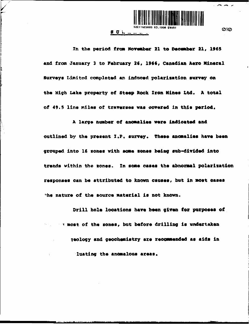
5aE11NE9«69 63.1996 EWART010
In the period tram November 21 to December 21, 1»65
and from January 3 to February 26, 196 f, Canadian A*ro Mineral
Surveys Limited completed an induced polarisation survey on
the High Lake property of Steep Rock Iron Mines Ltd. A total
of 49.5 line milt** of traverses was covered in this period.
A large numb«r of anoaali** wor« indioatad and
outlined by tha prasant I.P. survey. Thasa anomalies have been
grouped into 16 cones with some sones being sub-divided into
trends within the sones. Zn some eases the abnormal polarisation
responses can be attributed to known causes, but in nost eases
vhe nature of the source material is not known.
Drill hole locations have been given for purposes of
^ most of the sones, but before drilling is undertaken
geology and geochemistry are recommended as aids in
luating the anomalous areas.
REPORT ON INDUCED POtARlgAfYON SDRVEY
-_-.EWART 'OWlP, ONAiRIO
STEEP ROCK TTOff MINES LTD.
In the period from November 21 to December 21, 1965 and
from January 3 to February 26, 1966, an induced polarization survey
was carried out by Canadian Aero Mineral Surveys Limited on the
liicjh Lake property, Kw&rt Township in north-western Ontario on
hcthalf of Lteep Rock Iron Mines Limited, A total of 1375
observations were made for a coverage of 49.5 line* miles including
some detailing.
The High Lake property consists of 67 claims, a list of
vhich is attached to this report as Appendix 1, The layout of the
clains group is indicated on the plan maps showing the apparent
chargeabilities in contoured form.
The purpose of the induced polarization survey was to
map tho sub-surface distribution of metallic sulphide mineralization
in order to localize the presence of any copper deposits.
A reprint of the paper entitled "A Decade of
Development in Overvoltage Surveying" by Robert W. Baldwin, which
is attached to thla report describes the phenomena involved
and the methods of iseasuronent and interpretation of this type of
survey. For the preeent survey, high sensitivity, D.C. pulse-type
equipment was employed with a current on-time of 1.5 seconds and
a measuring time of 0.5 seconds.
- 2 -
At each observation point both the primary and
secondary voltages are measured. The primary voltages (steady
state voltagee) are converted by formula to apparent resistivities
in units of ohro meters. The secondary voltages (polarization
voltages) are measured by integration and then divided by the
corresponding primary voltages to obtain the apparent "charges-
bility", the resulting polarization property characteristic of
the region measured. It is expressed in units of milliseconds or
millivolt seconds per volt.
The chief application of induced polarization is in
the direct detection of disseminated metallic sulphides, however,
any transition in conduction front ionic to electronic and vice
versa will give rise to IF effects. For this reason all metallic
conducting sulphides, including pyrite, pyrrhotite, chalcopyrite
and chalcocite, etc. and arsenides will be detectable as well as
graphite. The latter may be expected to occur primarily in
carbonaceous shales and limestones. Occasionally abnormal IP
effects may be experienced fzom magnetite concentrations and from
serpentines. There is no way at present in which IP effects frora
*riy one of theee sources can be differentiated from those arising
from any of the others using the IP data alone.
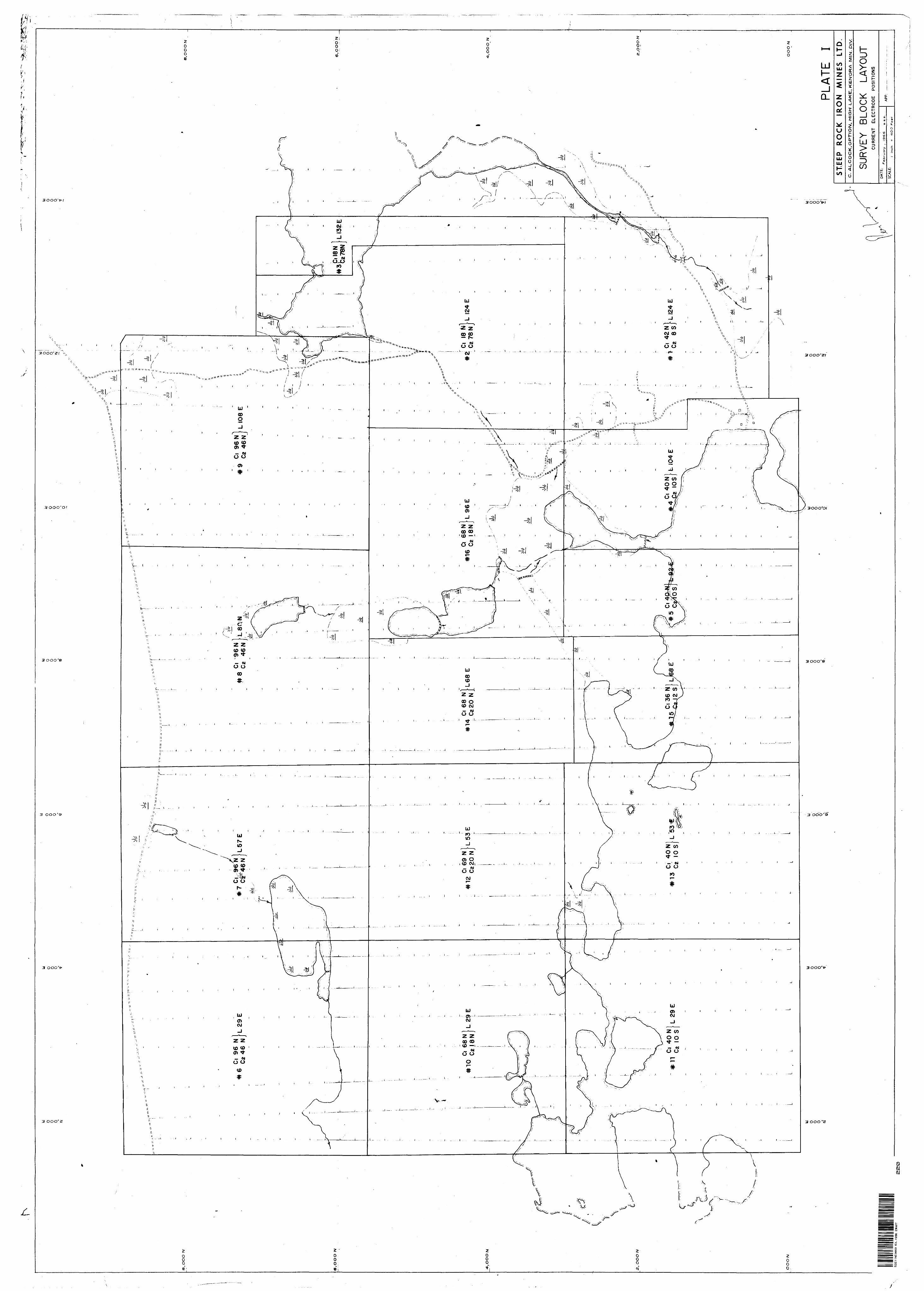
The gradient array electrode configuration was used
throughout the survey employing a potential electrode separation
of 200 feet for the reconnaissance work. As a means of detailing
certain anomalies a potential electrode spacing of 100 feet war
employed at times. The current electrode separation and positioning

- 3 -
as* well as the survey block layout, are indicated on Plate 1 at
a scale of 1" « 400 ft,
A high degree of masking is common in many areas
including the Precarobrian Shield where good conducting soils
overlie highly resistive bedrock. Under such conditions using
any of the usual arrays (two-electrode, three-electrode), the
electrode spacing must be many times larger than the depth of
overburden before the apparent resistivities and chargeabilities
become reasonably representative of the bedrock. Kith such large
i pacing a, one its effectively averaging the physical properties over
such a large volume of rock that the ability to detect the presence
of moderate sized bodies of mineralization is lost.
Under the same set of conditions, the Gradient Array
is both feasible and desirable. It reduces the effect of masking,
retains a high degree of resolution for small bodies, has good
depth penetration and offers certain practical operational
advantages.
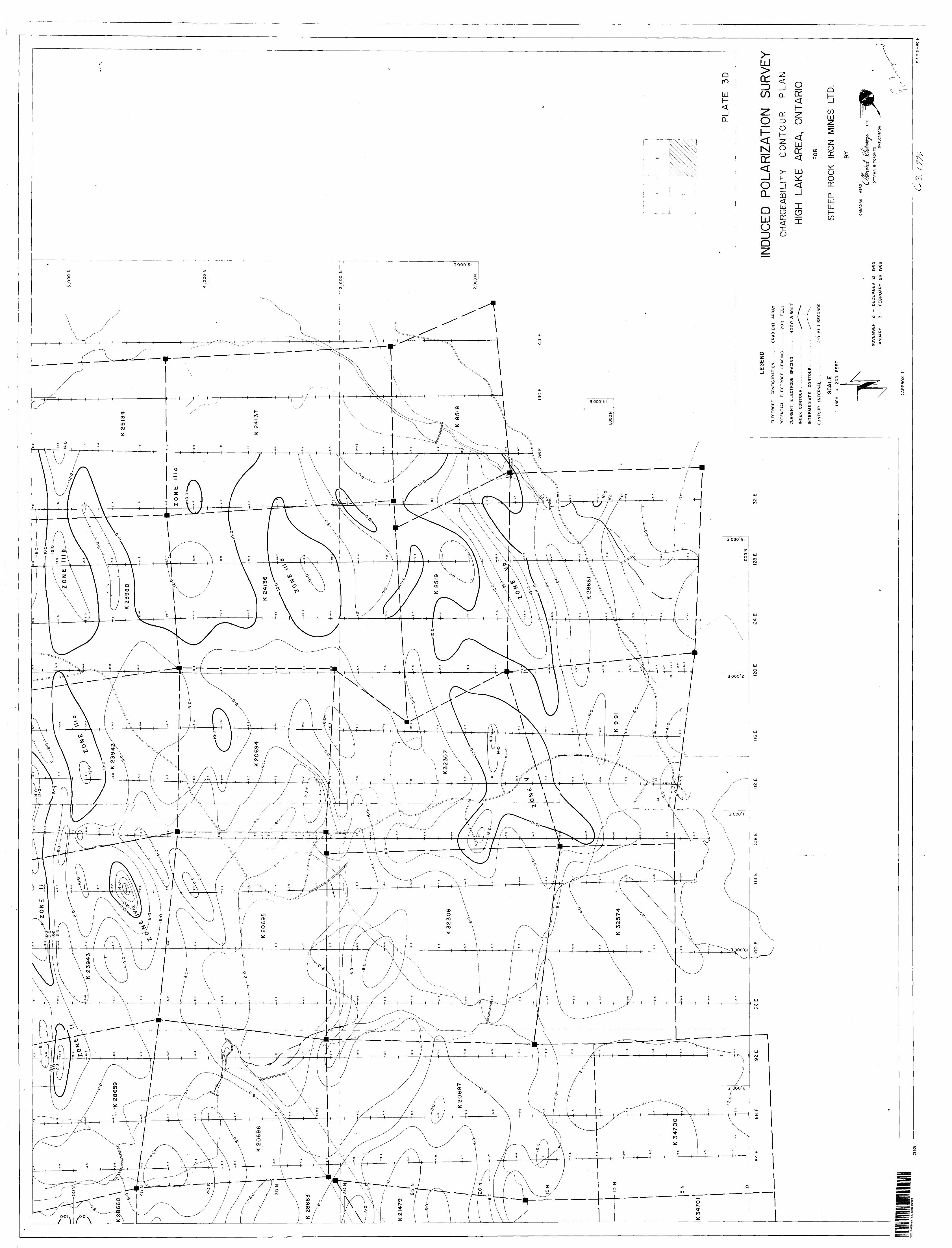
II. DISCUSSION OF RESULTS
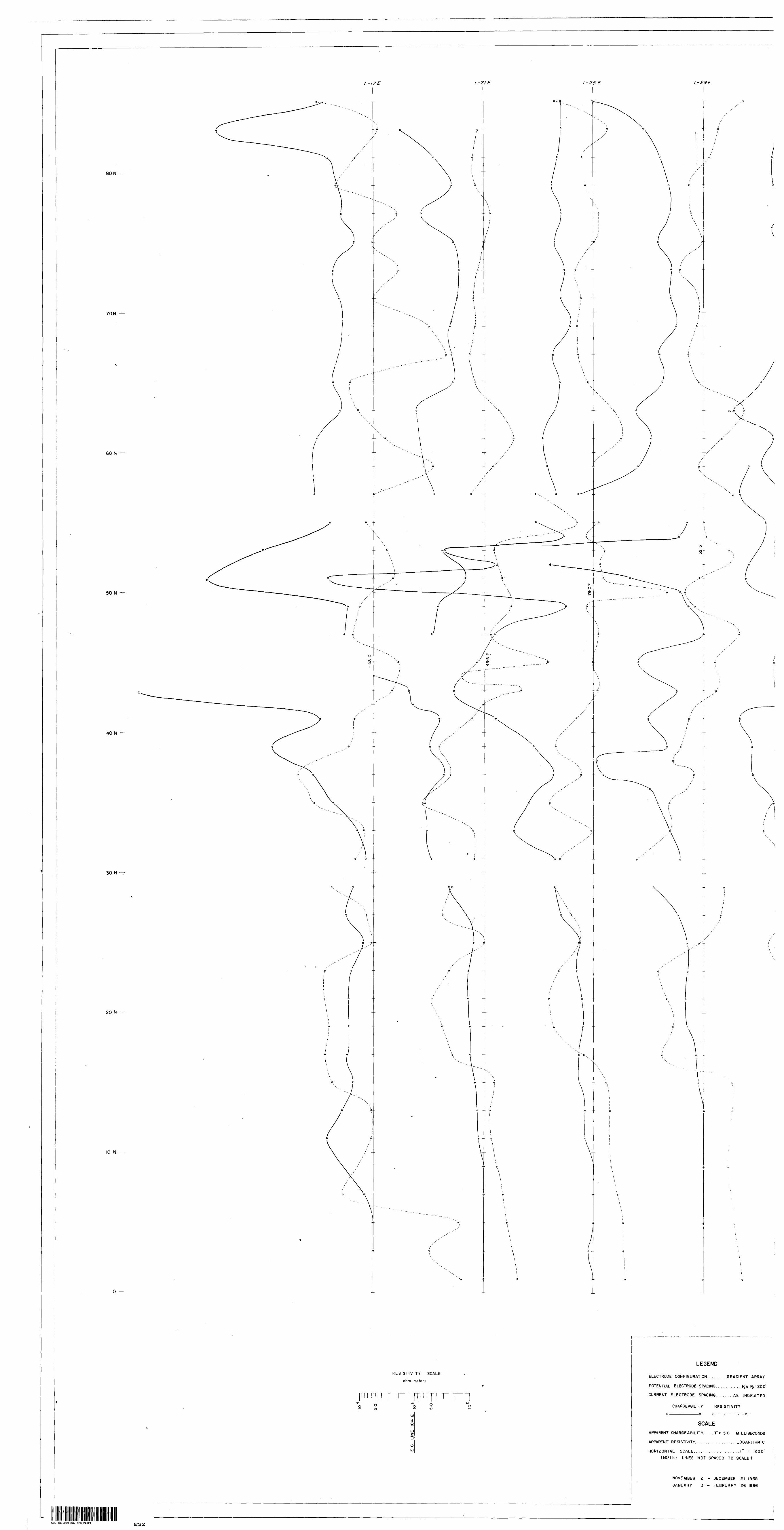
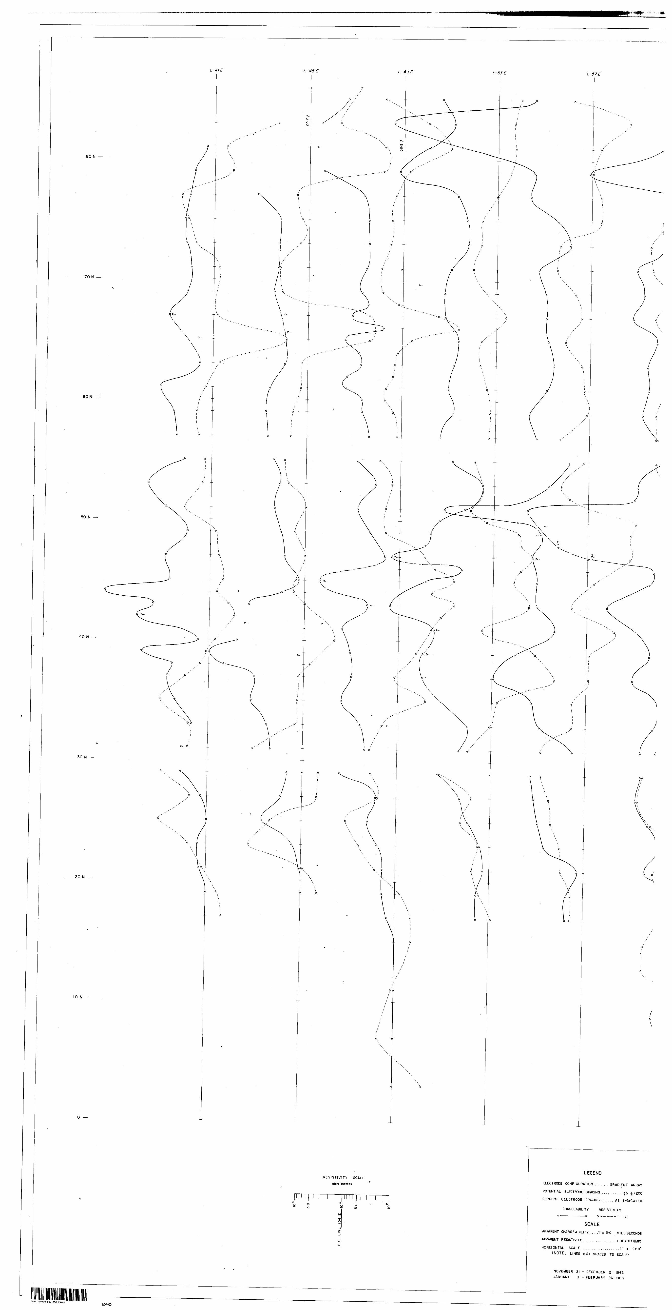
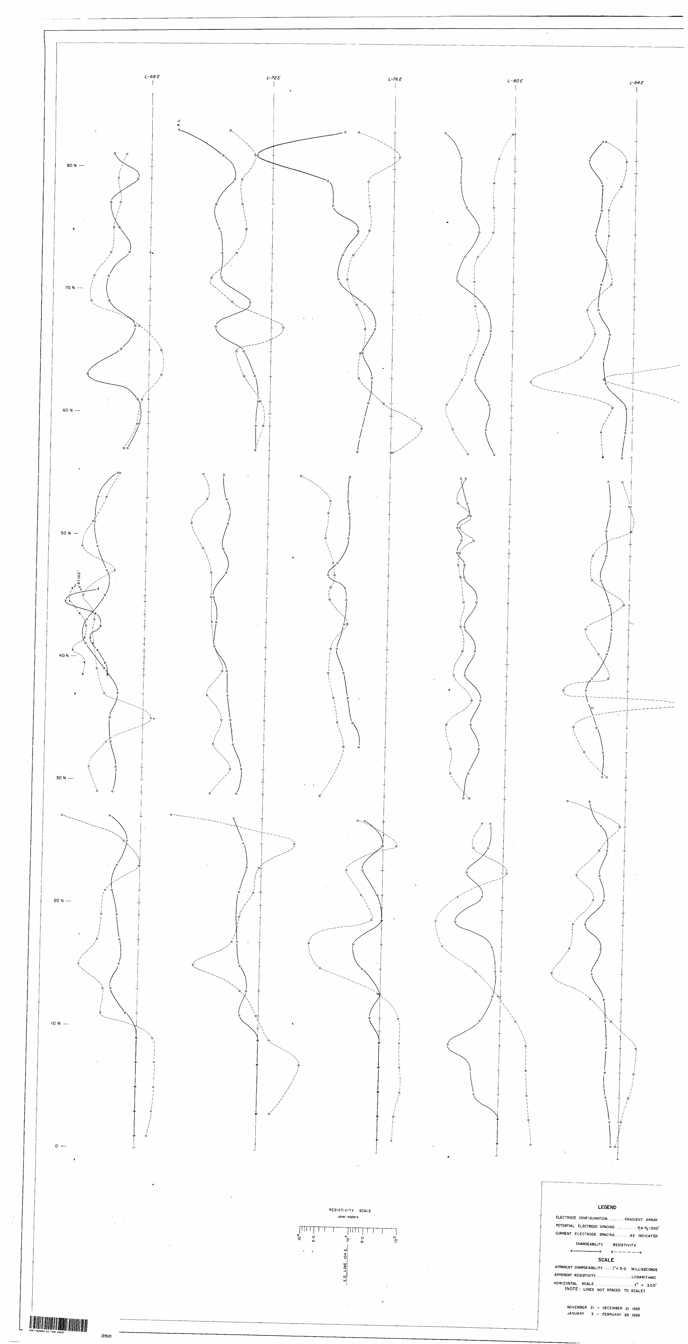
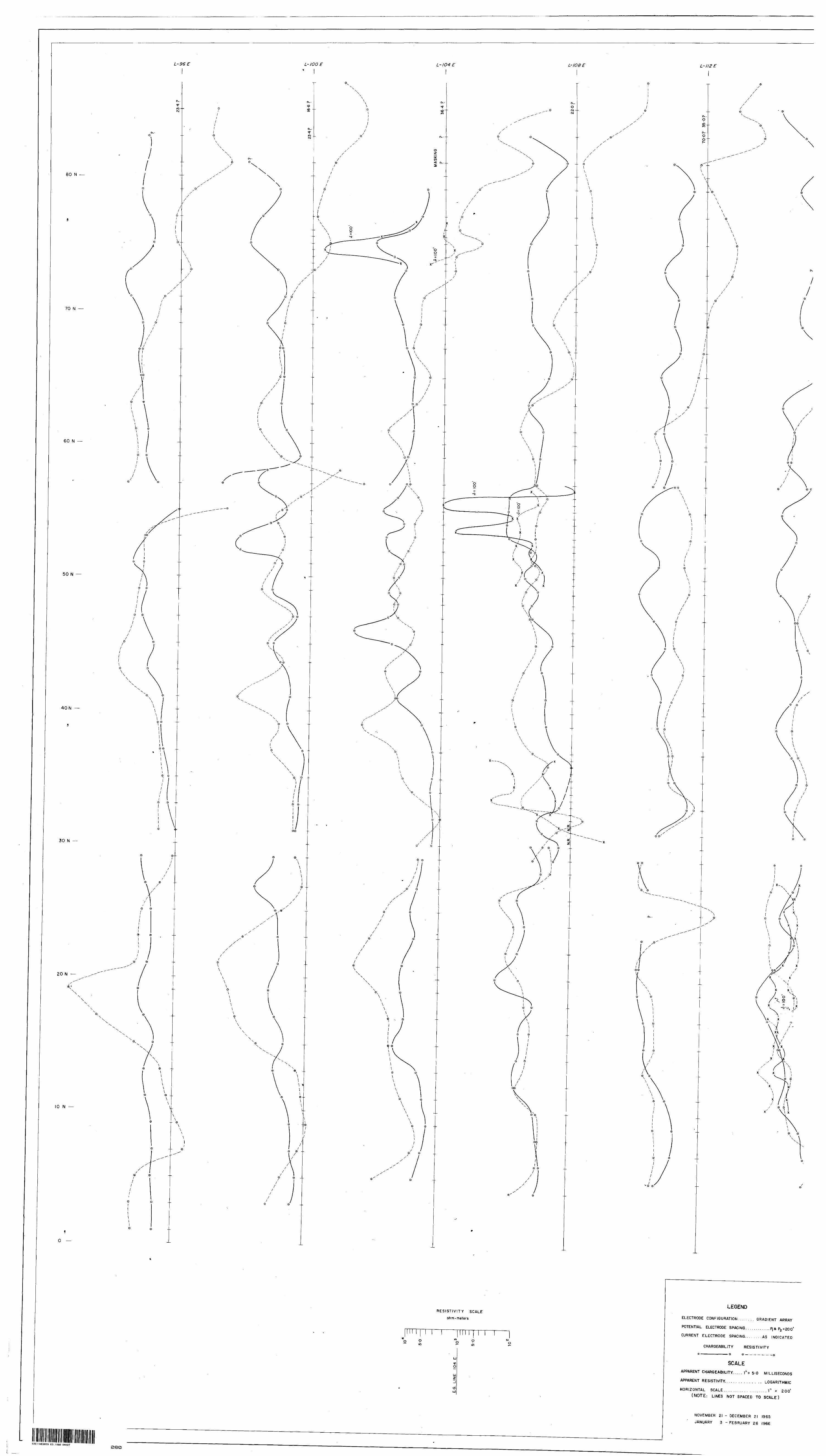
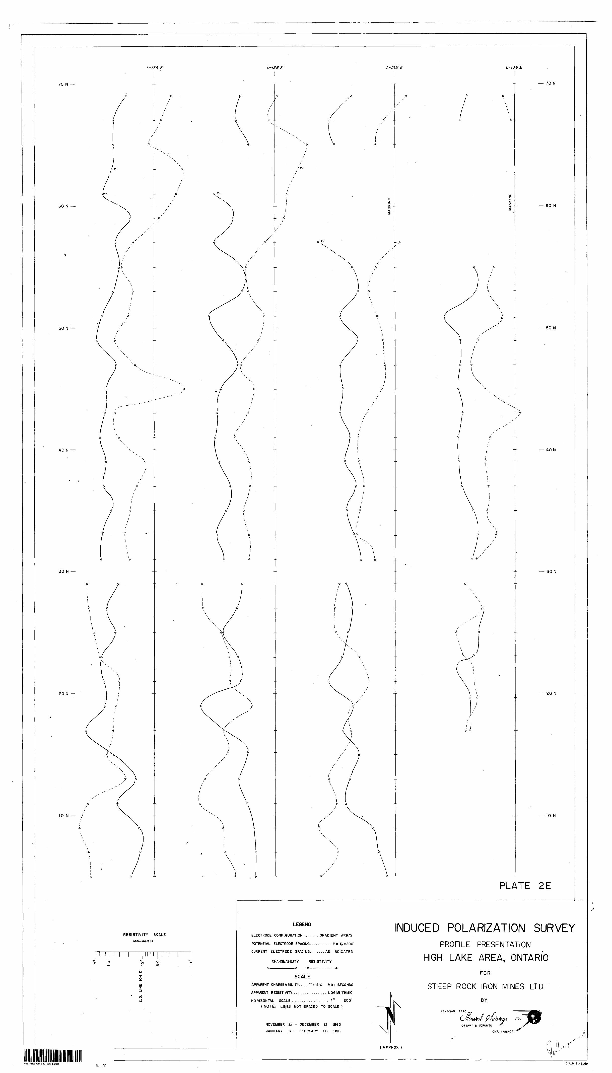
The results of the IP survey are plotted as combined
apparent chargesbility and apparent resistivity profiles at the
following scales; 1" » 5.0 milliseconds for chargeability,
resistivity in ohm meters on a logarithmic scale as shown on the
profile plates, 1" » 200 ft. horizontally. For the sake of clarity
of presentation, the profiles arc not spaced to scale. The
profiles are presented on plates 2A, B, C, D and E.
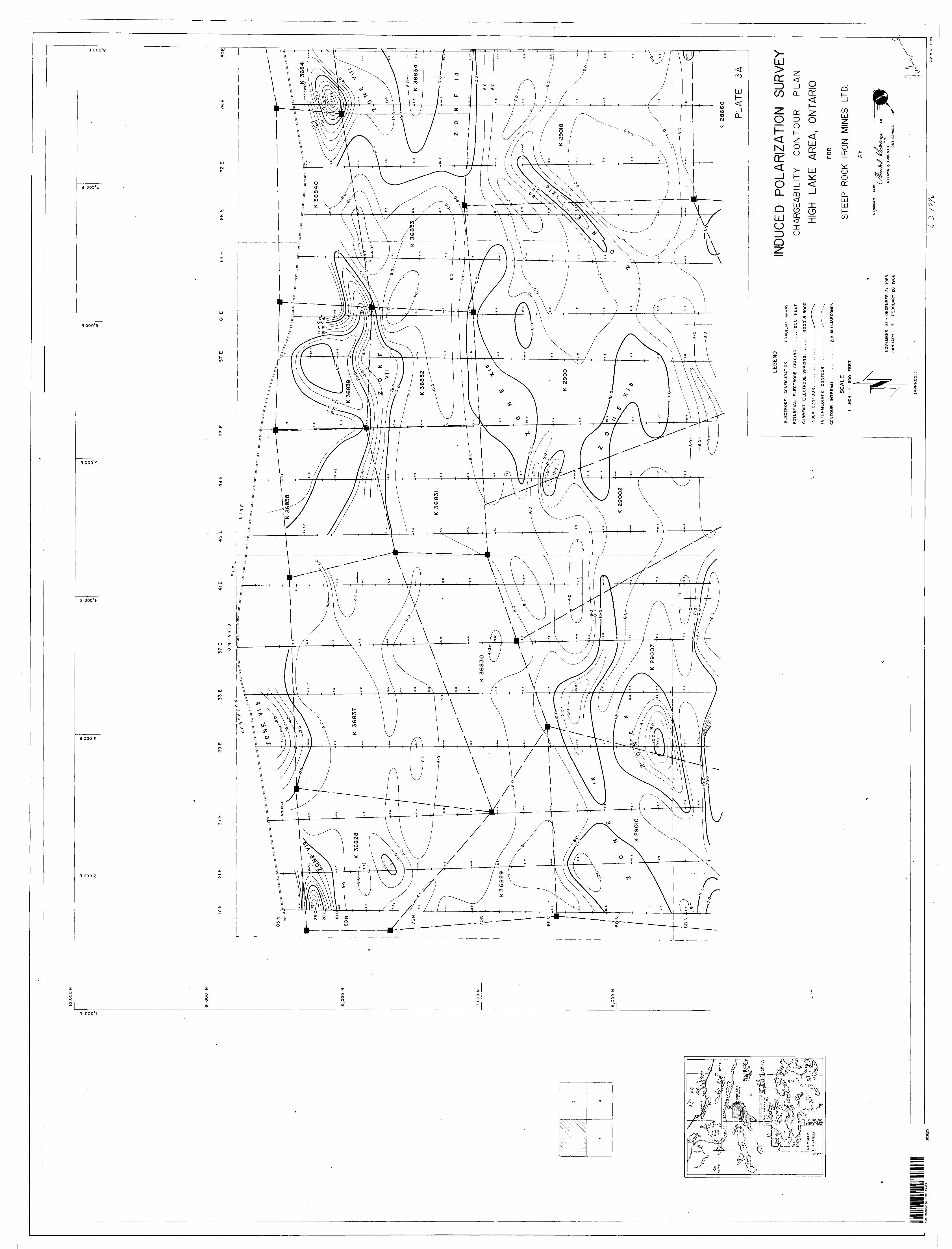
The apparent chargeability result* are also presented
on plates 3A, B, C and D in contoured form at the scale of
1" * 2CO ft. When the Gradient Array electrode configuration is
employed, the background chargeability response sometimes varies
considerably from survey block to survey block due to non-
homoganeous current distributions. The results therefore often
-auflt be contoured within the individual blocks. In this particular
case very few discrepancies exist between blocks and a relatively
uniform background was observed throughout the area.
To aid in the interpretation of the induced
polarization survey Steep Rock Iron Mines Ltd. supplied Canadian
Aero Mineral Surveys Limited with the results of a ground
magnetic survey of the area which was carried out in January 196f
by w. G. Wahl Ltd., willowdale, Ontario. Geological maps covering
moat of th<» survey area were also supplied.
A large number of anomalies were indicated and
outlined by the IP survey. These anomalies have been grouped into
16 eoncs with sorae tones subdivided into trends within the zones.
A high degree of masking made it impossible to obtain
chargeability readings over parts of the grid established on the
ice of High Lake as wo11 as over the lake at the east end of the
property. Masking effects also made observations impossible in
aome swampy areas throughout the grid.
In some areas readings were at times very difficult to
obtain because of high contact resistances on the potential
electrode's and at other tiraes because of extremely low primary
voltages. For example, high chergeabilities noted north and east
- 5 -
of Zone I are questionable because the primary voltage* were so
low in magnitude that they could not be measured accurately.
Questionable reading* are so marked on the chargeability contour
plans.
Zones I to XVI will be discussed in turn below.
Zone I (a, b, c, d), which is located in the northeastern
quarter of the survey area, appears to be fairly continuous from
line 721, (approximately 72 North) to line 112E (approximately 73 North)
with an offshoot (Ic) to the northeast. An apparent break in the
zone occurs on line 84E where lower apparent chargeabilitiec were
observed, probably due to some masking effect caused by the
presence of a swarap between 70 North and 75 North.
Approximately twice background apparent chargeability
responses wer« obtained in correlation with magnetics in the order
of 1000 - 5000 gammas. The peak I.P. responses are accompanied by
corresponding lower apparent resistivity values from line 92E to
1041. Maximum chargeahility responses of about 13.0 milliseconds
obtained in lone I(c) and J(b) indicate a concentration of
v-larlzai'lo roatorial {metallic sulphides) of 1% 3% average by
volume. 2% 6% disseminated magnetite could give the same
-:;3<jni*-:vice of response and in view of the magnetic correlation,
M^gnfctito is probably largely responsible for the higher than
nor-A 1 ch«r«aabili,tiesi hore. However, a thorough check of any outcrop
vl*" Ir, vonc I for tho presence of metallic sulphides is recommended,
If oncoufaainc; results are obtained from a geological and/or
- -
geochemical check, the zone should ba further evaluated by diamond
drilling. The tone has beet definition on line 104E where aone
detailed work employing a potential electrode spacing of 100 ft.
waa carried out. The detailing indicates the zone to have a near
surface expression on line 104E at 74 + 50 North. A diamond drill
hole to test this section of the lone should be collared at 74 North
on line 104E and drilled north along the line at an angle of 45* for
200 - 300 feet.
SOWS II
Zone II is located in the eastern portion of the survey
area near the centre of the grid. It extends fro* line 92E (51 North)
to line IKE (55 North). Between line 96E and line 104B this cone
is located on the eouth edge of a magnetic anomaly of 1000 - 2000
gammas.
One diamond drill hole (SA-24) has been completed near
the west end of the anomalous zone. However/ this hole was drilled
approximately along the strike of the sone and near the south edge
of the anomaly. Some pyrite and ohaloopyrite were apparently
intersected in this drill hole, establishing at least the presence
of metallic sulphides within the sone* Detailing on line 10&E
employing a potential electrode spacing of 100 feet indicates that
the sone here consists of two parallel bands of mineralisation with
near surface expressions at 53 + 50 North and 55 + 50 North.
D.D.H. SA-24 did not test either of these sones. A single well-
defined anomaly peak with relatively low apparent resistivity
correlation was obtained on line 100K.
To investigate further the source of the anomalous
KifM'! l*i this sons the following drill holes are suggested,
(i) collar at 52 + 5f> North on line 108K; drill
north along the line at an inclination of 45*
for approximately 200 feet.
(ii) collar at 54 + 50 North on line lOSEj drill
north along the line at an inclination of 45*
for approximately 200 feet.
(ill) collar at 51 North, on line 100E and drill north
along the line at an inclination of 45* for
200 - 300 feet.
If encouraging results are obtained in the above
drilling then Eone IT should also fo drilled on line 92E.
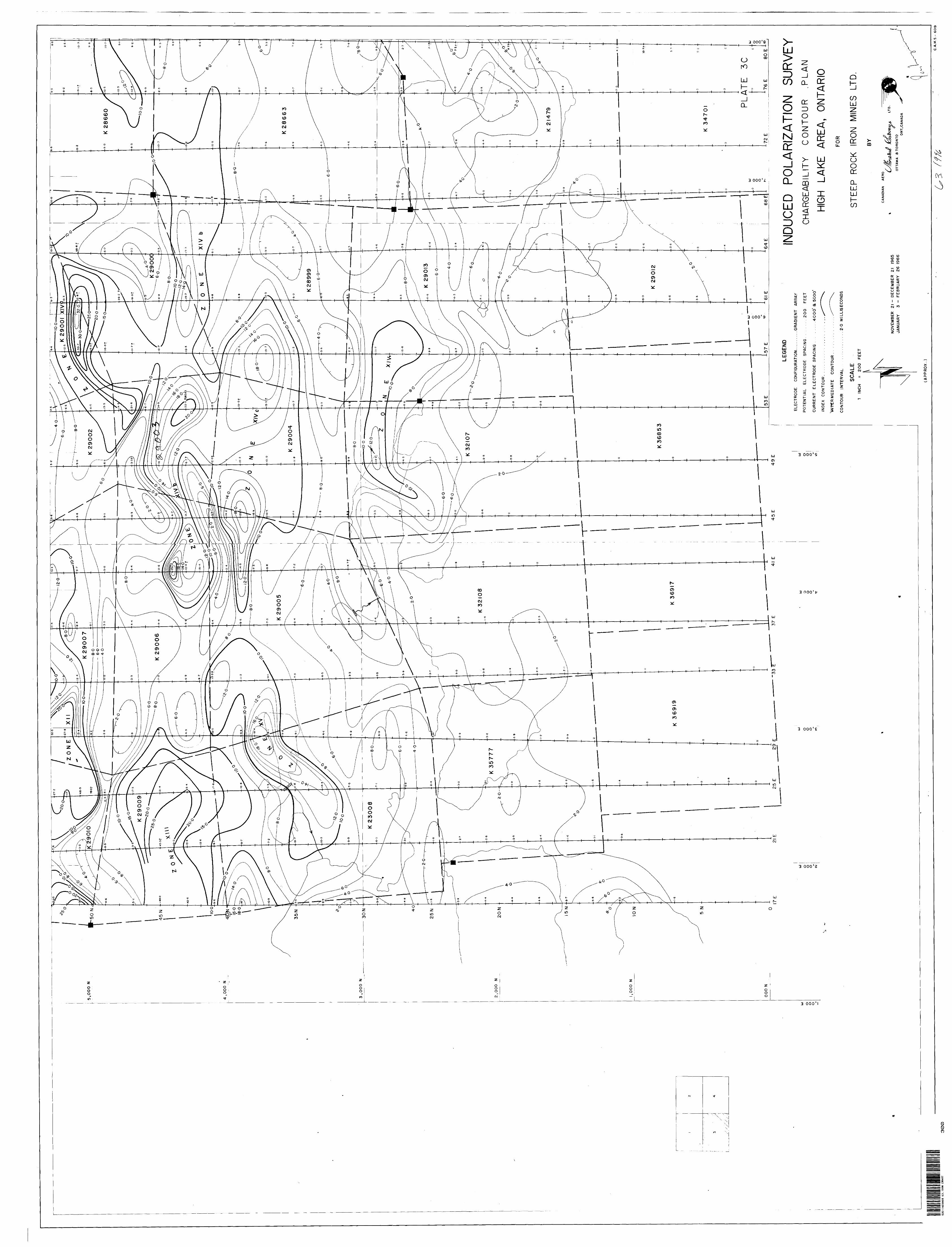
gone III is located in the east end of th« survey area.
It covers most of th« region described by the coordinates 30N to
52N, 12OK to 136i . 171(a) expends the «one west to line 108E just
south of th^ cast end of Zone II. Zone III which is outlined by
tho 10 millisecond contour line coincides almost exactly with the
distribution of baa it. volcanic rocke in thi« section of the
property, Apparent oh&rgeabilitie* within the zone of 10-12 milli
seconds probably reflect only the slight magnetite content of this
rock type. Scna IIT(b) has been well tested by diamond drill holes
E-42, i: 43 and 1-44,
- 8 -
ZONE IV
rone IV, located between 45N and 47N on line* 104E,
is an interesting anomaly although it is fairly limited in extent.
It appears to be situated on the contact between the basic
volcanico urn) tho quartz porphyry. Three diamond drill holes,
RA-6, BA-7 and SA-8, wore collared just outside the anomaly and
drilled etway from th«* zone. Apparently all these holes intersected
some mineralization. A maximum chargeability response of 16.7
milliseconds at 46H, 104E indicates polarizablo material of a
concentrati n of 2% - 4% average by volume. A resistivity "low"
was observed in correlation with the I.P. anomaly on line 104E,
Zone V is located in the southeast oorner of the survey
area and appears to be confined to a region in the quartz porphyry
mapped as basic volcanics. In general, good correlation exists
between the anomalous I.P. responses and a zone of higher magnetics
of 5000 - 10,000 gammas. Indications of copper, molybdenum and
magnetite have been noted on the ground and in drill holes within
2one V(a). Drill holes HL-1 and HL-2, as well as P-19 and F-20,
should indicate th« type of polarizable material causing the higher
than normal I.P. responses here. Two anomaly peaks of about 14.0
milliseconds within anomaly V{a) at 20 North on line 108E and at
19 Horth on line 136E have not been checked by drilling. These
responses suggest rcinexallration of 1.5% - 3,5% average by volume.
However, these pr»ak responses might b« partly due to magnetite.
In Zott* V(b) apparent chargeabiiities of 14.0 - 15.0
s-i were obtained at 17 North on line 124H, 19 North on
lino 1231:, end at 21 North on line 132K. Correlating low apparent
,v;sl r(-J v'tleK were o^v^rved on line 129H an<*. 132E, These peak
e produce an poarent northeast-southwest trend which cute
,: t>.<-- In i'u;ftted east-west trends suggested by the ground iiagnatics.
Drill holes SA-17, 18, 19 and 8A-20 were collared near
f.he. south-western edge of ?one V(b) anr! drilled towards the south away
froi.i tho regior, of |>eak responses. Apparently both chalcopyrite
and taolyb<!e;auf, ^.-rer^ intersoctea in thes«i holes. A diamond drill
Uole to tost the source of this zone should be collared at 20 North
on line 128E and drilled south along the line at an inclination of
45*. The petik reoponee of 15.4 milliseconds at 19 North on line
328I-: suggest;? a concentration of 2% - 4% avoxage by volume of
LJolarizable Material. As for fcoao V(a) the response might be caused
by a combination of metallic sulphides am! magnetite or possibly by
Magnetite alone.
r
2ones VI, VII and VIII are located in the north-western
uarter of tlit survey aree 40C-SOO feet south of the "Northern
Ontario ripe Line".
The pipe line appears to have some effect on the current
distribution in that aiyn reversals were noted on readings adjacent.
to the iirif- on sowc of the traverses (2Sf, 29E, 76E) . However, it
.In not possible to arrive at an explanation which will attribute
the anomrloutt responses of these zones to the pipe line as was
- 10 -
considered at the time of the survey. The line would produce an
anomaly in places where it is grounded, but such a response would
be located immediately over the pipe (e.g. line 72E). Thorough
checks of these zones at the position of the peak responses is
recommended. Further geological napping, prospecting, and perhaps
geochemistry might assist in determining the cause of this
"parallel to the pipeline" trend of anomalies.
2one VI(a) is open to the west as the peak response of
28.3 milliseconds was obtained at 83 North on line 17E, the most
westerly line on the property. The shape of the anomaly peak here
suggests a source near surface* 3% - 7% average by volume of
polaricable material would be required to give this Magnitude of
response. No geological information is available for the region of
the anomaly.
Zone VI(b) is at the north end of line 291 and does
not have sufficient coverage to the north to determine whether the
reading of 20.0 milliseconds at 85 North is the peak response or
not* Hence in this case the pipe line is a possible source.
zone VII is a very distinct anomaly traced from 81 North
on line 64E to 83 North on line 4SE. Although the sone is a very
distinct one the quality of some of the readings in this sone leaves
some doubt as to the accuracy of the apparent chargeabilities of
58.9 milliseconds at 81 North on line 49B and 27.7 milliseconds at
83 North on line 45E. The masking effect at the north end of both
lines 45E and 41E was so severe that it was impossible to determine
the west extension of Zone VII. Except for the doubtful observation
at 83 North on line 4SE, no readings could be obtained in this
region. The anomaly occurs in an area mapped as andesites and
- u -
basalts with on* oration of carbonaceous material at tha north and
of Una 53E which makes a graphitic sourea a possibility, Thara
appears to ba quite a bit of outcrop in tha araa covered by this
anomaly, so a caraful gaologioal ohaok slight give an indication as
to tha sourea of tha anomalous rasponsas hara. Considaring tha
quality of tha readings, tha bast saction to ohaok with drilling
if drilling is daoidad upon is on lina 578. At 63 North on this
lina a paak rasponsa of 42.2 milliseconds indieatas 4% - 101 average
by volume of polarisable material*
IONB VIII
This anomaly is located 200 - 300 feat south of tha pipe
line between line 72E and 84E. An apparent changeability value of
3S.9 milliseconds at 81 North on line 7CE indicates 2.5% - 41 average
by volume of polarixabla material. If the geological environment
is the same as for Zone VIZ a careful check for graphitic material
is recommended before any drilling of this anomaly peak is
undertaken.
10HE IX
Zone IX was traced from 57H - 6IN on line 171 to fin on
line 4IE. The tone is still open to the west. The anomaly
correlates in general with an area mapped as tuffs with many
indications of disseminated pyrite and ohalcopyrite along the lone.
Because of "masking* the west end of the tone is not well defined,
- 12 -
but reliable readings were obtained on lines 29X and 371 where
peak responses of about 12.0 Billiseconds indicate polar!cable
material of 1% - 3% average by volume at 63K and «1W respectively.
An observation of 15.0 milliseconds at 6319 on line 33E is a poor
reading and is not considered reliable. A drill hole to test the
source Material should be collared at el + 50 North on line 29B
and drilled north along the line for 200 - 300 feet.
1OME X
lone X is located just south of anomaly XX in a region
of basic volcanic rocks. The higher than normal polarisation
responses in this tone appear to be related to features mapped as
strong topographic draws*. This coupled with the correlating low
apparent resistivities suggests an association with shearing. A
careful check for the presence of carbonaceous material is
recommended.
The peak response of 22.6 milliseconds at 57H on line 29B
indicates 21 - 5.51 average by volume of polarisable material here.
ZONE XI (a, b, c)
These three anomalies are located from line 4tl to 721
between 56 North and 72 North. All have peak responses of about 12.0
milliseconds suggesting It - 3% average by volume of polarisable
material. Except for Vone XI(a), considerable outcrop is indicated
in the anomalous areas but no trace of metallic sulphides is noted.
The anomalies appear to be associated with the volcanic rock rather
- 13 -
than the quarts porphyry in this area. The laok of Magnetic
correlation f*lea out magnetite as a possible source in this case
except at 6IN on line 53B where a chargeability of 10.2 milliseconds
corresponds with a Magnetic response of about 5000 gammas.
Zone XX(a) has its source within highly sheared tuffs
napped in this region*
Zone XI(b), although it appear* to out across the
quarts porphyry, has volcanic rooks sapped where the anomalous
readings are observed.
Zone XI(c) has a peak value of 12.5 Milliseconds at
63 North on line 688 where outcropping volcanic* are Mapped.
ZONB XII
Zone XII extends fro* SI North on line 17B to 81 North
on line 4IE with a break in the trend of anomalous responses on
line 21E, Although the accuracy of so«e of the observations in this
sone is questionable because of the very low range of primary
voltages, there is no doubt about the fact that a considerable
percentage by volume (5% * 10%) of polarisable material is present.
The area of the anomaly is mapped as basio volcanios but as for
Zone XI there are no indications of metallic sulphide
mineralisation* The type of responses obtained suggest a very near
surface source and since there is quite a bit of outcrop indicated
here a careful ground check of line 2SE between 4i North and
54 North and of line 29E between SO North and 54 North should give
some indication as to the source material.
- 14 -
A diamond drill hole to tact thia feature should be
collarad at 51 « SO North on Una 2fE and drilled north along the
lina at an inclination of 4S* for a distance of 200 * 300 feet.
80NE
Bone XIZI ia located about SOO feet south of Bone XII.
Hera apparent ohargaabilities in the order of 40.0 - SO.O Billisecond*
were observed indicating polaritabla Material of a concentration of
4.51 - 12% average by volume. However, aa in Sone XII, the accuracy
of some observations is questionable because of the vary low range
of primary voltages. The anomaly ia open to the wast. On lina 17E
the abrupt change from 42*6 milliseconds at 4 3 North to -48.0
milliseconds at 45 North is an example of a phenomenon sometimes
observed when dealing with a source that comes close to surfaoa and
has a flat dip. In thia case the near surfaoa expression of the
causative body (with a flat dip towards the south) should be in the
region 43 North to 44 North on lina 17E, At approximately 44 North on
line 25E a shear with pyrite and pyrrhotita has bean mapped
indicating that this type of mineralisation is perhaps responsible
for the anomaly. A careful geological and geochemioal check is
recommended in this tone before drilling is undertaken.
If drilling ia decided upon it is recommended that the
sona be tested on line 25E where the bast quality readings ware
obtained. A peak response hare of 2S.4 milliseconds indicates
2.5% - C% average by volume of polar i table material. The drill hole
should be collared at 41 « 50 North on line 25E and drilled north
along the line at an inclination of 45* for at least 300 feet.

- IS -
It might b« netad that drill holes SB-4, !*$ and
SB-6 on or near the aouth flank of anomaly XIII intereectad acme
metallic aulphidaa. Apparent ehargeabilitiea in the region of
thaaa holes are in the ordar of 10 milliseconds indicating 1% - 21
average by volume of polar!table material.
EOEE XIV {a, bf c)
lona XIV ia by far the moat extensive anomalous araa
outlined by the I.P. survey. It cover* nearly all of the araa
between linaa 4IB and 72X from 14 North to S3 Morth. Three separate
trend* XIV (a, b, e) appear to exist within thia none.
As for aoaui of the other sonaa in thia part of the
survey araa, the accuracy of aoma of the readings ia questionable
because of the vary low primary voltages observed. However, enough
reliable observations were obtained to establiah without any doubt
the praaanoa of considerable polarisable aatarial in the region of
thia gone.
lone XIV ia located within an araa Mapped as quarts
porphyry. The presence of pyrita haa baan established at about
38 North, 43 East* 41 Morth, 3 Bast and at about 35 north, 51 Baat
where chalcopyrite and magnetite vare alae noted*
Eona XIV(a) haa a p*»k response of approximately 30.0
milliseconds at 51 North on lines 571 and «1E naar a geological
contact between the quart! porphyry and granodiorita. Vary low
primary voltages (.001 * .005 volts) ware observed within thia tone
naking reading very difficult to obtain with accuracy. 3% * 71
average by volume of polaritable material ia indicated by the peak
- 16 -
responses on lines 57E and 6IE. The shape of the anomaly peaks
here suggests a source coming close to surface at 51 North and
dipping towards the south. Because of the better quality of readings
that was obtained on line 57E, drilling of this tone is recommended
on this traverse. The hole should be collared on line 57E at
49 + 50 North and drilled toward the north along the line at an
inclination of 4 5* for 200 - 300 feot.
Zone XIV(b) is a 3600 foot long east-west anomaly
extending from approximately 43 North on line 418 to 41 North on
line 76E, Peak values considered reliable were obtained, on line 4IE
at 44N (22.2 milliseconds) on line 45E at 43N (11.7 milliseconds)
on line 6IE at 43N (15.7 milliseconds) and on line 64E at 43 North
(13.3 milliseconds). Detailed work employing a potential electrode
spacing of 100 feet conducted on line 68E over tone XXV(b) indicated
a near surface source at 44 * 50 North where a peak chargeability
of 16.3 milliseconds was obtained.
Zf drilling of this tone is undertaken it should be
carried out on one of the above traverses, Questionable peak values
were obtained on lines 49E and 53E because of very low primary
voltages and high potential electrode contact resistances*
Good quality readings were obtained la Bone XIV(c) except
on line 53E. Peak responses of approximately 20.0 milliseconds
were observed on line 458 at 39 North and on line 57K at 37 North.
Magnetite might be at least partially responsible for the anomalous
responses obtained at the west end of anomaly XIV(c) (lines 41E and
45E). However, the peak on line 57E lacks magnetic association*
- 17 -
Apparently some copper mineralisation was noted about 500 feet west
and slightly south of thia anomaly peak.
A drill hole to teat the source material here (2% * SI)
should be collared at 36 4 50 North on line S7S and drilled south
along tht line at 45* for 200 - 300 feet.
ZONE XV
Good quality readings were obtained over thia sone of
polarisable material. The sone extends from about line 21E at
34 North to line 33B at 41 North. The maximum response was noted
on line 29E where chargeabilities of 18 * If milliseconds were
obtained at 37 North and 38 North. This peak appears to fall on
the contact between the basic volcanic* and quarts porphyry*
Magnetic correlation of 1000 - 2000 gammas existsat this point
so some magnetite might contribute to the anomalous response here.
A drill hole to check this occurrence should be collared at
36 + 50 North on line 29E and drilled towards the north at an
inclination of 45* for a distance of 200 - 300 feet.
EONS XVI
This narrow sone extends from about line 49B at 29 North
to about line 57E at 29 North. Peak responses are about 12.0
milliseconds indicating 1.5% - 3% average by volume of polaricable
material. Drill hole SB-1 appears to out this sone fairly well and
the pyrite and chalcopyrite intersected is probably the source of
the I.P. responses here.
in. CONCLUSIONS AND RECOMMENDATIONS
Because of the largo nunber of chargeability anomalies
obtained of which vary few can b« explained or partially explained
at this tine, further work in the fora of detailed geological
mapping and perhaps geochemistry is recommended as the next step in
evaluating the anomalous ronee. Where significant anomalous
responses were obtained and the nature of the polari*able material is
not known, a drill hole location has been given in the event that
drilling might be undertaken pending further evaluation by geology
and/or geochemistry.
Respectfully submitted
_W.Peer Norgaard, p. Eng. Geophysicist
OTTAWA, Ontario 16 May 1966
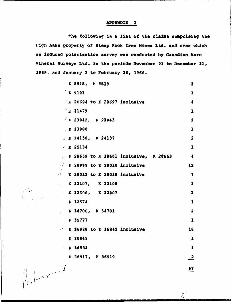
APPENDIX I
The following in a liat of the claims comprising the
High Lak« property of Steep Rook Iron Mines Ltd. and over which
an induced polarisation survey was conducted by Canadian Aero
Mineral Surveys Ltd. in the periods November 21 to December 21,
1965, and January 3 to February 26, 1966.
K 3318, K 8519 2
' K 9191 1
K 20694 to K 2069? inclusive 4
"K 21479 1
- K 23942, K 23943 2
, K 23980 1
J K 24136, K 24137 2
v K 25134 1
, K 28659 to K 28661 inclusive, K 28663 4
7 X 28999 to K 29010 inclusive 12
K 29012 to K 29018 inclusive 7
K 32107, K 32108 2
K 32306, K 32307 2
K 32574 1
K 34700, K 34701 2
K 35777 1
K 36628 to K 36845 inclusive 18
K 36848 1
K 36853 1
K 36917, K 36919 _2
67,-v- Y,',-,-
I
File: 63.1996
THE MINING ACT
Assessment Work Credits
Name: STEEROLA EXPLORATIONS LIMITED c-Utms
Township or Area: EWART TWP.
Number of Assessment work days per claim:
Geophysical 38.8 Induced Polarization
Mining Claims: K 20694 to K 20697 inclusive
K 21479
K 23942 & 23943
K 23980
K 24136 & 24137
K 25134
K 28659 to 28661 Inclusive
K 28663
K 28999 to 29010 inclusive
K 29012 to 29018 inclusive
K 32107 & 32108
Geological nil
K 32306 & 32307
K 32574
K 34700 & 34701
K 35777
K 36828 to 36845 inclusive
K 36848
K 36853
K 36917
K 36919
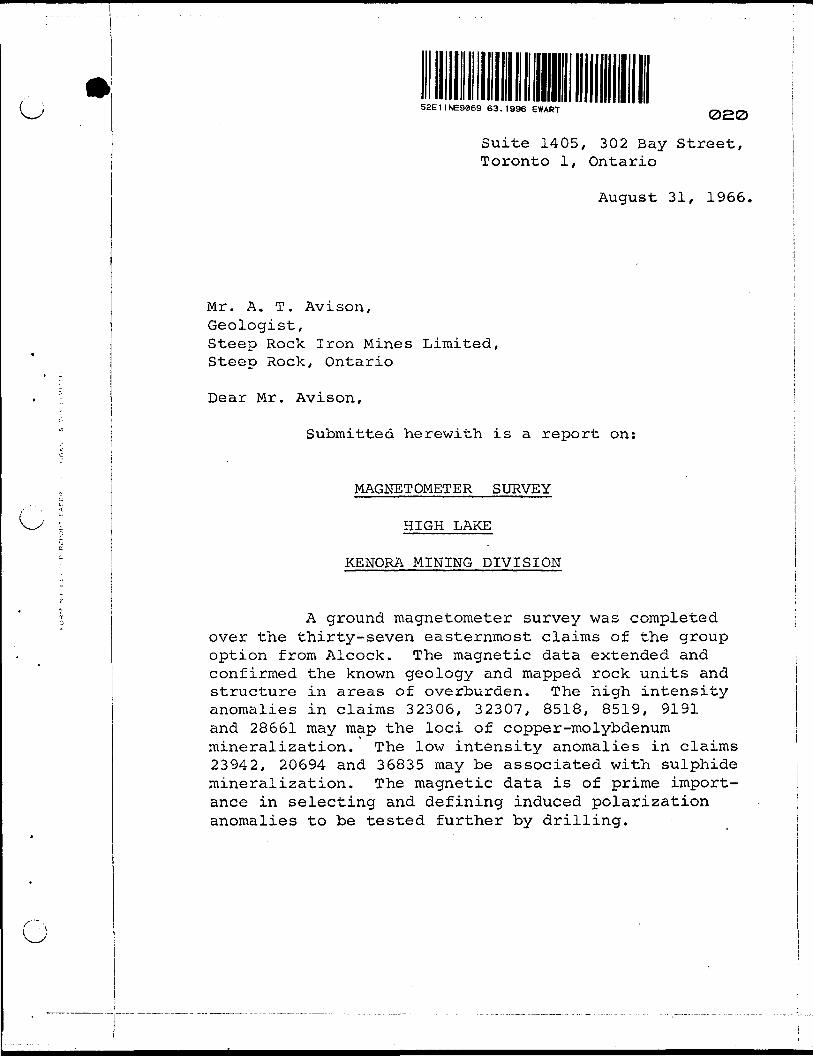
o S2E11NE9869 63.1996 EWART oaoSuite 1405, 302 Bay Street, Toronto 1, Ontario
August 31, 1966.
Mr. A. T. Avison,Geologist,Steep Rock Iron Mines Limited,Steep Rock, Ontario
Dear Mr. Avison,
Submitted herewith is a report on:
MAGNETOMETER SURVEY
HIGH LAKE
KENORA MINING DIVISION
A ground magnetometer survey was completed over the thirty-seven easternmost claims of the group option from Alcock. The magnetic data extended and confirmed the known geology and mapped rock units and structure in areas of overburden. The high intensity anomalies in claims 32306, 32307, 8518, 8519, 9191 and 28661 may map the loci of copper-molybdenum mineralization. The low intensity anomalies in claims 23942, 20694 and 36835 may be associated with sulphide mineralization. The magnetic data is of prime import ance in selecting and defining induced polarization anomalies to be tested further by drilling.
2.
O
ol
O
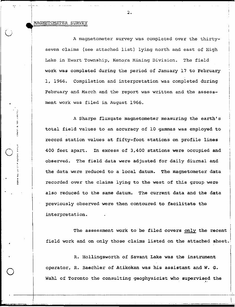
MAGNETOMETER SURVEY
A magnetometer survey was completed over the thirty-
seven claims (see attached list) lying north and east of High
Lake in Ewart Township, Kenora Mining Division. The field
work was completed during the period of January 17 to February
1, 1966. Compilation and interpretation was completed during
February and March and the report was written and the assess
ment work was filed in August 1966.
A Sharpe fluxgate magnetometer measuring the earth's
total field values to an accuracy of 10 gammas was employed to
record station values at fifty-foot stations on profile lines
400 feet apart. In excess of 3,400 stations were occupied and
observed. The field data were adjusted for daily diurnal and
the data were reduced to a local datum. The magnetometer data
recorded over the claims lying to the west of this group were
also reduced to the same datum. The current data and the data
previously observed were then contoured to facilitate the
interpretation.
The assessment work to be filed covers only the recent
field work and on only those claims listed on the attached sheet.
R. Hollingsworth of Savant Lake was the instrument
operator, R. Baechler of Atikokan was his assistant and W. G.
Wahl of Toronto the consulting geophysicist who supervised the
O
O
O
3.
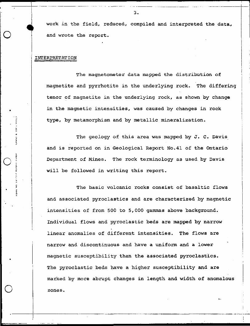
work in the field, reduced, compiled and interpreted the data,
and wrote the report.
INTERPRETATION
The magnetometer data mapped the distribution of
magnetite and pyrrhotite in the underlying rock. The differing
tenor of magnetite in the underlying rock, as shown by change
in the magnetic intensities, was caused by changes in rock
type, by metamorphism and by metallic mineralization.
The geology of this area was mapped by J. C. Davis
and is reported on in Geological Report No.41 of the Ontario
Department of Mines. The rock terminology as used by Davis
will be followed in writing this report.
The basic volcanic rocks consist of basaltic flows
and associated pyroclastics and are characterized by magnetic
intensities of from 500 to 5,000 gammas above background.
Individual flows and pyroclastic beds are mapped by narrow
linear anomalies of different intensities. The flows are
narrow and discontinuous and have a uniform and a lower
magnetic susceptibility than the associated pyroclastics.
The pyroclastic beds have a higher susceptibility and are
marked by more abrupt changes in length and width of anomalous
zones.
O
(J
O
4.
The acid volcanic rocks exposed in the northern
part of the claim group are marked by low, uniform changes
in magnetic susceptibility and are mapped by an intensity
range of from zero to 600 gammas. These rocks are predomin
antly rhuolite and dacite pyroclastics and are outlined by
linear anomalies.
It is most difficult to distinguish the metasediment-
ary rocks of the Keewatin group from the Crowduck Lake group
on the basis of their magnetic characteristics. The metasedi-
mentary rocks are mapped by narrow discontinuous linear
anomalous zones with magnetic intensity from zero to 5,000
gammas.
The porphyritic granodiorite is mapped by its low,
uniform magnetic susceptibility. The magnetic intensities
range from near zero to 500 gammas.
Superimposed on the general magnetic characteristics
described above are the increases and decreases in the tenor
of magnetite caused by regional and thermal metamorphism and
by the addition of magnetite contemporaneous with mineral
ization. Remnants of volcanic rocks within the granodiorite
are marked by a slight increase in the magnetic intensities
of the granodiorite. Unassimilated volcanic rocks in contact
with the granodiorite have a higher intensity caused through
the formation of magnetite during thermal metamorphism.**
O
o
5.
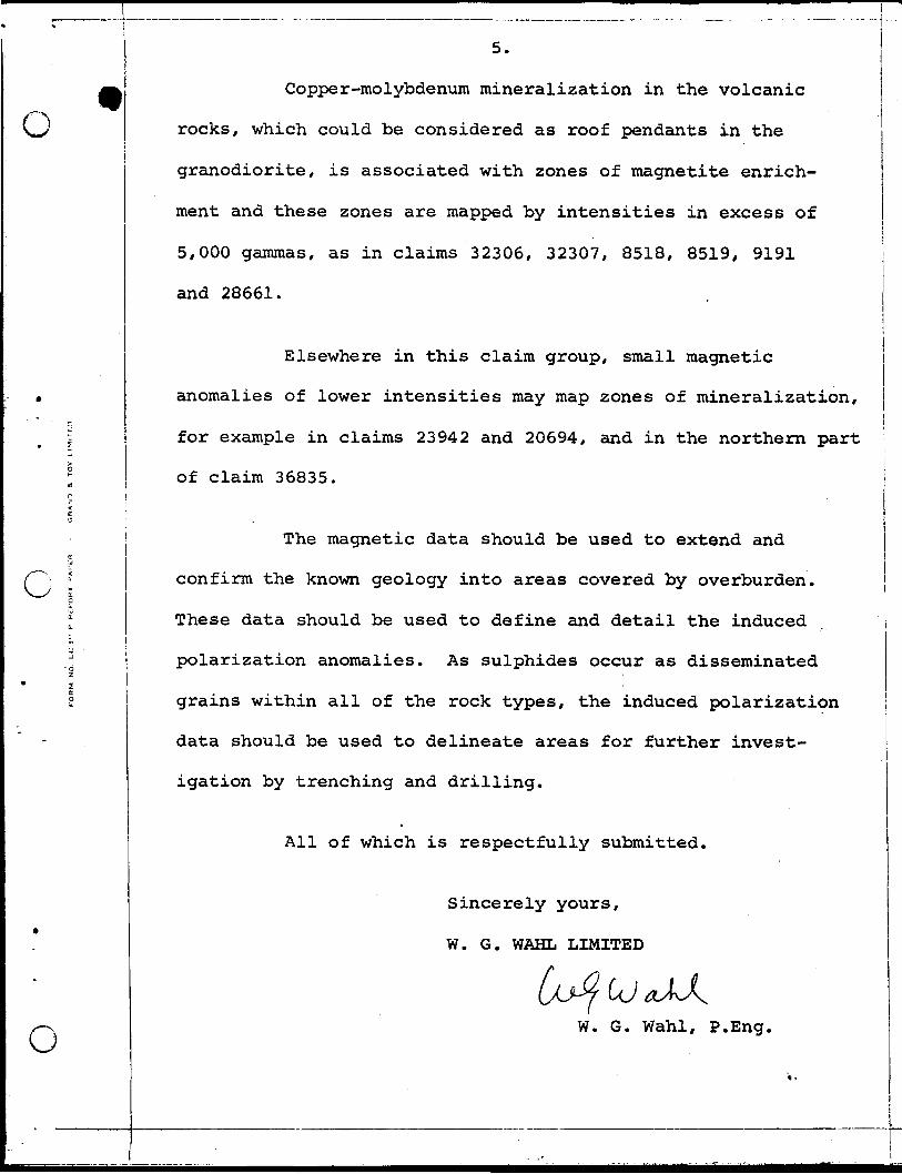
Copper-molybdenum mineralization in the volcanic
rocks, which could be considered as roof pendants in the
granodiorite, is associated with zones of magnetite enrich
ment and these zones are mapped by intensities in excess of
5,000 gammas, as in claims 32306, 32307, 8518, 8519, 9191
and 28661.
Elsewhere in this claim group, small magnetic
anomalies of lower intensities may map zones of mineralization,
for example in claims 23942 and 20694, and in the northern part
of claim 36835.
The magnetic data should be used to extend and
confirm the known geology into areas covered by overburden.
These data should be used to define and detail the induced
polarization anomalies. As sulphides occur as disseminated
grains within all of the rock types, the induced polarization
data should be used to delineate areas for further invest
igation by trenching and drilling.
All of which is respectfully submitted.
Sincerely yours,
W. G. WAHL LIMITED
o W. G. Wahl, P.Eng.
File: 63.1996
THE MINING ACT
Assessment Work Credits
Name: ______STEEROLA EXPLORATIONS LIMITED (cU>«s kJ<J
Township or Area: EWART TWP.
Number of Assessment work days per claim:
Geophysical 10 Magnetometer
Mining Claims: K 20694 to 20697 incl.
K 21479
K 23942 & 23943
K 23980
K 24136 & 24137
K 25134
K 28659 to28661 incl.
K 28663
K 29014 to 29018 incl.
K 32306 & 32307
K 32574
Geological nil
K 34700 & 34701
K 36834 to 36836 inclusive
K 36841 to 36845 inclusive
K 36848
52EI1NE9069 63.1996 EWART 030
HIGH LAKE OPTION
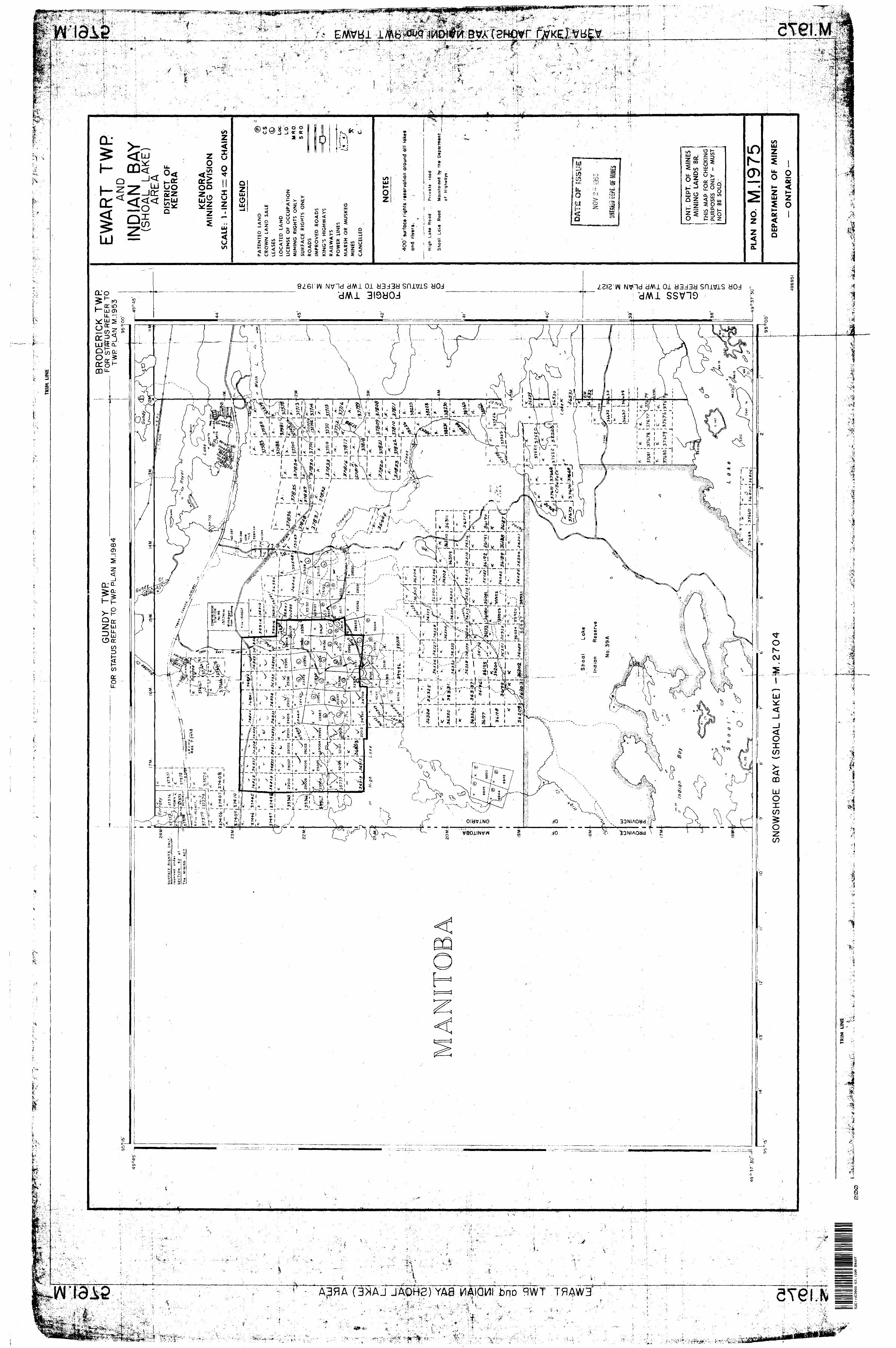
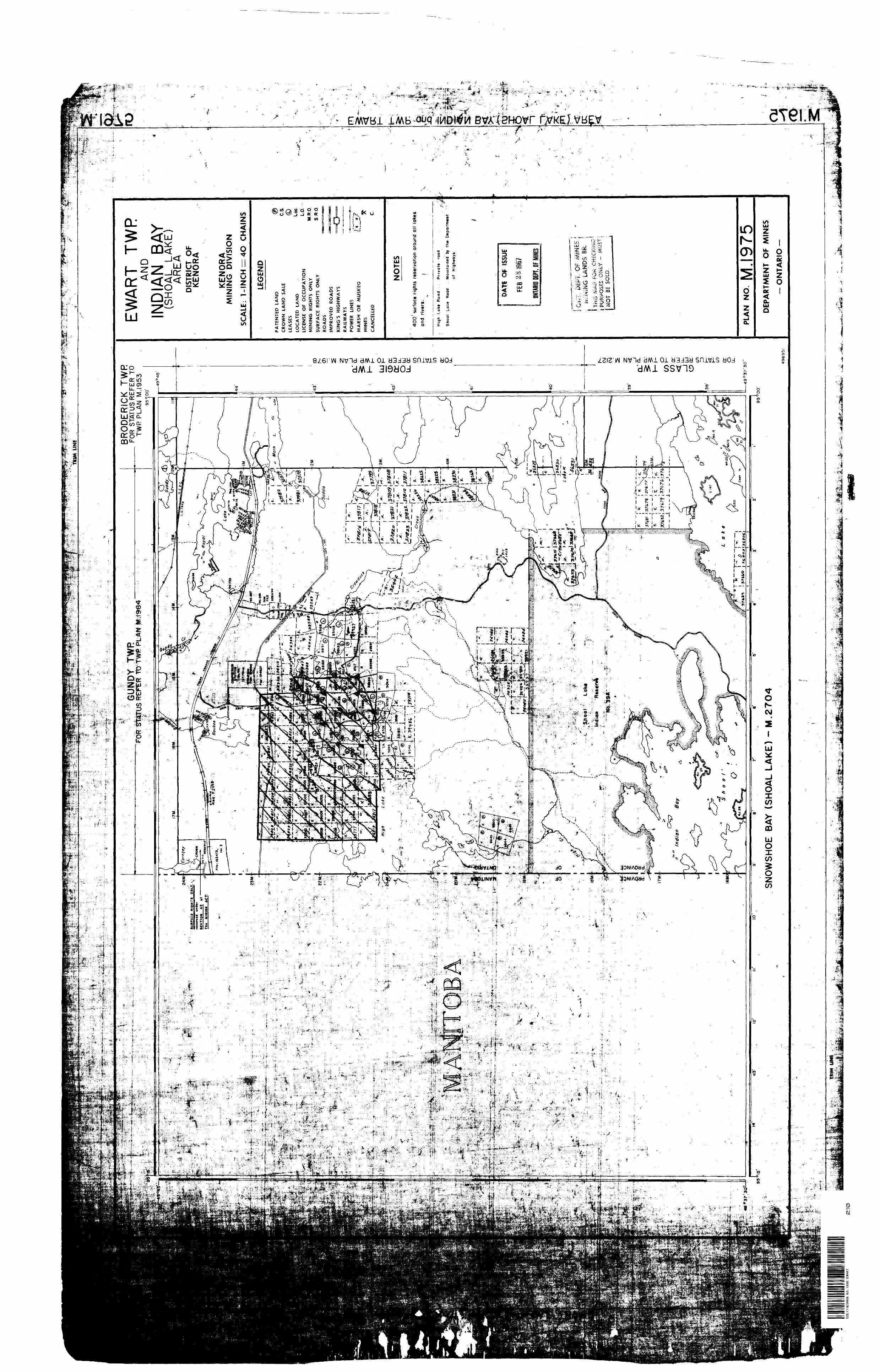
EWART TOWNSHIP
KENORA MINING DIVISION
PURPOSE OF REPORT
This report is written as a supplement to the reports of the
geophysical contractors covering surveys carried out during the winter of
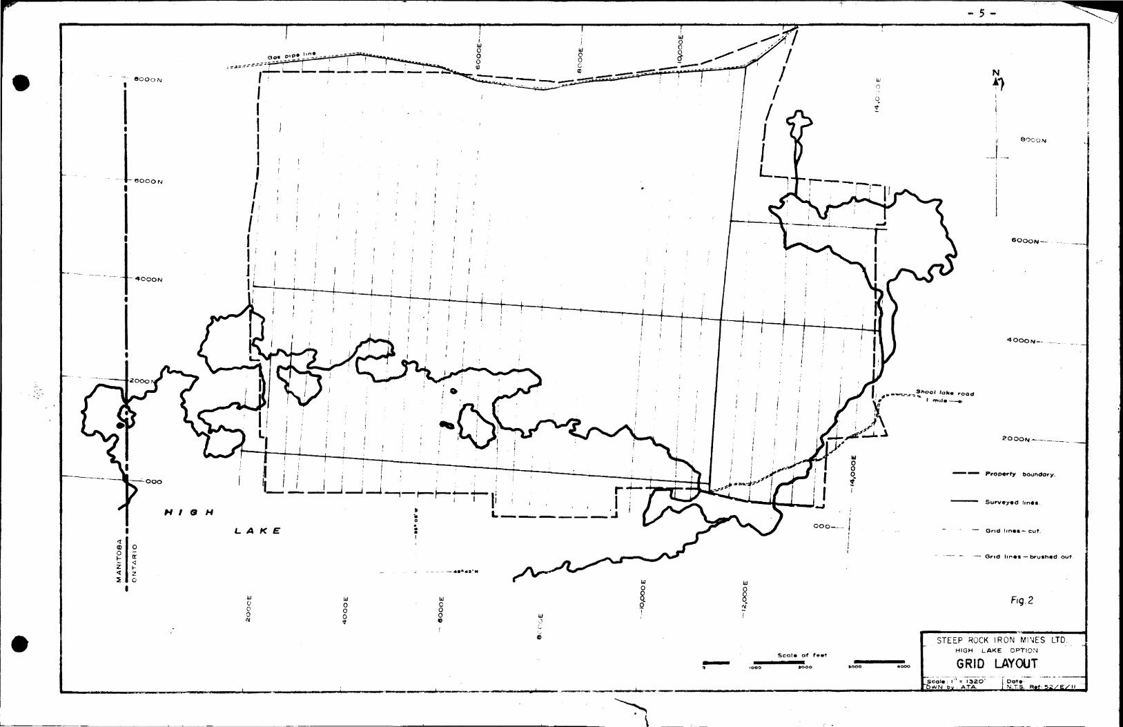
1965 - 66 on the claim group. The field work involved in the establishment
of the grid, linecutting and chaining is described. Previous work in the
area and a brief description of the geology and mineralitation as presently
known is given.
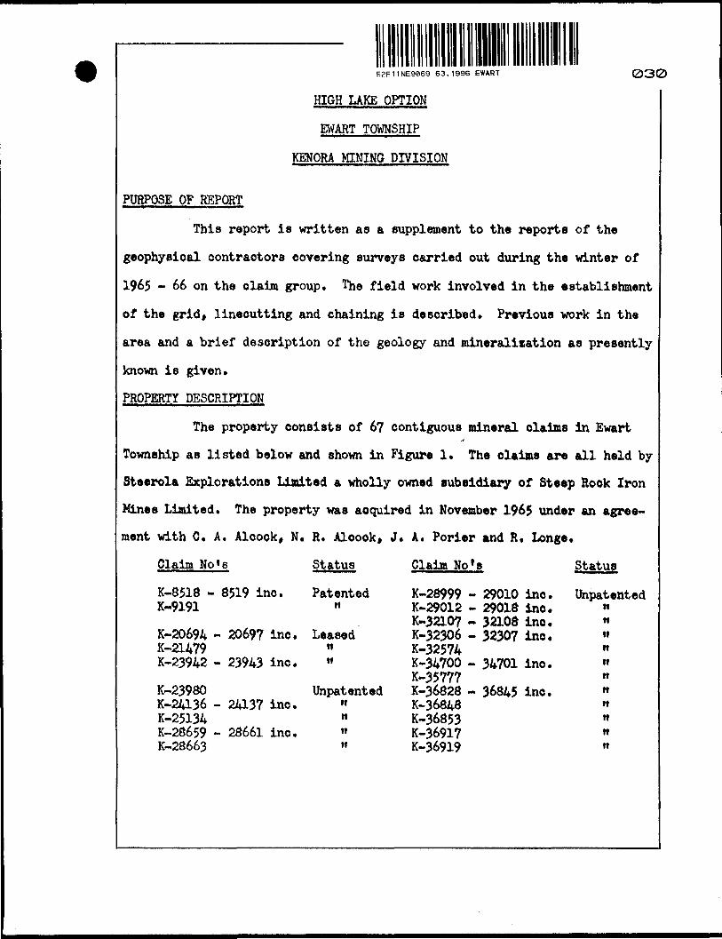
PROPERTY DESCRIPTION
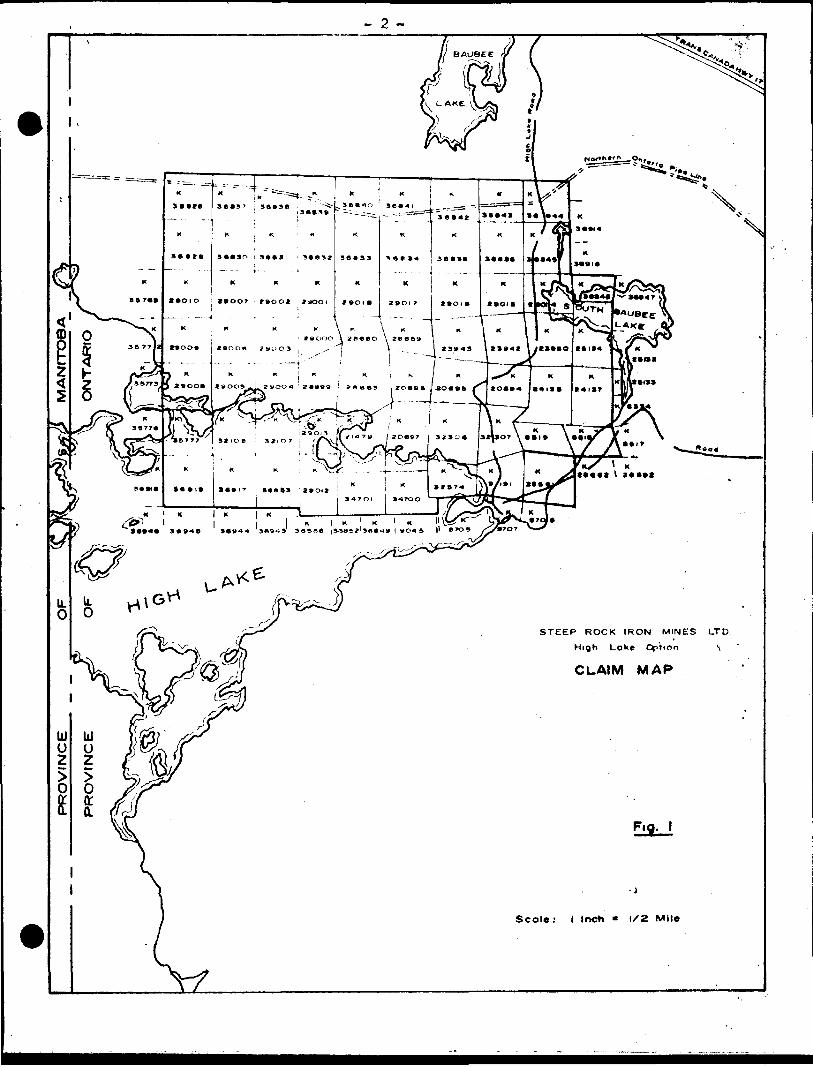
The property consists of 6? contiguous mineral claims in EwartI*
Township as listed below and shown in Figure 1. The claims are all held by
Steerola Explorations Limited a wholly owned subsidiary of Steep Rook Iron
Mines Limited. The property was acquired in November 1965 under an agree
ment with 0. A. Alcook, N. R. Aloook, J. A. Porier and R. Longe.
Claim No's Status
K-8518 - 8519 inc. PatentedK-9191 "
K-20694 - 20697 inc. LeasedK-2U79 "K-23942 - 23943 inc. »
K-23980 UnpatentedK-24136 - 24137 inc. "K-25134 nK-28659 - 28661 inc. "K-28663 »
Claim No*s
K-28999 - 29010 inc.K-29012 - 29018 inc.K-3210? - 32108 inc.K-32306 - 32307 inc.K-32574K-34700 - 34701 inc.K-35777K-36828 - 36845 inc.K-36848K-36853K-36917K-36919
Statut
Unpatented wtt ti tt tt tt tt tt tt n tt
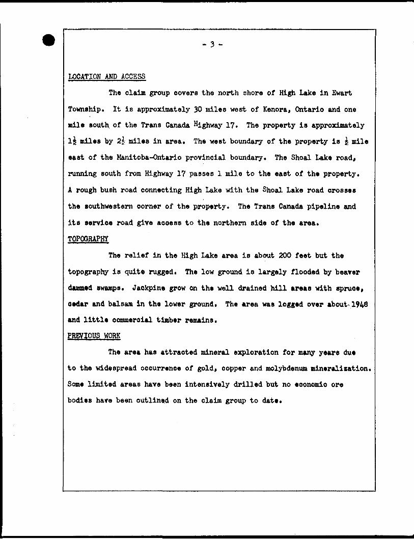
LOCATION AND ACCESS
The claim group covers the north shore of High Lake in Ewart
Township. It is approximately 30 miles west of Kenora, Ontario and one
mile south of the Trans Canada Highway 17 The property is approximately
l£ miles by 2^ miles in area* The west boundary of the property is | mile
east of the Manitoba-Ontario provincial boundary. The Shoal Lake road,
running south from Highway 17 passes 1 mile to the east of the property*
A rough bush road connecting High Lake with the Shoal Lake road crosses
the southwestern corner of the property. The Trans Canada pipeline and
its service road give access to the northern side of the area*
TOPOGRAPHY
The relief in the High Lake area is about 200 feet but the
topography is quite rugged. The low ground is largely flooded by beaver
dammed swamps. Jackpine grow on the well drained hill areas with spruce,
cedar and balsam in the lower ground. The area was logged over about*1948
and little commercial timber remains.
PREVIOUS WORK
The area has attracted mineral exploration for many years due
to the widespread occurrence of gold, copper and molybdenum mineralization.
Some limited areas have been intensively drilled but no economic ore
bodies hare been outlined on the claim group to date.
- 4 -
The geology of the area is covered in the Ontario Department of
Mines Geological Report No. 41 by J. C. Davies, 1965, with excellent maps
at 1" to i mile. The history of the exploration of the area is given in
detail. Records of much of this work are available in the Ontario
Department of Mines resident geologist's files in Kenora. The most recent
mineral exploration in the area was done by Selco Exploration in 1961 in
the western part of the claim group. They mapped the claims they held at
1M to 200* and did a magnetometer survey.
LINECUTTING AND CHAININQ
The grid cut by Selco Explorations in 1961 in the western part
of the area was brushed out, rechained and extended to cover the entire
claim group. The baseline of the grid runs east-west magnetic* North-
south lines perpendicular to the baseline were cut at 400 foot intervals
along the baseline with chainage pickets every 100 feet. These lines were
cut to the pipeline road in the north and the shore of High Lake or the
property boundary in the south. After freeze-up the lines were extended
to the property boundaries on the ice of High Lake and Eleotrum Lake* The
baseline and one north-south line (116E) were surveyed by transit. Tie
lines were surveyed on the ice of High Lake and along the pipeline road so
that all the north-south lines are tied in by transit survey at three
points*
- 6 -
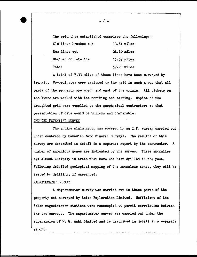
The grid thus established comprises the followings-
Old lines brushed out 13»6l miles
New lines out 28.10 miles
Chained on lake ice 15*57 miles
Total 57.28 miles
A total of 7«33 miles of these lines have been surveyed by
transit. Co-ordinates were assigned to the grid in such a way that all
parts of the property are north and east of the origin. All pickets on1
the lines are marked with the northing and easting. Copies of the
draughted grid were supplied to the geophysical contractors so that
presentation of data would be uniform and comparable.
INDUCED POTENTIAL SURVEY
The entire claim group was covered by an I.P, survey carried out
under contract by Canadian Aero Mineral Surveys, The results of this
survey are described in detail in a separate report by the contractor. A
number of anomalous cones are indicated by the survey* These anomalies
are almost entirely in areas that have not been drilled in the past.
Following detailed geological mapping of the anomalous zones, they will be
tested by drilling, if warranted.
MAGNETOMETER SURVEY
A magnetometer survey was carried out in those parts of the
property not surveyed by Selco Exploration Limited. Sufficient of the
Selco magnetometer stations were reoccupied to permit correlation between
the two surveys. The magnetometer survey was carried out under the
supervision of W. G. Wahl Limited and is described in detail in a separate
report.
- 7 -
PEOLOQYThe most detailed geological map and report of the area is the
Ontario Department of Mines map by J. C. Davies. This report shows more
rock types than were recognised by any of the companies that have explored
the area in the past. There is some difficulty in correlating the
geological data from previous work due to differences in the rock nomen
clature and to the different grids that have been used*
The property is underlain by a group of intermediate volcanic
rooks containing lenses of acidic volcanics and sedimentary horicons.
These rocks have been intruded by an acidic pluton which varies from
quart* feldspar porphyry through granodiorite to quart* diorite. The acid
intrusives are probably differentiates of one magma and contain local,
partially digested, remnants of the volcanics.*
There has been considerable structural deformation of the area
which has imposed a regional pattern of foliation striking approximately
075 . Intense shearing in local areas strikes 02QO « 090 . Davies
report defines two major east-west faults or shear zones within the
property at about 2000N and at 6,500N. The northern shear «one is easily
recognized in outcrop in highly foliated tuffs and porphyry* The southern
shear probably occurs along a gentle north facing scarp and is more
apparent in air photos than on the ground* A number of cross faults
striking 020 to 060 deflect this shear so that it follows a sinuous
course towards the east from the northeast corner of High Lake. The
structural picture is obviously complex and much work remains to be done
before it is completely understood.
« 3 -.
MINERALIZATION
Gold, copper and molybdenite mineralization occur in both the
volcanics and acid intrusives. Silicification and epidotization is
generally associated with the cross shearing rather than the major east-
west shear zones.
The known gold occurrences are in quartz tourmaline veins in
shears. Some pyrite, pyrrhotite and ohalcopyrite is locally associated
with the gold occurrences. There are indications that magnetite is a
distinctive associate mineral with the sulphide mineralization.
Molybdenite occurs in a number of quartz veins on the property.
A potentially commercial deposit has been outlined by drilling about 1000
feet south of the property on claims K-3706 - 0?» Molybdenite and chalco
pyrite are disseminated in shear sones in andesite in the southeastern part
of the claim group. Usually quartz veinlettes are also present in these
shears.
Chalcopyrite occur in shears and quartz veins and as dissemina
tions in the porphyry. Pyrite ie generally associated with the dissemina
ted chalcopyrite. Some week shearing and silioification occur in an area
around 2200N; 10,OOOE - 10,SOOE where disseminated ehalcopyrite in interest
ing concentrations has been found by trenching.
Pyrite and pyrrhotite with minor chaloopyrite replace sheared
volcanics over a width of at least 50 feet «^%||9IW{/xf^NB* In places the/ ^, /^ ^\. /Is ^^
sulphides comprise 30/6 of the rock. ______I ^~) a v • .JIM.AB. /~*\ \/\
^
Sf/1A^~*-~
August 1966Steep Rock Lake. Ontario*
A.T."Atson, Geologist,Exploration Department,Steep Rock Iron Mines Limited.
1
REFERENCES
J. C. Davies - Geology of High Lake-Rush Bay Area,O.D.M. Geological Report No, 41» 1965
Department of Lands and Forests Air Photos #49-4933-24* 3-5.
Assessment Reports in files of Resident Geologist in Kenora
Ontario Department of Mines and Geological Survey of Canada Geophysical Paper 1191 - Waugh - Sheet 52/E/ll*
- 5 -
0OOONN
SOCON •i
60OON —
.J.-^*001 lalt* roat>
2OOON —-—__._.._
••"• Property boundary.
Surveyed linet.
— Gr-id lines— cut.
— — — Grid line* — brushed out.
Fig. 2
STEEP ROCK IRON MIMES LTD.HIGH LAKE OPTION
GRID LAYOUTScale, i" = IS2O'OWN by ATA.
DateMTS. . 52/EXii
^t—
W£''
• /•'
TRIM
LIN
E
•:#;•
<T
,'.
%
^'ff-
'
>
HjJ 3)
1 > UJ XI
> L_ t-
: ^1
2 Q '§ Cr
,3 o •J3 $ H -H ^D .$>
'••ih
*^«
^- ̂
Ul
£ -•3
f4
OJ -^1
GU
ND
Y TW
RFO
R S
TATU
S R
EFE
R T
O T
WP
PLA
N M
.I984
BRO
DER
ICK
TWR
FOR
STA
TUS
R€F
ER
TO
TW
P P
LAN
M
.I953
49°
37
?--<
&?•
— —
—
\\ f—
-f.
—.*
-'- i
^\"
' v"
- "-^
i 1
*293
16 '
2
9°15
J
2900
? !
2900
2 J2
9OO
I ]
"T.,
'rf
\ K
~ ^ ~
/!K-*
«^i#
*^*»
\ ;
313U
J I
29
^0
9
'>>
^J3^
^o If
$w
z~
fc3
~--T
— —
-r —
^^
.' *^H
- T
-_>^
Sho
o)
Lake
Indi
an
Res
erve
No.
39A
SNOWSHOE BAY (SHOAL LAKE) -M.2704
4969
5!
EWAR
T TW
PA
ND
INDI
AN
BAY
(SH
OA
L LA
KE
) A
RE
AD
ISTR
ICT
OF
KE
NO
RA
KE
NO
RA
M
ININ
G
DIV
ISIO
N
SCAL
E; 1
-IN
CH
— 4
Q
CH
AIN
S
LEG
END
PA
TEN
TED
IA
ND
CR
OW
N
LAN
D
SALE
LEA
SE
S
LOC
ATE
D
LAN
DLI
CE
NS
E
OF
O
CC
UP
AT
ION
MIN
ING
R
IGH
TS
ON
LY
SU
RFA
CE
R
IGH
TS
ON
LYR
OA
DS
IMP
RO
VE
D
RO
AD
SK
ING
'S
HIG
HW
AY
SR
AIL
WA
YS
POW
ER
LIN
ESM
AR
SH
O
R
MU
SK
EG
MIN
ES
CA
NC
ELL
ED
NO
TES
400' s
urfa
ce r
ight
s re
serv
atio
n ar
ound
all
lake
s an
d riv
ers.
*
Hig
h
La
ke
Road
.. . P
rivate
ro
od
Shoa
i La
ke
Road
M
oint
a<ne
d by
th»
Dap
qrtm
tnt
of
Hig
hway
s.
•R?
NO
V2-
,966 OF IB
ES
ON
T. D
EPT.
OF
MIN
ES
M
ININ
G
LAN
DS
BR.
THIS
MA
P F
OR
CH
EC
KIN
G
PUR
POSE
S O
NLY
- M
US
T j
NO
T BE
SO
LD/
I
PLA
N
NO
. M
.I 9
75
DEP
AR
TMEN
T O
F M
INES
- O
NTA
RIO
-
TRIM
LIN
E
52E1!NE9aB9 63.1996 EWART
20
0" i/ .
- -
i**:
,,,•.
-,*.
«.,.'
Jr:
,; .-
**-*
5-,
"":X
jS *
^^.>
.a
^.-^
* OJ
BRO
DER
ICK
TWR
FOR
STA
TUS
RE
FER
TO
TW
P P
LAN
M.1
953
EWAR
T TW
PA
ND
IND
IAN
BA
Y(S
HO
AL
LAK
E)
AR
EA
PLA
N W
d964
DIST
RICT
OF
KE
NO
RA
KE
NO
RA
M
ININ
G D
IVIS
ION
SCAL
E: 1
-INC
H —
4O
C
HA
INS
LEG
END
PA
TEN
TED
LA
ND
CR
OW
N
LAN
D
SALE
LEAS
ESLO
CA
TED
LA
ND
LIC
ENSE
O
F O
CC
UP
ATI
ON
MIN
ING
R
IGH
TS
ON
LYSU
RFA
CE
RIG
HTS
ON
LYR
OA
DS
IMP
RO
VE
D R
OA
DS
KIN
G'S
H
IGH
WA
YS
RA
ILW
AY
SPO
WER
LI
NES
MA
RS
H
OR
M
US
KE
GM
INES
CA
NC
ELLE
D
*--%*
*$" -^
17 ;i,
;.,,'f:
,fl^
r-*i
i- -
. •
i -
—
, |-
i
40
0
surfa
ce r
ight
s re
serv
atio
n ar
ound
atf
lake
s an
d riv
ers.
:
Hig
h La
ke
Roa
d .
. Priva
te
rood
Sho
al
LoU
e R
ood
. Mai
ntai
ned
by t
he D
epar
tmen
t of
H'g
hwoy
s.
DA
T! O
F IS
SUE
FE1
2 8
ONTA
RIO D
IPT. O
F MINE
S
r. DE
PT.
OF
MiN
E5
J LA
ND
S BR
,S
jtool
La
ke*•
-.^.In
dian
- Ih
iS M
AP
FU
KPU
RPO
SES
ON
LY -
MU
ST \
NO
T BE
SO
LD
PLA
N
NO
M
.I9
75
DEP
AR
TMEN
T O
F M
INES
- O
NTA
RIO
-SN
OW
SHO
E B
AY (
SHO
AL
LAK
E) -
M.2
7O4
52E11NE9&69 63.1996 EWART
u* o 0
O
LU O o 0
(0
o o o 00
UJ o o q o
UJ!
O;
O!
ui o o o
a.o
oo
N
6.O
OO
N
•4,0
00 N
2,
OO
ON
OO
ON
Cir9
6N L
--
*7
L57
C. 4
0N
IOS
e.ooo N
UJ o;
o1
Oi
6. O
OO
N
->,O
OO
N
2.O
OO
N
OO
O N
PLA
TE
I
5aE11NE9069 63.1996 EWART
STEE
P R
OC
K
IRO
N
MIN
ES
LT
DC
. A
LC
OC
K,O
PT
ION
, H
IGH
L
AK
E,
KE
NO
RA
M
IN,
DIV
.
SUR
VEY
BLO
CK
LA
YOU
TC
UR
RE
NT
ELE
CTR
OD
E
PO
SIT
ION
S
DAT
E:F
eb
ru
ary
, 19
66
s.
s.s,
SCAL
E:1
Inch
=
4O
O F
eet
APP:
L-I7E L-2/E L-25 E L-29E
80 N
70N —
60 N
SON —
40 N
30 N
20 N
10 N —
0 —
RESISTIVITY SCALE
ohm-melers
9 in10 o o
in
LEGEND
ELECTRODE CONFIGURATION........ GRADIENT ARRAY
POTENTIAL ELECTRODE SPACING.. ........ P,a Ffe = 200*
CURRENT ELECTRODE SPACING. ...... AS INDICATED
CHARGEABILITY RESISTIVITY
©————————————————G G>— — -~ — — —-0
SCALEAPPARENT CHARGEABILITY. .... l"= 5-0 MILLISECONDS
APPARENT RESISTIVITY.. ......... ...... LOGARITHMIC
HORIZONTAL SCALE.. .............. ..l" = 200'
(NOTE: LINES NOT SPACED TO SCALE)
NOVEMBER 21 - D ECEMBER 21 1965
JANUARY 3 - FEBRUARY 26 1966
52E11NE9069 63.1996 EWART 330
L-4/E L-45E L-49E L-53E L-57E
80 N —
TON
60 N
50 N
40 N —
30 N —
20 N —
0 N
0 —
RESISTIVITY SCALE
ohm-meters
5 cIf; "s3 C> M
C
LJ
LEGEND
ELECTRODE CONFIGURATION.....
POTENTIAL ELECTRODE SPACING.
CURRENT ELECTRODE SPACING..
GRADIENT ARRAYX
. .. . ..P,a P2 =200'
.. AS INDICATED
CHARGEABILITY RESISTIVITY
©. — - ——————— © o — — ____
L
SCALEAPPARENT CHARGEABILITY. .....1"= 5-0 MILLISECONDS
APPARENT RESISTIVITY. ............. .... LOGARITHMIC
HORIZONTAL SCALE .................... 1 " = 200*
(NOTE: LINES NOT SPACED TO SCALE)
NOVEMBER 21 - DECEMBER Z \ 1 965
JANUARY 3 - FEBRUARY 26 1966
52E11NE9069 63.1996 EWART
L-68E L-72E L-76E L-8OE L-84E
80 N —
70 N —
o
60 N
oo -f
00
50 N
o ,0
X
\
40 N
O O
30 N —
N
X
20 N
© 0
©. 4-
0 N
0
0 0
0 O
O 0
o o
\\
O O
o
RESISTIVITY SCALE
ohm-meters
oIf)
fO
LU
©
o o_
o ©
00
© 0
0©.
p
Q O
X
XX
0
O
O
0
0
XX
X
0 0.
X
© 0
N.
0
O O-
LEGEND
ELECTRODE CONFIGURATION......... GRADIENT ARRAY
POTENTIAL ELECTRODE SPACING .......... P,a P2 =200'
CURRENT ELECTRODE SPACING....... .AS INDICATED
CHARGEABILITY RESISTIVITY
©—————————© © — — — — — —0
SCALEAPPARENT CHARGEABILITY... ...l"= 5-0 MILLISECONDS
APPARENT RESISTIVITY.................. LOGARITHMIC
HORIZONTAL SCALE. ................ l" = 200*
(NOTE: LINES NOT SPACED TO SCALE)
NOVEMBER 2! - DECEMBER 21 1965
JANUARY 3 - FEBRUARY 26 1966
aso
L-96E L-IOO E L-/O4 E L-IO8E L-//2E
80 N —
70 N
60 N —
50 N
30 N
20 N —
10 N —
0 —
40N —
* ©
\
v
© O
© €
©©
© 0
\
\ "\ \
RESISTIVITY S CALE ohm-meters
9 in
LJ
<frO
LU
52E1TNE9069 63.1996 EWART
LEGEND
ELECTRODE CONFIGURATION........ G RADIENT ARRAY
POTENTIAL ELECTRODE SPACING............ P, a P2 =200*
CURRENT E LECTRODE SPACING....... .AS I NDICATED
CHARGEABILITY RESISTIVITY
0 ————————— © ©__„ — — _ _®
SCALEAPPARENT CHARGEABILITY..... l"= 5-0 M ILLISECONDS
APPARENT RESISTIVITY... ............ LOGARITHMIC
HORIZONTAL SCALE ................, .... l" = 200'(NOTE: LINES NOT SPACED TO SCALE)
NOVEMBER 21 - D ECEMBER 21 1 965
JANUARY 3 - F EBRUARY 2 6 1966
360
70 N
60 N
50 N
40 N
30 N —
20 N —
L-/24 E
©/
© -i- x
/C^-
-- ©/
0 ©/
/
/
/
/
/
o©V\ \ \ \
©\\ \ \\\ \.
X
0 O
\\
X \©
©
\\
10 N —
©
NX\\\
X\ ©
RESISTIVITY SCALE
ohm-meters
<*• o
ro O
UJ
oUJz
LU
O lO
L-128 E
o --
t
\
© ©
0
V
\
©
o ©
\\X\
XXXX\
X
X \
0/ /
/
0
0 0
© ©
© ©
00
© ©
© ©
© O
\0 0\ \
\ \ & ©
© © i
© 0
\
\\
© © -L
L-136E
LEGEND
ELECTRODE CONFIGURATION. ........ GRADIENT ARRAY
POTENTIAL ELECTRODE SPACING. .......... P, a f^ = 200*
CURRENT ELECTRODE SPACING. ....... AS INDICATED
0--
Q
© Q'
«»
\\ \
o o
70 N
60 N
— 50 N
40 N
30 N
— 20 N
— ION
PLATE 2E
CHARGEABILITY
© ————————— ©
RESISTIVITY
INDUCED POLARIZATION SURVEYPROFILE PRESENTATION
HIGH LAKE AREA, ONTARIO
SCALE
APWRENT CHARGEABILITY. . . . .l"= 5-0 MILLISECONDS
APPARENT RESISTIVITY... ........... ...LOGARITHMIC
HORIZONTAL SCALE ................. .1 " = 200*
<NOTE: LINES NOT SPACED TO SCALE )
NOVEMBER 21 - DECEMBER 21 1965
JANUARY 3 - FEBRUARY 26 1966
FOR
STEEP ROCK IRON MINES LTD,
BY
CANADIAN AERO
OTTAWA a TORONTO
ONT. CANADA."
( APPROX. )
52E11NE9069 63.1996 EWART 270 C.A.M.S.-6019
roCO Q
p>zwI
<no3
1,000 E
o o ooo
ODI*
o o oz
too o oz
o"o o o
O X
/ J/
e_ ^> 0
5 rn33 CO ^ *** -< m
33
01 poi i
•n om rn So
n c z> CO39 m
o ozH
_ oc _ a>^> 5 i q
</) J2 ^
""~~~ ro i— i—/ § £ •n
mH
ro6£
rCOmoozD
Z
m
MEDIATE
oozHO C 3D
V\\
1
/
OmX
CONTOUR
\\\\
1
n3D3)
Z H
mr m o-io omen TJoz
•£o oo_m
Ol Oo o
-oo
zH
rmr moH
O Orn
T)
oz
rooo-nm rnH
mroH
OOm
o oz—rt55c
H OZ
o3J
gmz-H
£̂3D•<
momo
-< JO
ro ro en —
to toO) 0101 01
o
o I>z > o>z
C/)Hrn rn TJ
m J>CD
o o
Oe o rn oTI o
m
:oo
m
o
m >•*o2>2 o
ooH Oc
~D
N
HO~Z.
C/D
rn
2,000 E
3,000 E
4,000 E
5,000 E
6,OOOE
7,000 E
8,000 E
K 23943
K 2
39
42
10,0
00 N
UJ o
o
9,0
00 N
8.0
00
N
7,0
00 N
6,0
00 N
K 25
134
PLA
TE
3
B
LEG
EN
D
ELE
CTR
OD
E
CO
NFI
GU
RA
TIO
N .
..........G
RA
DIE
NT
A
RR
AY
PO
TE
NT
IAL
ELE
CT
RO
DE
S
PA
CIN
G .
........ 2
00
F
EE
T
CU
RR
EN
T E
LEC
TRO
DE
SP
AC
ING
..
....
.. 4
000
' a
5000'
IND
EX
C
ON
TOU
R. ....................
INT
ER
ME
DIA
TE
C
ON
TO
UR
, ...........
CO
NTO
UR
IN
TER
VA
L ...... ..
....
3-0
M
ILLI
SE
CO
ND
S
SC
ALE
1 IN
CH
=
20
0
FE
ET
INDU
CED
POLA
RIZ
ATIO
N
SURV
EYC
HA
RG
EA
BIL
ITY
C
ON
TO
UR
P
LAN
HIGH
LA
KE
AR
EA,
ON
TAR
IOFO
R
STEE
P RO
CK
IRO
N M
INES
LT
D.
BY
CA
NA
DIA
N
AE
RO
LTD
,
NO
VE
MB
ER
2
1-
DE
CE
MB
ER
21
19
65
JAN
UA
RY
3
- FE
BR
UA
RY
26
1966
/O
TTA
WA
S
TOR
ON
TOO
NT,
CA
NA
DA
(AP
PR
OX
.)
52E
11N
E90
69
63.1
996
EWAR
Tas
oC
.A.M
.S.-
601
9
c • •
PLA
TE
3C
J-72
E80
E
'UJ o
o
o CD
ELE
CTR
OD
E
CO
NFI
GU
RA
TIO
N...
..... .
GR
AD
IEN
T A
RR
AY
PO
TE
NT
IAL
E
LEC
TRO
DE
S
PA
CIN
G. ....
.. 2
00
FE
ET
CU
RR
EN
T E
LEC
TRO
DE
S
PA
CIN
G .
....
...
.4000*
a 5
000*
IND
EX
C
ON
TOU
R. ....................
%N
T£R
ME
DIA
TE
CO
NTO
UR
............
CO
NTO
UR
IN
TE
RV
AL
..
....
....
...
2-0
MIL
LIS
EC
ON
DS
SCA
LE1
INC
H
= 2
00
FE
ET
INDU
CED
POLA
RIZ
ATIO
N
SURV
EYC
HA
RG
EA
BIL
ITY
C
ON
TO
UR
.P
LAN
HIGH
LA
KE
AR
EA,
ON
TAR
IOFO
R
STE
EP
R
OC
K IR
ON
MIN
ES
LTD
.
BY
CA
NA
DIA
N
AER
O
NO
VE
MB
ER
2
1-
DE
CE
MB
ER
21
19
65
JAN
UA
RY
3
- FE
BR
UA
RY
26
19
66
LTD
<rO
TTA
WA
a
TO
RO
NTO
ON
T.C
AN
AO
A
(AP
PR
OX
.)
52E11NE9069 63.
1996
EWART
30
0<
ftfc
C.A.
M.S
.- eo
i9
ZO
NE
N
IC
PLA
TE
3D
128
E13
2 E
LEG
EN
D
ELE
CTR
OD
E
CO
NF
IGU
RA
TIO
N...
.. .
. . .
GR
AD
IEN
T
AR
RA
Y
PO
TE
NT
IAL
ELE
CT
RO
DE
S
PA
CIN
G. ...... .
200
FE
ET
CU
RR
EN
T E
LEC
TRO
DE
S
PA
CIN
G .
....
...
.40
00*
8 5
00
0*
IND
EX
C
ON
TOU
R ....................
INT
ER
ME
DIA
TE
C
ON
TOU
R ............
CO
NTO
UR
IN
TE
RV
AL ............ .
2-0
M
ILLI
SE
CO
ND
S
SC
ALE
1 IN
CH
=
20
0
FE
ET
INDU
CED
POLA
RIZ
ATIO
N
SURV
EYC
HA
RG
EA
BIL
ITY
C
ON
TO
UR
P
LAN
HIGH
LA
KE
AR
EA,
ON
TAR
IOFO
R
STE
EP
R
OC
K IR
ON
MIN
ES
LTD
.
BY
CA
NA
DIA
N
AE
RO
NO
VE
MB
ER
21
-
DE
CE
MB
ER
21
19
65
JAN
UA
RY
3
-
FE
BR
UA
RY
26
1966
LTD
OT
TA
WA
&
TO
RO
NT
O 0 N
T, C
AN
AD
A
(AP
PR
OX
.)
5aE
I1N
E9e
>69
63.1
395
EWAR
T310
C.A
.M.S
.- 6
019
OF
F
EE
T
O
SO
10
0
ZO
O
. 3
OO
N.T
.S.
RE
FE
RE
NC
E
52 - E
/ll
STE
EP
R
OC
K IR
dN
M
INE
S
LTD
.C
. A
L.C
OC
K O
PT
ION
, H
IGH
LA
KE
, K
EN
OR
A M
IN.
Diy
.
MA
GN
ETO
ME
TER
S
UR
VE
Y
Stat
ion
Valu
es i
n G
amm
as
/^
DA
TE
; Ja
nu
ary
.
SC
Al_
E :
f In
ch
ZO
O
Peer
AP
P:
LJ ° O
O
UJ 0 0 0 Wi
UJ o o o io
UJ o 0 o
UJ o in
u o O!
O;
«f!
UJ O O O N"
IO,O
OO
N
9.O
OO
N
8.O
OO
N
4»
4*1
Mn
Soi
430
1-47
1
-)3o
rSSJ
•541
Sib
•Sftf
l
-So
*
44
4
4-87 5lS
Sof
f
37*
6.0
00N
-42
7-2
777
-54
7
-S72
K3
47
-354.
et
-4.7
-Sil
-74
1
-4i5 U i _
--
571
UJ o :
,57
4
514
J-55
7
-IU
»I
444
4TZ
445
8BL
• SH 47?
• U7
•to f
M^7 414
412
4S7
241
1*4
424
481
t>i<t
48o
4C
ON
TA
RIO
N
471
461
•7*)
•470
S4S
-545
-152
-4W
-514
-44
|
-407
-6,7
1
7«o
-14>
5
-4ifi
-421
-47s
-22U
-2^U
-41o
64.
JJ
57o
Sit
•47B
441
-Sol
>oo
•377
4SS
t oo 5? JoS
Jfec.
•3SS t-iff
(-41
8
ItT
Z.
a4_
442
74o
-74?
-sa
Jfci
4$o
45S
354
5V*-
581
147
KoT
•475
•Sol
•5*7
•547
4*3
434
4}f 144
JtT
4W -2of
O.O
OO
N
9.O
OO
N
p i
t~ i N
e
33
2
2J3
-253
• 287
So
428
lit
427
•Mfc
-zst
;
ISZ7
-471
(-43
7
1-57
7 I
-44
4
S4
t
83$
-3-t
o
347
58c
(-30
7
287
2,8*
les
-R.3
•srr
S43
S47
•zee
Sdf
79
$
541
Zil oX 853
(t.
384
411
47?
I55U
217
14-1 173
5&o
•4oi
-?*S
f-t.37
1*75
344
IfcTS
-347
-444
-388
-357
2-7!
44 J
( i406
-34V
-
25
85
-——
- j
Z^t
E
--—
——
U^
*r-
——
5+
*
117
-4.8
48?
Zci
7*7
-4S
»
187
oi(-J
tstW
(o
4?z
•46,
7
170
iot
ns
7*
•48
4
22o
2*4
452
434
5oo
77
*
-147
zu.
ib7
4<H
5,o
2»9
-V74
-417
»4 '*3
513
C3I
484
44*.
454,
mi
Sol
458
•444
•411 CM
>
-S8Z
443
34*
'ISS
-42o
- M
S48
9
1ST
37
7
•4*4
.
470
•2o8
178
•MS
flo
'7t
275
•HI
4%
r!4
f
4(5
4rf7
•441
U4t
4
-4 S
I
444
3i7
-K5
484
5T?
5ao
-*»7
4ts
1515
lit*
SI4
B4i
•917
•&e«
-
•4S
S
64?
•51*
?
set,
3*1
-IT 43
6)
-2i7
-2B -iq<-
;87
C-;
-*•$
-*»4 •UB
-lo
o
-17 07 -71
54*
j^»
Ws
-477 Z2
7
4o7
1711
.
77
4
-44o
44
S
570
M,
-**»
2L•*•
to <\4
Sof
t
l« 34 9n
57*
s« -4^
-4iS
-*«
37?
LiS
8
U.8
L4
97
•3(0
L4
ig
-23s
L-
3z«
545
44
4
7«o
• 5M
4ZZ
• 446
4Z0
• 174
3
toe
44J
4C1
03
-4«2
-47
1
355.
54-1
-72
l6;
-125
2
VJ2
474
42*
448
[-4W 43d
451
404-
-S4-
?
-loi
l
2.5*
-t.47
2400
-?ll
•*»*
1-21
5
i-iB
'
AV
I5S
q
7Z2
Sflf
-58S
• S
fetr
t
1-54
0
-48
7
57
4
•544
-So
l 10
•744
r54*
SS4
•S47
•2o7
-5:23
-457
•S24
-IW
j
•757
-24o
-74(0
I4.lt
•124
1-86
5
-128
-372
S73
it?
7«A
«77
ail
72
S$4 r«
O-4
S55
183
3Z4
•4oo
-4ZS
-H3J
411
-117
7
•12.
0
-7.1
8•i
« 42
-sri
249
IS8
343
8s
US
• '4
4
-25
^
ill
814
47 i
-So
l
-45
7
491
- 445 4-25
"
Dr.
-'48
1
I-241
-pH
—
-735
4H
UJ o 0 10
-4n
-477
-4<
f
407
4.0
-Sro
-C-4
o
247
7oS
H75
j r'Tt?
f io
o
-44
,
-47S
l»o
S
tie-
241
*54
551.
444
ho
48
t
470
42.
-U6o
HS
i
-2S
o
r*lS
t
-POS
;
820
•4<*
7
*" H
54i
4M
448
54-7
547
1470
244?
•47
7
-Zlt
748
79T
~
j46
1 I i
408
I
-471
-42Z
370
ZW
253
S4-Z
C-)
'48
•242
i6;
•5$-
70
!
IOIS
87S
517
Se-7
ftoC.
2 o
Sl
1441
510
0-77
•I44
o
•SIS
•<?*
!
•UZ
5
•S48
•ssg
^74
475
-1*1
4<)S
-lo
b?
-72
9
•102
4
•ftlb
• H
frS
• f.5
7
^57*
-222
2
-SB
T
h 44
o I
• lo
o
-145
8
-04
549
548
•-**te
-
•45
8
iSB
327
- lo
ft
•1S
7
-I7C
,
-73
5-25
-IS
S
!
221
I i-4
o5
j s!
t-285
0! q! «)
-2.11
-Z51
-I4o
JIZ -4,3
5
!S7
t78
-set
.
-147
•2t»
OI
• JiU Sfcl
-20
J
-S48
-47
0
%80
-377
451
-IW
mi
(-37
L
7S4
7Z4
-531
-47S i2S
3-7
417
i.7
317
•ill
Sit
So 7Z9
167
-K»5
-
U4o
201
3' 8
|-j'°
15(5
4to
-IA
8J
-441
-172
-47i
J*4
t-8t
llo
-31
1?
-4oo
no •780
s^io
4o°
40
-H8o
-5o8
549
•471
• «?
•4(4
-
•74
•372
-iff?
• 424
-4lO
Ui'O
140
b'O
3)0
|-ito
(7o
SO
-58
0
•4oo
Sho
SZ
oEA
o
e.oo
oN 4.0 ^™ 44
o
530
fio
10,0
.4,0
lioio
11,0
47
-i^
42
0
•4 tO
440
Jo
4oo
4fo
•420
Soo
s'°
-7S
O
Sva
480
540
- 10
20
-Io4o
; 4(0
42
i
4B
S
370
6.0
00
N
- 520
-S28
374
47
7
-3^6
•-40
8UJ
O O
{•4
V
j-i^
o
i |-4io
I -i<ao
l-58
o
37
0
Sto
-
-440
-
4oo
4l«
44o
410
Alo
O
i70
S2E11NE9069
63.1996
EWART
320
\ \\
o;
o o of
Oi °t
o tf!
UJ o o 0
UJ o o o of
UJ o o o 10
UJ o o o
IO.O
OO
N
-J40
(.So
• loo
B'N
-4*
-4io
.Wo
•4»
•44o
24o
-28o
270
750 1870
-TOO-
;?I
D
540
70 .770
-107
0
-too
loo
Boo
-2SO
-4^o 3So
-4*0
-4oo 480
-420
44o
-100
4o Zto
810
llfco
460
•S4o
-720
(-740
•330
loso
4W>
3 oo
52o
SSO
54
0
5io
SSo
%o
7So
Soo
60
-So*
tSe
f-74
0
-44c
-tto
x/x-
\'/
u \\ \\ \\ \\ \\
''
!
\\ '
U u tt...
__...
. —
...
VI
.___-_
_
.__
\\ ;
U U i
11 ;
U
-Do
-79o
-?,o
44o
-270
-J7o J7
0
-«o
170
-S7o
I! I h
ti h4
00:
9,O
OQ
N
JO 45o
20 21 to
Wo
7*0
Kb 87
o
20£o
Moo
-"
'
.Sfo
/
•MO
atv
SJo
.440 4t> eo 4o 4o To
3*o 7o
800
(-IS
70
7Jo
-2S?
o
UeT
i 1-2*
0-2
So
Sto .420
|-&4o
zso
,-JSo
rlb0
-Ifc
o
Ll4
o
-lO
o
-7o
•22o
j-lfc
o
U70
rZ2
o
-210
-450
-24o
-So
-BOC-
)
-8S
oC-J
-28o
JSO
-21
So
« S
oo
-Vo
-2<o
-loo
-37o
-iio -^ 60
_Uo
-27
0
-4oo
-450
-42o
-4o
o
-4lO
-I7
oo
-54
0
-4.7
0
- io
o
4-2
038
0
•~ io
ot -5
50
52E
11N
E90
B9
63.1
996 E
ffAR
T330
6,O
OO
N3C
Ai_
e c.
r
zo
o
300
lac
RE
FE
RE
NC
E
52 -
STE
EP
R
OC
K
IRO
N
MIN
ES
LT
DC
. A
LC
OC
K,O
PT
ION
, H
IGH
LA
KE
, K
EN
OR
A
MIN
. D
! V.
MA
GN
ETO
ME
TER
S
UR
VE
Y
Tota
l Fi
eld
Valu
es
in G
amm
asD
ATE
:J
an
ua
ry,
1366
*.
m. m
.SC
ALE;
/ In
ch
*
2OO
APP:
N.T
.S.
REF
EREN
CE:
52
-
ST
EE
P
RO
CK
IR
ON
M
INE
S
LT
D.
C.
AU
CO
CK
O
PT
ION
, H
IGH
L
AK
E,
MA
GN
ETO
ME
TER
S
UR
VE
Y
Stat
ion
Valu
es
in G
amm
asJanuary
, 1966
s.s.
s
SC
ALE
: i
inch
= Z
OO
F
ee
t
52E
MN
E9069
63
.19
96
EW
ART
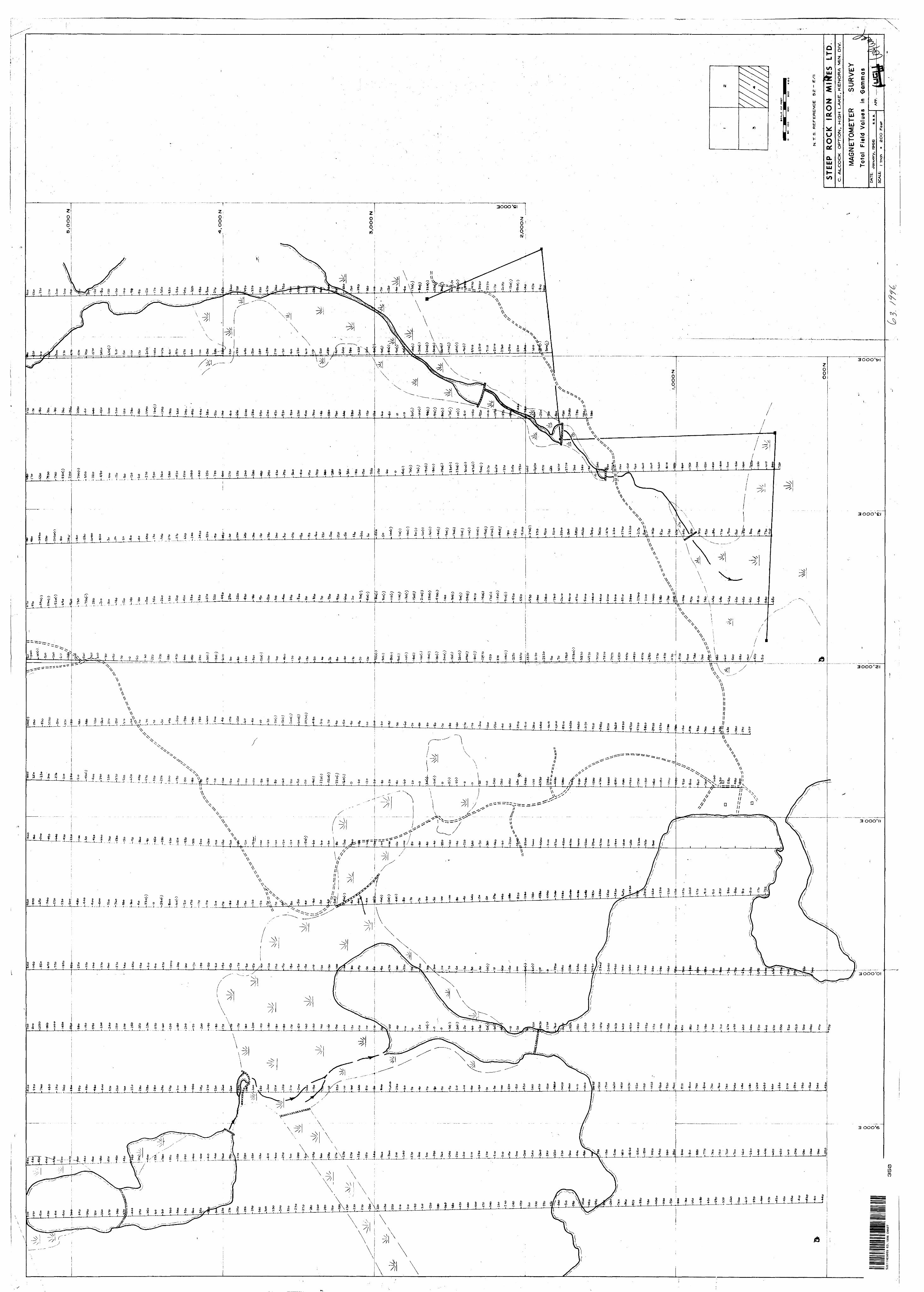
1
GO
ON
111 0 o o ft W
UJ
O
O O1
A '
10!
N.
T
S.
RE
FE
RE
NC
E
52 - E
/ll
STEE
P R
OC
K
IRO
N
Mlff
ES
LT
DC
. A
LC
OC
K
OP
TIO
N.
HIG
H L
AK
E,
KE
NO
RA
M
IN.
D\V
.
MA
GN
ETO
ME
TER
S
UR
VE
Y
Tota
l Fi
eld
Val
ues
in G
amm
asD
ATE:
Jan
uary
, 1966
SC
Atf
cI
inch
*
2OO
F
eet
AP
P:
S2E11NE9069 63.1996 EWART
350
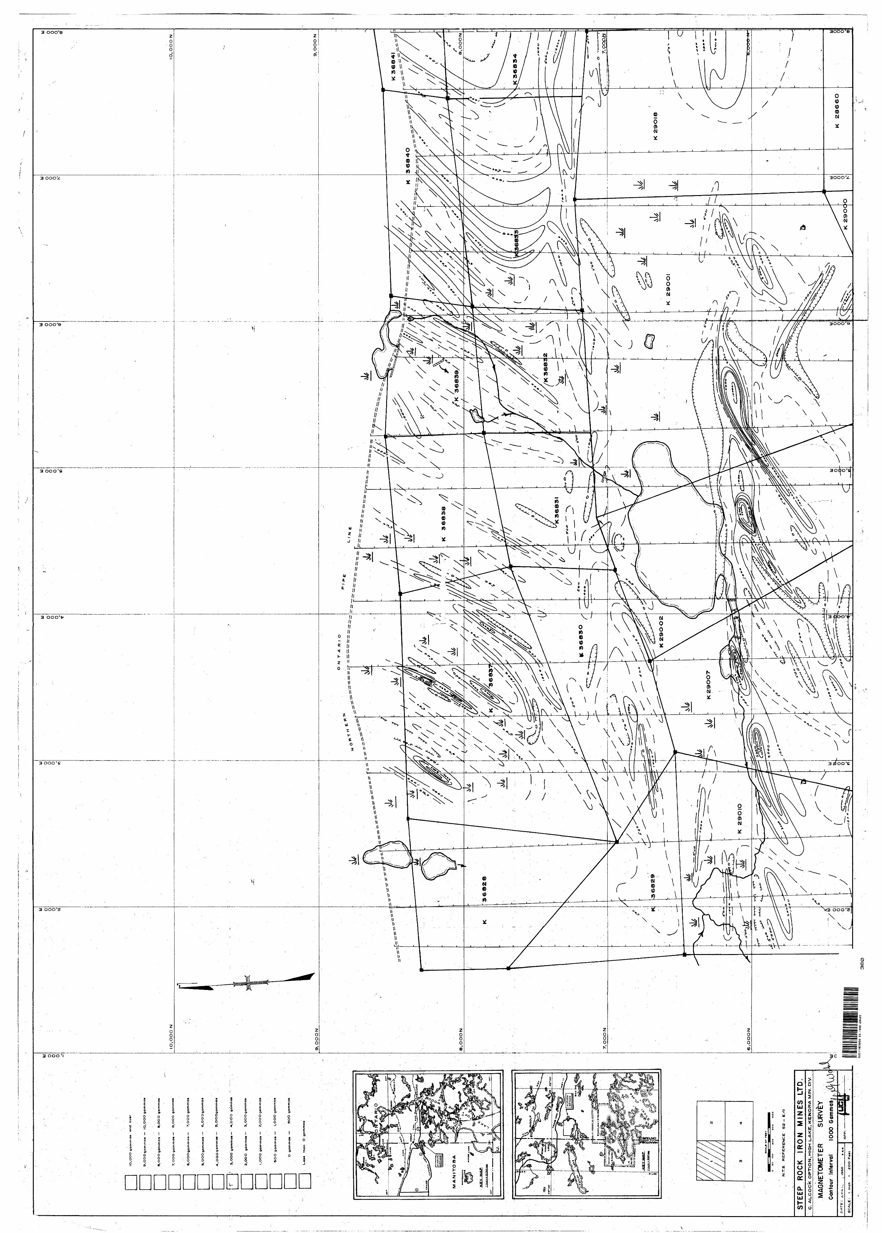
IO.O
OO
gam
ma*
on
a o
ver
9,O
OO
gam
ma*
—
to, O
OO
gam
ma*
8,O
OO
go
mm
a*
—
9.O
OO
gam
ma*
O.O
OO
NIO
.OO
O N
7, O
OO
gam
mas —
S
.OO
O g
am
ma*
G.O
OO
go
mm
a*
—
7,O
OO
gam
ma*
5,O
OO
gam
ma* —
6,O
OO
gam
mo*
3, O
6O
gam
ma*—
4
,'o
dO
g
amm
a*
2.O
OO
g
am
ma*—
3
, OO
O g
am
ma
*
t.O
OO
gam
ma*
—
Z,O
OO
gam
ma*
SO
O g
am
ma*
—
I,O
OO
ga
mm
a*
O g
am
ma
* —
S
OO
ga
mm
a*
U«»
« th
an
O
ga
mm
as
9,
OO
O N
9.O
OO
N
O
N
T
A
R 1
0
K 3
68^
1
K
36838
36839
S.O
OO
N
K 3
683^
4
K3683I
29
OO
22
90
0
29O
OT
S.O
OO
N
«CAU
C o
r•=
>o
so
too
. a
oo
so
o
N.T
.S.
RE
FE
RE
NC
E
52 - E
XII
STEE
P R
OC
K
IRO
N
MIN
ES
LT
D.
C.
AL
.CO
CK
OP
TIO
N,
HIG
H L
_AK
E, K
EN
OR
A M
IN.
Dty
K
28
66
O29
OC
'O
52E1INE9069 63.1996 EWART
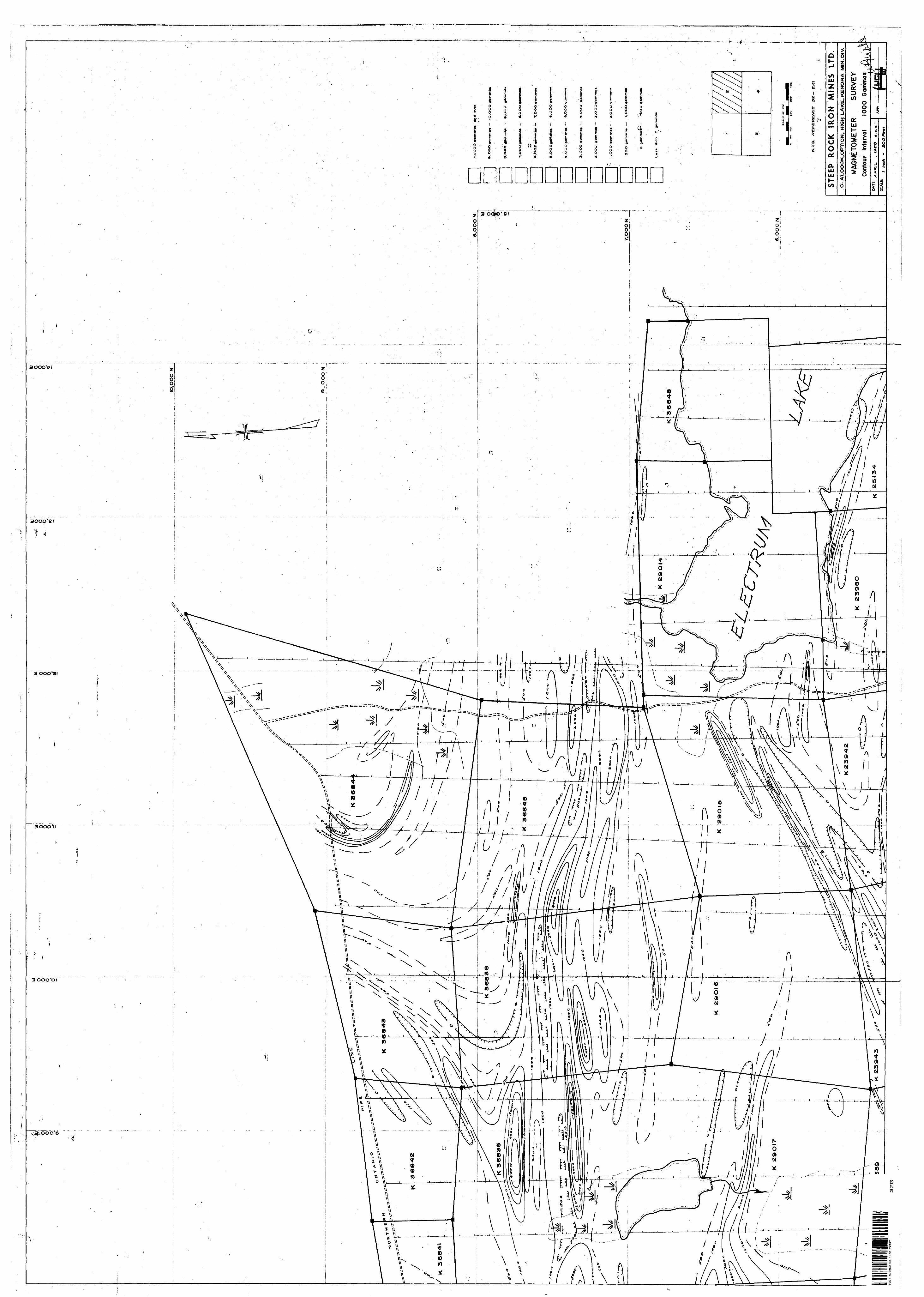
IO.O
OO
N
8,O
OO
N
36836
.OO
Oaa
mm
am —
i O
.
36835
368-4
5
S.O
OO
oom
mo*
6.O
OO
NU
E O
F
FM
T
i^
o so
to
o ao
o so
o
.rS
. R
EF
ER
EN
CE
S
Z- E
/lt
STEE
P R
OC
K
IRO
N
MIN
ES
LT
DC
. A
LC
OC
K,O
PT
ION
. H
IGH
LA
KE
, K
EN
OR
A
MtN
. O
IV
MAG
NET
OM
ETER
S
UR
VE
Y
Cont
our
Inte
rval
10
00
Gam
ma
23943
t In
ch
- 2O
OF
**f
S2E11NE9069
63.1996 EW
ART
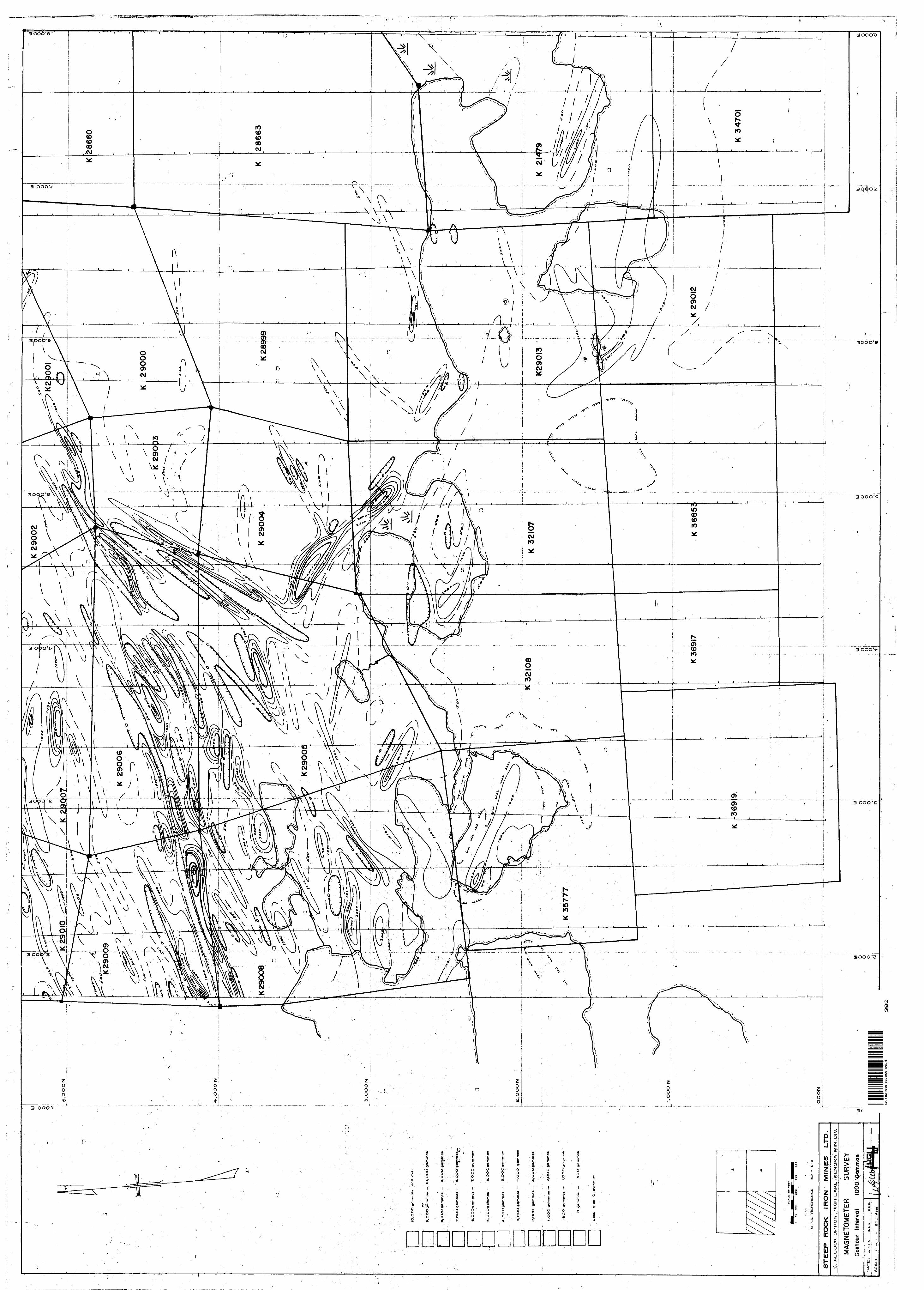
IO.O
OO
gam
rrla
* a
nd
o
v*r
Si,O
OO
go
mm
o*
—
JO.O
OO
ga
mm
a*
8.O
OO
gam
mas
—
9
.OO
O
7,G
OO
ga
mm
a*
—
S,O
OO
ga
mm
a**
*
6,O
OO
gam
ma*
—
T, O
OO
ga
mm
a*
5, O
QO
gam
mo
* —
6
, OO
Og
am
ma«
—
5,O
OO
ga
mm
a*
3,O
OO
ga
mm
a*
—
4,O
OO
g
am
ma*
2.O
OO
ga
mm
a*—
: 3,
OO
Ogo
mm
a»
l.O
OO
gam
ma*
—
Z.Q
OO
ga
mm
a*
SO
O g
am
ma*
—
l,Q
QO
garp
ma»
O
gam
ma*
—
SO
O g
am
ma
c
than
O
g
am
ma
s
N.T
.S.
RE
FER
EN
CE
sz
-
ST
EE
P
RO
CK
IR
ON
M
INE
S
LT
D.
C,
AU
CO
CK
O
PT
ION
,HIG
H L
AK
E v
KE
NO
RA
fy
llN.
DIV
.
MA
GN
ETO
ME
TER
S
UR
VE
Y
Cont
our
Inte
rval
10
00 g
amm
as
DA
TE
: A
PR
IL.
, 1966
52Et1NE9®69
63.1996 EW
ART
380
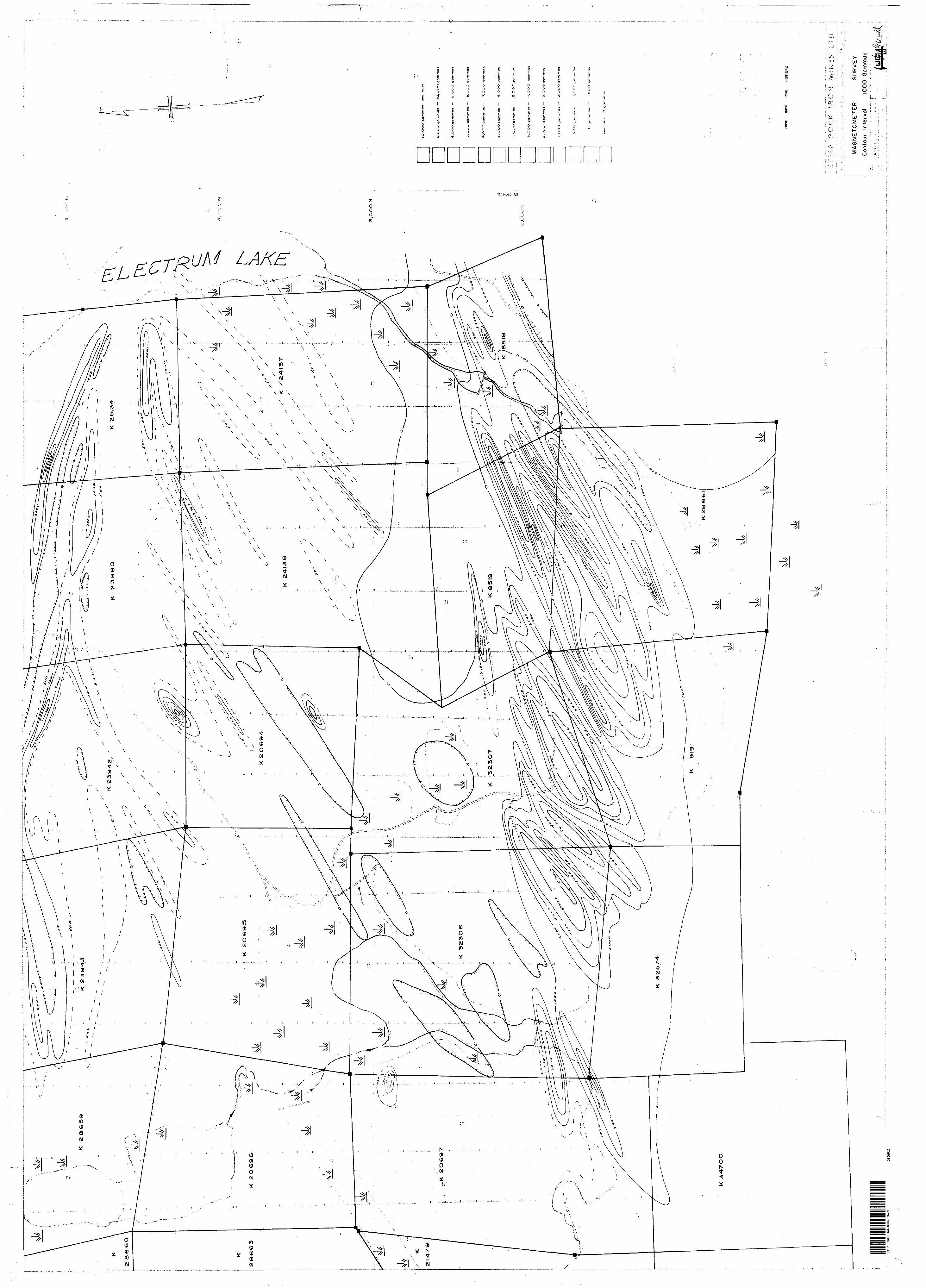
CO
O N
3,O
OO
N
U U 0 o in1,
OO
C -
^
lO.O
OO
g
am
ma
* a
nd
over
9.O
OO
gam
mas
—
1O
,OO
O g
am
mas
Q.O
OO
ga
mm
a*
—
9,O
OO
gam
mas
7.O
OO
ga
mm
as
—
S,O
OO
gam
mas
6.O
OO
ga
mm
as —
7.O
OO
gam
mas
S.O
OO
ga
mm
os
—
S
.OO
O g
am
mas
, O
OO
ga
mm
as —
5
,OO
Og
am
mas
3.O
OO
gam
mas—
1
.OO
O
gam
mas
2.O
OO
gam
mas—
3,O
OO
gam
mas
I , O
OO
gam
mas
—
2, O
OO
gam
mas
5O
O gam
mas
—
l.O
OO
ga
mm
as
O
ga
mm
as
—
5O
O
ga
mm
as
Uess
tha
n
O g
am
ma
s
MA
GN
ETO
ME
TER
S
UR
VE
Y
Con
tour
In
terv
al
1000
G
amm
as
52E
HN
69069
63.1
996
GW
ART
33
0
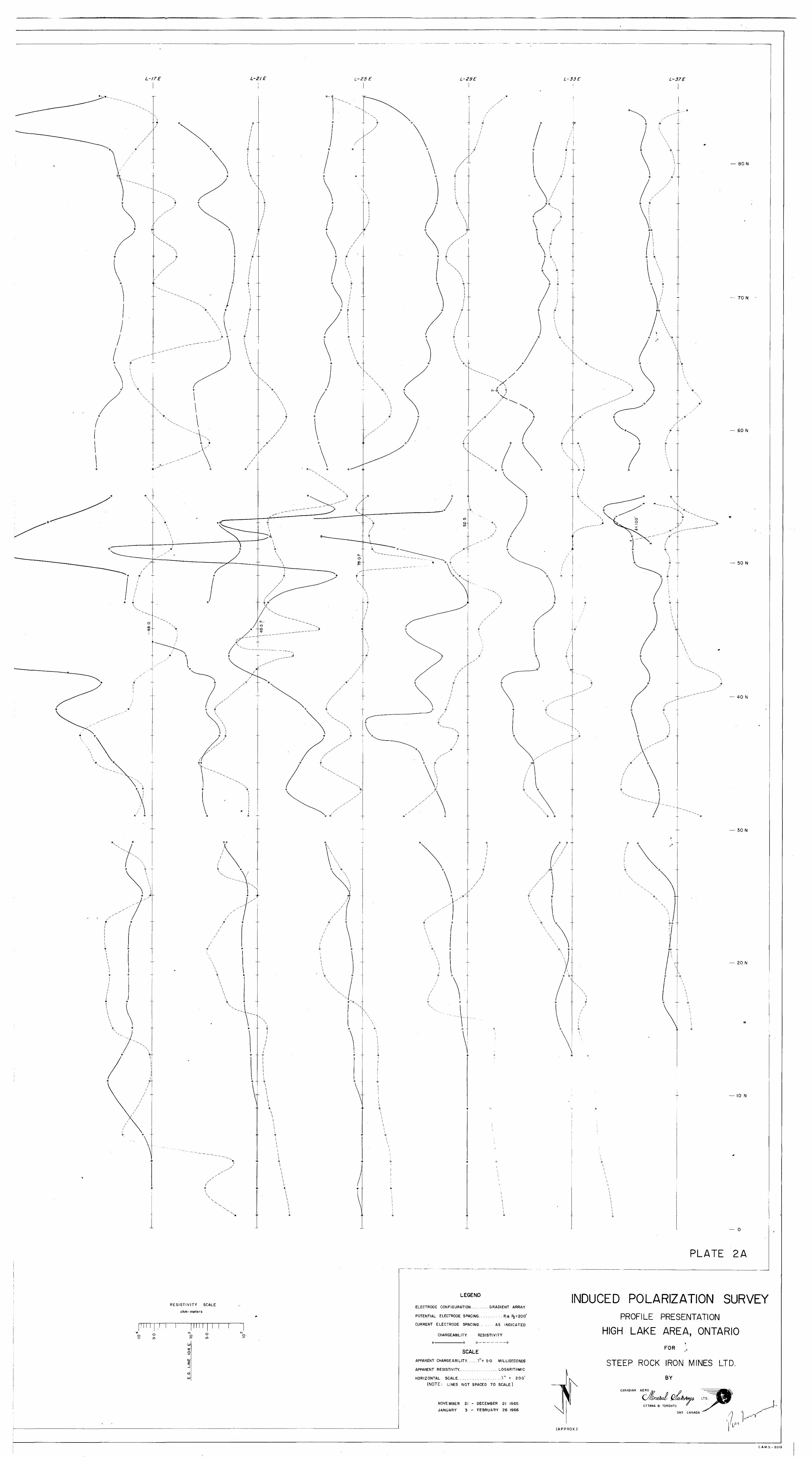
L-I7E L-2IE L-25 E L-29E L-33E L-37E
— 8 0 N
70 N
60 N
— 50 N
40 N
30 N
— 20 N
10 N
— 0
PLATE 2A
RESISTIVITY SCALE
ohm-meters
o 10
roo o
in
LEGEND
ELECTRODE CONFIGURATION ........ GRADIENT ARRAY
POTENTIAL ELECTRODE SPACING.. ........ P,a ^ = 200*
CURRENT ELECTRODE SPACING. ...... AS INDICATED
CHARGEABILITY RESISTIVITY
INDUCED POLARIZATION SURVEYPROFILE PRESENTATION
HIGH LAKE AREA, ONTARIO
SCALEAPPARENT CHARGEABILITY. .... l"= 5-0 MILLISECONDS
APPARENT RESISTIVITY.. ......... ...... LOGARITHMIC
HORIZONTAL SCALE.. .............. ..l" = 200*
(NOTE: LINES NOT SPACED TO SCALE)
NOVEMBER 21 - DECEMBER 21 1965
JANUARY 3 - FEBRUARY 26 1966
FOR
STEEP ROCK IRON MINES LTD.
BY
CANADIAN AERO
OTTAWA 8 TORONTO
ONT. CANADA
(APPROX.)
C.A.M.S.- 6019
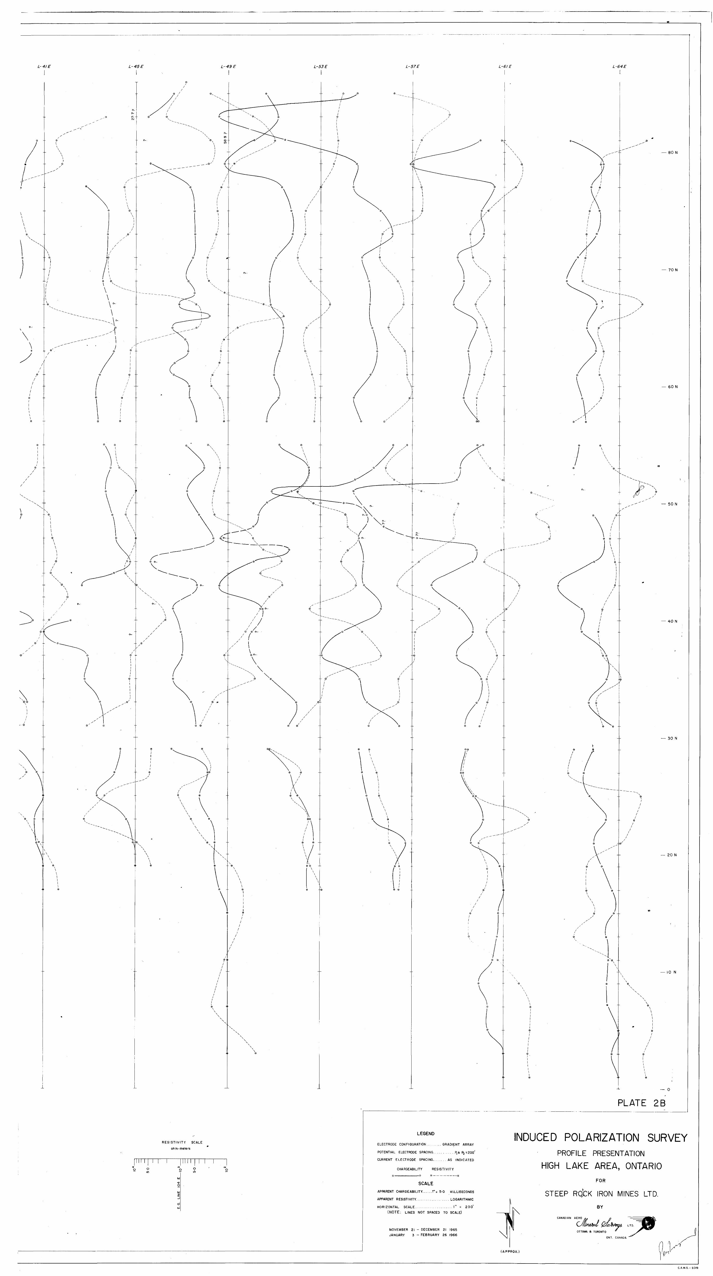
L-4/E L-45E L-49E L-53E L-57E L-61 E L-64E
o o
80 N
70 N
— 60 N
0--
50 N
© 0 --
o ©
0 -
— 40 N
— 30 N
20 N
— ION
0
PLATE 2B
RESISTIVITY SCALE
ohm-meters
9inwO
LEGEND
ELECTRODE CONFIGURATION......... GRADIENT ARRAY
POTENTIAL ELECTRODE SPACING.. ....... ..P,a P2 =200'
CURRENT ELECTRODE SPACING........ AS INDICATED
CHARGEABILITY RESISTIVITY
©—————————————————0 0_________@
SCALE
APPARENT CHARGEABILITY. .....!"= 5-0 MILLISECONDS
APPARENT RESISTIVITY. ................. LOGARITHMIC
HORIZONTAL SCALE...- ................ 1" = 200*
(NOTE: LINES NOT SPACED TO SCALE)
NOVEMBER 21 - DECEMBER 21 1965
JANUARY 3 ~ FEBRUARY 26 1966
INDUCED POLARIZATION SURVEYPROFILE PRESENTATION
HIGH LAKE AREA, ONTARIOFOR
STEEP RQ'CK IRON MINES LTD.
BY
CANADIAN AERO
OTTAWA a TORONTO
ONT. CANADA
APPROX.)
C.A.M.S.- 6019
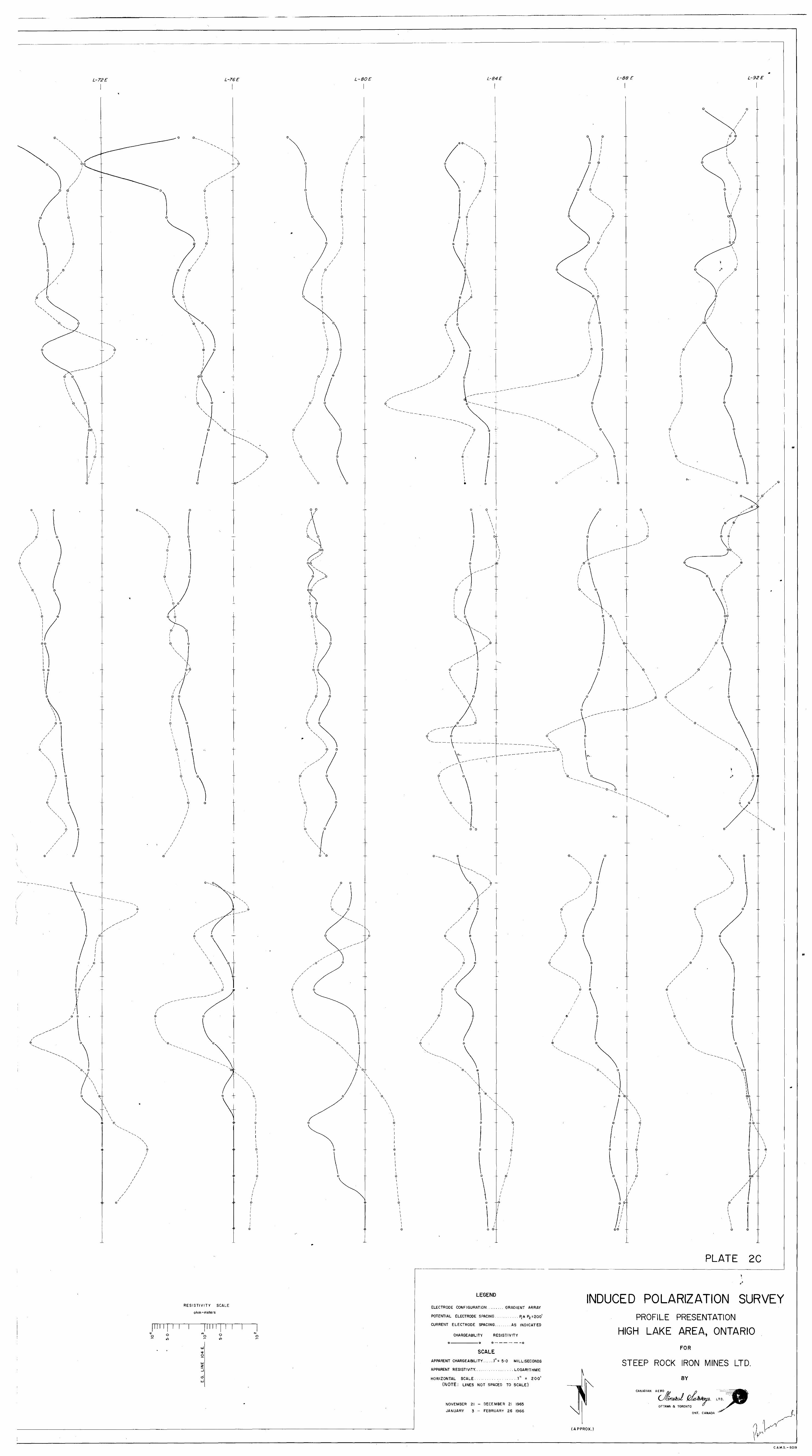
L-72E L-76E
\
0
O
-©'
N.
O
© ©
O O
O ©
O O
0 ©--
© ~-
O O
O
Q O
\
© O
©
©
e
RESISTIVITY SCALE
ohm-me1ers
oIT)
roO 9in
LU
O O
O
© O
o o
o o
0
o
\ 00
00
©O
0 O
© ©
© 0
L-84E L-88 E L-92E
o o.
Q O
/ o I
o
0 -
Q
Q\ \\ \
V \
V\ ©--
© o
Q © x
0 O -
©
\© © \ \
r©
O
X
o
G
Q
XV.
X
\ © ©
I
©--\
©
X
o.
\0 O\ \
\ \ \
oxo
0-
l/
O 0
0
O O
o o
O 0--
©
o
- o
©'
© o\
\ \ \
\ ©oI/
0 ©
\\
G \
X
X
.1\0
O 0 \
0
0 O
0
/ © ©
e o
\
0©
0
00\ \
\\\\ I 1
0©
I
©0
© /
©
X
PLATE 2C
LEGEND
ELECTRODE CONFIGURATION ........ GRADIENT ARRAY
POTENTIAL ELECTRODE SPACING .......... P, a P2 =200'
CURRENT ELECTRODE SPACING... .... .AS INDICATED
CHARGEABILITY RESISTIVITY
©- ———— . ——— © o — — — — — —©
INDUCED POLARIZATION SURVEYPROFILE PRESENTATION
HIGH LAKE AREA, ONTARIO
SCALEAPPARENT CHARGEABILITY.. . ...l"= 5*0 MILLISECONDS
APPARENT RESISTIVITY....... ......... . . LOGARITHMIC
HORIZONTAL SCALE .................. ,l" = 200*(NOTE: LINES NOT SPACED TO SCALE)
NOVEMBER 21 - DECEMBER 21 1965
JANUARY 3 - FEBRUARY 26 1966
FOR
STEEP ROCK IRON MINES LTD.
BY
CANADIAN AERO
OTTAWA a TORONTO
ONT. CANADA
UPPROX.)
C.A.M.S.-60I9