Embed Size (px)
DESCRIPTION
This booklet illustrates a series of urban design proposals on a sustainable urban corridor for Indianapolis, IN. (Composed by students in the Graduate Architecture/ Urban Design Studio, Department of Architecture, College of Architecture and Planning, Ball State University, fall 2009.)
Citation preview

Ball State UniversityJo Ann M. Gora, President
College of Architecture and PlanningGuillermo de Velasco Vasquez, DeanMichel A. Mounayar, Associate Dean
Department of ArchitectureMahesh Senagala, ChairStephen Kendall, Director of Master of Architecture ProgramJulie Kraztner, Programs Assistant
Project TeamHarry A. Eggink, ProfessorJared S. Burt, Student EditorAndrew M. Hesterman, Student EditorErin R. ChapmanMatthew FlammJennifer FlegelSteven A. HerronJason KlinkerKate D. LengacherBen McHughAdam D. MillerAllison MorlockRebecca A. StaleyLoaei ThabetAshley VanMeter
RATIO Architects, Inc. Bill BrowneDustin EgginkTom GallagherJohn Jackson Chunsheh Teo Sandra Yencho
Printing and BindingLulu Press Inc.


Urban algae CUltUre Matthew Flamm
PlUgging into Washington st. Erin R. Chapman
Contents:introdUCtion Harry Eggink
Creating CommUnity Jennifer Flegel
CommUnal layers Steven A. Herron
Urban FabriC Andrew M. Hesterman
the living line Jason Klinker
reConneCting the neighborhoods Kate D. Lengacher
inFiltrating e. Washington st. Ben McHugh
greenbelt gateWay Adam D. Miller
green revitalization Rebecca A. Staley
?????? Loaei Thabet
neW agriCUltUral Urban main st. Ashley VanMeter
transForming an ideal Jared S. Burt
06
08
14
20
26
32
38
44
50
56
62
68
74
80
revieW sessions86
6_introduction

IntroduCtIon:This booklet, on a sustainable urban corridor for Indianapolis, illustrates a series of urban design proposals from students in the fall semester Graduate Architecture/Urban Design Studio, Department of Architecture, College of Architecture and Planning, Ball State University.
The project began with the challenge of defining and redefining the urban design and the architecture of an inner urban core that lingers between a major downtown traffic feeder and an industrial railroad line. This urban mixed-use environment has been deteriorating for more than fifty years, where its physical health has been neglected, avoided, and misdirected, resulting in brown fields, abandoned factories, dilapidated neighborhoods, and a main corridor devoured by the automobile.
Briefly, the studio engaged a 2.25-mile section of the East Washington Corridor, Old US 40 (“the national road”) near the downtown in Indianapolis. Their objectives: to invent and design an urban sustainable contemporary environment. The studies began with a team process on a macro scale, with analysis, research and conceptual design and terminate with an individual interpretation of architectural form, space, and technology.
The studio integrated new sustainable urban layers into an existing dilapidated corridor pattern, reviving a fatigued city grid and retooling an outdated infrastructure; and created sustainable urban design strategies, based on transit-oriented developments, and contemporary urban living, working and recreational spaces.
The proposed architecture responds to the existing chaos of the linear fabric of Washington St. as “main street”, blends and integrates into the surrounding Indianapolis urban context, challenges the typical environmental solutions, and invents designs a contemporary sustainable physical layer for the corridor.
The adjacent drawings are critique sketches by Harry Eggink from the studio, representing the students’ design concepts and development images.
harry eggink_7

Transforming an ideal: A Flexible Community For the 21st Century
East Washington Street in Indianapolis, IN was originally part of the National Road that extended across the Midwest. Instantly communities began to form around this major road. Rail lines ran parallel to the street allowing industries to be located on both, while neighborhoods surrounded the workplace for ease of transportation. This development was based on the nature of people needing and wanting to live close to the workplace. However, as the highway system began to expand making transportation much easier people began to live further and further away from their workplace. Today billions of dollars are spent just to address this phenomenon when what we really need to do is rethink our
lifestyle that has been transformed by the automobile.
_ProposalOver the past few decades East Washington Street has gone from a thriving community full of industry surrounded by small neighborhoods, to a community starving for business because the industry has started to move further outside the city to expand on cheaper ground. Located less than a mile outside of Indianapolis’s downtown, East Washington has a huge amount of potential to revitalize its identity in the twenty first century. Its existence and condition has always been based around the new ideals for living and working which makes it logical to be a
candidate for a new type of living. For the first time we now have more people living in cities across the world than any other place. This shift has caused an increase in high-density living making our methods and forms of living and transportation. Currently an increase in population would mean an increase in automobile traffic. However, as we move closer to the city and farther from the suburbs, there becomes more opportunity for sustainable forms of transportation. The proposed development for East Washington Street address its rich history in transportation and living around your workplace as they did originally when the area was thriving, while integrating flexibility for current and future needs.
JAr
ed
s.
bu
rt
Transit Oriented Development

jared s. burt_9
10_transforming an ideal
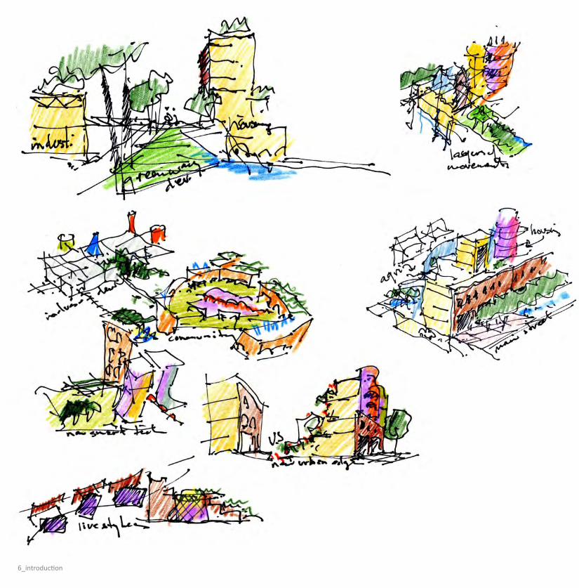
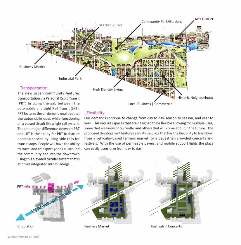
_FlexibilityOur demands continue to change from day to day, season to season, and year to year. This requires spaces that are designed to be flexible allowing for multiple uses, some that we know of currently, and others that will come about in the future. The proposed development features a multiuse plaza that has the flexibility to transform from a vehicular-based farmers market, to a pedestrian crowded concerts and festivals. With the use of permeable pavers, and mobile support lights the plaza can easily transform from day to day.
Business District
Industrial Park
Historic Neighborhood
Market Square
Arts DistrictCommunity Park/Gardens
Circulation Farmers Market Festivals | Concerts
High Density Living
Local Business | Commercial
_Transportation The new urban community features transportation via Personal Rapid Transit (PRT) bridging the gab between the automobile and Light Rail Transit (LRT). PRT features the on demand qualities that the automobile does while functioning on a closed circuit like a light rail system. The one major difference between PRT and LRT is the ability for PRT to feature nonstop service by using side rails for transit stops. People will have the ability to travel and transport goods all around the community and into the downtown using this elevated circular system that is at times integrated into buildings.
PRT
jared s. burt_11

12_transforming an ideal
Living Machine
Business | Industry
Residential
Circulation
Personal Rapid Transit (PRT)
Commercial | Retail
Prefabricated Hollow Core Slab
Steel Beam
HVAC System
Drop CeilingGreen Wall / Living Machine
Drip Irrigation / Living Machine
Stack VentilationExterior Glazing
_Live Work Originally people settled in small neighborhoods around the industry, but with the new high-density demands of the future, people will now have the opportunity to live within their industry or business. Combining the functions of living and working allows for less time spent commuting, as well as 24 hour activity eliminating on and off peak hours that typical business districts face.
_Sustainability Sustainability and integrated “Green” principles are becoming closer to being an industry standard for new construction. This includes everything from the efficiency of materials used, to the management of environmental elements such as water. The proposed development features an integrated living machine that would not only collect rain water, but also all the water that was used within the building. The waste water is collected and filtered through a series of bacteria tanks, then used as irrigation for the green wall system for further filtration. The excess, purified, water is then collected at the bottom of the wall and reused throughout the building.

jared s. burt_13
Personal Rapid Transit (PRT)- Nonstop Service- On Demand Loading- Access to Downtown and Surroundings
Underground Parking
Flexible Plaza- Farmers Markets- Concerts- Picnics- Festivals
Operable Shutters- Provides Privacy- Blocks Sound and Light- Resident Controlled Facade
Rain Water Collection- Minimizes Storm Water- Filtered Through Living Machine- Reused for Grey Water
Wind Turbine
Light
Electric Outlets
Removable Canvas
Attachment to the Electric GridRemovable Aluminium Pole
Base Key
Grass Lawn
Permeable Paver
Support Base
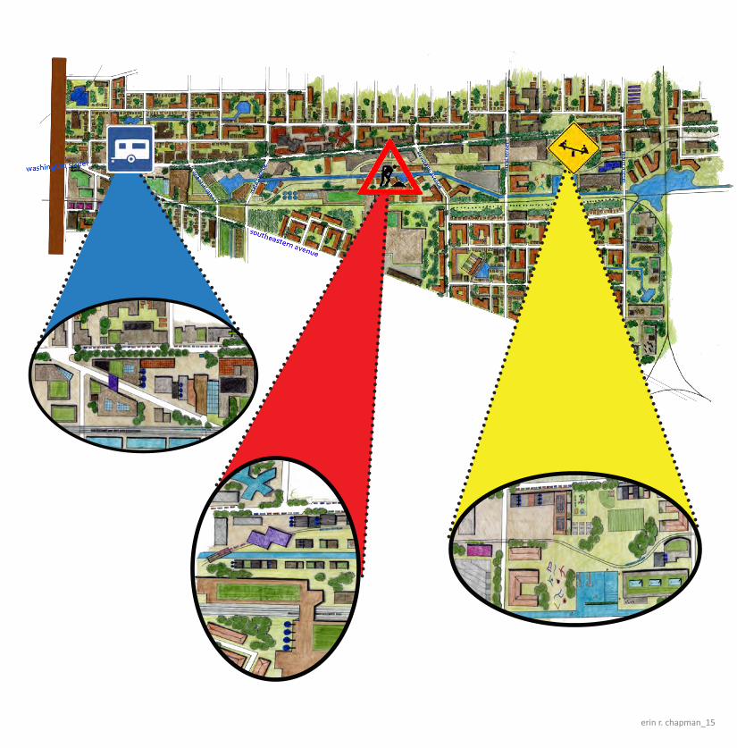
Plugging into Washington st: Revitalizing east of the city
It takes more than a desire to fix a dilapidated part of town. It needs to be a commitment to providing identity to a place as well as providing a source for vitality. The concept behind the East Washington street revitalization is a clear step process meant to ensure identity and vitality on the east side of Indianapolis.Within the two and one half mile strip along Washington Street there are numerous issued that need to be addressed. Trapped neighborhoods segregated between high trafficked roads and rail lines, large abandoned factories, homes falling apart, lack of life, unsafe spaces for children to gather, and no hope in sight just begin to skim the surface of the problems within Washington Street. In my design, I created three distinct districts that would give the community a sense of identity and purpose. Having three main stops along East Washington Street also breaks up the long, monotonous street designed around the automobile and harsh asphalt.
The first section right east of the 65/70 Interstate is the LIVE district. Here there is a high density of residential units, as well as local commercial conveniences within a five minute walk. Mixed use buildings would flank the sides of Washington Street to enforce a traditional style neighborhood and promote walk-ability along the street. There would be generous amounts of accessibility to the public transit (light rail) that would allow people living in this district to transport to work downtown quickly and efficiently. The WORK district would create dwellings close to the work environments. Here homes and spaces would the require the ability of work as well as relaxation. Short commute times by living near the workspace would promote a walkable community that is not driven by automobiles. Abandoned factories would be converted into a primary source of income for the community. Steel mills would fabricate new modular units for dwellings throughout the east side of Indianapolis. These new
homes would replace dilapidated homes throughout the area and would provide a new modern identity and vitality. In addition to the steel mills, there is a proposed energy facility that would convert waste products into an energy source to power the mills and neighboring homes and businesses for a greener lifestyle.The PLAY district has a variety of different buildings, fields, and activities. First, old factories could be converted into apartment style buildings to create a “warehouse district” that provides character from the historic US 40 highway, a time when Washington Street thrived. In the play district, there would be a focus on community, where dwellings would push residents to get out into the community and interact with each other. Large open fields would provide space to play football, soccer, or lacrosse, baseball fields and basketball courts are also available. A pool or place to sail, numerous bars, theater venues, and other activities help to promote this community involvement.
eRin
R.
cha
PM
an
erin r. chapman_15

16_plugging into washington st.
TRANSPORTATION:Throughout the existing site, it is hard to travel from one side of Washington Street to other and then across numerous railroad tracks without feeling intimidated by the automobiles. To help with the vehicular traffic, I propose to reduce travel lanes along Washington Street, add trees along the street, and provide on-street parking. These street calming tactics will slow traffic speeds and make walking along the street less intimidating to the pedestrian. This in turn will encourage people to return to the street and bring along with them vitality and character. The below section is an example of what Washington Street might look like after the makeover.As mentioned before, Washington Street and the railroads produce a number of trapped neighborhoods. The proposed movement will be enforced in a variety of four different transportation indicators. First, specific existing roads will be enhanced to connect neighborhoods North and South of the railroad tracks. This will be an indicator for people to cross the tracks at these designated points.
These specific points will also slow train traffic down, for there will be a heightened awareness of automobiles crossing the tracks. Secondly, is the importance of the train tracks within the site. There is a strong East and West flow of train travel throughout the site. This industrial rail will provide residents with the option of using the rail for long distance travel. Also, with the rail cutting through the main steel mill industrial area, once modular units are complete, they can be loaded onto the train and can be sent virtually anywhere in the United States to help revitalize other neighborhoods. Third, and very important to the mass movement of people on a daily basis is the light rail system. The light rail system follows the industrial rail into the site, and the proceeds to split off and weave in and out between Washington Street and the railroad. By having the rail weave back and forth, it hits major stopping points so residents can easily access the line and head downtown to work for an easy commute. Lastly, is the water system. Having a large canal system will allow for water travel within the site. This will
Vehicular Paths
Industrial Rail Paths
Public Transportation Paths
Water Travel Paths
erin r. chapman_17
also be used for water collection and retention.
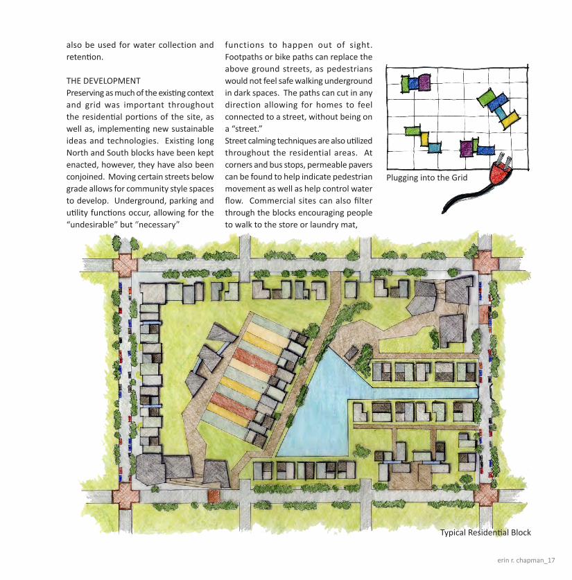
THE DEVELOPMENTPreserving as much of the existing context and grid was important throughout the residential portions of the site, as well as, implementing new sustainable ideas and technologies. Existing long North and South blocks have been kept enacted, however, they have also been conjoined. Moving certain streets below grade allows for community style spaces to develop. Underground, parking and utility functions occur, allowing for the “undesirable” but “necessary”
functions to happen out of sight. Footpaths or bike paths can replace the above ground streets, as pedestrians would not feel safe walking underground in dark spaces. The paths can cut in any direction allowing for homes to feel connected to a street, without being on a “street.” Street calming techniques are also utilized throughout the residential areas. At corners and bus stops, permeable pavers can be found to help indicate pedestrian movement as well as help control water flow. Commercial sites can also filter through the blocks encouraging people to walk to the store or laundry mat,
Typical Residential Block
Plugging into the Grid

18_plugging into washington st.
instead of taking their cars. These commercial sites can also create plaza spaces for community gatherings.
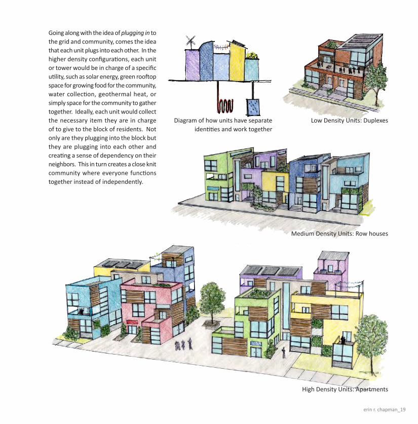
THE ARCHITECTURESince all of the residential blocks are pre-wired or equipped with all necessary utilities, housing patterns can develop in a variety of ways and then plug in to receive water, electricity, and heat. For example, sun angles can be taken advantage of for optimal energy conservation without disrupting the preexisting grid street pattern. The steel mills are meant to increase residential density to the area to help bring back a sense of community. By having a factory create modular units, transport them to the local site, and then be assembled in a variety of ways, residents of this area can afford to purchase homes or apartments at a reasonable cost without having a cookie cutter line of homes with no personality.
The modular spaces created are similar to the growing trend of living within shipping containers. Shipping containers are all the same size and can fit together in a variety of patterns, plus they bring a sense of character and color to the table. The same goes for these modular units that are in-filling the Washington Street neighborhood. The main units can push and pull into a variety of patterns creating unique spaces within them. Porches and alcoves can become personalized and small additions can be made to fit the needs of the residents. Ideally, no two units should be the same. Ranging from low density single family dwellings to high, mixed-use densities, families can determine which unit is within their budget. Since the residential blocks have no specific set up, a single family home can be located right next to multiple unit apartment buildings. This mixture creates a sense of unity among different class ranges, focusing on the identity of the community rather than the sole advancement of one group or family.
Building Block Patterns
Diagram of how Industry/Energy work within the community
Low Density Units: Single family homes
erin r. chapman_19
Going along with the idea of plugging in to the grid and community, comes the idea that each unit plugs into each other. In the higher density configurations, each unit or tower would be in charge of a specific utility, such as solar energy, green rooftop space for growing food for the community, water collection, geothermal heat, or simply space for the community to gather together. Ideally, each unit would collect the necessary item they are in charge of to give to the block of residents. Not only are they plugging into the block but they are plugging into each other and creating a sense of dependency on their neighbors. This in turn creates a close knit community where everyone functions together instead of independently.
Diagram of how units have separate identities and work together
High Density Units: Apartments
Low Density Units: Duplexes
Medium Density Units: Row houses
Urban algae CUltUre: GraftinG industry
East Washington Street has undergone a gradual transition from its prominence as the route of the National Highway into Indianapolis to a current state of under utilization. East Washington Street and a parallel rail line originally supported the movement of supplies and goods to and from the many industrial establishments that anchored the site. Since that time, the gradual outward progression of urban development has drawn the majority of residents and businesses away from the core of downtown to the suburbs. As a result of this exodus from the city center, the two mile stretch of East Washington Street just outside downtown has become a vacuum of grey and brown field sites. Although the majority of the subdivisions skirting the street are still maintained, it is apparent that the area no longer provides the strong job marked that it once did. In response, I am proposing the creation of a new creative class economy centered on the production of biodiesel derived from growing algae. Algae based Biodiesel
has an outstanding opportunity for implementation in urban settings not only because it has the potential to revitalize graying industrial areas, but because, as a gasoline substitute it can serve as an intermediary source of power for vehicles as our society transitions away from a car dependent urban structure.
When compared to conventional sources of biomass such as corn and switch grass, algae can be five times more productive due to the fact that it can grow year-round, does not occupy prime agricultural land, and can be grown using grey water. All of these factors make algae well suited to be grafted into the broken industrial infrastructure of Washington Street. Washington Street can be considered an incubator for the development and improvement of algae Biodiesel technology. Once the processes and knowledge base is established, the model can be exported for insertion into other under utilized urban environments.
The Biodiesel industry proposed for East Washington Street is organizationally split between an industrial production area, and an academic research laboratory. These two concentrated nodes distanced by over a mile along Washington Street serve as the bounds of the initial implementation of the urban algae culture. The production node of the development located on the western end of Washington Street near downtown Indianapolis is integrated with the existing east – west rail line allowing the convenient import of equipment and materials, as well as the export of market ready products and by-products. In contrast the eastern research node of the development is focused on the cultivation of an algae related knowledge base grounded in the fields of chemistry, biology, horticulture, and engineering. The constant flow of people, materials and ideas between the production and research nodes will form the framework of an emerging creative class economy on East Washington
Ma
tt
he
w f
la
MM

matthew flamm_21
indianapolis Context Map
washinGton street larGe area plan
22_urban algae culture
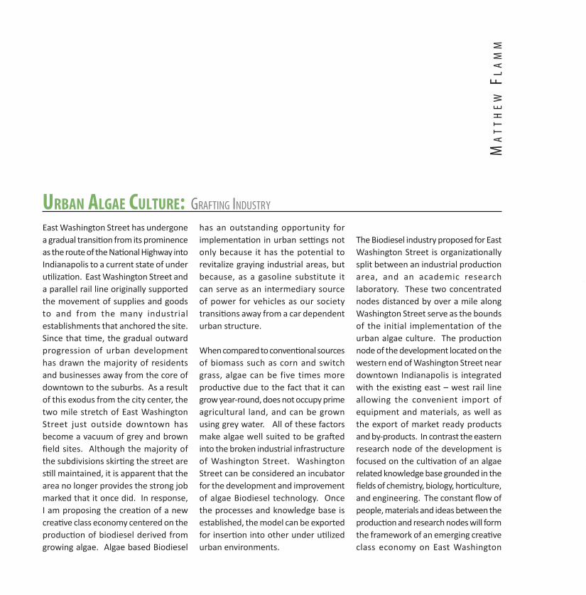
alGae Based Biodiesel produCtion proCess
Grey water is collected from roof tops, landscaping, and parking lots, as well as residential and industrial processes, and filtered through a living machine to ensure a consistent composition. An algae culture is introduced to the water, which is pumped into a series of evacuated glass tubes called photo bio-reactors, which operate similarly to solar hot water heaters. These reactors are mounted in a sunny area, supplied with an abundant amount of carbon dioxide, and allowed to undergo photosynthesis for about a week. The algae culture within each tube consumes the carbon dioxide and nutrients in the grey water as it duplicates itself, and produces more biomass. After the determined amount of growth time, the algae is pumped out of the tubes, and broken down, either by mechanical means (drying and grinding) or chemically (with the introduction and evaporation of solvents). The biomass is then processed in the same manner as other bio-fuels in a refining plant.
biodiesel ProdUCtion

matthew flamm_23
sMall area plan

24_urban algae culture
The small area plan is an investigation of the application of the algae production process to a series of commercial bui ldings. A panel ized canopy superstructure supported by piers provides an unconditioned human scale covering for retail space. The roof of the canopy serves the dual function of collecting rain water to be used for algae growth, as well as providing an armature on which to mount a large array of photo
Urban algae CUltUre:
detail: sMall area plan
bio-reactors. The shallow slope of the canopy funnels rain water down toward a collection cistern and a living machine. This filtered water is later pumped back onto the canopy in the algae tubes. The canopy also creates visual boundaries that form a series of urban shopping plazas. These plazas are accented with sculptural wind turbines that produce electricity to illuminate the algae arrays at night, sustaining their photosynthesis
at all times. This grafted algae industry is not limited in its application to this site on Washington Street, Indiana, or this region of the country. The beauty of algae is that each cell contains a complete package of instructions for its continued duplication. The technology of algae based Biodiesel, once proven on Washington Street, can be duplicated on a wide variety of scales and locations in our built environment.

matthew flamm_25
day tiMe MetaBolisM
niGht tiMe MetaBolisM
Redefining east Washington stReet : Creating Community
One of the biggest elements lacking at the site of East Washington Street in Indianapolis, Indiana, is the sense of community and connectivity. This is the main driving factor guiding the solutions for this project.
Existing Conditions & Site AnalysisThe site includes physical and social boundaries separating two distinct areas, which are hardly considered neighborhoods. East Washington itself, along with the railroad system, form the physical boundaries ultimately producing two distinct residential districts which do not co-mingle. The road blocks the movement from the north and south sides of the street. The railroad is another factor adding to the idea of separation, limiting north and south travel and further emphasizing the physical and social limitations. The railroad is surrounded by abandoned and dilapidated manufacturing and industrial buildings, although some are still in production and are utilizing the railroad.
The current street conditions foster little interaction between street, building, and pedestrian. It is void of visual coherence, excitement, and connectivity, resulting in the lack of community. The area is also without a pronounced sense of street and architecture. Existing traffic primarily included commuters into and out of Indianapolis. Currently it is a thoroughfare for vehicular traffic with little pedestrian activity.
Many of the houses are in need of repair, while others are beyond repair and may require demolition. They are placed very close together and create the only sense of density on the north and south sides of the street. Many properties immediately on the street are neglected or empty, filled with trash, debris, or cars. An overwhelming number of parking lots line the street, but East Washington Street lacks activities to bring people into this area. There are few stable and established local businesses for the people living within this area.
Surrounding the city are several p ro m i n e n t c o m m u n i t i e s a n d neighborhoods, all connected by the Indianapolis Cultural Trail. However, East Washington Street is not included and does not reflect a community feel.
Solutions & Master PlanThree main concepts are included in the master plan to improve East Washington Street and the surrounding areas. The first is to connect the two sides of the street with visual and physical connections. The second is to create nodes and areas of activity to build interest and foster a sense of community. Finally, the third is to improve the area using sustainable concepts and design elements.
Currently, the main green space is located on the south side of the street at Willard Park. Two other green spaces are also nearby, at opposite edges of the site. Including a physical link will connect both sides of the street and will provide a pedestrian route to allow
Jen
nif
er
fl
eg
el

jennifer flegel_27
View looking at main entry of Washington Crossing Community Center
from East Washington Street.

28_creating community
465
65
70
69
65
465
7470
74
Project Site Along East Washington Street in Indianapolis, Indiana
Existing Traffic Routes-Primarily Vehicular Traffic
Master Plan Design Concepts -Linear Parks and Nodes
N
Master Plan Design Concepts Modified Traffic Routes
I-65/70 StateAvenue
R u ra l Street
ShermanDrive
WillardPark
Highland Park
Christian Park
EastWashington
Street
RR
SoutheasternAvenue
ease of travel and linear parks. It will be similar to the Monon Trail which connects many cities and suburbs of Indianapolis. Another way to create connectivity is to bring the Cultural Trail into the East Washington Street area, which will be called Washington Crossing. This will create a physical and social link back to the city of Indianapolis. Additionally, visually appealing streetscapes should be incorporated into the design which will include tree lined boulevards, fixed and movable seating, and large sidewalks to allow for a number of activities and social gathering opportunities. This makes
st rong v i sua l connect ions and cohesiveness for the new community. Creating nodes and clusters of activity will aid in blurring the physical and social boundaries. It will provide a destination among areas of mixed use clusters of residential, business and commercial, and recreational aspects attracting outsiders as well as potential local businesses and residences. Each node should have its own identity, but should also reflect the overall idea of Washington Crossing as a whole. The key to the nodes is the visual access to the street and the interesting experience it establishes.
Lastly, the idea of incorporating sustainable elements begins even before the development of new construction. Each existing structure to be demolished will be deconstructed and the materials will be reclaimed. The reclaimed materials will then be used within the community for new structures. This reflects the idea of reducing, reusing, and recycling. The Willard Park expansion not only physically bridges and connects both sides of the street, but it shares a symbiotic relationship with the community by providing energy using wind turbines and geothermal technology.
jennifer flegel_29
Master PlanN
Area of Development
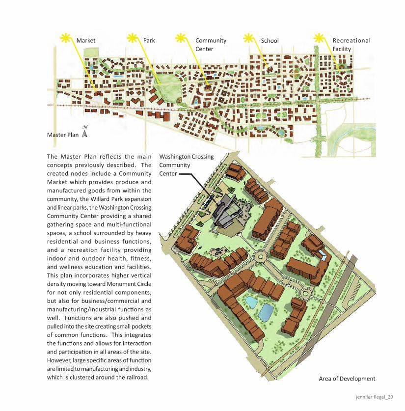
The Master Plan reflects the main concepts previously described. The created nodes include a Community Market which provides produce and manufactured goods from within the community, the Willard Park expansion and linear parks, the Washington Crossing Community Center providing a shared gathering space and multi-functional spaces, a school surrounded by heavy residential and business functions, and a recreation facility providing indoor and outdoor health, fitness, and wellness education and facilities. This plan incorporates higher vertical density moving toward Monument Circle for not only residential components, but also for business/commercial and manufacturing/industrial functions as well. Functions are also pushed and pulled into the site creating small pockets of common functions. This integrates the functions and allows for interaction and participation in all areas of the site. However, large specific areas of function are limited to manufacturing and industry, which is clustered around the railroad.
Market Park CommunityCenter
School Recreational Facility
Washington Crossing CommunityCenter

30_creating community
Summer Sun Diagram Winter Sun Diagram Air Movement Diagram
View of south approach from Green Trail
View of Entry Plaza & Water Feature
View of Event Plaza & Green Roof
A grid change has been introduced into the Master Plan, which is perpendicular to Southeastern Avenue. This creates much needed access from areas south of East Washington to areas north of East Washington. The Washington Crossing Community Center has been placed within the grid, allowing visual and physical access to all areas of the site.The Community Center is surrounded my medium density residential, commercial, and small industrial buildings. The architecture in this area uses the two grids to create the form of each building, reflecting the characteristics of the site. The site retains visual and physical access.
Views of the community center can be seen from the Green Trail at the south end of the site. The Cultural Trail passes along the north end of the center.This building becomes a statement piece and design criteria for the community. It provides multi-functional and flexible spaces which can be used for a variety of events and purposes. The exterior spaces along the north side are intended to act as gathering spaces for its users. Located along East Washington Street and the Cultural Trail, it allows easy access into the site and into the heart of the community. The exterior spaces at the south end of the building are event spaces as well.
The Event Plaza may be used for small concerts, festivals, weddings, etc. The sculpture and landscape garden displays local art and gardening features. Sustainable elements are incorporated into the design. Along with passive lighting and ventilating systems, it also provides active systems with the use of photovoltaic panels. Light wells and the extensive use of glazing allows indirect light to flood each space. Exterior sun shading devices are strategically placed at windows to block the harsh summer sun from entering the spaces directly. Traditional and contemporary materials are also used to create visual interest.
Washington Crossing Community Center
Design Considerations

jennifer flegel_31
1
2
19
4
5
67
8
9
10
1112
131415
16
17
18
24
20
2122
233
Washington Crossing Community Center
Exterior Spaces
View of Surrounding Streetscapes
GreenRoof
EventPlaza
Sculpture & Landscape
Garden
PhotovoltaicPanels
Entry Plaza & Water Feature
Plan N
Actual N
1 Vestibule2 Event Listing & Permanent Display3 Information Desk4 Office5 Learning & Activities Center6 Men’s Restroom7 Women’s Restroom8 Electrical Room
9 Gallery / Exhibits, Typical10 Storage & Green Roof Access11 Production Studio12 Stairs to Parking & Services Below13 Vestibule14 Multi-Purpose Room A15 Multi-Purpose Room B16 Storage
17 Mechanical Room18 Retail Booths19 Vending20 Women’s Restroom21 Janitor’s Closet22 Men’s Restroom23 Kitchen24 Elevator
Lower Level includes parking and additional spaces for building services and utilities.
View of north entry from East Washington Street
Floor Pan

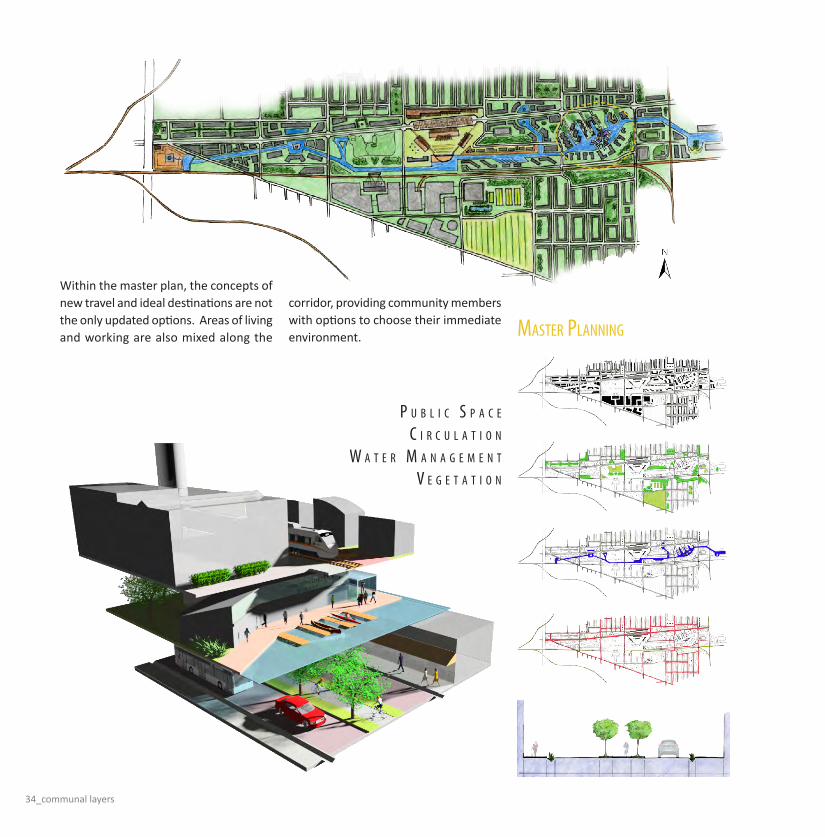
Communal layers: Providing oPtions For EvEryonE
When passing through Indianapolis’s east-side, it is fairly obvious that the Washington Street corridor is in desperate need for some type of revitalization. The community once gathered to restore the local park, Willard Park, and successfully created a pleasant area along the four-lane road once considered a main stretch of highway. The initial focus of the master planning phase was to create more areas and spaces along the corridor to compliment the uplift of Willard Park. Some of these spaces would be small gathering areas like business plazas or neighborhood gardens, while others would be communal destinations such as outdoor amphitheaters, farmers markets, and multi-functional community centers.As the diagramming and placement of these activities and destinations progressed, the need for a transportation upgrade became more prevalent. The rail lines that run parallel to Washington Street are an ideal solution to this transportation problem. The lines
would be shared with the industry to provide community members the opportunity to take a rail car into the downtown Indianapolis area, and leave their personal automobile at home. This would hopefully become a new, and more preferred, means of transportation both to and from anywhere in Indianapolis. Not only did the community need a new means of transportation to help jumpstart a new way of living for Indianapolis as a whole, but it also needed a revisit to the structure of the already dominating automobile traffic. A new streetscape that created “lanes” for all types of mobility – walking, driving, riding, or bicycling – would respond to the community in a more welcoming way, rather than directing all other types of “traffic” around the automobile. This streetscape would also have an environmental purpose, by adding to the landscape and the water management of the community. The buffers between people, bicycles, and automobiles would be areas for
trees and plants to create a softer and safer image of the street. Also, instead of using the underground grey-water system, the new streets would be able to control and manage water runoff and direct it all towards some type of filtration system or buffer. This would give the community control of water retention during heavy rains and provide them with the option of water re-use. As the water management concept grew, the idea of further control gave the master plan an overall theme – the addition of an “active canal”. This canal would be considered active because it is not used solely as an aesthetic piece to the community. Portions of the canal would be deeper and would consistently be holding water, while other portions are shallower and would more often be full of water only after a heavy rain. The canal would also stretch the entire length of the Washington Street corridor that this project is developing, providing yet another optional means of transportation.
stE
vE
n A
. H
Er
ro
n

steven a. herron_33
34_communal layers
MAstEr PlAnning
P u b l i c s P A c E
c i r c u l A t i o n
W A t E r M A n A g E M E n t
v E g E t A t i o n
Within the master plan, the concepts of new travel and ideal destinations are not the only updated options. Areas of living and working are also mixed along the
corridor, providing community members with options to choose their immediate environment.

steven a. herron_35
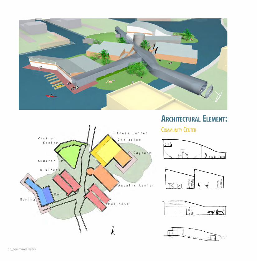
urbAn dEvEloPMEnt
As the master planning continued to develop, the next phase of design was to focus on one of the particular areas, or destinations that this concept initially created. An area of living, working, traveling, and playing was an ideal location for this focus. The chosen urban
development is surrounded by all modes of transportation, all types of businesses, and infilled with mixed-income and multi-family housing. All of this is grounded by a multi-purpose community center located on a central “island”.
36_communal layers
Business
Aquatic Center
Gymnasium
Daycare
Auditorium
Visitor Center
Fitness Center
Business
MarinaBar
coMMunity cEntEr
arChiteCtural element:
steven a. herron_37
M u l t i - F u n c t i o n
c o M M u n i t y c o n n E c t i o n
c i r c u l A t i o n
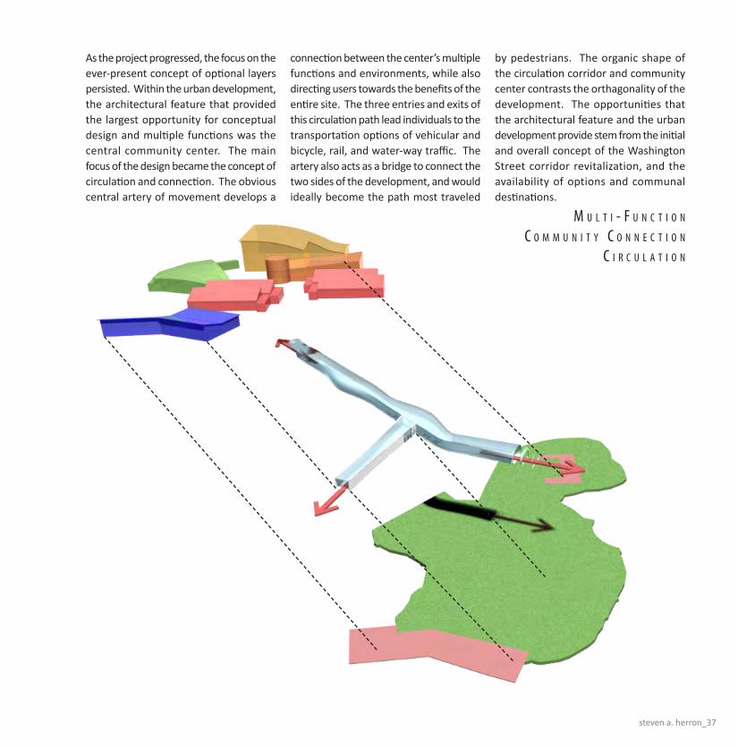
As the project progressed, the focus on the ever-present concept of optional layers persisted. Within the urban development, the architectural feature that provided the largest opportunity for conceptual design and multiple functions was the central community center. The main focus of the design became the concept of circulation and connection. The obvious central artery of movement develops a
connection between the center’s multiple functions and environments, while also directing users towards the benefits of the entire site. The three entries and exits of this circulation path lead individuals to the transportation options of vehicular and bicycle, rail, and water-way traffic. The artery also acts as a bridge to connect the two sides of the development, and would ideally become the path most traveled
by pedestrians. The organic shape of the circulation corridor and community center contrasts the orthagonality of the development. The opportunities that the architectural feature and the urban development provide stem from the initial and overall concept of the Washington Street corridor revitalization, and the availability of options and communal destinations.

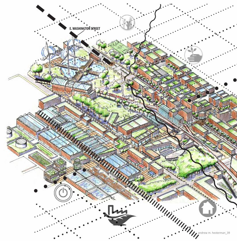
Urban Fabric: Layers of InnovatIon, IntegratIon, and sustaInabILIty
A tapestry is a woven whole. A quilt is patched together. The material make-up and stitched integration of layering elemental parts comprises a working system of unique and distinct pieces that become a complete idea. The idea is concrete, but may also be abstracted, added to, and adapted in design. Pieces of the work may become mobile and some stitchwork may be fast, slow, crafted, or mass-produced. When elements change, the system changes. When the original system fails, there is opportunity for revitalization, innovation, and pattern repetition. These are the elements which quilt the Urban Fabric around East Washington Street; the historic National Road where Americans pioneered new ideas for transit, industry, living, working, and recreation. Since its golden age of historic innovation, this gateway to Indiana’s capital city has become a dilapidated victim of the changing of times. Industry is run down, railways have limited use, and green space and parks are scarce.
The area has lost its sense of place in community. Poverty envelops the majority of residents, as homes are jobless. Some have been boarded up for years. No one wants to live here. Homeless residents of the area view the successful skyline of Indianapolis just beyond Interstate 70 in despair. Though this quilt is worn and beaten with this depressing wave, revitalizing hope is in store. This hope lies in the area’s gridded framework, potentially active rail system, wetlands environmental linkages, industrial infrastructure, community and civic places of potential interaction, a commerce-based main street, and healthy surrounding areas, regions, and neighborhoods. By focusing on these potential strengths of the site and re-patching the quilt with a new Urban Fabric, Washington Street can be a proud, vibrant, interactive community comprised of individual elements with a holistic meaning. Careful planning, thought, and consideration must be taken in reconstructing and forming a new
urban environment in this area, as any community is multi-dimensionally fragile. The process of innovating this urban fabric involves starting a large conceptual scale and allowing the nature of the site to speak. Once this is complete, a responsive masterplan is developed for the area in order to instill the main concepts of the fabric, which celebrate the strengths the site has to offer, but also address its weaknesses. These concepts are further extrapolated into an intricate development plan, which is more specific and systematic. Finally, a general schematic architecture system is proposed to concretize the work at hand. By zooming in and out among these different scales of design, the layers of the fabric are woven, as a new framework develops sporadically, systematically, and creatively. The whole that results is a living, interactive humanistic community, which revitalizes the East Washington Street Corridor and the very lives of its residents.
an
dr
ew
M H
es
te
rM
an
andrew m. hesterman_39
E. WASHINGTON STREET
40_urban fabric
Fall Creek
PleasantRun
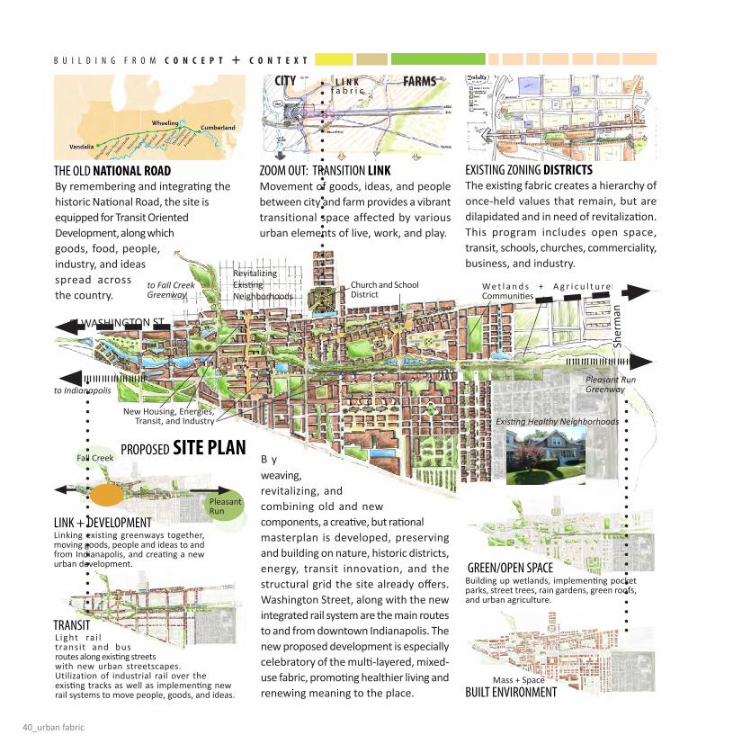
By remembering and integrating the historic National Road, the site is equipped for Transit Oriented Development, along which goods, food, people, industry, and ideas spread across the country.
B y weaving, revitalizing, and combining old and new components, a creative, but rational masterplan is developed, preserving and building on nature, historic districts, energy, transit innovation, and the structural grid the site already offers. Washington Street, along with the new integrated rail system are the main routes to and from downtown Indianapolis. The new proposed development is especially celebratory of the multi-layered, mixed-use fabric, promoting healthier living and renewing meaning to the place.
Movement of goods, ideas, and people between city and farm provides a vibrant transitional space affected by various urban elements of live, work, and play.
The existing fabric creates a hierarchy of once-held values that remain, but are dilapidated and in need of revitalization. This program includes open space, transit, schools, churches, commerciality, business, and industry.
ciTY l i n kf a b r i c
FarMS
tHe oLd naTiOnal rOaD
LInK + deveLoPMent
transIt
green/oPen sPaCe
buILt envIronMent
ZooM out: transItIon link eXIstIng ZonIng DiSTricTS
ProPosed SiTE Plan
E. WASHINGTON ST.
to Fall CreekGreenway
Church and School District
Building up wetlands, implementing pocket parks, street trees, rain gardens, green roofs, and urban agriculture.
Linking existing greenways together, moving goods, people and ideas to and from Indianapolis, and creating a new urban development.
L ight ra i l transit and bus routes along existing streets with new urban streetscapes. Utilization of industrial rail over the existing tracks as well as implementing new rail systems to move people, goods, and ideas.
New Housing, Energies, Transit, and Industry
Mass + Space
W e t l a n d s + A g r i c u l t u r e Communities
RevitalizingExisting Neighborhoods
Pleasant RunGreenway
Existing Healthy Neighborhoods
to Indianapolis
Sher
man
b u I L d I n g f r o M c O n c E P T + c O n T E x T

andrew m. hesterman_41
Residents participate in both self-sustaining, micro, and macro
economies, promoting human interaction, commerce,
and green energies.
The multi-layered personal experience of the development creates meaning and a sense of place, where residents thrive to live, work, and play.
The Development layers transit, urban civic centers, energy, agriculture, pedestrian humanistic interaction, an industrial extrapolation sequence, a commercial main street along Washington, a Park + Pocket Park System, and a healthy living and working environment frame, based on historical paradigm and potential. Density also forms a hierarchy to distinguish district and meaning of
I n t e g r a t I o n: liVE + WOrk + PlaY LIve+worK: rOOF GarDEnS
utILIZe EnVirOnMEnT
MuLtI TranSiT
LayeredMIXed-USE
green EnErGiES
Building up wetlands, implementing pocket parks, street trees, rain gardens, green roofs, natural energies, and urban agriculture.
Bus, light rail, bicycle, industrial rail, and pedestrian-only streets move goods, ideas, and people to, through and from Indianapolis and surrounding communities.
Wind, Geothermal Energy, Industrial Power for Heating, and new Green Energies, such as biofuel and algae, act as landmarks, civic venues, and functional components.
ProPosed DEVElOPMEnTIndustry Civic Open Com. Bus. Residential
42_urban fabric
CoLLaPse + asseMbLe streetsIde Cafe + vendIng
MobILe inDUSTrY
fLeXIbILIty + cOMMErcialiTY
ProMenade: PEDESTrian-OnlY STrEETS
utILIZIng tHe sHIPPIng ContaIner
MobILe Industry FlExibiliTY
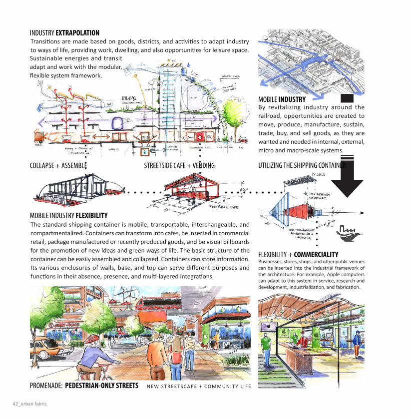
Industry ExTraPOlaTiOn
By revitalizing industry around the railroad, opportunities are created to move, produce, manufacture, sustain, trade, buy, and sell goods, as they are wanted and needed in internal, external, micro and macro-scale systems.
Transitions are made based on goods, districts, and activities to adapt industry to ways of life, providing work, dwelling, and also opportunities for leisure space. Sustainable energies and transit adapt and work with the modular, flexible system framework.
The standard shipping container is mobile, transportable, interchangeable, and compartmentalized. Containers can transform into cafes, be inserted in commercial retail, package manufactured or recently produced goods, and be visual billboards for the promotion of new ideas and green ways of life. The basic structure of the container can be easily assembled and collapsed. Containers can store information. Its various enclosures of walls, base, and top can serve different purposes and functions in their absence, presence, and multi-layered integrations.
N E W ST R E E TS C A P E + CO M M U N I T Y L I F E
Businesses, stores, shops, and other public venues can be inserted into the industrial framework of the architecture. For example, Apple computers can adapt to this system in service, research and development, industrialization, and fabrication.

andrew m. hesterman_43
CIrCuLatIon: GOODS + PEOPlE
wInterMETabOliSM
suMMerMETabOliSM
MIXedUSE
ProPosedarcHiTEcTUrEThe Architecture within the most dense area of the urban development focuses on a multidimensional, multiuse system, where industry is mobile and interactive, transit is centralized and directed, streets are vibrant, nature is harvested + cared for, and the public realm illuminates humanistic value. Citizens can work in the office, walk or take public transit home from work, go exercise at the YMCA, eat at a streetside cafe’ or restaurant, buy groceries, or walk to the park. All of these layers are integrated into moving toward a localized, intricately woven, sustainable way of life, thus finalizing, exhibiting and replicating the Urban Fabric concept on all levels of the Washington Street Corridor.
The public realm extends horizontally and vertically. These transitional spaces link to the East Washington Main Street, flowing into the transit hub and other zones. By layering circulation both vertically and horizontally, occupants can connect to industry, commerce, recreation, dwelling, transit, and business.
Ind. Transit Rec. Green. Com. Bus. Res.
new vs oLd STrEET
Underground Parking + Industrial Storage
PV Cells, Water Collection, Green Roofs, and Wind Power
Indoor/Outdoor Recreation Facilities
New Rail System
New Streetscape: Buffers, Rain
Gardens, Trolley, Traffic Calming
GreenWall + Residential
Balconies
The Living Line: Transforming The easT WashingTon Corridor
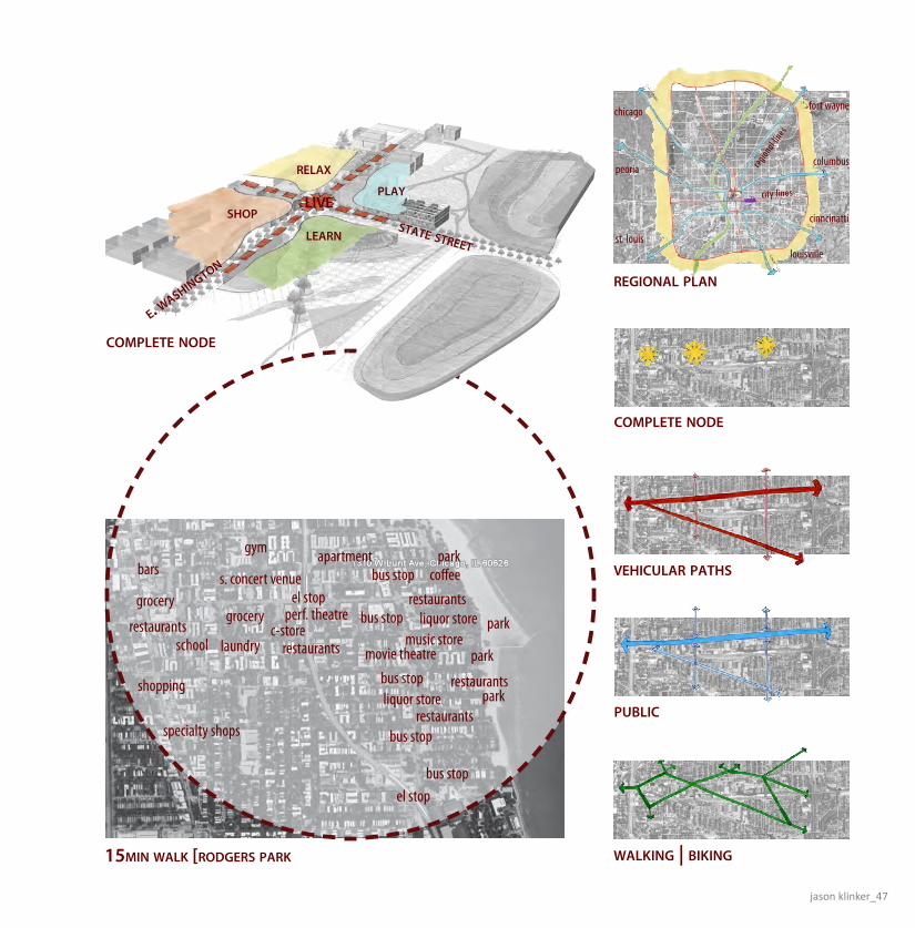
The Master Plan: The first step in designing a masterplan for the East Washington Corridor was to determine what components have provided successful urban settings in the past. For this I looked at the Rodger’s Park neighborhood on the northern most edges of Chicago. The two main observations I found were the successful use of a public transportation system and the socio-economic diversity formed by an adaptable urban form and a ranging program at various scales. I combined these with more modern ideas like a defined boarder limiting the horizontal growth of the city with food production around the perimeter.The public transportation is a standard 3-tier system with regional rails lines, city tram system, and an energy efficient bus system. The final layer was to add a system of green pathways to give distance/time advantage to those choosing to bike or walk from node to node or neigborhood to neighborhood.
The Complete Pod System: The idea is to create a diverse cross-section of homogenous communities that would than come together in sharing community spaces. This is done by providing each node all of the 15-min essentials for a self-sustaining community, but then linking them to the 45-min events that tie the community into the larger city scene. The neighborhoods are schematically created using ideas of form and juxtaposition of programmatic elements to respond to the themed areas, i.e. education, artistic, blue-collor. All these communities are seperate but can ‘visit’ one another due to easy transportation. The community identities will often shift as demographic and generational changes occur in neighborhoods. The key is that once an established neighborhood exist, it must be transformed slowly as changes happen - not in large scale developments that change the entire face of the community.
Recreation and Living: Developing an architectural moment in the changing community allows for a further investigation in both material characteristics and a representation of a general community belief system cohesive to modern ideas in much of the liberal art culture. Some of these ideals include the identification of phenomenology through material applications, humanitarian ideals celebrating equality through knowledge and self exploration, and environmental movements for healthy lifestyles and sustainable principles. The architecture that is demonstrated is a mixed-use facility with dwelling units above, recreational facilities below, and educational resources such as internet and computer access as well as books and other materials. Other key features include a shared community garden for the dwelling units, natural daylighting, passive heating and cooling systems, and the integration of the built and natural environments.
Jas
on
Kl
inK
er

jason klinker_45
state street

46_the living line
apartment
the loop
navy piermichigan ave millennium park
grant parkmuseum campus
united center
wrigley fieldthe gold coast
state street
soldier field
union station
midway airport
45 min public transportation
east washington master
sta
te st
reet
rura
l str
eet
e. washington
i-65
| i-7
0
southeastern ave.
jason klinker_47
apartment
el stopgrocery
laundry
parkbus stop coffee
restaurantsc-store
restaurantsliquor store
music store
restaurants
bars
grocery
restaurants
el stop
bus stop
bus stop
bus stop
bus stop
liquor storerestaurants
park
park
park
gym
school
shopping
specialty shops
perf. theatre
s. concert venue
movie theatre
15min walk [rodgers park
vehicular paths
public
walking | biking
complete node
region
al lin
es
city lines
chicago
peoria
st. louis
fort wayne
columbus
louisville
cinncinatti
regional plan
complete node
state street
e. washington
learn
shop
play
relax
live
48_the living line
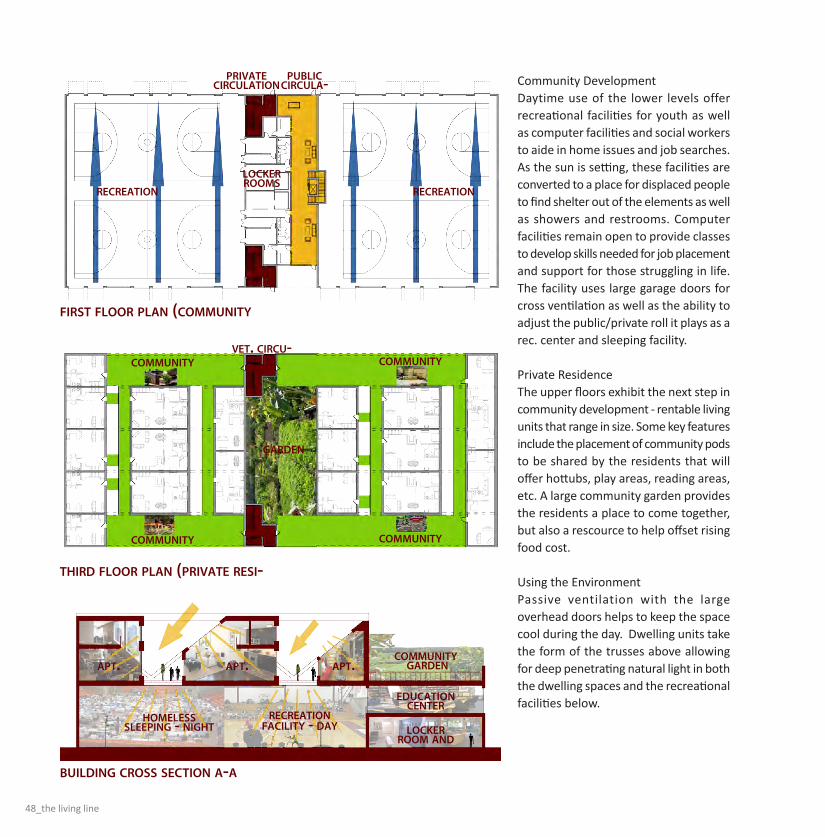
Community Development Daytime use of the lower levels offer recreational facilities for youth as well as computer facilities and social workers to aide in home issues and job searches. As the sun is setting, these facilities are converted to a place for displaced people to find shelter out of the elements as well as showers and restrooms. Computer facilities remain open to provide classes to develop skills needed for job placement and support for those struggling in life. The facility uses large garage doors for cross ventilation as well as the ability to adjust the public/private roll it plays as a rec. center and sleeping facility.
Private ResidenceThe upper floors exhibit the next step in community development - rentable living units that range in size. Some key features include the placement of community pods to be shared by the residents that will offer hottubs, play areas, reading areas, etc. A large community garden provides the residents a place to come together, but also a rescource to help offset rising food cost.
Using the EnvironmentPassive ventilation with the large overhead doors helps to keep the space cool during the day. Dwelling units take the form of the trusses above allowing for deep penetrating natural light in both the dwelling spaces and the recreational facilities below.
first floor plan (community
third floor plan (private resi-
building cross section a-a
homeless sleeping - night
recreationfacility - day
apt. apt. apt.community garden
educationcenter
locker room and
community
community
community
community
garden
vet. circu-
privatecirculation
public circula-
lockerrooms
recreationrecreation

jason klinker_49
state street
e. washington street
bike/walking paths
section perspective
state street node development

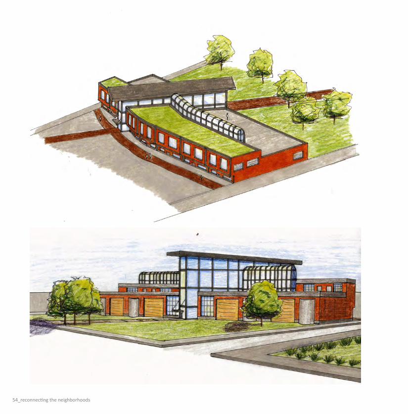
E WASHINGTON ST: RECONNECTING THE NEIGHBORHOODSWithin the 2 1/2 mile site there exist a multitude of issues which need to be addressed. These issues include deteriorating neighborhoods, abandoned brownfields, vacant and dilapidated buildings, lack of variety in uses, designed for the automobile, and difficulty or inability for one to access their daily needs in a convenient way. Taking these issues into consideration I created a design in which new nodes were created to spur new neighborhood growth centered around the five minute walk. Transit, green space, and a new pedestrian/bike trail were included to connect these new neighborhoods. Green methods were taken advantage of to create new, sustainable living, while preserving as much of the existing context and grid as possible. A portion of the overall design was chosen to further develop. Towards the west end of the site, nearest downtown, is the area I chose, a proposed arts and culture district. Buildings here were placed along the pedestrian/bike trail between either the existing railroad
tracks or the redesigned E Washington Street. Improvements to the street include a green median and other traffic calming methods. In the development sustainable methods were utilized to control and collect water, lower energy consumption, and enhance the quality of the spaces created. Buildings here were designed to cater to all one’s life needs, the live, work, play concept. This creates a complete and sustainable neighborhood that can be used as an example throughout the site. A building in the development area was chosen to design, for this piece a design center was chosen. The building utilizes the idea, as mentioned previously, of total living: live, work, play. It provides studio work space for artists to create their designs and products, retail space for shopping and dining, and apartments/lofts for
artists and other community members to reside in. The building also takes into account sustainable strategies like daylighting, water management, and passive heating and cooling systems. The lighting and passive heating and cooling are centered around the building’s main atria. This building could be used, like the development plan, as a precedent for other buildings awaiting to be designed in the neighborhood as well as any other buildings on the overall site. The building is located near transit and is directly adjacent to the pedestrian/bike trail. This allows for alternative means of transportation to be taken advantage of, essentially setting a new precedent for a new way of life that does not revolve around the convenience of the automobile.
KAT
E D
. LE
NG
ACH
ER

kate d. lengacher_51

52_reconnecting the neighborhoods
MASTER PLAN
This page illustrates the overall design. Three major pieces serve as connectors for the whole site. These are illustrated in the above diagrams: green space, pedestrian/bike trail, and water collection and control. The master plan at the top of the page shows all of the pieces that make the entire site a complete and sustainable network of revitalized neighborhoods.
Examples include localized water and energy plants, green industry, schools, commercial and residential mixed-use buildings, alternative energy collection, light rail transit, water collection and management, and urban agriculture.
Master Plan
Green Space Movement Water Collection
Concept

kate d. lengacher_53
DEVELOPMENT PLAN
This page highlights the arts and culture district. Above, the axon shows how buildings are organized along the new pedestrian path and redesigned E Washington Street. To the left are the design diagrams and plan. Below is the
new street section of E Washington that illustrates the use of a new green median, light rail transit, and parking lanes to create a new and aesthetically pleasing streetscape as well as a better functioning, multi-use, pedestrian friendly street.
Development Axon and Plan
Movement and Sustainability
E Washington Street
54_reconnecting the neighborhoods

kate d. lengacher_55
ARCHITECTURE
These pages highlight the architecture piece, the design center. To the left is the overall building axon portrays the front facade of the building showing where the building meets the pedestrian/bike trail as well as the atria that are the center of the sustainable features. These features are better illustrated in the first two diagrams to the right. They show the use of the sun’s light in heating the collected and stored water as well as heating and lighting the entire building. The atria also serve as passive ventilation chimneys for the building. The rear perspective to the left shows the rear elevation and how the cisterns are nestled into the walls as well as the use of garage doors to open up and connect or expand the interior studio spaces to the outdoor green space behind the building. The last diagram at the bottom of this pages shows the flow of products. Starting from left of the red arrow: raw materials in to fabrication and production. With the purple arrow: fabricated products to the store as merchandise. The blue arrow: in store merchandise sold into the homes of people in the community. The plan diagram at the top shows the general layout of the building. To the north are the retail spaces along the trail with residential units above. To the south are the live/work studios that spill out into the rear green space
Plan Cistern Diagram
Daylighting and Ventilation Diagram
Production Flow Diagram

InfIltratIng East WashIngton strEEt: Stitching together the Urban Fabric
The essential problem with the site on East Washington Street is the lack of community and connectivity between the people and the buildings. As a result of or even the direct cause of sprawl, people seem to want nothing more than to never have to encounter another human being other than perhaps their immediate family, and of course for a limited time at that and only if the TV is on. The design I am proposing of course can only aim to cure the lack of communication between buildings, but hopefully have some positive affect on the inhabitants in the process.
One of the first decisions made in this process was to take the traditional tunnel road of Washington Street and curve and bend it around its original axis to help break up the monotony and division inherent within the five traffic lane, three foot sidewalk system found on site. This new system would help alleviate the tunnel vision created by the old system because the drivers
and passengers field of view would be filled with frequently changing urban landscapes at such a scale as to provide a comfortable feeling of spatial enclosure.
The traffic would also be slowed down with other various methods of traffic calming that would hopefully not interfere too heavily with flow, but would ultimately make the
pedestrian much more comfortable and feel more secure. The road in this design is not supposed to disappear, instead it will just move down in its importance to fit in and work with the rest of the elements that make a successful space. The car is not inherently evil, it serves the most needed purpose in our modern society of transporting all of our lazy selves to and from our destinations.
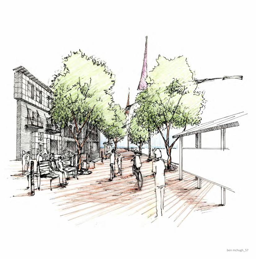
The big idea is to make smaller and more concentrated areas of activity to serve as one of those destinations that we are willing or excited to drive to, park and explore. The space should be interesting enough that walking is basically necessary if you want to see and experience all of the fun details that cannot be understood while driving by at thirty miles per hour. There must be layers of activity and of positive and negative space so that people can fill in and take possession.
be
n M
ch
Ug
h
ben mchugh_57

58_infiltrating east washington street
The master plan above shows Washington Street curving through the proposed additions of commercial and mixed use buildings (in red and orange). The car itself has somewhat limited access to buildings as parking is now located entirely either behind or underneath businesses. Once a person has stepped out of their car or off the bus (or other mass transit system: the light rail seen
in the drawing below), they are then exposed to the full experience of this urban environment. As you are walking around the different areas, your choices for traveling are quite diverse. You could walk along the streets, in the alleyways between the buildings, or even along the creek, which provides a very scenic boardwalk.
ben mchugh_59
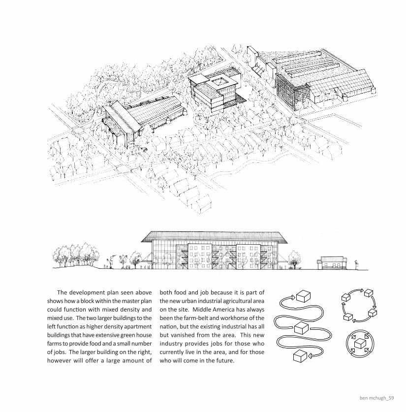
The development plan seen above shows how a block within the master plan could function with mixed density and mixed use. The two larger buildings to the left function as higher density apartment buildings that have extensive green house farms to provide food and a small number of jobs. The larger building on the right, however will offer a large amount of
both food and job because it is part of the new urban industrial agricultural area on the site. Middle America has always been the farm-belt and workhorse of the nation, but the existing industrial has all but vanished from the area. This new industry provides jobs for those who currently live in the area, and for those who will come in the future.

60_infiltrating east washington street
Current process of farming, production and distribution.
Proposed process of farming, production and distribution.
Proposed site specific distribution diagram.

ben mchugh_61
The apartment building featured on this page is the one seen on the development plan drawing two pages back (it is the large one on the far left). Its garden space run east to west and shares the balcony space with the adjacent apartments on the first and third floors. The greenhouse, besides providing food, also helps regulate the air quality of the main atrium (and the apartments if you leave the door open). The atrium space serves as circulation and leisure space as it is wide enough to accommodate several picnicking families, perhaps a casual game of frisbee, or just provide a warm, outdoor atmosphere in the winter months. Finally, the butterfly roof down the middle serves to let daylight in and also funnel rainwater down into collection
Greenbelt Gateway: A TemplATe for New GrowTh
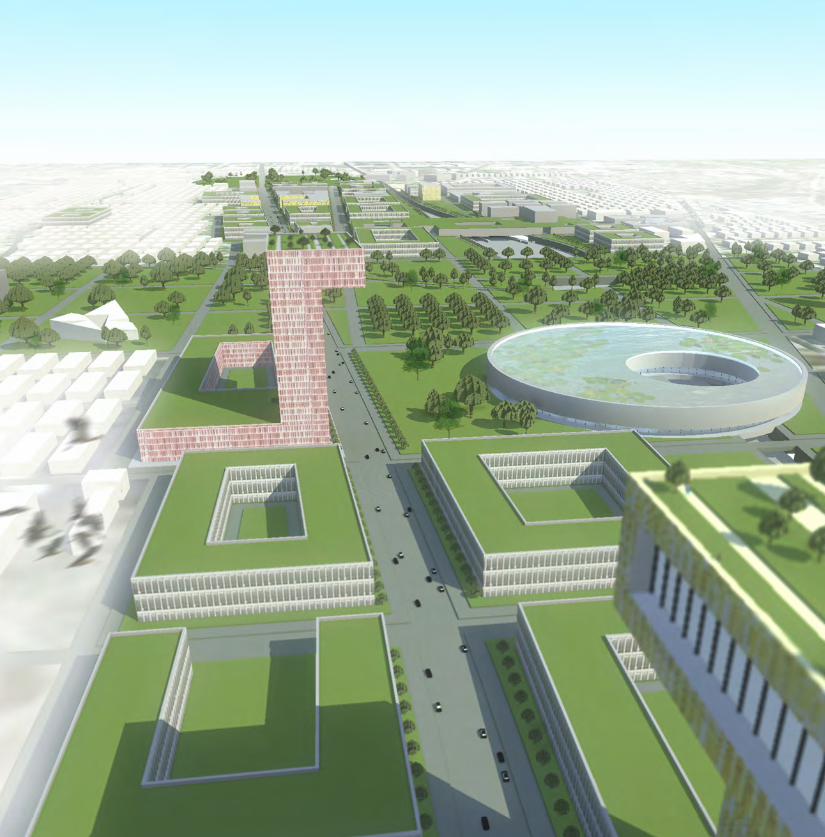
The Greenbelt Gateway is proposed along East Washington Street in Indianapolis, Indiana. This roadway, U.S. 40, used to be a major national east/west passage for cross country travel and transferring of goods. The current state of the site contains: zoning disintegration, grey areas, north/south segregation, and pass through areas. Once a flourishing area of town, East Washington Street decreased in safety and quality of life as many industrial plants moved out of the area. The Greenbelt Gateway proposes to re-connect these neighborhoods and create a template for growth in regards to public transportation, density, andzoning specifications. The proposed development incorporates a 4 main design concepts: sinking the railway below ground level, re-routing the river, developing two major parks, and bridging over the railway. The railway is proposed below ground level to allow for unobstructed circulation between the north and the south sides of the site. This organization
is based on the concept of vertical layering. The nearby river is re-routed onto the site to create more rainwater overflow areas on the site. The excess soil from digging the railway and river is used to create two city-wide parks on the site. The cultural park bridges over the railway and the circular park aligns with the monument circle downtown, approximately 4 miles away. As the railway is a major resource for importing and exporting, a series of industrial buildings bridge to allow for efficient access to the railcars below. The Greenbelt Gateway, as earlier stated, acts as a template for future growth in Indianapolis. The growth is mainly a response to the incorporation of a light-rail public transportation system following the city’s central urban layout. The future growth illustrates the transition from suburban sprawl to efficient urban growth. This light-rail transportation system creates a guideline for growth, allowing commuters to efficiently get to the city’s center with the use of public transportation. The
proposed development incorporates a number of environmental elements, aiming at creating an ecologically sensitive area. Approximately 85% of the buildings in the new development incorporate green roof systems. These green roofs minimize on-site water runoff as well as create a cleaner environment. Geothermal technology is incorporated into a number of the major developments to efficiently utilize the site’s natural resources. Additionally, solar panel systems are placed throughout the development to power the surrounding buildings.
Ad
Am
d.
mil
le
r
adam d. miller_63

64_greenbelt gateway
Asterix Concept:Indianapolis’ city layout allows for a central light rail system. The future growthfollows the pattern of an asterix. The spatial organization allows for agriculturalareas between the transportation lines.
MAIN LEVEL FLOOR PLAN:NOT TO SCALE
ROOF LEVEL FLOOR PLAN:NOT TO SCALE
OPEN COURTYARDVENTILATION
THROUGHOUTTHE BUILDING
OPEN CIRCULATIONPATHS
FOR EFFICIENT HEATINGAND COOLING
SOLAR ENERGYFOR INDUSTRIAL
TECHNOLOGYAND SURROUNDING
BLDGS
GEOTHERMAL ENERGYTECHNOLOGY
MIXED USE /COMMERCIAL ZONE
INDUSTRIAL /PRODUCTION
ZONE
RAILWAY ZONEBELOW GROUND
COMMERCIALZONE
COMMERCIAL TOWERZONE
VERTICAL ACCESS OFRAILWAY SYSTEM FOR
IMPORTING /EXPORTING
GOODS
EXPORTED GOODSSOLD
IN MARKET ANDCOMMERCIAL
ZONES
MANUFACTURINGOFFICES
INCORPORATING:DESIGN,
PRODUCTDEVELOPMENT, ETC.
TRUCK IMPORTING /EXPORTING
TRUCK IMPORTING /EXPORTING
RAILWAY IMPORTING/ EXPORTING
ENVIRONMENTAL SYSTEMS:SUSTAINABLE TECHNOLOGIES CREATING AN ENERGYEFFICIENT PRODUCTION FACILITY
PROGRAMMATIC ZONING:MIXED USE ZONING AIMING AT CREATING AN OVERLAPPINGOF ZONES AND USES
IMPORTING / EXPORTING:IMPORTING AND EXPORTING LOCAL GOODS BYWAY OF RAIL, TRUCKS, AND COMMERCIAL ZONING
COMMERCIAL / OFFICE
MIXED USE
INDUSTRIAL / PRODUCTION
RAILWAY SYSTEM
MARKET TYPOLOGY:AN EMPHASIS ON LOCAL GOODS SUCH ASPRODUCE AND PRODUCTS. LA RAMBLA IS AMARKET IN DOWNTOWN BARCELONA WITHA VIBRANT ATMOSPHERE.
FACTORY BUILDING:THE LARGE SCALE PROVIDES ITEMS FORMASS PRODUCTION THROUGH EFFICIENCY INCOST. THE PRODUCTION ALLOWS FOR LOCALAND GLOBAL EXPORTING OF GOODS.
ASTERIX CONCEPT:
FIVE-FINGER GROWTH: COPENHAGEN, DENMARK
Copenhagen's public transportation system is in the form of five fingers.This spatial organization allows for density along the transportation routeswith agricultural areas between the fingers.
ASTERIX GROWTH: INDIANAPOLIS, INDIANA
Indianapolis' city layout allows for a central light rail system. The future growthfollows the pattern of an asterix. The growth pattern allows for agriculturalareas between the transportation lines. The asterix shape emphasizes equality on all sides, making the south side just as important as the north side.
To Shelbyville
To Lebanon To Fishers
The eastern line will run along East Washington Street, giving suburbancommuters an efficient way to get to the city.
DENSITY GROWTH:
INCORPORATING TOWERS:
The proposed light-rail system provides a guideline for future growth in the city area. East Washington,being directly on axis with the transportation can emphasize this density by incorporating medium-sizedtowers.
INCREASING DENSITY/SCALE
HighDensity
Med.Density
LowDensity
Density growth alonglight-rail transportation
system
REACTIVE ZONING:
EAST WASHINGTON STREET:
As a response to the disconnection of the north and south side of Washington Street, a strategy ofREACTIVE ZONING is incorporated into the design. Reactive
CourtyardReactiveForms
ReactiveProgramming
ReactivePathways
FRAMING THE SKYLINE:
ENTRY TO THE CITY:
Large buildings along Washington Street help frame Indianapolis' skyline as one enters the city. Theseelements emphasize the concept of a gateway to the city.
DowntownSkyline
NorthBuilding
SouthBuilding
Conceptual Perspective of Washington Street Looking West
A CITY OF CIRCLES:Indianapolis is well-known for its circular citycenter. What happens if the circle is copiedthroughout the city varying in SCALE,FORM, and PROGRAM?
Monument Circle:A circular void creating
a significant node inthe city
Water Circle:A recreational or ecologicalelement incorporating water
in an urban environment
Circle Building:A large scale circular building
acting as a center forsurrounding neighborhoods
Green Circle:A vegetative park creatingopen space in an urban
environment
Circle Courtyard:A large scale courtyard
building acts as a center forsurrounding neighborhoods
NORTH / SOUTH SEGREGATION GREY AREAS NEAR RAILWAY
ZONING DISINTEGRATION PASS-THROUGH AREA
MEDIUM DENSITY COURTYARD HOUSING:
The proposed courtyard housing emphasizes density in urban living with the use of shared green spaceand small setbacks. This is a response to the existing single family housing conditions on the site thatare more applicable for suburban areas.
The altering organization allows for diversity in courtyard shapes and sizes. The buildings incorporatesustainable systems such as:
- VEGETATIVE ROOF
- ON-SITE WATER RETENTION
- GEOTHERMAL TECHNOLOGY
- SOLAR ENERGY
BUILDING SECTION A-A:Not To Scale
GREENBELT GATEWAY: A TEMPLATE FORURBAN GROWTHEAST WASHINGTON STREET INDIANAPOLIS, IN
The Greenbelt Gateway is proposed along East Washington Street in Indianapolis, Indiana. This roadway, U.S. 40, used to be a major national east/west passage for cross country travel and transferring of goods.The current state of the site contains: zoning disintegration, grey areas, north/south segregation, and pass through areas. Once a flourishing area of town, East Washington Street decreased in safety and qualityof life as many industrial plants moved out of the area. The Greenbelt Gateway proposes to re-connect these neighborhoods and create a template for growth in regards to public transportation, density, andzoning specifications.
The proposed development incorporates a 4 main design concepts: sinking the railway below ground level, re-routing the river, developing two major parks, and bridging over the railway. The railway is proposedbelow ground level to allow for unobstructed circulation between the north and the south sides of the site. This organization is based on the concept of vertical layering. The nearby river is re-routed onto the siteto create more rainwater overflow areas on the site. The excess soil from digging the railway and river is used to create two city-wide parks on the site. The cultural park bridges over the railway and the circularpark aligns with the monument circle downtown, approximately 4 miles away. As the railway is a major resource for importing and exporting, a series of industrial buildings bridge over the railway to allow forefficient access to the railcars below.
Green Zones:
Elements:Cultural Park, Circle Park, courtyards, vegetativeroofs, and greenways
Description:The master plan incorporates 3 major elements ofGreen Zones: major park space, courtyards, andrecreational greenways. The 2 major parks areconnected by east/west greenways along the sunkenrailway and East Washington Street. The Greenzone decreases water run-off in the area and createsa more ecologically driven micro climate.
Building Program:
Elements:
Cultural
Mixed-Use
Residential
Industrial
Ecological
Description:The existing site maintains a segregation of zones,specifically industrial, residential, and commercial.This segregation creates cultural and physicalbarriers on the site. The proposed developmentaims at overlapping and layering new zones as away of decreasing those barriers. The standardbuilding typology is based on the interior courtyard,allowing for efficient natural light and green space.
Circulation:
Elements:
Highway
Light-Rail Transit
Railway
High-use Roadway
Low-use Roadway
Description:The proposed development lowers the existingrailway below ground level to allow for unobstructedcirculation perpendicular to the railway. Theproposed light-rail system is located along EastWashington Street, connecting the city center withthe surrounding suburbs.
Existing Context:
Elements:
Residential, Industrial, and Commercial Buildings
Description:The surrounding buildings create spatial guidelinesfor the proposed masterplan. The scale of theexisting buildings illustrate a rural scale, that willeventually shift following the proposed development.
FIRST LEVEL FLOOR PLAN :Not To Scale
This housing type is one of (3) incorporated into the masterplan. High density courtyard housing as wellas high density residential towers are added to dense areas of proposed plan. Each typologyincorporates the courtyard concept, emphasizing natural daylighting and vegetation.
ROOF LEVEL FLOOR PLAN:Not To Scale
The roof level incorporates an extensive vegetative green roof as well as a roof pond for retainingrainwater. The roof level is also used for local agriculture.
PRODUCTION PLANT BUILDING:
The central production plant bridges across the sunken railway system. This situation allows for efficientimporting and exporting of goods by rail and trucks. The building incorporates 2 typologies: the factoryand the market. The building looks at the local area as its consumers, incorporating a large farmersmarket within the building. The roof creates a controlled public park and also growing surfaces for localagriculture.
The Greenbelt Gateway, as earlier stated, acts as a template for future growth in Indianapolis. The growth is mainly a response to the incorporation of a light-rail public transportation system following the city'scentral urban layout. The future growth illustrates the transition from suburban sprawl to efficient urban growth. This light-rail transportation system creates a guideline for growth, allowing commuters to efficientlyget to the city's center with the use of public transportation.
The proposed development incorporates a number of environmental elements, aiming at creating an ecologically sensitive area. Approximately 85% of the buildings in the new development incorporate green roofsystems. These green roofs minimize on-site water runoff as well as create a cleaner environment. Geothermal technology is incorporated into a number of the major developments to efficiently utilize the site'snatural resources. Additionally, solar panel systems are placed throughout the development to power the surrounding buildings.
OPEN TOBELOW
MARKET
TOWERPLAZA
VEGETATIVE/SOLAR ROOF
W/ PUBLICACCESS
MARKET
MIXED-USE
MIXED-USE
MIXED-USE
RESIDENTIAL
COMMUNITYBLDG
GREEN ROOF/ROOF POND
Phase One:
Description:The first phase of the development incorporates the major elements of the urban design. Theseinclude: the sunken railway, the light-rail, the 2 major parks, mixed-use and commercialbuildings. The excavated soil from the sunken rail is used to create topography for the twoparks.
Phase Two:
Description:Following the commercial development in Phase One, the residential development is addedalong East Washington Street. Additionally, the major industrial buildings are added along thesunken railway. Phase Two of the parks includes further development.
Phase Three:
Description:Phase Three illustrates the concept of efficient density growth. This density includes the tworesidential towers and further growth along East Washington Street and the sunken railway.
Sunken Rail System
Light-Rail System
Mixed-use Development
Commercial Development
Preliminary Park Development
Industrial / Bridging Development
Continued Park Development
Re-route River onto Site
Residential Towers
Cultural Buildings
Efficient Density Growth
AXON DIAGRAM:Not To Scale
Sun Path
MarketCirculation
Market
Parking Parking
Green Roof
Green Roof
EXISTING CONDITIONS:SITE CONTEXT:
U.S. HIGHWAY 40SITE
EASTBOUND TOWARDBALTIMORE, MD
WESTBOUND TOWARDLOS ANGELES, CA
The site is situated approximately 3 miles east ofmonument circle in downtown Indianapolis. TheGreenbelt Gateway development is between InterstateI-70 and Sherman Street.
WASHINGTON STREET PERSPECTIVE:Framed View Toward Downtown Skyline
ROOFTOP PERSPECTIVE:Production Plant Building
MARKET AREA PERSPECTIVE:Production Plant Building
AERIAL PERSPECTIVE:Greenbelt Gateway Looking East
MONUMENT CIRCLEINDIANAPOLIS, IN
LARGE AMOUNTS OFSUBURBAN GROWTH HAS
OCCURRED ON THENORTH SIDE OF THE CITY
HIGH DENSITY OCCURSALONG INDIANAPOLIS'
HIGHWAY SYSTEM
Density Growth:The proposed light-rail system provides a guideline for future growth in the city area. East Washington, being directly on axis with the transportation can emphasize this density by incorporating medium-sized towers.
Reactive Zoning:As a response to the disconnection of the north and south side of Washington Street, a strategy of reactive zoning is incorporated into the design.
Framed View:Large buildings along Washington Street help frame Indianapolis’ skyline as one enters the city. These elements emphasize the concept of a gateway to the city.
City of Circles:Indianapolis is well-known for its circular city center. What happens if the circle is copied throughout the city varying in scale, form, and program?

adam d. miller_65
The proposed masterplan is developed in three project phases. This allows for gradual and organized growth for a large-scale development. The first phase of the development incorporates the major elements of the urban design. These include: the sunken railway, the light-rail, the 2 major parks, mixed-use and commercial buildings.
MAIN LEVEL FLOOR PLAN:NOT TO SCALE
ROOF LEVEL FLOOR PLAN:NOT TO SCALE
OPEN COURTYARDVENTILATION
THROUGHOUTTHE BUILDING
OPEN CIRCULATIONPATHS
FOR EFFICIENT HEATINGAND COOLING
SOLAR ENERGYFOR INDUSTRIAL
TECHNOLOGYAND SURROUNDING
BLDGS
GEOTHERMAL ENERGYTECHNOLOGY
MIXED USE /COMMERCIAL ZONE
INDUSTRIAL /PRODUCTION
ZONE
RAILWAY ZONEBELOW GROUND
COMMERCIALZONE
COMMERCIAL TOWERZONE
VERTICAL ACCESS OFRAILWAY SYSTEM FOR
IMPORTING /EXPORTING
GOODS
EXPORTED GOODSSOLD
IN MARKET ANDCOMMERCIAL
ZONES
MANUFACTURINGOFFICES
INCORPORATING:DESIGN,
PRODUCTDEVELOPMENT, ETC.
TRUCK IMPORTING /EXPORTING
TRUCK IMPORTING /EXPORTING
RAILWAY IMPORTING/ EXPORTING
ENVIRONMENTAL SYSTEMS:SUSTAINABLE TECHNOLOGIES CREATING AN ENERGYEFFICIENT PRODUCTION FACILITY
PROGRAMMATIC ZONING:MIXED USE ZONING AIMING AT CREATING AN OVERLAPPINGOF ZONES AND USES
IMPORTING / EXPORTING:IMPORTING AND EXPORTING LOCAL GOODS BYWAY OF RAIL, TRUCKS, AND COMMERCIAL ZONING
COMMERCIAL / OFFICE
MIXED USE
INDUSTRIAL / PRODUCTION
RAILWAY SYSTEM
MARKET TYPOLOGY:AN EMPHASIS ON LOCAL GOODS SUCH ASPRODUCE AND PRODUCTS. LA RAMBLA IS AMARKET IN DOWNTOWN BARCELONA WITHA VIBRANT ATMOSPHERE.
FACTORY BUILDING:THE LARGE SCALE PROVIDES ITEMS FORMASS PRODUCTION THROUGH EFFICIENCY INCOST. THE PRODUCTION ALLOWS FOR LOCALAND GLOBAL EXPORTING OF GOODS.
ASTERIX CONCEPT:
FIVE-FINGER GROWTH: COPENHAGEN, DENMARK
Copenhagen's public transportation system is in the form of five fingers.This spatial organization allows for density along the transportation routeswith agricultural areas between the fingers.
ASTERIX GROWTH: INDIANAPOLIS, INDIANA
Indianapolis' city layout allows for a central light rail system. The future growthfollows the pattern of an asterix. The growth pattern allows for agriculturalareas between the transportation lines. The asterix shape emphasizes equality on all sides, making the south side just as important as the north side.
To Shelbyville
To Lebanon To Fishers
The eastern line will run along East Washington Street, giving suburbancommuters an efficient way to get to the city.
DENSITY GROWTH:
INCORPORATING TOWERS:
The proposed light-rail system provides a guideline for future growth in the city area. East Washington,being directly on axis with the transportation can emphasize this density by incorporating medium-sizedtowers.
INCREASING DENSITY/SCALE
HighDensity
Med.Density
LowDensity
Density growth alonglight-rail transportation
system
REACTIVE ZONING:
EAST WASHINGTON STREET:
As a response to the disconnection of the north and south side of Washington Street, a strategy ofREACTIVE ZONING is incorporated into the design. Reactive
CourtyardReactiveForms
ReactiveProgramming
ReactivePathways
FRAMING THE SKYLINE:
ENTRY TO THE CITY:
Large buildings along Washington Street help frame Indianapolis' skyline as one enters the city. Theseelements emphasize the concept of a gateway to the city.
DowntownSkyline
NorthBuilding
SouthBuilding
Conceptual Perspective of Washington Street Looking West
A CITY OF CIRCLES:Indianapolis is well-known for its circular citycenter. What happens if the circle is copiedthroughout the city varying in SCALE,FORM, and PROGRAM?
Monument Circle:A circular void creating
a significant node inthe city
Water Circle:A recreational or ecologicalelement incorporating water
in an urban environment
Circle Building:A large scale circular building
acting as a center forsurrounding neighborhoods
Green Circle:A vegetative park creatingopen space in an urban
environment
Circle Courtyard:A large scale courtyard
building acts as a center forsurrounding neighborhoods
NORTH / SOUTH SEGREGATION GREY AREAS NEAR RAILWAY
ZONING DISINTEGRATION PASS-THROUGH AREA
MEDIUM DENSITY COURTYARD HOUSING:
The proposed courtyard housing emphasizes density in urban living with the use of shared green spaceand small setbacks. This is a response to the existing single family housing conditions on the site thatare more applicable for suburban areas.
The altering organization allows for diversity in courtyard shapes and sizes. The buildings incorporatesustainable systems such as:
- VEGETATIVE ROOF
- ON-SITE WATER RETENTION
- GEOTHERMAL TECHNOLOGY
- SOLAR ENERGY
BUILDING SECTION A-A:Not To Scale
GREENBELT GATEWAY: A TEMPLATE FORURBAN GROWTHEAST WASHINGTON STREET INDIANAPOLIS, IN
The Greenbelt Gateway is proposed along East Washington Street in Indianapolis, Indiana. This roadway, U.S. 40, used to be a major national east/west passage for cross country travel and transferring of goods.The current state of the site contains: zoning disintegration, grey areas, north/south segregation, and pass through areas. Once a flourishing area of town, East Washington Street decreased in safety and qualityof life as many industrial plants moved out of the area. The Greenbelt Gateway proposes to re-connect these neighborhoods and create a template for growth in regards to public transportation, density, andzoning specifications.
The proposed development incorporates a 4 main design concepts: sinking the railway below ground level, re-routing the river, developing two major parks, and bridging over the railway. The railway is proposedbelow ground level to allow for unobstructed circulation between the north and the south sides of the site. This organization is based on the concept of vertical layering. The nearby river is re-routed onto the siteto create more rainwater overflow areas on the site. The excess soil from digging the railway and river is used to create two city-wide parks on the site. The cultural park bridges over the railway and the circularpark aligns with the monument circle downtown, approximately 4 miles away. As the railway is a major resource for importing and exporting, a series of industrial buildings bridge over the railway to allow forefficient access to the railcars below.
Green Zones:
Elements:Cultural Park, Circle Park, courtyards, vegetativeroofs, and greenways
Description:The master plan incorporates 3 major elements ofGreen Zones: major park space, courtyards, andrecreational greenways. The 2 major parks areconnected by east/west greenways along the sunkenrailway and East Washington Street. The Greenzone decreases water run-off in the area and createsa more ecologically driven micro climate.
Building Program:
Elements:
Cultural
Mixed-Use
Residential
Industrial
Ecological
Description:The existing site maintains a segregation of zones,specifically industrial, residential, and commercial.This segregation creates cultural and physicalbarriers on the site. The proposed developmentaims at overlapping and layering new zones as away of decreasing those barriers. The standardbuilding typology is based on the interior courtyard,allowing for efficient natural light and green space.
Circulation:
Elements:
Highway
Light-Rail Transit
Railway
High-use Roadway
Low-use Roadway
Description:The proposed development lowers the existingrailway below ground level to allow for unobstructedcirculation perpendicular to the railway. Theproposed light-rail system is located along EastWashington Street, connecting the city center withthe surrounding suburbs.
Existing Context:
Elements:
Residential, Industrial, and Commercial Buildings
Description:The surrounding buildings create spatial guidelinesfor the proposed masterplan. The scale of theexisting buildings illustrate a rural scale, that willeventually shift following the proposed development.
FIRST LEVEL FLOOR PLAN :Not To Scale
This housing type is one of (3) incorporated into the masterplan. High density courtyard housing as wellas high density residential towers are added to dense areas of proposed plan. Each typologyincorporates the courtyard concept, emphasizing natural daylighting and vegetation.
ROOF LEVEL FLOOR PLAN:Not To Scale
The roof level incorporates an extensive vegetative green roof as well as a roof pond for retainingrainwater. The roof level is also used for local agriculture.
PRODUCTION PLANT BUILDING:
The central production plant bridges across the sunken railway system. This situation allows for efficientimporting and exporting of goods by rail and trucks. The building incorporates 2 typologies: the factoryand the market. The building looks at the local area as its consumers, incorporating a large farmersmarket within the building. The roof creates a controlled public park and also growing surfaces for localagriculture.
The Greenbelt Gateway, as earlier stated, acts as a template for future growth in Indianapolis. The growth is mainly a response to the incorporation of a light-rail public transportation system following the city'scentral urban layout. The future growth illustrates the transition from suburban sprawl to efficient urban growth. This light-rail transportation system creates a guideline for growth, allowing commuters to efficientlyget to the city's center with the use of public transportation.
The proposed development incorporates a number of environmental elements, aiming at creating an ecologically sensitive area. Approximately 85% of the buildings in the new development incorporate green roofsystems. These green roofs minimize on-site water runoff as well as create a cleaner environment. Geothermal technology is incorporated into a number of the major developments to efficiently utilize the site'snatural resources. Additionally, solar panel systems are placed throughout the development to power the surrounding buildings.
OPEN TOBELOW
MARKET
TOWERPLAZA
VEGETATIVE/SOLAR ROOF
W/ PUBLICACCESS
MARKET
MIXED-USE
MIXED-USE
MIXED-USE
RESIDENTIAL
COMMUNITYBLDG
GREEN ROOF/ROOF POND
Phase One:
Description:The first phase of the development incorporates the major elements of the urban design. Theseinclude: the sunken railway, the light-rail, the 2 major parks, mixed-use and commercialbuildings. The excavated soil from the sunken rail is used to create topography for the twoparks.
Phase Two:
Description:Following the commercial development in Phase One, the residential development is addedalong East Washington Street. Additionally, the major industrial buildings are added along thesunken railway. Phase Two of the parks includes further development.
Phase Three:
Description:Phase Three illustrates the concept of efficient density growth. This density includes the tworesidential towers and further growth along East Washington Street and the sunken railway.
Sunken Rail System
Light-Rail System
Mixed-use Development
Commercial Development
Preliminary Park Development
Industrial / Bridging Development
Continued Park Development
Re-route River onto Site
Residential Towers
Cultural Buildings
Efficient Density Growth
AXON DIAGRAM:Not To Scale
Sun Path
MarketCirculation
Market
Parking Parking
Green Roof
Green Roof
EXISTING CONDITIONS:SITE CONTEXT:
U.S. HIGHWAY 40SITE
EASTBOUND TOWARDBALTIMORE, MD
WESTBOUND TOWARDLOS ANGELES, CA
The site is situated approximately 3 miles east ofmonument circle in downtown Indianapolis. TheGreenbelt Gateway development is between InterstateI-70 and Sherman Street.
WASHINGTON STREET PERSPECTIVE:Framed View Toward Downtown Skyline
ROOFTOP PERSPECTIVE:Production Plant Building
MARKET AREA PERSPECTIVE:Production Plant Building
AERIAL PERSPECTIVE:Greenbelt Gateway Looking East
MONUMENT CIRCLEINDIANAPOLIS, IN
LARGE AMOUNTS OFSUBURBAN GROWTH HAS
OCCURRED ON THENORTH SIDE OF THE CITY
HIGH DENSITY OCCURSALONG INDIANAPOLIS'
HIGHWAY SYSTEM
Project Phases:
Masterplan:
Streetview Perspective:
The excavated soil from the sunken rail is used to create topography for the two parks. Following the commercial development in Phase One, the residential development is added along East Washington Street. Additionally, the major industrial buildings are added along the sunken railway. Phase Two of the park areas include further
development. Phase Three illustrates the concept of efficient density growth. This density includes the two residential towers and further growth along East Washington Street and the sunken railway.
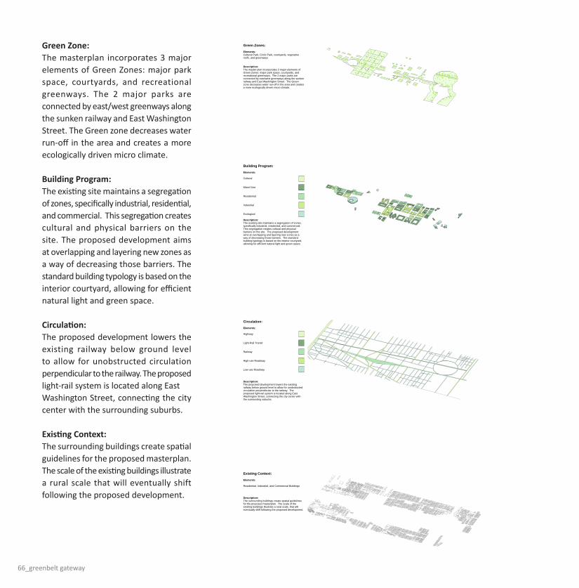
66_greenbelt gateway
MAIN LEVEL FLOOR PLAN:NOT TO SCALE
ROOF LEVEL FLOOR PLAN:NOT TO SCALE
OPEN COURTYARDVENTILATION
THROUGHOUTTHE BUILDING
OPEN CIRCULATIONPATHS
FOR EFFICIENT HEATINGAND COOLING
SOLAR ENERGYFOR INDUSTRIAL
TECHNOLOGYAND SURROUNDING
BLDGS
GEOTHERMAL ENERGYTECHNOLOGY
MIXED USE /COMMERCIAL ZONE
INDUSTRIAL /PRODUCTION
ZONE
RAILWAY ZONEBELOW GROUND
COMMERCIALZONE
COMMERCIAL TOWERZONE
VERTICAL ACCESS OFRAILWAY SYSTEM FOR
IMPORTING /EXPORTING
GOODS
EXPORTED GOODSSOLD
IN MARKET ANDCOMMERCIAL
ZONES
MANUFACTURINGOFFICES
INCORPORATING:DESIGN,
PRODUCTDEVELOPMENT, ETC.
TRUCK IMPORTING /EXPORTING
TRUCK IMPORTING /EXPORTING
RAILWAY IMPORTING/ EXPORTING
ENVIRONMENTAL SYSTEMS:SUSTAINABLE TECHNOLOGIES CREATING AN ENERGYEFFICIENT PRODUCTION FACILITY
PROGRAMMATIC ZONING:MIXED USE ZONING AIMING AT CREATING AN OVERLAPPINGOF ZONES AND USES
IMPORTING / EXPORTING:IMPORTING AND EXPORTING LOCAL GOODS BYWAY OF RAIL, TRUCKS, AND COMMERCIAL ZONING
COMMERCIAL / OFFICE
MIXED USE
INDUSTRIAL / PRODUCTION
RAILWAY SYSTEM
MARKET TYPOLOGY:AN EMPHASIS ON LOCAL GOODS SUCH ASPRODUCE AND PRODUCTS. LA RAMBLA IS AMARKET IN DOWNTOWN BARCELONA WITHA VIBRANT ATMOSPHERE.
FACTORY BUILDING:THE LARGE SCALE PROVIDES ITEMS FORMASS PRODUCTION THROUGH EFFICIENCY INCOST. THE PRODUCTION ALLOWS FOR LOCALAND GLOBAL EXPORTING OF GOODS.
ASTERIX CONCEPT:
FIVE-FINGER GROWTH: COPENHAGEN, DENMARK
Copenhagen's public transportation system is in the form of five fingers.This spatial organization allows for density along the transportation routeswith agricultural areas between the fingers.
ASTERIX GROWTH: INDIANAPOLIS, INDIANA
Indianapolis' city layout allows for a central light rail system. The future growthfollows the pattern of an asterix. The growth pattern allows for agriculturalareas between the transportation lines. The asterix shape emphasizes equality on all sides, making the south side just as important as the north side.
To Shelbyville
To Lebanon To Fishers
The eastern line will run along East Washington Street, giving suburbancommuters an efficient way to get to the city.
DENSITY GROWTH:
INCORPORATING TOWERS:
The proposed light-rail system provides a guideline for future growth in the city area. East Washington,being directly on axis with the transportation can emphasize this density by incorporating medium-sizedtowers.
INCREASING DENSITY/SCALE
HighDensity
Med.Density
LowDensity
Density growth alonglight-rail transportation
system
REACTIVE ZONING:
EAST WASHINGTON STREET:
As a response to the disconnection of the north and south side of Washington Street, a strategy ofREACTIVE ZONING is incorporated into the design. Reactive
CourtyardReactiveForms
ReactiveProgramming
ReactivePathways
FRAMING THE SKYLINE:
ENTRY TO THE CITY:
Large buildings along Washington Street help frame Indianapolis' skyline as one enters the city. Theseelements emphasize the concept of a gateway to the city.
DowntownSkyline
NorthBuilding
SouthBuilding
Conceptual Perspective of Washington Street Looking West
A CITY OF CIRCLES:Indianapolis is well-known for its circular citycenter. What happens if the circle is copiedthroughout the city varying in SCALE,FORM, and PROGRAM?
Monument Circle:A circular void creating
a significant node inthe city
Water Circle:A recreational or ecologicalelement incorporating water
in an urban environment
Circle Building:A large scale circular building
acting as a center forsurrounding neighborhoods
Green Circle:A vegetative park creatingopen space in an urban
environment
Circle Courtyard:A large scale courtyard
building acts as a center forsurrounding neighborhoods
NORTH / SOUTH SEGREGATION GREY AREAS NEAR RAILWAY
ZONING DISINTEGRATION PASS-THROUGH AREA
MEDIUM DENSITY COURTYARD HOUSING:
The proposed courtyard housing emphasizes density in urban living with the use of shared green spaceand small setbacks. This is a response to the existing single family housing conditions on the site thatare more applicable for suburban areas.
The altering organization allows for diversity in courtyard shapes and sizes. The buildings incorporatesustainable systems such as:
- VEGETATIVE ROOF
- ON-SITE WATER RETENTION
- GEOTHERMAL TECHNOLOGY
- SOLAR ENERGY
BUILDING SECTION A-A:Not To Scale
GREENBELT GATEWAY: A TEMPLATE FORURBAN GROWTHEAST WASHINGTON STREET INDIANAPOLIS, IN
The Greenbelt Gateway is proposed along East Washington Street in Indianapolis, Indiana. This roadway, U.S. 40, used to be a major national east/west passage for cross country travel and transferring of goods.The current state of the site contains: zoning disintegration, grey areas, north/south segregation, and pass through areas. Once a flourishing area of town, East Washington Street decreased in safety and qualityof life as many industrial plants moved out of the area. The Greenbelt Gateway proposes to re-connect these neighborhoods and create a template for growth in regards to public transportation, density, andzoning specifications.
The proposed development incorporates a 4 main design concepts: sinking the railway below ground level, re-routing the river, developing two major parks, and bridging over the railway. The railway is proposedbelow ground level to allow for unobstructed circulation between the north and the south sides of the site. This organization is based on the concept of vertical layering. The nearby river is re-routed onto the siteto create more rainwater overflow areas on the site. The excess soil from digging the railway and river is used to create two city-wide parks on the site. The cultural park bridges over the railway and the circularpark aligns with the monument circle downtown, approximately 4 miles away. As the railway is a major resource for importing and exporting, a series of industrial buildings bridge over the railway to allow forefficient access to the railcars below.
Green Zones:
Elements:Cultural Park, Circle Park, courtyards, vegetativeroofs, and greenways
Description:The master plan incorporates 3 major elements ofGreen Zones: major park space, courtyards, andrecreational greenways. The 2 major parks areconnected by east/west greenways along the sunkenrailway and East Washington Street. The Greenzone decreases water run-off in the area and createsa more ecologically driven micro climate.
Building Program:
Elements:
Cultural
Mixed-Use
Residential
Industrial
Ecological
Description:The existing site maintains a segregation of zones,specifically industrial, residential, and commercial.This segregation creates cultural and physicalbarriers on the site. The proposed developmentaims at overlapping and layering new zones as away of decreasing those barriers. The standardbuilding typology is based on the interior courtyard,allowing for efficient natural light and green space.
Circulation:
Elements:
Highway
Light-Rail Transit
Railway
High-use Roadway
Low-use Roadway
Description:The proposed development lowers the existingrailway below ground level to allow for unobstructedcirculation perpendicular to the railway. Theproposed light-rail system is located along EastWashington Street, connecting the city center withthe surrounding suburbs.
Existing Context:
Elements:
Residential, Industrial, and Commercial Buildings
Description:The surrounding buildings create spatial guidelinesfor the proposed masterplan. The scale of theexisting buildings illustrate a rural scale, that willeventually shift following the proposed development.
FIRST LEVEL FLOOR PLAN :Not To Scale
This housing type is one of (3) incorporated into the masterplan. High density courtyard housing as wellas high density residential towers are added to dense areas of proposed plan. Each typologyincorporates the courtyard concept, emphasizing natural daylighting and vegetation.
ROOF LEVEL FLOOR PLAN:Not To Scale
The roof level incorporates an extensive vegetative green roof as well as a roof pond for retainingrainwater. The roof level is also used for local agriculture.
PRODUCTION PLANT BUILDING:
The central production plant bridges across the sunken railway system. This situation allows for efficientimporting and exporting of goods by rail and trucks. The building incorporates 2 typologies: the factoryand the market. The building looks at the local area as its consumers, incorporating a large farmersmarket within the building. The roof creates a controlled public park and also growing surfaces for localagriculture.
The Greenbelt Gateway, as earlier stated, acts as a template for future growth in Indianapolis. The growth is mainly a response to the incorporation of a light-rail public transportation system following the city'scentral urban layout. The future growth illustrates the transition from suburban sprawl to efficient urban growth. This light-rail transportation system creates a guideline for growth, allowing commuters to efficientlyget to the city's center with the use of public transportation.
The proposed development incorporates a number of environmental elements, aiming at creating an ecologically sensitive area. Approximately 85% of the buildings in the new development incorporate green roofsystems. These green roofs minimize on-site water runoff as well as create a cleaner environment. Geothermal technology is incorporated into a number of the major developments to efficiently utilize the site'snatural resources. Additionally, solar panel systems are placed throughout the development to power the surrounding buildings.
OPEN TOBELOW
MARKET
TOWERPLAZA
VEGETATIVE/SOLAR ROOF
W/ PUBLICACCESS
MARKET
MIXED-USE
MIXED-USE
MIXED-USE
RESIDENTIAL
COMMUNITYBLDG
GREEN ROOF/ROOF POND
Phase One:
Description:The first phase of the development incorporates the major elements of the urban design. Theseinclude: the sunken railway, the light-rail, the 2 major parks, mixed-use and commercialbuildings. The excavated soil from the sunken rail is used to create topography for the twoparks.
Phase Two:
Description:Following the commercial development in Phase One, the residential development is addedalong East Washington Street. Additionally, the major industrial buildings are added along thesunken railway. Phase Two of the parks includes further development.
Phase Three:
Description:Phase Three illustrates the concept of efficient density growth. This density includes the tworesidential towers and further growth along East Washington Street and the sunken railway.
Sunken Rail System
Light-Rail System
Mixed-use Development
Commercial Development
Preliminary Park Development
Industrial / Bridging Development
Continued Park Development
Re-route River onto Site
Residential Towers
Cultural Buildings
Efficient Density Growth
AXON DIAGRAM:Not To Scale
Sun Path
MarketCirculation
Market
Parking Parking
Green Roof
Green Roof
EXISTING CONDITIONS:SITE CONTEXT:
U.S. HIGHWAY 40SITE
EASTBOUND TOWARDBALTIMORE, MD
WESTBOUND TOWARDLOS ANGELES, CA
The site is situated approximately 3 miles east ofmonument circle in downtown Indianapolis. TheGreenbelt Gateway development is between InterstateI-70 and Sherman Street.
WASHINGTON STREET PERSPECTIVE:Framed View Toward Downtown Skyline
ROOFTOP PERSPECTIVE:Production Plant Building
MARKET AREA PERSPECTIVE:Production Plant Building
AERIAL PERSPECTIVE:Greenbelt Gateway Looking East
MONUMENT CIRCLEINDIANAPOLIS, IN
LARGE AMOUNTS OFSUBURBAN GROWTH HAS
OCCURRED ON THENORTH SIDE OF THE CITY
HIGH DENSITY OCCURSALONG INDIANAPOLIS'
HIGHWAY SYSTEM
Green Zone: The masterplan incorporates 3 major elements of Green Zones: major park space, courtyards, and recreational greenways. The 2 major parks are connected by east/west greenways along the sunken railway and East Washington Street. The Green zone decreases water run-off in the area and creates a more ecologically driven micro climate.
Building Program: The existing site maintains a segregation of zones, specifically industrial, residential, and commercial. This segregation creates cultural and physical barriers on the site. The proposed development aims at overlapping and layering new zones as a way of decreasing those barriers. The standard building typology is based on the interior courtyard, allowing for efficient natural light and green space.
Circulation: The proposed development lowers the existing railway below ground level to allow for unobstructed circulation perpendicular to the railway. The proposed light-rail system is located along EastWashington Street, connecting the city center with the surrounding suburbs.
Existing Context: The surrounding buildings create spatial guidelines for the proposed masterplan. The scale of the existing buildings illustrate a rural scale that will eventually shift following the proposed development.
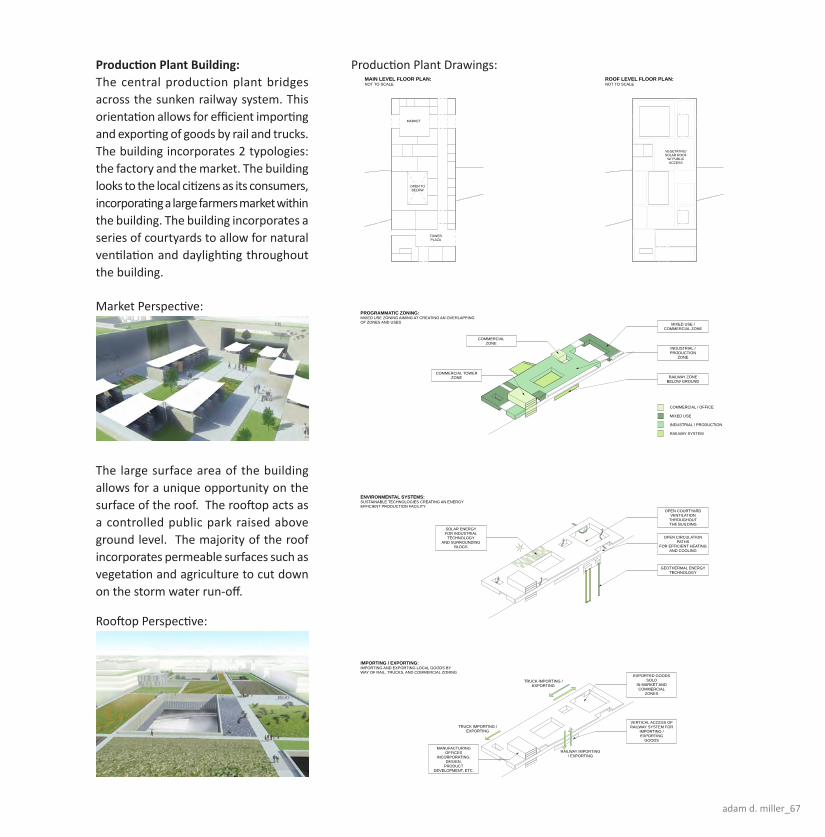
adam d. miller_67
MAIN LEVEL FLOOR PLAN:NOT TO SCALE
ROOF LEVEL FLOOR PLAN:NOT TO SCALE
OPEN COURTYARDVENTILATION
THROUGHOUTTHE BUILDING
OPEN CIRCULATIONPATHS
FOR EFFICIENT HEATINGAND COOLING
SOLAR ENERGYFOR INDUSTRIAL
TECHNOLOGYAND SURROUNDING
BLDGS
GEOTHERMAL ENERGYTECHNOLOGY
MIXED USE /COMMERCIAL ZONE
INDUSTRIAL /PRODUCTION
ZONE
RAILWAY ZONEBELOW GROUND
COMMERCIALZONE
COMMERCIAL TOWERZONE
VERTICAL ACCESS OFRAILWAY SYSTEM FOR
IMPORTING /EXPORTING
GOODS
EXPORTED GOODSSOLD
IN MARKET ANDCOMMERCIAL
ZONES
MANUFACTURINGOFFICES
INCORPORATING:DESIGN,
PRODUCTDEVELOPMENT, ETC.
TRUCK IMPORTING /EXPORTING
TRUCK IMPORTING /EXPORTING
RAILWAY IMPORTING/ EXPORTING
ENVIRONMENTAL SYSTEMS:SUSTAINABLE TECHNOLOGIES CREATING AN ENERGYEFFICIENT PRODUCTION FACILITY
PROGRAMMATIC ZONING:MIXED USE ZONING AIMING AT CREATING AN OVERLAPPINGOF ZONES AND USES
IMPORTING / EXPORTING:IMPORTING AND EXPORTING LOCAL GOODS BYWAY OF RAIL, TRUCKS, AND COMMERCIAL ZONING
COMMERCIAL / OFFICE
MIXED USE
INDUSTRIAL / PRODUCTION
RAILWAY SYSTEM
MARKET TYPOLOGY:AN EMPHASIS ON LOCAL GOODS SUCH ASPRODUCE AND PRODUCTS. LA RAMBLA IS AMARKET IN DOWNTOWN BARCELONA WITHA VIBRANT ATMOSPHERE.
FACTORY BUILDING:THE LARGE SCALE PROVIDES ITEMS FORMASS PRODUCTION THROUGH EFFICIENCY INCOST. THE PRODUCTION ALLOWS FOR LOCALAND GLOBAL EXPORTING OF GOODS.
ASTERIX CONCEPT:
FIVE-FINGER GROWTH: COPENHAGEN, DENMARK
Copenhagen's public transportation system is in the form of five fingers.This spatial organization allows for density along the transportation routeswith agricultural areas between the fingers.
ASTERIX GROWTH: INDIANAPOLIS, INDIANA
Indianapolis' city layout allows for a central light rail system. The future growthfollows the pattern of an asterix. The growth pattern allows for agriculturalareas between the transportation lines. The asterix shape emphasizes equality on all sides, making the south side just as important as the north side.
To Shelbyville
To Lebanon To Fishers
The eastern line will run along East Washington Street, giving suburbancommuters an efficient way to get to the city.
DENSITY GROWTH:
INCORPORATING TOWERS:
The proposed light-rail system provides a guideline for future growth in the city area. East Washington,being directly on axis with the transportation can emphasize this density by incorporating medium-sizedtowers.
INCREASING DENSITY/SCALE
HighDensity
Med.Density
LowDensity
Density growth alonglight-rail transportation
system
REACTIVE ZONING:
EAST WASHINGTON STREET:
As a response to the disconnection of the north and south side of Washington Street, a strategy ofREACTIVE ZONING is incorporated into the design. Reactive
CourtyardReactiveForms
ReactiveProgramming
ReactivePathways
FRAMING THE SKYLINE:
ENTRY TO THE CITY:
Large buildings along Washington Street help frame Indianapolis' skyline as one enters the city. Theseelements emphasize the concept of a gateway to the city.
DowntownSkyline
NorthBuilding
SouthBuilding
Conceptual Perspective of Washington Street Looking West
A CITY OF CIRCLES:Indianapolis is well-known for its circular citycenter. What happens if the circle is copiedthroughout the city varying in SCALE,FORM, and PROGRAM?
Monument Circle:A circular void creating
a significant node inthe city
Water Circle:A recreational or ecologicalelement incorporating water
in an urban environment
Circle Building:A large scale circular building
acting as a center forsurrounding neighborhoods
Green Circle:A vegetative park creatingopen space in an urban
environment
Circle Courtyard:A large scale courtyard
building acts as a center forsurrounding neighborhoods
NORTH / SOUTH SEGREGATION GREY AREAS NEAR RAILWAY
ZONING DISINTEGRATION PASS-THROUGH AREA
MEDIUM DENSITY COURTYARD HOUSING:
The proposed courtyard housing emphasizes density in urban living with the use of shared green spaceand small setbacks. This is a response to the existing single family housing conditions on the site thatare more applicable for suburban areas.
The altering organization allows for diversity in courtyard shapes and sizes. The buildings incorporatesustainable systems such as:
- VEGETATIVE ROOF
- ON-SITE WATER RETENTION
- GEOTHERMAL TECHNOLOGY
- SOLAR ENERGY
BUILDING SECTION A-A:Not To Scale
GREENBELT GATEWAY: A TEMPLATE FORURBAN GROWTHEAST WASHINGTON STREET INDIANAPOLIS, IN
The Greenbelt Gateway is proposed along East Washington Street in Indianapolis, Indiana. This roadway, U.S. 40, used to be a major national east/west passage for cross country travel and transferring of goods.The current state of the site contains: zoning disintegration, grey areas, north/south segregation, and pass through areas. Once a flourishing area of town, East Washington Street decreased in safety and qualityof life as many industrial plants moved out of the area. The Greenbelt Gateway proposes to re-connect these neighborhoods and create a template for growth in regards to public transportation, density, andzoning specifications.
The proposed development incorporates a 4 main design concepts: sinking the railway below ground level, re-routing the river, developing two major parks, and bridging over the railway. The railway is proposedbelow ground level to allow for unobstructed circulation between the north and the south sides of the site. This organization is based on the concept of vertical layering. The nearby river is re-routed onto the siteto create more rainwater overflow areas on the site. The excess soil from digging the railway and river is used to create two city-wide parks on the site. The cultural park bridges over the railway and the circularpark aligns with the monument circle downtown, approximately 4 miles away. As the railway is a major resource for importing and exporting, a series of industrial buildings bridge over the railway to allow forefficient access to the railcars below.
Green Zones:
Elements:Cultural Park, Circle Park, courtyards, vegetativeroofs, and greenways
Description:The master plan incorporates 3 major elements ofGreen Zones: major park space, courtyards, andrecreational greenways. The 2 major parks areconnected by east/west greenways along the sunkenrailway and East Washington Street. The Greenzone decreases water run-off in the area and createsa more ecologically driven micro climate.
Building Program:
Elements:
Cultural
Mixed-Use
Residential
Industrial
Ecological
Description:The existing site maintains a segregation of zones,specifically industrial, residential, and commercial.This segregation creates cultural and physicalbarriers on the site. The proposed developmentaims at overlapping and layering new zones as away of decreasing those barriers. The standardbuilding typology is based on the interior courtyard,allowing for efficient natural light and green space.
Circulation:
Elements:
Highway
Light-Rail Transit
Railway
High-use Roadway
Low-use Roadway
Description:The proposed development lowers the existingrailway below ground level to allow for unobstructedcirculation perpendicular to the railway. Theproposed light-rail system is located along EastWashington Street, connecting the city center withthe surrounding suburbs.
Existing Context:
Elements:
Residential, Industrial, and Commercial Buildings
Description:The surrounding buildings create spatial guidelinesfor the proposed masterplan. The scale of theexisting buildings illustrate a rural scale, that willeventually shift following the proposed development.
FIRST LEVEL FLOOR PLAN :Not To Scale
This housing type is one of (3) incorporated into the masterplan. High density courtyard housing as wellas high density residential towers are added to dense areas of proposed plan. Each typologyincorporates the courtyard concept, emphasizing natural daylighting and vegetation.
ROOF LEVEL FLOOR PLAN:Not To Scale
The roof level incorporates an extensive vegetative green roof as well as a roof pond for retainingrainwater. The roof level is also used for local agriculture.
PRODUCTION PLANT BUILDING:
The central production plant bridges across the sunken railway system. This situation allows for efficientimporting and exporting of goods by rail and trucks. The building incorporates 2 typologies: the factoryand the market. The building looks at the local area as its consumers, incorporating a large farmersmarket within the building. The roof creates a controlled public park and also growing surfaces for localagriculture.
The Greenbelt Gateway, as earlier stated, acts as a template for future growth in Indianapolis. The growth is mainly a response to the incorporation of a light-rail public transportation system following the city'scentral urban layout. The future growth illustrates the transition from suburban sprawl to efficient urban growth. This light-rail transportation system creates a guideline for growth, allowing commuters to efficientlyget to the city's center with the use of public transportation.
The proposed development incorporates a number of environmental elements, aiming at creating an ecologically sensitive area. Approximately 85% of the buildings in the new development incorporate green roofsystems. These green roofs minimize on-site water runoff as well as create a cleaner environment. Geothermal technology is incorporated into a number of the major developments to efficiently utilize the site'snatural resources. Additionally, solar panel systems are placed throughout the development to power the surrounding buildings.
OPEN TOBELOW
MARKET
TOWERPLAZA
VEGETATIVE/SOLAR ROOF
W/ PUBLICACCESS
MARKET
MIXED-USE
MIXED-USE
MIXED-USE
RESIDENTIAL
COMMUNITYBLDG
GREEN ROOF/ROOF POND
Phase One:
Description:The first phase of the development incorporates the major elements of the urban design. Theseinclude: the sunken railway, the light-rail, the 2 major parks, mixed-use and commercialbuildings. The excavated soil from the sunken rail is used to create topography for the twoparks.
Phase Two:
Description:Following the commercial development in Phase One, the residential development is addedalong East Washington Street. Additionally, the major industrial buildings are added along thesunken railway. Phase Two of the parks includes further development.
Phase Three:
Description:Phase Three illustrates the concept of efficient density growth. This density includes the tworesidential towers and further growth along East Washington Street and the sunken railway.
Sunken Rail System
Light-Rail System
Mixed-use Development
Commercial Development
Preliminary Park Development
Industrial / Bridging Development
Continued Park Development
Re-route River onto Site
Residential Towers
Cultural Buildings
Efficient Density Growth
AXON DIAGRAM:Not To Scale
Sun Path
MarketCirculation
Market
Parking Parking
Green Roof
Green Roof
EXISTING CONDITIONS:SITE CONTEXT:
U.S. HIGHWAY 40SITE
EASTBOUND TOWARDBALTIMORE, MD
WESTBOUND TOWARDLOS ANGELES, CA
The site is situated approximately 3 miles east ofmonument circle in downtown Indianapolis. TheGreenbelt Gateway development is between InterstateI-70 and Sherman Street.
WASHINGTON STREET PERSPECTIVE:Framed View Toward Downtown Skyline
ROOFTOP PERSPECTIVE:Production Plant Building
MARKET AREA PERSPECTIVE:Production Plant Building
AERIAL PERSPECTIVE:Greenbelt Gateway Looking East
MONUMENT CIRCLEINDIANAPOLIS, IN
LARGE AMOUNTS OFSUBURBAN GROWTH HAS
OCCURRED ON THENORTH SIDE OF THE CITY
HIGH DENSITY OCCURSALONG INDIANAPOLIS'
HIGHWAY SYSTEM
Production Plant Building:The central production plant bridges across the sunken railway system. This orientation allows for efficient importing and exporting of goods by rail and trucks. The building incorporates 2 typologies: the factory and the market. The building looks to the local citizens as its consumers, incorporating a large farmers market within the building. The building incorporates a series of courtyards to allow for natural ventilation and daylighting throughout the building.
Market Perspective:
Rooftop Perspective:
Production Plant Drawings:
The large surface area of the building allows for a unique opportunity on the surface of the roof. The rooftop acts as a controlled public park raised above ground level. The majority of the roof incorporates permeable surfaces such as vegetation and agriculture to cut down on the storm water run-off.
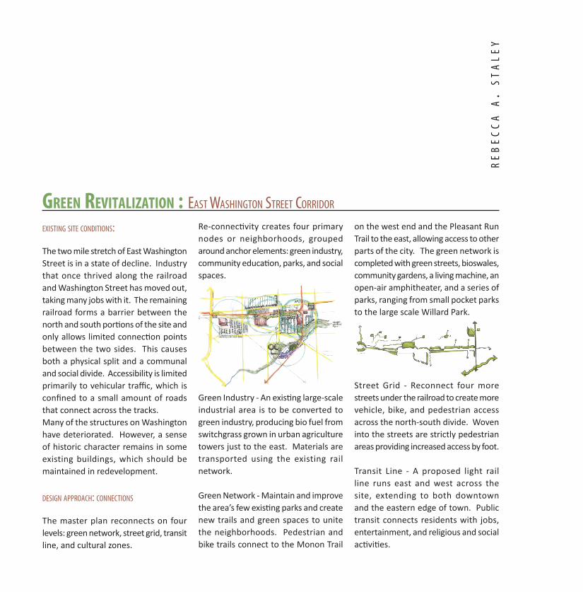
Green revitalization : East Washington strEEt Corridor
Existing sitE Conditions:
The two mile stretch of East Washington Street is in a state of decline. Industry that once thrived along the railroad and Washington Street has moved out, taking many jobs with it. The remaining railroad forms a barrier between the north and south portions of the site and only allows limited connection points between the two sides. This causes both a physical split and a communal and social divide. Accessibility is limited primarily to vehicular traffic, which is confined to a small amount of roads that connect across the tracks.Many of the structures on Washington have deteriorated. However, a sense of historic character remains in some existing buildings, which should be maintained in redevelopment.
dEsign approaCh: ConnECtions
The master plan reconnects on four levels: green network, street grid, transit line, and cultural zones.
Re-connectivity creates four primary nodes or neighborhoods, grouped around anchor elements: green industry, community education, parks, and social spaces.
Green Industry - An existing large-scale industrial area is to be converted to green industry, producing bio fuel from switchgrass grown in urban agriculture towers just to the east. Materials are transported using the existing rail network.
Green Network - Maintain and improve the area’s few existing parks and create new trails and green spaces to unite the neighborhoods. Pedestrian and bike trails connect to the Monon Trail
on the west end and the Pleasant Run Trail to the east, allowing access to other parts of the city. The green network is completed with green streets, bioswales, community gardens, a living machine, an open-air amphitheater, and a series of parks, ranging from small pocket parks to the large scale Willard Park.
Street Grid - Reconnect four more streets under the railroad to create more vehicle, bike, and pedestrian access across the north-south divide. Woven into the streets are strictly pedestrian areas providing increased access by foot. Transit Line - A proposed light rail line runs east and west across the site, extending to both downtown and the eastern edge of town. Public transit connects residents with jobs, entertainment, and religious and social activities.
rE
bE
CC
a a
. s
ta
lE
y

rebecca a. staley_69
Community Center
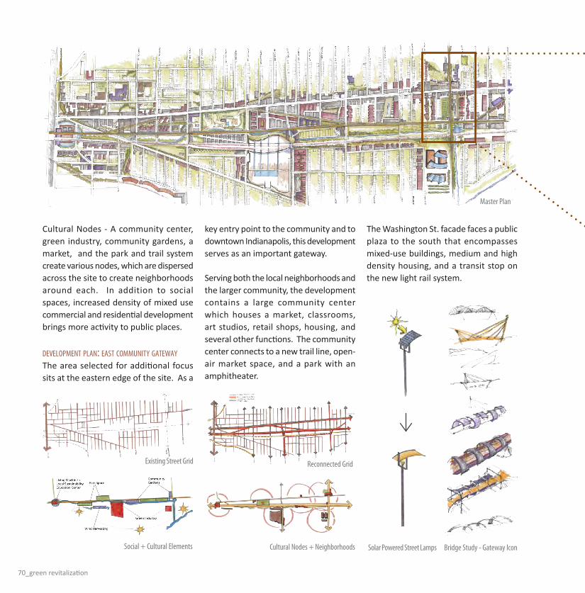
70_green revitalization
Cultural Nodes - A community center, green industry, community gardens, a market, and the park and trail system create various nodes, which are dispersed across the site to create neighborhoods around each. In addition to social spaces, increased density of mixed use commercial and residential development brings more activity to public places.
dEvElopmEnt plan: East Community gatEWayThe area selected for additional focus sits at the eastern edge of the site. As a
key entry point to the community and to downtown Indianapolis, this development serves as an important gateway.
Serving both the local neighborhoods and the larger community, the development contains a large community center which houses a market, classrooms, art studios, retail shops, housing, and several other functions. The community center connects to a new trail line, open-air market space, and a park with an amphitheater.
Master Plan
Reconnected Grid
Social + Cultural Elements Cultural Nodes + Neighborhoods Bridge Study - Gateway IconSolar Powered Street Lamps
Existing Street Grid
The Washington St. facade faces a public plaza to the south that encompasses mixed-use buildings, medium and high density housing, and a transit stop on the new light rail system.

rebecca a. staley_71
Integrated along the transit line are multiple public functions: bike and pedestrian trails, a rain water management system, parks, gardens, and commercial development emphasizing alternative transportation methods.
The deteriorated railroad tracks running north and south over Washington St. will be converted into a trail similar to the Monon. This new trail intersects with the east-west trail and transit line and the community center. New development including shopping, restaurants, gardens, a market, and housing are focused on the trail lines.
dEvElopmEnt ConsidErations
Housing - Several areas of single family housing provide a strong residential core. With minor maintenance and in-fill construction, these neighborhoods remain a valuable piece of the community. In addition to maintaining existing housing, new multi-family units are woven into the voids, bringing new density to support jobs and social activities.
Green Streets - Main streets will be lined with bioswales and designated bicycle and pedestrian areas. Traffic in many areas will include single lanes of travel in each direction with on-street parking for ease of access to local businesses.
Sustainability - Buildings with south-facing solid surfaces will contain photovoltaic panels, while those with south-facing glass will feature louvers and shades to optimize daylighting.
Development Plan

72_green revitalization
Water will be collected from roofs to feed gray water systems. Where applicable, green roof trays will absorb rain fall. Pedestrian areas will be paved with permeable surfaces to reduce run-off.
arChitECtural piECE - Community CEntEr
Function - As the eastern anchor of the community, the new center will hold a central market for both local and regional vendors, retail spaces, community education opportunities, artist studios, and a public library. Housing is integrated into the building to provide activity and community presence day and night.
The center will be supported by the immediate community through daily programming and the greater Indianapolis area through special events.
Form - Two intersecting atria connect the community center to various areas within the larger development. Sun shades and operable vents provide passive heating, cooling, and lighting to the space.
The Washington St. and Gale St. facades reflect traditional small to medium scale urban development themes, while the trail facade addresses new alternative transit-oriented culture.
Multi-functional roof spaces work to collect water, provide solar power, reduce heat island effect, daylight the interior, and provide usable, educational space for building occupants.
Top: Typical street section
Bioswales, solar energy, alternative transit, and mixed-use development.
Left: Community Center Concept
Public market and transition spaces form cross axes to connect commercial space (south and east sides), education (northeast), and residential (northwest). North-south axis extends to school, while east-west axis joins outdoor market space.
Bottom: Schematic planning
Primary public functions on first and second floors.Private studios and housing above.

rebecca a. staley_73
Top Left: Sustainable qualities within Community Center + building metabolism
Bottom: Community gateway point on Washington St. facing west
New AgriculturAl urbAN MAiN Street: east washington street neighborhood renewal
The two and one half mile stretch of the East Washington Street corridor just outside of downtown Indianapolis, Indiana is currently in a state of dilapidation. It has several issues contributing to its decaying state as a neighborhood. The current residents of the neighborhood seem to mostly be of lower middle class economic standing. They could all benefit from a revitalization effort focusing on creating a 24/7, live, work, and play community. East Washington Street is totally centered around the automobile as a main form of transportation around the site. It lacks urban density, which is an essential element of urban vitality. Many of the buildings on site are dilapidated and several of them have not been designed to suit a walkable neighborhood. There is no reliable transit system in place to get residents to places on site as well as to the downtown area. The neighborhood is currently not bikeable or walkable, which also limits the number of residents who have access to all places in the neighborhood.
Since East Washington Street and its surrounding area lacks the urban density it needs to survive as a productive community, it is a land of opportunity in design. It should become a 24/7 community to suit the current American lifestyle of living, working, and playing at all hours of the day and night. There should be a light rail transit line weaving throughout the neighborhood to facilitate transportation needs for community members. The existing rail road track should also be utilized to connect with other cities and transport goods to and from the site. Auto traffic should be limited on the site and parking should be moved under ground. The community should be made more sustainable by incorporating and combining harvesting elements such as rainwater collection, solar, collection, and urban agriculture principles. The ring of activity concept is used as an organizing principle for this design proposal. It explains how each node within a five minute walk becomes practical and functional for the people
living, working, and playing within it. First, it integrates daily, weekly, and specialty needs, thus eliminating isolation for those who do not have access to personal vehicles. Second, it mixes socio-economic classes creating a socially sustainable community where everyone can contribute in a different way. Finally, it creates opportunities to contribute to the city through urban agricultural practices.
as
hl
ey
Va
nM
et
er
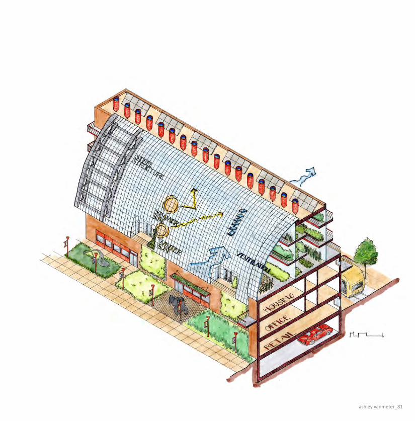
ashley vanmeter_81

82_new agricultural urban main street
Phase 1: MASTER PLAN
vicinity map
existing traffic patternswalkable nodes of activity concept
existing figure ground
master plan proposal
existing reverse figure groundexisting site (source: google earth)
ashley vanmeter_83
Phase 2: DEVELOPMENT PLAN
Daily Needs -Residential Space -Working Space -School -Fitness Center -Grocery Store -Coffee Shop -Library
Weekly Needs -Laundry Facility -Restaurants -Barber -Religious Facilities -Retail Space -Bar/Nightclub -Bank -Park
Specialty Needs -Medical Facilities -Movie Theater -Sporting Event

84_new agricultural urban main street
Phase 3: ARCHITECTURE
Urban Agriculture -The Science, recreation, or sustainable practice of cultivating, processing, or distributing food by integrating contemporary building technologies.
High Density Mixed-Use Development -Combining living, working, and playing spaces into a single structure to promote an environment conducive to a 24/7 lifestyle.
Pedestrian Friendly Transit Line -Inserting a light rail system in place of the traditional automobile street to promote a culture receptive to walking, biking, or using public transportation for moving throughout the city.
greenhouse interior perspective
transit perspective
ashley vanmeter_85
solar collection
circulation
water collection and distribution
green space micro-drip irrigation system
sectional axon


review sessions_87