Embed Size (px)
Citation preview
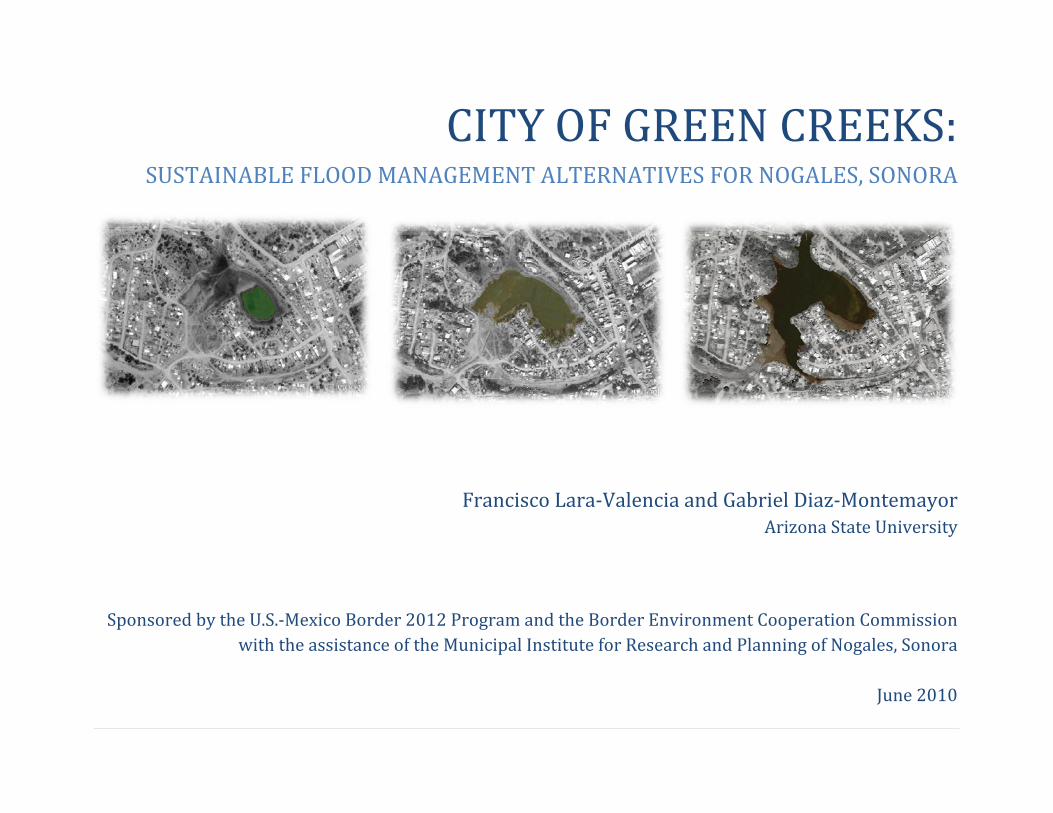
CITY OF GREEN CREEKS: SUSTAINABLE FLOOD MANAGEMENT ALTERNATIVES FOR NOGALES, SONORA
Francisco Lara‐Valencia and Gabriel Diaz‐Montemayor Arizona State University
Sponsored by the U.S.‐Mexico Border 2012 Program and the Border Environment Cooperation Commission with the assistance of the Municipal Institute for Research and Planning of Nogales, Sonora
June 2010
Contents Executive Summary
1 Introduction 3 Background and Context 3 Current problems 6 The power of forgotten waterways 9 Flood management systems 11 Sustainable Flood Management Strategies 12 Vegetated roofs 12 Bioretention 12 Green streets and sidewalks 13 Permeable pavements
13 Rain gardens / infiltration ponds 15 Wetlands 17 A Green Infrastructure Network for Nogales 18 Proposed green network 22 Green nodes and corridors 27 Exploring the Possibilities 28 Las Ardillas Neighborhood Park 30 Chimeneas Park 32 El Ranchito de los Alisos 34 Monumentos de Piedra City Park 38 El Rehilete Neighborhood Park 40 El Nogal Regional Park
42 Colosio Green Corridor 45 Parque Comunidad 47 Nuevo Nogales Linear Park 49 Arroyo Cuesta Blanca Green Development

52 Implementation 55 Summary and Recommendations 57 References 59 About the Authors and Contributors 61 Acknowledgments
Executive Summary Stormwater and flood management in Nogales, Sonora, requires long‐term, cost‐effective, and community‐based solutions involving all sectors of society and levels of government. Effectively engaging all sectors in multiscale green network solutions can help the city to balance growth trends with urban livability and environmental and civil protection needs.
This report presents green infrastructure strategies that could be applied in Nogales to reduce stormwater runoff volumes while allowing for economic growth and creating attractive, livable neighborhoods. These strategies have proven effective in other cities around the world and, because their flexibility, can be adapted to rapidly growing cities like Nogales. Some core concepts ground the strategies: First, flooding management should address the underlying factors of the problem using a combination of tools ‐structural and non‐structural‐ that are sensitive to the local context. Second, open space should be preserved in ways that improve water quality and wildlife habitat while providing residents with opportunities to enjoy nature and participate in recreational activities. Third, by directing growth to already developed areas, land and urban infrastructure can be used more efficiently saving public and private resources.
An essential ingredient for the implementation of these strategies is controlling where urban development takes place and how the city is being built. The report, therefore, looks at land use approaches, such as green network planning, as a way to contain urban dispersion and fragmentation. This approach not only manages stormwater but it also creates spaces that invite residents to interact with nature and reconnects built and natural environment in a sustainable way.
The core of the report illustrates innovative, site‐level design strategies for specific places in Nogales. These design strategies illustrate the report’s goal ‐ to provide the city with environmentally responsible planning and design alternatives that can reduce runoff volume, protect water resources, preserve riparian habitats, and offer the additional community benefit of creating more interesting places to live, work, and play.
1 | P a g e
Introduction This report is intended to help the City of Nogales, Sonora, to manage and reduce its stormwater runoff while still allowing the city to grow and prosper with more homes, businesses, and jobs. We believe that where and how development occurs in the city can dramatically affect the Nogales watershed, wastewater treatment systems, and water supplies. It can also affect the quality of life of current and future residents because urban form and land use affect flood hazards and open‐space availability. Our goal is to influence the dominant paradigm of urbanization in Nogales by advocating for and illustrating green infrastructure solutions’ potential for creating a more sustainable future by better balancing development decisions and environmental protection.
“Green infrastructure solutions” refers to an array of tools used to reduce runoff by restoring disturbed natural areas in cities and minimizing the impact of new development on the natural landscape. It has been demonstrated that green infrastructure solutions can reduce and eliminate the need for large investments to control stormwater runoff and protect water quality. These strategies utilize open space that can double as flooding control devices and public parks that help to enhance the safety, aesthetic, and economic value of property in the surrounding area. Finally, green infrastructure solutions cost less than conventional development techniques and allow for more flexible and cost‐effective site layouts. The report explores some of these tools and evaluates their potential in the context of Nogales, a city that presents unique challenges and opportunities. In brief, the research work conducted in Nogales suggests that a successful flood management plan based on green infrastructure solution should address the following requirements:
Proposed solutions should capture the interest and commitment of all relevant sectors in the city, including citizens, elected officials, landowners, developers, professionals, community leaders, and so forth.
The strategy should be able to connect top‐down with bottom‐up analyses and respond to the interaction between incremental lot‐scale decisions and urban and higher‐level decisions on land development.
The solutions should be meaningful to a wide range of stakeholders, by addressing common urban problems and providing evidence of potentially positive outcomes.
The strategy should be based on tools that are accessible and relatively inexpensive to acquire and easy to implement by individual citizens, businesses, land developers, and city planners.
2 | P a g e
This report brings to the forefront all challenges and opportunities in an attempt to initiate a community‐wide dialogue in Nogales that is sensitive to existing decision‐making models and to gradually introduce innovative urban planning and stormwater management practices.
In the first chapter, we examine the current flooding problems affecting the city of Nogales, and we highlight its underlying factors as well as the need to change the way it is addressed. The second chapter introduces the concept of sustainable flood management and some of the green infrastructure tools that can be implemented in Nogales to address stormwater, ecology, and open‐space problems in a comprehensive manner. Chapter 3 summarizes the results of a land suitability analysis conducted to identify the nodes and corridors of an eco‐network that could be used by Nogales to deploy green infrastructure solutions as a part of multiscalar and city‐wide flood control strategy. The fourth chapter briefly sketches the planning and design strategies envisioned as potential green infrastructure interventions in 10 sites studied as part of the project and identified through the land suitability analysis. The last two chapters discuss the challenges of implementing green infrastructure solutions in Nogales, and they provide some recommendations.
3 | P a g e
Background and Context Current problems
The City of Nogales, Sonora, was officially established in 1884 in the low‐lying reaches of the Arroyo Los Nogales and its tributaries (Flores, 1987). The advantages of locating the city here are apparent in the proximity of the international border, the availability of water, and the ease and low cost of clearing and grading for construction of buildings and rights‐of‐way. Over decades of development, the economic benefits provided by the location near the floodplain of the Arroyo Los Nogales watershed attracted private and public investment in houses, shops, school, roads, parks, and structures to control storm water runoff. This attracted people who came to live, work, study, shop or play in these developments, and the level of human activity there became more intense and diverse over time. The continued occupation of land on or near floodplains is not unique to Nogales, yet it creates serious flooding risks and vulnerabilities. Storm‐water and flood hazards have been a recurrent concern in the history of Nogales, and they occur more frequently and severely as the area’s rate of urbanization increases. As the city expands, more roads and roofs are added to the impervious area created by urbanization, which in turn increases the volume and speed of surface runoff during the wet weather seasons in the summer and winter. The amount of rainwater that falls in the watershed and the speed with which it reaches downtown and the neighborhoods in the lowlands determine if and when flooding occurs. The impact of weather‐related events is a function of the level of people and property exposed to the corresponding hazard. Therefore as the concentration of people, jobs, and building increases, the risk of damage by storm water runoff and flooding also increases. Flooding has severe negative effects on businesses, families, and the community of Nogales, in general, because they dislocate economic activities, discourage tourism, disrupt daily life, create health problems, damage property, destroy public infrastructure, and harm the environment. The most common effects of flood on Nogales are:
Damage or destruction of water mains and interruption of water supply in homes, businesses, schools, and hospitals. Damage or destruction of the sewage systems and untreated wastewater spills on streets and properties. Power outages and interruption of communication services. Interruption of public transportation and closure of streets affecting the mobility of employees, consumers, students, and
other people.
4 | P a g e
Damage or destruction of houses, buildings, and city structures. Illness, disease, and loss of life affecting mainly children, senior citizens, and other vulnerable populations. Expensive cleanup of sediments, trash, and other debris from streets and properties. Adverse effects on the aesthetics and image of the city. Disturbance of wildlife habitats. Contamination of groundwater and rivers and degradation of soils and air quality. Soil erosion, soil instability, and mudslides
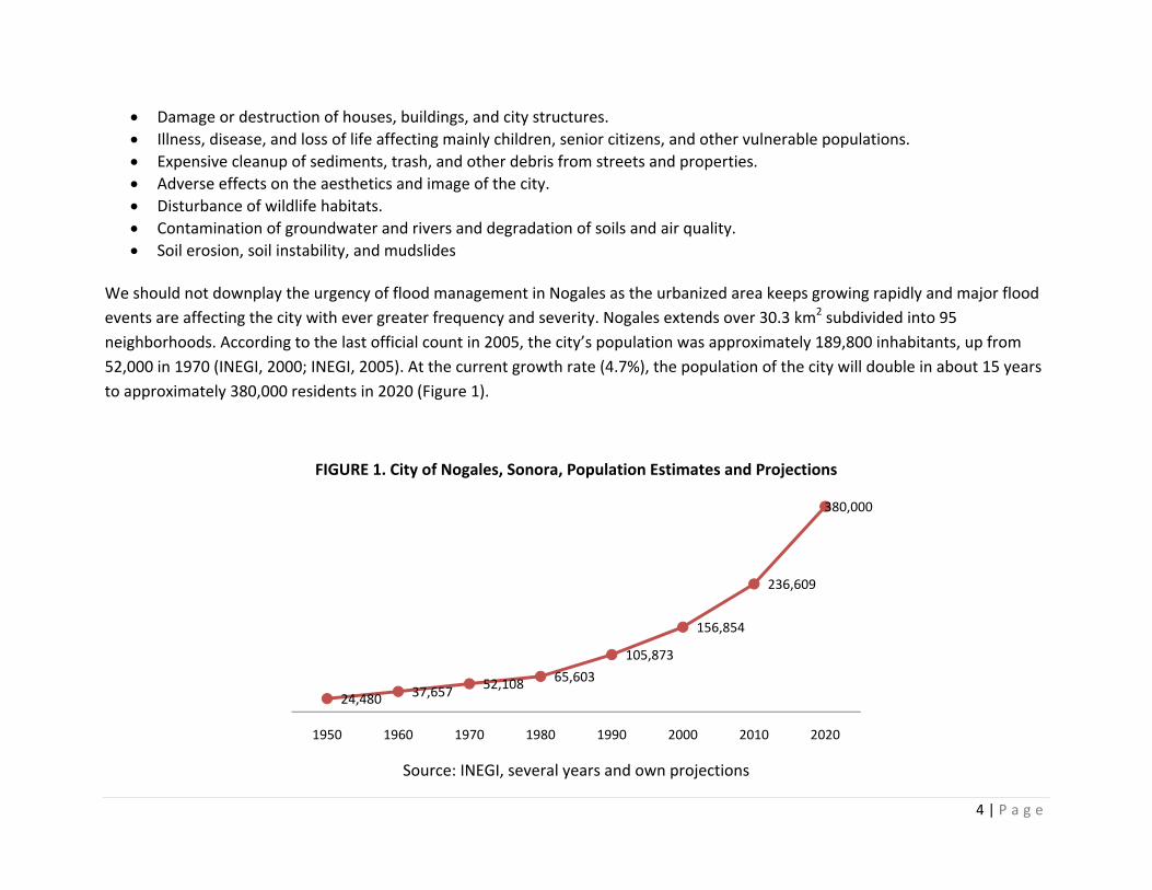
We should not downplay the urgency of flood management in Nogales as the urbanized area keeps growing rapidly and major flood events are affecting the city with ever greater frequency and severity. Nogales extends over 30.3 km2 subdivided into 95 neighborhoods. According to the last official count in 2005, the city’s population was approximately 189,800 inhabitants, up from 52,000 in 1970 (INEGI, 2000; INEGI, 2005). At the current growth rate (4.7%), the population of the city will double in about 15 years to approximately 380,000 residents in 2020 (Figure 1).
FIGURE 1. City of Nogales, Sonora, Population Estimates and Projections
Source: INEGI, several years and own projections
24,480 37,657 52,108 65,603
105,873
156,854
236,609
380,000
1950 1960 1970 1980 1990 2000 2010 2020
5 | P a g e
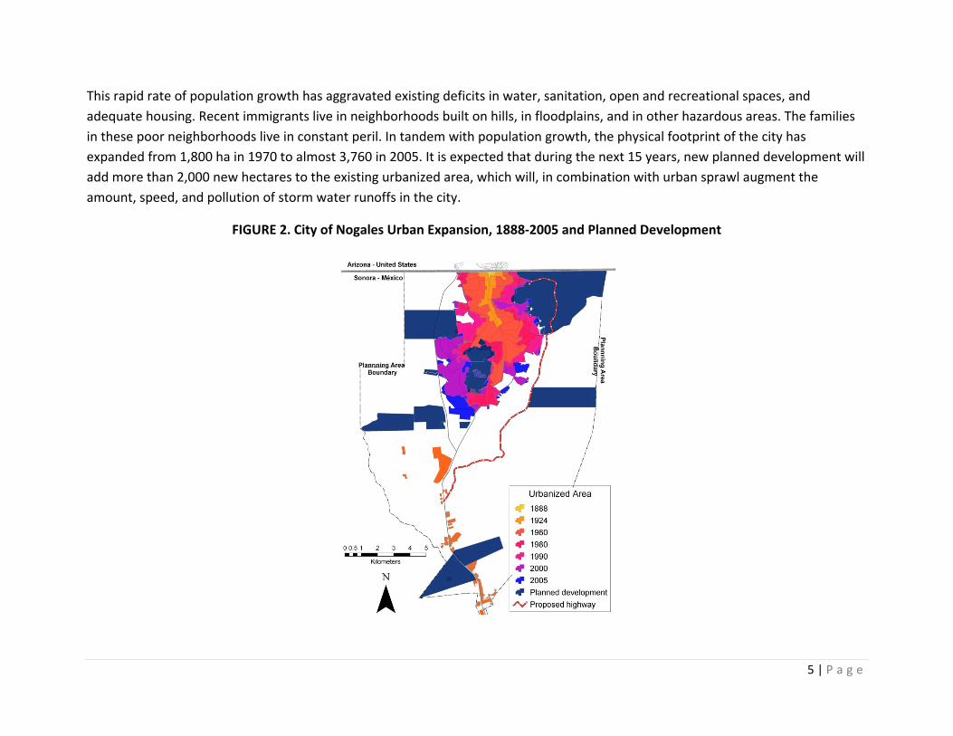
This rapid rate of population growth has aggravated existing deficits in water, sanitation, open and recreational spaces, and adequate housing. Recent immigrants live in neighborhoods built on hills, in floodplains, and in other hazardous areas. The families in these poor neighborhoods live in constant peril. In tandem with population growth, the physical footprint of the city has expanded from 1,800 ha in 1970 to almost 3,760 in 2005. It is expected that during the next 15 years, new planned development will add more than 2,000 new hectares to the existing urbanized area, which will, in combination with urban sprawl augment the amount, speed, and pollution of storm water runoffs in the city.
FIGURE 2. City of Nogales Urban Expansion, 1888‐2005 and Planned Development
6 | P a g e
It would be unrealistic to think in terms of the complete elimination of flood hazards in the city, but their disastrous consequences can be reduced through sustainable flood management solutions. Sustainable flood management is a broad spectrum of water management actions, urban planning, and community participation aimed at reducing potential harmful impacts of floods on people, the economy, and the environment of Nogales. For flood management to be truly sustainable, it must be integrated into the planning for a wide range of complex human, social, economic, and environmental dimensions that often interact with one another. As suggested by Andjelkovic (2001), a sustainable flood management strategy focuses on “preventions rather than on cure of water quantity and quality problems” and addresses the needs of different social groups “without passing on cost to other people in space or time.” Traditional flood management has not tended to do this, as it focuses more on technical solutions guided by economic or risk‐reduction aspects. This has lead to unsustainable approaches that have often increased loss of life and damage to property, infrastructure, and development as well as degradation of the environment and the social and cultural basis of communities (Tucci, 2007). It is Increasingly recognized that this must change, and the role of the environment in flooding and its interactions with other areas where risk might be experienced must be addressed (Freitag et al., 2009; EPA, 2006). The main goal of City of Green Creeks is to inspire local leaders and citizens to adopt innovative, comprehensive, cost‐effective, and long‐term solutions to the city’s flooding problems. This document is the result of researchers and local planners collective search for environmentally sound and quality‐of‐life‐enhancing solutions to the current problems posed by rapid and incomplete urbanization in Nogales. It is intended to provide guidance to developers, landowners, planners, citizens, or city officials who want to apply sustainable approaches to flood management in already‐urbanized areas of Nogales. Furthermore, considering the city’s pace of development, the people of Nogales might decide to adopt the concepts and strategies proposed here.
The power of forgotten waterways
The City of Nogales is located in a narrow valley surrounded by mountainous terrain. A major but intermittent waterway, the Arroyo Los Nogales (Nogales Wash), runs through it. In Mexico, the lowest portion of the alluvial valley formed by the Nogales Wash is about 0.75 km wide in the proximity of the international border. The watershed basin created by the Nogales Wash extends across the Mexico‐U.S. border and encompasses over 235 km2, divided almost equally between Sonora and Arizona (Brady et al., nd). The watershed begins 12 km south of the international border and extends east to west forming a trapezoid. The upper watershed is bounded by the Las Avispas mountain range on the west, the Sierra del Pinito mountains on the east, the Arizona community of Rio
7 | P a g e
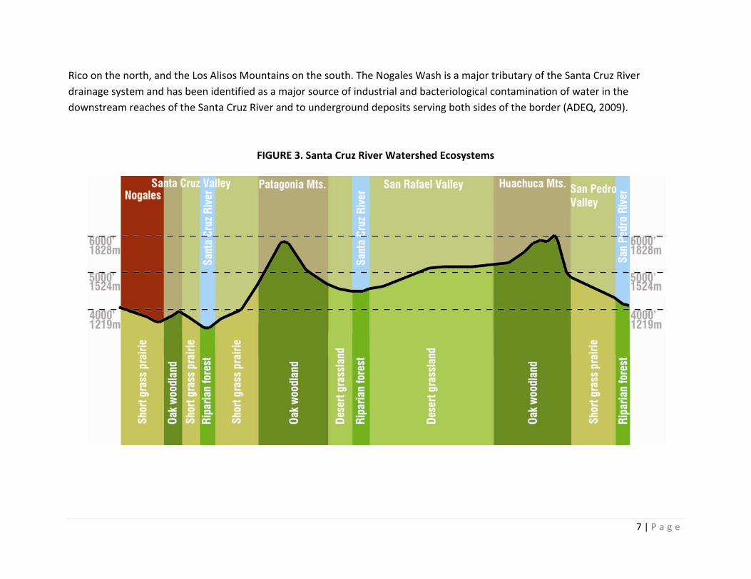
Rico on the north, and the Los Alisos Mountains on the south. The Nogales Wash is a major tributary of the Santa Cruz River drainage system and has been identified as a major source of industrial and bacteriological contamination of water in the downstream reaches of the Santa Cruz River and to underground deposits serving both sides of the border (ADEQ, 2009).
FIGURE 3. Santa Cruz River Watershed Ecosystems
8 | P a g e
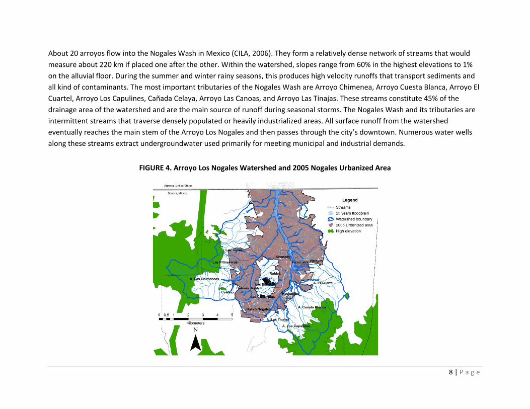
About 20 arroyos flow into the Nogales Wash in Mexico (CILA, 2006). They form a relatively dense network of streams that would measure about 220 km if placed one after the other. Within the watershed, slopes range from 60% in the highest elevations to 1% on the alluvial floor. During the summer and winter rainy seasons, this produces high velocity runoffs that transport sediments and all kind of contaminants. The most important tributaries of the Nogales Wash are Arroyo Chimenea, Arroyo Cuesta Blanca, Arroyo El Cuartel, Arroyo Los Capulines, Cañada Celaya, Arroyo Las Canoas, and Arroyo Las Tinajas. These streams constitute 45% of the drainage area of the watershed and are the main source of runoff during seasonal storms. The Nogales Wash and its tributaries are intermittent streams that traverse densely populated or heavily industrialized areas. All surface runoff from the watershed eventually reaches the main stem of the Arroyo Los Nogales and then passes through the city’s downtown. Numerous water wells along these streams extract undergroundwater used primarily for meeting municipal and industrial demands.
FIGURE 4. Arroyo Los Nogales Watershed and 2005 Nogales Urbanized Area
9 | P a g e
Even though the local, state, and federal governments have made important efforts to build a system of retention dams along some of these streams, flooding hazards remain a serious problem for the city. In 2005, the city’s footprint covered 51.1% of the Arroyo Los Nogales Watershed area. Downtown Nogales and many neighborhoods are built on the floodplain of the Arroyo Los Nogales and its tributaries, and these places fall within the boundaries of the 25‐year floodplain established by the Atlas of Natural Hazard of Nogales, Sonora (UNISON, 2006). Major floods have swept through Nogales since shortly after its founding until as recently as 2008. In 1930, a major flood took four lives, caused much property damage, and provided the impetus to get the federal governments of Mexico and the United States to design and build a joint flood‐control project. On the Mexican side, the current flood‐control system consists mainly of a covered channel, the Nogales Wash Tunnel, running next to the arroyo. It has the capacity to discharge runoff produced by storms with a 14‐year‐return period. In 1994, Nogales also experienced a storm that led to a major flood that killed three people and had economic consequences because houses were destroyed and the International Wastewater Treatment Plant in Rio Rico, Arizona, was damaged. The July 2008 storm caused extreme damage that has, as yet, to be fully assessed. Merchants in downtown Nogales experienced considerable losses from the flooding in the Elias District and the closure of the area due to the structural damage to streets and the Nogales Wash Tunnel.
Flood management systems
To mitigate flooding and storm‐water pollution caused by urban runoff, cities need to establish flood management systems. These systems require high levels of public investment, and many cities on the U.S.‐Mexico border postpone infrastructure construction because of pressing needs in other aspects of urban development. However, the increasing incidence and severity of flood damage in recent years as a result higher rates of urbanization and weather variability in the region, as well as an increased awareness and understanding of nonpoint source pollution, have focused attention on urgently needed construction of storm water control systems. The experience of Nogales, Sonora, illustrates this circumstance very well. Implementation of various structural and nonstructural methods can help control storm‐generated flows and the pollutants they can carry (Freitag et al., 2009). Nonstructural methods rely on tools like education, public participation, urban design, planning
10 | P a g e
regulations, and incentives, all of which can alter human interaction with the city’s ecology. Traditional structural methods focus mostly on engineering solutions that modify flooding or provide protection against flooding, such as dams, storage reservoirs, dikes, flood diversion, and land‐treatment practices. As mentioned above, conventional structural solutions, when used in isolation, do not fully address the problem of flooding because they are not designed to control runoff at the source nor to prevent or reduce the contamination of storm‐water runoffs before they enter watercourses. Moreover, structural measures usually have a high monetary cost even though they create a false sense of security because their capacity to overcome hazards is limited (Burby, 2007).
Contemporary flood management concepts address the problem of urban flooding by considering the best mix of flood management options available, selected from nonstructural solutions and conventional structural tools (EPA 2000). At the heart of a balanced and integral flood management strategy lies the identification of the true cause of urban flood problems, the understanding of existing opportunities and constraints faced by alternative strategies, the setting of corresponding goals and objectives, and finally, the establishment of policies and priorities that will guide the overall effort. An increasingly accepted path for the development of an integral flood management strategy starts with the gradual introduction of small‐scale and cost‐effective interventions aimed at reducing storm water runoff control at the source, recovery of wetlands, erosion control, and restoration of urban ecosystems as part of larger flood control program. Some of these interventions are described next.
11 | P a g e
Sustainable Flood Management Strategies In recent years, interest in management approaches that are able to reduce flow rates and minimize nonpoint source pollution during a storm event has grown rapidly (EPA, 2000). One such approach is Low Impact Development (LID). The primary goal of LID is to reduce runoff volume by infiltrating rainfall water into the subsurface and groundwater, evaporating rainwater back into the atmosphere, and finding beneficial uses for the runoff, rather than exporting it as a waste product down storm sewers. Using a systems approach that relies on natural landscape functions, LID solutions integrate land and infrastructure management at the residential‐lot level. The approach generally involves grading minimization, impervious area disconnection, increasing flow lengths, increasing time of concentration, and increasing opportunities to mimic pre‐existing hydrology. The underlying philosophy of LID is the use of many small treatment areas and methods scattered throughout the watershed rather than regionalization of just few larger treatment facilities. These small interventions have the potential to create interconnected nodes and sites of multifunctional green infrastructure network to control storm water in a sustainable way.
In the case of cities like Nogales, LID planning and design can help restore the pre‐development hydrologic regime while reducing pollutants. Unlike other approaches, LID emphasizes cost‐effective, parcel‐level strategies that replicate pre‐development hydrology and reduce the impacts of development (EPA, 2000, Wise 2007). By addressing runoff close to the source, LID can enhance the local environment and protect public health while saving developers and local government money. Instead of large investments in complex and costly engineering strategies for storm water conveyance and management, LID strategies integrate green space, native landscaping, natural hydrologic functions, and various other techniques to generate less runoff from developed land. Ultimately, this approach to flood management can reduce flood hazards, preserve critical ecological services, and provide urban residents opportunities for outdoor recreation (EPA 2000, Wise 2007).
While most engineering plans pipe water to low spots as quickly as possible, LID uses microscale techniques to manage precipitation‐generated runoff as close to where water touches the ground as possible. This involves strategic placement of linked parcel‐level controls that are “customized” to reduce flow rate, volume, and pollutant loads.
Common LID methods include rain gardens and bioretention, green roofs, sidewalk storage, vegetated swales, buffers and strips, rain barrels and cisterns, porous pavement, and impervious surface reduction and disconnection.
12 | P a g e
Vegetated Roof
Green roofs are an important tool for reducing storm water runoff from industrial, commercial, and residential buildings. They use vegetation and specifically designed lightweight soil mixtures to absorb, filter, and detain precipitation. Compared with traditional asphalt or metal roof systems, green roofs are much more effective because they reduce peak flows and absorb and store precipitation, facilitating evapotranspiration. Coupled with other storm water management strategies, they can be effective in helping to eliminate or significantly reduce off‐site discharge. Green roofs may also assist in reducing the introduction of pollutants due to the organic processes of soils and their utilization by plants. Green roofs are being used extensively in Europe and recently in the United States because they offer a variety of benefits, such as extending the life of roofs, reducing the cost of energy, and conserving valuable land that would otherwise be required for storm water runoff control (EPA 2000). Green roofs are most easily and affordably installed with initial construction of a building. However, storm water retrofit is possible with some buildings after they are constructed. Many flat‐roofed buildings can be adapted for the additional weight of green roofs without significant structural modification (US EPA, 2000b; Cook, 2007).
Bioretention
Bioretention is a technique that relies on soils and vegetation to attenuate the volume and speed of storm water runoff and remove pollutants from flows before they reach recharging areas within watersheds (EPA 2000). This technique is often used to store and treat storm water that has run over impervious surfaces, collecting contaminants. Runoff is filtered and may percolate through to the water table or evapotranspire. Runoff can also be stored and be released over a longer period of time. It is a useful strategy for median strips, parking lot islands, and swales. Benefits include enhanced water quality in downstream areas and moderated peaks in storm water discharge. Additional benefits include shade, windbreaks, noise absorption, wildlife habitat, and aesthetic value. There are a range of configurations employed, but ideally, the treatment area may consist of a grass buffer strip, a sand edge and base, a ponding area planted with vegetation, and an organic layer to degrade petroleum‐based pollutants (EPA 2000). The size of bioretention areas is a function of the drainage area and runoff generated (Cook, 2007).
Green streets and sidewalks
Narrower streets, elimination of curbs and gutters, and green sidewalks are strategies that have significant environmental benefits, while in many cases reducing development costs. Narrow streets, by reducing the amount of impervious cover, limit storm water runoff and the amount of pollutants reaching recharge areas. Neighborhoods may have greater aesthetic appeal and bringing houses closer together might facilitate greater interaction and sense of community. The elimination of parking spaces resulting from
13 | P a g e
narrower streets can be offset with shared parking space built using permeable pavement materials. Replacing curbs and gutters with grass or vegetated swales to carry runoff allows storm water to be dispersed directly to swales for infiltration rather than having it collect on the street with no possibility for removing pollutants. Eliminating curbs and gutters will typically require installation of a grass or vegetated swale to accept the storm water runoff from the street. Traditional curbs and gutters are very effective at quickly collecting and delivering storm water runoff to a central location for storage and possibly treatment. Elimination of curbs and gutters and the introduction of grassed swales to collect and convey runoff are suitable for a range of conditions. Where adequate space exists and traffic conditions will allow, this approach enables filtering, percolation, and reduction of peak runoff volumes and flow velocity.
Permeable pavements
One of the principle contributors to increase in urban storm water runoff is the extensive asphalt or concrete paving typically used in streets, parking lots, and sidewalks. Alternatives to these traditional materials exist and offer significant environmental benefits. For example, porous paving is permeable pavement that has some of the same structural characteristics as traditional paving materials but allow storm water to infiltrate directly into a treatment zone or reservoir. It may substitute for traditional paving in light traffic areas, such as driveways, parking lots, and sidewalks, provided the subsoils have adequate permeability rates (1.3 cm or 0.5 inches/hr) and groundwater conditions (1.2 m or 4 feet from the bottom of the system) (US EPA 1999). Porous pavement is often constructed over a stone or gravel reservoir that allows for temporary storage and some filtering before it continues draining into the subsoil. Other alternative paving systems include paving blocks, cobbles, gravel, or mulch. All these systems provide environmental benefits that are superior to traditional concrete or asphalt paving. The environmental benefits vary depending on the system used, but all have the potential to increase percolation of storm water and reduce volume and velocity of runoff. For example, although cobbles are less effective than gravel or mulch for allowing infiltration of storm water, the gaps between stones and the increased roughness of the surface of the stone provide greater infiltration potential and will to some degree reduce the storm water velocity.
Rain gardens / infiltration basins or ponds
A rain garden consists of a shallow depression that collects rainwater and stores it for infiltration back to the aquifer. It is often vegetated with native plants that have the capacity to tolerate occasional flooding. These gardens can blend in with the existing landscape and their design can be formal or informal. However, a natural‐looking design is preferred, as it reveals natural processes in the form of plant communities that build up on time. Rainwater can be captured from any rooftop area, patio, small basin, and
14 | P a g e
other impermeable surfaces. The amount of water collected is a function of the size of the collection area, the amount of rain received, and the losses resulting from evaporation. Rainwater can be stored efficiently in simple or expensive systems.
Berms and swales or gutters and downspouts can be designed to catch rainwater and distribute it directly to tree wells or landscape plants around or close to the rain garden. Rainwater can also be directed to perforated pipes, rock lined trenches, and allowed to infiltrate into the soil.
Infiltration basins
These shallow basins are designed to reduce surface runoff rates thereby reducing storm water hazards downstream. By infiltrating water into the aquifer, these basins have improve water availability and urban and suburban ecologies. Infiltration also improves the quality of the water that is replenishing the aquifers. Design of these infrastructures is very similar to retention and detention facilities. Infiltration basins are more effective when used in tandem with sedimentation basins in order to maintain a functional infiltration capacity, since sediments would clog or collapse the filtering processes. It is important to locate these infrastructures at points where existing soil layers allow for the infiltration of water into the aquifers. Infiltration basins are built in areas where intake storm water is not polluted in order to avoid contamination of the aquifers. These basins are often designed with a dual purpose of detention and infiltration.
Infiltration basins are not very different from pond and rain gardens. However, whereas an infiltration basin requires the construction of an embankment and excavation or damming, rain gardens are built as excavated depressions in the landscape.
Sedimentation basins
These basins are designed to catch eroded soil, materials, and pollutants carried by storm water flows. While still retaining, stopping, and storing water whenever there is a storm event, their main function is to filter water going through their inlet and outlet points therefore improving the quality of water going down the stream into infiltration, retention, and detention infrastructures, as well as into wetlands. Accessibility for large vehicles is necessary in order to remove surplus sedimentary material and to perform maintenance activities. Filtering capacity is provided by the soils, rocks, and other materials used in the construction of the basin, and by vegetation planted in the basin.
Detention or dry basins / ponds
These ponds are designed to temporarily store storm water and reduce peak runoff rates. Dry basins are built along natural and/or artificial drainage ways or basins requiring the construction of an embankment or dam to provide the required and calculated
15 | P a g e
volume capacity. These structures reduce downstream flooding and stream bank erosion while also providing infiltration and sediment control. Dry basins are similar to rain gardens but are often larger in scale and capacity. Because of the enhanced capacity to support plant life due to the temporary presence of water and humidity, these areas can be vegetated. Plants also improve the infiltration rate of the pond and augment water quality. As is the case with rain gardens, dry basins are more effective if a sedimentation basin is built upstream working in tandem with the detention facility.
Retention or wet basins / ponds
These basins, also called wet ponds, are designed to store a permanent body of water while possessing a surplus capacity for storm water management reducing downstream runoff rates. They may be aligned one after another along drainage ways in an elongated form from the inlet to the outlet points. These require the construction of an embankment or dam in order to provide with the storage capacity plus additional infrastructure that controls erosion and sedimentation both at inlet and outlet points as well as managing water levels. Because these infrastructures are designed in positions that allow for the permanent presence of water, as components of public space, parks, and plazas, they can be attractive public amenities. Permanent water allows for continuous growth of plants and trees while supporting local communities of birds and animals. These basins can be connected to treatment plants, which would provide their main source of water, or the initial filling of the pond might occur with the first rainstorm events after construction. Wet ponds must be associated with other water management infrastructures, such as sedimentation, detention and infiltration ponds, in order to manage and control the intake of water before it accesses the permanent body.
Wetlands
Artificial or constructed storm water wetlands are an effective way of treating contaminated storm water. These systems are designed so that as storm water flows through the wetland, settling and biological uptake removes pollutants. These systems also improve aesthetic value and provide new wildlife habitat. Storm water wetlands are best designed for the specific purpose of treating storm water and will have different composition and functions than a natural wetland. In addition to pollutant removal, these systems can also be used to assist with flood control, groundwater recharge, and channel protection.
Constructed wetlands are the most complex technique of storm water management because of the presence of multiple living and artificial systems. By definition, a wetland is expected to support wetland ecology, including hydrologic processes and plants and animals. Constructed wetlands will typically have less plant and animal biodiversity and different amounts of shallow and deep water as well as a dry storage area. For better results, constructed wetlands can form part of a storm water management system, which filters and controls intake rates of an improved runoff before the water reaches the wetland itself. However complex it may

16 | P a g e
be, as an enhanced or newly introduced presence of quality water and wildlife, a successful, operational wetland can become one of the most attractive amenities produced by a stormwater management system.
17 | P a g e
A Green Infrastructure Network for Nogales Storm water management based on low impact development interventions is a planning and design strategy aimed at replicating the predevelopment hydrologic regime by restoring and protecting critical landscape features such as floodplains, steep slopes, trees, woodlands, and highly permeable soils. A network of natural open spaces at the neighborhood, city, and even regional level is an essential part of this approach, and creating that could result in an urban network of green infrastructure. Green networks provides a comprehensive solution to flooding hazards and storm water pollution, and at the same time, they bring back a healthier ecology to the city, thereby making it more livable and safe for its residents (Dunn and Stoner, 2007)
The idea for green networks has its roots in planning and conservation efforts that started mainly in Europe and the United States one hundred fifty years ago. Frederick Law Olmstead, the pioneer of the parks movement in the United States, believed that a single large park, even if large in size and well designed, cannot provide citizens with the benefits of nature. To ensure a harmonious interaction and involvement with nature, he argued, it is important to link different parks to one another and to surrounding residential areas (as cited by Benedict and McMahon, n.d.)
Benedict and McMahon (2006) define the term “Green Infrastructure” as an interconnected green‐space network that is planned and managed for its natural resource values and for the associated benefits to human populations. Dunn and Stoner (2007) define green infrastructure networks as the use of soil, trees, vegetation, wetlands, and open space in urban areas to capture rain while enhancing storm water treatment. The construction of a green network entails a systematic and strategic approach to land conservation that encourages land‐use planning and practices that are good for nature and for people.
Physically, green networks can connect a huge variety of ecosystems and landscapes in a system of hubs, links, and sites (Benedict and McMahon, 2006). Hubs are the anchors that provide space for native plants, animals, and people. They can come in any shape or size. The connections that tie the system together are termed links. These links create continuous corridors for nature and are often crucial for efficient flood mitigation. They also serve as biological conduits for wildlife, preserving the natural ecosystems and providing opportunities for recreational activities. Sites are smaller than hubs and are not necessarily attached to the larger networks but contribute ecologically and socially to the larger system.
In Scottsdale, Arizona, a green network centered along the Indian Bend Wash was created over an area of 33.7 km2. The network’s principal aim is collection, treatment, and restoration of contaminated groundwater through a chain of parks and small lakes, which are also used for recreational purposes (FCDMC, 2010). Curitiba, Brazil, provides another example of a green network. The city as
18 | P a g e
created an extensive network of parks. Priority has been given to interconnecting the parks, which today ring the entire city. The low lying areas around Curitiba’s rivers were acquired and converted into parks so as to allow the river to flood rather than building expensive concrete dams to mitigate flooding. The city now boasts five times the recommended per capita green space (Tucci, 2007; JMP, 2007).
A green network can help Nogales to protect and foster natural systems and biodiversity, mitigate floods, and provide recreation and healthier lifestyle opportunities for local residents. The concept can be implemented at any scale, from individual parcels, single neighborhoods, the city, or even binationally, by, including Nogales, Arizona. But it is important that it be designed holistically to link the diverse green elements into a system functioning as a whole, rather than as unrelated parts
Careful planning, design, and implementation of green infrastructure are essential factors for its success (Walmsley, 2005). The practical aspects of designing and planning green networks are the first step in the process. In the following sections, we report on a technical analysis that was conducted to identify the best sites for the creation of a green infrastructure network for Nogales designed as a storm water management strategy that holistically will provide ecological, recreational, health, and aesthetic values.
Proposed green network
Land suitability analysis is the most appropriate method for determining the best places to develop a green network around a city. According to Marull, et al. (2007) land suitability is the capacity of land for admitting development uses, and land suitability assessment is the process that determines the fitness of a given tract of land for a defined use, usually among multiple, competing uses. Chow and Sadler (2010) define suitability analysis as a procedure in multi‐criteria decision making to determine the appropriateness of a land unit for supporting a physical or socioeconomic function, which typically involves the consideration of many factors.
In conducting the land suitability analysis for the green network of Nogales, the goals of the city’s land‐use planning section of the Urban Development Program were kept in mind (Ayuntamiento de Nogales, 2009). In order of priority, these goals are the protection of natural waterways and their associated functions regarding surface water runoff control and groundwater recharge, the provision of multiuse recreation areas and amenities to increase peoples’ exposure to nature, and the preservation of open spaces for habitat and restoration of arroyos as migratory corridors for birds and other wildlife.
19 | P a g e
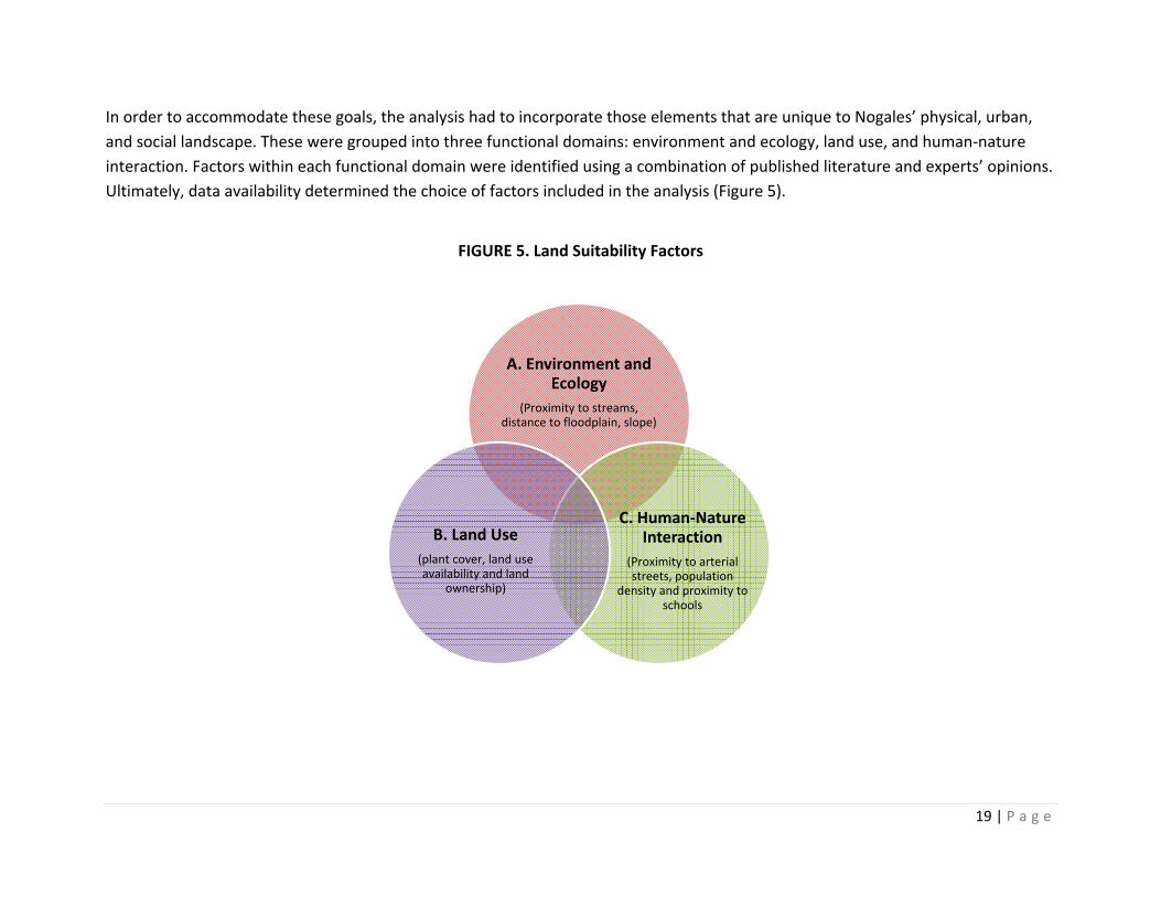
In order to accommodate these goals, the analysis had to incorporate those elements that are unique to Nogales’ physical, urban, and social landscape. These were grouped into three functional domains: environment and ecology, land use, and human‐nature interaction. Factors within each functional domain were identified using a combination of published literature and experts’ opinions. Ultimately, data availability determined the choice of factors included in the analysis (Figure 5).
FIGURE 5. Land Suitability Factors
A. Environment and Ecology
(Proximity to streams, distance to floodplain, slope)
C. Human‐Nature Interaction
(Proximity to arterial streets, population
density and proximity to schools
B. Land Use(plant cover, land use availability and land
ownership)
20 | P a g e
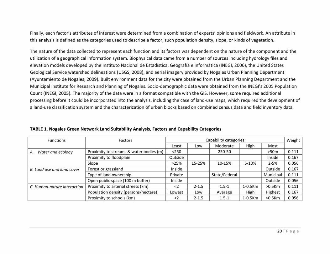
Finally, each factor’s attributes of interest were determined from a combination of experts’ opinions and fieldwork. An attribute in this analysis is defined as the categories used to describe a factor, such population density, slope, or kinds of vegetation.
The nature of the data collected to represent each function and its factors was dependent on the nature of the component and the utilization of a geographical information system. Biophysical data came from a number of sources including hydrology files and elevation models developed by the Instituto Nacional de Estadística, Geografía e Informática (INEGI, 2006), the United States Geological Service watershed delineations (USGS, 2008), and aerial imagery provided by Nogales Urban Planning Department (Ayuntamiento de Nogales, 2009). Built environment data for the city were obtained from the Urban Planning Department and the Municipal Institute for Research and Planning of Nogales. Socio‐demographic data were obtained from the INEGI’s 2005 Population Count (INEGI, 2005). The majority of the data were in a format compatible with the GIS. However, some required additional processing before it could be incorporated into the analysis, including the case of land‐use maps, which required the development of a land‐use classification system and the characterization of urban blocks based on combined census data and field inventory data.
TABLE 1. Nogales Green Network Land Suitability Analysis, Factors and Capability Categories
Functions
Factors
Capability categories Weight Least Low Moderate High Most
A. Water and ecology
Proximity to streams & water bodies (m) <250 250‐50 >50m 0.111 Proximity to floodplain Outside Inside 0.167 Slope >25% 15‐25% 10‐15% 5‐10% 2‐5% 0.056
B. Land use and land cover
Forest or grassland Inside Outside 0.167 Type of land ownership Private State/Federal Municipal 0.111 Open public space (100 m buffer) Inside Outside 0.056
C. Human‐nature interaction
Proximity to arterial streets (km) <2 2‐1.5 1.5‐1 1‐0.5Km >0.5Km 0.111 Population density (persons/hectare) Lowest Low Average High Highest 0.167 Proximity to schools (km) <2 2‐1.5 1.5‐1 1‐0.5Km >0.5Km 0.056
21 | P a g e
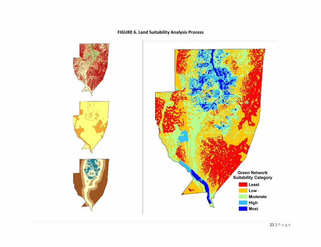
FIGURE 6. Land Suitability Analysis Process

22 | P a g e
During a land‐suitability workshop, a group of local urban‐planning experts weighted the factors. These individuals had the professional ability to provide accurate and discernible information regarding a particular network function. Each participant was asked to rank the green network function in order of importance. Factors characteristic of high capability were given a value of 1 and those with no capability a value of 0. Most factors were treated as continuous variables, with the exception of proximity to the floodplain, forest or grassland land cover, and type of land ownership, which were treated as dichotomous or categorical magnitudes.
All spatial data were imported into a raster‐based GIS system for display and analysis, where each factor is treated as an individual data layer. In a GIS land suitability analysis, the scores for the classes of each layer are the layer values. The suitability of a city site or area is determined by accumulating the scores from all the layers, and then multiplying the weight for each layer. The results of this analysis are presented in the next section.
Nodes and corridors
The resulting green network is a combination of interconnected nonlinear and linear elements lying within bounded by the Nogales Wash watershed. Nonlinear elements or nodes are composed of natural features like mountains, landforms, and promontories of varying size and shape or man‐made green spaces like public parks and gardens. Linear elements or corridors are formed by creeks or canals, associated dams and ponds, and even roads, which link the different nodes within the network. Scattered all over the Nogales Wash watershed, these nodes and corridors have functions that vary with the scale and conditions of the surrounding landscape (Figure 6).
Watershed Scale
The current urban core of Nogales is embedded almost completely within the watershed. Nodes and corridors at the edge of the watershed form a green belt that connects the city with the mountains, forests, grasslands, farmland, streams, and other elements of its outer regional space. Based on the land suitability analysis, four edge nodes and one edge corridor were identified as part of the Nogales eco‐network.
The largest of these nodes is formed by land 1,400 m above sea level in the El Pinito Mountains, located in the southeastern margin of Nogales. The highest point in this area is La Pirinola Hill, which has a maximum altitude of 1,500 m above sea level. It is a cultural
23 | P a g e
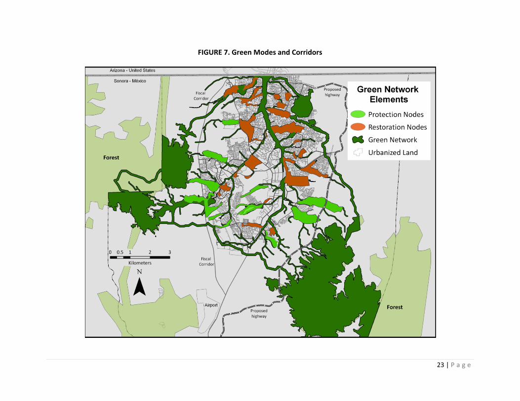
FIGURE 7. Green Modes and Corridors
24 | P a g e
landmark for the people of Nogales. This edge node is the headwaters of Arroyo Las Tinajas and Arroyo Los Capulines, two of the most important tributaries of the Arroyo Los Nogales. The total area of the node is 1,600 ha, covered mostly with oak trees, pines, and grasslands and dominated by abrupt terrain. In the northeast section, altitudes above 1,400m within the Buenos Aires hilly area form another edge node. The point of highest altitude in the node reaches 1,420 m, and it was once part of a natural preserve. Currently, the area is dominated by grasslands and some patches of oak forest. It is facing high development pressure because of a planned new highway and a real estate development, called Nogales Oriente.
Two more edge nodes are located on the west side of the watershed. One is formed by Las Avispas Mountain and the second by La Destiladera Mountain, contributing together 606 ha to the network. Both are 1,600 m above sea level at their highest points, and the terrain is dominated by oak trees and small pines. Large sections of the La Destiladera are dominated by dense patches of low desert plants, including mesquite and ocotillo. These two nodes are the headwaters of the streams forming Arroyo Chimeneas, the main tributary of Nogales Wash. Both nodes are experiencing intense pressure as the result of the development of high‐density residential areas, planned as part of the Nogales Sur planning district.
The four nodes are linked by a 200 m wide strip along the boundary of the Nogales Wash. Given their configuration, size, and natural condition, these edge nodes and corridors can be regarded as part of a land‐use planning strategy to preserve the city’s connection with nature and promote an urban form based on sustainable development principles. The Urban Development Program of the City of Nogales prohibits development in areas that are more than 1400 m above sea level and opposes urban sprawl. Edge nodes and edge corridors in the network can be regarded as a transitional zone with the function of limiting urban dispersion and bringing nature into the city.
City Scale
The analysis identified close to 15 inner nodes connected by corridors formed by streams discharging into the Nogales Wash. These inner nodes and corridors are critical elements of the eco‐network because they can provide good opportunities to develop parks and other public green spaces that can enhance recreational opportunities and improve the visual quality of the urban landscape. They can also contribute to mitigating runoff and flooding hazards by restoring pre‐development hydrological conditions, a function that can be enhanced if surrounding built‐up areas are retrofitted with green roofs, water gardens, rain‐water harvesting, and green
25 | P a g e
roads. The last would be an important component of the network as many of the main streets in the city are built within or along the channels of washes and other streams.
At the city scale, nodes can be classified as protection nodes and restoration nodes. Protection nodes are located and the fringe of the current urbanized area and occupy mainly undeveloped land along the city’s major washes, such as the Chimeneas, El Cuartel, Las Tinajas, and Canoas. Altogether protection nodes contribute 361 ha to the network. Due to their location within the expansion axes of the city, most of these nodes are surrounded by high‐density neighborhoods, industrial districts, and transitional lands. As a result, maintaining them is very important to keep nature in the city and preserve critical ecological functions of washes and wetlands. Restoration nodes at the city scale are mostly located within the urbanized area and are smaller in size than protection nodes in the urban fringe. These nodes contribute a land area of 285 ha to the whole network. Their main function within the networks is to bring back nature to areas within the city with highly disturbed or fragmented landscapes. This function is illustrated by the node located along the Chimeneas Wash in the confluence of Greco Boulevard and Calzada Tecnológico or the node located along the Celaya Wash. The first one is attached to a planned residential neighborhoods and along a major road dotted with commercial ventures. The second is embedded within an area of informal settlements that lack paved roads, basic public services, and open spaces. In both cases, waterways are occupied by urban infrastructure, riparian vegetation has been removed, riverbanks are eroded, and in some portions, watercourses have been modified.
Most inner nodes are connected or located on the floodplain of the Nogales Wash and its tributaries. Therefore, their role in controlling floods and supplying important habitat area for wildlife can be enhanced if their predevelopment functions of habitat, conduit, filter, and sink are restored. In addition, they can be adapted to become public open spaces providing residents opportunities to come in contact with nature.
Neighborhood Scale
The network components at the neighborhood level are comprised of small nodes along secondary streams or interstitial spaces within fully urbanized areas. Frequently, these spaces are occupied by publicly owned green spaces, privately owned green spaces, or remnant spaces that lack a defined use because their topography, configuration, or location rendered them unsuitable for the type of development that dominates Nogales. The analysis identified about 20 of these nodes in different part of the city. Altogether

26 | P a g e
they contribute close to 180 ha to the whole network and can be used to expand or build new public green spaces in residential areas with a limited amount of parkland and open space.
27 | P a g e
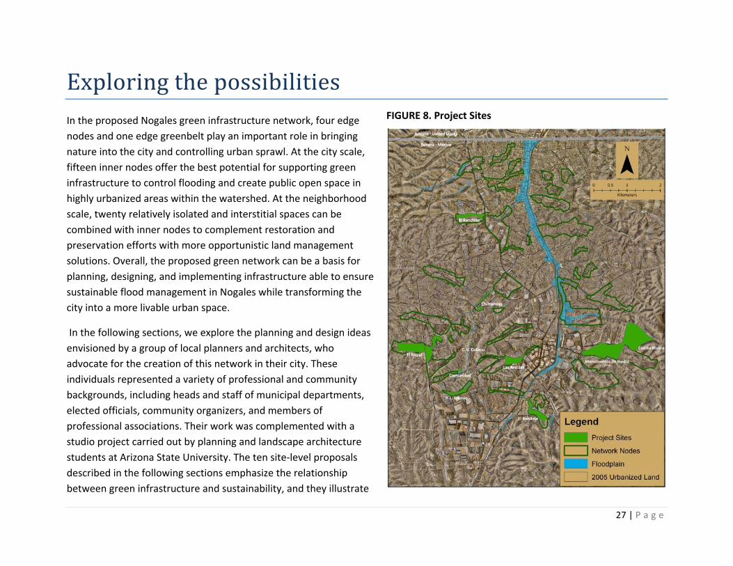
Exploring the possibilities In the proposed Nogales green infrastructure network, four edge nodes and one edge greenbelt play an important role in bringing nature into the city and controlling urban sprawl. At the city scale, fifteen inner nodes offer the best potential for supporting green infrastructure to control flooding and create public open space in highly urbanized areas within the watershed. At the neighborhood scale, twenty relatively isolated and interstitial spaces can be combined with inner nodes to complement restoration and preservation efforts with more opportunistic land management solutions. Overall, the proposed green network can be a basis for planning, designing, and implementing infrastructure able to ensure sustainable flood management in Nogales while transforming the city into a more livable urban space.
In the following sections, we explore the planning and design ideas envisioned by a group of local planners and architects, who advocate for the creation of this network in their city. These individuals represented a variety of professional and community backgrounds, including heads and staff of municipal departments, elected officials, community organizers, and members of professional associations. Their work was complemented with a studio project carried out by planning and landscape architecture students at Arizona State University. The ten site‐level proposals described in the following sections emphasize the relationship between green infrastructure and sustainability, and they illustrate
FIGURE 8. Project Sites
28 | P a g e
how selected LID tools can be used in building each of the components of the green network for Nogales.
Las Ardillas Neighborhood Park
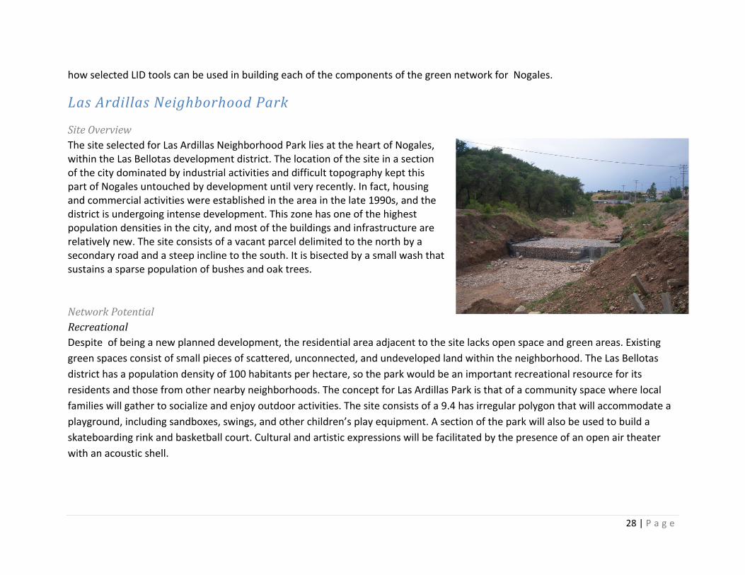
Site Overview The site selected for Las Ardillas Neighborhood Park lies at the heart of Nogales, within the Las Bellotas development district. The location of the site in a section of the city dominated by industrial activities and difficult topography kept this part of Nogales untouched by development until very recently. In fact, housing and commercial activities were established in the area in the late 1990s, and the district is undergoing intense development. This zone has one of the highest population densities in the city, and most of the buildings and infrastructure are relatively new. The site consists of a vacant parcel delimited to the north by a secondary road and a steep incline to the south. It is bisected by a small wash that sustains a sparse population of bushes and oak trees.
Network Potential Recreational Despite of being a new planned development, the residential area adjacent to the site lacks open space and green areas. Existing green spaces consist of small pieces of scattered, unconnected, and undeveloped land within the neighborhood. The Las Bellotas district has a population density of 100 habitants per hectare, so the park would be an important recreational resource for its residents and those from other nearby neighborhoods. The concept for Las Ardillas Park is that of a community space where local families will gather to socialize and enjoy outdoor activities. The site consists of a 9.4 has irregular polygon that will accommodate a playground, including sandboxes, swings, and other children’s play equipment. A section of the park will also be used to build a skateboarding rink and basketball court. Cultural and artistic expressions will be facilitated by the presence of an open air theater with an acoustic shell.
29 | P a g e
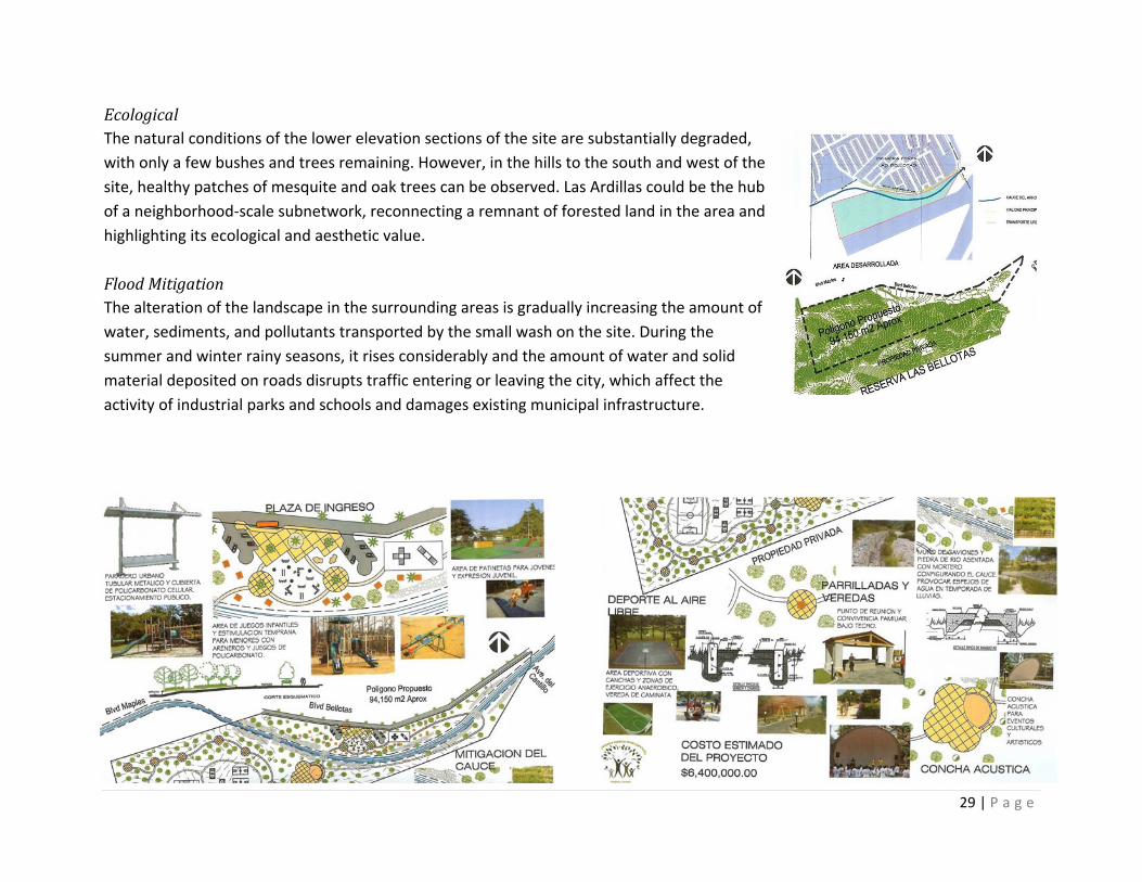
Ecological The natural conditions of the lower elevation sections of the site are substantially degraded, with only a few bushes and trees remaining. However, in the hills to the south and west of the site, healthy patches of mesquite and oak trees can be observed. Las Ardillas could be the hub of a neighborhood‐scale subnetwork, reconnecting a remnant of forested land in the area and highlighting its ecological and aesthetic value. Flood Mitigation The alteration of the landscape in the surrounding areas is gradually increasing the amount of water, sediments, and pollutants transported by the small wash on the site. During the summer and winter rainy seasons, it rises considerably and the amount of water and solid material deposited on roads disrupts traffic entering or leaving the city, which affect the activity of industrial parks and schools and damages existing municipal infrastructure.
30 | P a g e
Green Infrastructure Elements Onsite detentions through construction of an artificial pond and vegetated swales will be used in Las Ardillas to reduce storm water runoff. The streambed will be rectified and protected in those areas that show the highest levels of erosion. The use of riprap is being proposed in the streambed and gabion walls would be used to protect the stream bank and create detention ponds. Revegetation of the area would be promoted using native plants. A low‐maintenance but pleasant landscape—combining trees, shrubs, temporary water mirrors, trails, and play areas—will be the result of the reclamation of this interstitial space.
Chimeneas Linear Park
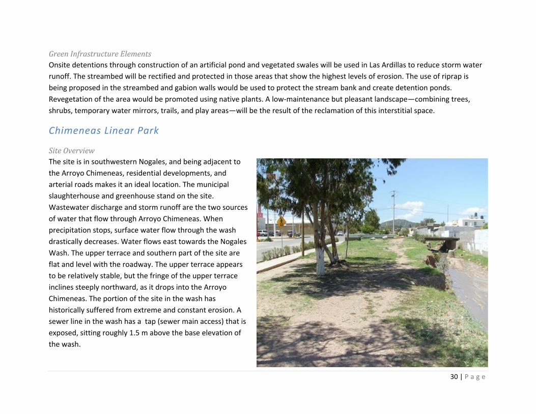
Site Overview The site is in southwestern Nogales, and being adjacent to the Arroyo Chimeneas, residential developments, and arterial roads makes it an ideal location. The municipal slaughterhouse and greenhouse stand on the site. Wastewater discharge and storm runoff are the two sources of water that flow through Arroyo Chimeneas. When precipitation stops, surface water flow through the wash drastically decreases. Water flows east towards the Nogales Wash. The upper terrace and southern part of the site are flat and level with the roadway. The upper terrace appears to be relatively stable, but the fringe of the upper terrace inclines steeply northward, as it drops into the Arroyo Chimeneas. The portion of the site in the wash has historically suffered from extreme and constant erosion. A sewer line in the wash has a tap (sewer main access) that is exposed, sitting roughly 1.5 m above the base elevation of the wash.
31 | P a g e
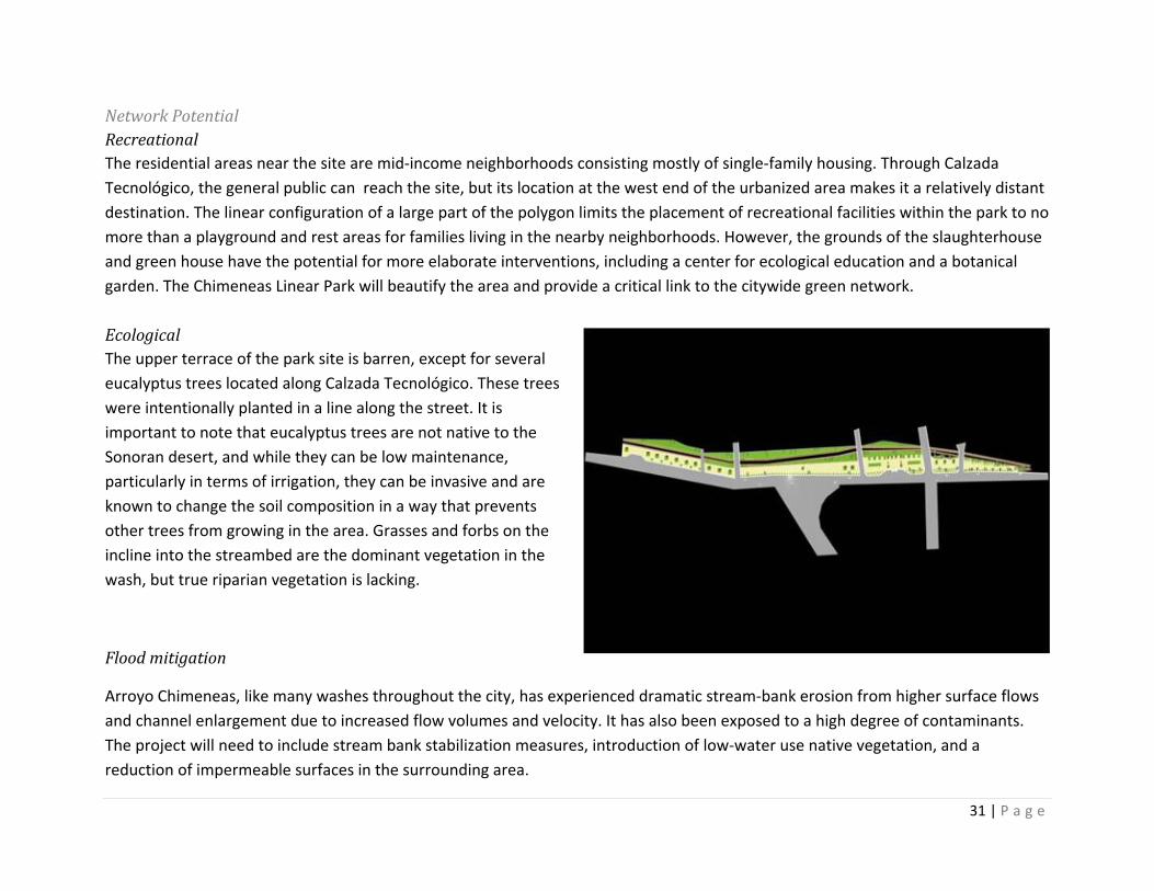
Network Potential Recreational The residential areas near the site are mid‐income neighborhoods consisting mostly of single‐family housing. Through Calzada Tecnológico, the general public can reach the site, but its location at the west end of the urbanized area makes it a relatively distant destination. The linear configuration of a large part of the polygon limits the placement of recreational facilities within the park to no more than a playground and rest areas for families living in the nearby neighborhoods. However, the grounds of the slaughterhouse and green house have the potential for more elaborate interventions, including a center for ecological education and a botanical garden. The Chimeneas Linear Park will beautify the area and provide a critical link to the citywide green network. Ecological The upper terrace of the park site is barren, except for several eucalyptus trees located along Calzada Tecnológico. These trees were intentionally planted in a line along the street. It is important to note that eucalyptus trees are not native to the Sonoran desert, and while they can be low maintenance, particularly in terms of irrigation, they can be invasive and are known to change the soil composition in a way that prevents other trees from growing in the area. Grasses and forbs on the incline into the streambed are the dominant vegetation in the wash, but true riparian vegetation is lacking.
Flood mitigation
Arroyo Chimeneas, like many washes throughout the city, has experienced dramatic stream‐bank erosion from higher surface flows and channel enlargement due to increased flow volumes and velocity. It has also been exposed to a high degree of contaminants. The project will need to include stream bank stabilization measures, introduction of low‐water use native vegetation, and a reduction of impermeable surfaces in the surrounding area.
32 | P a g e
Green Infrastructure Elements The site of the park is an irregular polygon of approximately 5 ha, including a 630 m long strip parallel to the Arroyo Chimeneas. Access streets to Real del Arco and other residential areas split the parcel into three sections. The location of the site adjacent to Arroyo Chimeneas provides the opportunity to implement flood control management using green infrastructure solutions. The concept comprises ecological elements, such as all native vegetation, ramadas, sculptures that can double as public art and children’s play equipment, grass‐stone pavers, natural stone benches, and solar lighting. Arroyo Chimeneas would be stabilized with boulder riprap, which is an ecologically sensitive technique that uses natural materials, leads to improved water quality by capturing sediments, prevents soil erosion, and allows for vegetation growth, all of which improve the natural habitat. The land is currently owned by the City of Nogales, which can dramatically reduce implementation costs.
El Ranchito de los Alisos
Site Overview The selected site is an elongated and irregular polygon covering about 19.6 ha, lying completely within the Canoas Wash. It is surrounded by high‐density residential areas to the north (Canoas and Puesta del Sol) and to the east (Colonia Esperanza). It is close to a middle school, a cement plant, and a power generation station. The site has very good accessibility, as it is located near major roads and public transit routes.
Network Potential Recreational Until the 1990s, the site was a traditional picnic and recreational area for local families. Illegal disposal of domestic waste and construction debris from adjacent residential developments, as well as discharge of residue from the cement plant, reduced the appeal of the site for visitors. The creation of the park will bring back and enhance the amenity value that this area has traditionally provided to the people of Nogales. Served populations will include primarily residents of nearby
33 | P a g e
neighborhoods, as well as workers and shoppers of the area’s businesses and students attending neighborhood schools.
Ecological Despite its location near major roads and high‐density developments, the site has maintained healthy patches of mesquite and oak trees. The stream bank of Canoas Wash is subject to extraction of sand, gravel, and other material used for construction activities. Talus and terraces along the wash are degraded due to the illegal dumping of trash and other materials by residents of nearby neighborhoods and by a cement plant located at the east end of the creek.
Flood mitigation Canoas Wash is short stream, yet it is the conduit for an important volume of runoff and sediments from mountain tops to the west of Nogales. During the monsoon season, water runoffs discharge directly on Calle 5 de Febrero producing damaging property and infrastructure and creating hazards for local residents and drivers. It is common that runoffs leave the creek carrying substantial amounts of sand, organic material, and waste that accumulate on Calle 5 de Febrero or infiltrate sewer lines producing raw wastewater overflows.
Green Infrastructure Elements A primary goal of the project will be to create a streamside buffer to protect the areas adjacent to the wash. When functioning properly, the buffer will serve as a vegetated protective area between the wash and human activity. A healthy vegetated buffer will help to improve in‐stream water quality by filtering and slowing pollution runoff, preventing soil erosion, providing upland habitat, contributing essential nutrients to the food chain, and providing woody debris for in‐stream habitat and shade cover. Buffers will also help absorb floodwaters to protect human life and property. The development of amenity value will exploit the rural character and the traditional use of the site as picnic area. The families living in the area expressed an interest in participating in the operation of small enterprises catering to potential visitors and offering horseback riding, regional food, and camping services.
34 | P a g e
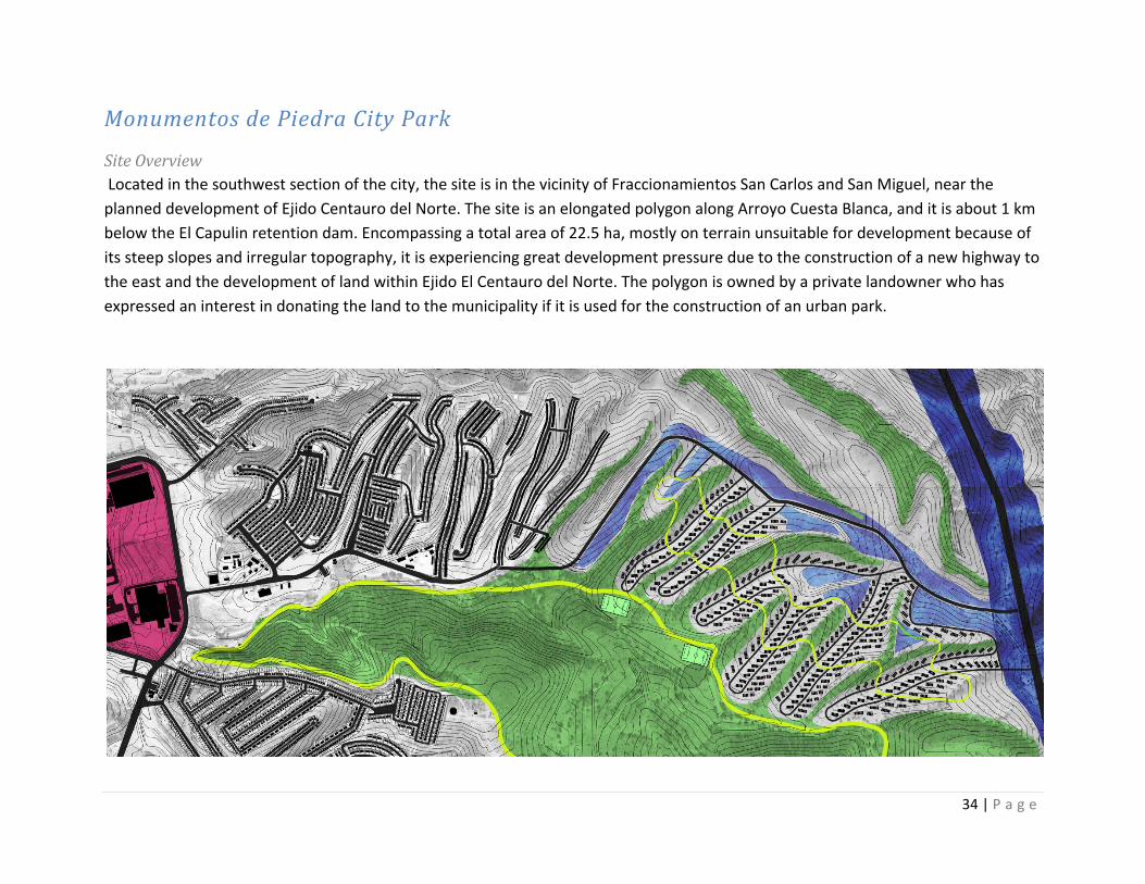
Monumentos de Piedra City Park
Site Overview Located in the southwest section of the city, the site is in the vicinity of Fraccionamientos San Carlos and San Miguel, near the planned development of Ejido Centauro del Norte. The site is an elongated polygon along Arroyo Cuesta Blanca, and it is about 1 km below the El Capulin retention dam. Encompassing a total area of 22.5 ha, mostly on terrain unsuitable for development because of its steep slopes and irregular topography, it is experiencing great development pressure due to the construction of a new highway to the east and the development of land within Ejido El Centauro del Norte. The polygon is owned by a private landowner who has expressed an interest in donating the land to the municipality if it is used for the construction of an urban park.
35 | P a g e
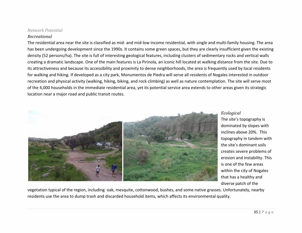
Network Potential Recreational The residential area near the site is classified as mid‐ and mid‐low income residential, with single and multi‐family housing. The area has been undergoing development since the 1990s. It contains some green spaces, but they are clearly insufficient given the existing density (52 persons/ha). The site is full of interesting geological features, including clusters of sedimentary rocks and vertical walls creating a dramatic landscape. One of the main features is La Pirinola, an iconic hill located at walking distance from the site. Due to its attractiveness and because its accessibility and proximity to dense neighborhoods, the area is frequently used by local residents for walking and hiking. If developed as a city park, Monumentos de Piedra will serve all residents of Nogales interested in outdoor recreation and physical activity (walking, hiking, biking, and rock climbing) as well as nature contemplation. The site will serve most of the 4,000 households in the immediate residential area, yet its potential service area extends to other areas given its strategic location near a major road and public transit routes.
Ecological The site’s topography is dominated by slopes with inclines above 20%. This topography in tandem with the site’s dominant soils creates severe problems of erosion and instability. This is one of the few areas within the city of Nogales that has a healthy and diverse patch of the
vegetation typical of the region, including oak, mesquite, cottonwood, bushes, and some native grasses. Unfortunately, nearby residents use the area to dump trash and discarded household items, which affects its environmental quality.
36 | P a g e
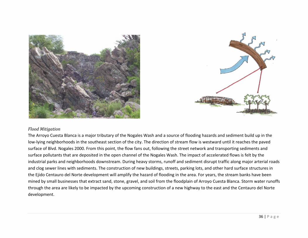
Flood Mitigation The Arroyo Cuesta Blanca is a major tributary of the Nogales Wash and a source of flooding hazards and sediment build up in the low‐lying neighborhoods in the southeast section of the city. The direction of stream flow is westward until it reaches the paved surface of Blvd. Nogales 2000. From this point, the flow fans out, following the street network and transporting sediments and surface pollutants that are deposited in the open channel of the Nogales Wash. The impact of accelerated flows is felt by the industrial parks and neighborhoods downstream. During heavy storms, runoff and sediment disrupt traffic along major arterial roads and clog sewer lines with sediments. The construction of new buildings, streets, parking lots, and other hard surface structures in the Ejido Centauro del Norte development will amplify the hazard of flooding in the area. For years, the stream banks have been mined by small businesses that extract sand, stone, gravel, and soil from the floodplain of Arroyo Cuesta Blanca. Storm water runoffs through the area are likely to be impacted by the upcoming construction of a new highway to the east and the Centauro del Norte development.
37 | P a g e
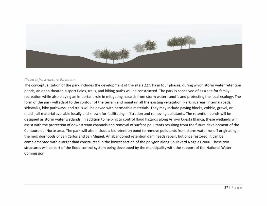
Green Infrastructure Elements The conceptualization of the park includes the development of the site’s 22.5 ha in four phases, during which storm water retention ponds, an open theater, a sport fields, trails, and biking paths will be constructed. The park is conceived of as a site for family recreation while also playing an important role in mitigating hazards from storm water runoffs and protecting the local ecology. The form of the park will adapt to the contour of the terrain and maintain all the existing vegetation. Parking areas, internal roads, sidewalks, bike pathways, and trails will be paved with permeable materials. They may include paving blocks, cobble, gravel, or mulch, all material available locally and known for facilitating infiltration and removing pollutants. The retention ponds will be designed as storm water wetlands. In addition to helping to control flood hazards along Arroyo Cuesta Blanca, these wetlands will assist with the protection of downstream channels and removal of surface pollutants resulting from the future development of the Centauro del Norte area. The park will also include a bioretention pond to remove pollutants from storm water runoff originating in the neighborhoods of San Carlos and San Miguel. An abandoned retention dam needs repair, but once restored, it can be complemented with a larger dam constructed in the lowest section of the polygon along Boulevard Nogales 2000. These two structures will be part of the flood control system being developed by the municipality with the support of the National Water Commission.
38 | P a g e
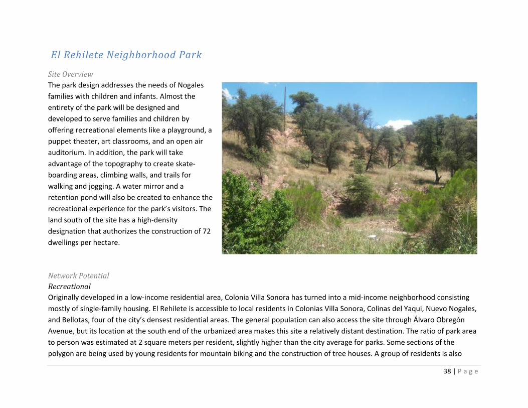
El Rehilete Neighborhood Park
Site Overview The park design addresses the needs of Nogales families with children and infants. Almost the entirety of the park will be designed and developed to serve families and children by offering recreational elements like a playground, a puppet theater, art classrooms, and an open air auditorium. In addition, the park will take advantage of the topography to create skate‐boarding areas, climbing walls, and trails for walking and jogging. A water mirror and a retention pond will also be created to enhance the recreational experience for the park’s visitors. The land south of the site has a high‐density designation that authorizes the construction of 72 dwellings per hectare. Network Potential Recreational Originally developed in a low‐income residential area, Colonia Villa Sonora has turned into a mid‐income neighborhood consisting mostly of single‐family housing. El Rehilete is accessible to local residents in Colonias Villa Sonora, Colinas del Yaqui, Nuevo Nogales, and Bellotas, four of the city’s densest residential areas. The general population can also access the site through Álvaro Obregón Avenue, but its location at the south end of the urbanized area makes this site a relatively distant destination. The ratio of park area to person was estimated at 2 square meters per resident, slightly higher than the city average for parks. Some sections of the polygon are being used by young residents for mountain biking and the construction of tree houses. A group of residents is also
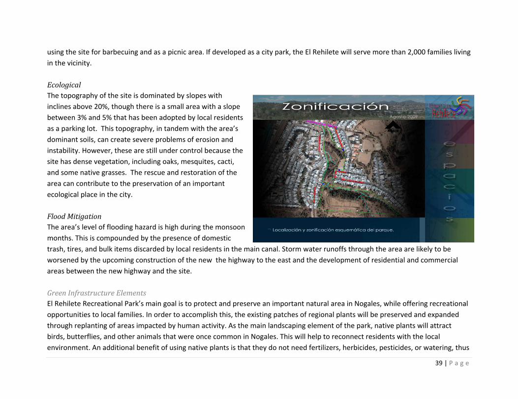
39 | P a g e
using the site for barbecuing and as a picnic area. If developed as a city park, the El Rehilete will serve more than 2,000 families living in the vicinity. Ecological The topography of the site is dominated by slopes with inclines above 20%, though there is a small area with a slope between 3% and 5% that has been adopted by local residents as a parking lot. This topography, in tandem with the area’s dominant soils, can create severe problems of erosion and instability. However, these are still under control because the site has dense vegetation, including oaks, mesquites, cacti, and some native grasses. The rescue and restoration of the area can contribute to the preservation of an important ecological place in the city. Flood Mitigation The area’s level of flooding hazard is high during the monsoon months. This is compounded by the presence of domestic trash, tires, and bulk items discarded by local residents in the main canal. Storm water runoffs through the area are likely to be worsened by the upcoming construction of the new the highway to the east and the development of residential and commercial areas between the new highway and the site. Green Infrastructure Elements El Rehilete Recreational Park’s main goal is to protect and preserve an important natural area in Nogales, while offering recreational opportunities to local families. In order to accomplish this, the existing patches of regional plants will be preserved and expanded through replanting of areas impacted by human activity. As the main landscaping element of the park, native plants will attract birds, butterflies, and other animals that were once common in Nogales. This will help to reconnect residents with the local environment. An additional benefit of using native plants is that they do not need fertilizers, herbicides, pesticides, or watering, thus
40 | P a g e
benefiting both the environment and the city’s strained finances. The retention pond planned in the south section of the park will help to reduce peak flows along the arroyo, remove pollutants, and promote runoff infiltration. The retention pond will provide valuable habitat space for local fauna, enhancing the recreational opportunities of visitors to the park (for example, bird watching).
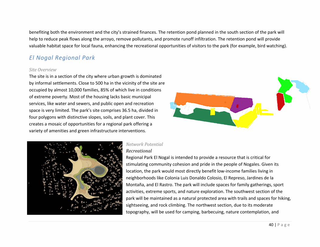
El Nogal Regional Park
Site Overview The site is in a section of the city where urban growth is dominated by informal settlements. Close to 500 ha in the vicinity of the site are occupied by almost 10,000 families, 85% of which live in conditions of extreme poverty. Most of the housing lacks basic municipal services, like water and sewers, and public open and recreation space is very limited. The park’s site comprises 36.5 ha, divided in four polygons with distinctive slopes, soils, and plant cover. This creates a mosaic of opportunities for a regional park offering a variety of amenities and green infrastructure interventions.
Network Potential Recreational Regional Park El Nogal is intended to provide a resource that is critical for stimulating community cohesion and pride in the people of Nogales. Given its location, the park would most directly benefit low‐income families living in neighborhoods like Colonia Luis Donaldo Colosio, El Represo, Jardines de la Montaña, and El Rastro. The park will include spaces for family gatherings, sport activities, extreme sports, and nature exploration. The southwest section of the park will be maintained as a natural protected area with trails and spaces for hiking, sightseeing, and rock climbing. The northwest section, due to its moderate topography, will be used for camping, barbecuing, nature contemplation, and
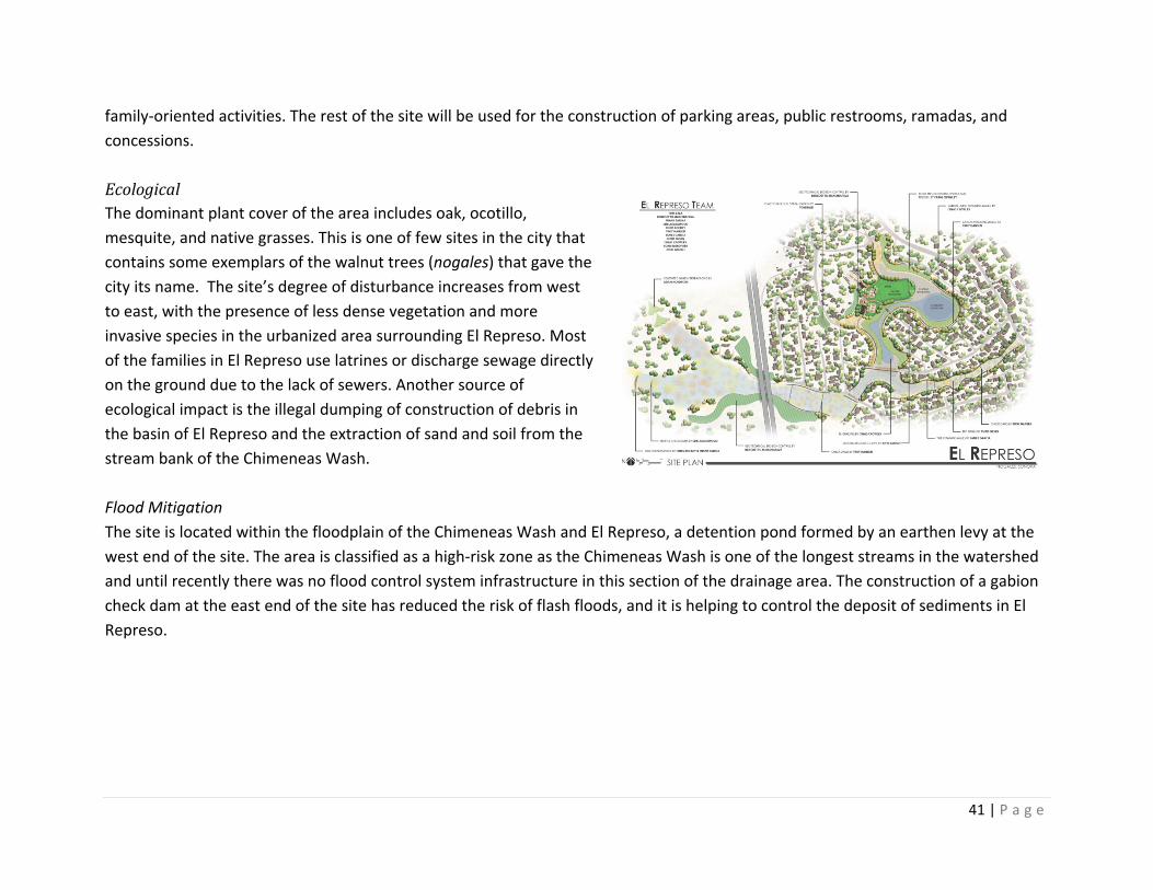
41 | P a g e
family‐oriented activities. The rest of the site will be used for the construction of parking areas, public restrooms, ramadas, and concessions. Ecological The dominant plant cover of the area includes oak, ocotillo, mesquite, and native grasses. This is one of few sites in the city that contains some exemplars of the walnut trees (nogales) that gave the city its name. The site’s degree of disturbance increases from west to east, with the presence of less dense vegetation and more invasive species in the urbanized area surrounding El Represo. Most of the families in El Represo use latrines or discharge sewage directly on the ground due to the lack of sewers. Another source of ecological impact is the illegal dumping of construction of debris in the basin of El Represo and the extraction of sand and soil from the stream bank of the Chimeneas Wash. Flood Mitigation The site is located within the floodplain of the Chimeneas Wash and El Represo, a detention pond formed by an earthen levy at the west end of the site. The area is classified as a high‐risk zone as the Chimeneas Wash is one of the longest streams in the watershed and until recently there was no flood control system infrastructure in this section of the drainage area. The construction of a gabion check dam at the east end of the site has reduced the risk of flash floods, and it is helping to control the deposit of sediments in El Represo.
42 | P a g e
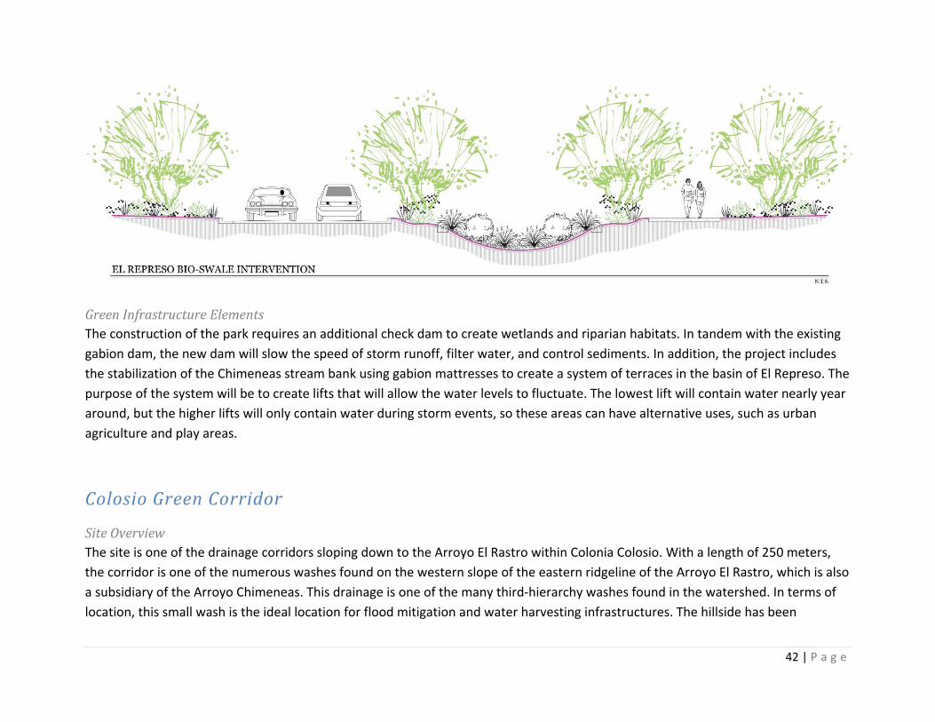
Green Infrastructure Elements The construction of the park requires an additional check dam to create wetlands and riparian habitats. In tandem with the existing gabion dam, the new dam will slow the speed of storm runoff, filter water, and control sediments. In addition, the project includes the stabilization of the Chimeneas stream bank using gabion mattresses to create a system of terraces in the basin of El Represo. The purpose of the system will be to create lifts that will allow the water levels to fluctuate. The lowest lift will contain water nearly year around, but the higher lifts will only contain water during storm events, so these areas can have alternative uses, such as urban agriculture and play areas.
Colosio Green Corridor
Site Overview The site is one of the drainage corridors sloping down to the Arroyo El Rastro within Colonia Colosio. With a length of 250 meters, the corridor is one of the numerous washes found on the western slope of the eastern ridgeline of the Arroyo El Rastro, which is also a subsidiary of the Arroyo Chimeneas. This drainage is one of the many third‐hierarchy washes found in the watershed. In terms of location, this small wash is the ideal location for flood mitigation and water harvesting infrastructures. The hillside has been
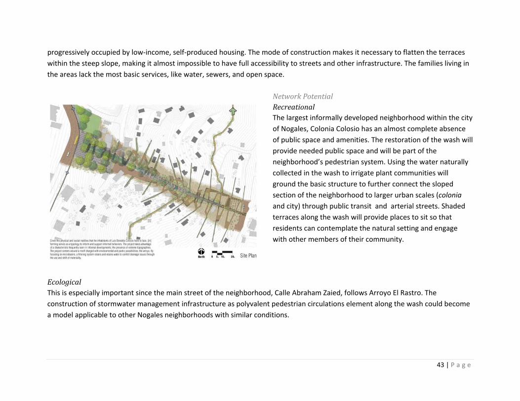
43 | P a g e
progressively occupied by low‐income, self‐produced housing. The mode of construction makes it necessary to flatten the terraces within the steep slope, making it almost impossible to have full accessibility to streets and other infrastructure. The families living in the areas lack the most basic services, like water, sewers, and open space.
Network Potential Recreational The largest informally developed neighborhood within the city of Nogales, Colonia Colosio has an almost complete absence of public space and amenities. The restoration of the wash will provide needed public space and will be part of the neighborhood’s pedestrian system. Using the water naturally collected in the wash to irrigate plant communities will ground the basic structure to further connect the sloped section of the neighborhood to larger urban scales (colonia and city) through public transit and arterial streets. Shaded terraces along the wash will provide places to sit so that residents can contemplate the natural setting and engage with other members of their community.
Ecological This is especially important since the main street of the neighborhood, Calle Abraham Zaied, follows Arroyo El Rastro. The construction of stormwater management infrastructure as polyvalent pedestrian circulations element along the wash could become a model applicable to other Nogales neighborhoods with similar conditions.
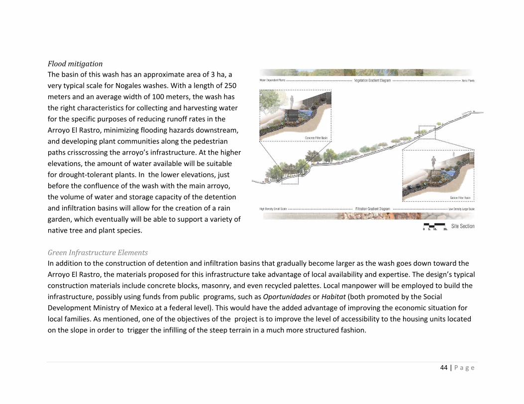
44 | P a g e
Flood mitigation The basin of this wash has an approximate area of 3 ha, a very typical scale for Nogales washes. With a length of 250 meters and an average width of 100 meters, the wash has the right characteristics for collecting and harvesting water for the specific purposes of reducing runoff rates in the Arroyo El Rastro, minimizing flooding hazards downstream, and developing plant communities along the pedestrian paths crisscrossing the arroyo’s infrastructure. At the higher elevations, the amount of water available will be suitable for drought‐tolerant plants. In the lower elevations, just before the confluence of the wash with the main arroyo, the volume of water and storage capacity of the detention and infiltration basins will allow for the creation of a rain garden, which eventually will be able to support a variety of native tree and plant species. Green Infrastructure Elements In addition to the construction of detention and infiltration basins that gradually become larger as the wash goes down toward the Arroyo El Rastro, the materials proposed for this infrastructure take advantage of local availability and expertise. The design’s typical construction materials include concrete blocks, masonry, and even recycled palettes. Local manpower will be employed to build the infrastructure, possibly using funds from public programs, such as Oportunidades or Habitat (both promoted by the Social Development Ministry of Mexico at a federal level). This would have the added advantage of improving the economic situation for local families. As mentioned, one of the objectives of the project is to improve the level of accessibility to the housing units located on the slope in order to trigger the infilling of the steep terrain in a much more structured fashion.
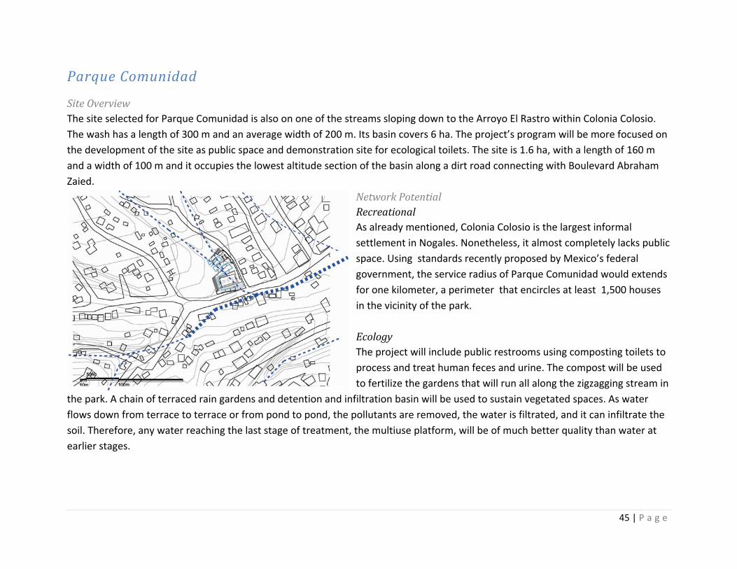
45 | P a g e
Parque Comunidad
Site Overview The site selected for Parque Comunidad is also on one of the streams sloping down to the Arroyo El Rastro within Colonia Colosio. The wash has a length of 300 m and an average width of 200 m. Its basin covers 6 ha. The project’s program will be more focused on the development of the site as public space and demonstration site for ecological toilets. The site is 1.6 ha, with a length of 160 m and a width of 100 m and it occupies the lowest altitude section of the basin along a dirt road connecting with Boulevard Abraham Zaied.
Network Potential Recreational As already mentioned, Colonia Colosio is the largest informal settlement in Nogales. Nonetheless, it almost completely lacks public space. Using standards recently proposed by Mexico’s federal government, the service radius of Parque Comunidad would extends for one kilometer, a perimeter that encircles at least 1,500 houses in the vicinity of the park. Ecology The project will include public restrooms using composting toilets to process and treat human feces and urine. The compost will be used to fertilize the gardens that will run all along the zigzagging stream in
the park. A chain of terraced rain gardens and detention and infiltration basin will be used to sustain vegetated spaces. As water flows down from terrace to terrace or from pond to pond, the pollutants are removed, the water is filtrated, and it can infiltrate the soil. Therefore, any water reaching the last stage of treatment, the multiuse platform, will be of much better quality than water at earlier stages.
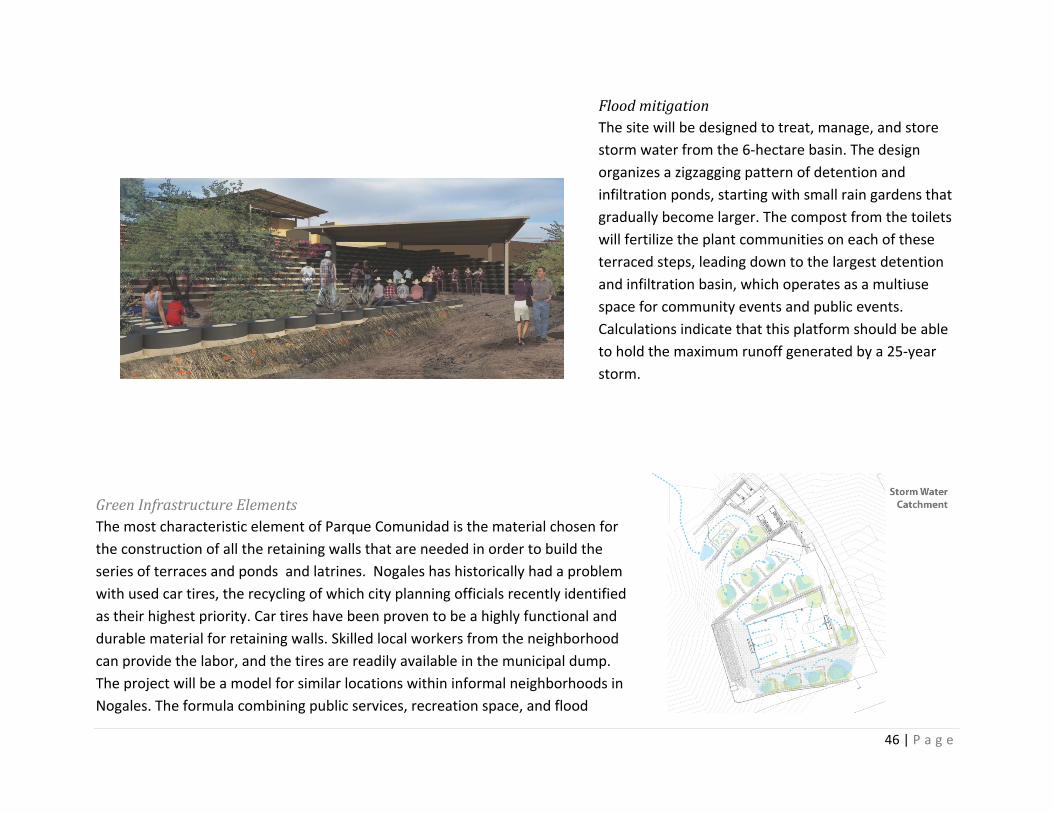
46 | P a g e
Flood mitigation The site will be designed to treat, manage, and store storm water from the 6‐hectare basin. The design organizes a zigzagging pattern of detention and infiltration ponds, starting with small rain gardens that gradually become larger. The compost from the toilets will fertilize the plant communities on each of these terraced steps, leading down to the largest detention and infiltration basin, which operates as a multiuse space for community events and public events. Calculations indicate that this platform should be able to hold the maximum runoff generated by a 25‐year storm.
Green Infrastructure Elements The most characteristic element of Parque Comunidad is the material chosen for the construction of all the retaining walls that are needed in order to build the series of terraces and ponds and latrines. Nogales has historically had a problem with used car tires, the recycling of which city planning officials recently identified as their highest priority. Car tires have been proven to be a highly functional and durable material for retaining walls. Skilled local workers from the neighborhood can provide the labor, and the tires are readily available in the municipal dump. The project will be a model for similar locations within informal neighborhoods in Nogales. The formula combining public services, recreation space, and flood
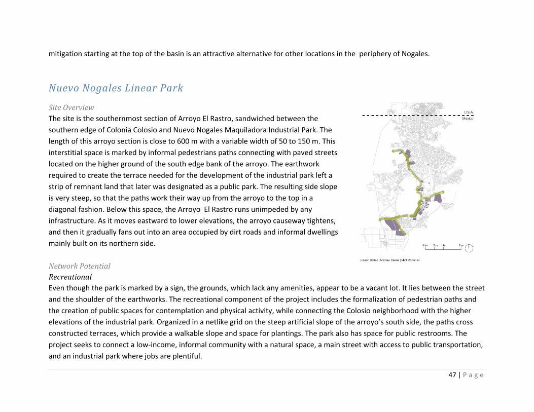
47 | P a g e
mitigation starting at the top of the basin is an attractive alternative for other locations in the periphery of Nogales.
Nuevo Nogales Linear Park
Site Overview The site is the southernmost section of Arroyo El Rastro, sandwiched between the southern edge of Colonia Colosio and Nuevo Nogales Maquiladora Industrial Park. The length of this arroyo section is close to 600 m with a variable width of 50 to 150 m. This interstitial space is marked by informal pedestrians paths connecting with paved streets located on the higher ground of the south edge bank of the arroyo. The earthwork required to create the terrace needed for the development of the industrial park left a strip of remnant land that later was designated as a public park. The resulting side slope is very steep, so that the paths work their way up from the arroyo to the top in a diagonal fashion. Below this space, the Arroyo El Rastro runs unimpeded by any infrastructure. As it moves eastward to lower elevations, the arroyo causeway tightens, and then it gradually fans out into an area occupied by dirt roads and informal dwellings mainly built on its northern side. Network Potential Recreational Even though the park is marked by a sign, the grounds, which lack any amenities, appear to be a vacant lot. It lies between the street and the shoulder of the earthworks. The recreational component of the project includes the formalization of pedestrian paths and the creation of public spaces for contemplation and physical activity, while connecting the Colosio neighborhood with the higher elevations of the industrial park. Organized in a netlike grid on the steep artificial slope of the arroyo’s south side, the paths cross constructed terraces, which provide a walkable slope and space for plantings. The park also has space for public restrooms. The project seeks to connect a low‐income, informal community with a natural space, a main street with access to public transportation, and an industrial park where jobs are plentiful.
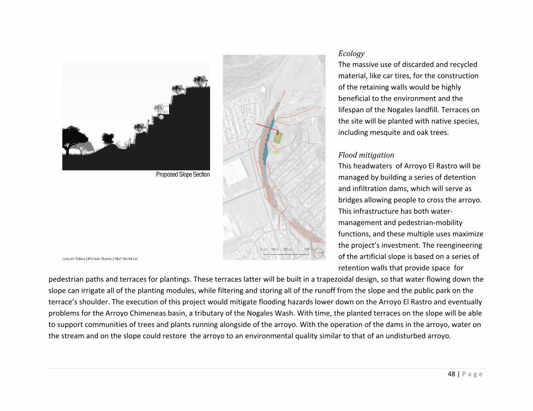
48 | P a g e
Ecology The massive use of discarded and recycled material, like car tires, for the construction of the retaining walls would be highly beneficial to the environment and the lifespan of the Nogales landfill. Terraces on the site will be planted with native species, including mesquite and oak trees. Flood mitigation This headwaters of Arroyo El Rastro will be managed by building a series of detention and infiltration dams, which will serve as bridges allowing people to cross the arroyo. This infrastructure has both water‐management and pedestrian‐mobility functions, and these multiple uses maximize the project’s investment. The reengineering of the artificial slope is based on a series of retention walls that provide space for
pedestrian paths and terraces for plantings. These terraces latter will be built in a trapezoidal design, so that water flowing down the slope can irrigate all of the planting modules, while filtering and storing all of the runoff from the slope and the public park on the terrace’s shoulder. The execution of this project would mitigate flooding hazards lower down on the Arroyo El Rastro and eventually problems for the Arroyo Chimeneas basin, a tributary of the Nogales Wash. With time, the planted terraces on the slope will be able to support communities of trees and plants running alongside of the arroyo. With the operation of the dams in the arroyo, water on the stream and on the slope could restore the arroyo to an environmental quality similar to that of an undisturbed arroyo.
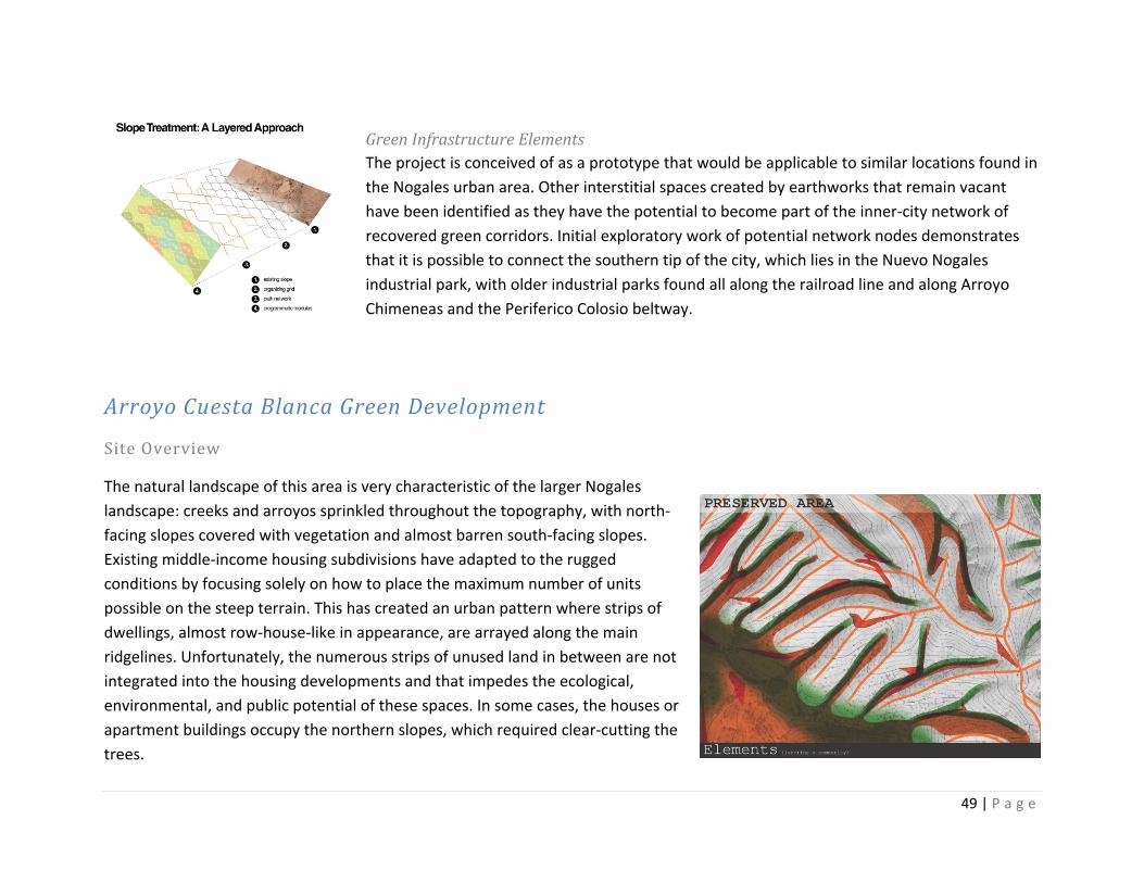
49 | P a g e
Green Infrastructure Elements The project is conceived of as a prototype that would be applicable to similar locations found in the Nogales urban area. Other interstitial spaces created by earthworks that remain vacant have been identified as they have the potential to become part of the inner‐city network of recovered green corridors. Initial exploratory work of potential network nodes demonstrates that it is possible to connect the southern tip of the city, which lies in the Nuevo Nogales industrial park, with older industrial parks found all along the railroad line and along Arroyo Chimeneas and the Periferico Colosio beltway.
Arroyo Cuesta Blanca Green Development
Site Overview
The natural landscape of this area is very characteristic of the larger Nogales landscape: creeks and arroyos sprinkled throughout the topography, with north‐facing slopes covered with vegetation and almost barren south‐facing slopes. Existing middle‐income housing subdivisions have adapted to the rugged conditions by focusing solely on how to place the maximum number of units possible on the steep terrain. This has created an urban pattern where strips of dwellings, almost row‐house‐like in appearance, are arrayed along the main ridgelines. Unfortunately, the numerous strips of unused land in between are not integrated into the housing developments and that impedes the ecological, environmental, and public potential of these spaces. In some cases, the houses or apartment buildings occupy the northern slopes, which required clear‐cutting the trees.
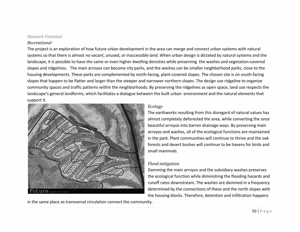
50 | P a g e
Network Potential Recreational The project is an exploration of how future urban development in the area can merge and connect urban systems with natural systems so that there is almost no vacant, unused, or inaccessible land. When urban design is dictated by natural systems and the landscape, it is possible to have the same or even higher dwelling densities while preserving the washes and vegetation‐covered slopes and ridgelines. The main arroyos can become city parks, and the washes can be smaller neighborhood parks, close to the housing developments. These parks are complemented by north‐facing, plant‐covered slopes. The chosen site is on south‐facing slopes that happen to be flatter and larger than the steeper and narrower northern slopes. The design use ridgeline to organize community spaces and traffic patterns within the neighborhoods. By preserving the ridgelines as open space, land use respects the landscape’s general landforms, which facilitates a dialogue between the built urban environment and the natural elements that support it.
Ecology The earthworks resulting from this disregard of natural values has almost completely deforested the area, while converting the once beautiful arroyos into barren drainage ways. By preserving main arroyos and washes, all of the ecological functions are maintained in the park. Plant communities will continue to thrive and the oak forests and desert bushes will continue to be havens for birds and small mammals. Flood mitigation Damming the main arroyos and the subsidiary washes preserves the ecological function while diminishing the flooding hazards and runoff rates downstream. The washes are dammed in a frequency determined by the connections of these and the north slopes with the housing blocks. Therefore, detention and infiltration happens
in the same place as transversal circulation connect the community.
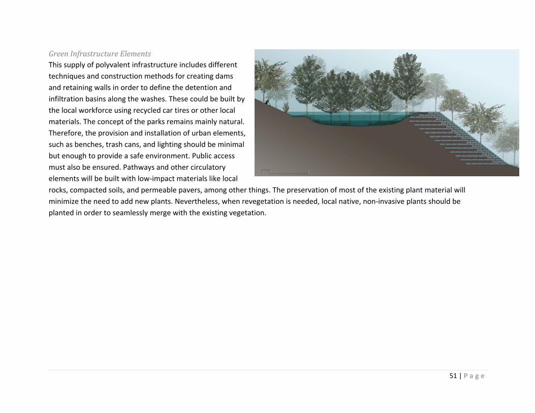
51 | P a g e
Green Infrastructure Elements This supply of polyvalent infrastructure includes different techniques and construction methods for creating dams and retaining walls in order to define the detention and infiltration basins along the washes. These could be built by the local workforce using recycled car tires or other local materials. The concept of the parks remains mainly natural. Therefore, the provision and installation of urban elements, such as benches, trash cans, and lighting should be minimal but enough to provide a safe environment. Public access must also be ensured. Pathways and other circulatory elements will be built with low‐impact materials like local rocks, compacted soils, and permeable pavers, among other things. The preservation of most of the existing plant material will minimize the need to add new plants. Nevertheless, when revegetation is needed, local native, non‐invasive plants should be planted in order to seamlessly merge with the existing vegetation.

52 | P a g e
Implementation
The concepts presented in this report highlight the potential of the City of Nogales, Sonora, to become one of the greenest cities along the Mexican border. Green infrastructure solutions embedded in an urban eco‐network match the economic benefits of traditional storm‐water management infrastructure, yet they provide the additional environmental and social benefits that can accrue from the utilization of nature‐based urban technologies. Studies have shown green infrastructure solutions to be sound public investments, particularly for cities seeking innovative ways to undertake cost‐effective urban development programs and promote economic competitiveness and a better quality of life.
Still, the incorporation of green infrastructure solutions into Nogales’s development strategies will be a complex undertaking requiring a well‐structured implementation framework that includes basic action steps (fig. 8).
FIGURE 8: Implementation program
•Evaluate needs, opportunities, and constrains
•Develop local capacity•Engage community leaders•Formulate a strategic plan with input from all social sectors
•Socialize knowledge and concepts
Forge a shared vision
•Realign developers' incentives•Promote partnerships with local media, professional associations, and bussiness organizations
•Update municipal codes•Reward local organizations and bussiness that contribute to the vision
Create incentives•Rethink citywide open space•Reallocate municipal public work funds
•Coordinate municipal programs•Develop external partneships•Coordinate state and federal programs
Mobilize existing resources
•Creata a "land bank"•Leverage state and federal resources
•Leverage international and binational programs
•Promote an "adopt a park" program
Develop new resources
53 | P a g e
The first step of this program would be to forge a shared vision of a sustainable city, in which growth is transformed into development by balancing economic expansion with quality of life and environmental stewardship goals. This vision must rely on green infrastructure solutions as the most cost‐effective way to address the city’s chronic deficits in storm water infrastructure, open space provision, and environmental protection. The creation of the Municipal Institute for Research and Planning, the update of the Nogales General Plan, and the continuation of the multiple partnerships the city has developed with U.S. and Mexican universities has advanced the forging of this vision. The completion of this study and the sustainable planning workshops conducted by Arizona State University in collaboration with the El Colegio de la Frontera Norte in the summers of 2009 and 2010 have also contributed to the vision. Nonetheless, more needs to be done, including the formulation of a strategic plan based on input from all social sectors and the socialization of information and knowledge about the benefits of a green network for Nogales. The overall goal of these activities would be to create consensus about the city’s future and the role that citizen, government, business owners, and community organizations should play in achieving a shared vision.
The second step consists of a series of actions intended to modify the behavior of individuals, institutions, and organizations in Nogales. It would be naïve to expect that residents and organization would spontaneously adopt new practices regarding, for instance, occupation of streams, extraction of natural materials, disposal of waste, protection of forests, construction methods, or land modification. Therefore, for green infrastructure solutions to be accepted and practiced by the community, some changes in the regulatory and institutional systems are needed to create adequate incentives for modifying collective behaviors. Some of these needed reforms are the realignment of developers’ incentives for adopting green infrastructure, which can be brought about through changes to the construction code and the creation of social demand for green solutions to urban problems. Perhaps the most important policy enhancement is the incorporation of open‐space design guidelines into the city’s municipal code. Currently, no design standard for open space or parks exists within that code. Some minimum standards should include incorporation of flood‐control design enhancement for every site, particularly those located along washes. In particular, the new design guidelines should promote the following:
Public spaces—including parks, play areas, community gardens, and plazas—should be designed to include locally available native vegetation to promote and maintain the ecological balance of the area.
Urban furniture within parks should employ recycled or reusable materials as much as possible to encourage sustainability.
Sites adjacent to or along washes should include stabilization techniques to improve citywide flood control.
54 | P a g e
Large engineered storm water facilities should be aesthetically pleasing and integrated into the open space system, and they should not be designed in ways that limit recreational opportunities.
Storm water ponds should incorporate natural elements, such as varied topography and native plants, which can enhance the site’s recreational opportunities and improve water quality.
In neighborhoods that have only the smallest of parks or urban gardens, residents should be compensated by giving them access to communal spaces that meet area needs.
An open space area should have clearly defined boundaries and should be physically linked to the residential areas it serves. This will imbue the residents with a sense of ownership of the open‐space area.
Walking paths and trails should be provided within the open spaces to encourage residents to walk through communal areas on their way to public transportation routes or nearby commercial locales. This will develop a greater sense of community belonging and territorial sense connection
Once the vision and institutional changes are established, local leadership should move to step three of the implementation program. This step is intended to optimize existing resources by realigning governmental programs and social initiatives with the new priorities and practices advanced though steps 1 and 2. At this point, required actions include the reevaluation of citywide open space plans, the reallocation of public funds, the coordination of existing governmental programs, and the strengthening of collaboration with external organizations that can provide technical assistance and volunteers.
Ultimately, achieving the full vision will require the development of new resources, particularly at the local level. Mexican municipalities have traditionally lacked the resources to embark on ambitious and complex projects, such as the one proposed in this report. In particular, mid‐sized municipalities like Nogales have faced too many constraints on developing land reserves, protecting ecologically sensitive areas, and orienting urban growth. In light of this, local leaders and community organizations should work together to leverage state, federal, and private resources to develop adequate land reserves, and eventually, a land bank that would hold, manage, and develop land in a way that advances a sustainable vision of the city.
55 | P a g e
Summary and Conclusions
An assessment of storm water and flooding control problems faced by the City of Nogales, Sonora, indicates that there is an urgent need for a long‐term and comprehensive strategy that would be able to address the root causes of those problems. As the local population grows, the increase of impervious surfaces will also expand, which will have deleterious effects on urban runoff and water quality. Current approaches to urban development and flood management used in Nogales have resulted in storm water systems becoming a rapid conduit for delivery of contaminated runoff to waterways within the Nogales watershed. With urbanization and inappropriate infrastructure, the volumes of those flows have increased, concentration times have been reduced, and natural filtering processes have been compromised. The result is increasing flooding of residential, commercial, and industrial areas in the city; polluted washes; health threats; habitat degradation; and increasing costs for restoring normalcy after seasonal storms.
Increasingly, proponents of sustainable urban development are realizing the potential of green infrastructure solutions for effective storm water management. Green infrastructure solutions are cost effective, flexible, and environmentally sound, and they have been proven effective in other cities around the world. In general, green infrastructure uses natural systems to the extent possible, but it also uses engineered systems that mimic natural systems in order to collect, treat, and reduce storm water runoff using plants, soils, and biological processes. As proposed in this report, green infrastructure solutions could be applied in Nogales as part of a multiscale network of natural and human‐created open space elements including forests, floodplains and streambeds, wetlands, parks, and more. In addition to providing storm water management benefits, this network will create recreational and contemplative space and help to restore degraded habitats.
Based on a land suitability analysis, we were able to identify 35 potential locations in Nogales that could be nodes of a citywide green network. The core of the report discusses innovative, site‐level green infrastructure strategies for a sample of these locations. These green infrastructure strategies fulfill the report’s objective of providing the city with environmentally responsible planning and design alternatives that can reduce runoff volume, protect water resources, preserve riparian habitats, and offer the additional community benefit of creating more interesting places to live, work, and play.
56 | P a g e
An important condition for the implementation of these strategies is involving all sectors of society and levels of government in forging a sustainable vision for the Nogales of the future and developing a community‐based land‐management plan. Effectively engaging all sectors can help the city to balance growth trends with urban livability and environmental and civil protection needs. It will also facilitate “buy in” and the acquisition of critical support and resources for the implementation of the plan
We believe the ideas discussed herein present an exciting opportunity for the City of Nogales to solve the larger problem of flooding and address the resultant risks to public health and safety, while at the same time increasing open space, wildlife habitat, water quality, and recreational opportunities.
57 | P a g e
References Aandjelkovic, I. (2001). Guidelines on non‐structural measures in urban flood management. UNESCO, International Hydrological
Programme, Technical Documents in Hydrology, No. 50, Paris. Ahern, J. (1995). Greenways as a planning strategy. Landscape and Urban Planning, 33:133‐151 Arizona Department of Environmental Quality (2009). Nogales Wash Total Maximum Daily Load ‐ March 2009, ADEQ Fact Sheet, FS 09‐03,
retrieved from http://www.azdeq.gov/environ/water/assessment/download/nogales_wash‐FS.pdf Ayuntamiento de Nogales (2009). Programs de Desarrollo Sustentable de Nogales, Sonora. Nogales, Sonora. Benedict, A., and McMahon, E. (2006). Green Infrastructure: linking landscapes and communities. Island Press, Washington DC. Benedict, A., and McMahon, E. (n.d.). Green Infrastructure: Smart conservation for the 21st century. Sprawl Watch Clearinghouse
Monograph Series, Washington DC. Brady, L.M., Gray, F. Castaneda, M. Bultman, M. and Bolm, K.S. (no date). Critical U.S. ‐ Mexico Borderland Watershed Analysis, Twin Cities Area
Of Nogales, Arizona And Nogales, Sonora, retrieved on June 23, 2007 from http://proceedings.esri.com/library/userconf/proc01/professional/papers/pap1006/p1006.htm
Charles River Watershed Association. (n.d.). Blue cities guide. Retrieved January 7, 2010 from http://cfpub.epa.gov/npdes/greeninfrastructure/technology.cfm#greendev
Cook, E. (2007). Green site design: strategies for storm water management, Journal of Green Building, 2(3):46‐56. Dunn, A. and Stoner, N. (2007). Green light for green infrastructure. Retrived, February 26, 2010 from
http://digitalcommons.pace.edu/lawfaculty/494 Environmental Protection Agency. (n.d.). Green infrastructure. Retrieved January 7, 2010 from
http://cfpub.epa.gov/npdes/home.cfm?program_id=298 Environmental Protection Agency. (n.d.). Indian bend wash: Construction complete. Retrieved January 6, 2010 from
http://www.epa.gov/region09/superfund/indianbend/#vital Environmental Protection Agency. 2000. Low Impact Development Center, A Literature Review. Low Impact Development Center.
Office of Water, EPA 841‐B‐00‐005, Washington, D.C. FCDMC (2010). Indian Bend Wash. Retrieved from http://www.fcd.maricopa.gov/Projects/PPM/projStructDetails.aspx?ProjectID=253 Flores Garcia, Silvia Raquel. 1987. Nogales: un siglo en la historia. Hermosillo: INAH‐SEP Centro Regional del Noroeste. Freigtag, B., Bolton, S., Westerlund, F. and Clark, J. 2009. Flood plain management, a new approach for a new era. Island Press, pp.
241. Harris, Charles W. and Dines Nicholas T. Time‐saver standards for landscape architecture . Second edition. McGraw Hill. 1998.
58 | P a g e
Instituto Nacional de Estadistica, Geografia y Estadistica. Conteo de Poblacion 2005. Aguascalientes, Ags. JMP (2007). City of Dreams – Brazil (Video file). Journey Man Pictures, Retrieved from
http://www.youtube.com/watch?v=hRD3l3rlMpo Marull, J., Pino, J., Mallarch, J. M., & Cordobilla, M. J. (2007). A Land Suitability Indes for Strategic Environemntal Assessment in metropolitan
areas. Landscape and Urban Planning , 200 ‐ 212. Miller, W., Collins, M. G., Steiner, F. R., & Cook, E. (1998). An approach for greenway suitability analysis. Landscape and Urban Planning , 91‐105.
Strom S. Nathan, K. and Woland, J. Site engineering for landscape architects. Fifth edition. John Wiley and sons Inc. Hoboken, NJ. 2009.
Tucci, C. E. (2004). Brazil : flood management in Curitiba metropolitan area, Case Study, The Associated Programme on flood management, World Metereological Organization.
Tucci, Carlos E. (2007). Gestión de inundaciones urbanas, World Health Organization. Unison (2006). Atlas de peligros naturales de Nogales, Tomo I, Sonora. Universidad de Sonora, Hermosillo, Sonora. USGS (2009). National Hi National Hydrography Dataset. Retrieved from http://nhd.usgs.gov/index.html
Uy, P.D and Nakagoshi, N. (2008). Application of land suitability analysis and landscape ecology to urban greenspace planning in Hanoi, Vietnam. Urban Forestry and Urban Greening, 7:25‐40
Walmsley, A. (2005). Greenways: multiplying and diversifying in the 21st century. Landscape and Urban Planning. 76(2006) 252‐290. Retrieved January 6, 2010 from www.sciencedirect.com
Wise, S. (2008). Green Infrastructure Rising. Planning , 14‐19.
59 | P a g e
About the Authors and Contributors Authors
Francisco LaraValencia Francisco Lara‐Valencia is an assistant professor in the Department of Transborder Studies and an affiliated faculty member of the School of Geographical Sciences and Urban Planning at Arizona State University. He is an urban planner who studies socio‐environmental vulnerability, local development, and urban growth along the U.S.‐Mexico border. He received his Ph.D. in Urban Planning from the University of Michigan, and he has an M.A. in regional development and a B.A. in Economics from Mexican universities. He worked for more than a decade in universities in Mexico (COLEF, UABC, COLSON) and has been a Fulbright Scholar and Visiting Fellow in the Center for U.S.‐Mexican Studies at UCSD, the University of Arizona, and the University of Texas in Austin. He has lectured in Mexico and the United States, where he has taught courses on urban land‐use planning, urban economics, environmental planning, and research methods. His major areas of inquiry include socio‐environmental vulnerability, urban health, regional development, binational planning, and the role of community networks on sustainable development. His policy research focuses on issues of equity and efficiency in policymaking and the impact of globalization and free trade on urban communities along the U.S.‐Mexico border. Gabriel DiazMontemayor Gabriel Diaz‐Montemayor is an architect, landscape architect, and assistant professor of Landscape Architecture in the School of Architecture and Landscape Architecture at Arizona State University since 2007. He received an MLA degree from Auburn University in August 2007. He studied architecture at the Instituto Superior de Arquitectura y Diseño de Chihuahua, receiving a degree in 1998. He has designed and built projects involving architecture, urban design and planning, and landscape architecture in the State of Chihuahua, Mexico. Particularly outstanding are the Plaza Benito Juárez (2005) and the Plaza Misión de Guadalupe (2006) in Ciudad Juárez's downtown, the Traditional Pedestrian Market District Renovation in downtown Chihuahua City (2006) (a project selected by public competition), the Tabalaopa Master Plan for Chihuahua City (2008‐2009) and the Design Guidelines for the Edge of the City of Chihuahua in 2009 (the two last are recipients of the Analysis and Planning Award of Excellence of the from the Arizona chapter of the American Society of Landscape Architects in 2009 and 2010). He maintains a multidisciplinary practice in Chihuahua, Mexico, as a partner of LABOR Studio (Landscape, Architecture, Border). Gabriel has taught architecture and landscape architecture and lectured at universities in Mexico, Puerto Rico, and the United States.
Contributors

60 | P a g e
Summer 2009 Sustainable Border Cities Workshop Eduardo Alcántara Castelo Eduardo Manuel Álvarez Torres Juan Manuel Baena Rodríguez Patricia Barrón Salido Romina Iliana Castaños López Israel Díaz Arcos Domingo Echeverría Molina Arnoldo García Rodríguez Francisco Octavio Gastelum Ceballos Claudia Zulema Gil Anaya Cesar Gómez Nute Consuelo López Castro Juan Roberto Navarro Velarde Sergio Ramos Aguayo Porfirio Renault Rentería Salvador Valencia González Agustín Varela Orozco
Summer 2010 Sustainable Border Cities Workshop Ana Aránzazu Sánchez Samuel E. Arroyo Lozano Juan Manuel Baena Rodríguez Romina Iliana Castaños López Edgar Adán Castellanos Juan Jaime de la Torre Israel Díaz Arcos Adrian Encinas Claudia Zulema Gil Anaya Cesar Gómez Nute Abigail Lopez Olmeda Edgar Arturo Tepozán Salvador Valencia González Agustín Varela Orozco Javier Villanueva
ASU School of Landscape Architecture Students Gillian Baresich Maria Batista Michael Beene Jodi Bristol Hugo Castorena Kenneth Harker Matthew McDaniel Eduardo Santamaria Jonathan Scolaro ASU School of Planning Students Cara Bellavia Ian Crittenden, Marcia Gaysue Crystal Luong Maria Miller D.J. Stapley, Karl Woodard
61 | P a g e
Acknowledgments The authors wish to acknowledge the many people who participated in the research behind the creation of this report. First, we are grateful to the Border Environment Cooperation Commission (BECC) and the Environmental Protection Agency (EPA) for supporting the project through grant TAA008‐022 of the U.S.‐Mexico Border 2012 Program. Particular thanks go to Mario Modesto, BECC’s program manager, and to Hans Huts, coordinator of the Arizona‐Sonora Water Work Group and border liaison of the Arizona Department of Environmental Quality (ADEQ) for their support and guidance. We also thank Jana Hutchins and Edward Cook of Arizona State University (ASU) and Laura Norman of the United States Geological Survey (USGS) for their contributions. Claudia Gil and Romina Castaños are recognized for their enduring support for this project, dating to their time as general director of urban development and director of urban planning, respectively, for the Municipality of Nogales. Finally, there were scores of people who made important contributions to the thinking contained in this report. One group of these individual are our students in the graduate program of the School of Planning and in the bachelor program of the School of Landscape Architecture at Arizona State Arizona. A second group was made up of planners, architects, civil engineers, and social researchers participating in two “Sustainable Border Cities” workshops, co‐sponsored by the Instituto Municipal de Investigación y Planeación of Nogales (IMIP), El Colegio de la Frontera Norte (COLEF), and the Southwest Center for Environmental Research and Policy (SCERP). The workshops were held in Nogales, Sonora, in the summer of 2009 and 2010. Both groups provided a significant portion of the content for this report and the vision for the document itself.