Embed Size (px)
Citation preview

Cuyahoga Valley National Park
Sustainable Trail Guidelines
National Park Service 2012

CUVA Sustainable Trail Guidelines, 2012 2
Sustainable Trail Guidelines – Table of Contents
Tables and Figures .............................................................................................................................3
Section 1: Introduction .........................................................................................................................4
1.1 Background ..................................................................................................................................4
1.2 Need for Trail Guidelines ..............................................................................................................5
Section 2: Trail Planning Procedures and Trail Classification Guidance ....................................................7
2.1 Trail Development Process ...........................................................................................................7
2.2 Trail Management Objectives, Classifications & Types ...................................................................8
Section 3: Guidance for Site Planning and Design ................................................................................. 27
3.3 Trail Facilities ............................................................................................................................. 32
3.4 Trail Signage ............................................................................................................................... 33
3.5 Accessibility & Mobility Guidance ............................................................................................... 33
Section 4: Trail Construction ................................................................................................................ 34
Section 5: Trail Management, Maintenance and Monitoring ................................................................. 40
5.1 Trail Management Under Park Resource Conditions .................................................................... 40
5.2 Maintenance .............................................................................................................................. 43
5.3 Monitoring ................................................................................................................................. 44
Appendices ......................................................................................................................................... 48
Appendix A. Trail Site Planning Checklist. ........................................................................................ 48
Appendix B. Future: Cuyahoga Valley National Park Trail Class and Trail Types by Trail Name .......... 49
Appendix C. Trail Materials ............................................................................................................. 50
Appendix D. Bench Details .............................................................................................................. 54
Appendix E. Accessible Trails Design Guidelines .............................................................................. 55
Appendix F. Bridge Structure Guidance ............................................................................................ 61
Appendix G. General Trail Condition Management System .............................................................. 62
Appendix H. Visitor Carrying Capacity for Outdoor Recreation and Facilities .................................... 63
Appendix I. Trail Event Sustainability Use Permit Application Checklist ............................................. 65
Appendix J: Trail Condition Report ................................................................................................... 66
Appendix K. Trail Resource Condition Assessment Worksheet ........................................................... 68
Appendix L. Trail Count Worksheet .................................................................................................. 69
Appendix M. Parking Lot Count Worksheet ..................................................................................... 70
References: ......................................................................................................................................... 72

CUVA Sustainable Trail Guidelines, 2012 3
Tables and Figures
Table 1: General Trail Classifications ..........................................................................................................9 Table 2: Water Trail Classifications .......................................................................................................... 11 Table 3: Design Guidance, Trail Type 1, Corridor ....................................................................................... 13 Table 4: Design Guidance, Trail Type 2, Equestrian ................................................................................... 14 Table 5: Design Guidance, Trail Type 3, Cross-Country Ski ......................................................................... 17 Table 6: Design Guidance, Trail Type 4, Hike ............................................................................................ 18 Table 7: Design Guidance, Trail Type 5, Interpretive Trail ......................................................................... 20 Table 8: Design Guidance, Trail Type 6, Multi-Use Connector .................................................................... 21 Table 9: Design Guidance, Trail Type 7, Neighborhood Connector ............................................................. 22 Table 10: Design Guidance, Trail Type 8, Mountain Bike ........................................................................... 23 Table 11: Design Guidance, Trail Type 9, Bike Lanes ................................................................................. 25 Table 12. Wetland Evaluation for Trails .................................................................................................... 28
Figure 1. Typical Section Trail Type 2, Equestrian ...................................................................................... 16 Figure 2: Cross Section, Trail Type 4, Hike ................................................................................................. 19 Figure 3: Cross Section Trail Type 8 .......................................................................................................... 24 Figure 4: Sheetflow ................................................................................................................................. 35 Figure 5: Outslope ................................................................................................................................... 35 Figure 6: Grade Dip ................................................................................................................................. 36 Figure 7: Grade Reversal .......................................................................................................................... 36 Figure 8. Berm/Slough ............................................................................................................................. 43
CUVA Sustainable Trail Guidelines, 2012 4
Section 1: Introduction
Successful management of trails in Cuyahoga Valley National Park (CVNP), the Park, will be critical for the protection of park resources and to provide safe and enjoyable recreational trails to the trail user. The Sustainable Trail Guidelines were developed with two primary objectives: to evaluate and prioritize strategies that will improve the existing trail system, and to introduce new trails that can be managed with minimal resources. The Guidelines will assist the Park in setting benchmarks for trail conditions that will result in an optimum trail system within the Park. The Sustainable Trail Guidelines set forth to serve as the primary Standard Operating Procedure document for trails management in CVNP. Establishing the CVNP Sustainable Trail Guidelines will be the first step towards implementation of the 2012 Trail Management Plan.
1.1 Background
The existing trails in CVNP were implemented over the past 25 years in many different forms including the utilization of old roads and carriage trails, ad-hoc trail making, and professional trail design. Since these early approaches of establishing trails in the Park, trail design methods have evolved and improved. Today’s trail design methods lessen the impacts of the trails on the land, improve visitor safety and experience, and reduce park management resource needs. The Park established Trail Standards in 2001 and Trail Maintenance & Construction Guidelines in 2008. The Trail Guidelines in this document will serve to update the existing standards and incorporate new methods and procedures for the Park’s current and future trails related to planning, design, construction and management. The Guidelines will assist Park staff and Park partners to provide and sustain trails in the Cuyahoga Valley for the enjoyment of future generations while protecting park resources.
1.1.1 Key Guidance and Principles for Cuyahoga Valley National Park Sustainable Trail Guidelines. National Park Service Management Policies (2006) direct the policy of the National Park Service and its management of park units. Section 9.2.2, Trails and Walks of the NPS Management Policies, outline general guidance for their management in National Park units: “All trails and walks will be carefully situated, designed and managed to 1) reduce conflicts with automobiles and incompatible uses; 2) allow for a satisfying park experience; 3) allow accessibility by the greatest number of people; and 4) protect park resources.“ Sustainable Trails in Cuyahoga Valley National Park. To achieve the NPS management policy for trails and goals for sustainability, Cuyahoga Valley National Park will adhere to the desired sustainable condition of its trails. “A trail that has been designed and constructed to such standard that it does not adversely impact natural and cultural resources, can withstand the impacts of the intended user while receiving only routine cyclic maintenance and meets the needs of the intended user to a degree that they do not deviate from the established trail alignment “(Beers, 2009).

CUVA Sustainable Trail Guidelines, 2012 5
Guiding Principles. To achieve the desired condition of trails in the Park, principles are set forth to guide the work of the park and its partners.
Ecological: Develop trails in a manner to avoid diminishing the natural environment or the experience of being in a natural setting through the protection, restoration and management of natural ecosystems associated with trail development.
Physical: The physical condition of the trails shall aim to achieve the following goals.
Design trails to retain their physical form relative to their use and natural conditions in which they exist.
Safety for trail users is a primary part of the design process.
Connectivity to provide key access areas for multiple trail options and linking trails together for commuting and exercise.
Stewardship: Design trails that will provide a positive visitor experience that encourages the trail user to want to protect that experience through stewardship activities including using trails appropriately, avoiding impacts and educating others about sustainable trail ethics.
(Adapted from Minnesota Department of Natural Resources, Trail Guidelines, 2007)
1.2 Need for Trail Guidelines
The updating of trail standards was a recommendation received during the public input process for the Cuyahoga Valley National Park Trail Management Plan. Goals for the Trail Guidelines are as follows:
Provide guidelines for trail design, maintenance, and management relative to the variety of trails within the Cuyahoga Valley National Park and adjacent regional park systems.
Provide opportunities for consistent and collaborative design guidelines for Cuyahoga Valley National Park and regional park partners.
Set forth guidelines that will sustain the trails for the enjoyment and safety of the trail user while protecting park resources for future decades.
1.2.1 How the Sustainable Trail Guidelines Work in Action. The Sustainable Trail Guidelines set conditions on all aspects of planning, design, and construction that will assist in the creation, maintenance, and management of trails and trail facilities within Cuyahoga Valley National Park. The Trail Guidelines expand and refine the Park’s existing standards to further establish consistency for park staff, partners and volunteers on the levels of performance and management of the trails in Cuyahoga Valley National Park. The Trail Guidelines are the prescriptive tools to implement the 2012 Trail Management Plan. The Trail Guidelines sets forth guidance for all phases of trail development in the park. The Guidelines includes design parameters for trail types, general site planning and design recommendations, provides best management practices for trail construction, and guidance on the management, maintenance and monitoring of trails to maintain sustainable trail conditions. The Guidelines will be reviewed within its first five year under use, to evaluate its utilization and review for necessary updates. Because of the wide variety of trails and park resources, the guidelines are intended to provide a range of conditions to evaluate to assist with the best design and management solution for a particular location and

CUVA Sustainable Trail Guidelines, 2012 6
resource condition. The Trail Guidelines shall be reviewed and updated regularly to assess their use and maintain their applicability to current industry standards and practices and park management goals.
1.2.2 Sections of the Guidelines. The Trail Guidelines are divided into four primary sections. Section 2: Trail Plan Procedures and General Trail Classification Guidance. This section outlines general trail classification system that will be utilized by the Park for design and management. Section 3: Trail Planning and Design of Trail. This section outlines the basic principles, steps and practices to administer for the site assessment and design of a trail in the Park. Section 4: Construction. This section outlines basic principles and practices to administer during the physical construction of a trail. Section 5: Management, Maintenance and Monitoring. This section sets forth policy guidance for trail management that will sustain CVNP trails for future generations. The guidance includes annual and long term maintenance, trail closures, management of trails for Special Use Permit events, and trail monitoring. Appendices: This section provides worksheets and additional technical guidance to implement the Sustainable Trail Guidelines.
CUVA Sustainable Trail Guidelines, 2012 7
Section 2: Trail Planning Procedures and Trail Classification Guidance This section outlines guidance for general planning and site design of the Park’s trail system. This section includes general steps of the trail development process, trail development levels compatible with the Park, design guidelines for each trail type in the Park, elements of site assessment, and best practices for physical design of the trail. This process applies to new trails as well as rerouting or restoration of existing trails. Additionally, general guidance for trail facilities, signage, and accessibility and mobility is provided to determine their specific applicability for each trail. A Trail Planning checklist, provided in Appendix A can serve as a tool to ensure all trail planning elements for sustainable trail design are addressed in the trail development process.
2.1 Trail Development Process
The long-term success of a trail and its sustainability is predicated on the concept that all phases of trail development are equally critical. This section outlines activities to be conducted during the life cycle of a trail. This cycle begins with the selection of a trail identified in the 2012 Trail Management Plan and approved by the Superintendent. Upon this selection, the following planning steps are recommended for all trail projects in the Park:
Trail Design Team. A project manager will be assigned at the initiation of the project. The project manager will complete the compliance on the project using the Trail Design Team as the Interdisciplinary Team. The team will serve as advisors and reviewers during the trail planning, design, and construction process. The team can consist of the park landscape architect, park engineer, park biologist, plant biologist, and maintenance trails supervisor as deemed necessary to the trail location and conditions. Based upon the conditions of the proposed trail, additional trail team members, including user group representatives, may be identified. Determine Intent of Trail. The Trail Design Team will determine the trail development level and its intended use to guide its planning and design. General Site Assessment for Trail Alignment. A site visit will be conducted at the potential trail area to identify challenges and opportunities for its general alignment. The assessment will identify sensitive areas and pertinent issues specific to the site that will need to be addressed during its design and construction. The Trail Design Team will assist to identify areas and issues. Compliance requirements will be identified and administered by the Trail Design Team.
Initial Site and Trail Plan. The project manager shall develop an initial site trail plan as a result of assessment of general conditions, field surveys, and consultation with the Trail Design Team along with resource management and trail maintenance staff. This will result in a final general layout site plan and general cost estimate.
Flagging the Trail Alignment Corridor. The project manager will flag the proposed trail layout in the field. The layout will be reviewed by the Trail Design Team for cultural and ecological considerations and then incorporated in the compliance documentation.
Finalize construction plan. This will include final specifications, cost estimates, construction techniques, and equipment guidance.

CUVA Sustainable Trail Guidelines, 2012 8
Construct Trail. See the Trail Construction Section of this document. Formalize management and maintenance plan. Identify schedule and staffing and/or volunteers for maintenance and monitoring.
2.2 Trail Management Objectives, Classifications & Types
The environmental surroundings of a trail can have a profound effect on its design, desired experience and how it is maintained and managed. To achieve sustainable trails, Cuyahoga Valley National Park will utilize the trail classification guidance of the National Park Service and U.S. Forest Service and trail types based upon its primary trail use. Trail classification establishes the general level of management of a trail based upon their level of development and its relation to park resources and their location. Trail types provide specific design prescriptions of trail types based upon the primary trail use of a trail segment. Combined, the general trail class and specific trail type establishes a trail management system for each trail in the Park that prescribes applicable design, construction and maintenance for specific conditions. Each trail in CVNP will be categorized within a Trail Class and Trail Type to assist with managing the trail in a suitable manner that meets the goals for sustainable trails in CVNP and assembled in Appendix B.
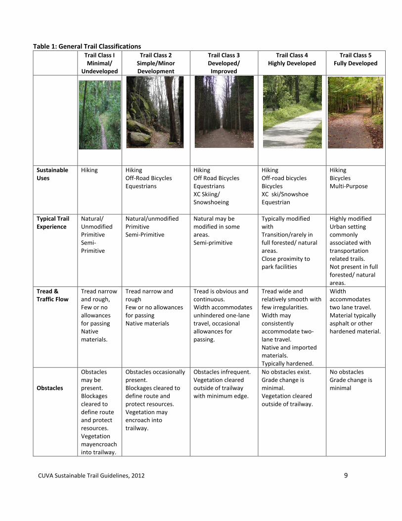
2.2.1 Trail Class. As defined by the U.S. Forest Service, “a standard trail is a trail that has a surface consisting predominantly of the ground and that is designed and managed to accommodate use on that surface.” Trail classes are general categories reflecting trail development scale. The U.S. Forest Service has established five trail classes ranging from least developed to the most developed. These classes and their level of development are:
Class 1: Primitive/Undeveloped Class 2: Simple/Minor Development Class 3: Developed/Improved Class 4: Highly Developed Class 5: Fully Developed
Table 1 outlines how the trail classification system is applied to the trails in Cuyahoga Valley National Park and their development and management level for each class. As a result of Cuyahoga Valley National Park being located in an urban environment and does not contain backcountry remote areas typically found in larger wilderness park units, Trail Classes therefore reflect the local development levels that exist within the Park.
CUVA Sustainable Trail Guidelines, 2012 9
Table 1: General Trail Classifications
Trail Class I Minimal/
Undeveloped
Trail Class 2 Simple/Minor Development
Trail Class 3 Developed/ Improved
Trail Class 4 Highly Developed
Trail Class 5 Fully Developed
Photo
Sustainable Uses
Hiking Hiking Off-Road Bicycles Equestrians
Hiking Off Road Bicycles Equestrians XC Skiing/ Snowshoeing
Hiking Off-road bicycles Bicycles XC ski/Snowshoe Equestrian
Hiking Bicycles Multi-Purpose
Typical Trail Experience
Natural/ Unmodified Primitive Semi-Primitive
Natural/unmodified Primitive Semi-Primitive
Natural may be modified in some areas. Semi-primitive
Typically modified with Transition/rarely in full forested/ natural areas. Close proximity to park facilities
Highly modified Urban setting commonly associated with transportation related trails. Not present in full forested/ natural areas.
Tread & Traffic Flow
Tread narrow and rough, Few or no allowances for passing Native materials.
Tread narrow and rough Few or no allowances for passing Native materials
Tread is obvious and continuous. Width accommodates unhindered one-lane travel, occasional allowances for passing.
Tread wide and relatively smooth with few irregularities. Width may consistently accommodate two-lane travel. Native and imported materials. Typically hardened.
Width accommodates two lane travel. Material typically asphalt or other hardened material.
Obstacles
Obstacles may be present. Blockages cleared to define route and protect resources. Vegetation mayencroach into trailway.
Obstacles occasionally present. Blockages cleared to define route and protect resources. Vegetation may encroach into trailway.
Obstacles infrequent. Vegetation cleared outside of trailway with minimum edge.
No obstacles exist. Grade change is minimal. Vegetation cleared outside of trailway.
No obstacles Grade change is minimal

CUVA Sustainable Trail Guidelines, 2012 10
Trail Class I Minimal/
Undeveloped
Trail Class 2 Simple/Minor Development
Trail Class 3 Developed/ Improved
Trail Class 4 Highly Developed
Trail Class 5 Fully Developed
Constructed Features & Trail Elements (bridges, walls, raised trail, steps, etc)
Structures are non-existent. Structures where protection of trail infrastructure and resources are needed.
Structures are minimal to non-existent, where they do exist, are limited in size, scale and number. Structures where protection of trail infrastructure and resources are needed. Natural drainage and infiltration practices are utilized Primitive foot crossing where applicable.
Trail structures may be common. Trail bridges as needed for resource protection and appropriate access. Generally native materials used. Limited drainage structures or natural drainage practices are utilized.
Structures present and substantial. Trail infrastructure meets ADA requirements. Substantial trail bridges are used at water crossings. Drainage structures are present.
Structures are present and may be continuous. Trail infrastructure meets ADA requirements. Drainage structures are present and frequent.
Trail Amenities
None/Limited/Infrequent for safety/resource protection purposes. Trailheads/Visitor Services limited or none
None/Limited/ Infrequent for safety/resource protection purposes. Trailheads/Visitor Services limited.
Limited for safety/resource protection Minor visitor services. Trailheads/Visitor Services present with limited amenities.
Amenities exist for safety/resource protection and visitor services. Trailheads/visitor services are present with full amenities.
Amenities exist for safety/resource protection and visitor services. Trailheads/visitor services are present with full amenities. Typically supported by amenities of adjacent trails.
Trail Signage Minimum for basic direction.
Minimum for basic direction. Limited to, resource protection. Limited interpretive signs
Regulation, resource protection. Directional signs at junctions or when confusion is likely. Limited and interpretive signs present.
Regulation, resource protection. Directional and park informational signs. Interpretive signs.
Directional, safety and informational signs present.
Trail Management
Low level use, through park travel. Trail challenging and typically for mid-highly skill users.Limited accessible use.
Low level use Trail challenging and typically for mid-highly skill users. Limited accessible use.
Moderate use Moderate accessible use Moderately easy travel with short intervals of challenges.
High use Users with minimal skill and experience. Easy travel with no/very limited challenges. Fully accessible.
Moderate-High use Users with minimal skill and experience. Easy travel with some challenges to accommodate connections. Fully accessible.

CUVA Sustainable Trail Guidelines, 2012 11
Trail Class I Minimal/
Undeveloped
Trail Class 2 Simple/Minor Development
Trail Class 3 Developed/ Improved
Trail Class 4 Highly Developed
Trail Class 5 Fully Developed
Maintenance Indicators & Intensity
Routine annual maintenance. Maintenance in response to reports of unusual resource problems requiring repair/ resource protection/ trail safety.
Routine annual maintenance. Maintenance in response to reports of unusual resource problems requiring repair/resource protection/ trail safety.
Routine annual maintenance. Condition Improvement maintenance scheduled on a revolving annual maintenance schedule for basic maintenance with other respective trails within park. Maintain clearance for user convenience/recreational experience. Maintenance in response to reports of unusual resource problems requiring repair/resource protection/ trail safety.
Routine annual maintenance. Condition improvement maintenance typically performed at least annually. Targeted high-level of accessibility. Trail prepared for earliest opportunity to use in-season. Maintenance in response to reports of unusual resource problems requiring repair/resource protection/ trail safety.
Maintenance typically performed bi/tri-annually. Target high-level of accessibility. Maintenance in response to reports of unusual resource problems requiring repair/resource protection/ trail safety.
Table 2: Water Trail Classifications
Water Trail
Trail Class 2 Trail Class 3
Very few or no markers or route designators. Low profile structures or facilities occasionally present; primarily to reduce streambank impacts. Structures typically consist of native material hardening of portage/water entry points. Signs or parking facilities associated with existing trailhead. Maintenance and management consists of occasional patrols and resource protection.
Launch facilities consist of a structure to provide improved access and reduce bank impacts. Well-developed parking and launch facilities with possibly separate from existing trailheads. Interpretive and informational displays may be present at primary access points. Maintenance and management consists of occasional patrols, resource protection and debris clearing where water trail is obstructed.
Source: United States Forest Service Trail Classification System.

CUVA Sustainable Trail Guidelines, 2012 12
2.2.2 Trail Types in Cuyahoga Valley National Park Ten types of trails are identified in the CVNP Trail Management Plan for the Park’s trails. Each trail type has a distinctive use and visitor experience that informs it design criteria for design guidelines recommended for each trail type. These guidelines provide a range of limits based upon the user type, intended experience, and conditions in specific trail locations. An overview of the nine types is provided below and followed by specific design guidelines for each trail type on pages 13-26. Under each trail type description, the recommended design guidance is provided for each applicable Trail Class.
Type 1: Corridor Trails. Corridor Trails are used by hikers, joggers, bicyclists and horseback riders (in designated areas) as well as service and emergency vehicles. These trails have an 8 foot trail tread width. Type 2: Equestrian/Hiking Trails. Equestrian Trails are designated as bridle trails used primarily by horseback riders and hikers. The trail tread width is 3 feet with trail clearing width 8-10 feet and overhead clearance of 10 feet. Type 3: Cross-Country Ski/Hiking Trails. Cross-country ski trails are used primarily by hikers in the summer and cross-country skiers in the winter. On these trails the tread varies due to steepness of terrain and curves to accommodate varying skier abilities. The trail tread will not exceed 5 feet and trail clearance width will not exceed 10 feet.
Type 4: Hiking Trails. Hiking Trails are used primarily by hikers. The trail tread range is 2-5 feet. Type 5: Interpretive Trails. Interpretive Trails are used by hikers and are fully accessible meeting American Disability Act standards. The trail tread width is 5 feet. Type 6: Multi-purpose Connector Trails. The Multi-purpose connector trails provide a trail connection between the Towpath Trail and the Bike & Hike Trail. These are for hikers, bicyclists, joggers and cross-country skiers. The trail tread width is 8 feet. Type 7: Neighborhood Connector Trails. The Neighborhood Connector Trails provide direct connection between adjacent neighborhoods and a Park trail. These may be for hikers, joggers, snowshoe users and bicyclists. Each trail will have a designated use. Trail width varies, based on its location, of 2-8 feet. Type 8: Off- Road, Single-Track Bicycle Trails. Single-track bicycle trails are natural surface trails used for bicycling, hiking, running, and in applicable locations, cross-country skiers in the winter. The trail tread width is 2-4 feet. Type 9: Bike Lanes. Bike Lanes are associated with the existing road network. Bike lanes are used primarily by bicyclists and are adjacent to existing roads either separated or combined with the roads. The bike lane tread width is typically 8 feet or the road shoulder is utilized in accordance with Federal Highway design guidelines for associated bike lanes on existing roadways. Type 10: Water Trails. Water Trails are associated with the use of the Cuyahoga River for non-motorized recreational boating. Guidelines will be developed through guidance set forth by Ohio Department of Natural Resources, Water Trails Program and the NPS Rivers, Trails and Conservation Assistance resource guides for Water Trails.

CUVA Sustainable Trail Guidelines, 2012 13
Trail Type 1: Corridor Corridor Trails are used by hikers, joggers, bicyclists and horseback riders (in designated areas) as well as by service and emergency vehicles. The trails have an 8 foot trail tread width. Corridor trails serve a variety of trail users because of easy terrain and proximity to visitor services. Higher volume of use places greater importance on maintaining trail conditions and trail use education. Materials: A crushed gravel mix that meets ADA standards as described in Appendix C is recommended. Where greater stability is required, pervious and non-pervious materials are recommended that align with the characteristics of the trail, trail use volume, and resource condition. Railings and boardwalks are utilized and trails are designed to meet federal accessibility requirements for recreational facilities.
Table 3: Design Guidance, Trail Type 1, Corridor Trail Class 5 – Fully Developed
Tread Width 8’
Tread Surface/Material Crushed Limestone Asphalt Permeable stabilized materials where feasible. Stream crossings are typically structures to accommodate high trail volume including bicycles and horses.
Trail Grade Target Range (>90% of Trail)
< 4% Where greater than 4%, alternative materials to aggregate should be considered in design and maintenance.
Short Pitch Max
8%
Max Pitch Density
< 3% of trail
Cross-Slope Target Range 3%-5%
Maximum
Design Clearing
Width 24” outside of trail edge
Height 8’-9’
Design Turns Radius 8’-12’

CUVA Sustainable Trail Guidelines, 2012 14
Trail Type 2: Equestrian Equestrian trails are designed for use by users riding horses and compatible with hikers. The trail tread width is 3 feet with trail clearing width 8-10 feet. Trails are designed for low volume, but increased weight bearing activities. Stream crossings for water access and resource protection require alternative design solutions. Materials: Because of the weight bearing load of equestrian trail, use, surface materials will include gravel and impervious surfaces where resource conditions require additional protection. Trail surfaces will require a compacted firm surface
for a safe and sustainable trail condition.
Table 4: Design Guidance, Trail Type 2, Equestrian Trail Class 2, Simple/Minor Development
3, Developed/Improved/ 4, Highly Developed
5, Fully Developed (recommended for limited areas where connections between primary equestrian trails require equestrian use.
Tread Width
18-36” Trail tread shall be crowned at or near 0% grade and outsloped on sidehill construction.
36”-48” Trail tread shall be crowned at or near 0% grade and outsloped on sidehill construction.
36”-48” Trail tread shall be crowned at or near 0% grade and outsloped on sidehill construction.
Tread Surface/Material
Native with limited grading. Native with some imported materials for stabilization. In poor soil conditions, the gravel will be underlaid with a geotextile woven fabric. Trail surface should be compacted to firm surface. New trails should consider stream crossings out of the stream beds. Designated stream access on existing trails will need to be identified that can be stabilized to provide horses access to water with minimal impact to water resources. The use of concrete plank ford or equivalent, or other structural material for small stream crossings is recommended. Application of stream crossing design options should consider size of watershed, resource sensitivity, stream flow volume and trail use volume.
Native with grading where necessary. Native with some imported materials for stabilization. In poor soil conditions, the gravel will be underlaid with a geotextile woven fabric. Trail surface should be compacted to firm surface. Improved stream crossings with limited stream access.
Improved with grading where necessary and imported materials for stabilization. In poor soil conditions, the gravel will be underlaid with a geotextile woven fabric. Asphalt may be used in areas where trail loads will be susceptible to recurring erosion conditions. Trail surface should be compacted to firm surface. Improved stream crossings with limited stream access.

CUVA Sustainable Trail Guidelines, 2012 15
Trail Class 2, Simple/Minor Development
3, Developed/Improved/ 4, Highly Developed
5, Fully Developed (recommended for limited areas where connections between primary equestrian trails require equestrian use.
Trail Grade
Target Range
< 10-15% < 10-15% < 10%
Short Pitch Max (up to 200’ lengths)
15-20% <15%% <10%
Max Pitch Density
< 5% of trail < 5% of trail < 5% of trail
Cross-Slope
Target Range
5% 5% 5%
Maximum 10% 10% 10%
Design Clearing
Width 48”” 48”-78” 72” – 120”
Height 10’ 10’ 10’
Design Turns
Radius 5’-6’ 5’-6’ 5’-6’
Additional Facility Design Measures
Evaluation for design measures associated with equestrian trails including, but not limited mounting blocks at trailheads, and hitching posts will be conducted for each trail.

CUVA Sustainable Trail Guidelines, 2012 16
Figure 1. Typical Section Trail Type 2, Equestrian
I I
!:: I :E :::;
.. (!)
~2 Prune iX ~ I
(TYP.) ..1 u
I I
2% MIN ~ 5% MAX ~ ~
~ < -
36" 18"
72"
CUVA Sustainable Trail Guidelines, 2012 17
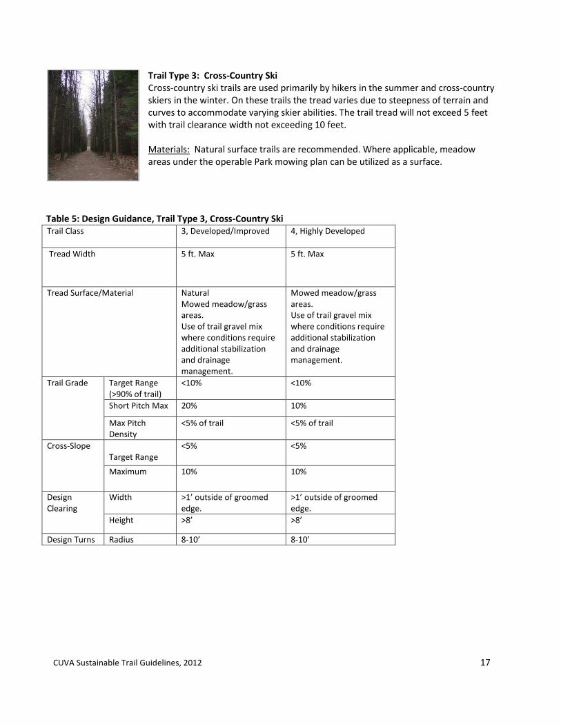
Trail Type 3: Cross-Country Ski Cross-country ski trails are used primarily by hikers in the summer and cross-country skiers in the winter. On these trails the tread varies due to steepness of terrain and curves to accommodate varying skier abilities. The trail tread will not exceed 5 feet with trail clearance width not exceeding 10 feet. Materials: Natural surface trails are recommended. Where applicable, meadow areas under the operable Park mowing plan can be utilized as a surface.
Table 5: Design Guidance, Trail Type 3, Cross-Country Ski Trail Class 3, Developed/Improved
4, Highly Developed
Tread Width 5 ft. Max 5 ft. Max
Tread Surface/Material Natural Mowed meadow/grass areas. Use of trail gravel mix where conditions require additional stabilization and drainage management.
Mowed meadow/grass areas. Use of trail gravel mix where conditions require additional stabilization and drainage management.
Trail Grade Target Range (>90% of trail)
<10% <10%
Short Pitch Max 20% 10%
Max Pitch Density
<5% of trail <5% of trail
Cross-Slope Target Range
<5% <5%
Maximum 10% 10%
Design Clearing
Width >1’ outside of groomed edge.
>1’ outside of groomed edge.
Height >8’ >8’
Design Turns Radius 8-10’ 8-10’
CUVA Sustainable Trail Guidelines, 2012 18
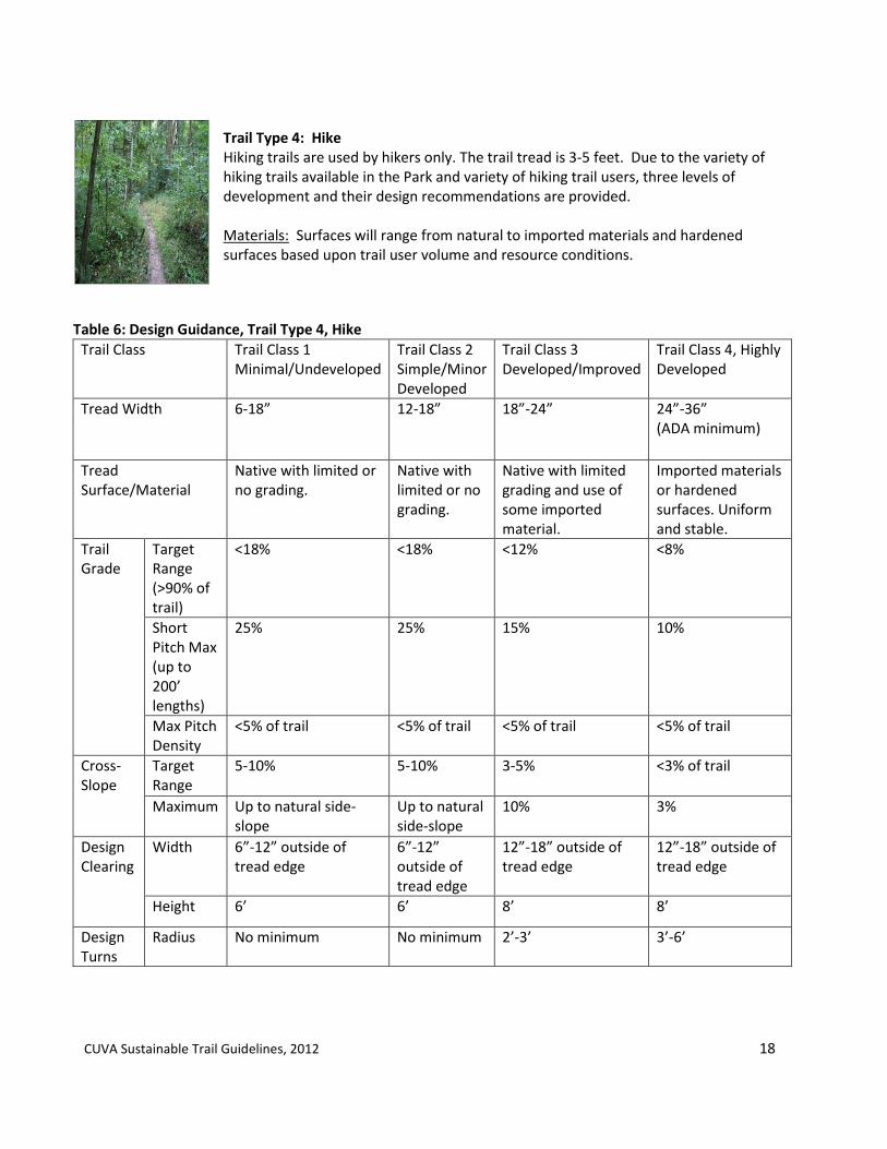
Trail Type 4: Hike
Hiking trails are used by hikers only. The trail tread is 3-5 feet. Due to the variety of hiking trails available in the Park and variety of hiking trail users, three levels of development and their design recommendations are provided. Materials: Surfaces will range from natural to imported materials and hardened surfaces based upon trail user volume and resource conditions.
Table 6: Design Guidance, Trail Type 4, Hike
Trail Class Trail Class 1 Minimal/Undeveloped
Trail Class 2 Simple/Minor Developed
Trail Class 3 Developed/Improved
Trail Class 4, Highly Developed
Tread Width
6-18” 12-18” 18”-24” 24”-36” (ADA minimum)
Tread Surface/Material
Native with limited or no grading.
Native with limited or no grading.
Native with limited grading and use of some imported material.
Imported materials or hardened surfaces. Uniform and stable.
Trail Grade
Target Range (>90% of trail)
<18% <18% <12% <8%
Short Pitch Max (up to 200’ lengths)
25% 25% 15% 10%
Max Pitch Density
<5% of trail <5% of trail <5% of trail <5% of trail
Cross-Slope
Target Range
5-10% 5-10% 3-5% <3% of trail
Maximum Up to natural side-slope
Up to natural side-slope
10% 3%
Design Clearing
Width 6”-12” outside of tread edge
6”-12” outside of tread edge
12”-18” outside of tread edge
12”-18” outside of tread edge
Height 6’ 6’ 8’ 8’
Design Turns
Radius No minimum No minimum 2’-3’ 3’-6’

CUVA Sustainable Trail Guidelines, 2012 19
Figure 2: Cross Section, Trail Type 4, Hike
1-
~ ::;
::: (,!:)
I :? z Prune ~ -0:::: (TYP.)
< LU I ..J u
I
24" 12'
48"
CUVA Sustainable Trail Guidelines, 2012 20
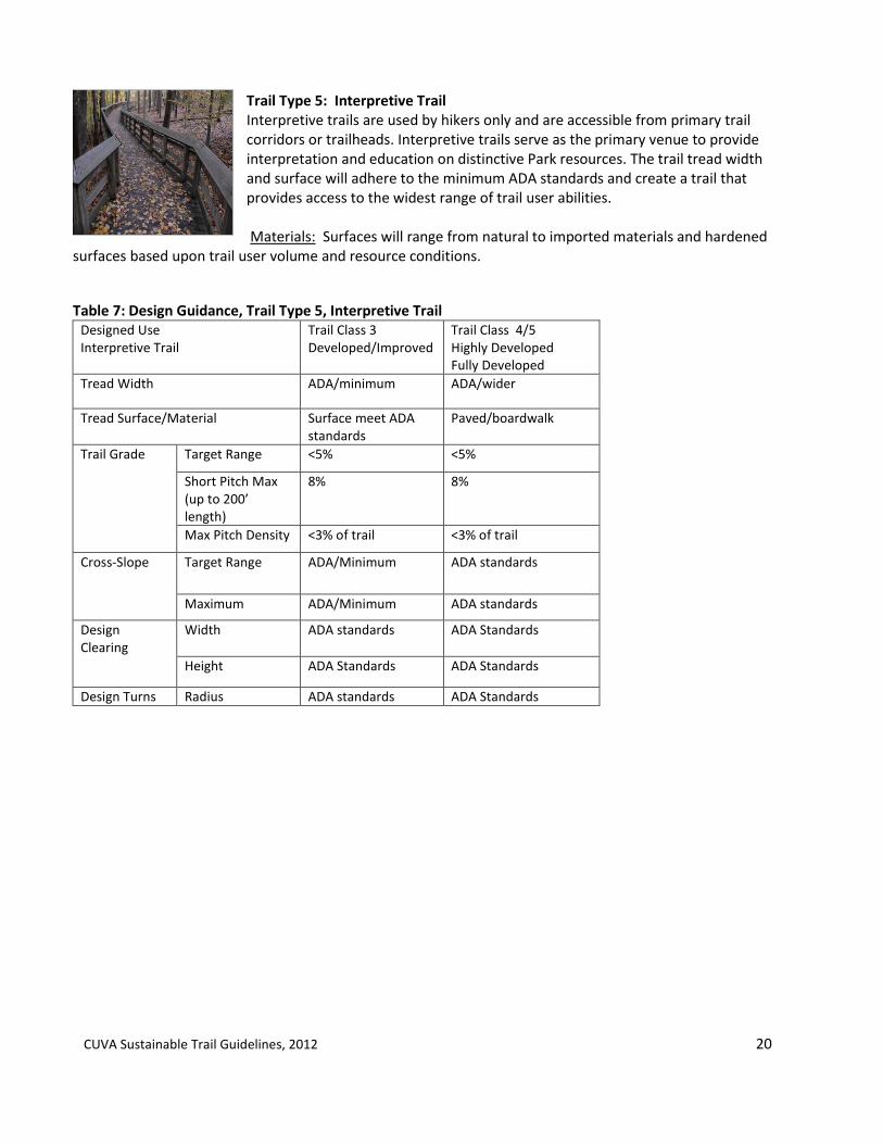
Trail Type 5: Interpretive Trail Interpretive trails are used by hikers only and are accessible from primary trail corridors or trailheads. Interpretive trails serve as the primary venue to provide interpretation and education on distinctive Park resources. The trail tread width and surface will adhere to the minimum ADA standards and create a trail that provides access to the widest range of trail user abilities. Materials: Surfaces will range from natural to imported materials and hardened
surfaces based upon trail user volume and resource conditions.
Table 7: Design Guidance, Trail Type 5, Interpretive Trail Designed Use Interpretive Trail
Trail Class 3 Developed/Improved
Trail Class 4/5 Highly Developed Fully Developed
Tread Width ADA/minimum ADA/wider
Tread Surface/Material Surface meet ADA standards
Paved/boardwalk
Trail Grade Target Range <5% <5%
Short Pitch Max (up to 200’ length)
8% 8%
Max Pitch Density <3% of trail <3% of trail
Cross-Slope Target Range ADA/Minimum ADA standards
Maximum ADA/Minimum ADA standards
Design Clearing
Width
ADA standards ADA Standards
Height ADA Standards ADA Standards
Design Turns Radius ADA standards ADA Standards

CUVA Sustainable Trail Guidelines, 2012 21
Trail Type 6: Multi-Use Connector Multi-Use Connectors provide trails between primary corridor trails (Trail Type 1). They serve bicyclists and foot traffic by hikers, runners, and walkers. Multi-use connectors are developed to meet higher trail use by a variety of trail users. Materials: Pervious and non-pervious materials are recommended that will align with the characteristics of the trail, trail use volume, and resource conditions.
Table 8: Design Guidance, Trail Type 6, Multi-Use Connector Trail Class
5, Fully Developed
Tread Width
8’-12’
Tread Surface/Material Asphalt/Smooth Surface
Trail Grade
Target Range
<5%-8%
Short Pitch Max (up to 200’ length)
8%
Max Pitch Density
< 3% of trail
Cross-Slope
Target Range 3-5%
Maximum 5-10%
Design Clearing
Width 12”-18”” outside of tread edge
Height 8’
Design Turns
Radius 8’-12’

CUVA Sustainable Trail Guidelines, 2012 22
Trail Type 7: Neighborhood Connector Neighborhood connector trails provide access to primary or secondary trails in the Park from adjacent neighborhoods. They are largely used by hikers, walkers, and runners, but in specific conditions, where connecting trails have compatible use and could allow bicycles. Neighborhood connector trails would be designed with moderate development to maintain a small footprint of the trail on park resources and maintain the primitive character of the Park to these neighborhoods. Materials: Surfaces will range from natural to imported materials and hardened surfaces based upon trail user volume and resource conditions.
Table 9: Design Guidance, Trail Type 7, Neighborhood Connector Trail Class 3
Developed/Improved 4 Highly Developed
5 Fully Developed
Tread Width
18”-36” 24”-48” 48”-72”
Tread Surface/Material Natural Natural/with material for stabilization
Asphalt/Hardened
Trail Grade
Target Range
2-10% 2-8% 2-8%
Maximum TBD TBD TBD

CUVA Sustainable Trail Guidelines, 2012 23
Trail Type 8: Off- Road Single-Track Bicycle Trails Off-Road Single-track bicycle trails are designed for bicycle use with a 2-4’ tread width on natural surface, typically in less developed areas. Single-track bicycle trails will be designed to accommodate the widest variety of user skills where feasible and to be compatible with site conditions and park resources. Materials: Surfaces will range from natural to imported materials and hardened surfaces based upon trail user volume and resource conditions.
Table 10: Design Guidance, Trail Type 8, Off- Road Single-Track Bicycle
Trail Class 2, Simple/Minor Development
3, Developed/Improved
Tread Width Corridor Width Maintenance width access
12” -18” 18”-36”
Tread Surface/Material Native Native
Trail Grade Target Range (90% of trail)
0-10% 0-10%
Short Pitch Max (up to 200’ in length)
15%-25% <15%
Max Pitch Density
Cross-Slope Target Range 5-20% 5-20%
Maximum
Design Clearing
Width
1’ from edge of tread 1’ from edge of tread
Height 8’ 8’
Design Turns
Radius <20’ *climbing turns should exceed a 7% grade to minimize erosion.
<20’ *climbing turns should exceed a 7% grade to minimize erosion.
(Cleveland Metroparks)

CUVA Sustainable Trail Guidelines, 2012 24
Figure 3: Cross Section Trail Type 8
1-
~ ::::i
:: (!) 9 z
I ooc;:: Prune ~ (TYP.) ....J
I u
I
18" 12'
42"

CUVA Sustainable Trail Guidelines, 2012 25
Trail Type 9: Bike Lanes Bike lanes are primarily used as a non-motorized alternative transportation to serve as connectors to Park facilities where other separated routes are not feasible. Bike lanes are associated with the existing road network. Bicycle lanes are used primarily by bicyclists adjacent to existing roads either separated or combined with the roads. A bike lane tread width is 8 feet or the utilization of a road shoulder in accordance with Federal Highway Administration design guidelines for associated bike lanes on existing roadways (AASHTO, 2010).
Materials: Bike lanes surfaces will typically be associated with the road surface it is utilizing. Surface materials should consider user volume, resource conditions and necessary and available maintenance. Table 11: Design Guidance, Trail Type 9, Bike Lanes
Trail Class (AASHTO/Ohio DOT Guidance)
Class I Class II Class II
Description Bike paths separated from motorized vehicle traffic and have a limited number of intersections with roads, sidewalks and hiking or bridle trails.
These trail systems are located in a designated bike lane on a street shared with motorized vehicles. Bike lanes may be painted, curbed, or separated by vegetation.
These trails are typically where bikes share the road with motorized vehicles. Signage indicates that the road is traveled by bike traffic.
Tread Width
8’
Tread Surface/Material
Gravel material typical of Corridor materials.
Paved or unpaved material, with pervious or impermeable surface applications. Resource conditions will determine suitable surface material.
Surface associated with roadway it is utilizing.

CUVA Sustainable Trail Guidelines, 2012 26
Trail Type 10: Water Trails The water trails and associated facilities for river use will be developed utilizing design guidelines set forth by the Ohio Department of Natural Resources, http://ohiodnr.com/watercraft/trails/howto/tabid/2898/Default.aspx , the NPS Rivers and Trails Conservations Assistance Program., and the design requirements subject to park and NPS resource conditions and policies. The Park will establish design guidelines for paddle launch sites and river access as part of its design development that will be incorporated in updated Sustainable Trail Guidelines, when available. This section will be updated as river access facilities are further developed.
CUVA Sustainable Trail Guidelines, 2012 27
Section 3: Guidance for Site Planning and Design This section provides general guidance to assess site conditions during trail site planning within Cuyahoga Valley National Park and general guidance for trail design and its supporting amenities. The guidance is set forth to support the environmental screening required for NEPA compliance and align with the procedures described for the Trail Team in Section 2.
3.1 General Site Assessment Site planning for a new or restored trail is the first step to establish a safe and sustainable trail for visitors to enjoy. Evaluating general site conditions during preliminary trail alignment are critical to the long term management and sustainability of the trail and surrounding park resources. The following site conditions are recommended for site assessment throughout the planning and design phase of a trail project. Once completed, a general concept plan of the trail layout area and its associated resource issues and conditions should be developed.
3.1.1 Trail Location. The initial general location of the trail should be identified. The identification of the general area will define the zone at which to evaluate the site conditions described in this section that will further assist in identifying the final trail alignment. With all trail locations, consideration of use corridors that already exist and meet the recommendations of these guidelines should be evaluated during the initial site assessment process. 3.1.2 Natural Resources Sensitive Habitats and Seasonal Nesting Areas. New and existing trails should avoid sensitive areas where: a rare and/or endangered plant or animal species exist, or is known habitat for a rare or endangered species. Trails should also avoid seasonal nesting areas or the park shall adhered to seasonal park policy, such as temporary closures, on trail use or tree clearing for those specified areas . A review of site conditions where sensitive habitats may exist within the trail planning area shall be conducted with the park biologist and if necessary with U.S. Fish and Wildlife Service. If conditions exist, establishment of buffers based upon habitat sensitivity shall be developed where trails are excluded, temporary seasonal closures would be required, or limitations on seasonal construction. When resource conditions are within areas with multiple jurisdictions or require additional expertise, the park biologist may request additional review of conditions with partner biologists. Viewing of distinct park features should also be identified during site assessment and the feasibility for visitor access. The Park currently has an established policy for recreation and maintenance activity within the area of the bald eagle within the Pinnery Narrows region of the Park during nesting and fledgling season in accordance with U.S. Fish and Wildlife recommendations. Consultation with U.S. Fish and Wildlife Service is to be conducted for each trail project site during implementation for evaluation of impacts to the Indiana bat and its habitat.
Rivers/Streams/Stream Crossings. Trails adjacent to or crossing rivers and streams will need to consider the riparian buffer zones or setbacks during site planning and design. Establish trail location outside of the established riparian function buffer zone whenever feasible. If trails are sited for river viewing purposes within the riparian function buffer zone, adherence to the Park’ Streambank Stabilization Plan guidance shall be reviewed.

CUVA Sustainable Trail Guidelines, 2012 28
Trails should minimize the number of stream crossings along a segment and should be avoided whenever possible to minimize the impact to the stream. Where the trail does need to cross a stream, evaluation of the stream quality should be identified to plan the appropriate stream crossing accordingly with the stream’s resource sensitivity. Stream crossings should be located at riffle areas instead of at pools or meanders, as riffles are relatively stable, have the coarsest substrate, and can best accommodate a crossing (IMBA, 2004). All stream crossing shall be evaluated in compliance with Director’s Orders 77. Wetlands. Trails whenever possible should avoid placement within a designated wetland. The park contains a wide range of wetlands in quality and size. A review of the park’s wetland inventory should be conducted to determine location, size, quality and other resource information. Evaluation to improve wetland quality and conditions where trail elements may lie within or adjacent to shall be part of the design process conducted by trail design team General restrictions of trails within wetlands are as follows.
Table 12. Wetland Evaluation for Trails
Wetland Category
Definition Ohio Administrative Code Rule 3745-1-54 (C)(1)
Recommended Action
Category I Supports minimal wildlife habitat and minimal hydrological and recreational functions. Do not provide critical habitat for threatened, rare or endangered species and may have predominance of non-native species. Limited for restoration.
Use of boardwalk systems are required and designed with minimal impact to wetland.
Category II Support moderate wildlife habitat and hydrological and recreational functions. Dominated by native species but typically do not support threatened, rare or endangered species.
Full restriction to trail installation is recommended. If the trail cannot support an alternative route and have high interpretive value, a trail within 25 feet of the wetland shall use a boardwalk system with minimal impact.
Category III Supports high levels of diversity and high quality wildlife habitat, hydrological and recreational functions. Contain high levels of diversity, high proportion of native species and provide habitat for threatened, or endangered species.
Full restriction to trail installation is recommended. If the trail cannot support an alternative route and has high interpretive value, a trail within 75 feet of the wetland, shall use a boardwalk system with minimal impact.
All trails where wetlands may be affected shall be evaluated in compliance with Director’s Orders 77. Where the proposed trail is within 125’ of a wetland, additional site evaluation by a wetland biologist may be required. Each proposed Class II and Class III wetland should be evaluated on site by the park ecologist or wetland biologist to determine its impact and options for implementation. Where pertinent, the evaluation should include an ORAM (Ohio Rapid Assessment Method) evaluation to determine quality of the wetland

CUVA Sustainable Trail Guidelines, 2012 29
and any additional wetland delineation. Any impacts or changes to identified wetlands are required to develop and submit a Clean Water Act CWA 404 permit through the U.S. Army Corps of Engineers and required permits by Ohio EPA. Drainage. There is no other single factor with as much ability to damage the trail as the unchecked flow of water. Problems occur when the trail interrupts the processes of natural drainage. The trail can intercept sheet flow or stream flow and become itself a stream channel. When the trails become wet, puddle or become muddy, trail users will utilize the side of the tread, thus widening the exposed soil of the tread. Trail alignment on topography that assists to minimize long term drainage issues should be evaluated during the site planning phase of the trail. Avoidance of trails on primary drainage paths and utilization of contour trail design should be evaluated during the initial site assessment phase of the trail layout. Additionally, evaluation of natural stormwater management methods should be conducted. Trail siting on sustainable topography is recommended to be evaluated utilizing the following options to determine trail implementation. The park will evaluate the long term management of the trail in these conditions with the following options 1) drainage conditions are not sustainable through natural drainage or require substantial infrastructure: abort trail (new or existing), 2) drainage conditions are feasible naturally or with infrastructure: design trail with modifications that address adverse drainage conditions, or 3) drainage conditions are feasible with natural drainage methods: design trail as planned. Vegetation. New and existing trails should avoid rare plant species or large tracts of forest areas with high diversity and quality. The Park contains four primary vegetative zones; bottomland forest, upland forest, grasslands and meadows and wetlands/marsh. Sensitivity to the characteristics and resources within these zones should be evaluated. In addition, areas under ecological restoration should be identified during initial trail planning to minimize disturbance to the restoration process. Alignment of trails should reduce fragmentation of existing blocks of forest. Two actions should occur to verify the presence of rare plants in proposed trail areas. First, a review of historical plant data and a site survey should be conducted by the park landscape architect in coordination with the park plant ecologist. Secondly, a site survey, upon initial flagging of a proposed trail alignment, will be conducted to identify rare plants or sensitive vegetative communities where initial review may identify the presence of sensitive species. The survey will be conducted by qualified park or contract professionals to identify conditions in a trail planning area with a 100% visual survey of the proposed alignment. The establishment of buffers based upon vegetation sensitivity shall be conducted for each trail project as conditions deemed necessary by the park landscaped architect in coordination with the park plant ecologist. Disturbed and Developed Areas. Disturbed or developed areas are areas in which ground disturbance has occurred from previous activities, not necessarily from trails. They are typically utility corridors, roads or other lands where disturbance as occurred such as demolition. Where trails are proposed in disturbed or previously developed areas of the park, considerations and verification of the following items should be included; presence of utilities, established right of ways, remaining structures, cultural or archeological significance, or presence of hazardous materials or contaminated conditions. If any of these conditions exist on the proposed site, a determination of impact and trail alignment options will need to be developed to address the conditions present. Soil Conditions. The soil conditions need to be considered when determining final layout of a trail. Conditions related to a soil types, susceptibility to erosion, drainage and permeability characteristics, and its compatibility for recreational use should be evaluated. The USDA NRCS Soil Survey information for Cuyahoga Valley National Park will be utilized as the primary reference. Additional site evaluation, through soil borings as deemed necessary by the park planner/trail designer/park engineer will be determined if the Soil Survey

CUVA Sustainable Trail Guidelines, 2012 30
information identified conditions that are adverse to a sustainable trail. When adverse trail conditions are identified in the soil survey information, the park will determine alternative options for trail design and its implementation: 1) abort trail (new or existing), 2) design trail with modifications that address adverse soil conditions, or 3) design trail as planned.
3.1.3 Cultural Resources. The Park will conduct a site plan survey of any potential conditions related to a trail within close proximity to historic structures, cultural landscape features or archeological areas. Coordination with the park’s historic architect, landscape architect and the regional archeological division at the site plan level to address these items for trail alignment will be conducted during the trail preliminary layout phase of the project. The level of evaluation will be predicated on the design of the trail and its local resource conditions.
3.2 Physical Design Once a general area has been selected and marked, alignment design of the trail is the next step to trail development. Establishing baseline design principles for every trail, whether it be an improvement to an existing trail or the development of a new trail, will be essential for the long-term sustainability of the trail system, minimizing its impact to park resources and providing a safe and enjoyable experience for the park visitor. These general design principles have been compiled from other recent National Park Service Trail Plans and guided from past work and publications on sustainable trail development throughout the United States. These principles should be considered part of the design development and construction practices for every trail in CVNP. Upon the completion of the physical design phase of the trail, a defined trail layout should be drawn, including required infrastructure in which a final design and construction drawings can be developed from.
3.2.1 Trail Location. The most sustainable trails are located along sidehills. Sidehill design assists with water drainage on the trail and keeps users on the trail preventing trail widening. Where available in the Park, utilize sidehills for laying out the trail alignment. Where applicable and conditions exist, full bench construction is recommended.
3.2.2 Trail Alignment. Sustainable trails traverse slopes rather than directly descending a hill side. A trail traversing a slope allows for sheet runoff of water, which will cause less erosion and minimize the creation of gullies. The following design principles and their use should be evaluated for each trail.
The Half Rule. The grade of a trail should not exceed half of the grade of the sidehill on which it is located. Exceptions to the half rule occur when soils in the location of the trail are prone to erosion, in which case the maximum sustainable trail grade may be considerably less than half of the grade of the sidehill. Except in rare and limited situations, the grade of a trail should not exceed 15 percent. In less developed trails, the cross-slope should exceed the running slope. Sustainable Grade. The overall average grade of the trail should be generally 10% or less. An average grade of 10% or less can decrease the impacts of erosion. Grade reversals. A grade reversal is a brief change in elevation where the trail drops subtly before rising again. Incorporating the use of grade reversals in trail design will assist in water drainage and minimize the potential for erosion.

CUVA Sustainable Trail Guidelines, 2012 31
Outslope. Trails should be built with a slight tilt (about 5%) of the trail tread toward the low side of the trail. Where outslope is difficult to implement, the use of grade reversals should be considered.
3.2.3 Design with Natural Resources. When avoidance of natural resource disturbance is not feasible, designing the trail to minimize its impact will be required. Best practices and sustainable design methods that complement the natural features and minimize their disturbance will be utilized. The following guidance pertains to trail design within park resources. Alignment outside of Buffer Zones. Ensure trail alignment design is outside of buffer zones identified during site assessment for sensitive natural resources and cultural resources or management and design measures areas established when the trail is necessary to travel within established buffer zones. U.S. EPA recommends a protected buffer of 50 feet around wetlands and streams where siting of campsites, parking areas or other structures be avoided. Drainage. Design methods to manage stormwater and trail runoff naturally through dissipation and infiltration that will reduce runoff velocity, erosive conditions and stream headcutting should identified and developed as part of the overall design of the trail. Additional infrastructure that is required to meet drainage requirements, should also be identified on the site plan. Stream Crossings. When stream crossing is the only viable option, it should be designed and constructed on a gentle grade at no greater than an 8% grade. Gradually sloping stream banks on which to locate the crossing is recommended to minimize impact (IMBA, 2004). Trails should not parallel a stream for an extended distance. If the trail should need to travel along a waterway, the trail should be aligned in a manner that it moves toward and away from the waterway at intervals that are determined appropriate for the size of the river or stream and the existing riparian habitat conditions. Boardwalks crossings for streams should span the channel of the stream and any boardwalk posts or fill should be kept above the ordinary hig water mark of stream channels. Wetland Boardwalks. If a trail is constructed within a wetland, a boardwalk system is recommended. The boardwalk design should provide a layout that minimizes the width of the boardwalk tread, the number and size of pilings needed for excavation and the use of best practices that minimize the size of excavation. Additionally, trail or boardwalk construction in or near wetlands should consider the following practices to minimize impacts to aquatic resources: construct during winter if feasible, minimize width of temporary access roads for construction access Any impacts or changes to identified wetlands are required to develop and submit a Clean Water Act CWA 404 permit through the U.S. Army Corps of Engineers and required permits by Ohio EPA.
3.2.4 Soil Suitability. Sustainable trails consider the soil conditions and user patterns to identify design measures required for long-term sustainability. Adaptation to Soil Texture. Develop the trail based upon the local soil conditions, related to drainage, erodibility, cohesion and durability. The use of the USDA NRCS Soil Survey to assess local soil conditions is recommended during trail planning and design.
Minimization of User-Caused Soil Displacement. Design trails that avoid, where feasible, abrupt corners and sharp hills, and incorporates consistent flow, insloped turns and use of trail hardening practices where trail is susceptible to soil displacement.

CUVA Sustainable Trail Guidelines, 2012 32
3.2.5 Infrastructure. Once a general trail alignment is determined, further layout of infrastructure will be identified. Determination of the type of infrastructure, costs, and general design will need to be assembled during the site design phase.
3.2.6 Maintenance. Sustainable trails aim to require less maintenance and fewer resources to maintain its intended use. Maintenance of trails should work to keep original design of trail and use sustainable techniques to respond to problem areas. Recommended practices for maintenance are further described in Section 4 of this document (New River Gorge EA/Managing Mountain Biking: IMBA’s Guide to Providing Great Riding (Webber, 2007)).
3.3 Trail Facilities
The Park’s trail system contains support facilities to provide access and amenities to a visitor’s trail use. The design and types of facilities are an important piece to the management and use of park trails. The following guidelines will be considered for each trailhead or facility servicing as an access point for the Park’s trails.
3.3.1 Sustainable Design and Climate Friendly Practices. All new and improvements to existing trail facilities shall be designed and developed recognizing the character of the park and aim to meet NPS Climate Friendly and Sustainable Design Guidelines. Utilization of low impact design standards including LEED (Leadership in Energy and Environmental Design) Sustainable Sites and Building Guidelines, including use of recycled materials, EPA’s WaterSense program, the Park’s Environmental Management Program and other similar programs should be considered where applicable.
3.3.2 Evaluation of Energy Harvesting from Towpath Trail Use. Energy harvesting is the method, for this purpose of extracting energy of human movement within the Park and recycle the energy for another use in the Park. The emergence of technologies of micro-generation of energy by human movement, through piezoelectricity (Bates, 2010) should be evaluated for its application and feasibility on the Towpath Trail and Multi-Use Connector Trails, to generate energy for lighting and trailhead facilities.
3.3.3 Trail Amenities. Trailhead Locations. Trailheads are places that serve as a starting, ending, or interim points along a trail that provides information and, potentially, facilities at varying levels of services to the trail user and park visitor. The level of facilities at a trailhead shall be determined by the current and anticipated amount of use, type of use and proximity to other trailheads in the park. Siting of new trailheads should consider environmental conditions similar to the trail site planning to avoid and minimize environmental degradation at all times. Design of the trailhead should reflect the desired trail class experience, cultural landscapes, and structures in which it exists. Parking. As outlined in the NPS Management Policies (Section 9.2.4, Parking Areas), “permanent parking areas will not normally be sized for the peak day, but rather for the use anticipated on an average weekend day during the peak season of use.” This guidance should be used in consideration of adding, reducing, relocating, and/or eliminating parking areas within the park. Materials for parking areas, including the use of porous or permeable pavement will be determined based upon site conditions, use levels and use types with the goal of minimizing impervious cover that the park contributes within the watershed. Use of natural stormwater techniques such as bioswales, use of vegetated buffers and inlets around and in paved areas to further increase infiltration and other natural methods should be evaluated for each parking area design. Parking design will take into consideration the types of vehicles associated with trail use, including equestrian

CUVA Sustainable Trail Guidelines, 2012 33
trailers where parking areas are utilized for equestrian trail access. Restrooms. New and/or improved restroom facilities should be designed utilizing NPS Sustainable Design Guidelines (NPS, 2009a) and NPS Climate Friendly Guidance (NPS, 2012). Types, quantity, and locations for restrooms will be based upon use, maintenance requirements, and access.
Bike Racks/Parking Areas. Bike racks shall be installed at all designated trailheads along the Towpath Trail that are authorized for bicycles and other applicable trailheads where bicycle use is authorized. Design and placement of the bike racks shall reflect and maintain the character of the park and its resources. Materials for bike racks shall provide minimal additional maintenance when installed.
Benches. Benches will be located along trails and at trailheads where applicable. Benches shall fit the character of trail type and adjacent park features and will adhere to the bench standards currently in place for the Towpath Trail, trailheads, and other trails. These bench design standards are provided in Appendix D. Picnic Tables. Picnic tables will be limited to designated picnic areas of the park and generally not located on trails with the exception of visitor centers with access to the Towpath Trail and other day use areas of the park. Water Stations. Where feasible, potable drinking water will be available for visitors at each trailhead along the Towpath Trail. Other trailheads will be evaluated for water facilities where feasible for installation. Trail Shelters. Shelters for extended outdoor activities along the trails or trailheads will be evaluated as requests are submitted for such use by park staff. If implemented, siting, design and materials of shelters shall be evaluated for annual estimated use, use types, and character of current or future trail development levels.
3.4 Trail Signage
The Park will continue to update its Sign Plan and use the UniGuide Sign Standards with three levels of signage: identity signs, motorist guidance signs, and the visitor information system. Trail and trailhead signage guidance is detailed in the visitor information system. Trail accessibility information is recommended at all trailheads. Accessibility information should include the following information to the trail user; length of trail, types of users permitted on trail, average trail grade, number of feet on trail loop or segment greater than 5% and greater than 8%, average cross-slope, number of feet of the trail that is greater than 3%, average and minimum trail width, surface type, and other types of hazards such as rocks and roots on trail.. A variety of trail information should be available to trail users through trailhead signage, on-trail information, trail maps, and utilization of digital media at trailheads and through mobile applications.
3.5 Accessibility & Mobility Guidance
It is the goal of the NPS to ensure that all people have the highest level of accessibility that is reasonable to our programs, facilities and services in conformance with applicable regulations and standards as outlined in Director’s Order #42: Accessibility for Visitors with Disabilities in National Park Service Programs and Services. It is the intent to provide accessibility within all trail and facilities within the Park. Each trail and its associated amenities and facilities will be evaluated on its conditions, determine its level of accessibility and integrate applicable design methods into the trail design. Guidance to evaluate and determine accessibility design for trails is outlined in Appendix E. Additionally, use of other power-driven mobility devices for the purpose of

CUVA Sustainable Trail Guidelines, 2012 34
accessibility will be evaluated for each trail. This will be coordinated by the park landscape architect or primary designer for the project during the trail design process. The evaluation and determination of design will be integrated into the trail development planning process for the project and in compliance with the applicable laws, standards, and park policies.
Section 4: Trail Construction This section outlines general guidance for construction of trails, including new and realignment or improvements of existing trails.. Collaboration on trail design, with maintenance and resource management professional disciplines and utilization of new trail construction techniques are the cornerstones for successful construction of the trail and its long term sustainability. Utilizing the best practices to construct a new trail or improving an existing trail will be critical to its future maintenance and management. The following general guidelines are recommended for basic activities and methods to utilize during trail construction. The Park’s trail guidelines and practices shall stay updated to trail industry standards, nationally and regionally, that are beneficial to the trail user and park resources. Information in this section is adapted from various Trail Guidance Manuals identified in the reference section of this document, but primarily from NPS, Minnesota DNR Trail Guidelines, and IMBA’s Trail Solutions Manual.
4.1 General Guidance on Primary Trail Construction Practices
4.1.1 Clearing. Clearing vegetation for any new trail will be coordinated with the park staff consisting of disciplines in or equivalent to planning and design, plant ecology, biology and trail construction and maintenance during field verification. The amount of trail clearing needed will be based upon the trail’s designated primary use as identified in the Trail Types identified in these Guidelines and resource conditions in the trail location. Trail clearing should be made as narrow as possible.
For protection against erosion and to maintain resource integrity as much as possible, native vegetation should be retained as much as possible. Healthy trees of any size should not be removed except where they interfere with trail traffic and/or the trail cannot be relocated to eliminate the interference. All healthy trees over 12 inches diameter breast height, (DBH) should remain. Where natural plant restoration is not able to occur from soil disturbance, revegetation by the park with native plants should be assessed and occur where necessary. This practice should apply to trail tread and the construction of turnpikes and other structures that can create disturbance during construction.
4.1.2 Base Construction. Construction of sidehill trails usually requires grading the bed for the trail, but if the existing surface is flat and provides a suitable tread, leave it undisturbed. This will reduce erosion and maintenance. On level ground, form the trail base by building up rather than cutting down. Remove all duff before making cuts or fills for the tread.
Start grading on the upper slope and carry it down to the finished grade. The usual procedure is to “scratch” a continuous line along the upper slope using a Pulaski. Remove any excess duff at this time. Begin excavation along this line using the appropriate equipment for the trail. The depth, width and material of surfacing are determined by the quality of the native material and the class of the trail as specified in these guidelines.

CUVA Sustainable Trail Guidelines, 2012 35
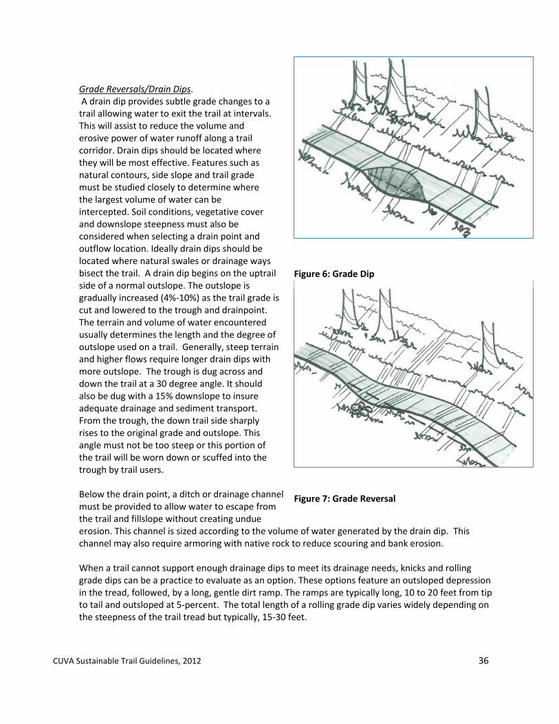
4.1.3 Drainage. Proper drainage is a key component to the sustainability of any trail. Drainage control on a trail relates to two primary types of water control; surface and subsurface water. Surface Drainage. Methods to manage surface drainage include outslope, grade reversals, drain dips, varying the trail grade, and armored crossings.
Outslope. Establishing an outslope to a trail will assist water to sheet across and off the trail instead of funneling down its center. Outslope design should exceed running slope to be effective. If loose soil is present, the incorporation of grade reversals is recommended.
Figure 4: Sheetflow
Figure 5: Outslope
CUVA Sustainable Trail Guidelines, 2012 36
Grade Reversals/Drain Dips. A drain dip provides subtle grade changes to a trail allowing water to exit the trail at intervals. This will assist to reduce the volume and erosive power of water runoff along a trail corridor. Drain dips should be located where they will be most effective. Features such as natural contours, side slope and trail grade must be studied closely to determine where the largest volume of water can be intercepted. Soil conditions, vegetative cover and downslope steepness must also be considered when selecting a drain point and outflow location. Ideally drain dips should be located where natural swales or drainage ways bisect the trail. A drain dip begins on the uptrail side of a normal outslope. The outslope is gradually increased (4%-10%) as the trail grade is cut and lowered to the trough and drainpoint. The terrain and volume of water encountered usually determines the length and the degree of outslope used on a trail. Generally, steep terrain and higher flows require longer drain dips with more outslope. The trough is dug across and down the trail at a 30 degree angle. It should also be dug with a 15% downslope to insure adequate drainage and sediment transport. From the trough, the down trail side sharply rises to the original grade and outslope. This angle must not be too steep or this portion of the trail will be worn down or scuffed into the trough by trail users. Below the drain point, a ditch or drainage channel must be provided to allow water to escape from the trail and fillslope without creating undue erosion. This channel is sized according to the volume of water generated by the drain dip. This channel may also require armoring with native rock to reduce scouring and bank erosion. When a trail cannot support enough drainage dips to meet its drainage needs, knicks and rolling grade dips can be a practice to evaluate as an option. These options feature an outsloped depression in the tread, followed, by a long, gentle dirt ramp. The ramps are typically long, 10 to 20 feet from tip to tail and outsloped at 5-percent. The total length of a rolling grade dip varies widely depending on the steepness of the trail tread but typically, 15-30 feet.
Figure 6: Grade Dip
Figure 7: Grade Reversal

CUVA Sustainable Trail Guidelines, 2012 37
Armoring the tread. When natural drainage and/or use types create conditions that prevent the maintenance of a natural tread and no other locations are available the use of hardening material is recommended. Hardening the tread will minimize maintenance, stabilize the surface for the use impact and minimize erosion and drainage impacts to the natural resources. Other armoring techniques to evaluate for use include geosynthetics, stepping stones and rocks. Mixed aggregate: Mixed aggregate is typically used on trails typically located on flat terrain with poor drainage and where the use of dips and reversals are not feasible. Aggregate mix material comprising of the trail mix material is recommended for this application. Appendix C describes trail materials recommended for the variety of trail surface conditions.
Turnpike. Turnpike construction is used in areas where the trail tread remains very wet during the year and no relocation options are available. Turnpiking designs the trail tread higher than the water.
Edge Protection. Where a trail travels along a sideslope, drainage and erosion issues can arise due to trail user patterns. Edge protection techniques should be evaluated and considered in these locations to assist in stabilizing the trail and reducing maintenance. Techniques to consider include, insloping the trail, adding tread width, especially on limited sight line trail sections, establishing a vegetative shoulder, or installing a constructed barrier, such as low wall, rail or fence. Site conditions, trail use, trail type and desired trail experience should be factors in determining the best technique. Tread Watersheds. A tread watershed consists of the tread surface plus any uphill area where runoff flows onto the trail and down to a dip between two crests. This design approach will assist in preventing erosion on the trail. Designing the trail with a rolling grade with crests and dips will assist in creating tread watersheds as to contribute to a sustainable trail. (Minnesota DNR, 2006)
4.1.4 Trail Climbs. To maintain sustainable grades but meet the topographic terrain that exists within the park, trails will require direction changes or designed at sustainable grades to help gain the elevation at a consistent and sustainable grade. Tread climb relates to the steepness and length of a trail overall and between individual tread crests and dips. In general, tread climbs should not exceed one-fourth to one-third of the fall-line or the direct drainage paths of the natural terrain. Fall line climbs should be avoided at all times when possible. When fall-line climb trails are necessary, maintaining sustainable grades based upon the tread material, soils conditions and existing grades is recommended. This can be achieved by establishing a sustainable trail length between the crests and dips of trail in relation to the tread grade and tread material.
Climbing Turns. Climbing turns should be used on grades that do not exceed 7-percent. Turn radii should be wide, generally 20 feet or more. Incorporating a grade reversal just above the turn is recommended. Armoring the fall line section of the turn and adding a choke point to slow users prior to the turn will reduce user-caused erosion.

CUVA Sustainable Trail Guidelines, 2012 38
Switchbacks. Switchbacks are sharp directional changes on a trail in order to gain elevation where areas are limited in space. Switchbacks should be avoided is possible. When switchbacks are necessary, construct the turns as flat as possible. On sideslopes of less than 30 percent, treat the switchback as a climbing turn. If this results in the center line grade being steeper than is desirable, shorten the radius and design a step section. Provide 15-30 feet of barrier back from the turning point to prevent trail users from crosscutting inside the switchback. A gutter type ditch, 8 inches deep and 12 inches wide across the top, shall be constructed along the bottom of the cut bank to extend from the spill point up grade for a distance of 20 feet. The trail tread paralleling the ditch shall have a 10% inslope that will drain water from the tread into the ditch. The tread surface, down grade from the crown line for a distance of 20 feet shall be constructed with a 10% outslope that will drain water off the trail. A traffic control barrier shall be constructed by placement of large rock along the outer edge of the up grade trail section forming a continuous barricade. The barrier shall be a minimum of 14 inches high and extend from the crown line on the turn section up grade for a minimum distance of 15 feet. Consideration of hand rails should be assessed where applicable and necessary where steep grades or drop-offs exist. The upper and lower 20 feet approach sections extending away from the turning point and the turn section shall be constructed to have not less than the trail tread width. The tread on the approach sections and on the turn section shall not exceed the prevailing grade of the trail and have no surface rocks over 2 inches in diameter or solid rock protrusions above the trail bed.
4.1.5 Drainage Crossings. Crossings of streams can have significant impacts to the resource conditions if not implemented properly. At all times, avoiding drainage and stream crossings is the preferred option. If this cannot be avoided, the following drainage crossing options will need to be evaluated and considered to determine the best option for a specified trail area. Determination of the best methods for drainage crossings shall be evaluated in compliance with Director’s Order 77. Drainage crossing design should consider characteristics of the trail, level of use and level of development of the trail.
Direct Crossing. If drainage flows are intermittent, evaluation of the installation of a primitive crossing should be evaluated by the use of the trail, type of trail, and resource conditions. If the trail begins to alter the drainage flow, then other crossing options will need to be installed.
Hardened Tread Crossing. Hardened tread crossings should only be used where water depths during high flow are less than 3 feet, water velocities are low, trail use is low and water quality conditions will not significantly change. Hardening techniques include use of stones, gravel, cobble with geotextile fabric underneath when applicable. These materials should be used at sizes appropriate for the stream conditions and trail type. In addition, hardened tread crossings for equestrian trails may include concrete, similar to a concrete plank ford should be considered where bridge structures are limited by water resource conditions and the concrete technique is suitable to the water resource condition for the trail crossing. Culverts. Elevated crossing are preferred over culverts as culverts can alter the water quality and stream functions significantly depending on the drainage size. Culverts should only used with drainages when other natural water management methods are not feasible for site conditions.

CUVA Sustainable Trail Guidelines, 2012 39
Bridges/Boardwalks. Bridges and boardwalks are the preferred method for drainage crossings, when avoidance of waterway crossings is not possible. The scale, width and materials for structures should be compatible with trail use, trail experience and minimizing resource impacts. Span of bridges should aim not to install piers or footers into waterway. Spans greater than 24 feet should examine alternative material from wood to maintain its long-term sustainability. A minimum bridge width should match the width of the trail. Railings, materials and styles should be considered for the level of use, ADA requirements, proximity and characteristics of trail. Materials should be selected based upon structural integrity and site appropriateness. Cultural landscapes and historic characteristics of the area should be considered during design. Appendix F, outlines general design guidelines for trail bridges.
4.1.6 Other Structures. Trails may require additional structures to protect the resource and provide a safe, trail corridor for its users. These structures include but are not limited to retaining walls and steps.
Retaining Walls. Retaining walls are structures of wood or stone designed to stabilize the trail base on a sideslope. Native logs should be used only if rock is not readily available. A solid foundation on earth or rock is required to obtain a rigid, safe retaining structures and the removal of water behind the wall is necessary for its design Steps. Steps should be discouraged as structure all times to minimize infrastructure, maintenance and accessibility restrictions. Steps are recommended where the physical conditions prohibit the alignment of a trail with the natural topography and to insure a safe trail.
4.1.7 Trail Restoration. Once a trail has been designated closed or a section relocated, the closed or old trail will be restored to a natural condition consistent with the location’s natural resources. Recommended steps to take in reverting the trail to a natural condition and avoid the continuing use of the trail include: 1) Tilling or scarifing the retired tread so that new plants can seed themselves. Tilling at least 2 inches deep is recommended. 2) Planting or transplanting from old route native species to avoid invasive plant issues. 3) Disguising and blocking the corridor with leaf litter or other natural material to eliminate the visual corridor and the risk of continual use on the closed section of trail. The park will identify existing trails that require restoration within their current location through the trail condition assessment inventories. Restoration activities may include tread improvements, tread stabilization, infrastructure to minimize drainage or resource impacts, narrowing existing trail treads, and other conditions identified by park landscape architect and trails supervisor. Use of native plant materials is recommended for all restoration activities. Trail restoration priorities will be conditional based upon use of the trail, severity of current impacts to park resources, and safety of the trail user. 4.1.8 Construction Practices to Reduce Diesel Emission Impacts Best practices, where applicable, to reduce diesel emission impacts during trail construction or restoration will be followed as recommended by U.S. EPA for areas in non-attainment of National Ambient Air Quality Standards.

CUVA Sustainable Trail Guidelines, 2012 40
Section 5: Trail Management, Maintenance and Monitoring A critical step often forgotten in the trail development process is a strategy for the management, maintenance and monitoring of a trail after its construction. This section provides recommendations for three management actions; 1) trail management under park resource conditions, 2) basic trail maintenance practices, and 3) methods for trail assessment and monitoring. Operations that relate to safety, programming or park policies are addressed directly with the Park Superintendent’s office through its annual compendium, policies or related standard operating procedures.
5.1 Trail Management Under Park Resource Conditions
The operation of a trail requires the collaboration of many park staff and partners. The goals of the Park’s trail system include providing experiences for a variety of trail users, minimizing the trail’s impact to park resources, and establishing a trail network that can be sustained over time. To accomplish these goals, the park has established management benchmarks in determining the operation status of trails within the park when unsustainable resource conditions arise. Appendix B outlines the general management decision process for trail conditions and their management. The decision management process will utilize the condition benchmarks, environmental screening form, and trail condition and use assessment monitoring information to determine its operating level. Prior to institutionalizing as park policy, a checklist with a summary of all of these assessment tools will be established for park staff to utilize in determining trail closures in a consistent manner for the Park’s trail system. Appendix G outlines, generally, the recommended decision management process to determine trail operation levels.
5.1.2 General Trail Operating Levels. The Park will utilize three trail operation levels. Condition benchmarks under specific resource conditions for each operating level are described in section 5.1.3, 5.1.4 and 5.1.5. Trail Open/Fully Operating. The trail is operating as currently permitted with no restrictions for use or trail modifications required. Trail Seasonal/Temporary Closure. The trail is temporarily closed on a seasonal basis or other temporary purpose for a resource condition. A notice will be provided on the duration of the closure. Full Permanent Closure. Trail conditions cannot be sustained to meet the goals and principles set forth in these guidelines and the mission for CVNP. Upon recommendations from park staff, the Superintendent will determine trail closures. Upon the Superintendent’s decision, park staff will proceed with the trail closure and its site restoration.

CUVA Sustainable Trail Guidelines, 2012 41
5.1.3 Trail Operating Benchmarks for Resource Protection The Park has established benchmarks on specific park resource conditions to assist in determining the operational level of a trail. Trail Open/Full Operating. The trail is in good condition and is open for use. No major obstacles or repairs are underway. The trail tread is 75% dry and with no significant mud. Trail Seasonal/Temporary Closures. Seasonal closures are prescribed to designated trails to protect park resources and to meet the goals of a sustainable trails system in the Park. Seasonal closures will reduce impacts to park resources, minimize risk of tread widening, reduce annual maintenance costs to high-risk areas and provide an improved visitor experience during the drier seasons of the year. Natural resource related seasonal closures will address three primary conditions; wet, muddy conditions, flood events, and annual nesting activities. The Park may identify additional resource issues that require seasonal trail closures. Seasonal closures will occur when the following resource issues are observed:
Wet/Muddy Conditions. Trails that are susceptible to wet, muddy conditions due to their locations that typically have wet conditions seasonally and have high load or high use conditions will be subject to seasonal closures. Typically seasonal closure will occur annually during the months of March, April and May. The park can close additional trails as wet conditions arise. The park can also open the seasonal closed trails if the annual wet season is dry.
Flood conditions. A flood event covers a trail or trail facility a t a level as determined in the Park’s Flood Incident Plan, whereby access is prohibited.
Annual Nesting. Seasonal closures will occur in designated areas of the park where annual nesting activities occur. These areas will be identified on an annual/seasonal basis with the park biologist and the conditions of trail restrictions for the seasonal closure. Trail Relocation/Realignments. The park will determine areas of trails where relocation or realignments are recommended due to current conditions. Priority areas will be based upon visitor use of the trail and resource impacts. Realignments or relocations will occur when trail conditions include but not limited to presence of rare plant species, slopes greater than 15% with a trail length greater than 500’, high erosion areas , and areas that are susceptible to wet and muddy conditions frequently during the course of an operating year.
Trail Permanent Closures. The Park will implement permanent trail closures based upon the following criteria. Restoration methods outlined in Section 4.5 are recommended where closures occur.
Muddy Conditions. The trail is 75% within a floodplain and/or the trail tread is exhibiting 50% muddy conditions for at least 65% of an annual cycle. “Muddy conditions are defined as sections of tread (> 10 ft) with seasonal or permanently wet and muddy soils that show embedded foot, hoof or bike tire prints (>1/2inch), holding standing water, and areas that make a “sucking” sound when walked on. Omit temporary muddiness created by a recent rain. Include all areas (including < 10 feet) with any treads with running water” (MACA Trail Monitoring Manual).
Erosion/Slumping. Erosion and slumping conditions will occur as described under temporary closures, but may cover over 25% of the trail length or cause conditions that cannot be sustained as determined by Park staff.

CUVA Sustainable Trail Guidelines, 2012 42
Plants & Animals. The trail is impacting a plant or animal species critical to the park’s resource integrity. A buffer distance is determined based upon species sensitivity. Eliminating/reducing non-designated trails. The presence of non-designated or ‘social’ trails within the park is prevalent. The unmanaged nature of these trails create conditions that dissect habitats, alter natural drainage conditions and creates areas that are not managed or maintained on any basis. In addition, these trails have no formal evaluation of their potential impacts on park resources. The reduction of use of these trails will be evaluated on a bi-annual basis to identify targeted areas. Evaluation of their utilization as previously disturbed corridors, in proposed trail alignments should be evaluated where conditions exists for this consideration. Practices outlined for restoration (4.5) and use of native plant material should also be followed for the elimination of non-designated trails. An operations plan will be developed for the elimination of priority areas of non-designated trails where the park deems necessary for the purposes of resource protection and/or visitor safety.
5.1.4 Trail Operating Benchmarks for Trail Infrastructure. Trail closing will occur when trail infrastructure or conditions are unstable and unsafe for visitor use. Criteria will be based upon the Trail Condition Assessment Evaluation process. Trail operating levels may be determined permanent or temporary depending on the severity of the infrastructure condition, the ability to rehabilitate or replace the infrastructure and the operation to sustain for future generations.
5.1.5 Trail Operating Benchmarks for Visitor Use. Two primary activities associated with visitor use will need to be evaluated for trail operating levels: annual visitor use and its long term impacts to park resources, and short-term temporary visitor activities that given the level of activity, may have long-term impacts to park resources.
General Visitor use. Visitor use patterns occurring annually that cause conflicts or conditions detrimental to visitor experience and park resources may require the temporary or permanent closure of a trail. Criteria for these conditions will be developed as part of the Carrying Capacity Guidelines. A desired condition or carrying capacity for the trail by its level of use, development, and operation, and its local resource conditions will be established with benchmarks that will identify when park management will need to assess the operating level of the trail. Appendix H outlines, recommended carrying capacity indicators and management measures for the Park’s trails.
Sustainable Trail Checklist for Event Special Use Permits. When special use events are requested for the use of the trails within CVNP, the event applicant will be required to submit with its permit request, the Event Sustainable Trail checklist. Provided with the Special Use permit application, the Event Sustainable Trail checklist will require the permittee to outline how the trail will be protected and maintained before, during and after the completion of its event. The Event Sustainable Trail checklist will adhere to the principles set forth in the Leave No Trace stewardship program and that exceptional damage due to use and day of event conditions is addressed in partnership with the Park. Park staff will review the checklist as part of the permit approval process. Appendix I will provide the Event Sustainable Trail checklist as developed during initial phase of implementation of the Trail Plan.

CUVA Sustainable Trail Guidelines, 2012 43
5.2 Maintenance
5.2.1 General Maintenance. A level of general maintenance for each trail type and their respective trail class has been identified in Section 1 of these Guidelines. General maintenance activities assist in providing a safe and accessible trail surface for trail visitors and minimizing long-term resource impacts. Specific maintenance activities should be developed with consideration of these general maintenance guidelines that align with the designated Trail Class. General primary maintenance activities that will be conducted for all trails within Cuyahoga Valley National Park will include:
Tread Maintenance
Mowing
Pruning
Pathway Clearing
Conditions and practices for each of these maintenance activities will be set by the Maintenance Division in consultation with the park landscape architect. They will also be reviewed other staff in the Resource Management Division, when applicable, to minimize impacts on specific park resources where minimum maintenance can occur while providing a safe, sustainable trail. Levels and types of maintenance will also need to be determined in relation to NPS management systems for recurring maintenance, preventive
maintenance, component renewal, deferred maintenance and operations.
An annual schedule is recommended for maintenance activities that would occur during a one-year seasonal cycle and additional maintenance activities. The annual maintenance schedule will assist the park in prioritizing areas of concern based upon use levels, life-cycle of a trail, resource conditions, and park priorities, and will identify priority tasks for the trail volunteer program.
5.2.2 Maintain Existing Trails. Beyond general aesthetic maintenance of the trail, trails will need to be maintained to sustain their structural integrity and changes related to visitor use and park resource conditions. Tread conditions that include the degree of muddiness, drainage control, erosion and vegetation cover are structural condition factors that exist within CVNP. In addition, structural integrity of trail structures, such as bridges, drainage components, railings, and other trail facility structures will need to be assessed and maintained over time. Maintenance of these structural elements of the Park’s trails will be conducted annually for drainage structures and reviewed every 2-5 years on other trail structural components and their conditions. Maintenance schedules will be predicated on the capacity of park operations, including park staffing and trail volunteers available to conduct the work.
Figure 8. Berm/Slough

CUVA Sustainable Trail Guidelines, 2012 44
5.3 Monitoring
Monitoring trail conditions and their response to changes in natural conditions, visitor use or operational resources will be an important management tool to guide a trail’s use within the Park’s trail system. Three monitoring methods will be utilized; trail conditions assessment, trail visitor counts and park carrying capacity thresholds. These three methods will provide park management information to evaluate and assess the Park’s trails and their continuing sustainability for visitor use and resource protection with consistent criteria and metrics. Implementation of the trail monitoring program will be part of the CVNP Trail Plan Implementation Strategy Plan.
5.3.1 Trail Conditions Assessment. Continued assessment of trail conditions is a critical activity to meet sustainability goals of CVNP trails set by the general guiding principles of these guidelines and the goals and objectives of the 2012 Trail Management Plan. The NPS Trail Inspection Guidance identifies actions required for a trail’s desired condition and to minimize degradation: fully restored tread, working drainage systems, corridors brushed to appropriate levels, cultural resources stabilized and protected, all trail features and structures are operational and safe, ability to withstand current and anticipated level of use, and has instituted sustainable design and construction elements (NPS, 2007). Cuyahoga Valley National Park has established three levels of inventory and assessment to assist in meeting these actions: Inventory, General Maintenance and Resource Condition Assessment. These actions are described below. Monitoring Assessment forms for all three assessment activities will be developed as part of the implementation of the Trail Management Plan.
Trail Inventory. The inventory identifies the elements of each trail within the park and the infrastructure it includes. A database will be compiled and updated on a prescribed schedule when trails are rerouted, removed, restored or newly installed. A general inventory currently exists within the Park’s Facility Management system. A review and update of the current inventory should be conducted.
Trail Condition General Maintenance Assessment. This assessment examines the trail tread and structures regarding its infrastructure, safety and function as an operable trail for visitor use and minor maintenance conditions that typical recur during an annual seasonal cycle of a trail. Assessment items include mowing, leaf cover and overhanging tree limbs. This assessment is conducted annually as part of the annual maintenance program to identify these conditions that can be addressed immediately or identified that may require additional resources for design and construction. An example of a Trail Condition Assessment worksheet is provided in Appendix J.
Trail Resource Condition Assessment. The Trail Resource condition assessment monitors changes over time on primary resource issues related to trail treads and its associated elements beyond annual maintenance. Conditions to consider in this assessment are related to the long-term sustainability of the trail and Park resources. Assessment criteria include; tread width associated with prescribed design width, recurring soil erosion or muddiness, impacted trail surfaces beyond design surface due to visitor volume, and vegetative, water resource and wildlife impacts as a result of trail condition changes. A schedule for training and assessment work will be developed by the Park and its Park Partners. Assessments should be conducted every five years to document changes over a consistence period of time. Appendix K will include a condition assessment protocol for the Park to utilize and be developed in the initial phase of the Trail Plan implementation.
CUVA Sustainable Trail Guidelines, 2012 45
5.3.2 Trail Counts/Visitor Counts. Trail use is a critical component to the sustainability and management of a trail. Monitoring use through annual or bi-annual trail counts is recommended for the park. Whenever feasible, trail counts should be conducted in person during peak seasons of use. Additional electronic trail monitors at specified areas can also be utilized. Parking lot counts will be an additional resource for user patterns information. Manual parking lot counts are recommended to identify capacity and types of vehicles during average peak days and hours of use. Specifically, parking lot counts should collect data to identify when parking lot use exceed 85% during peak seasonal use periods (June, July, August). Trail counting and parking lot counting should establish methodology to prescribe consistency over multiple years of data collection. General examples for trail and parking lot data collection are provided in Appendices L and M.
5.3.3 Limits of Acceptable Change/Carrying Capacity. The National Park Service Management Policy on visitor carrying capacity (NPS 8.2.1), provided general guidance on developing and determining visitor carrying capacity. As defined in NPS Management Policy 8.2.1, “visitor carrying capacity is the type and level of visitor use that can be accommodated while sustaining the desired resource and visitor experience conditions in the park.” Based upon trail resource conditions and trail use, CVNP will establish levels of visitor use and changes in the park landscape that will define park management guidance actions for visitor carrying capacity. Because trails in the Park exhibit resource impacts at varying degrees of visitor use, the guidelines for carrying capacity will need to be for each designated trail within the Park. These will be developed as part of the implementation strategy of the Trail Management Plan and will be based upon the monitoring results of the Trail User count, park visitation, and trail condition assessments and inventories. Preliminary indicators, capacity standards and monitoring and management strategies for Cuyahoga Valley National Park’s trails are provided in Appendix H.

CUVA Sustainable Trail Guidelines, 2012 46
Glossary______________________________________________________________ *Definitions are compiled from various sources, including the U.S. Forest Service, National Park Service, and the International Mountain Bicycling Association (IMBA) publication, “Trail Solutions”.
Accessible: A term used to describe a site, building, facility, or trail that complies with the Americans with Disabilities Act (ADA) Accessibility Guidelines and its design and use by people with disabilities. Boardwalk: A fixed plank structure, usually built on pilings in areas of wet soil or water to provide for human crossing. Bridge: A structure, including supports, erected over a depression (stream, river, road, topographic change), typically containing a deck structure for carrying trail traffic. Buffer: Any type of natural ly defined barrier used to minimize impacts of associated resources. Carrying Capacity: The type and level of visitor use that can be accommodated while sustaining the quality of park resources and visitor opportunities consistent with the purposes of the park. Climbing Turn: A turn to reverse direction that doesn’t have a constructed turning platform or landing. Compliance: The administrative process to review a project and its conformance to associated policies and regulations. Cross-Slope: The side-to-side slope of a trail tread. Design Clearing: The area defined to for vegetative clearing to accommodate the designed use of a trail type and its trail class level of development. Design Turns: The recommended radius to utilize for a trail alignment based upon the intended trail type. Grade Reversal: A reverse in trail grade, typically a short dip followed by a rise, that assists with moving water off a trail. LEED: Leadership in Energy and Environmental Design, administered by the U.S. Green Building Council that establishes ratings for design, construction and operations for structures and sites. Limits of Acceptable Change: A framework that establishes measurable standards for managing recreational use in natural areas. Natural Stormwater Management: The use of non-structural design elements to manage stormwater quality and its flow, including quanity. Non-pervious Surface: a surface that does not permit for water filtration to occur through its surface. Outslope; A method of trail grading that leaves the outside edge of a hillside trail lower than the inside to shed water. Piezoelectricity: Electricity generated as a result of pressure.

CUVA Sustainable Trail Guidelines, 2012 47
Pervious Surface: A trail surface that allows water to infiltrate the surface and not cause ponding or holding of water on the surface. Sheetflow: A dispersed flow of water. Sidehill: The area in which a trail is constructed within a hillside. Soil Displacement: The removal of soils from current conditions that is caused by a natural or human activity. Trail Class: General categories of trails that reflect the surface, its design and management to accommodate use on that surface. Trail Counts: Data collected on visitor use of trails at a given period of time. Trail counts are conducted manually by human counting or through electronic counting devices. Trail Grade: The topographic change along a trail surface. Trail Type: The designated use of a trail. Tread Surface: The surface that defines the pathway for a trail. Tread Width: The width of the pathway for a trail. Turnpike: A technique in trail design that uses material to create a higher tread surface than its surrounding water table to assist with drainage conditions. UniGuide Sign: The sign program that establishes design standards for all signs within the units of the National Park Service.

CUVA Sustainable Trail Guidelines, 2012 48
Appendices
Appendix A. Trail Site Planning Checklist.
To be developed further as part of implementation of Trail Management Plan.
New Trails:
NEPA Environmental Screening Form ____________________________________ Sustainable Trail Alignment__________________________________________ Sustainable Trail Design Methods______________________________________ Infrastructure requirements. __________________________________________ Projected Visitor Use and Carrying Capacity Guidance_______________________ Outdoor Accessibility & Mobility Guidance_______________________________ Management Requirements__________________________________________
Realignment/Restoration/Removal of Existing Trails NEPA Environmental Screening Form__________________________________ Trail General Condition Inventory____________________________________ Trail Resource Conditions Assessment________________________________ Infrastructure Requirements________________________________________ Visitor Use (Trails Counts and Carrying Capacity)_________________________ Outdoor Accessibility & Mobility Guidance_____________________________ Management Requirements_________________________________________

CUVA Sustainable Trail Guidelines, 2012 49
Appendix B. Future: Cuyahoga Valley National Park Trail Class and Trail Types by Trail Name
To be developed as part of implementation of Trail Management Plan
Trail Type Trail Class CVNP Trails
Type 1: Corridor Insert Class
Type 2: Equestrian
Type 3: Cross-Country Ski
Type 4: Hike
Type 5: Interpretive Trails
Type 6: Multi-Purpose Connector
Type 7: Neighborhood Connectors
Type 8: Off-Road Single Track Bicycling
Type 9: Bike Lanes
Type 10: Water Trails

CUVA Sustainable Trail Guidelines, 2012 50
Appendix C. Trail Materials
Trail Surface materials will continue to be updated by park staff as trail construction practices and materials can be utilized to meet the principles and goals for sustainable trails in CVNP. Trail Surface Materials descriptions are in accordance with ODOT Construction and Material Specifications, January, 2002. Size of coarse aggregate described is referenced from the ODOT Construction and Materials Specfications, 2002, Table 703.01-1
Screenings - Limestone or Recycled used on Towpath ODOT 703.10
Trail Mix – ODOT 617 using crushed bank run gravel of ODOT 703.18
A. Furnish screenings for No. 10 size gravel, stone, or ACBFS. Where crushed material is specified, ensure that it is crushed from material larger than the 1/2-inch (12.5 mm) sieve.
B. Physical properties.
Maximum
Loss, sodium sulfate soundness test
15 %
Furnish materials for Item 617 according to the following gradation:
Sieve Size Total Percent
Passing
1 inch (25.0 mm) 100
3/4 inch (19.0 mm) 60 to 100
3/8 inch (9.5 mm) 35 to 75
No. 4 (4.75 mm) 30 to 60
No. 30 9 to 33
No. 200 (75 m) 0 to 15

CUVA Sustainable Trail Guidelines, 2012 51
Larger Base Stone - ODOT 1 & 2’s allows drainage
Medium Base Stone – ODOT 3 & 4’s allows drainage
Small Base Stone – ODOT 57’s allows drainage

CUVA Sustainable Trail Guidelines, 2012 52
Medium Base Stone – ODOT 304 heavier loading minimal drainage
Rip Rap – B, C & D Stone use around culvert end
Sieve Size Total Percent Passing
4 inch (100 mm) 100
3 1/2 inch (90 mm)
90 to 100
2 1/2 inch (63 mm)
25 to 90
1 1/2 inch (37.5 mm)
0 to 25
3/4 inch (19.0 mm) 0 to 10
Dumped Rock Fill and Rock Channel Protection.
Furnish gravel, broken recycled portland cement concrete (RPCC), broken sandstone, broken siltstone, and broken limestone for dumped rock fill and rock channel protection. Furnish sandstone, siltstone, and limestone that is free of laminations, seams, and fractures, or injury due to blasting. Furnish dumped rock fill and rock channel protection materials consisting of the four material types defined in ODOT Construction and Manual specifications, 703.19.
Percent of wear, Los Angeles Test, maximum (CCS or gravel)
50 %
Loss, sodium sulfate soundness test, maximum (except for RPCC)
15 %
Percent by weight of fractured pieces minimum (CCS or gravel)
90 %
Loss for RPCC, AASHTO T 103 Soundness of Aggregates by Freezing and Thawing
20 % [1]
[1] Use Method C using 25 cycles.
Sieve Size Total Percent Passing
2 inch (50 mm) 100
1 inch (25.0 mm) 70 to 100
3/4 inch (19.0 mm) 50 to 90
No. 4 (4.75 mm) 30 to 60
No. 30 9 to 33
No. 200 0 to 15 [1]
[1] Furnish OH slag that has 0 to 10 percent
Durable crushed stone.

CUVA Sustainable Trail Guidelines, 2012 53
Additional Trail Construction Materials
Geogrid Fabric- The Park shall use geogrid fabric as part of the trail surface design where applicable.
Culverts: Where culverts for drainage are required, use of smooth-walled black plastic culverts should be considered for use where applicable.
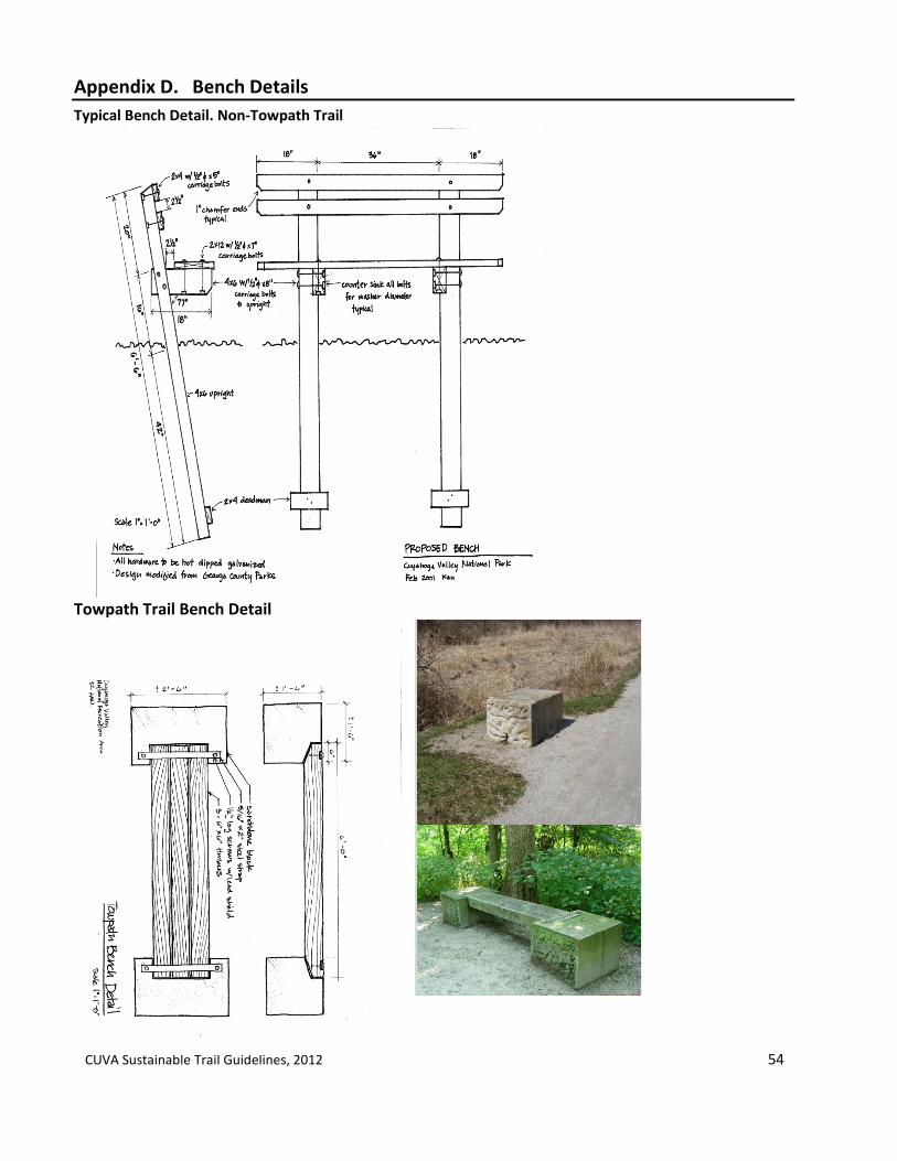
CUVA Sustainable Trail Guidelines, 2012 54
Appendix D. Bench Details
Typical Bench Detail. Non-Towpath Trail
Towpath Trail Bench Detail
CUVA Sustainable Trail Guidelines, 2012 55
Appendix E. Accessible Trails Design Guidelines
It is the goal of the NPS to ensure that all people have the highest level of accessibility that is reasonable to our programs, facilities and services in conformance with applicable regulations and standards as outlined in Director’s Order #42: Accessibility for Visitors with Disabilities in National Park Service Programs and Services. This section sets forth guidance on accessibility and mobility for Cuyahoga Valley National Park’s trails and trail facilities. This section includes four parts; applicable laws and standards, accessibility guidance for outdoor developed areas, guidance for use of other powered mobility devices, and guidance for future share used path accessibility. All of these parts will be part of the evaluation throughout site planning, design, construction and management of all trails and trail facilities by park staff.
1.0 Applicable Laws and Standards
Architectural Barriers Act of 1968. (P.L. 90-480) requires all buildings and facilities built or renovated in whole or in part with Federal funds to be accessible to, and usable by, physically disabled persons. Architectural Barriers Act Accessibility Standards of 2004 (ABAAS). All new and altered buildings and facilities must be designed and constructed in conformance with these standards. Section 504 of the Rehabilitations Act of 1973. (P.L. 93-112) Section 504 requires program accessibility in all programs, activities, and services provided with Federal dollars. Department of Interior Regulations for Section 504 (29 USC 701). Regulations for implementation of Section 504. American with Disabilities Act of 1990 (ADA). Prohibits discrimination on the basis of disability in all State and Local Government entities (Title II) and Place of Public Accommodation (Title III). (Although Federal government is not covered by ADA, the ADA and its regulations provides guidance to Federal entities as they parallel closely with the requirements for Section 504 of the Rehabilitation Act.) Accessibility guidance for the Park’s trails will adhere to the federal guidelines for access and use of mobility devices. The guidelines will address the following items.
Application of Revised Final Title II Regulations of the American with Disabilities Act of 1990. (42.U.S.C 12131)
Application of the proposed and final rule of the Federal Accessibility Guidelines for Outdoor Developed Areas
Utilization of Universal Trail Access Information Signage System
Future reference to proposed rule on Shared Use Path Accessibility Guidelines.
CUVA Sustainable Trail Guidelines, 2012 56
2.0 Draft Accessibility Guidelines for Outdoor Developed Areas The United States Access Board is developing accessibility guidelines, “pursuant to the Architectural Barriers Act (ABA) for camping facilities, picnic facilities, viewing areas, outdoor recreation access routes, trails and beach access routes.” (United States Access Board, 2010) The guidelines would apply to Federal land management agencies, including facilities of the National Park Service that are constructed or altered by or on behalf of the Federal government. The Park will adhere to the Interim Proposed Rule of the Accessibility Guidelines for Outdoor Developed Areas upon rulemaking for all new and altered trails, campsites, paddle launch areas, and other applicable trail facilities. During the Park’s design process, evaluation and determination of accessibility for trails and outdoor trail facilities applicable to the Park will be conducted by the landscape architect/designer of the project. The Park will evaluate each new trail and designate existing trails utilizing the provisions and conditions set forth by the United States Access Board and outlined in this part (2.1, 2.2, 2.3). Due to the unique nature and conditions of each trail, the Park will evaluate each trail individually during the planning and design phases of all new trails or altered existing trails. The evaluation will utilize the Universal Trail Assessment Process (UTAP) where feasible (Universal Trail Assessment Process, FHWA, 2001). Accessibility limitations will be defined for each trail as part of the design development of each new trail and the information provided to the trail and trail facility user. 2.1 General technical provisions of trail accessibility. These provisions for accessibility determination include the following design elements. Design and construction of trails dedicated for universal accessibility and limited accessibility will address these elements at all phases of the implementation process in accordance with the Architectural Barriers Act
- Surface - Clear Tread Width - Openings - Protruding Objects - Tread Obstacles - Passing Space - Slope - Resting Intervals - Edge Protection - Signage
2.1. Adherence to technical provisions for access routes, outdoor recreation access routes and accessible trails. Under the definitions of the Federal Accessibility Guidelines, there are three types of accessible routes; 1) Access routes relate to the built environment where all routes need to meet accessibility requirements, 2) outdoor recreation access routes relate to facilities in the outdoor environment where reasonable access is required, and 3) Accessible trail relates to a natural trail that is designated as suitable for all levels of ability and consistent with conditions that have been set forth by the federal guidelines. (Table 1)

CUVA Sustainable Trail Guidelines, 2012 57
2.3 Conditions for Departure. The Outdoor Developed Areas Draft Final Rule by the United States Access Board has defined four conditions that would allow for departure from the technical provisions in the guidelines. These conditions include;
Where compliance would cause substantial harm to cultural, historic, religious or significant natural features or characteristics.
Where compliance would substantially alter the nature of the setting or the purpose of the facility or portion of the facility.
Where compliance would require construction methods or materials that are prohibited by federal regulations or statutes.
Where compliance would not be feasible due to terrain or prevailing construction practices.
3.0 Application of Revised Final Title II Regulations of the American with Disabilities Act of 1990. (42.U.S.C 12131) for Other Power- driven Mobility Devices
3.1 Regulation Guidance. The rule adopts a two-tiered approach to mobility devices. The Rule defines electronic personal mobility devices that may include a range of devices not designed with mobility impairments. “Wheelchairs (and other devices designed for use by people with mobility impairments) must be permitted in all areas open for pedestrian use. Other power-driven mobility devices must be permitted to be used unless the covered entity can demonstrate that such use would fundamentally alter its programs, services, or activities, create a direct threat, or create a safety hazard.” Definition ADA Part 35.104 Other power driven mobility device. Any mobility device powered by batteries, fuel, or other engines, whether or not designed primarily for use by individuals with mobility disabilities, that is used by individuals with mobility disabilities for the purpose of locomotion, including golf cars, electronic personal assistance mobility devices (EPAMDs), such as the Segway PT, or any mobility device designed to operate in areas without defined pedestrian routes, but that is not a wheelchair within the meaning of this section. Wheelchair means a manually-operated or power-driven device designed primarily for use by an individual with a mobility disability for the main purpose of indoor or of both indoor and outdoor locomotion. 35.130 General prohibitions against discrimination.
(h) A public entity may impose legitimate safety requirements necessary for the safe operation of its services, programs, or activities.
35.137 Mobility devices.
(a) Use of wheelchairs and manually-powered mobility aids. A public entity shall permit individuals with mobility disabilities to use wheelchairs and manually-powered mobility aids in any areas open to pedestrian use.
(b)(1) Use of other power-driven mobility devices (OPDMD). A public entity shall make reasonable modifications in its policies, practice or procedures to permit the use of other power-driven mobility devices by individuals with mobility disabilities unless the public entity can demonstrate that the class of other power-driven mobility devices cannot be operated in accordance with legitimate safety requirements that the public entity has adopted pursuant to 35.130(h).

CUVA Sustainable Trail Guidelines, 2012 58
(b)(2) Assessment Factors In determining whether a particular other power-driven mobility device can be allowed in a specific facility as a reasonable modification (b)(1), a public entity shall consider;
(i) Type, size, weight, dimensions, and speed of the device; (ii) Facility’s volume of pedestrian traffic (which may vary at different times of the day,
week, month or year); (iii) Facility’s design and operational characteristics. (iv) Whether legitimate safety requirements can be established to permit the safe operation other power-driven mobility device in the specific facility; and (v) Whether the use of the other power-drive mobility device creates a substantial risk of
serious harm to the immediate environment or natural or cultural resources, or poses a conflict with Federal land management laws and regulations.
3.2 Cuyahoga Valley National Park Mobility Device Guidance. The trails in Cuyahoga Valley National Park provide a wide range of conditions for trail accessibility and mobility. For the purpose of the mobility assessment, this section addresses the use of other power-drive mobility devices (OPDMD) in the Park. Accessibility Guidance for OPDMDs includes trails with limitations for access, permitted use of OPDMD’s, and limitations of OPDMD’s on permitted trails.
Use of OPDMD’s. All trails have opportunities for accessibility. Accessibility for OPDMD’s on trails are designated on all multi-use trails. Additional permitted or restricted use of OPDMD’s on CVNP trails will be administered by the Superintendent through the adherence of the ADA mobility guidance (35.137(b)(2)). Assessment factors of the ADA mobility guidance (35.137 (b)(2)) that determine the use of OPDMD’s on all designated trails in the park include:
Facility’s volume of trail traffic (which may vary at different times of the day, week, month or year); and the volume and variety of uses (bike, hike, equestrian) have existing issues of congestion and user conflicts during peak visitor use periods and summer events. Use of OPDMD will require additional tread width to accommodate use. Additional tread width will not meet the trail development standards for trails other than multi-use trails set forth in these Trail Guidelines.
Facility’s design and operational characteristics. The width and surface of the other trails in the park that are not multi-purpose are less than 36” and contain natural terrain with slopes which may exceed 5% . Natural resource conditions and protection of park resources limits the expansion and design modifications for use by OPDMDs.
Whether the use of the other power-driven mobility device creates a substantial risk of serious harm to the immediate environment or natural or cultural resources, or poses a conflict with Federal land management laws and regulations. The Park’s trail surfaces predominantly are of natural or gravel materials. Increased weight on these surfaces may increase erosion, rutting and widening of existing trails that would increase environmental and operational impacts to the current or proposed trails. Additionally, because of the trail terrain, substantial infrastructure would be required to accommodate OPMD’s on the natural surface trails in the Park.

CUVA Sustainable Trail Guidelines, 2012 59
Permit Use of OPDMD. The Park may allow for OPDMD’s in areas prohibited where special conditions apply and use can be safe, operable and prevents environmental, cultural or safety impacts to park resources. Permission of these uses would be administered by the Superintendent’s office. Limitations of OPDMD’s on multi-use trails in CVNP. Use of OPDMD is permissible on the Towpath Trail, Hale Farm Connector, Old Carriage Connector and any future multi-use trails that meet grade and surface requirements. The use of OPDMD’s are allowable by people with disabilities on multi-use trails within CVNP under these conditions.
No internal combustion engines permitted.
Electric-powered devices designed to transport a single individual with a disability as a substitute for walking use by a person with a mobility disability. Establish a speed limit for accessibility devices, not to exceed 5 miles per hour. Mobility devices no wider than 36” are permitted. Pedestrian and bicycle use on the Towpath during average peak season weekends can average
up to 200-400 users during a two-hour period at a single location. (Proper Ref: NPS 2011) 2010-2011 Trail User Count). User capacity and safety will need to be monitored in respect to the use of OPMD’s and modified accordingly. Because of the trail’s physical design prescribed by its cultural significance and physical location along the Cuyahoga River and Ohio & Erie Canal Corridor, the Towpath Trail is limited for modification.
The Towpath Trail width is limited to its placement between the Cuyahoga River and the Ohio & Erie Canal to accommodate additional tread width. This factor may limit the utilization of other power-driven personal mobility devices during peak visitor use periods (summer, special events).
4. 0 Shared Use Path Accessibility Guidelines The U.S. Access Board has issued a notice of proposed rulemaking to develop accessibility guidelines for shared-use paths. As defined under the proposed rule, the rule shared use paths are “primarily designed for bicyclists and others for transportation purposes such as commuting to work.” Under this definition, the proposed rule would only apply potentially to the Towpath Trail, the Bike and Hike Trail and any new multi-purpose trail that would be connected to the Towpath or Bike and Hike for any new construction or alteration of the shared use paths. The Park will continue to review the proposed guidelines and their application upon any new construction or alteration of the shared-use paths that are defined and apply under this proposed rule.

CUVA Sustainable Trail Guidelines, 2012 60
Table 1. Access Route Guidance (Source: United States Access Board, Draft Accessibility Guidelines for Outdoor Developed Areas)
TECHINICAL PROVISION FOR ACCESS ROUTES, OUTDOOR ACCESS ROUTES AND ACCESSIBLE ROUTES
Access Route (ADAAG) Outdoor Access Route Accessible Trail
Surface Stable, firm, and slip resistant Firm and stable Firm and stable (exception)*
Maximum Running Slope
1:12 (8.33%) 1:20 (5%) (for any distance) 1:12 (8.33%) (for max. 50 ft) 1:10 (10%) (for max. 30 ft.)
1:20 (5%) (for any distance) 1:12 (8.33%) (for max. 50 ft. ) 1:10 (10%) (for max. 30 ft.) 1:8 (12.5%) (for max. 10 ft) (Exception: 1:7 (14.3%) for 5 feet maximum for open drainage structures when * applies)
Maximum Cross-Slope
1:50 (2%) 1:33 (3.03%) (Exception: 1:20 (5%) for drainage purposes)
1:20 (5%) (Exception: 1:10 (10%) at the bottom of an open drain where clear tread width is a minimum of 42 inches.)
Minimum Clear Tread Width
36 inches 32 inches for no more than 24 inches
36 inches (Exception 32 inches when * applies)
36 inches (Exception: 32 inches when * applies)
Tread Obstacles
Changes in level: ¼ inch with no beveled edge, 1/4 – ½ inch must have a beveled edge with a max slope of 1:2 (50%) (over ½ inch = ramp)
1 inch high maximum (Exception: 2 inches high maximum where beveled with a slope no greater than 1:2 (50%) and where * applies.)
2 inches high maximum. (Exception: 3 inches maximum where running and cross slopes are 1:20 (5%) or less. (Exception *)
Passing Space Every 200 feet where clear tread width is less than 60 inches, a minimum 60 x 60 inch space, or a T-shaped intersection of two walks or corridors with arms and stem extending minimum of 48 inches.
Every 200 feet where clear tread width is less than 60 inches, a minimum 60 x 60 inch space, or a T-shaped intersection of two walks or corridors with arms and stem extending minimum of 48 inches. (Exception: Every 300 feet where * applies.)
Every 1000 feet where clear tread width is less than 60 inches, a minimum 60 x 60 inch space, or a T-shaped intersection of two walks or corridors with arms and stem extending minimum of 48 inches. (Exception: *)
Resting Intervals
Landings: 60 inch min length, minimum width as wide as the ramp run leading to it, if change in direction occurs, much have 60 x 60 inch space.
60 inches minimum length, width at least as wide as the widest portion of the trail segment leading to the resting interval and a max slope of 1:33 (3.03%) (Exception: A max slope of 1:20 (5%) is allowed for drainage purposes.
60 inches minimum length, width, at least as wide as the widest portion of the trail segment leading to the resting interval and a max slope of 1:20 (5%) (Exception *)
*The provision may not apply if it cannot be provided because compliance would cause substantial harm to cultural, historic, religious or significant natural features or characteristics; substantially alter the nature of the setting or purpose of the facility: require construction methods or materials that are prohibited by Federal, state, or local regulations or statues; or be infeasible due to terrain or the prevailing construction practices.

CUVA Sustainable Trail Guidelines, 2012 61
Appendix F. Bridge Structure Guidance
Structure Categories
Definitions Inspector Requirements
1. Complex
Bridge
Complex Trail Bridges: All steel truss, suspension and concrete span bridges requiring skilled labor, engineering and cranes for installation. Bridges are contracted for design, engineering and installation. Examples: Old Carriage Trail bridges, pedestrian bridges over Cuyahoga, Towpath steel truss bridges
Requires Contracting Officer Technical Representative to oversee project installation. Bridges to be inspected annually by Federal Highway Inspection Team with other road bridges in park.
2. Major Trail
Bridge
Major Trail Bridges: All bridges more than 24 feet. Including fiberglass bridges installed with volunteers and multi-span wooden bridges. Examples: Brandywine Gorge Bridge & Stanford fiberglass bridge, Ledges & Haskell Run 30’ wooden bridges
Condition assessment by NPS personnel
3. Minor Trail
Bridge
Minor Trail Bridges: All single span wooden bridges and boardwalks spanning up to 24’ long.
Condition assessment by NPS personnel

CUVA Sustainable Trail Guidelines, 2012 62
Appendix G. General Trail Condition Management System
This decision matrix provides a general overview of park procedures for determining trail operating levels.
NEPA Environmental Screening Form -
Trail Condition
Assessment & Inventory
Trail Count Information
Trail Carrying Capacity
Guidelines
1----
-
1----
Muddy Conditions
Erosion
Plant& Animal
Sensitivity
1-------l Infrastructure
Visitor Use
Cultural
Conditions do not exceed
resource, safety and visitor
capacity condlf.- tions temporar
ily or during a season annually.
Full Operating Trail remain
opens. Repairs and management actions to restore
area occur.
Seasonal/ Temporary
Conditions Closure
f.-
exceed Set conditions
resource, safety for use. Repair and visitor t-------1 and management
capacity condi- actions to restore
tions tempo- occur.
rarlly or during a season annually.
Conditions exceed
resource, safety and visitor
capacity conditions annually.
Permanent Closure
Realignment is reviewed.
Restoration and management
Plan is developed for trail closure.
Resources 1-1

C
UV
A Su
stainab
le Trail Gu
idelin
es, 2
01
2 63
Ap
pen
dix H
. Visito
r Carryin
g Cap
acity for O
utd
oo
r Re
creation
and
Facilities
Topic User Capacity User Capacity Standard Monitoring Strategies Potential Management Strategies Indicators
Trails Number of users per No more than _ people at one Periodic monitoring of trail 1. Education of Users. day. t ime (PACT) in a two hour period. use of select trail segments by 2. Reallocation of users (permit , use
- corridor trail park staff and volunteers. limits) _ Interpretive t rail 3. Enforcement of use _ equestrian trail 4. Trail Closure Operational Guidance
- XC Ski trail 5. Redesign of Trail _hiking t rai l 6. Increased management of Trail _ primit ive hiking trail
mountain bike trail ••• -(if determined in selected alternative)
Number of incidents Exceeds _ incidents in any given Reported incidents by Visitor t hat occur per month during a 12-month period. Protection Division. mont h.
Mean trail w idth of Mean trail width does not exceed Point sampling method as designated t rail class 10% designated trail design developed and implemented design standard. standard/ baseline. by Inventory and Monitoring
Program.
Level of damage to Trail tread exceeds Sustainable Point sampling method as trail resulting in Trail Guidelines for muddiness developed and implemented muddy conditions. and wet condit ions. by Inventory and Monitoring
Program. Campsites Number of permits Camping sites full all weekends Camping permits during 1. Education of Users.
per day. during camping season {May seasonal weekends. 2. Reallocation of users (permit , use through October) limits)
Vegetation loss method as 3. Enforcement of use Area of Vegetation No more than _ square feet of developed and implemented 4. Campsite Operational Guidance loss within proximity vegetat ion loss by Inventory and Monitoring of campsite. Program based upon
landscape types.

C
UV
A Su
stainab
le Trail Gu
idelin
es, 2
01
2 64
Topic I User Capacity User Capacity Standard I Monitoring Strategies Potential Management Strategies Indicators
River Recreational Number of Does not exceed - PeriocfJC sampling of 1. Education of Users. Water Trail Use canoes/kayaks on canoes/kayaks in the river at kayaks/ canoes on River during 2. ReaUocation of users (permit, use
Cuyahoga River selected sites sampled mid-week, peak season average use. limits) measured at weekends, holiday weekends and
I 3. Enforcement of use
selected sites and weeks fol lowing holidays during I 4. River Use Operational Guidance times.. peak periods.
Number of boating Does not exceed _ boating use Count number of boating use use permits per per permits per an annual season permits per week during boat season. from May through October use season.
Number of users at Does not exceed - users at Periodic sampling of users of launch sites. launch site sampled mid_.eek, launch sites.
weekends, holiday weekends, and
I
weeks following holidays during peak periods. I
Number of boat Does not exceed - users at Report number of boat incidents per launch incidents per season by Visitor season. Protection Division.
I 1. Education of Users. Number of days Count number of days 2. ReaDocation of users {permit, use exceeding primary exceeding primary recreation limits) recreation water water quality standards. 3. Enforcement of use quality standards. I 4. River Use Operational Guidance
I Resource Impacts
Parking Amount of time A parking lot is fuU _ hours per Amount of time parking lot is I 1. Increased ma.nagement of parking lots partcing lots are fuD week. full through parking lot counts to redirect visitors to less used lots by {all spaces full) near during average peak days. park staff. trailheads. 2. Expand or redesign existing parking
Count number of times a lots to accommodate more vehicles.
I parking lot is full during 3. Construct new parking lots. average peak days. 4. Pursue shared-off-site parking. L Number of times A parking lot is fuD _ per week or
I partcing lots are fuD. times per month.

CUVA Sustainable Trail Guidelines, 2012 65
Appendix I. Trail Event Sustainability Use Permit Application Checklist
(to be developed as part of initial implementation phase of Trail Plan)

CUVA Sustainable Trail Guidelines, 2012 66
Appendix J: Trail Condition Report
Trail: Date: Inspector(s): Note. Condition assessments need to be done by experienced trail personnel.
Use this form to log deficiencies with the trail. Consult the Trail Feature Guide to see the location and the expected condition of signs and structures along the trail. Describe problems and record notes in the margins. Check the box “ at the beginning of each section if no problems are found in that section. OK 2. Signs and Wayside Exhibits
Observe conditions and report problems. Note sign number.
Trail Name: ______________________
Structures: bridges, boardwalks, puncheons, turnpikes, steps, benches, fencing Observe conditions and report problems with: 4.1 Bridges and boardwalks hrough 4.2 Puncheons Foundation sill 4.3 Turnpikes – – needs replacement – Replacement
Step
Length needing replaced/repaired? LF
Horse/ hiking trails – 3 to 5 feet wide Observe conditions of the treadway and report problems:

CUVA Sustainable Trail Guidelines, 2012 67
Appendix J. Continued. Average Treadway width __________LF Estimate size: __________SF Estimate size: _____________LF
Trail Name: _____________________________ Date: _____________________________
– ditches, culverts, grade reversals, waterbars
7.1 Ditches If No, estimate length of clogged drain ditch: LF 7.2 Culverts If No, diameter and length of culvert? 7.3 Drain dips and 7.4 Waterbars

CUVA Sustainable Trail Guidelines, 2012 68
Appendix K. Trail Resource Condition Assessment Worksheet
(To be developed as part of implementation of Trail Plan)

CUVA Sustainable Trail Guidelines, 2012 69
Appendix L. Trail Count Worksheet
Staff:______________________________________ Location:___________________________________ Date & Time:________________________________ Weather:____________________________________ Comments/Notes
Types of users:
Totals:
Bike:
Foot: (walker, runner)
Dogs:
Horse:
Other: (Strollers, Wheelchair, Bike attachments...etc)

CUVA Sustainable Trail Guidelines, 2012 70
Appendix M. Parking Lot Count Worksheet
Staff:_________________________ Date:_________________________ Weather:______________________ Comments:
Parking Lots Time # of Cars # of Horse
Trailers
# of Spaces
1st
2nd
1st
2nd
1st
2nd
Rockside 101 (9 ACC) + 114 stab turf + 5 buses
Lock 39 42 (2 ACC)
Canal V.C 92 (4 ACC)
Terra Vista 8 gravel/asphalt
Fitzwater 20 (1 ACC)
Frazee House 9 (1 ACC)
Station Road Bridge 134 (6 ACC) +15 pull thru
Jaite Wayside 14 gravel
Red Lock 16 (1 ACC)
Brandywine Falls 90 (4 ACC)
Stanford House 9 gravel
Boston Store 45 (2 ACC)
Boston Overflow 8 + 5 pull thru gravel
Bike & Hike 9
Blue Hen Falls 3 main lot gravel + 12 overflow grass
Lock 29 43 (2 ACC)
Lock 29 Overflow 85 gravel
Pine Lane 12 gravel
Happy Days N 108 (0 ACC)
Happy Days S 14 (4 ACC)6 acc
VK Lake 190 (5 ACC) 6 acc

CUVA Sustainable Trail Guidelines, 2012 71
Parking Lots Time # of Cars # of Horse
Trailers
# of Spaces
Octagon 104 (6 ACC)
Ledges 223 (8 ACC)
Pine Hollow 203 (9 ACC)
Crow Foot Gully 63 (4 ACC)
Little Meadow 62 (4ACC)
Wetmore 18 +10 pull thru gravel
Horseshoe Pond 20 (2 ACC)
Oak Hill 85 gravel
Everett Covered Bridge
40 gravel
Hunt Farm 40 (2 ACC)
Indigo Lake 12 gravel
Ira 47 (2 ACC)
Botzum 127 (6ACC)
CUVA Sustainable Trail Guidelines, 2012 72
References:
American Association of State Highway and Transportation Officials, 1999. Guide for the Development of Bicycle Facilities. Bakaletz S., Linder W., 2009. Mussels Protected from horses at Big South Fork. Park Science. Volume 26, Number 2. Bates T., 2010. “Supertiny Power Plants”, Fast Company, June, Issue 146.
http://www.fastcompany.com/magazine/146/supertiny-power-plants.html Beers, Don. 2009. Trail management: plans, projects and people. National interagency training course. August 3-7, 2009. Homer, AK. Unpublished PowerPoint presentation. Beneficial Designs. 2012 Universal Trail Assessment Process, http://www.beneficialdesigns.com/trails/utap.html#Summary Federal Highway Administration, 2001. Designing Sidewalks and Trails for Access, Chapter 13, Universal Trail Assessment Process. http://www.fhwa.dot.gov/environment/sidewalk2/index.htm Flink, C., Olka, K., Searns, R. 2001. Trails for the 21st Century. International Mountain Bike Association, 2004. Trail Solutions. International Mountain Bike Association. 2007. Managing Mountain Biking, International Mountain Bike Association. Kusler, J. 2006. Constructing Wetland Boardwalks and Trails. Association of State Wetland Managers, Inc, International Institute for Wetland Science and Public Policy, 2006 Macdonald. S. Policies address trail accessibility rule on Power-Driven Mobility Devices, American Trails Magazine. Marion J., Leung. Nepal. 2006. Monitoring Trail Conditions, New Methodological Considerations, George Wright Forum, Volume 23, Number 2. Minnesota Department of Natural Resources, 2006. Trail Planning, Design and Development Guidelines. National Park Service, U.S. Department of Interior 2001. CVNP Trail Standards. Cuyahoga Valley National Park. 2003. A Census of Hiking Trail use in Acadia National Park, August 5 and 6, 2003. 2008. CVNP Trail Construction Guidelines, Cuyahoga Valley National Park. 2007. Guide to Sustainable Mountain Trails. Trail Assessment, Planning & Design Sketchbook.

CUVA Sustainable Trail Guidelines, 2012 73
2008. Sign Plan, Cuyahoga Valley National Park. 2009a. NPS Project Sustainability Checklist, Building and Non Building Projects (for new construction and renovation. 2009b. Trail Management Plan and Environmental Assessment. Saguaro National Park. 2009c. Trail Monitoring Manual, Mammoth Cave National Park. 2011. New River Gorge National Recreation Area, Design and Build Stacked Loop Hiking and Biking Trail Systems, Environmental Assessment. 2011. NPS Climate Friendly Program Guidance. 2012. Sustainability of National Park Service Backcountry Trails, Minimizing Resource Impacts New York City Department of Parks and Recreation and Design Trust for Public Space, 2010. High Performance Landscape Design Guidelines. Portland Parks and Recreation. 2009. Trail Design Guidelines, Portland’s Trail System, Portland Parks & Recreation. State of Ohio Department of Transportation, 2002. Construction and Material Specifications.
Sustainable Sites Initiative: Guidelines and Performance Benchmarks, 2009. www.sustainablesites.org/report U.S. Access Board. October, 2009. Draft Final Accessibility Guidelines for Outdoor Developed Areas. U.S. Access Board. 2011. Notice on Shared Use Path Accessibility Guidelines, U.S. Federal Register, U.S. Access Board, 3/28/2011 http://www.federalregister.gov/articles/2011/03/28/2011-7156/shared-use-path-accessibility-guidelines U.S. Department of Justice. 2010. Revised Final Title II Regulations of the Americans with Disabilities Act of 1990 (42.U.S.C. 12131, Department of Justice). U.S. Forest Service. 2004. Trail Planning and Management Fundamentals. U.S. Forest Service. 2005. National Trail Management Classes and Design Parameters U.S. Forest Service, 2008. Trail Assessment & Condition Surveys, User Guide. U.S. Forest Service, 2008. Trails Handbook. Wood, 2007. Recreational Horse Trails in Rural and Wildland Areas.