Embed Size (px)
Citation preview
Abstract—Cisadane watersheds is a very valuable strategic
area for the people in Tangerang District, Banten, Indonesia.
But that strategic value has brings an impact in the form of
water pollution, that comes from its popullation and economic
activities. This water pollution load is necessary to know its
source, and also how much, so that public, private and local
governments can jointly take action to restore the water quality
of the Cidasane River. The purpose of this study is to determine
the pollution load in the Cidasane watersheds. The study will
taking sample of Cisadane River water as an inputs in the isoyet
map pollution dispersion modeling. And calculating the load in
the river using QUAL2Kw modelling. The results of the
modeling are then analyzed to obtain the amount of Cisadane
River pollutant load. The pollution load in this study will be
focused on BOD, NO3, and Total P, and Salinity. This research
has shown the inter-regional pollution spread on the Cisadane
river, which used This study will provide a measurable data of
the type and scale of the pollution load in Cisadane, as an input
for Cisadane River water quality restoration policy making by
the Government of Tangerang.
Index Terms—Cisadane river, Isoyet map, pollution load,
QUAL2Kw model, sustainable watersheds.
I. INTRODUCTION
Nature constantly changes, however human have not
always adapted to such changes. Even when such changes
have been triggered by the human themselves. River is one of
the form of nature environment which in this case has
undergone rapid changes.
Cisadane River is one of the major rivers in Java Island
which flows 114 km passing several regencies and
municipalities specifically Bogor Regency, Bogor
Municipality, Tangerang Regency, South Tangerang
Municipality, and Tangerang Municipality and ultimately
enters the Java Sea. Cisadane River Watershed is the home of
approximately 1.7 millions people. It serves as the source of
clean water for agriculture, animal husbandry, industries, and
raw water supply for PDAM (regional water utility company).
However, due to years of pollution, water quality of Cisadane
River today has been declared as severely polluted [1].
The purpose of this study is to comprehend the pollution of
Cisadane River in conjunction with the efforts to prepare
pollution mitigation strategies based on the principle of
Manuscript received October 30, 2016; revised December 30, 2016.
The authors are with the Universitas Indonesia, Jakarta, Indonesia (e-mail:
[email protected], [email protected], [email protected],
[email protected], [email protected]).
sustainability along Cisadane Watershed.
II. METHODS
Cisadane River is one of the major rivers in Java Island in
which the lower end meets the tidal at the northern coast of
Java Island. The upstream region of the Cisadane River is
situated at the slope of Mount Pangrango with a number of
tributaries which are originated in Mount Salak.
Geographically, Cisadana Watershed is situated between
6º02’ S to 6º54’ S and 106º17’ E [2].
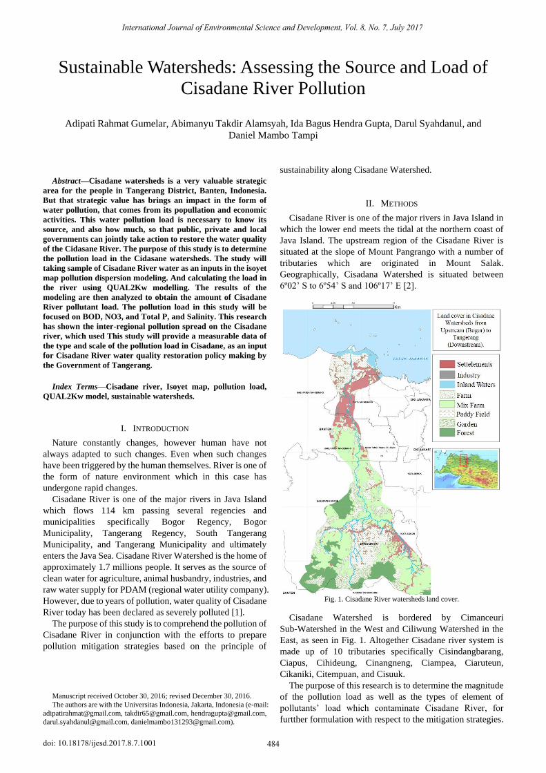
Fig. 1. Cisadane River watersheds land cover.
Cisadane Watershed is bordered by Cimanceuri
Sub-Watershed in the West and Ciliwung Watershed in the
East, as seen in Fig. 1. Altogether Cisadane river system is
made up of 10 tributaries specifically Cisindangbarang,
Ciapus, Cihideung, Cinangneng, Ciampea, Ciaruteun,
Cikaniki, Citempuan, and Cisuuk.
The purpose of this research is to determine the magnitude
of the pollution load as well as the types of element of
pollutants’ load which contaminate Cisadane River, for
furtther formulation with respect to the mitigation strategies.
Sustainable Watersheds: Assessing the Source and Load of
Cisadane River Pollution
Adipati Rahmat Gumelar, Abimanyu Takdir Alamsyah, Ida Bagus Hendra Gupta, Darul Syahdanul, and
Daniel Mambo Tampi
International Journal of Environmental Science and Development, Vol. 8, No. 7, July 2017
484doi: 10.18178/ijesd.2017.8.7.1001
Modelling of land pollution load transported to the Cisadane
River will rely on QUAL2Kw method. QUAL2Kw is a
simulation framework of water quality in the river by
applying the approach of single dimension flow type through
steady pattern [3].
Primary data for QUAL2Kw method will be acquired
through field survey in the estuary of Cisadane River. Such
data will be used as an input to the isohyet map modelling on
the pollution distribution in Cisadane River as well as load
calculation modelling in the river using QUAL2Kw
application. The result of such modelling will then be
analyzed to determine the extent of pollutant load in
Cisadane River. Pollutant load assessed on this research will
be focused on BOD, NO3, and Total P elements.
Literature study with respect to the continuity of the
Watershed management is undertaken to enhance the
knowledge on the research results along with the follow-up
actions or strategies which must be implemented to improve
water quality along the Cisadane River.
III. DISCUSSION AND ANALYSIS
Prior to inputting the data on QUAL2Kw program, the first
step which need to be performed is dividing the river into
different sections in which calculation on the pollutant load
of each section will be carried out. Division into several
sections is carried out in consideration of different physical
characteristics of the river (depth and width) as well as
presence of point sources entering the river. In a QUAL2Kw
modelling, the designation of 0 km point is at the very end of
the downstream region. On this current research, the outset of
the river starts at the downstream region situated in Muara
Jaya Village (Bogor Regency) down to Teluk Naga
Subdistrict (Tangerang Regency).
A. Cisadane River Water Quality
On a pollutant load modelling, all data of pollutant load
were input into the QUAL2Kw application to acquire the
accumulation of pollutant load on each segment of the river.
Source of pollutants consist of domestic and industrial wastes.
Calculation of industrial waste is based on discharge data and
quality of industrial wastes which discharge their effluent
wastes to Cisadane River.
In addition to the simulation of pollutant load, data of
water usage along the Cisadane River have also been input.
The use of this water will reduce river water discharge and
thus affect the amount of pollutant concentration in the river.
Parameters of water quality testd include among other
BOD, NO3, and Total P.
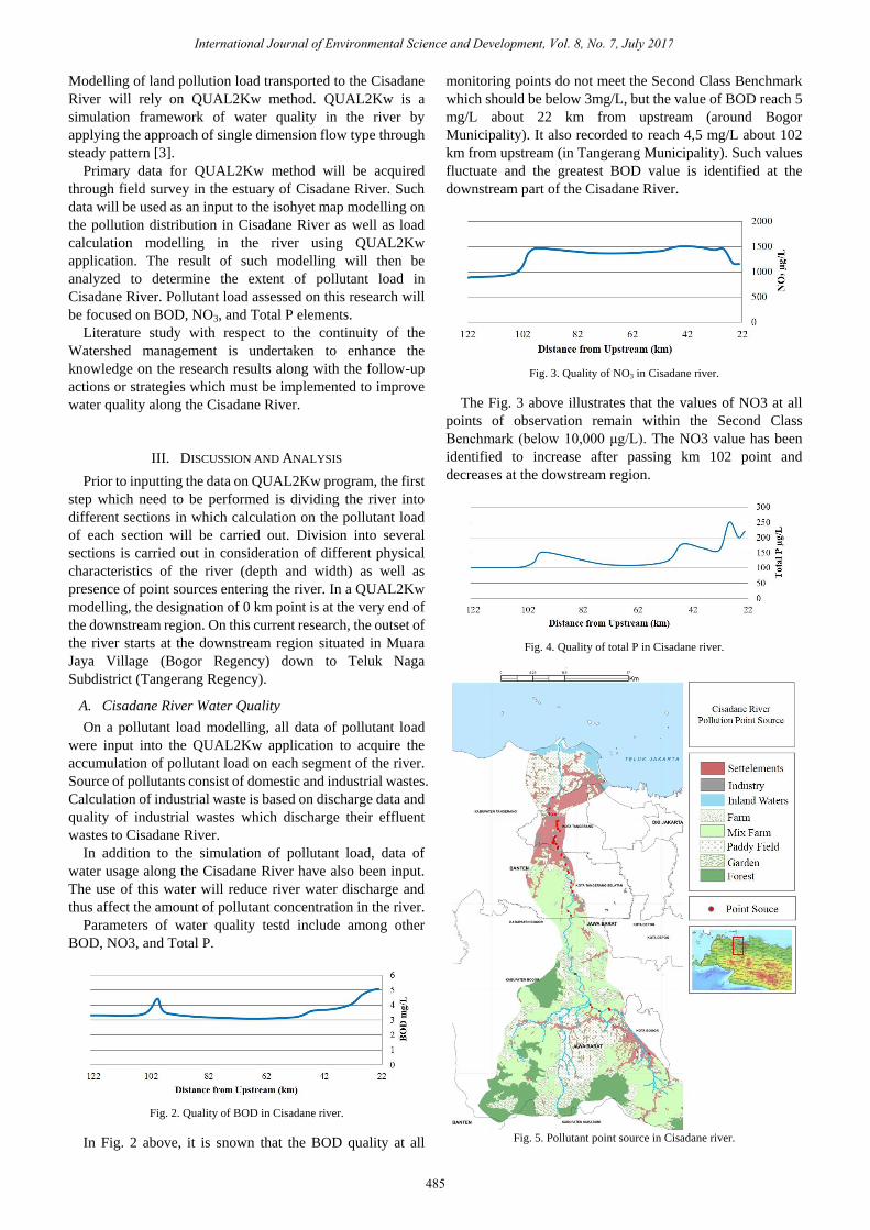
Fig. 2. Quality of BOD in Cisadane river.
In Fig. 2 above, it is snown that the BOD quality at all
monitoring points do not meet the Second Class Benchmark
which should be below 3mg/L, but the value of BOD reach 5
mg/L about 22 km from upstream (around Bogor
Municipality). It also recorded to reach 4,5 mg/L about 102
km from upstream (in Tangerang Municipality). Such values
fluctuate and the greatest BOD value is identified at the
downstream part of the Cisadane River.
Fig. 3. Quality of NO3 in Cisadane river.
The Fig. 3 above illustrates that the values of NO3 at all
points of observation remain within the Second Class
Benchmark (below 10,000 μg/L). The NO3 value has been
identified to increase after passing km 102 point and
decreases at the dowstream region.
Fig. 4. Quality of total P in Cisadane river.
Fig. 5. Pollutant point source in Cisadane river.
International Journal of Environmental Science and Development, Vol. 8, No. 7, July 2017
485
Meanwhile, Fig. 4 indicates that Total P values in several
observation points meet the Second Class Benchmark which
is 200 μg/L. However, in several points, especially those
leading to the downstream region (Kabupaten Tangerang and
Kota Tangerang), the Total P concentration is greater and
exceeding the benchmark, which is could prove harmful.
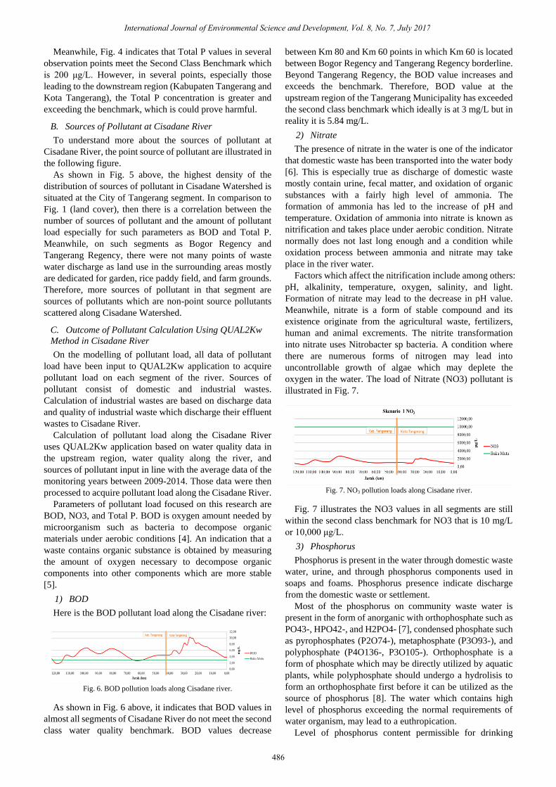
B. Sources of Pollutant at Cisadane River
To understand more about the sources of pollutant at
Cisadane River, the point source of pollutant are illustrated in
the following figure.
As shown in Fig. 5 above, the highest density of the
distribution of sources of pollutant in Cisadane Watershed is
situated at the City of Tangerang segment. In comparison to
Fig. 1 (land cover), then there is a correlation between the
number of sources of pollutant and the amount of pollutant
load especially for such parameters as BOD and Total P.
Meanwhile, on such segments as Bogor Regency and
Tangerang Regency, there were not many points of waste
water discharge as land use in the surrounding areas mostly
are dedicated for garden, rice paddy field, and farm grounds.
Therefore, more sources of pollutant in that segment are
sources of pollutants which are non-point source pollutants
scattered along Cisadane Watershed.
C. Outcome of Pollutant Calculation Using QUAL2Kw
Method in Cisadane River
On the modelling of pollutant load, all data of pollutant
load have been input to QUAL2Kw application to acquire
pollutant load on each segment of the river. Sources of
pollutant consist of domestic and industrial wastes.
Calculation of industrial wastes are based on discharge data
and quality of industrial waste which discharge their effluent
wastes to Cisadane River.
Calculation of pollutant load along the Cisadane River
uses QUAL2Kw application based on water quality data in
the upstream region, water quality along the river, and
sources of pollutant input in line with the average data of the
monitoring years between 2009-2014. Those data were then
processed to acquire pollutant load along the Cisadane River.
Parameters of pollutant load focused on this research are
BOD, NO3, and Total P. BOD is oxygen amount needed by
microorganism such as bacteria to decompose organic
materials under aerobic conditions [4]. An indication that a
waste contains organic substance is obtained by measuring
the amount of oxygen necessary to decompose organic
components into other components which are more stable
[5].
1) BOD
Here is the BOD pollutant load along the Cisadane river:
Fig. 6. BOD pollution loads along Cisadane river.
As shown in Fig. 6 above, it indicates that BOD values in
almost all segments of Cisadane River do not meet the second
class water quality benchmark. BOD values decrease
between Km 80 and Km 60 points in which Km 60 is located
between Bogor Regency and Tangerang Regency borderline.
Beyond Tangerang Regency, the BOD value increases and
exceeds the benchmark. Therefore, BOD value at the
upstream region of the Tangerang Municipality has exceeded
the second class benchmark which ideally is at 3 mg/L but in
reality it is 5.84 mg/L.
2) Nitrate
The presence of nitrate in the water is one of the indicator
that domestic waste has been transported into the water body
[6]. This is especially true as discharge of domestic waste
mostly contain urine, fecal matter, and oxidation of organic
substances with a fairly high level of ammonia. The
formation of ammonia has led to the increase of pH and
temperature. Oxidation of ammonia into nitrate is known as
nitrification and takes place under aerobic condition. Nitrate
normally does not last long enough and a condition while
oxidation process between ammonia and nitrate may take
place in the river water.
Factors which affect the nitrification include among others:
pH, alkalinity, temperature, oxygen, salinity, and light.
Formation of nitrate may lead to the decrease in pH value.
Meanwhile, nitrate is a form of stable compound and its
existence originate from the agricultural waste, fertilizers,
human and animal excrements. The nitrite transformation
into nitrate uses Nitrobacter sp bacteria. A condition where
there are numerous forms of nitrogen may lead into
uncontrollable growth of algae which may deplete the
oxygen in the water. The load of Nitrate (NO3) pollutant is
illustrated in Fig. 7.
Fig. 7. NO3 pollution loads along Cisadane river.
Fig. 7 illustrates the NO3 values in all segments are still
within the second class benchmark for NO3 that is 10 mg/L
or 10,000 μg/L.
3) Phosphorus
Phosphorus is present in the water through domestic waste
water, urine, and through phosphorus components used in
soaps and foams. Phosphorus presence indicate discharge
from the domestic waste or settlement.
Most of the phosphorus on community waste water is
present in the form of anorganic with orthophosphate such as
PO43-, HPO42-, and H2PO4- [7], condensed phosphate such
as pyrophosphates (P2O74-), metaphosphate (P3O93-), and
polyphosphate (P4O136-, P3O105-). Orthophosphate is a
form of phosphate which may be directly utilized by aquatic
plants, while polyphosphate should undergo a hydrolisis to
form an orthophosphate first before it can be utilized as the
source of phosphorus [8]. The water which contains high
level of phosphorus exceeding the normal requirements of
water organism, may lead to a euthropication.
Level of phosphorus content permissible for drinking
International Journal of Environmental Science and Development, Vol. 8, No. 7, July 2017
486
water purposes is 0.2 mg/Liter in the form of phosphate
(PO4). Meanwhile level of phosphorus in a natural water
ranges between 0.005-0.02 mg/L in the form of PO4 [9]. The
amount of Phosphorus pollutant load is presented in the
following graph:
Fig. 8. PO4 pollution loads along Cisadane river.
Furthermore, As shown in Fig. 8 above indicates that Total
P values consistently meet the second class benchmark
starting from the upstream region at km 32 point which is the
borderline between Tangerang Regency and Tangerang
Municipality. Meanwhile starting from km 32 point down to
km 2 the Total P values exceed the second class benchmark
and once again restore the values back to meeting the
benchmark at km 0 point in downstream area of Cisadane
River.
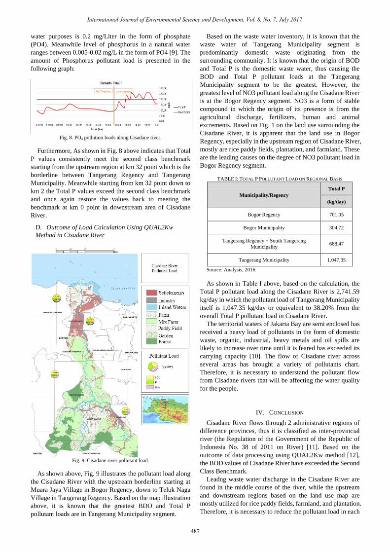
D. Outcome of Load Calculation Using QUAL2Kw
Method in Cisadane River
Fig. 9. Cisadane river pollutant load.
As shown above, Fig. 9 illustrates the pollutant load along
the Cisadane River with the upstream borderline starting at
Muara Jaya Village in Bogor Regency, down to Teluk Naga
Village in Tangerang Regency. Based on the map illustration
above, it is known that the greatest BDO and Total P
pollutant loads are in Tangerang Municipality segment.
Based on the waste water inventory, it is known that the
waste water of Tangerang Municipality segment is
predominantly domestic waste originating from the
surrounding community. It is known that the origin of BOD
and Total P is the domestic waste water, thus causing the
BOD and Total P pollutant loads at the Tangerang
Municipality segment to be the greatest. However, the
greatest level of NO3 pollutant load along the Cisadane River
is at the Bogor Regency segment. NO3 is a form of stable
compound in which the origin of its presence is from the
agricultural discharge, fertilizers, human and animal
excrements. Based on Fig. 1 on the land use surrounding the
Cisadane River, it is apparent that the land use in Bogor
Regency, especially in the upstream region of Cisadane River,
mostly are rice paddy fields, plantation, and farmland. These
are the leading causes on the degree of NO3 pollutant load in
Bogor Regency segment.
TABLE I: TOTAL P POLLUTANT LOAD ON REGIONAL BASIS
Municipality/Regency
Total P
(kg/day)
Bogor Regency 701.05
Bogor Municipality 304,72
Tangerang Regency + South Tangerang
Municipality 688,47
Tangerang Municipality 1.047,35
Source: Analysis, 2016
As shown in Table I above, based on the calculation, the
Total P pollutant load along the Cisadane River is 2,741.59
kg/day in which the pollutant load of Tangerang Municipality
itself is 1,047.35 kg/day or equivalent to 38.20% from the
overall Total P pollutant load in Cisadane River.
The territorial waters of Jakarta Bay are semi enclosed has
received a heavy load of pollutants in the form of domestic
waste, organic, industrial, heavy metals and oil spills are
likely to increase over time until it is feared has exceeded its
carrying capacity [10]. The flow of Cisadane river across
several areas has brought a variety of pollutants chart.
Therefore, it is necessary to understand the pollutant flow
from Cisadane rivers that will be affecting the water quality
for the people.
IV. CONCLUSION
Cisadane River flows through 2 administrative regions of
difference provinces, thus it is classified as inter-provincial
river (the Regulation of the Government of the Republic of
Indonesia No. 38 of 2011 on River) [11]. Based on the
outcome of data processing using QUAL2Kw method [12],
the BOD values of Cisadane River have exceeded the Second
Class Benchmark.
Leadng waste water discharge in the Cisadane River are
found in the middle course of the river, while the upstream
and downstream regions based on the land use map are
mostly utilized for rice paddy fields, farmland, and plantation.
Therefore, it is necessary to reduce the pollutant load in each
International Journal of Environmental Science and Development, Vol. 8, No. 7, July 2017
487
city and regency passed through by Cisadane River, not only
regions with BOD values exceeding the benchmark. Hence,
the BOD values in all segments will eventually meet the
benchmark.
In this study, differences in modelling outcome as
demonstrated may be caused by different types and number
of pollutant sources both point source and non-point source
input into the model. This is primarily due to lack of point
source data in several municipalities/regencies thus the data
do not adequately represent waste water discharge in such
area.
Every municipality/regency is expected to update the data
on the source of pollutant in each region based on the
watershed hence enable detailed calculation on such regions.
REFERENCES
[1] Kelompok Kerja Air Minum dan Penyehatan Lingkungan, Sungai
Cisadane Tercemar Bakteri E. Coli. Jurnal Nasional, 2011, Menteng,
Jakarta.
[2] R. Siahaan, A. Indrawan, D. Soedharma, and L. B. Prasetyo, Kualitas
Air Sungai Cisadane, Jawa Barat-Banten, Bogor: IPB, 2011.
[3] S. C. Chapra et al., “QUAL2K: A modelling framework for simulating
river and stream water quality (beta version): Documentation and users
manual,” Civil and Environmental Engineering Dept., Tufts University,
2003.
[4] D. Arief, “Pengukuran salinitas air laut dan peranannya dalam ilmu
kelautan, Oseana,” vol. IX, pp. 3-10, 1984.
[5] Metcalf and I. Eddy, Wastewater Engineering Treatment and Reuse,
McGraw-Hill Companies, Inc., 2003.
[6] Sastrawijaya, Perencanaan Lingkungan, Penerbit PT Rinika Cipta,
Cetakan kedua, Jakarta, 2000.
[7] Sugiharto, Dasar-Dasar Pengelolaan Air Limbah, Salemba, Jakarta,
Indonesia: UI-Press, 1987.
[8] N. Clair and P. L. Sawyer, Chemistry for Environmental Engineering
and Science, Mc Graw Hill, 1994.
[9] UNESCO/WHO/UNEP, University Press, Cambridge, 1992.
[10] I. Suhendar and H. D. Sachoemar, “Kondisi pencemaran lingkungan
Perairan di Teluk Jakarta,” JAI, vol. 3, no. 1, 2007.
[11] Asdep Urusan Data dan Informasi KLH, “Daya Tampung Beban
Pencemaran Cisadane Tahun 2008,” Jakarta: Kementerian Negara
Lingkungan Hidup, 2008.
[12] D. R. D. Marganingrum, “Diferensiasi Sumber Pencemar Sungai
Menggunakan Pendekatan Metode Indeks Pencemaran (IP) (Studi
Kasus: Hulu DAS Citarum),” Riset Geologi dan Pertambangan LIPI,
2013.
Adipati Rahmat Gumelar was born in Jakarta, May
8th 1980. He is a master in urban studies from
Universitas Indonesia, graduated in 2011.
He is currently active as a lecturer in Universitas
Indonesia, Jakarta, Indonesia, teaching urban studies in
the postgraduate program. He also works as a marine
expert in directorate of small islands in Ministry of
Fisheries and Marine Affairs. He also has six published
articles, with two of them indexed Internationally: Smart coastal city: Sea
pollution awareness for people in Surabaya Waterfront City (Surabaya,
Indonesia, Elsevier, 2016) and simulated pollution dispersion at the coastal
area, a case study in cirebon regency (Pune, India, IM-International, 2016).
He’s currently doing research in Waterfront Cities, Urban Studies, and
Fisheries and Marine Spatial Planning.
Abimanyu Takdir Alamsya is a lecturer of the
Department of Architecture Faculty of Enginering,
University of Indonesia, He was honored a professor in
2009, specializes in coastal architecture. He S1
graduated in architecture, Faculty Engineering
University of Indonesia (FTUI) in 1975 and had
opportunity to study Diploma in Development
Planning (Dip.DP), Development Planning Unit,
School for Environmental Studies, University College London, United
Kingdom. He earned his Master of Science (in major - Regional and Rural
Development), Bogor Agriculture Institute (IPB), Bogor, Indonesia. And
then, he earned his doctorate degree in faculty of Environmental Science UI,
in 2006.
He has written and published over one hundred scientific articles from
1975 to 2011. His newest publication entitled A long way to improve
community resilience inan archipelagic country which he presented in the
Symposium Program From Post-Disaster Reconstruction To the Creation of
Resilient Societies in December 2011 at Keio University, Tokyo.
Ida Bagus Hendra Gupta was born in Denpasar,
Bali. He is currently working at the Ministry of
National Development Planning (BAPPENAS). He is
also active in nitoring and evaluation specialist. He is
currently taking a master programme at University of
Indonesia since 2015 in urban studies. He has interest
in social aspect in coastal development. And he
recently published a paper titled “Coastal community
resilience: construct of vulnerability and resilience of Kampung Teluk Naga”
on the asia-pacific forum for research in social sciences and humanities
conference.
Darul Syahdanul was born in Makassar. He is
currently working at Turuntangan, a civil society
organization that actives on education field. He is
currently taking a master programme at University of
Indonesia since 2015 in Urban Studies. He has
interest in coastal environment issues and social
aspects. And he recently published a paper titled
“Coastal community resilience: The social
transformation of teluknaga regency society along the Cisadane river
watershed” on the asia-pacific forum for research in social sciences and
humanities conference.
Daniel Mambo Tampi was born in Manado. He is
currently taking a master programme at University of
Indonesia since 2016 in Urban Studies. He has
interest in social aspects of environment issues.
International Journal of Environmental Science and Development, Vol. 8, No. 7, July 2017
488