Embed Size (px)
Citation preview

Swell Exploration Drilling Environment Plan Summary
Exploration Division
February 2017
Revision A

Swell Exploration Drilling Environment Plan Summary
This document is protected by copyright. No part of this document may be reproduced, adapted, transmitted, or stored in any form by any process (electronic or otherwise) without the specific written consent of Woodside. All rights are reserved.
Revision: 0 Page 2 of 127
Uncontrolled when printed. Refer to electronic version for most up to date information.
TABLE OF CONTENTS
1. INTRODUCTION .................................................................................................... 4
1.1 Defining the Activity .......................................................................................................... 4
2. LOCATION OF THE ACTIVITY .............................................................................. 5
3. DESCRIPTION OF THE ACTIVITY ........................................................................ 6
3.1 Purpose of the Activity ...................................................................................................... 6
3.2 Timing of the Activity ......................................................................................................... 6
3.3 Project Vessels ................................................................................................................. 6
3.3.1 MODU .............................................................................................................................. 6
3.3.2 Mooring Installation and Anchor Hold Testing ................................................................... 7
3.3.3 Support and Other Vessels ............................................................................................... 7
3.3.4 Refuelling .......................................................................................................................... 7
3.4 Other Support ................................................................................................................... 7
3.4.1 Remotely Operated Vehicles ............................................................................................ 7
3.4.2 Helicopters ........................................................................................................................ 8
3.5 MODU and Vessel Activities ............................................................................................. 8
3.6 Drilling Activities ................................................................................................................ 8
3.6.1 Top Hole Section Drilling .................................................................................................. 8
3.6.2 Blowout Preventer (BOP) and Marine Riser Installation .................................................... 9
3.6.3 Bottom Hole Section Drilling ............................................................................................. 9
3.6.4 Formation Evaluation ........................................................................................................ 9
3.6.5 Well Abandonment ......................................................................................................... 10
3.7 Project Fluids .................................................................................................................. 10
3.7.1 Assessment of Project Fluids .......................................................................................... 10
3.7.2 Drilling Fluid System ....................................................................................................... 11
Water Based Mud System ............................................................................................................ 11 Non-water Based Mud System ...................................................................................................... 11
3.7.3 Drill Cuttings ................................................................................................................... 11
3.8 Unplanned Contingency Activities ................................................................................... 12
3.8.1 Respud ........................................................................................................................... 12
3.8.2 Sidetrack ......................................................................................................................... 12
3.8.3 Well Suspension ............................................................................................................. 12
3.8.4 Well Assembly Left In-situ ............................................................................................... 12
3.8.5 Emergency Disconnect Sequence .................................................................................. 12
4. DESCRIPTION OF THE RECEIVING ENVIRONMENT ....................................... 14
4.1 Physical Environment ..................................................................................................... 14
4.2 Biological Environment ................................................................................................... 15
4.2.1 Habitats .......................................................................................................................... 15
Benthic Habitats in the Operational Area ...................................................................................... 15 Benthic Habitats in the Wider Region ............................................................................................ 15
4.2.2 Species ........................................................................................................................... 16
Species in the Operational Area .................................................................................................... 16

Swell Exploration Drilling Environment Plan Summary
This document is protected by copyright. No part of this document may be reproduced, adapted, transmitted, or stored in any form by any process (electronic or otherwise) without the specific written consent of Woodside. All rights are reserved.
Revision: 0 Page 3 of 127
Uncontrolled when printed. Refer to electronic version for most up to date information.
Species in the Wider Region ......................................................................................................... 17
4.2.3 Socio-economic and Cultural .......................................................................................... 17
4.3 Values and Sensitivities .................................................................................................. 18
5. ENVIRONMENTAL IMPACTS AND RISKS ......................................................... 21
5.1 Risk Identification and Evaluation ................................................................................... 21
5.2 Hydrocarbon Spill Risk Assessment Methodology .......................................................... 26
6. ENVIRONMENTAL RISKS AND IMPACTS SUMMARY ..................................... 28
7. ONGOING MONITORING OF ENVIRONMENTAL PERFORMANCE ................. 33
7.1 Environment Plan Revisions and Management of Change ............................................. 34
8. OIL POLLUTION EMERGENCY RESPONSE ARRANGEMENTS ...................... 35
8.1 Woodside Oil Pollution Emergency Arrangements (Australia) ......................................... 35
8.2 Swell Exploration Drilling Oil Pollution First Strike Plan ................................................... 35
8.3 Oil Spill Preparedness and Response Mitigation Assessment ........................................ 36
8.4 Monitoring ....................................................................................................................... 36
9. CONSULTATION ................................................................................................. 38
9.1 Ongoing Consultation ..................................................................................................... 39
10. TITLEHOLDER NOMINATED LIAISON PERSON .............................................. 40
11. ABBEVIATIONS AND ACRONYMS .................................................................... 41
APPENDIX A: DETAILED ENVIRONMENTAL IMPACTS AND RISKS ........................... 42 APPENDIX B: CONTROL MITIGATION MEASURES FOR POTENTIAL ENVIRONMENTAL IMPACTS ASSOCIATED WITH SPILL RESPONSE ACTIVITIES . 105 APPENDIX C: SUMMARY OF STAKEHOLDER FEEDBACK AND WOODSIDE’S ASSESSMENTS AND REPONSES .............................................................................. 118

Swell Exploration Drilling Environment Plan Summary
This document is protected by copyright. No part of this document may be reproduced, adapted, transmitted, or stored in any form by any process (electronic or otherwise) without the specific written consent of Woodside. All rights are reserved.
Revision: 0 Page 4 of 127
Uncontrolled when printed. Refer to electronic version for most up to date information.
1. INTRODUCTION
Woodside Energy Ltd (Woodside), as Titleholder under the Offshore Petroleum and Greenhouse Gas Storage (Environment) Regulations 2009 (Cth) (referred to as the Environment Regulations), proposes to undertake drilling of a single exploration well (named Swell) within WA-483-P, hereafter referred to as the Petroleum Activities Program. The well is being drilled to explore for potentially commercial hydrocarbon resources and is a commitment under Exploration Permit Area requirements, issued under the Offshore Petroleum and Greenhouse Gas Storage Act 2006 (Cth) (OPGGS Act).
This Environment Plan (EP) Summary has been prepared to meet the requirements of Regulations 11(3) and 11(4) of the Environment Regulations, as administered by the National Offshore Petroleum Safety and Environmental Management Authority (NOPSEMA). This document summarises the Swell Exploration Drilling Environment Plan (the EP), accepted by NOPSEMA under Regulation 10A of the Environment Regulations.
1.1 Defining the Activity
The Petroleum Activities Program to be undertaken in Exploration Permit Area WA-483-P comprises exploration drilling of a single well.

Swell Exploration Drilling Environment Plan Summary
This document is protected by copyright. No part of this document may be reproduced, adapted, transmitted, or stored in any form by any process (electronic or otherwise) without the specific written consent of Woodside. All rights are reserved.
Revision: 0 Page 5 of 127
Uncontrolled when printed. Refer to electronic version for most up to date information.
2. LOCATION OF THE ACTIVITY
The proposed Petroleum Activities Program is located in Exploration Permit Area WA-483-P which is located in Commonwealth waters approximately 71 km north north-east of the Exmouth township (Figure 2-1).
The Operational Area (Figure 2-1) defines the spatial boundary of the Petroleum Activities Program. For the purposes of this EP, the Operational Area encompasses a radius of 2500 m from well centre. The 2500 m Operational Area allows for mobile offshore drilling unit (MODU) mooring operations, including possible installation of pre-laid moorings. The Operational Area for drilling activities includes a 500 m designated exclusion/safety zone around the MODU to manage vessel movements. The 500 m safety zone is under the control of the MODU Person in Charge (PIC).
Figure 2-1: Location of the Petroleum Activities Program and Operational Area
Approximate location details for the Petroleum Activities Program are provided in Table 1. The closest landfall to the Operational Area of the Petroleum Activities Program is Peak Island (part of the Southern Pilbara islands group), which is approximately 26 km south at the closest point.
Table 1: Approximate locations details for the Petroleum Activities Program
Activity Water Depth
(Approx. m LAT) Latitude Longitude
Production Licence
Swell 154 m 21° 21’ 09.146” S 114° 26’09.743”E WA-483-P

Swell Exploration Drilling Environment Plan Summary
This document is protected by copyright. No part of this document may be reproduced, adapted, transmitted, or stored in any form by any process (electronic or otherwise) without the specific written consent of Woodside. All rights are reserved.
Revision: 0 Page 6 of 127
Uncontrolled when printed. Refer to electronic version for most up to date information.
3. DESCRIPTION OF THE ACTIVITY
3.1 Purpose of the Activity
Woodside proposes to undertake the drilling of one exploration well to explore for potentially commercial hydrocarbon resources. The proposed well will satisfy the current licence commitment, under Exploration Permit Area requirements issued under the OPGGS Act.
3.2 Timing of the Activity
The proposed Petroleum Activities Program is anticipated to commence in the second half of 2017. The anticipated duration of the planned activity will be approximately 90-120 days (including mobilisation, demobilisation and contingency). Timing and duration of the proposed Petroleum Activity Program is subject to change due to project schedule requirements, MODU/vessel availability, unforeseen circumstances and weather.
The EP has risk assessed the exploration well drilling throughout the year (all seasons), with the exception of the bottom hole section of the well, to provide operational flexibility for requirements and schedule changes and vessel / MODU availability. The bottom hole section of the well is schedule to be drilled outside of recognised peak cyclone season (i.e. April to November).
3.3 Project Vessels
Several vessel types will be required to complete the activities associated with the Petroleum Activities Program. These are discussed in further detail in the following sections and will include:
semi-submersible moored MODU. In this EP, the term MODU refers to any mobile offshore drilling unit
support and other vessels, required for activities such as to run and set anchors and support the MODU, during operations.
Some activity support vessels may be required on an ad-hoc basis to support periods of high activity and will be subject to the following processes:
Marine Assurance Inspection Audit
Offshore Vessel Inspection Database inspection
Woodside’s Marine Vessel Risk Evaluation Guidelines
3.3.1 MODU
The Petroleum Activities Program will be drilled by a MODU. This is expected to be a semisubmersible MODU that is moored (e.g. the Ocean Apex, Atwood Osprey or similar). Specifications for the Ocean Apex and Atwood Osprey are detailed in Table 2. In the event that the Ocean Apex or Atwood Osprey are not available, a MODU with similar specifications to the Ocean Apex or Atwood Osprey is expected to be contracted.
Table 2: Current MODU specification ranges for Ocean Apex and Atwood Osprey
Component Specification Range
Rig Type/Design/Class Semi-submersible mobile offshore drilling unit
Accommodation 120-200 personnel (maximum persons on board)
Station Keeping Minimum eight point mooring system
Min required Drill Depth/Water Depth 5500 m / 150 m

Swell Exploration Drilling Environment Plan Summary
This document is protected by copyright. No part of this document may be reproduced, adapted, transmitted, or stored in any form by any process (electronic or otherwise) without the specific written consent of Woodside. All rights are reserved.
Revision: 0 Page 7 of 127
Uncontrolled when printed. Refer to electronic version for most up to date information.
Bulk Mud and Cement Storage Capacity 283-770 m3
Liquid Mud Storage Capacity 576-2500 m3
Fuel Oil Storage Capacity 966-1400 m3
Drill Water storage capacity 3500 m3
3.3.2 Mooring Installation and Anchor Hold Testing
Mooring uses a system of chains/ropes and anchors, which may be pre-laid before the MODU arrives at the location, to maintain position when drilling. A mooring analysis will be undertaken to determine the appropriate mooring system for the Petroleum Activities Program. The mooring analysis will identify whether the mooring system be pre-laid, proof tension values, or using synthetic fibre mooring ropes are appropriate. A pre-laid system can withstand higher sea states, to account for loads associated with cyclones if operations were to occur during cyclone season.
Installation and proof tensioning of anchors involves some disturbance to the seabed. Anchor handling vessels (AHV) are used in the deployment and recovery of the mooring system.
As part of mooring preparations, anchor holding testing may be conducted at the well locations. Anchor holding testing may consist of an AHV or similar vessel installing an anchor at a potential mooring location. The AHV would then tension the anchor to determine its ability to hold, embed and not drag at location. Anchor holding testing activities would occur prior to the MODU arriving on location.
3.3.3 Support and Other Vessels
During the Petroleum Activities Program, the MODU will be supported by other vessels, such as activity support vessel(s) and AHVs.
Activity support vessels are used to transport equipment and materials between the MODU and port (e.g. Dampier or Exmouth). A standby vessel will be on station typically at all times and as per the requirements of the MODU Safety Case and others will transit out of the Operational Area to Port for emergency and non-routine operations.
Activity support vessels typically do not anchor within the Operational Area during the activities due to water depth; instead the vessels use dynamic positioning (DP) systems.
3.3.4 Refuelling
The MODU will be refuelled via activity support vessels, as required. This activity will take place within the Operational Area of the Petroleum Activities Program and has been included in the risk assessment for this EP. Other fuel transfers that may occur on board the MODU include refuelling of cranes, helicopters or other equipment as required.
3.4 Other Support
3.4.1 Remotely Operated Vehicles
The MODU and activity support vessels may be equipped with a remotely operated vehicle (ROV) system that is maintained and operated by a specialised contractor aboard the vessel. ROVs may be used prior to and during drilling operations, for activities such as:
anchor holding testing
pre-drill seabed and hazard survey
BOP land-out and recovery
BOP well control contingency
post-well seabed survey.

Swell Exploration Drilling Environment Plan Summary
This document is protected by copyright. No part of this document may be reproduced, adapted, transmitted, or stored in any form by any process (electronic or otherwise) without the specific written consent of Woodside. All rights are reserved.
Revision: 0 Page 8 of 127
Uncontrolled when printed. Refer to electronic version for most up to date information.
3.4.2 Helicopters
During the Petroleum Activities Program, crew changes are undertaken using helicopters as required. Helicopters may be refuelled on the heli-deck of the MODU. This activity will take place within the Operational Area of the Petroleum Activities Program and has been included in the risk assessment for the EP.
All other helicopter operations have been excluded from the EP on the basis that (with the exception of refuelling) helicopter operations within the Operational Area are limited to the landing and take-off of the helicopter on the heli-deck of the MODU.
3.5 MODU and Vessel Activities
The MODU and activity support vessels will use diesel-powered generators for power generation. The MODU is refuelled via activity support vessels. Other fuel transfers that may occur on-board the MODU include refuelling of cranes, helicopters or other equipment, as required.
The MODU and activity support vessels will display navigational lighting and external lighting, as required for safe operations. Lighting levels will be determined primarily by operational safety and navigational requirements under relevant legislation, specifically the Navigation Act 2012. The MODU and supply vessels will be lit to maintain operational safety on a 24 hour basis.
A variety of materials are routinely bulk transferred from activity support vessels to the MODU including drilling fluids (e.g. muds), base fluids, cements, and drill water. A range of dedicated bulk transfer stations and equipment are in place to accommodate the bulk transfer of each type of material. There is also a capacity to bulk transfer non-water based mud (NWBM) drilling fluids and waste oil from the MODU to the activity support vessel, for back loading and disposal on shore.
Seawater is pumped on-board and used as a heat exchange medium for the cooling of machinery engines and high temperature drilling fluid on the MODU. It is subsequently discharged from the MODU to the sea surface at potentially a higher temperature.
Potable water, primarily for accommodation and associated domestic areas, may be generated on the MODU using a reverse osmosis (RO) plant. This process will produce brine, which is diluted when discharged at the sea surface.
The MODU and activity support vessels will also discharge deck drainage from open drainage areas, bilge water from closed drainage areas, putrescible waste and treated sewage and grey water. Solid hazardous and non-hazardous wastes generated are removed from the MODU and disposed of on shore.
3.6 Drilling Activities
Well construction activities are conducted in five main stages, as described below. Detailed well designs will be submitted to the Well Integrity department of NOPSEMA as part of the Approval to Drill and the accepted Well Operations Management Plan (WOMP) as required under the Offshore Petroleum and Greenhouse Gas Storage (Resource Management and Administration) Regulations 2011 (Cth).
3.6.1 Top Hole Section Drilling
The Petroleum Activity Program drilling commences with the top hole section, as follows:
the MODU arrives and establishes position over the well site
a pilot hole or holes may be drilled in close proximity to the intended well location. Pilot holes are drilled riserless, as described below, and result in additional cuttings, sweeps and potentially mud deposition to seabed

Swell Exploration Drilling Environment Plan Summary
This document is protected by copyright. No part of this document may be reproduced, adapted, transmitted, or stored in any form by any process (electronic or otherwise) without the specific written consent of Woodside. All rights are reserved.
Revision: 0 Page 9 of 127
Uncontrolled when printed. Refer to electronic version for most up to date information.
top hole sections are drilled riserless using seawater with pre-hydrated bentonite sweeps/guar gum (PHG) sweeps or water-based drilling fluids to circulate drilled cuttings from the wellbore
once each of the top hole sections are drilled, steel tubulars (called conductor or casing) are inserted into the wellbore to form the surface casing, and secured in place by pumping cement into the annular space back to approximately 300 m above the casing shoe, which may involve a discharge of excess cement at the seabed.
3.6.2 Blowout Preventer (BOP) and Marine Riser Installation
After setting the surface casing, a BOP is installed on the wellhead to provide a means for sealing, controlling and monitoring the well during drilling operations. The operation of the BOP components uses open hydraulic systems (utilising water-based BOP control fluids) and each time the BOP is operated (including testing), small volumes (~150 – 400 L) of BOP control fluid are discharged to the marine environment.
A marine riser is installed to provide a physical connection between the well and MODU. This enables a closed circulation system to be maintained, where weighted water based muds (WBM) or NWBM drilling fluids and cuttings can be circulated from the wellbore back to the MODU via the riser.
3.6.3 Bottom Hole Section Drilling
A closed system (riser in place), is used for drilling bottom hole sections to the planned wellbore Total Depth (TD) (primary and success cases). Bottom hole sections are planned to be drilled using a combination of WBM and NWBM drilling fluid.
Protective steel tubulars (casings and liners) are inserted as required. The size, length and inclination of the casing/liner sections within the wellbore is determined by factors such as the geology/subterranean pressures likely to be encountered in the area and any specific information or resource development requirements.
After a string of casing/liner has been installed into the wellbore, it is cemented into place. The casing/liner is then pressure tested. Once the pressure testing is passed, drilling can resume with the riser in place to circulate drill cuttings and drilling fluids back to the MODU.
Cementing operations are also undertaken to:
maintain well control and structural support of the casing as required
set a plug in an existing well in order to sidetrack
plug a well so that it can be abandoned.
Cements are transported as dry bulk to the MODU by the activity support vessels, mixed as required by the cementing unit on the MODU and are pumped by high pressure pumps to the surface cementing head then directed down the well.
Excess cement (dry bulk) after well operations are completed, will either be held on-board and used for subsequent wells; provided to the next operator at the end of the program or is infrequently discharged to the marine environment.
3.6.4 Formation Evaluation
Formation evaluation is the interpretation of a combination of measurements taken inside a wellbore to detect and quantify hydrocarbon presence in the rock adjacent to the well once TD is reached. It may include extracting small cores, wireline logging, vertical seismic profiling (VSP) and other down-hole technologies, as required.
VSP is likely to be undertaken during the Petroleum Activities Program. VSP is used to generate a high-resolution seismic image of the geology in the well’s immediate vicinity. It

Swell Exploration Drilling Environment Plan Summary
This document is protected by copyright. No part of this document may be reproduced, adapted, transmitted, or stored in any form by any process (electronic or otherwise) without the specific written consent of Woodside. All rights are reserved.
Revision: 0 Page 10 of 127
Uncontrolled when printed. Refer to electronic version for most up to date information.
uses a small airgun array, typically comprising either a system of three 250 inch3 airguns with a total volume of 750 inch3 of compressed nitrogen at about 1800 psi (12,410 kPa) or two 250 inch3 airguns with a total volume of 500 inch3. During VSP operations, four to five receivers are positioned in a section of the wellbore (station) and the airgun array is discharged approximately five times at 20 second intervals. The generated sound pulses are reflected through the seabed and are recorded by the receivers to generate a profile along 60 to 75 m section of the wellbore. This process is repeated as required for different stations in the wellbore and it may take up to 24 hours to complete, depending on the wellbore’s depth and number of stations being profiled.
3.6.5 Well Abandonment
The well will be abandoned with abandonment cement plugs, including verification of the uppermost cement plug by tagging and/or pressure testing through a prescribed program. Abandonment of a lower section of a well may also occur prior to sidetracking. Following abandonment at the end of the drilling activity, the marine riser and BOP are removed. The wellhead is then also removed. On completion of a well, the wellhead assembly may be left in-situ if recognised removal techniques are ineffective, refer to Section 3.8.4.
3.7 Project Fluids
3.7.1 Assessment of Project Fluids
All downhole chemicals that may be operationally released or discharged to the marine environment by the Petroleum Activities Program are selected and approved in accordance with the principles outlined in the Offshore Chemical Notification Scheme (OCNS). It applies the requirements of the Convention for the Protection of the Marine Environment of the North-East Atlantic (OSPAR Convention). The OSPAR Convention is widely accepted as best practice for chemical management.
All chemical substances listed on the OCNS ranked list of registered products have an assigned ranking based on toxicity and other relevant parameters such as biodegradation, and bioaccumulation, in accordance one of two schemes (as shown in Figure 3-2):
Hazard Quotient (HQ) Colour Band: Gold, Silver, White, Blue, Orange and Purple (listed in order of increasing environmental hazard); or
OCNS Grouping: E, D, C, B or A (listed in order of increasing environmental hazard).Used for inorganic substances, hydraulic fluids and pipeline chemicals only.
Chemicals fall into the following assessment types:
no further assessment: Chemicals with an HQ band of Gold or Silver or an OCNS ranking of E or D with no substitution or product warnings do not require further assessment. Such chemicals do not represent a significant impact on the environment under standard use scenarios and are therefore, are considered ALARP and acceptable.
further assessment / ALARP justification required: The following types of chemicals require further assessment (e.g. consideration of ecotoxicity, biodegradation, bioaccumulation and potential alternatives) to understand the environmental impacts of discharge into the marine environment:
o chemicals with no OCNS ranking;
o chemicals with an HQ band of white, blue, orange, purple or an OCNS ranking of A,B or C; or
o chemicals with an OCNS product or substitution warning.
Swell Exploration Drilling Environment Plan Summary
This document is protected by copyright. No part of this document may be reproduced, adapted, transmitted, or stored in any form by any process (electronic or otherwise) without the specific written consent of Woodside. All rights are reserved.
Revision: 0 Page 11 of 127
Uncontrolled when printed. Refer to electronic version for most up to date information.
3.7.2 Drilling Fluid System
Water Based Mud System
The Petroleum Activities Program will use a WBM drilling fluid system. In addition to the base fluid, drilling muds contain a variety of chemicals, incorporated into the selected drilling fluid system to meet specific technical requirements (e.g. mud weight required to manage pressure). All chemicals selected for use will be assessed as described in Section 3.7.1.
The WBM drilling fluid will either be mixed on the MODU or received pre-mixed, then stored and maintained in a series of pits aboard the MODU. The bottom hole sections (see Section 3.6.3) may be drilled using WBM in a closed circulation system which enables re-use of the WBM drilling fluids. The top hole sections (see Section 3.6.1) will be drilled riserless with seawater containing PHG sweeps, and cuttings and drilling fluids returned to the seabed (see Section 3.6.3).
WBM drilling fluids that cannot be re-used (e.g. due to bacterial deterioration or do not meet required drilling fluid properties) or are mixed in excess of required volumes, may be operationally discharged to the ocean, under the MODU’s Permit to Work (PTW) system, using seawater flushing. Opportunities to reuse the WBM drilling fluids at the end of the Petroleum Activities Program are reviewed across current Woodside drilling activities.
Non-water Based Mud System
The decision to use NWBM drilling fluids for the bottom hole sections of a particular well is based on a variety of technical factors relevant to wellbore conditions, and is subject to written commercial and/or technical justification approved in accordance with Woodside’s internal manuals and procedures. The technical justification to use NWBM includes consideration of environment, health, safety and waste management.
The main ingredient of NWBM is base oil (e.g. linear alpha olefin or Saraline 185V alkane base oil). Similar to a WBM system, a range of standard solid and liquid additives may be added in the pits to alter specific mud properties for each section of the well, dependent on the conditions encountered whilst drilling.
The NWBM drilling fluid will be primarily mixed onshore and transferred to the MODU by an activity support vessel, where it is stored and maintained in the mud pits. During drilling operations, the NWBM drilling fluid, like the WBM, is pumped by high pressure pumps down the drill string and out through the drill bit, returning via the annulus between the drill string and the casing back to the MODU, via the riser.
The used NWBM pumped back to the MODU contains drill cuttings and is pumped to the SCE, where the drill cuttings are removed, before being pumped back to the pits ready for re-use. The properties of the NWBM drilling fluids are altered (e.g. to increase weight) using additives, as required when in the mud pits.
The NWBM drilling fluids that cannot be re-used (i.e. do not meet required drilling fluid properties or are mixed in excess of required volumes) are recovered from the mud pits and returned to the shore base for onshore processing, recycling and/or disposal. The mud pits and associated equipment/infrastructure are cleaned when NWBM is no longer required, with wastes returned to shore for disposal where practicable, and minor volumes of NWBM mud pit washings discharged.
3.7.3 Drill Cuttings
Drill cuttings generated from the well are expected to range from very fine to very coarse (<1 cm) particle/sediment sizes. Cuttings generated during drilling of the top hole sections are discharged at the seabed.

Swell Exploration Drilling Environment Plan Summary
This document is protected by copyright. No part of this document may be reproduced, adapted, transmitted, or stored in any form by any process (electronic or otherwise) without the specific written consent of Woodside. All rights are reserved.
Revision: 0 Page 12 of 127
Uncontrolled when printed. Refer to electronic version for most up to date information.
The bottom hole sections will be drilled with a marine riser that enables cuttings and drilling fluid to be circulated back to the MODU, where the cuttings are separated from the drilling fluids by the Solids Control Equipment (SCE). The SCE uses shale shakers to remove coarse cuttings from the drilling mud. After processing by the shale shakers, the recovered mud from the cuttings may be directed to centrifuges, which are used to remove fine solids (~4.5 to 6 μm). The cuttings are discharged below the water line and the mud is recirculated into the fluid system.
If NWBM are needed to drill a well section, the cuttings from the NWBM drilling fluid system will also pass through a cuttings dryer to reduce the average oil on cuttings for the entire well (section using NWBM) to 10% or less by dry weight prior to discharge.
3.8 Unplanned Contingency Activities
The following sections present contingencies that may be required if operational or technical issues occur during the Petroleum Activities Program. These contingencies do not represent significant additional risks or impacts but may generate additional volumes of drilling fluids and cuttings being operationally discharged.
3.8.1 Respud
A respud may be required if the conductor or well head slumps or fails installation criteria (typically during top hole drilling). Respuding involves moving the MODU to a suitably close location (e.g. ~50 m from the original location) to recommence drilling. A respud activity would result in repeating top hole drilling.
3.8.2 Sidetrack
The option of a sidetrack instead of a respud may be selected if operational issues are encountered. The environmental aspects of a sidetrack well are the same as those for undertaking routine drilling activities. The net environmental effects will be limited to an increase in the volume of cuttings generated, potential increase in the use of WBM or NWBM and the additional emissions (atmospheric and waste) associated with an extended drilling program.
3.8.3 Well Suspension
During drilling activities, a well may need to be temporarily suspended. Suspension involves establishing suitable barriers, removing the riser and disconnecting the MODU from the well. The BOP may sometimes be left in place to act as a barrier. Suspension may be short term (e.g. in the case of a cyclone) or longer term (more than one year). On return to a well following suspension, the MODU reconnects to the well via the riser, and with BOP in place, barriers are removed and drilling activity resumes.
3.8.4 Well Assembly Left In-situ
On completion of a well, the wellhead assembly may be left in-situ in the highly unlikely event that routine removal techniques are unsuccessful. Well abandonment activities are undertaken as outlined in Section 3.6.5, but the well assembly would remain. The integrity of the wellbore is not affected by the wellhead assembly remaining in-situ.
3.8.5 Emergency Disconnect Sequence
An Emergency Disconnect Sequence (EDS) may be implemented if the MODU is required to rapidly disengage from the well. The EDS closes the BOP (i.e. shutting in the well) and disconnects the riser to break the conduit between the wellhead and MODU. Examples of when this system may be initiated (although unlikely) include the movement of the MODU outside of its operating circle (e.g. due to a failure of one or more of the moorings) or the movement of the MODU to avoid a vessel collision (e.g. third-party vessel on collision course

Swell Exploration Drilling Environment Plan Summary
This document is protected by copyright. No part of this document may be reproduced, adapted, transmitted, or stored in any form by any process (electronic or otherwise) without the specific written consent of Woodside. All rights are reserved.
Revision: 0 Page 13 of 127
Uncontrolled when printed. Refer to electronic version for most up to date information.
with the MODU). EDS aims to leave the wellhead in a secure condition but will result in the loss of the drilling fluids/cuttings in the riser following disconnection.

Swell Exploration Drilling Environment Plan Summary
This document is protected by copyright. No part of this document may be reproduced, adapted, transmitted, or stored in any form by any process (electronic or otherwise) without the specific written consent of Woodside. All rights are reserved.
Revision: 0 Page 14 of 127
Uncontrolled when printed. Refer to electronic version for most up to date information.
4. DESCRIPTION OF THE RECEIVING ENVIRONMENT
In determining the spatial extent of the environmental sensitivities that may be affected, Woodside considered both the Operational Area (for planned and unplanned activities), as well as the credible zone of consequence (ZoC) of the credible worst case hydrocarbon spill scenario.
4.1 Physical Environment
The Operational Area is located in Commonwealth waters within the North West Shelf (NWS) Province, in water depths of approximately 150 m. The NWS is part of the wider North West Marine Region (NWMR) as defined under the Integrated Marine and Coastal Regionalisation of Australia. The NWS encompasses the continental shelf between North West Cape and Cape Bougainville and varies in width from approximately 50 km at Exmouth Gulf to greater than 250 km off Cape Leveque and includes water depths of 0 to200 m.
The climate of the NWMR is dry tropical, exhibiting a hot summer season from October to April and a milder winter season between May and September. There are often distinct transition periods between the summer and winter regimes, which are characterised by periods of relatively low winds. Rainfall in the NWMR typically occurs during the wet season (summer), with highest falls observed during late summer and autumn, often associated with the passage of tropical low pressure systems and cyclones. Rainfall outside this period is typically low.
Winds vary seasonally, with a tendency for winds from the south-west quadrant during summer months (October to January) and the north-east quadrant in autumn and winter months (April to August). Tropical cyclone activity can occur between November and April and is most frequent during December to March.
The large-scale ocean circulation of the NWMR is primarily influenced by the Indonesian Throughflow (ITF) and the Leeuwin Current. The ITF and Leeuwin Current are strongest during late summer and winter. In addition to the synoptic-scale current dynamics, tidally driven currents are a significant component of water movement in the NWMR. Tides in the NWMR are semi-diurnal and have a pronounced spring-neap cycle, with tidal currents flooding towards the south-east and ebbing towards then north-west.
The offshore, oceanic seawater characteristics of the NWS exhibit seasonal and water depth variation in temperature and salinity being greatly influenced by major currents in the region (see Section 4.4.2). Surface waters are relatively warm year round due to the tropical water supplied by the ITF and the Leeuwin Current. Variation in surface salinity along the NWS throughout the year is minimal, with slight increases occurring during the summer months due to intense coastal evaporation. Turbidity is primarily influenced by sediment transport by oceanic swells and primary productivity.
The Operational Area is located in waters approximately 154 m deep on the continental shelf. Bathymetry data acquired within the Operational Area indicates the seabed is relatively flat and featureless.
Sediment quality in the NWS is generally high, with the exception of areas in close proximity to ports (Department of Environment and Conservation 2006), where elevated concentrations of metals and hydrocarbons may occur. There is no sediment classification data available specific to the Operational Area, however given the offshore location of the Operational Area, sediment quality is expected to be high, with sediments comprised predominantly of carbonate sands and muds.

Swell Exploration Drilling Environment Plan Summary
This document is protected by copyright. No part of this document may be reproduced, adapted, transmitted, or stored in any form by any process (electronic or otherwise) without the specific written consent of Woodside. All rights are reserved.
Revision: 0 Page 15 of 127
Uncontrolled when printed. Refer to electronic version for most up to date information.
4.2 Biological Environment
4.2.1 Habitats
No Critical Habitats or Threatened Ecological Communities as listed under the Environment Protection and Biodiversity Conservation Act 1999 (EPBC Act) are known to occur within the Operational Area.
Benthic Habitats in the Operational Area
Sea floor communities in deeper shelf waters receive insufficient light to sustain ecologically sensitive primary producers such as seagrasses, macroalgae or reef-building corals. Given the depth of water at the Operational Area (approximately 154 m), these benthic primary producer groups will not occur in the Operational Area but are present within the wider region.
Plankton within the Operational Area is expected to reflect the conditions of the NWMR. Primary productivity of the NWMR appears to be largely driven by offshore influences, with periodic upwelling events and cyclonic influences driving coastal productivity with nutrient recycling and advection.
A biological survey of the Enfield canyon tributary (which lies approximately 3 km from the Operational Area) identified benthic habitats characterised by sand/mud sediments which were generally low relief for the deeper portions of the Enfield canyon tributary. Filter feeding assemblages associated with the shallowest portion of the canyon tributary (closest to the continental shelf) were consistent with previous surveys in the region. Filter feeders observed during the survey consisted primarily of cnidarians, echinoderms and sponges. Infauna and epifauna communities within the Operational Area are expected to be similar in nature to those observed elsewhere on the NWS. Fauna are expected to consist predominantly of mobile burrowing species including molluscs, crustaceans (crabs, shrimps and smaller related species), polychaetes, sipunculid and platyhelminth worms, asteroids (sea stars), echinoids (sea urchins) and other small animals.
Benthic Habitats in the Wider Region
Within the wider region, benthic primary producer habitat such as zooxanthellate corals, seagrasses, macroalgae and mangroves are known to occur. Coral reefs habitats have a high diversity of corals, associated fish and other species. Coral reef habitats are an integral part of the marine environment within the wider region of the ZoC for several locations in the wider regional, including, but not limited to the:
Ningaloo Coast World Heritage Area (WHA)
Muiron Islands
Barrow Island
Montebello Islands
Rankin Bank
Houtman Abrolhos Islands.
Seagrass beds and macroalgae habitats are present in the wider region, and are widely distributed in shallow coastal waters that receive sufficient light to support seagrasses and macroalgae. Mangroves can be found in the wider region in locations such as Ningaloo, Exmouth Gulf, Shark Bay and the Pilbara shoreline.
Fish species in the NWMR comprise small and large pelagic fish, as well as demersal species. Small pelagic fish inhabit a range of marine habitats, including inshore and continental shelf waters. They feed on pelagic phytoplankton and zooplankton and represent

Swell Exploration Drilling Environment Plan Summary
This document is protected by copyright. No part of this document may be reproduced, adapted, transmitted, or stored in any form by any process (electronic or otherwise) without the specific written consent of Woodside. All rights are reserved.
Revision: 0 Page 16 of 127
Uncontrolled when printed. Refer to electronic version for most up to date information.
a food source for a wide variety of predators including large pelagic fish, sharks, seabirds and marine mammals. Large pelagic fish in the NWMR include commercially targeted species such as mackerel, wahoo, tuna, swordfish and marlin. Large pelagic fish are typically widespread, found mainly in offshore waters (occasionally on the shelf) and often travel extensively.
The NWMR has been identified as a sponge diversity hotspot with a high variety of areas of potentially high and unique sponge biodiversity. Filter feeder communities in the region are primarily located in the deeper waters of the Ningaloo Reef system as well as the Muiron Islands, Rowley Shoals, and nearshore waters of the Pilbara Islands.
4.2.2 Species
A total of 76 EPBC Act listed species considered to be matters of national environmental significance (MNES) (i.e. listed as threatened or migratory) were identified as potentially occurring within the wider region, of which a subset of 25 were identified as potentially occurring within the Operational Area. Each of these MNES, including relevant conservation advice, was considered during the development of the EP.
Species in the Operational Area
Pygmy blue whales may occur in the Operational Area; however, individuals generally transit the deeper offshore waters to the west of the Operational Area during their northern and southern migrations. A migration biologically important area (BIA) for migrating blue whales lies to the west of (but does not overlap) Operational Areal. Pygmy blue whales may be present (annual seasonal migration with peak past Exmouth towards Indonesia (April to August), southerly return following WA coastline (October to late December)). Migrating humpback whales may transit the Operational Area between June and October, during their northern and southern migrations. It is noted that a humpback whale migratory corridor BIA overlaps the Operational Area. Other cetacean species may infrequently transit the Operational Area; however, the Operational Area does not represent any critical habitat (feeding, resting or breeding aggregation areas) for cetacean species that may occur in the region.
There is the potential for five species of marine turtle (listed as threatened and migratory) to occur within the Operational Area. These are the loggerhead turtle, green turtle, leatherback turtle, hawksbill turtle and the flatback turtle. The Operational Area does not contain any known critical habitat for any species of marine turtle; however, given observation of turtles in open, offshore water they may transit the Operational Area. A BIA for internesting flatback turtles overlaps with the Operational Area, however, considering the distance from known key marine turtle nesting shoreline habitats, (>28 km from the nearest nesting beach) and the offshore location and water depth of the activity (approximately 154 m), it is considered that the Operational Area is unlikely to represent internesting habitat for flatback turtles. Given the water depth (approximately 154 m) and their preference for shallower waters, sea snakes are not expected to be encountered within the Operational Area.
Whale sharks are likely to traverse the vicinity of the Operational Area during their migrations to and from Ningaloo Reef (where they aggregate annually between March to July). For the period 2011 to 2014, Woodside has recorded sightings of individuals within and in the vicinity of the Operational Area in April, July, August, September and October. A BIA for foraging whale sharks (post aggregation at Ningaloo) centred on the 200 m isobath from July to November. This area extends northward from the Ningaloo aggregation area and overlaps with the Operational Area. Whale shark presence within the Operational Area would likely be of a relatively short duration and not of significant numbers given the main aggregations are recorded in coastal waters, particularly the Ningaloo Reef edge.

Swell Exploration Drilling Environment Plan Summary
This document is protected by copyright. No part of this document may be reproduced, adapted, transmitted, or stored in any form by any process (electronic or otherwise) without the specific written consent of Woodside. All rights are reserved.
Revision: 0 Page 17 of 127
Uncontrolled when printed. Refer to electronic version for most up to date information.
Several other shark/ray species, including the great white shark, grey nurse shark, dwarf sawfish, green sawfish, shortfin mako, longfin mako, reef manta ray and giant manta ray may be present within the Operational Area, for short durations when individuals transit the area.
The Operational Area may be occasionally visited by migratory and oceanic birds, such as the southern giant petrel, Australian fair tern and the osprey, but does not contain any emergent land that could be utilised as roosting or nesting habitat and contains no known critical habitats (including feeding) for any species. A BIA for the migratory wedge-tailed shearwater overlaps the Operational Area, which related to breeding between mid-August and April in the Pilbara.
Species in the Wider Region
In addition to the marine mammals identified within the Operational Area, other species of marine mammal are expected to occur in the wider region, including whales, dugongs (associated with seagrass habitats), coastal dolphins and Australian sea lions (closest known colony at the Abrolhos Islands).
Sea snakes occur along the NWS, in waters up to approximately 100 m depth and are reported to occur in offshore and nearshore waters. The short-nosed sea snake is recorded for the region and is endemic to WA but this species prefers the reef flats and shallow waters along the outer reef edge (<10 m depth). The most commonly sighted sea snake in the region is the olive sea snake, which is generally found in shallow water reef environments. Large, deep water expanses create a significant barrier to sea snake movement.
Four turtle species (green, loggerhead, flatback and hawksbill) have significant nesting beaches along the mainland coast and islands in the region including the Montebello Islands, Barrow Island Dampier Archipelago, Muiron Islands, the North West Cape and Ningaloo coast.
Whale sharks are known to aggregate annually (from March to July) in areas off Ningaloo and North West Cape and these areas are also important for manta rays in autumn and winter. The porbeagle shark may occur in temperate waters south of the Operational Area. Species of sawfish (Pristis spp.) may also be encountered in the Operational Area; however preferred habitat for these species is coastal waters, tidal creeks and inland waterways.
Offshore islands in the wider region, including Montebello/Barrow/Lowendal Island Groups, Muiron Islands, Shark bay and Abrolhos Islands are important seabird and shorebird nesting and foraging habitats. The Operational Area may be occasionally visited by migratory seabirds and shorebirds, but it does not contain critical habitats for any species.
4.2.3 Socio-economic and Cultural
There are no known sites of Indigenous or European cultural heritage significance within the vicinity of the Operational Area. There are no known historic shipwrecks within the Operational Area.
Commonwealth fisheries designated management areas within or adjacent to the Operational Area include the following:
Southern Bluefin Tuna Fishery
Western Skipjack Fishery
Western Tuna and Billfish Fishery
North West Slope Trawl Fishery
Western Deepwater Trawl Fishery.
The majority of fishing effort for these fisheries occurs outside of the Operational Area.

Swell Exploration Drilling Environment Plan Summary
This document is protected by copyright. No part of this document may be reproduced, adapted, transmitted, or stored in any form by any process (electronic or otherwise) without the specific written consent of Woodside. All rights are reserved.
Revision: 0 Page 18 of 127
Uncontrolled when printed. Refer to electronic version for most up to date information.
State fisheries designated management areas within or adjacent to the Operational Area include the following:
Abalone Managed Fishery
Exmouth Gulf Prawn Managed Fishery
Mackerel Managed Fishery
Pilbara Demersal Scalefish Fisheries (Pilbara Trawl, Trap and Line)
Marine Aquarium Managed Fishery
Pearl Oyster Managed Fishery (Pearl Leases)
Specimen Shell Fishery
West Coast Dep Sea Crustacean Managed Fishery.
There are no aquaculture activities within or adjacent to the Operational Area.
There are no designated traditional, or customary, fisheries recorded within or adjacent to the Operational Area as these are typically restricted to shallow coastal waters and/or areas with habitat structure such as reefs.
No known tourism activities take place specifically within or adjacent to the Operational Area, however, the wider regional context includes recreational beaches and tourist nature spots. The Muiron Islands, Ningaloo Coast and North West Cape region are the closest locations for tourism to the Operational Area with some charter boat operators taking visitors to these remote islands. Many areas along the coast are popular and support recreational activities such as boating, diving, sightseeing, swimming, fishing and wildlife viewing.
The region supports significant commercial shipping activity, the majority of which is associated with the mining, and oil and gas industries. The Australian Maritime Safety Authority (AMSA) has introduced a network of marine fairways in the NWS region in order to reduce the risk of vessel collisions with offshore infrastructure. The fairways are not mandatory, but AMSA strongly recommends commercial vessels remain within the fairway when transiting the region. No shipping fairways pass through the Operational Area; the nearest fairway is approximately 72 km north-west of the Operational Area.
The Operational Area is located within an area of established oil and gas operations in the broader NWMR. The Operational Area is approximately 17 km south-west of the Griffin oil field (no longer producing) and approximately 21 km north-east of the Pyrenees/Macedon gas field.
There are designated defence practice areas in the offshore marine waters off Ningaloo and the North West Cape. The Operational Area is within the northern tip of one of the defence practice areas. A Royal Australian Air Force base is located at Learmonth, on North West Cape, lies approximately 105 km south of the Operational Area.
4.3 Values and Sensitivities
The offshore environment of the NWS Province contains environmental assets/receptors of high value or sensitivity, including habitats and species within Commonwealth offshore waters and coastal waters such as the Montebello/Barrow/Lowendal Island groups. Furthermore, the region is noted for its resident, temporary or migratory marine fauna, including EPBC Act listed species such as marine mammal, turtle, and bird species. The marine environment of these offshore locations is pristine and many sensitive receptor locations are protected as part of Commonwealth and State managed areas.
The closest marine reserve to the Operational Area is the boundary of the Ningaloo Commonwealth Marine Reserve (CMR) which is located approximately 39 km from the

Swell Exploration Drilling Environment Plan Summary
This document is protected by copyright. No part of this document may be reproduced, adapted, transmitted, or stored in any form by any process (electronic or otherwise) without the specific written consent of Woodside. All rights are reserved.
Revision: 0 Page 19 of 127
Uncontrolled when printed. Refer to electronic version for most up to date information.
Operational Area (Figure 4-1). No Key Ecological Features (KEFs) overlap the Operational Area. Values and sensitivities of the established marine protected areas and other sensitive areas in the wider regional setting are listed in Table 3.
Figure 4-1: Established and Proposed Commonwealth and State Marine Protected Areas in relation to the Operational Area
Table 3: Summary of established Marine Protected Areas (MPAs) and other sensitive locations in the region relating to the Operational Area
Distance from Operational Area to Values / Sensitivity boundaries (km)
International Union for the Conservatoin of Nature (IUCN) Protected Area Category
Commonwealth Marine Reserves
Ningaloo 39 II
Gascoyne 54 II,IV & VI
Montebello 100 VI
Shark Bay 352 VI
Carnarvon Canyon 379 II & VI
Argo-Rowley Terrace 446 VI
Abrolhos 526 II,IV & VI

Swell Exploration Drilling Environment Plan Summary
This document is protected by copyright. No part of this document may be reproduced, adapted, transmitted, or stored in any form by any process (electronic or otherwise) without the specific written consent of Woodside. All rights are reserved.
Revision: 0 Page 20 of 127
Uncontrolled when printed. Refer to electronic version for most up to date information.
Distance from Operational Area to Values / Sensitivity boundaries (km)
International Union for the Conservatoin of Nature (IUCN) Protected Area Category
State Marine Parks and Nature Reserves
Marine Parks
Ningaloo 40 IA, II & IV
Barrow Island 106 IA
Montebello Islands 134 IA, II, IV & VI
Shark Bay 401 IA, II & IV
Marine Management Areas
Muiron Islands 23 1A & VI
Barrow Island 95 IV & VI
Fish Habitat Protection Areas
Point Quobba 360 IV
Miaboolya Beach 376 IV
Abrolhos Islands 766 IV
Proposed Marine Park
Dampier Archipelago Marine Park and Regnard Marine Management Area
215 N/A
World Heritage Areas
Ningaloo 23 N/A
Shark Bay 389 N/A
Key Ecological Features
Canyons linking the Cuvier Abyssal Plain and the Cape Range Peninsula
3 N/A
Continental Slope Demersal Fish Communities 7 N/A
Ancient coastline at 125 m depth contour 8 N/A
Commonwealth waters adjacent to Ningaloo Reef
39 N/A
Exmouth Plateau 98 N/A

Swell Exploration Drilling Environment Plan Summary
This document is protected by copyright. No part of this document may be reproduced, adapted, transmitted, or stored in any form by any process (electronic or otherwise) without the specific written consent of Woodside. All rights are reserved.
Revision: 0 Page 21 of 127
Uncontrolled when printed. Refer to electronic version for most up to date information.
5. ENVIRONMENTAL IMPACTS AND RISKS
5.1 Risk Identification and Evaluation
Woodside undertook an environmental risk assessment to identify the potential environmental impacts and risks associated with the Petroleum Activities Program, and the control measures to manage the identified environmental impacts and risks to as low as reasonably practicable (ALARP) and an acceptable level. This risk assessment and evaluation was undertaken using Woodside’s Risk Management Framework.
The key steps of Woodside’s Risk Management Framework are shown in Figure 5-1. A summary of each step and how it is applied to the Petroleum Activities Program is provided below.
Figure 5-1: Woodside’s risk management framework
Establish the Context
The objective of a risk assessment is to assess identified risks and apply appropriate control measures to eliminate, control or mitigate the risk to ALARP and to determine if the risk is acceptable.

Swell Exploration Drilling Environment Plan Summary
This document is protected by copyright. No part of this document may be reproduced, adapted, transmitted, or stored in any form by any process (electronic or otherwise) without the specific written consent of Woodside. All rights are reserved.
Revision: 0 Page 22 of 127
Uncontrolled when printed. Refer to electronic version for most up to date information.
Hazard identification workshops aligned with NOPSEMA’s Hazard Identification Guidance Note were undertaken by multidisciplinary teams made up of relevant personnel with sufficient breadth of knowledge, training and experience to reasonably assure that risks and associated impacts were identified and assessed.
Risk Identification
The risk assessment workshop for the Petroleum Activities Program was used to identify risks with the potential to harm the environment. Risks were identified for both planned (routine and non-routine) and unplanned (accidents/incidents) activities.
Risk Analysis (Decision Support Framework)
Risk analysis further develops the understanding of a risk by defining the impacts and assessing appropriate controls. Risk analysis considered previous risk assessments for similar activities, review of relevant studies, review of past performance, external stakeholder consultation feedback and review of the existing environment.
The following key steps were undertaken for each identified risk during the risk assessment and are described in the following sections:
identification of decision type in accordance with the decision support framework
identification of appropriate control measures (preventative and mitigation) aligned with the decision type
calculation of the current risk rating.
To support the risk assessment process, Woodside applied the Guidance on Risk Related Decision Making (Oil and Gas UK 2014) during the workshops to determine the level of supporting evidence that may be required to draw sound conclusions regarding risk level and whether the risk is acceptable and ALARP.
This is to confirm:
activities do not pose an unacceptable environmental risk
appropriate focus is placed on activities where the risk is anticipated to be acceptable and demonstrated to be ALARP
appropriate effort is applied to the management of risks based on the uncertainty of the risk, the complexity and risk rating.
The framework provides appropriate tools, commensurate to the level of uncertainty or novelty associated with the risk (referred to as the decision type A, B or C). The decision type is selected based on an informed discussion around the uncertainty of the risk, and it is agreed by environmental hazard identification (ENVID) workshop participants and documented in ENVID worksheets.
Identification of Control Measures
Woodside applies a hierarchy of control measures when considering Good Practice and Professional Judgement. The hierarchy of control is applied in order of importance as follows; elimination, substitution, engineering control measures, administrative control measures and mitigation of consequences/impacts.
Risk rating process
The current risk rating process is undertaken to assign a level of risk to each impact measured in terms of consequence and likelihood. The assigned risk level is the current risk (i.e. risk with controls in place) and is therefore determined following the identification of the decision type and appropriate control measures.

Swell Exploration Drilling Environment Plan Summary
This document is protected by copyright. No part of this document may be reproduced, adapted, transmitted, or stored in any form by any process (electronic or otherwise) without the specific written consent of Woodside. All rights are reserved.
Revision: 0 Page 23 of 127
Uncontrolled when printed. Refer to electronic version for most up to date information.
The risk rating process considers the environmental impacts and where applicable, the reputational and brand, legal/compliance and social and cultural impacts of the risk. The risk ratings are assigned using the Woodside Risk Matrix (refer to Figure 5-2).

Swell Exploration Drilling Environment Plan Summary
This document is protected by copyright. No part of this document may be reproduced, adapted, transmitted, or stored in any form by any process (electronic or otherwise) without the specific written consent of Woodside. All rights are reserved.
Revision: 0 Page 24 of 127
Uncontrolled when printed. Refer to electronic version for most up to date information.
Figure 5-2: Woodside risk matrix

Swell Exploration Drilling Environment Plan Summary
This document is protected by copyright. No part of this document may be reproduced, adapted, transmitted, or stored in any form by any process (electronic or otherwise) without the specific written consent of Woodside. All rights are reserved.
Revision: 0 Page 25 of 127
Uncontrolled when printed. Refer to electronic version for most up to date information.
The ENVID (undertaken in accordance with the methodology described above) identified 19 sources of environmental risk, comprising nine planned, which are all assessed as having a low current risk rating, and ten unplanned sources of risk, which are assessed as having a low to high current risk rating following the implementation of identified preventative and mitigation control measures. A summary is provided in Table 5 and a detailed table of environmental risks, impacts and control measures have been presented in Appendix A.
The risk analysis and evaluation for the Petroleum Activities Program indicate that all of the current environmental risks and impacts associated with the activity are reduced to ALARP and are of an acceptable level.
Risk evaluation
Environmental risks, as opposed to safety risks, cover a wider range of issues, differing species, persistence, reversibility, resilience, cumulative effects and variability in severity. The degree of environmental risk and the corresponding threshold for whether a risk/impact has been reduced to ALARP and is acceptable (refer to Figure 2-4) has been adapted to include principles of ecological sustainability (given as an objective in the Environment Regulations and defined in the EPBC Act), the Precautionary Principle and the corresponding environmental risk threshold decision-making principles used to determine acceptability.
Demonstration of ALARP
In accordance with Regulation 10A(b) of the Environment Regulations, Woodside demonstrates risks are reduced to ALARP where:
The current risk is Low or Moderate:
good industry practice or comparable standards have been applied to control the risk, because any further effort towards risk reduction is not reasonably practicable without sacrifices grossly disproportionate to the benefit gained.
The current risk is High, Very High or Severe:
good industry practice is applied for the situation/risk;
alternatives have been identified and the control measures selected reduce the risks and impacts to ALARP. This may require assessment of Woodside and industry benchmarking, review of local and international codes and standards, consultation with stakeholders etc.
In addition, when a current risk is at a high level, it is communicated to the Senior Vice President (SVP) / Vice President (VP) of the business unit or function. A current risk level of very high or severe is communicated to the divisional Executive Vice President / SVP with concurrent communication to the VP of Risk and Compliance.
Demonstration of Acceptability
In accordance with Regulation 10A(c) of the Environmental Regulations, Woodside applies the following process to demonstrate acceptability:
Low and Moderate current risks are 'Broadly Acceptable', if they meet legislative requirements, industry codes and standards, regulator expectations, Woodside Standards and industry guidelines.
High to Severe risks are ‘Acceptable’ if ALARP can be demonstrated using good industry practice and risk based analysis, if legislative requirements are met and societal concerns are accounted for and the alternative control measures are grossly disproportionate to the benefit gained.
Swell Exploration Drilling Environment Plan Summary
This document is protected by copyright. No part of this document may be reproduced, adapted, transmitted, or stored in any form by any process (electronic or otherwise) without the specific written consent of Woodside. All rights are reserved.
Revision: 0 Page 26 of 127
Uncontrolled when printed. Refer to electronic version for most up to date information.
In undertaking this process for moderate and high current risks, Woodside evaluates the following criteria:
o principles of Ecologically Sustainable Development (ESD) as defined under the EPBC Act
o internal context - the proposed controls and current risk level are consistent with Woodside policies, procedures and standards
o external context – consideration of the environment consequence and stakeholder acceptability
o other requirements – the proposed controls and current risk level are consistent with national and international standards, laws and policies.
Very high and severe current risks require further investigation and mitigation to reduce the risk to a lower and more acceptable level. If after further investigation the risk remains in the severe category, the risk requires appropriate business sign-off to accept the risk.
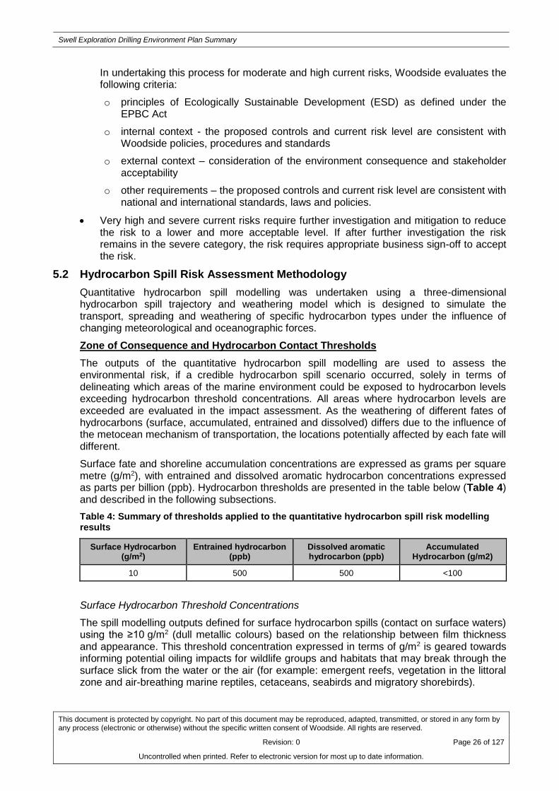
5.2 Hydrocarbon Spill Risk Assessment Methodology
Quantitative hydrocarbon spill modelling was undertaken using a three-dimensional hydrocarbon spill trajectory and weathering model which is designed to simulate the transport, spreading and weathering of specific hydrocarbon types under the influence of changing meteorological and oceanographic forces.
Zone of Consequence and Hydrocarbon Contact Thresholds
The outputs of the quantitative hydrocarbon spill modelling are used to assess the environmental risk, if a credible hydrocarbon spill scenario occurred, solely in terms of delineating which areas of the marine environment could be exposed to hydrocarbon levels exceeding hydrocarbon threshold concentrations. All areas where hydrocarbon levels are exceeded are evaluated in the impact assessment. As the weathering of different fates of hydrocarbons (surface, accumulated, entrained and dissolved) differs due to the influence of the metocean mechanism of transportation, the locations potentially affected by each fate will different.
Surface fate and shoreline accumulation concentrations are expressed as grams per square metre (g/m2), with entrained and dissolved aromatic hydrocarbon concentrations expressed as parts per billion (ppb). Hydrocarbon thresholds are presented in the table below (Table 4) and described in the following subsections.
Table 4: Summary of thresholds applied to the quantitative hydrocarbon spill risk modelling results
Surface Hydrocarbon (g/m2)
Entrained hydrocarbon (ppb)
Dissolved aromatic hydrocarbon (ppb)
Accumulated Hydrocarbon (g/m2)
10 500 500 <100
Surface Hydrocarbon Threshold Concentrations
The spill modelling outputs defined for surface hydrocarbon spills (contact on surface waters) using the ≥10 g/m2 (dull metallic colours) based on the relationship between film thickness and appearance. This threshold concentration expressed in terms of g/m2 is geared towards informing potential oiling impacts for wildlife groups and habitats that may break through the surface slick from the water or the air (for example: emergent reefs, vegetation in the littoral zone and air-breathing marine reptiles, cetaceans, seabirds and migratory shorebirds).

Swell Exploration Drilling Environment Plan Summary
This document is protected by copyright. No part of this document may be reproduced, adapted, transmitted, or stored in any form by any process (electronic or otherwise) without the specific written consent of Woodside. All rights are reserved.
Revision: 0 Page 27 of 127
Uncontrolled when printed. Refer to electronic version for most up to date information.
Thresholds for registering biological impacts resulting from contact of surface slicks have been estimated by different researchers at approximately 10–25 g/m2.
Dissolved Aromatic Hydrocarbon Threshold Concentrations
The threshold concentration value for dissolved aromatic hydrocarbons has been set with reference to results from ecotoxicity tests. Given the Petroleum Activity is an exploration well, no samples of the pontifical hydrocarbons that may be encountered are available; therefore ecotox data from a surrogate hydrocarbon that is evaluated as a suitable analogue is considered. The purpose of the threshold is to inform the assessment of the potential for toxicity impacts to sensitive marine biota. The ecotoxicity tests were undertaken on a broad range of taxa of ecological relevance for which accepted standard test protocols are well established. These ecotoxicology tests are focused on the early life stages of test organisms, when organisms are typically at their most sensitive. The ecotoxicology tests were conducted on six mainly tropical-subtropical species representatives from six major taxonomic groups.
Based on these ecotoxicology tests, a dissolved aromatic hydrocarbon threshold of 500 ppb has been adopted. This 500 ppb threshold is significantly less than the lowest no observable effect concentration (NOEC) for the most sensitive organism tested. Therefore, it is considered that the 500 ppb dissolved aromatic threshold is a conservative threshold to apply to condensate that may be encountered during the Petroleum Activities Program.
Entrained Hydrocarbon Threshold Concentrations
The threshold concentration of entrained hydrocarbons that could result in a biological impact cannot be determined directly using available ecotoxicity data for water accommodated fraction (WAF) of hydrocarbons. However, it is likely the data specific to dissolved hydrocarbon represents a worst-case scenario. This is owing to the fact that entrained hydrocarbons are less biologically available to organisms through absorption into their tissues than dissolved hydrocarbons. It is therefore expected that the entrained threshold concentration of 500 ppb will represent a potential impact substantially lower than the NOEC concentrations.
Accumulated Hydrocarbon Threshold Concentrations
Published data define accumulated hydrocarbon <100 g/m2 to have an appearance of a stain on shorelines, with an accumulated hydrocarbons ≥100 g/m2 considered to be the threshold that could impact the survival and reproductive capacity of benthic epifaunal invertebrates living in intertidal habitat.
Swell Exploration Drilling Environment Plan Summary
This document is protected by copyright. No part of this document may be reproduced, adapted, transmitted, or stored in any form by any process (electronic or otherwise) without the specific written consent of Woodside. All rights are reserved.
Revision: 0 Page 28 of 127
Uncontrolled when printed. Refer to electronic version for most up to date information.
6. ENVIRONMENTAL RISKS AND IMPACTS SUMMARY
Table 5 presents a summary of the sources of risk, analysis and evaluation for the Petroleum Activities Program, using the methodology described above in Section 5 of this EP Summary. There are two types of environmental risk sources identified for the Petroleum Activities Program which relate to activities which are planned and either undertaken on a routine or non-routine basis or which may occur from unplanned activities were also identified. These sources of risk range from small scale chemical spills with a low environmental consequence to hydrocarbon spill events with high environmental consequence. These sources of risk include:
A detailed description of environmental risks and potential impacts together with a summary of control measures have been presented in Appendix A.

Swell Exploration Drilling Environment Plan Summary
This document is protected by copyright. No part of this document may be reproduced, adapted, transmitted, or stored in any form by any process (electronic or otherwise) without the specific written consent of Woodside. All rights are reserved.
Revision: 0 Page 29 of 127
Uncontrolled when printed. Refer to electronic version for most up to date information.
Table 5: Environmental Risk and Impacts Register Summary
Source of Risk Areas of Impact / Environmental Impacts
Residual Risk Rating
Co
ns
eq
uen
ce
Potential Consequence level of impact
Lik
eli
ho
od
Res
idu
al R
isk
Planned Activities (Routine and Non-routine)
Proximity of activity vessels and MODU causing interference with or displacement of third party vessels (commercial shipping and commercial/ recreational fishing)
Isolated social impact potentially resulting from interference with other sea users (e.g. commercial and recreational fishing, and shipping) E
Reputation/brand – Isolated and short-term local concern.
1 L
Wellhead left in-situ causing interference with or displacement to third party vessels (commercial shipping and commercial/ recreational fishing)
Isolated social impact potentially resulting from interference with other sea users (e.g. commercial and recreational fishing, and shipping)
E Reputation/brand – Isolated and short-term local concern.
1 L
Disturbance to benthic habitat from MODU anchoring and drilling operations
Damage to benthic habitats from anchoring and drilling operations
E Environment – localised and medium term effect to benthic communities.
1 L
Generation of noise from activity vessels and MODU
Temporary and minor disruption (e.g. avoidance or attraction) to fauna, including protected species.
F Environment – Slight and temporary disruption to a small proportion of protected species.
1 L
Generation of noise from VSP Environmental impact - temporary disruption to fauna, including protected species
F Environment – Slight and temporary disruption to a small proportion of protected species.
2 L
Discharge from MODU and project vessels of:
• sewage
• grey water
• putrescible waste
• bilge water
• deck drainage
Localised and temporary effects to water quality and marine biota in offshore waters.
F
Environment – Slight and/or temporary decrease in water quality.
2 L

Swell Exploration Drilling Environment Plan Summary
This document is protected by copyright. No part of this document may be reproduced, adapted, transmitted, or stored in any form by any process (electronic or otherwise) without the specific written consent of Woodside. All rights are reserved.
Revision: 0 Page 30 of 127
Uncontrolled when printed. Refer to electronic version for most up to date information.
Source of Risk Areas of Impact / Environmental Impacts
Residual Risk Rating
Co
ns
eq
uen
ce
Potential Consequence level of impact
Lik
eli
ho
od
Res
idu
al R
isk
Routine and non-routine discharge of drill cuttings and drilling fluids (WBM and NWBM)
Localised burial and smothering of benthic habitats.
Localised and temporary minor effects to water quality (e.g. turbidity increase) and marine biota in offshore waters.
E
Environment – Minor, short term contamination above background national/international quality standards.
Environment – Slight and/or temporary decrease in water quality.
1 L
Discharge of well annular fluids Localised water quality, marine sediment and ecosystem and habitat impacts. No-effect concentration within meters of the release location.
F Environment – localised and short term effect to benthic communities.
1 L
Routine discharge of cementing and subsea fluids
Localised burial and smothering of benthic habitats.
Localised and temporary minor effects to water quality (e.g. turbidity increase) and marine biota in offshore waters
E
Environment – Minor, short term contamination above background national/international quality standards.
Environment – Slight and/or temporary decrease in water quality.
1 L
Fuel combustion Reduced local air quality from atmospheric emissions
F Environment – Slight and temporary decrease in local air quality
2 L
External Lighting on MODU and Activity Support Vessels
Disturbance to marine fauna, particularly seabirds, marine turtles and fish.
F Environment – temporary impact/disturbance to species.
1 L
Unplanned Activities (Accidents / Incidents)
Loss of well integrity Short to medium term impacts to the offshore marine environment.
Long-term impacts to sensitive nearshore areas of offshore islands (e.g. the Montebello/Barrow/Lowendal Island Group) and coastal shorelines (e.g. Ningaloo Coast).
Disruption to marine fauna, including protected
B
Environment – Large scale and long term environmental effects to sensitive biota and habitats. Recovery >10 years or permanent.
Reputation/brand – Serious national and international concern, economic impact on commercial and recreational marine-based activities.
2 H

Swell Exploration Drilling Environment Plan Summary
This document is protected by copyright. No part of this document may be reproduced, adapted, transmitted, or stored in any form by any process (electronic or otherwise) without the specific written consent of Woodside. All rights are reserved.
Revision: 0 Page 31 of 127
Uncontrolled when printed. Refer to electronic version for most up to date information.
Source of Risk Areas of Impact / Environmental Impacts
Residual Risk Rating
Co
ns
eq
uen
ce
Potential Consequence level of impact
Lik
eli
ho
od
Res
idu
al R
isk
species.
Potential medium-term interference with or displacement of other sea users (e.g. fishing and shipping).
Vessel collision Minor and temporary disruption to marine fauna, including protected species.
Minor and/or temporary impacts to water quality. D
Environment – Slight and/or temporary decrease in water quality.
Environment – Slight and temporary disruption to a small proportion of protected species.
1 M
Bunkering Minor and temporary disruption to marine fauna, including protected species.
Minor and/or temporary impacts to water quality. E
Environment – Slight and/or temporary decrease in water quality.
Environment – Slight and temporary disruption to a small proportion of protected species.
3 M
Drilling fluids Minor and temporary disruption to marine fauna, including protected species.
Minor and/or temporary impacts to water quality.
E
Environment – Slight and/or temporary decrease in water quality. 2 M
Venting of gas (well kick) Localised and temporary reduction in air quality as the gas vents to the atmosphere.
F Environment – Slight and temporary decrease in local air quality.
2 L
Deck and subsea spills Minor and temporary disruption to marine fauna, including protected species.
Minor and/or temporary impacts to water quality. E
Environment – Slight and/or temporary decrease in water quality.
Environment – Slight and temporary disruption to a small proportion of protected species.
2 M
Loss of hazardous and non-hazardous waste
Minor and/or temporary impacts to water quality. F
Environment – Slight and/or temporary decrease in water quality.
2 L
Vessel collision with marine fauna Minor and temporary disruption to marine fauna, E Environment - Fatality of an individual or a 1 L

Swell Exploration Drilling Environment Plan Summary
This document is protected by copyright. No part of this document may be reproduced, adapted, transmitted, or stored in any form by any process (electronic or otherwise) without the specific written consent of Woodside. All rights are reserved.
Revision: 0 Page 32 of 127
Uncontrolled when printed. Refer to electronic version for most up to date information.
Source of Risk Areas of Impact / Environmental Impacts
Residual Risk Rating
Co
ns
eq
uen
ce
Potential Consequence level of impact
Lik
eli
ho
od
Res
idu
al R
isk
including protected species. number of individuals with no threat to overall population viability.
Loss of station keeping. Localised disturbance of benthic habitats. C
Environment – Localised and long term effects to community/habitat structure and marine primary producers.
1 M
Dropped objects resulting in seabed disturbance.
Localised short-term damage of benthic subsea habitats in the immediate location of the dropped object.
F Environment – Slight and/or temporary impact to non-significant benthic communities. 2 L

Swell Exploration Drilling Environment Plan Summary
This document is protected by copyright. No part of this document may be reproduced, adapted, transmitted, or stored in any form by any process (electronic or otherwise) without the specific written consent of Woodside. All rights are reserved.
Revision: 0 Page 33 of 127
Uncontrolled when printed. Refer to electronic version for most up to date information.
7. ONGOING MONITORING OF ENVIRONMENTAL PERFORMANCE
The Petroleum Activities Program will be managed in compliance with the Swell Exploration Drilling EP accepted by NOPSEMA under the Environment Regulations, other relevant environmental legislation and Woodside’s Management System.
The objective of the Swell Exploration Drilling EP is to identify, mitigate and manage potentially adverse environmental impacts associated with the Petroleum Activities Program, during both planned and unplanned operations, to ALARP and an acceptable level.
For each environmental aspect (risk) and associated environmental impacts (identified and assessed in the Environmental Risk Assessment of the EP) specific environmental performance outcomes, controls, environmental performance standards and measurement criteria have been developed. The control measures (available in Appendix A) will be implemented in accordance with the relevant environmental performance standards to achieve the environmental performance outcomes. The specific measurement criteria provide the evidence base to demonstrate that the environmental performance standards and outcomes are achieved.
The implementation strategy detailed in the Swell Exploration Drilling EP identifies the roles/responsibilities and training/competency requirements for all personnel (Woodside and its contractors) in relation to implementing controls, managing non-conformance, emergency response and meeting monitoring, auditing, and reporting requirements during the activity.
Woodside and its contractors will undertake a program of periodic monitoring during the Petroleum Activities Program, starting at mobilisation of each activity and continuing through the duration of each activity until activity completion. This information is collected using appropriate tools and systems, based on the environmental performance outcomes, performance standards and measurement criteria in the Swell Exploration Drilling EP.
The tools and systems collect, as a minimum, the data (evidence) referred to in the measurement criteria. The collection of this data (and assessment against the measurement criteria) forms part of the permanent record of compliance maintained by Woodside and the basis for demonstrating that the environmental performance outcomes and standards are met, which is then summarised in a series of routine reporting documents.
Monitoring of environmental performance is undertaken as part of the following:
Environmental Performance Report will be submitted to NOPSEMA within 12 months of commencement of the activity to assess and confirm compliance with the accepted environmental performance objectives, standards and measurement criteria outlined in the Swell Exploration Drilling EP
Activity-based inspections undertaken by Woodside’s environment function to review compliance against the Swell Exploration Drilling EP, verify effectiveness of the implementation strategy and to review environmental performance
Environmental performance is also monitored daily via daily drilling reports during operations
Senior management regularly monitors and reviews environmental performance via a monthly report which details environmental performance and compliance with Woodside standards.
Woodside employees and contractors are required to report all environmental incidents and non-conformance with environmental performance outcomes and standards in the Swell Exploration Drilling EP. Incidents will be reported using an Incident and Hazard Report Form, which includes details of the event, immediate actions taken to control the situation, and corrective actions to prevent reoccurrence. An internal computerised database is used for the

Swell Exploration Drilling Environment Plan Summary
This document is protected by copyright. No part of this document may be reproduced, adapted, transmitted, or stored in any form by any process (electronic or otherwise) without the specific written consent of Woodside. All rights are reserved.
Revision: 0 Page 34 of 127
Uncontrolled when printed. Refer to electronic version for most up to date information.
recording and reporting of these incidents. Incident corrective actions are monitored to ensure they are closed out in a timely manner.
The Swell Exploration Drilling EP is supported by an assessment of the environmental impacts and risks associated with potential hydrocarbon spill scenarios and hydrocarbon spill preparedness and response measures in relation to the risk assessment and the identified hydrocarbon spill scenarios. A summary of Woodside’s response arrangements in the Oil Pollution Emergency Plan (OPEP) is provided in Section 8.
7.1 Environment Plan Revisions and Management of Change
Revision of the Swell Exploration Drilling EP will be undertaken in accordance with the requirements outlined in Regulations 17, Regulation 18 and Regulation 19 of the Environment Regulations. Woodside will submit a revision to the EP due to all or any of the following:
When any significant modification or new stage of the activity that is not provided for in the Swell Exploration Drilling EP.
Before, or as soon as practicable after, the occurrence of any significant new or significant increase in environmental risk or impact not provided for in the Swell Exploration Drilling EP
At least 14 days before the end of each period of five years commencing on the day on which the original and subsequent revisions of the EP is accepted under Regulation 11 of the Environment Regulations
As requested by NOPSEMA.
Management of changes relevant to the Swell Exploration Drilling EP, concerning the scope of the activity description including review of advances in technology at stages where new equipment may be selected such as vessel contracting, changes in understanding of the environment, including all current advice on species protected under EPBC Act and current requirements for Commonwealth Marine Reserves and potential new advice from external stakeholders will be managed in accordance with internal procedures for management of change. These provide guidance on the Environment Regulations that may trigger a revision and resubmission of the EP to NOPSEMA. They also provide guidance on what constitutes a significant new risk or increase in risk. A risk assessment will be conducted in accordance with Woodside’s Environmental Risk Management Methodology to determine the significance of any potential new environmental impacts or risks not provided for in the Swell Exploration Drilling EP. Risk assessment outcomes are reviewed in compliance with Regulation 17 of the Environment Regulations.
Minor changes where a review of the activity and the environmental risks and impacts of the activity do not trigger a requirement for a revision, under Regulation 17 of the Environment Regulations, will be considered a ‘minor revision’. Minor administrative changes to the Swell Exploration Drilling EP, where an assessment of the environmental risks and impacts is not required (e.g. document references, phone numbers, etc.), will also be considered a ‘minor revision’. Minor revisions and administrative changes as defined above will be made to the Swell Exploration Drilling EP using Woodside’s document control process. Minor revisions will be tracked and incorporated during scheduled internal reviews.

Swell Exploration Drilling Environment Plan Summary
This document is protected by copyright. No part of this document may be reproduced, adapted, transmitted, or stored in any form by any process (electronic or otherwise) without the specific written consent of Woodside. All rights are reserved.
Revision: 0 Page 35 of 127
Uncontrolled when printed. Refer to electronic version for most up to date information.
8. OIL POLLUTION EMERGENCY RESPONSE ARRANGEMENTS
Woodside’s OPEP for the Petroleum Activities Program has the following components:
Oil Pollution Emergency Arrangements (Australia)
Swell Exploration Drilling Oil Pollution First Strike Plan
Oil Spill Preparedness and Response Mitigation Assessment for Swell Exploration Drilling Campaign.
8.1 Woodside Oil Pollution Emergency Arrangements (Australia)
This document outlines the emergency and crisis management incident command structure (ICS) and Woodside’s response arrangements to competently respond to and escalate a hydrocarbon spill event. The document interfaces externally with Commonwealth, State and industry response plans and internally with Woodside’s ICS.
Woodside’s Oil Pollution Emergency Arrangements (Australia) details the following support arrangements:
Access to MODU to drill intervention well via Memorandum of Understanding (MoU) with other industry participants
Master services agreement with Australian Marine Oil Spill Centre (AMOSC) for the supply of experienced personnel and equipment
Access to Wild Well Control’s capping stack, subsea first response toolkit (SFRT) equipment and experienced personnel for the rapid deployment and installation of a capping stack, where feasible (may require well intervention prior to deployment)
Other support services such as 24/7 hydrocarbon spill trajectory modelling and satellite monitoring services as well as ‘on-call’ aerial, marine, logistics and waste management support
Mutual Aid Agreements with other oil and gas operators in the region for the provision of assistance in a hydrocarbon spill response.
8.2 Swell Exploration Drilling Oil Pollution First Strike Plan
The Swell Exploration Drilling Oil Pollution First Strike Plan is an activity specific document which provides details on the tasks required to mobilise a first strike response for the first 24 hours of a hydrocarbon spill event. These tasks include key response actions and regulatory notifications. The intent of the document is to provide immediate oil spill response guidance to the Incident Management Team until a full Incident Action Plan specific to the oil spill event is developed.
The activity vessels will have Ship Oil Pollution Emergency Plans (SOPEPs) in accordance with the requirements of International Convention for the Prevention of Pollution from Ships (MARPOL) 73/78 Annex I. These plans outline responsibilities, specify procedures and identify resources available in the event of a hydrocarbon or chemical spill from vessel activities. The Swell Exploration Drilling Oil Pollution First Strike Plan is intended to work in conjunction with the SOPEPs.
Woodside’s oil spill arrangements are tested by conducting periodic exercises. These exercises are conducted to test the response arrangements outlined in the Swell Exploration Drilling Oil Pollution First Strike Plan and to ensure that personnel are familiar with spill response procedures, in particular, individual roles and responsibilities and reporting requirements.

Swell Exploration Drilling Environment Plan Summary
This document is protected by copyright. No part of this document may be reproduced, adapted, transmitted, or stored in any form by any process (electronic or otherwise) without the specific written consent of Woodside. All rights are reserved.
Revision: 0 Page 36 of 127
Uncontrolled when printed. Refer to electronic version for most up to date information.
8.3 Oil Spill Preparedness and Response Mitigation Assessment
Woodside has developed an oil spill preparedness and response position in order to demonstrate that risks and impacts associated with loss of hydrocarbons from the Petroleum Activities Program would be mitigated and managed to ALARP and would be of an acceptable level.
The following oil spill response strategies were evaluated and subsequently pre-selected for a significant oil spill event (level 2 or 3 under the National Plan) from the Petroleum Activities Program:
Source Control (Well Control and Intervention) - Woodside’s strategy is to minimise the volume of hydrocarbons released from an oil spill event. Woodside plans to deploy the following controls specific to well loss of containment scenarios, if required for the Petroleum Activities Program:
o Well intervention (relief well drilling) – primary source control response to control or kill the well
o Source control (deployment of capping stack) – secondary source control response that may be implemented following successful well intervention
o SFRT deployment to clear debris, assess the well at the sea bed, and if practicable, attempt to close the emergency blowout preventer – secondary source control response to support deployment of capping stack
Monitor and Evaluate - gathering of data and evaluation of data to inform the oil spill response planning and operations. It includes fate and trajectory modelling, spill tracking, weather updates and field observations. Woodside would implement operational monitoring plans to satisfy the requirements of this mitigation control. Further information on monitoring is provided in Section 8.4.
Open Water Containment and Recovery – involves the physical containment and mechanical removal of hydrocarbons from the marine environment. Suitable vessels would be drawn from Woodside’s integrated fleet, other operators in the region and from the charter market. Open water containment and recovery equipment (e.g. booms and skimmers) would be sourced from Woodside’s own equipment, AMSA, AMOSC and Oil Spill Response Limited (OSRL) stockpiles.
Oiled Wildlife Response – actions undertaken to mitigate the effects of hydrocarbon on wildlife. Staging sites will be established for shoreline or vessel based oiled wildlife response teams. Once recovered to a staging site, wildlife will be transported to the designated oiled wildlife facility for stabilisation and treatment.
Shoreline Cleanup – undertaken to remove residual hydrocarbons from shorelines. Shoreline cleanup consists of different manual and mechanical recovery techniques to remove hydrocarbon and contaminated debris from a shoreline.
To support the above response strategies, Woodside has access to Veolia’s waste management facilities as well as waste storage equipment from AMOSC, AMSA and OSRL.
Implementation of these response strategies would be re-assessed during a spill event, with consideration of the size of spill, weather conditions and other constraints.
A summary of potential risks; potential impacts and control measures for oil spill response during the Petroleum Activities Program is included in Appendix B.
8.4 Monitoring
Operational Monitoring

Swell Exploration Drilling Environment Plan Summary
This document is protected by copyright. No part of this document may be reproduced, adapted, transmitted, or stored in any form by any process (electronic or otherwise) without the specific written consent of Woodside. All rights are reserved.
Revision: 0 Page 37 of 127
Uncontrolled when printed. Refer to electronic version for most up to date information.
To gain an understanding of the spill event, its movement and to direct mitigation activities to the optimal locations, the following operational monitoring programs are available for implementation:
Predictive modelling of hydrocarbons to assess resources at risk
Surveillance and reconnaissance to detect hydrocarbons and resources at risk
Monitoring of hydrocarbon presence, properties, behaviour and weathering in water
Pre-emptive assessment of sensitive receptors at risk
Monitoring of contaminated resources and the effectiveness of response and clean-up operations.
Scientific Monitoring
Woodside would activate its Scientific Monitoring Program (SMP) following a Level 2 or 3 hydrocarbon release, or any release event with the potential, or actual, contact to sensitive environmental receptors. The nature and scale of the spill event would dictate the implementation and operational timing of the SMP. Ten targeted SMPs may be implemented to address a range of physical-chemical (water and sediment) and biological receptors (species and habitats) including EPBC Act listed species, environmental values associated with Protected Areas and socio-economic values such as fisheries. When activated the Woodside SMP has the following objectives:
Assess the extent, severity and persistence of the environmental impacts from the spill event
Monitor the subsequent recovery of impacted key species, habitats and ecosystems
Acquisition of pre-emptive baseline data where practicable and relevant given existing baseline.

Swell Exploration Drilling Environment Plan Summary
This document is protected by copyright. No part of this document may be reproduced, adapted, transmitted, or stored in any form by any process (electronic or otherwise) without the specific written consent of Woodside. All rights are reserved.
Revision: 0 Page 38 of 127
Uncontrolled when printed. Refer to electronic version for most up to date information.
9. CONSULTATION
In support of the Swell Exploration Drilling EP, Woodside conducted a stakeholder assessment and engaged with relevant stakeholders to inform decision-making and planning for continued production activities in accordance with the requirements of Regulation 11A and 14(9) of the Environment Regulations.
Woodside conducted a stakeholder assessment based on the activity location, timing and potential impacts. A consultation fact sheet was sent to all stakeholders identified through the stakeholder assessment process prior to lodgement of the Swell Exploration Drilling EP with NOPSEMA for assessment and acceptance. Woodside provided information about the Petroleum Activities Program to the relevant stakeholders listed in Table 6. Woodside considers relevant stakeholders for routine operations as those that undertake normal business or lifestyle activities in the vicinity of the existing facility (or their nominated representative) or have a State or Commonwealth regulatory role.
Table 6: Relevant stakeholder identified for the Petroleum Activities Program
Stakeholder Relevance
Department of Industry, Innovation and Science Department of relevant Commonwealth Minister
Department of Mines and Petroleum Department of relevant State Minister
Australian Hydrographic Service (AHS) Marine safety
Pearl Producers Association Commercial Industry management
Department of Fisheries (Western Australia) Fisheries management – State
Australian Fisheries Management Authority Fisheries management - Commonwealth
Commonwealth fisheries
Commonwealth fisheries
Western Skipjack Fishery
Western Tuna and Billfish Fishery
North West Slope Trawl Fishery
Southern Bluefin Tuna
Western Deepwater Trawl Fishery
Western Australian fisheries
Western Australian Fisheries
Mackerel Fishery
Pilbara Trawl Fishery
Pilbara Trap Fishery
AMSA Oil spill preparedness (Australian waters)
Maritime safety
Department of Transport Oil spill preparedness (Western Australian waters)
Western Australian Fishing Industry Council (WAFIC)
Commercial fishery – state
Exmouth Community Reference Group Government, industry and community groups
Woodside also made available advice about the Petroleum Activities Program to other stakeholders who may be interested in the activity or who have previously expressed an interest in being kept informed about Woodside’s activities in the region. The following are stakeholders that have been identified as ‘interested’ in the Petroleum Activities Program:
AMSA (marine pollution)

Swell Exploration Drilling Environment Plan Summary
This document is protected by copyright. No part of this document may be reproduced, adapted, transmitted, or stored in any form by any process (electronic or otherwise) without the specific written consent of Woodside. All rights are reserved.
Revision: 0 Page 39 of 127
Uncontrolled when printed. Refer to electronic version for most up to date information.
Department of Parks and Wildlife
Australian Customs Service – Border Protection Command
Commonwealth Fisheries Association
Recfishwest
World Wildlife Fund for Nature (WWF)
Australian Conservation Foundation
Wilderness Society
International Fund for Animal Welfare
Australian Petroleum Production and Exploration Association (APPEA)
AMOSC.
Woodside received feedback on the Petroleum Activities Program from a range of stakeholders, including government agencies and commercial fishing organisations. Issues of interest or concern included the location of the activities across commercial fishing areas. Woodside considered this feedback in its development of control measures specific to the Petroleum Activities Program. A summary of feedback and Woodside‘s response is presented in Appendix C.
9.1 Ongoing Consultation
Consultation activities for the Petroleum Activities Program build upon Woodside’s extensive and ongoing stakeholder consultation for offshore petroleum activities in this area.
Feedback received through community engagement and consultation will be captured in Woodside’s stakeholder database and actioned where appropriate through the Petroleum Activities Program Project Manager. Implementation of ongoing engagement and consultation activities for the Petroleum Activities Program will be undertaken by Woodside Corporate Affairs consistent with Woodside’s External Stakeholder Engagement Operating Standard.
Woodside will continue to accept feedback from all stakeholders throughout the duration of the accepted Swell Exploration Drilling EP. Stakeholder feedback should be made to the nominated liaison person, identified in Section 10 of this EP Summary.

Swell Exploration Drilling Environment Plan Summary
This document is protected by copyright. No part of this document may be reproduced, adapted, transmitted, or stored in any form by any process (electronic or otherwise) without the specific written consent of Woodside. All rights are reserved.
Revision: 0 Page 40 of 127
Uncontrolled when printed. Refer to electronic version for most up to date information.
10. TITLEHOLDER NOMINATED LIAISON PERSON
For further information on this Petroleum Activities Program, please contact:
Kate McCallum
Corporate Affairs Adviser
240 St Georges Terrace
Perth WA 6000
Toll free: 1800 442 977

Swell Exploration Drilling Environment Plan Summary
This document is protected by copyright. No part of this document may be reproduced, adapted, transmitted, or stored in any form by any process (electronic or otherwise) without the specific written consent of Woodside. All rights are reserved.
Revision: 0 Page 41 of 127
Uncontrolled when printed. Refer to electronic version for most up to date information.
11. ABBEVIATIONS AND ACRONYMS
Term Description / Definition
Abbreviations
AMOSC Australian Marine Oil Spill Centre
AMSA Australian Maritime Safety Authority
BIA Biologically Important Area
EP Environment Plan
EPBC Act Environment Protection and Biodiversity Conservation Act, 1999
Environment Regulations
Offshore Petroleum and Greenhouse Gas Storage (Environment) Regulations 2009 (Cth)
ENVID Environmental Hazard Identification
ESD Ecologically Sustainable Development
ICS Incident Command Structure
IUCN International Union for the Conservation of Nature
KEF Key Ecological Feature
MARPOL International Convention for the Prevention of Pollution from Ships, 1973
MODU Mobile offshore drilling unit
MNES Matters of National Environmental Significance
NOPSEMA National Offshore Petroleum Safety and Environmental Management Authority
NWS North West Shelf
OPEP Oil Pollution Emergency Plan
OSRL Oil Spill Response Limited
Petroleum Activities Program
Comprises of activities being undertaken in licence areas WA-49-L and WA-26-PL (as well as within non-Woodside production licence areas), including preparation activities; operations; and inspection, maintenance and repair activities
ROV Remote Operated Vehicle
SFRT Subsea First Response Toolkit
SMP Scientific Monitoring Program
SOPEP Ship Oil Pollution Emergency Plan
Woodside Woodside Energy Ltd.
ZoC Zone of Consequence

Swell Exploration Drilling Environment Plan Summary
This document is protected by copyright. No part of this document may be reproduced, adapted, transmitted, or stored in any form by any process (electronic or otherwise) without the specific written consent of Woodside. All rights are reserved.
Revision: 0 Page 42 of 127
Uncontrolled when printed. Refer to electronic version for most up to date information.
APPENDIX A: DETAILED ENVIRONMENTAL IMPACTS AND RISKS

Swell Exploration Drilling Environment Plan Summary
This document is protected by copyright. No part of this document may be reproduced, adapted, transmitted, or stored in any form by any process (electronic or otherwise) without the specific written consent of Woodside. All rights are reserved.
Revision: 0 Page 43 of 127
Uncontrolled when printed. Refer to electronic version for most up to date information.
PLANNED ACTIVITIES (ROUTINE AND NON-ROUTINE)
Physical Presence: Interferences with or Displacement of Third Party Vessels
Source of Risk
Environmental Value Potentially Impacted Evaluation
Soil
and
Gro
undw
ate
r
Ma
rin
e S
edim
ent
Wate
r Q
ualit
y
Air Q
ualit
y (
incl.
odour)
Ecosyste
ms /
Habitats
Specie
s
Socio
-econom
ic
Co
nse
qu
ence
Lik
elih
oo
d
Re
sid
ua
l R
isk
Proximity of MODU and activity support vessels causing interference with or displacement to third party vessels (commercial shipping and commercial/ recreational fishing)
X E 1 L
Wellhead left in-situ causing interference with or displacement to third party vessels (commercial shipping, and commercial/ recreational fishing).
X E 1 L
Description of Source of Risk
In order to drill the well the MODU will be present for approximately 90 to 120 days (includes mobilisation, demobilisation and contingency), depending on operational requirements.
Activity support vessels will support the MODU. One vessel will be present at the MODU on standby at all times and the other/s will transit in and out of the Operational Area to port (e.g. Exmouth) for emergency and routine operations.
The activity support vessels will make approximately two-four trips per week. The presence of the MODU and associated activity support vessel movements could present a navigational hazard to shipping and commercial fishing activities in the Operational Area.
On completion of a well, the wellhead assembly may be left in-situ if routine removal techniques are unsuccessful. The wellhead left in-situ could potentially interfere with third party activities (in particular fishing activities).
Potential Environmental Impacts
Value Description of Potential Environmental Impact
Socio-economic Environment
Displacement to commercial fishing activities
A number of Commonwealth and State managed fisheries occur in the region. The proposed exploration well (approximately 154 m water depth) is situated within three Commonwealth and seven State managed fisheries. However, only one fishery, the Pilbara Demersal Scalefish fishery, is considered to be active in the vicinity of the Operational Area. There was no direct response from licence holders during the consultation period with participants in this fishery.
This overlap of the Operational Area with commercial fishing activity may temporarily exclude fishers from the area resulting in a perceived loss of catch and potential for loss of gear (particularly, in relation to deployed traps). However, the greatest trap fishing effort occurs in waters less than 50 m depth, considerably shallower than the Operational Area.
Potential impacts to commercial fishing activities within the Operational Area are considered temporary and short term, consisting of minor interference (navigational hazard) and localised displacement/avoidance by commercial trawling and line fishery vessels within the immediate vicinity of the MODU. However, there was no direct response from title holders during the stakeholder consultation period, and as such the potential impact is considered to be minor and temporary.
Potential impacts to commercial fishing in the unlikely event the wellhead remains in-situ are snag hazards of fishing equipment such as trawl fisheries that operate equipment along the seabed. The one fishery considered active in the vicinity of the Operational Area, the Pilbara Demersal Scalefish fishery, uses trawling practices (the Pilbara Trawl Fishery). However, trawling is closed in Zone 1

Swell Exploration Drilling Environment Plan Summary
This document is protected by copyright. No part of this document may be reproduced, adapted, transmitted, or stored in any form by any process (electronic or otherwise) without the specific written consent of Woodside. All rights are reserved.
Revision: 0 Page 44 of 127
Uncontrolled when printed. Refer to electronic version for most up to date information.
of the Pilbara Trawl Fishery, which overlaps with the Operational Area. Zone 2 of the Pilbara Trawl fishery is located to the north of the Operational Area and is therefore highly unlikely to be impacted if the wellhead remains in-situ. Given the activity of fisheries in the vicinity of the Operational Area (i.e. non- trawling), impacts to the commercial fishing activities if the wellhead remains in-situ are considered highly unlikely.
Displacement of recreational fishing
Stakeholder consultation did not identify any key recreational fishing activity within the Operational Area. Recreational fishing in the region is concentrated around the coastal waters and islands of the NWS such as the Muiron Islands (approximately 28 km from the Operational Area). Due to the distance offshore and water depths, recreational fishing is unlikely to occur in the Operational Area. In the event that recreational fishing effort occurred within the Operational Area, displacement as a result of the Petroleum Activities Program would be minimal and relate only to the 500 m exclusion/safety zone around the MODU. Therefore, the potential impact is considered to be minor.
Given the distance of the Swell well offshore, snagging hazards to recreational fishing as a result of the wellhead remaining in-situ are highly likely.
Displacement to commercial shipping
The presence of the MODU and activity support vessels could potentially cause temporary disruption to commercial shipping. The indicative well location lies beyond designated shipping fairways in the region and the Operational Area is not subject to significant commercial vessel traffic. No recognised shipping fairways overlap or occur in the vicinity of the Operational Area, although consultation with AMSA has indicated that the Operational Area is subject to support vessels transiting between existing offshore infrastructure off North West Cape and the Mary Anne Passage. Most vessel activity in the vicinity of the Operational Area is associated with nodes such as offshore facilities (e.g. floating production and storage offloading (FPSO) vessels) and ports; no such nodes occur within the Operational Area. The potential impacts associated with this Petroleum Activities Program include short-term displacement of vessels as they make slight course alteration to avoid the drilling location. Therefore, the potential impact is considered to be minor and temporary.
Given the water depth of the Swell well, impacts to commercial shipping as a result of the wellhead remaining in-situ are highly likely.
Summary Given the adopted controls, it is considered that physical presence of the MODU and activity support vessels will not result in a potential impact greater than minor temporary impact to shipping and commercial/recreational fishing interests.
Summary of Control Measures
Marine Orders 30 (Prevention of Collisions) 2009
Marine Order 21 (Safety of navigation and emergency procedures) 2012
Establishment of a 500 m safety exclusion zone around MODU and communicated to marine users
A activity support vessel is on standby during drilling activities to communicate with third-party vessels and assist in maintaining the safety exclusion zone
The activity support vessel will undertake surveillance/watch actions to prevent unplanned interactions
Notify Australian Hydrographic Service (AHS) of activities and movements prior to the MODU being on location
Notify relevant State and Commonwealth fisheries of activities
Notify AMSA Joint Rescue Coordination Centre (JRCC) of activities and movements
Routine removal of wellhead
Where routine removal of wellhead is unsuccessful, Woodside will notify marine users (including AHS and fisheries) the wellhead will remain in-situ
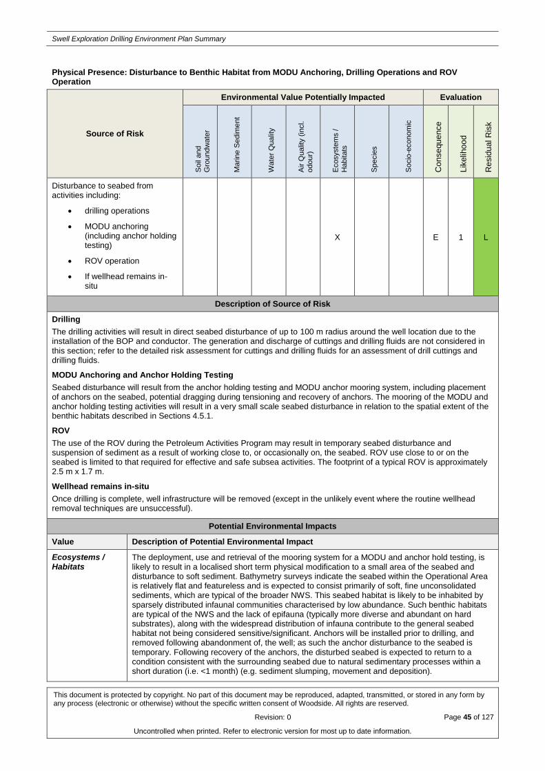
Swell Exploration Drilling Environment Plan Summary
This document is protected by copyright. No part of this document may be reproduced, adapted, transmitted, or stored in any form by any process (electronic or otherwise) without the specific written consent of Woodside. All rights are reserved.
Revision: 0 Page 45 of 127
Uncontrolled when printed. Refer to electronic version for most up to date information.
Physical Presence: Disturbance to Benthic Habitat from MODU Anchoring, Drilling Operations and ROV Operation
Source of Risk
Environmental Value Potentially Impacted Evaluation
Soil
and
Gro
undw
ate
r
Ma
rin
e S
edim
ent
Wate
r Q
ualit
y
Air Q
ualit
y (
incl.
odour)
Ecosyste
ms /
Habitats
Specie
s
Socio
-econom
ic
Co
nse
qu
ence
Lik
elih
oo
d
Re
sid
ua
l R
isk
Disturbance to seabed from activities including:
drilling operations
MODU anchoring (including anchor holding testing)
ROV operation
If wellhead remains in-situ
X E 1 L
Description of Source of Risk
Drilling
The drilling activities will result in direct seabed disturbance of up to 100 m radius around the well location due to the installation of the BOP and conductor. The generation and discharge of cuttings and drilling fluids are not considered in this section; refer to the detailed risk assessment for cuttings and drilling fluids for an assessment of drill cuttings and drilling fluids.
MODU Anchoring and Anchor Holding Testing
Seabed disturbance will result from the anchor holding testing and MODU anchor mooring system, including placement of anchors on the seabed, potential dragging during tensioning and recovery of anchors. The mooring of the MODU and anchor holding testing activities will result in a very small scale seabed disturbance in relation to the spatial extent of the benthic habitats described in Sections 4.5.1.
ROV
The use of the ROV during the Petroleum Activities Program may result in temporary seabed disturbance and suspension of sediment as a result of working close to, or occasionally on, the seabed. ROV use close to or on the seabed is limited to that required for effective and safe subsea activities. The footprint of a typical ROV is approximately 2.5 m x 1.7 m.
Wellhead remains in-situ
Once drilling is complete, well infrastructure will be removed (except in the unlikely event where the routine wellhead removal techniques are unsuccessful).
Potential Environmental Impacts
Value Description of Potential Environmental Impact
Ecosystems / Habitats
The deployment, use and retrieval of the mooring system for a MODU and anchor hold testing, is likely to result in a localised short term physical modification to a small area of the seabed and disturbance to soft sediment. Bathymetry surveys indicate the seabed within the Operational Area is relatively flat and featureless and is expected to consist primarily of soft, fine unconsolidated sediments, which are typical of the broader NWS. This seabed habitat is likely to be inhabited by sparsely distributed infaunal communities characterised by low abundance. Such benthic habitats are typical of the NWS and the lack of epifauna (typically more diverse and abundant on hard substrates), along with the widespread distribution of infauna contribute to the general seabed habitat not being considered sensitive/significant. Anchors will be installed prior to drilling, and removed following abandonment of, the well; as such the anchor disturbance to the seabed is temporary. Following recovery of the anchors, the disturbed seabed is expected to return to a condition consistent with the surrounding seabed due to natural sedimentary processes within a short duration (i.e. <1 month) (e.g. sediment slumping, movement and deposition).

Swell Exploration Drilling Environment Plan Summary
This document is protected by copyright. No part of this document may be reproduced, adapted, transmitted, or stored in any form by any process (electronic or otherwise) without the specific written consent of Woodside. All rights are reserved.
Revision: 0 Page 46 of 127
Uncontrolled when printed. Refer to electronic version for most up to date information.
Sediment disturbance (resuspension and resulting sedimentation) from ROV activities near the seabed is likely to result in slight and temporary impacts to benthic communities; such effects would be highly localised.
Several KEFs associated with seabed features occur in the region (approximate distances from Operational Area in brackets):
Canyons linking the Cuvier Abyssal Plain and the Cape Range Peninsula (3 km)
Continental Slope Demersal Fish Communities (7 km)
Ancient coastline at 125 m depth contour (8 km)
Note that the Operational Area does not overlap any of these KEFs. Bathymetry of the proposed Swell well location and surrounding seabed did not indicate any features consistent with the Ancient coastline or canyons KEFs (e.g. high relief areas, hard substrates). Given all direct disturbance to benthic habitats (excluding drill cuttings – refer to cuttings risk assessment) will be restricted to within the Operational Area, no disturbance to benthic habitats within these KEFs will occur.
In the unlikely event the wellhead cannot be removed, over time, the cement surrounding the wellhead will likely become buried in sediment as a result of prevailing ocean currents. Over time, the steel wellhead structure will corrode and marine fouling is expected to accumulate, whereby a marine life structure will remain above the seafloor. The wellhead remaining in-situ is expected to have a localised impact not significant to environment receptors, with no lasting effect. No further impacts to benthic habitats are likely.
Summary Given the adopted controls, seabed disturbance will result in minor temporary impact to benthic habitat. The retrieval of the mooring system for a moored MODU, BOP and conductor installation and the use of the ROV will have no greater impact than localised medium-term effects on community/habitat structure.
Summary of Control Measures
Woodside Well Location and Site Appraisal Data Sheet (WLSADS) includes environmental sensitivity and seabed topography to inform the selection of the MODU mooring locations.

Swell Exploration Drilling Environment Plan Summary
This document is protected by copyright. No part of this document may be reproduced, adapted, transmitted, or stored in any form by any process (electronic or otherwise) without the specific written consent of Woodside. All rights are reserved.
Revision: 0 Page 47 of 127
Uncontrolled when printed. Refer to electronic version for most up to date information.
Routine Acoustic Emissions: Generation of Noise from Activity Vessels and MODU
Source of Risk
Environmental Value Potentially Impacted Evaluation
Soil
and
Gro
undw
ate
r
Ma
rin
e S
edim
ent
Wate
r Q
ualit
y
Air Q
ualit
y (
incl.
odour)
Ecosyste
ms /
Habitats
Specie
s
Socio
-econom
ic
Co
nse
qu
ence
Lik
elih
oo
d
Re
sid
ua
l R
isk
Generation of noise from MODU and vessels during normal operations.
X F 1 L
Description of Source of Risk
The MODU and activity support vessels will generate noise both in the air and underwater, due to the operation of thrusters, engines, propeller movement, drilling operations, etc. These noises will contribute to and can exceed ambient noise levels which range from around 90 dB re 1 μPa (root square mean sound pressure level (RMS SPL)) under very calm, low wind conditions, to 120 dB re 1μPa (RMS SPL) under windy conditions (McCauley 2005).
MODU noise
Noise associated with a moored MODU will be restricted to drilling activities, such as drill pipe operations and on board machinery. A range of broadband values (59 to 185 dB re 1 μPa at 1 m (RMS SPL)) have been quoted for various MODUs (Oceans of noise 2004), where noise is likely to be between 100 to 190 dB re 1 μPa at 1 m (RMS SPL) during drilling and between 85 to 135dBre 1 μPa at 1 m (RMS SPL) when not actively drilling. McCauley (1998) recorded received noise levels approximately 117 dB re 1 μPa at 1 m (RMS SPL) at 125 m from a moored MODU whilst actively drilling (with activity support vessel on anchor). The MODU is expected to be on location for up to 90 to 120 days.
Activity support vessel noise
Activity support vessels will maintain DP for short durations, while the vessel is maintaining position prior for loading and unloading. McCauley (1998) measured underwater broadband noise equivalent to approximately 182 dB re 1 μPa at 1 m (RMS SPL) from an activity support vessel holding station in the Timor Sea; it is expected that similar noise levels will be generated by activity support vessels used for this Petroleum Activities Program.
Note that all activity support vessels are required to comply with EPBC Regulation 2000 – Part 8 Interacting with Cetaceans to reduce the likelihood of collisions with cetaceans (refer to Section 5.7.9). Implementing this control may incidentally reduce the noise generated by vessels in proximity to cetaceans as vessels will be travelling slower; slower vessel speeds may reduce underwater noise from machinery noise (main engines) and propeller cavitation.
Potential Environmental Impacts
Value Description of Potential Environmental Impact
Species The Operational Area of the Petroleum Activities Program is located in waters approximately 154 m deep. The fauna associated with this area will be predominantly pelagic species of fish, with migratory species such as turtles, whale sharks and cetaceans present in the area seasonally.
Elevated underwater noise can affect marine fauna, including cetaceans, fish, sharks and rays in three main ways (Oceans of noise 2004, Richardson et al. 1995):
(1) by causing direct physical effects on hearing or other organs (injury)
(2) by masking or interfering with other biologically important sounds (including vocal communication, echolocation, signals and sounds produced by predators or prey)
(3) through disturbance leading to behavioural changes or displacement from important areas.
The thresholds of recommended root square mean sound pressure level (RMS SPL) that could result in behavioural response for cetaceans is expected to be 120 dB RMS SPL for continuous noise sources, and 160 dB RMS SPL for impulsive noise sources. These thresholds are adopted by the United States National Oceanic and Atmospheric Administration (NOAA) and are consistent with the levels presented by Southall et al. (2007). More permanent injury would be expected to occur at 230 dB re 1 µPa (peak) (Southall et al. 2007). Noise generated by the moored MODU and activity support vessels likely to be used for this Petroleum Activities Program does not exceed that

Swell Exploration Drilling Environment Plan Summary
This document is protected by copyright. No part of this document may be reproduced, adapted, transmitted, or stored in any form by any process (electronic or otherwise) without the specific written consent of Woodside. All rights are reserved.
Revision: 0 Page 48 of 127
Uncontrolled when printed. Refer to electronic version for most up to date information.
level so permanent injury to protected species is not anticipated.
Listed threatened and listed migratory species that could be potentially impacted by noise and vibration may be present within the Operational Area and primarily include cetaceans. The Operational Area overlaps BIAs for the following species:
humpback whales (migration BIA): seasonally present June to September
whale shark (foraging): seasonally present between March and June
flatback turtle (internesting): seasonally present between December and March
It is likely that there may be increased numbers of individuals of these species within the Operational Area during the seasonal periods described above. However, even with an increased likelihood of interaction the potential impacts are considered to be minor given the noise levels associated with routine operations of vessels and the MODU. It is reasonable to expect that fauna may demonstrate avoidance or attraction behaviour to the noise generated by the Petroleum Activities Program. For example, when transiting through the area, cetaceans and whale sharks may deviate from their migration corridor, but continue on their migration pathway. Note that the Operational Area is surrounded by open water, with no restrictions (e.g. shallow waters, embayments) to an animal’s ability to avoid the Operational Area. Therefore, any avoidance or attraction behaviours displayed are expected to be localised and temporary. Predicted noise levels from the MODU and project vessels are not considered to be ecologically significant at a population level.
The fauna associated with the Operational Area will be predominantly pelagic species of fish with migratory species such as marine turtles, whale sharks and cetaceans transiting through the Operational Area. Therefore, potential impacts from vessel noise are likely to be restricted to temporary avoidance behaviour to individuals transiting through the Operational Area, and are therefore, considered low.
Summary It is considered that noise generated by project vessels and MODU drilling activities will not result in a potential impact greater than minor and temporary disruption to a small proportion of the populations of marine fauna associated with the Operational Area.
Summary of Control Measures
No controls adopted – no effective controls were identified. Risk is considered to be acceptable and ALARP in its inherent state

Swell Exploration Drilling Environment Plan Summary
This document is protected by copyright. No part of this document may be reproduced, adapted, transmitted, or stored in any form by any process (electronic or otherwise) without the specific written consent of Woodside. All rights are reserved.
Revision: 0 Page 49 of 127
Uncontrolled when printed. Refer to electronic version for most up to date information.
Routine Acoustic Emissions: Generation of Noise from VSP
Source of Risk
Environmental Value Potentially Impacted Evaluation
Soil
and
Gro
undw
ate
r
Ma
rin
e S
edim
ent
Wate
r Q
ualit
y
Air Q
ualit
y (
incl.
odour)
Ecosyste
ms /
Habitats
Specie
s
Socio
-econom
ic
Co
nse
qu
ence
Lik
elih
oo
d
Re
sid
ua
l R
isk
Generation of acoustic signals from VSP
X F 2 L
Description of Source of Risk
VSP operations can generate noise that could exceed ambient noise levels generated by wind and wave action and biological noise (ambient noise levels range from around 90 dB re 1 µPa (RMS SPL) under very calm, low wind conditions, to 120 dB re 1 µPa (RMS SPL) under windy conditions) (McCauley 2005).
VSP is a standard method (as described in Section 3.9.4) used during well logging. The duration of VSP is short, up to 24 hours for the well and utilises relatively small airguns that generate low sound energy levels and is a pulsed noise source (refer Section 3.9.4).
The VSP source (typically 750 cubic inch (cui) and comprising of 3 x 250 cui airguns) is expected to generate a noise level around 216 dB re 1 µPa (RMS SPL) @ 1 m, with the majority of the noise concentrated at low (<100 Hz) frequencies. When acoustic waves propagate through water, there is a significant loss of intensity due to geometric spreading, reflection, absorption and scattering (International Association of Oil and Gas Producers 2008). The sum of these losses is referred to as transmission loss. The short range spherical spreading loss component of this can be estimated to determine expected noise levels at short range using the spherical spreading loss calculation below:
Transmission Loss (TL) = 20 log10(r) + αr
Where:
r is the slant range between the source and the receiver
α is the frequency dependent absorption coefficient for seawater (dependent on temperature, pH and salinity) calculated using the equation of Fisher and Simmons (1977); estimated to be 0.001 for typical seawater in the Operational Area. Note that for low frequency sound, such as VSP, the contribution of α to transmission loss is small compared to the geometric spreading term.
Using this equation, noise levels from VSP activities associated with this Petroleum Activities Program are expected to reach 160 dB re 1µPa (RMS) at approximately 590 m. Empirical measurements of an equivalent small sized airgun array (440 cui) undertaken by Curtin University of Technology (Curtin, 2013) demonstrated that the source would attenuate to 160 dB re 1 µPa2.s (SEL) within 500 m, equating to a total of 56 dB attenuation over 500 m.
Potential Environmental Impacts
Value Description of Potential Environmental Impact
Species Elevated underwater noise can affect marine fauna, such as whales, in three main ways (Oceans of noise 2004, Richardson et al. 1995, Southall et al. 2007):
by causing direct physical effects on hearing or other organs (injury)
by masking or interfering with other biologically important sounds (including vocal communication, echolocation, signals and sounds produced by predators or prey)
through disturbance leading to behavioural changes or displacement from important areas.
A study carried out by McCauley et al. (2000) monitored the effects of seismic survey (exploration) noise (considered conservative for VSP, given the higher noise levels generated by seismic survey airguns) on humpback whales in the Exmouth Gulf region of Western Australia. This study found the risks of physiological effects on the whales to be low because:
only localised avoidance was observed during the seismic operation

Swell Exploration Drilling Environment Plan Summary
This document is protected by copyright. No part of this document may be reproduced, adapted, transmitted, or stored in any form by any process (electronic or otherwise) without the specific written consent of Woodside. All rights are reserved.
Revision: 0 Page 50 of 127
Uncontrolled when printed. Refer to electronic version for most up to date information.
whale activity utilised the ‘sound shadow’ near the surface
the upper levels of noise at 1.5 km from the seismic survey array were well below the source levels of the highest components of humpback whale song (192 dB re 1 μPa (RMS SPL).
Available data on marine mammal behavioural responses to pulsed sounds are highly variable and context-specific. A literature review of the behavioural responses of cetaceans to pulsed sounds found that sound levels ranging from 120 to 160 dB re 1 µPa (RMS SPL) were required before the onset of significant behavioural responses (Southall et al. 2007). The 160 dB re 1 µPa (RMS SPL) threshold is considered an appropriate behavioural response threshold for marine mammals to impulsive sounds (i.e. vertical seismic profiling). There is a paucity of data regarding responses of marine turtles and whale sharks to underwater noise. Popper et al. (2014) provided injury thresholds for fishes and turtles (>213 dB peak SPL for fishes without a swim bladder (e.g. whale sharks) and >207 dB peak SPL for turtles) however no thresholds were provided for behavioural disturbance. McCauley (2000) noted that sea turtles exhibit increased swimming activity at 166 dB re 1 µPa (RMS SPL). Fishes have been shown to suffer auditory cell damage following exposure to high intensity noise (McCauley et al. 2003); the noise level that induced damage in this experiment exceeded that of the VSP source to be used during the Petroleum Activities Program. For the purpose of this assessment, the 160 dB re 1 µPa (RMS SPL) threshold used for cetaceans is considered to be suitable for assessing impacts to marine turtles and fishes.
The use of VSP has the potential to cause temporary (up to approximately 24 hours) and localised disturbance to marine fauna in response to received noise levels of 160 dB re 1 µPa (RMS SPL). As the Petroleum Activities Program may take place at any time, VSP may overlap with the migration seasons for humpback whales, pygmy blue whales, foraging whale sharks and internesting flatback turtles which are likely to occur in the vicinity of the Operational Area at various times during the year. It is likely that there will be increased numbers of individuals transiting the Operational Area during these peak periods. However, even with an increased likelihood of interaction the potential impacts are considered to be minor (as described below).
It is reasonable to expect that cetaceans, whale sharks and marine turtles may demonstrate avoidance or attraction behaviour. However, any avoidance or attraction behaviours displayed by these transient animals resulting from the VSP activities are expected to be localised and temporary, based on the short duration of the VSP activities. Furthermore, the noise generated will be short term. The intensity of noise dissipates with distance from its source. Based on the likely low abundance of EPBC Act species in close proximity to the Operational Area and the properties of the noise emissions, it is considered not likely that there will be any significant impacts.
Summary VSP may be conducted for up to 24 hours during the Petroleum Activities Program. Given the adopted controls, it is considered that VSP operations will not result in a potential impact greater than minor and temporary disruption to a small proportion of the population and no impact on critical habitat or activity.
Summary of Control Measures
VSP Operations in accordance with Woodside VSP Procedure
VSP pre-start visual observations, soft start observations and operating procedures for whale sharks and turtles
Dedicated crew member has relevant marine fauna observation training.

Swell Exploration Drilling Environment Plan Summary
This document is protected by copyright. No part of this document may be reproduced, adapted, transmitted, or stored in any form by any process (electronic or otherwise) without the specific written consent of Woodside. All rights are reserved.
Revision: 0 Page 51 of 127
Uncontrolled when printed. Refer to electronic version for most up to date information.
Routine and Non-routine Discharges to the Marine Environment: MODU and Project Vessels
Source of Risk
Environmental Value Potentially Impacted Evaluation
Soil
and
Gro
undw
ate
r
Ma
rin
e S
edim
ent
Wate
r Q
ualit
y
Air Q
ualit
y (
incl.
odour)
Ecosyste
ms /
Habitats
Specie
s
Socio
-econom
ic
Co
nse
qu
ence
Lik
elih
oo
d
Re
sid
ua
l R
isk
Routine discharge of sewage, grey water and putrescible wastes to marine environment from MODU and activity support vessels
X F 2 L
Routine discharge of deck and bilge water to marine environment from MODU and activity support vessels
X F 2 L
Routine discharge of cooling water or brine to the marine environment from MODU and activity support vessels
X F 2 L
Description of Source of Risk
The MODU and activity support vessels routinely generate/discharge the following:
small volumes (typically 15 m3 per vessel / MODU per day) of treated sewage and putrescible wastes to the marine environment
routine/periodic discharge of relatively small volumes of bilge water. Bilge tanks receive fluids from many parts of the activity support vessel or MODU. Bilge water can contain water, oil, detergents, solvents, chemicals, particles and other liquids, solids or chemicals
variable water discharge from MODU/vessel decks directly overboard or via deck drainage systems. Water sources could include rainfall events and/or from deck activities such as cleaning/wash-down of equipment/decks.
cooling water from machinery engines or mud cooling units and brine water produced during the desalination process of reverse osmosis to produce potable water on board the support vessels and MODU.
Environmental risk relating to the disposal/discharges above regulated levels or incorrect disposal/discharge of waste would be unplanned and are addressed in a separate risk assessment (see below).
Potential Environmental Impacts
Value Description of Potential Environmental Impact
Water Quality No significant impacts from the planned (routine and non-routine) discharges that are listed above are anticipated because of the minor quantities involved, the expected localised mixing zone and high level of dilution into the open water marine environment of the Operational Area. The Operational Area is located more than 12 nm from land, which is beyond the distance required by Marine Order 96 (Marine pollution prevention – sewage) 2009 and Marine Order 95 (Marine pollution prevention – garbage) 2013 at which untreated sewage may be discharged.
Summary Given the adopted controls, it is considered that routine or non-routine discharges described will not result in a potential impact greater than minor and/or temporary contamination above background levels, water quality standards, or known effect concentrations.
Summary of Control Measures
Marine Orders 95 – pollution prevention – Garbage (as appropriate to vessel class)
Marine Orders 96 – pollution prevention – sewage (as appropriate to vessel class)
Woodside Engineering Standard for Rig Equipment which specifies requirements for deck drainage and

Swell Exploration Drilling Environment Plan Summary
This document is protected by copyright. No part of this document may be reproduced, adapted, transmitted, or stored in any form by any process (electronic or otherwise) without the specific written consent of Woodside. All rights are reserved.
Revision: 0 Page 52 of 127
Uncontrolled when printed. Refer to electronic version for most up to date information.
management of oily water on MODU generated from the drilling activity
Marine Orders 91 – oil (as relevant to vessel class).

Swell Exploration Drilling Environment Plan Summary
This document is protected by copyright. No part of this document may be reproduced, adapted, transmitted, or stored in any form by any process (electronic or otherwise) without the specific written consent of Woodside. All rights are reserved.
Revision: 0 Page 53 of 127
Uncontrolled when printed. Refer to electronic version for most up to date information.
Routine and Non-routine Discharges to the Marine Environment: Drill Cuttings and Drilling Fluids (WBM and NWBM)
Source of Risk
Environmental Value Potentially Impacted Evaluation
Soil
and
Gro
undw
ate
r
Ma
rin
e S
edim
ent
Wate
r Q
ualit
y
Air Q
ualit
y (
incl.
odour)
Ecosyste
ms /
Habitats
Specie
s
Socio
-econom
ic
Co
nse
qu
ence
Lik
elih
oo
d
Re
sid
ua
l R
isk
Routine discharge of WBM drill cuttings to the seabed and the marine environment
X X X E 1 L
Routine discharges of NWBM drill cuttings to the seabed and the marine environment.
X X X E 1 L
Routine discharge of drilling muds (WBM) to the seabed and the marine environment.
X X X E 1 L
Non-routine discharge of wash water from mud pits
X X X E 1 L
Discharge of well annular fluids from abandoned well
X X X F 1 L
Description of Source of Risk
Drilling Program
The proposed Petroleum Activities Program includes the drilling of a single exploration well at a seabed depth of approximately 154 m and a primary Target Depth (TD) of 4250 m with the potential success case TD of approximately 5000 m. The following describes the source of risk with respect to discharge of drill cuttings and muds only (see detailed risk assessment summary for cement, cementing fluids and subsea control fluids). The base case (e.g. typical drilling operations) for the management of cuttings is to discharge into the marine environment along with WBM drilling muds used to transport the cuttings out of the well. If used during this Petroleum Activities Program, NWBM will not be bulk discharged to the marine environment.
Drill Cuttings
Indicative drill cuttings generated from drilling the Swell well have been estimated to comprise a total of approximately 1,600 m3. Typically, drilling generates drill cuttings ranging in size from very fine (0.016 mm) to very coarse (< 1 cm) particle/sediment sizes, determined by TD, lithology, drill bit employed and Solid Control Equipment (SCE) specifications. Indicative volumes of drill cuttings for the well are outlined in Table A1-1. The top hole section may generate
approximately 790 m3 of cuttings and the bottom hole section 810 m3 of cuttings.
Table A1-1: Estimated discharges of cuttings for the Petroleum Activities Program
Well Section Section width (inches) Cuttings volume (m3)
Drilling Fluid Type and volume (m3)
Hole section
Discharge Point
36’’ Conductor 42 190
Seawater/gel sweeps -
300
Top Seabed
22’’Surface Casing 26 600
Seawater/gel sweeps -
100
Top Seabed
14’’ Casing 17.5 660 WBM - 340 Bottom Below Surface
11 ¾’’ Liner 14.75 60 NWBM - 10 Bottom Below Surface
9 5/8’’ Liner 12.25 30 NWBM - 3 Bottom Below Surface
8.5’’ Open Hole 8.5 60 NWBM - 10 Bottom Below Surface

Swell Exploration Drilling Environment Plan Summary
This document is protected by copyright. No part of this document may be reproduced, adapted, transmitted, or stored in any form by any process (electronic or otherwise) without the specific written consent of Woodside. All rights are reserved.
Revision: 0 Page 54 of 127
Uncontrolled when printed. Refer to electronic version for most up to date information.
Total 1,600 763
Cuttings resulting from drilling the top hole section are drilled using a seawater, pre-hydrated bentonite sweeps drilling fluid (WBM) system, discharging the cuttings to the seabed at the well site where they will accumulate near the wellhead.
Cuttings resulting from drilling the bottom-hole (riser-in-place) section are drilled using either a WBM or NWBM drilling fluid system. Cuttings are returned to the MODU and processed through the SCE to separate drilling fluids (muds) from cuttings prior to the discharge of cuttings to the marine environment just below the sea surface. Cuttings will typically drop out of suspension in the vicinity of the well site (as coarser materials), while the fluids, if not flocculated with the cuttings may disperse further, temporarily elevating TSS and sediment deposition.
The total duration of discharge is estimated to be approximately 30 days. The discharges released below the waterline associated with drilling the bottom hole section are not continuous and will be interspersed over a number of weeks or months depending on how the drilling program is phased.
Drilling Muds
WBM will be operationally discharged to the marine environment during the Petroleum Activities Program under the following scenarios:
(1) at the seabed when drilling the top hole (riser less) sections
(2) below sea surface as fluid remaining on drill cuttings, after passing through the SCE ( bottom hole sections, drilled with riser in place)
(3) from the mud pits from a pipe below the sea surface, if the WBM cannot be re-circulated/ re-used through the drilling fluid system (due to deterioration/ contamination), re-used on the well or on another well; or stored.
A NWBM drilling fluid system may be required for drilling the bottom hole sections of the well. Should a NWBM system be used, the NWBM drill cuttings and fluid are returned through the riser to the MODU and processed through the SCE to separate the majority of drilling fluids/muds from cuttings. These are then processed through driers to further reduce the average oil on cuttings to 10% or less by dry weight prior to the discharge of cuttings to the marine environment, below the waterline. NWBM drilling fluid is only operationally discharged as oil on cuttings associated with drill cuttings from sections of the well where NWBM drilling fluid system has been used. There is no bulk discharge of NWBM drilling fluids. Periodic small volumes of mud pit wash residue containing NWBM from cleaning mud pits will be discharged to the marine environment once the oil by volume content is less than 1%. The NWBM drilling fluids that cannot be re-used (i.e. do not meet required drilling fluid properties or are mixed in excess of required volumes) are recovered from the mud pits and returned to the shore base for onshore processing, recycling and/or disposal.
Chemicals used in WBM and NWBM are assessed in accordance with Woodside Chemical Selection and Assessment Environment Guideline.
Well annular fluids
Following completion of drilling, some wellbore fluids will remain in the annular spaces between casings. Upon wellhead removal, small volumes (~ 1.5 m3) of fluid exchange between the annular spaces and the ocean may occur. The exchange will not be instantaneous as the annular spaces are small and the fluids are typically heavier than seawater. In the unlikely event routine wellhead removal techniques are unsuccessful, this fluid exchange will happen following sufficient corrosion of the wellhead.
Potential Environmental Impacts
Value Description of Potential Environmental Impact
Marine sediment, water quality and ecosystems / habitats
The identified potential impacts associated with the discharge of drill cuttings and fluids include a localised reduction in water and seabed sediment quality, and detrimental but localised changes to benthic biota (habitats and communities).
A number of direct and indirect impact pathways are identified for drill cuttings and drilling fluids as follows:
Temporary increase in total suspended solids (TSS) in the water column
Attenuation of light penetration as an indirect consequence of the elevation of TSS and the rate of sedimentation
Sediment deposition to the seabed leading to the alteration of the physico-chemical composition of sediments, and burial and potential smothering effects to sessile benthic biota
Potential contamination and toxicity effects to benthic and in-water biota from drilling fluids.

Swell Exploration Drilling Environment Plan Summary
This document is protected by copyright. No part of this document may be reproduced, adapted, transmitted, or stored in any form by any process (electronic or otherwise) without the specific written consent of Woodside. All rights are reserved.
Revision: 0 Page 55 of 127
Uncontrolled when printed. Refer to electronic version for most up to date information.
The single exploration well site is located in permit area WA-483-P, situated on the most southerly extent of the NWS, in offshore waters at a water depth of ~154 m. The Ningaloo World Heritage Area and State Marine Park Reserve boundary is the closest to the Operational Area, at a distance of approximately 23 km south. The abiotic habitat in the area has been described as comprising a soft, unconsolidated sediment seabed, lacking any topographic features. This seabed habitat supports biotic communities composed of benthic infauna (burrowing polychaetes and bivalves) and sparse epifauna (soft corals and sponges) as is typical across the outer continental shelf region of the NWS (Section 4). The top hole sections drilled (riser-less) have drill cuttings and unrecoverable fluids discharged at the seabed at the well site and typically result in a localised area of sediment deposition (known as a cuttings pile) in close proximity to the well site. Depending on seabed current regimes, a greater spread of cuttings and WBMs may occur downstream from the well site. The bottom hole sections are drilled after the riser is fitted. Cuttings with unrecoverable fluids are discharged below the water line at the MODU site, resulting in drill cuttings and drilling fluids (WBMs or NWBMs) rapidly diluting, which disperse and settle through the water column. The dispersion and fate of the cuttings is determined by particle size and density of the unrecoverable fluids, therefore, the sediment particles will primarily settle in proximity to the well site with potential for localised spread downstream (depending on currents and their speed throughout the water column and seabed) (IOGP 2016). The finer particles will remain in suspension and be transported further before settling.
Potential impacts from the discharge of cuttings range from the complete burial of benthic biota in the immediate vicinity of the well site due to sediment deposition, smothering effects from raised sedimentation concentrations as a result of elevated Total Suspended Solids (TSS), changes to the physico-chemical properties of the seabed sediments (particle size distribution and potential for reduction in oxygen levels within the surface sediments due to organic matter degradation by aerobic bacteria) and subsequent changes to the composition of infauna communities to minor sediment loading above background and no associated ecological effects. Predicted impacts are generally confined to within a few hundred metres of the discharge point (IOGP 2016).
Woodside commissioned a modelling study to inform the assessment of environmental risks and impacts from cuttings and unrecoverable fluids discharge (RPS APASA 2016). The study included numerical modelling techniques to predict total suspended sediments (TSS), sedimentation rate (concentration, g/m2) and sediment deposition on the seabed (thickness, mm). The study used cuttings and fluid volumes as presented in Table A1-1 and calculated particle size distributions and associated settling velocities for each well section based on cuttings data from previous offshore wells and empirical data, respectively (RPS APASA 2016). A regional hydrodynamic model that considered mesoscale, tidal and wind generated currents was created for the dispersion model (RPS APASA 2016). A worst-case scenario approach to the modelling study is adopted to represent the extremes of potential transportation of sediment particles using a 10 year modelled data set as the basis for the cuttings discharge study. The two worst-case metocean periods identified were: 22 May 2004 to 3 July 2004 (Scenario A) and 28 August 2004 to 9 October 2004 (Scenario B), as this is predicted to have a high proportion of time that the prevailing conditions were predominately to the south and, southwest towards the Ningaloo World Heritage Area. The cuttings and fluids volumes accounted for the top and bottom hole sections representing the seabed and below surface discharges.
Potential impacts are expected to be confined to sessile biota such as sediment burrowing infauna and epifauna where present in or on the seabed in immediate proximity to the well location. Ecological impacts are expected to such biota is predicted when sediment deposition is equal to or greater than 6.5 mm (in thickness) (IOGP, 2016) and the modelling indicated that such deposition to a distance of between 180 to 230 m from the well site (in a south-westerly direction) would occur. Results also indicated that maximum deposition at 250 m from the well site would be between 2 and 5 mm and reduced to <0.5 mm at 1 km distance from the well. This was further supported by the results that showed an accumulation of sediment to a thickness of 1 mm or more is only expected to disperse to ~421 m distance from the well site and 0.1 mm to a distance of ~1.5 km (as represented by the 95th percentile levels). Such low levels of sediment deposition away from the immediate area of the well site will represent a thin layer of settled drill cuttings which will likely be naturally reworked into surface sediment layers through bioturbation (United States Environmental Protection Agency 2000) and will not be of a significant impact potential. Furthermore, ecological impacts are not expected for mobile benthic fauna such as crabs and shrimps or pelagic and demersal fish given their mobility (IOGP 2016). It is also noted that NWBM cuttings tend to clump and settle to the seabed rapidly adding to the cuttings pile around the well site. Balcom et al. (2012) concluded that impacts associated with the discharge of cuttings and synthetic based fluids (NWBMs) are minimal, with impacts highly localised to the area of the discharge. Changes to benthic communities are normally not severe. Organic enrichment can occur leading to anoxic conditions in the surface sediments and a loss of infauna species that have

Swell Exploration Drilling Environment Plan Summary
This document is protected by copyright. No part of this document may be reproduced, adapted, transmitted, or stored in any form by any process (electronic or otherwise) without the specific written consent of Woodside. All rights are reserved.
Revision: 0 Page 56 of 127
Uncontrolled when printed. Refer to electronic version for most up to date information.
a low tolerance to low oxygen concentrations, and to a lesser extent chemical toxicity near the well location. These impacts are highly localised with short-term recovery that may include changes in community composition with the replacement of infauna species that are hypoxia-tolerant (IOGP 2016). Recovery of affected benthic infauna, epifauna and demersal communities is expected to occur quickly, given the short duration of sediment deposition and the widely represented benthic and demersal community composition.
The discharge of drill cuttings and unrecoverable fluids is expected to increase turbidity and total suspended sediment levels in the water column, leading to an increased sedimentation rate above ambient levels associated with the settlement of suspended sediment particles in close proximity to the seabed or below sea surface, depending on location of discharge. The sediment discharge is generally intermittent and of short duration (over a total period of 30 days) during the drilling of a well. Modelling results indicating that the TSS plume of suspended cuttings will typically disperse to the south and south-west and diminish rapidly with increasing distance from the well site. Maximum TSS concentrations predicted for 100 m; 250 m and 1 km distance from the well site were 150, 88 and 32 mg/L, respectively. Furthermore, the predicted distance for the 95th Percentile levels of TSS concentrations at 0.3 mg/L (JCU supported lowest detectable levels, as per technical measurement) and 1 mg/L were 4.5 to 6.5 km for Scenario A and 12 to 21.5 km for Scenario B (which remained outside of the Ningaloo WHA). Nelson et al. (2016) identified <10 mg/L as no effect or sub lethal minimal effect concentration. Given the generally low concentration of total suspended solids (TSS) (due to rapid dispersion from the well site), the offshore open ocean site in conjunction with rapid dispersion of sediment and the short period of intermittent discharge, the plume is not expected to have more than a very highly localised potential area of ecological impact and it is not predicted to impact productivity of the water column. Furthermore, there are no likely impacts expected for pelagic fauna. While very high concentrations of suspended sediments have been shown to result in mortality of pelagic animals (>1830 mg/L), such concentrations do not occur as a result of drill cuttings discharges (IOGP 2016). In addition, fish are likely to move away when elevated TSS concentrations are detected while air breathing megafauna such as cetaceans and turtles are not expected to be in direct contact with TSS plume given its proximity to the MODU. Any potential contact would be of a short duration given the rapid dispersion of the plume and the expected transient movement of megafauna in this offshore area. Light dependent benthic primary producer habitats are not located with the Operational Area or the wider area of potential influence as predicted by TSS concentrations or sedimentation rates at a bottom concentration of 1 g/m2 of between 21 km and 23 for Scenario A and B, respectively.
Given the composition and wider representation of the identified benthic communities in the vicinity of the well site and Operational Area, the ecological impacts are considered to be slight to minor.
Modelling results predicted sediment deposition to be highly localised and to extend south and south-west of the well site. A number of Key Ecological Features (KEFs) are located in proximity to the Operational Area and include:
The Canyons linking the Cuvier Abyssal Plain and the Cape Range Peninsula, approximately 3 km to the south of the Operational Area,
Ancient Coastline at 125 m Depth Contour approximately 8 km to the south and east of the Operational Area,
The Continental Slope Demersal Fish Communities approximately 7 km to the northwest of the Operational Area, and;
The Commonwealth waters adjacent to Ningaloo Reef, approximately 39 km south of the Operational Area.
Modelling supports the prediction that there will be no contact of drill cuttings or unrecoverable fluid particles within the KEF ‘Commonwealth waters adjacent to Ningaloo Reef’ and the Ningaloo WHA. These two locations are outside the predicted ecological impacts area and the wider zone of influence. Given the proximity of the Canyon KEF, there is the potential for fine materials transported further distance to reach these features and be deposited. However, the concentrations of suspended solids that may potentially be dispersed towards and on these features are expected to be extremely low, with the resulting sediment deposition expected to be minimal. Additionally, these features are well represented in the region (refer to Section 4.7.7). Therefore, the potential environmental impacts are expected to be slight and temporary when considered in the context of natural sedimentary processes.
There is a wider area of influence where sediment particles (drill cuttings and unrecoverable fluids) may disperse and settle, however, the concentrations are extremely low and expected to have negligible impacts to the benthic communities associated with the nearest KEF, with no contact

Swell Exploration Drilling Environment Plan Summary
This document is protected by copyright. No part of this document may be reproduced, adapted, transmitted, or stored in any form by any process (electronic or otherwise) without the specific written consent of Woodside. All rights are reserved.
Revision: 0 Page 57 of 127
Uncontrolled when printed. Refer to electronic version for most up to date information.
with the Ningaloo WHA predicted.
Drilling Muds
Indicative components of the WBM system have a low toxicity. Bentonite and guar gum are listed as ‘E’ category fluids under the OCNS and considered to ‘pose little or no risk to the environment’ (PLONOR). These metals are present primarily as insoluble mineralised salts and consequently are not released in significant amounts to the pore water of marine sediments and have low bioavailability to those benthic fauna which may come into contact with the discharged barite (Crecelius et al. 2007, Neff 2008).
The guar gum and bentonite sweeps have very low toxicities and are considered by OSPAR to be PLONOR to the environment. They may; however, cause physical damage to benthic organisms by abrasion or clogging, or through changes in sediment texture that can inhibit the settlement of planktonic polychaete and mollusc larvae (Swan et al. 1994). However, these impacts are not expected to be significant due to the rapid biodegradation and dispersion of WBM drilling fluids (Terrens et al. 1998) and no significant habitats/biota are considered to be present in the Operational Area. The dilution of solid elements of the WBM into substrate largely depends on the energy level of the local environment and the ‘mixing’ that takes place, but is expected to occur rapidly following release (especially with WBM). The low sensitivity of the benthic communities/habitats combined with the low toxicity of WBM and low physical impacts affirm that any significant impact is considered unlikely.
Base fluids for NWBM are designed to be biodegradable in offshore marine sediments. Biodegradation can result in a low oxygen (anoxic) environment resulting in changes in benthic community structure. However, this is dependent on the bioavailability of the base fluid. Species sensitive to anoxic environments are eliminated and replaced by tolerant and opportunistic species, resulting in decreased species diversity, but the number of individuals often increases (Neff et al. 2000). NWBM are designed to be low in toxicity and are not readily bioavailable, based on their physical/chemical properties, for bioaccumulation to infauna and epifauna. Furthermore, the combination of low toxicity and rapid dilution of unrecoverable NWBMs discharged in association with drill cuttings are of little risk of direct toxicity to water-column biota (Neff et al. 2000).
Conclusion for potential impacts of Drill Cuttings and Drilling Fluids
Area of potential ecological impact – highly localised and within a distance of several hundred metres from the well site in a south, south-westerly direction. Ecological impacts would be determined by sediment deposition resulting in the burial of infauna and epifauna.
Area of potential influence may extend multiple kilometres from the well site; however, the extremely low levels of sedimentation and TSS indicate negligible impacts to the wider seabed area including KEFs.
No contact by drill cuttings and unrecoverable fluids to the Ningaloo WHA is predicted.
The low sensitivity of the benthic communities/habitats within and in the vicinity of the well site and Operational Area, combined with the low toxicity of WBM and NWBMs, no bulk discharges of NWBM and the highly localised nature and scale of predicted physical impacts to seabed biota affirm that any significant impact is considered likely but of a slight environmental consequence.
Well annular fluids
The non-instantaneous nature of the release of the well annular fluids is expected to result in rapid dilution to a no effect concentration within meters of the release location. All fluids used offshore are approved in accordance with Woodside’s Chemical Selection and Assessment Environment Guideline.
Summary Given the adopted controls, it is considered that the drill cutting and drilling muds discharges described will not result in a potential impact greater than localised burial and smothering of benthic habitats and slight/short term effects to water quality (e.g. turbidity increase).
Summary of Control Measures

Swell Exploration Drilling Environment Plan Summary
This document is protected by copyright. No part of this document may be reproduced, adapted, transmitted, or stored in any form by any process (electronic or otherwise) without the specific written consent of Woodside. All rights are reserved.
Revision: 0 Page 58 of 127
Uncontrolled when printed. Refer to electronic version for most up to date information.
Woodside’s Chemical Selection and Assessment Environment Guideline for drilling, completions, cementing and sub-sea control fluids and additives.
Written NWBM justification process followed.
Woodside internal standards restrict overboard bulk discharge of NWBM.
Bulk operational discharges conducted under MODU’s permit to Work (PTW) system (to operate discharge valves/pumps).
Mud pit wash residue will only be discharged if less than 1% by volume is oil content
Drill cuttings returned to the MODU will be processed using SCE equipment allowing reuse of mud prior to discharge. All drilling with riser in place will be undertaken using SCE to limit discharge of mud on cuttings.
Discharge of cuttings below the water line in accordance with the Woodside internal standards
Additional SCE (augers and cuttings dryers) used to treat NWBM cuttings and reduce the average oil on cuttings for the entire well (sections using NWBM) to 10% or less by dry weight prior to discharge
Reduce total drill cuttings by implementing slim well design (under reaming) through use of flush liners and under-reamed hole section

Swell Exploration Drilling Environment Plan Summary
This document is protected by copyright. No part of this document may be reproduced, adapted, transmitted, or stored in any form by any process (electronic or otherwise) without the specific written consent of Woodside. All rights are reserved.
Revision: 0 Page 59 of 127
Uncontrolled when printed. Refer to electronic version for most up to date information.
Routine and Non-routine Discharges to the Marine Environment: Cementing and Subsea Fluids
Source of Risk
Environmental Value Potentially Impacted Evaluation
Soil
and
Gro
undw
ate
r
Ma
rin
e S
edim
ent
Wate
r Q
ualit
y
Air Q
ualit
y (
incl.
odour)
Ecosyste
ms /
Habitats
Specie
s
Socio
-econom
ic
Co
nse
qu
ence
Lik
elih
oo
d
Re
sid
ua
l R
isk
Routine discharge of cement.
Cementing fluids and BOP control fluids to the seabed and the marine environment.
X X X E 1 L
Description of Source of Risk
Cementing fluids and cement
Cementing fluids are not routinely discharged to the marine environment; however, volumes of up to approximately 15 m3 per well could be unavoidably released when the cement mixture is circulated to the seabed during grouting, as part of drilling operations, and approximately 2 m3 per well when surplus fluids require disposal after cementing operations. Cement spacers can be used as part of the cementing process within the well casing to assist with cleaning of the casing sections prior to cement flow through. The spacers may consist of either seawater or a mixture of seawater and dye. The dye is used to provide a pre-indicator of cement overflow to the seabed surface, to ensure adequate cement height.
Excess cement (dry bulk, after well operations are completed) will either be: used for subsequent wells; provided to the next operator at the end of the drilling program; or is infrequently discharged to the marine environment along with cement that does not meet technical requirements as a result of contamination.
BOP control fluids
The BOP is required to be regularly function tested when subsea, as defined by legislative requirements. The BOP is function tested during assembly and maintenance and during operation on the seabed. As part of this testing, a small volume of BOP control fluid (generally consisting of water mixed with a glycol based detergent or equivalent water based anti-corrosive additive) is released to the marine environment. The hydraulic control fluid used for the operation of the BOP rams is likely to be similar to Stack-Magic (commercial name), which is biodegradable. Approximately 300 to 350 L of the base chemical diluted in water (at 3% maximum) may be discharged to the marine environment during the drilling of a typical well
Potential Environmental Impacts
Value Description of Potential Environmental Impact
Marine sediment, water quality and ecosystems / habitats
Pelagic and benthic habitats in the Operational Area are considered to be of low sensitivity (no known significant benthic habitat or infauna habitat; no KEFs within Operational Area). Coupled with the low toxicity of the fluids to be used for the Petroleum Activities Program, the likelihood of any significant impact to marine biota is considered to be low.
Cement
Cement discharges are not expected to widely disperse and may settle on the seabed. The impact of cement discharge at the seabed will therefore, be limited to affecting sediment quality and any surrounding benthic and/or infauna communities, in a small localised area immediately around the well and likely within the area previously impacted by drill cuttings.
Cementing Fluids and BOP Control Fluid
All chemicals that may be operationally released or discharged to the marine environment are required to be selected and approved as per Chemical Selection and Assessment Environment Guideline. Therefore, are expected to pose no significant impact to the environment and in line with the principles of ALARP. Additionally, where cements have been mixed in excess and cannot be reused or returned to shore these will be turned into slurry. As chemicals have initially been chosen based on the environmental performance and based on an ALARP assessment environment impact to water quality, sediment quality and marine benthic and/or infauna communities are reduced. Given the minor quantities of routine and non-routine planned discharges, short discharge durations and the low toxicity and high dispersion in the open, offshore environment, any impacts on the marine environment are expected to be slight and localised.

Swell Exploration Drilling Environment Plan Summary
This document is protected by copyright. No part of this document may be reproduced, adapted, transmitted, or stored in any form by any process (electronic or otherwise) without the specific written consent of Woodside. All rights are reserved.
Revision: 0 Page 60 of 127
Uncontrolled when printed. Refer to electronic version for most up to date information.
Summary Given the adopted controls, it is considered that routine cement and cementing fluid and subsea control fluid discharges described will not result in a potential impact greater than localised and short term impacts to infauna and benthic communities and minor and/or temporary contamination of water and marine sediment above background levels and/or national/international quality standards and/or known biological effect concentrations.
Summary of Control Measures
Woodside’s Chemical Selection and Assessment Environment Guideline for drilling, completions, fluids
Bulk operational discharges conducted under MODU’s permit to Work (PTW) system (to operate discharge valves/pumps)

Swell Exploration Drilling Environment Plan Summary
This document is protected by copyright. No part of this document may be reproduced, adapted, transmitted, or stored in any form by any process (electronic or otherwise) without the specific written consent of Woodside. All rights are reserved.
Revision: 0 Page 61 of 127
Uncontrolled when printed. Refer to electronic version for most up to date information.
Routine Atmospheric Emissions: Fuel Combustion
Source of Risk
Environmental Value Potentially Impacted Evaluation
Soil
and
Gro
undw
ate
r
Ma
rin
e S
edim
ent
Wate
r Q
ualit
y
Air Q
ualit
y (
incl.
odour)
Ecosyste
ms /
Habitats
Specie
s
Socio
-econom
ic
Co
nse
qu
ence
Lik
elih
oo
d
Re
sid
ua
l R
isk
Internal combustion engines on MODU and activity support vessels
X F 2 L
Description of Source of Risk
Atmospheric emissions will be generated by the project vessels from internal combustion engines (including all equipment and generators) during the Petroleum Activities Program. Emissions will include SO2, NOx, ozone depleting substances, CO2, particulates and Volatile Organic Compounds (VOCs).
Potential Environmental Impacts
Value Description of Potential Environmental Impact
Air quality (incl. odour)
Fuel combustion has the potential to result in localised, temporary reduction in air quality. Potential impacts include a localised reduction in air quality, generation of dark smoke and contribution to greenhouse gas emissions. Given the short duration and exposed location of the MODU and activity support vessels (which will lead to the rapid dispersion of the low volumes of atmospheric emissions), the potential impacts are expected to be minor.
Summary Given the adopted controls, it is considered that fuel combustion emissions will not result in a potential impact greater than a minor and temporary decrease in local air quality.
Summary of Control Measures
Marine Order 97 (Marine Pollution Prevention – Air Pollution)

Swell Exploration Drilling Environment Plan Summary
This document is protected by copyright. No part of this document may be reproduced, adapted, transmitted, or stored in any form by any process (electronic or otherwise) without the specific written consent of Woodside. All rights are reserved.
Revision: 0 Page 62 of 127
Uncontrolled when printed. Refer to electronic version for most up to date information.
Routine Light Emissions: External Lighting on MODU and Activity support vessels
Source of Risk
Environmental Value Potentially Impacted Evaluation
Soil
and
Gro
undw
ate
r
Ma
rin
e S
edim
ent
Wate
r Q
ualit
y
Air Q
ualit
y (
incl.
odour)
Ecosyste
ms /
Habitats
Specie
s
Socio
-econom
ic
Co
nse
qu
ence
Lik
elih
oo
d
Re
sid
ua
l R
isk
External light emissions onboard MODU and project vessels
X F 1 L
Description of Source of Risk
The MODU and activity vessels will routinely have external lighting to facilitate navigation and safe operations at night throughout the Petroleum Activities Program. External light emissions from the MODU and activity support vessels are typically managed to maintain good night vision for crew members.
Lighting on the MODU is used to allow safe operations during night hours, as well as to communicate the MODU’s presence and activities to other marine users (i.e. navigation lights). Lighting is required for the safe operation of the MODU and cannot reasonably be eliminated. Note that flaring, which is a relatively bright light source, will not occur during the activity.
External lighting is located over the entire MODU, with most external lighting directed towards working areas such as the main deck, pipe rack and drill floor. These areas are typically lower than 20 m above sea level when the MODU is on station. The highest point on the MODU is the top of the derrick, which is typically approximately 50 m above sea level. The distance to the horizon at which components of the MODU will be directly visible can be estimated using the formula below:
Where horizon distance is the distance to the horizon at sea level in kilometres and height is the height above sea level of the light source in metres. Using this formula, the approximate distances at which various MODU components (and associated light sources) will be visible at sea level are:
Main deck (~20 m above sea level): approximately 16 km from MODU
Derrick top (~50 m above sea level): approximately 25 km from MODU
Potential Environmental Impacts
Value Description of Potential Environmental Impact
Species Light emissions can affect fauna in two main ways:
Behaviour: many organisms are adapted to natural levels of lighting and the natural changes associated with the day and night cycle as well as the night time phase of the moon. Artificial lighting has the potential to create a constant level of light at night that can override these natural levels and cycles.
Orientation: organisms such as marine turtles and birds may also use lighting from natural sources to orient themselves in a certain direction at night. In instances where an artificial light source is brighter than a natural source, the artificial light may act to override natural cues leading to disorientation.
The fauna within the Operational Area are predominantly pelagic fish and zooplankton, with a low abundance of transient species such as marine turtles, whale sharks and large whales transiting through the Area. Additionally, there is no known critical habitat within the Operational Area for EPBC listed species, although there are foraging BIAs for whale sharks and wedge-tailed shearwaters, a migration BIA for humpback whales and an inter-nesting BIA for flatback turtles). Given the fauna expected to occur within the Operational Area, impacts from light emissions are considered to be highly unlikely.
Marine Turtles - Hatchlings
Light emissions reaching turtle nesting beaches is widely considered detrimental owing to interference with important nocturnal activities including choice of nesting sites and orientation/navigation to the sea by post-nesting females and hatchlings (Lorne and Salmon 2007,

Swell Exploration Drilling Environment Plan Summary
This document is protected by copyright. No part of this document may be reproduced, adapted, transmitted, or stored in any form by any process (electronic or otherwise) without the specific written consent of Woodside. All rights are reserved.
Revision: 0 Page 63 of 127
Uncontrolled when printed. Refer to electronic version for most up to date information.
Salmon 2003, Tuxbury and Salmon 2005). Hatchling turtles use light as a visual cue to orientate themselves towards the sea during the post-hatching dash after emerging from the nest, orientating themselves towards the relatively bright horizon above the sea and away from the relatively dark dunes (Salmon et al. 1995b, Salmon and Witherington 1995). Artificial light from coastal developments has been identified as potentially misorientating hatchling turtles during the post-hatching movements, with hatchling turtles orientated towards artificial light sources away from the sea (Lorne and Salmon 2007, Salmon 2003, Tuxbury and Salmon 2005). Turtles misorientated by artificial lighting may take longer, or fail, to reach the sea, potentially resulting in increased mortality through dehydration, predation or exhaustion (Salmon and Witherington 1995).
Once hatchling turtles reach the sea, the primary cue for hatchling turtle orientation is water movement, with hatchlings swimming directly towards oncoming waves (Lohmann et al. 1990, Lohmann and Lohmann 1992). Hatchling and adult turtles may also use the Earth’s magnetic field for larger scale navigation (Lohmann and Lohmann 1996). As such, hatchling turtles are only likely to be misorientated by artificial light between leaving the nest and reaching the sea.
The nearest potential nesting site in relation to the Operational Area is Peak Island (approximately 26 km from the Operational Area). This island may host turtle nests, but is not a known major rookery. Several islands in the vicinity of the Operational Area are known to host significant turtle nesting beaches, including:
North and South Muiron Island (approximately 28 km and 33 km from the Operational Area respectively)
Serrurier Island (approximately 33 km from the Operational Area)
Thevenard Island (approximately 54 km from the Operational Area)
Given the nature of the light emitted from the MODU and the distance to the nearest landfall (and nearest significant rookeries), artificial light from the MODU is not expected to be directly visible to hatchling turtles. Misorientation of hatchling turtles in response to MODU lighting is considered to be a remote possibility. In the event that hatchling turtles were attracted to light from the MODU during the post-hatching movement from the nest to the sea, such hatchlings would be encouraged to reach the water rather than be misdirected, as the Operational Area is offshore from potential turtle nesting locations. Therefore, potential impacts such as failure to reach the sea or increased exposure to terrestrial predators would not occur. As such, the potential for hatchling turtles to become misorientated by artificial lighting onboard the MODU is considered to be remote. In the event such misorientation occurred, the potential impacts are considered to be negligible.
Marine Turtles - Adults
Artificial lighting may affect the location that turtles emerge to the beach, the success of nest construction, whether nesting is abandoned, and even the seaward return of adults (Salmon et al. 1995a, 1995b, Salmon and Witherington 1995). Such lighting is typically from residential and industrial development overlapping the coastline, rather than offshore from nesting beaches. The Operational Area does not contain any known critical habitat for any species of marine turtle (nearest landfall (Peak Island) is located approximately 26 km from Operational Area). However, a BIA for internesting flatback turtles overlaps with the southern portion of the Operational Area, with known rookeries at the Muiron Islands (North Muiron Island lies approximately 28 km from the Operational Area). It is acknowledged that marine turtles may be present transiting the Operational Area in low densities; given the water depth (approximately 154 m) turtles are unlikely to be foraging within the Operational Area. Given the distance between the Operational Area and the Muiron Islands, light from the MODU is unlikely to be visible from the nearest known turtle rookery.
Other Marine Fauna
The risk associated with collision from seabirds attracted to the light is considered to be low given the there is no critical habitat for these species within the Operational Area and slow moving speeds associated with activity support vessels.
Demersal fish communities in the Continental Slope Demersal Fish Communities KEF, 7 km from the Operational Area, are highly unlikely to be affected by MODU or activity support vessel lighting given the water depth. Lighting from the presence of an activity support vessel may result in the localised aggregation of fish below the vessel. These aggregations of fish are considered localised and temporary and any long term changes to fish species composition or abundance is considered highly unlikely.
Summary Light emissions from the MODU and activity support vessels will not result in an impact greater than a minor and temporary disturbance to fauna in the vicinity of the Operational Area.

Swell Exploration Drilling Environment Plan Summary
This document is protected by copyright. No part of this document may be reproduced, adapted, transmitted, or stored in any form by any process (electronic or otherwise) without the specific written consent of Woodside. All rights are reserved.
Revision: 0 Page 64 of 127
Uncontrolled when printed. Refer to electronic version for most up to date information.
Summary of Control Measures
No controls adopted – no effective controls were identified. Risk is considered to be acceptable and ALARP in its inherent state

Swell Exploration Drilling Environment Plan Summary
This document is protected by copyright. No part of this document may be reproduced, adapted, transmitted, or stored in any form by any process (electronic or otherwise) without the specific written consent of Woodside. All rights are reserved.
Revision: 0 Page 65 of 127
Uncontrolled when printed. Refer to electronic version for most up to date information.
UNPLANNED ACTIVITIES (ACCIDENTS / INCIDENTS / EMERGENCY SITUATIONS)
Accidental Hydrocarbon Release: Loss of Well Integrity
Source of Risk
Environmental Value Potentially Impacted Evaluation
Soil
and
Gro
undw
ate
r
Ma
rin
e S
edim
ent
Wate
r Q
ualit
y
Air Q
ualit
y (
incl.
odour)
Ecosyste
ms /
Habitats
Specie
s
Socio
-econom
ic
Co
nse
qu
ence
Lik
elih
oo
d
Re
sid
ua
l R
isk
Loss of hydrocarbons to marine environment due to loss of well integrity.
X X X X X X B 2 H
Description of Source of Risk
Background
A loss of well integrity is an uncontrolled release of reservoir hydrocarbon or other well fluids to the surface, resulting from an over-pressured reservoir. Woodside has identified a blowout as the scenario with the worst case credible environmental outcome as a result of loss of well integrity. A blowout is an incident where formation fluid flows out of the well or between formation layers after all the predefined technical well barriers (e.g. the BOP) or activation of the same has failed.
Industry Experience
A risk assessment by AMSA of oil spills in Australian ports and waters (Det Norske Veritas 2011) concluded that:
overall national exceedance frequency for oil spills from offshore drilling in Australia is 0.033 for spills > 1 tonne/year decreasing to 0.008 for spills > 100 tonnes/year (Det Norske Veritas 2011)
blow-out probability for an exploration well was estimated to be 3.1 x 10⁻⁴ per well (Det Norske Veritas 2011). This is based on data from the Gulf of Mexico, United Kingdom and Norway from 1980–2004, including wells that had BOPs installed
probability of a blow-out from an oil exploration well is 2.5 x 10⁻⁴ (0.00025, or 0.025%) (International Association of Oil and Gas Producers 2010).
Woodside has a good history of implementing industry standard practice in well design and construction. In the company’s 60 year history, it has not experienced any well integrity events that have resulted in significant releases or significant environmental impacts.
Therefore, in accordance with the Woodside Risk Matrix, a loss of well integrity and resulting blowout event corresponds to an ‘unlikely’ event as it has occurred many times in the industry, but not in the Company.
Drilling Timeframe
Top hole well drilling is scheduled to occur throughout the year (all seasons), to provide operational flexibility for requirements and schedule changes and vessel / MODU availability. The bottom hole section of the well is schedule to be drilled outside of Woodside’s recognised peak cyclone season (i.e. April to November). Based on 46 years of historical weather data from 1970 to 2015, only one tropical cyclone has occurred within 1000 km of the Swell wellhead location within the first 28 days of November. That system was TC Quenton, on 27 November 1983. The likelihood of a tropical cyclone during the first 28 days of November is far less than could be expected for remainder of tropical cyclone season.
Credible Scenario – well blowout
The Petroleum Activities Program consists of the drilling of one exploration well. A loss of well integrity could result in a well blowout. Woodside identified the worst case credible spill scenario for a well blowout to be an uncontrolled surface release for five days, when the MODU would provide a conduit to the surface for the uncontrolled flow, followed by a 100 days uncontrolled seabed release as the MODU would no longer be present to provide a conduit.
The MODU would no longer be present after five days for the following reasons:
In a non-explosion scenario, the MODU is likely to be moved off location as soon as is practicable to prevent escalation and further harm to personnel
In an explosion scenario, the MODU is expected to sink due to an anticipated compromise in structural integrity and stability after a period of time. The most recent example of a similar scenario is the Deepwater Horizon

Swell Exploration Drilling Environment Plan Summary
This document is protected by copyright. No part of this document may be reproduced, adapted, transmitted, or stored in any form by any process (electronic or otherwise) without the specific written consent of Woodside. All rights are reserved.
Revision: 0 Page 66 of 127
Uncontrolled when printed. Refer to electronic version for most up to date information.
incident, when the semi-submersible MODU sank after 36 hours following the uncontrolled loss of well control in the Gulf of Mexico in April 2010.
The 105 days (15 weeks) release duration assumes that the maximum depth of the hydrocarbon reservoir would be open and takes into account the estimated time to drill a relief well under the Mutual Aid Memorandum of Understanding (MoU).
Woodside determined that the worst case credible release for a well blowout associated with the Petroleum Activities Program was 36,408 m3, based on well design.
It should be noted that the integrity of the wellbore is not affected in the highly unlikely event that the wellhead remains in-situ. Furthermore, if the wellhead is damaged, it is not credible for the reservoir to release hydrocarbons as the well will be abandoned in accordance with Woodside’s Suspension and Abandonment Procedure (DC0000MD126069) and the Woodside Well Barrier Procedure (WM000PG10716522).
Quantitative Spill Risk Assessment – well blowout
Spill modelling was undertaken by RPS APASA, on behalf of Woodside, to determine the fate of hydrocarbon released for the 15 weeks blowout scenario at the Swell well location, based on the assumptions in Table A1-2. Modelling was
undertaken for the period between April and November to meet the planned period of bottom hole section drilling. RPS APASA carried out the modelling based on a volume of 72,600 m3, relating to an alternate well design. This is considered to provide a conservative estimate of the ZoC and the potential impacts from the identified worst-case credible release volume of 36,408 m3 or the reference case well design.
Table A1-2:Summary of modelled credible scenario – well blowout Loss of well integrity
Total discharge1 at surface 5 days
3,498 m3
Total discharge at Seabed 100 days
69,102 m3
Water Depth 150 m
Fluid Martin-1 condensate
Hydrocarbon Characteristics
The most likely source rocks for charging the Swell prospect (Mungaroo reservoirs) are gas-prone coals and carbonaceous shales of the Triassic Mungaroo formation. An analogue fluid from the Outer Exmouth Plateau has been chosen, namely Martin-1. Having penetrated a gas accumulation with a relatively low condensate-gas ratio (CGR), derived from the Mungaroo coal and carbonaceous shale source mentioned previously, Martin-1 is an appropriate fluid analogue for Swell.
Weathering processes under realistic variable wind conditions are illustrated in the example mass balance weathering graph for a discrete spill of 50 m3 of Martin-1 condensate released at the surface, which is considered informative for this scenario (Figure A1-1). The graph demonstrates that approximately 50% of the released hydrocarbons would be
expected to evaporate within the first 24 hours. Approximately 40% is expected to entrain within 72 hours, with approximately 5% expected to dissolve in the same time period, resulting in very little floating hydrocarbons on the surface after the first five days of release.
1 The discharge volumes in this table are predicted using reservoir modelling software packages that take into account a number of factors (well design, reservoir properties and environmental conditions (e.g. water depth, temperature and pressure) to provide a production profile over the oil spill modelling period.

Swell Exploration Drilling Environment Plan Summary
This document is protected by copyright. No part of this document may be reproduced, adapted, transmitted, or stored in any form by any process (electronic or otherwise) without the specific written consent of Woodside. All rights are reserved.
Revision: 0 Page 67 of 127
Uncontrolled when printed. Refer to electronic version for most up to date information.
Figure A1-1: Proportional mass balance plot representing the weathering of 50 m3 from a surface spill of Martin-1 condensate
Subsea plume dynamics
The well blowout surface/subsea release that has been modelled forecasts the size of the hydrocarbon droplets that would be released from the well as determined by the OILMAP-Deep model. Table A1-3 shows a summary of the results
of the OILMAP Deep modelling for the well blowout.
Table A1-3:Range of assumed inputs and range of calculated outputs, by OILMAP-Deep model for the
Variable Martin-1
Assumed discharge Release Depth (m)
Hydrocarbon temp (C°)
Gas:Condensate ratio (scf/bbl)
Hydrocarbon flow rate (bbl/day)
Diameter of exit hole (m)
Surface (initial)
150 m (seabed release phase)
145°C
~125,000
4,180 – 4,390
0.311 m
Calculated gas plume dynamics
Plume diameter (m)
Plume Trapping height (m ASB)
9.7 m
Surface
Calculated droplet size distribution
droplets of size 6.2 - 6.5 μm
droplets of size 12.4 – 13.1 μm
droplets of size 18.5 – 19.6 μm
droplets of size 24.7 – 26.1 μm
droplets of size 30.9 – 32.7 μm
21.5%
31.1%
24.7%
15.1%
7.7%
For a pressurised discharge of liquid hydrocarbons and gas at the seabed (depth of 150 m), the blowout model (OILMAP-Deep) calculated that at the outset, the liquid hydrocarbon would be atomized into very small droplets (6.2 to 32.7 μm) and entrained by the rising plume. The droplets will be mixed by turbulence generated by the lateral

Swell Exploration Drilling Environment Plan Summary
This document is protected by copyright. No part of this document may be reproduced, adapted, transmitted, or stored in any form by any process (electronic or otherwise) without the specific written consent of Woodside. All rights are reserved.
Revision: 0 Page 68 of 127
Uncontrolled when printed. Refer to electronic version for most up to date information.
displacement of the rising water and droplets. The droplets are predicted to reach the surface: however, their weak buoyancy indicates that they would be likely to remain entrained within the wave-mixed layer of the water column (approximately 3 – 10 m deep), depending on conditions.
Potential Environmental Impacts
Description of Potential Environmental Impact
Zone of Consequence
Surface Hydrocarbons: In the event this scenario occurred, a surface hydrocarbon slick would form down current of the
well site with the trajectory dependent on prevailing wind and current conditions at the time. The modelling indicates the ZoC would be restricted to Commonwealth waters in the open ocean, and may extend for up to approximately 60 km to the west south-west and approximately 40 km to north-east from the well site. The modelling did not predict contact by surface hydrocarbons above 10 g/m2 for any sensitive receptor due to the rapid weathering (evaporation /entrainment) of the hydrocarbon.
Entrained Hydrocarbons: In the event of the loss of well integrity scenario occurring, entrained hydrocarbons are
forecast to potentially drift in all directions with the most likely directions of travel being to the south-west of the release site, due to the influence of the NWS seasonal currents. The modelling indicated that the entrained hydrocarbon ZoC above the 500 ppb threshold concentrations would be expected to contact the Muiron Islands, Exmouth Gulf, Ningaloo Coast, the Montebello/Barrow/Lowendal Islands Group, Rankin Bank, the Pilbara Southern and Northern Island Groups, Dampier Archipelago, and Shark Bay (open ocean cost) with the potential to also contact the Abrolhos Islands and the Argo- Rowley Terrace CMR. Table A1-4 indicates entrained threshold concentrations contact locations for receptors as
identified by the modelling. The ZoC may extend up to approximately 800 km south of the release site.
Dissolved Aromatic Hydrocarbons: In the event of the loss of well integrity scenario occurring, a plume of dissolved
hydrocarbons would form down current of the well site with the trajectory dependent on prevailing current conditions at the time. The modelling indicated that the dissolved hydrocarbon ZoC may contact and reach thresholds concentrations at the Muiron Islands, Ningaloo Coast, the Montebello/Barrow/Lowendal Islands Group and Rankin Bank. Table A1-4
indicates dissolved threshold contractions contact locations for receptors as identified by the modelling. The ZoC may extend up to approximately 500 km from the release site.
Accumulated Hydrocarbons: Quantitative hydrocarbon spill modelling results for maximum local accumulated
hydrocarbon concentrations indicated that the Muiron Islands and Ningaloo Coast were the only sensitive receptors predicted to experience shoreline accumulation above threshold concentrations (100 g/m2).

Swell Exploration Drilling Environment Plan Summary
This document is protected by copyright. No part of this document may be reproduced, adapted, transmitted, or stored in any form by any process (electronic or otherwise) without the specific written consent of Woodside. All rights are reserved.
Revision: A Page 69 of 127
Uncontrolled when printed. Refer to electronic version for most up to date information.
Table A1-4: Zone of Consequence (ZoC) – Key Receptor Locations and Sensitivities with the Summary Hydrocarbon Spill Contact for a 105 day subsea blowout of Martin-1 condensate
En
vir
on
men
tal
se
ttin
g
Lo
ca
tio
n /
nam
e
Environmental, Social, Cultural, Heritage and Economic Aspects presented as per the Environmental Risk Definitions (Woodside’s Risk Management Procedure (WM0000PG10055394))
Hydrocarbon contact and fate
(Condensate/Crude/marine diesel)
Physical Biological Socio-economic and Cultural
Wa
ter
Qu
ali
ty
Se
dim
en
t Q
ua
lity
Marine Primary Producers
Other Communities / Habitats
Protected Species Other
Species
Fis
he
ries
– c
om
me
rcia
l
Fis
he
ries
– t
rad
itio
na
l
To
uri
sm
an
d R
ec
rea
tio
n
Pro
tec
ted
Are
as
/ H
eri
tag
e –
Eu
rop
ea
n a
nd
In
dig
en
ou
s /
Sh
ipw
rec
ks
Off
sh
ore
Oil
& G
as
In
fra
str
uc
ture
(to
psid
e a
nd
su
bs
ea
)
Op
en
wa
ter
– (
pri
sti
ne
)
Ma
rin
e S
ed
ime
nt
- (p
ris
tin
e)
Co
ral
ree
f
Se
ag
ras
s b
ed
s /
Ma
cro
alg
ae
Ma
ng
rove
s
Sp
aw
nin
g/n
urs
ery
are
as
Op
en
wa
ter
– P
rod
uc
tiv
ity
/up
we
llin
g
No
n b
iog
en
ic c
ora
l re
efs
Off
sh
ore
fi
lte
r fe
ed
ers
an
d/o
r D
ee
pw
ate
r
be
nth
ic c
om
mu
nit
ies
Nea
rsh
ore
fil
ter
feed
ers
Sa
nd
y s
ho
res
Es
tua
rie
s / t
rib
uta
rie
s /
cre
ek
s /
lag
oo
ns
(in
clu
din
g m
ud
fla
ts)
Ro
ck
y s
ho
res
Ceta
ce
an
s –
mig
rato
ry w
ha
les
Ceta
ce
an
s –
do
lph
ins
an
d p
orp
ois
es
Du
go
ng
s
Pin
nip
ed
s (
sea
lio
ns
an
d f
ur
se
als
)
Ma
rin
e t
urt
les
(in
clu
din
g f
ora
gin
g a
nd
inte
rne
sti
ng
are
as
an
d s
ign
ific
an
t n
es
tin
g
be
ac
he
s)
Se
as
nak
es
Wh
ale
sh
ark
s
Sh
ark
s a
nd
ra
ys
Se
a b
ird
s a
nd
/or
mig
rato
ry s
ho
reb
ird
s
Pe
lag
ic f
ish
po
pu
lati
on
s
Res
ide
nt
/De
me
rsa
l F
ish
Su
rfa
ce
hyd
roc
arb
on
(≥1
0 g
/m2)
En
tra
ine
d h
yd
roc
arb
on
(≥5
00
pp
b)
Dis
so
lved
aro
ma
tic
hy
dro
carb
on
(≥5
00
pp
b)
Acc
um
ula
ted
hy
dro
ca
rbo
ns
(>
10
0 g
/m2)
Off
sh
ore
2
Commonwealth waters
X X X
Agro-Rowley Terrace CMR
X
Montebello CMR * X X
Dampier CMR X
Carnarvon Canyon CMR
X X
Ningaloo CMR X X
Gascoyne CMR X X
Shark Bay Open Ocean (including CMR)
X
Abrolhos CMR X
Su
bm
erg
ed
Sh
oa
ls
Rankin Bank X
2 Note: hydrocarbons cannot accumulate on open ocean, submerged receptors, or receptors not fully emergent

Swell Exploration Drilling Environment Plan Summary
This document is protected by copyright. No part of this document may be reproduced, adapted, transmitted, or stored in any form by any process (electronic or otherwise) without the specific written consent of Woodside. All rights are reserved.
Revision: A Page 70 of 127
Uncontrolled when printed. Refer to electronic version for most up to date information.
En
vir
on
men
tal
se
ttin
g
Lo
ca
tio
n /
nam
e
Environmental, Social, Cultural, Heritage and Economic Aspects presented as per the Environmental Risk Definitions (Woodside’s Risk Management Procedure (WM0000PG10055394))
Hydrocarbon contact and fate
(Condensate/Crude/marine diesel)
Physical Biological Socio-economic and Cultural
Wa
ter
Qu
ali
ty
Se
dim
en
t Q
ua
lity
Marine Primary Producers
Other Communities / Habitats
Protected Species Other
Species
Fis
he
ries
– c
om
me
rcia
l
Fis
he
ries
– t
rad
itio
na
l
To
uri
sm
an
d R
ec
rea
tio
n
Pro
tec
ted
Are
as
/ H
eri
tag
e –
Eu
rop
ea
n a
nd
In
dig
en
ou
s /
Sh
ipw
rec
ks
Off
sh
ore
Oil
& G
as
In
fra
str
uc
ture
(to
psid
e a
nd
su
bs
ea
)
Op
en
wa
ter
– (
pri
sti
ne
)
Ma
rin
e S
ed
ime
nt
- (p
ris
tin
e)
Co
ral
ree
f
Se
ag
ras
s b
ed
s /
Ma
cro
alg
ae
Ma
ng
rove
s
Sp
aw
nin
g/n
urs
ery
are
as
Op
en
wa
ter
– P
rod
uc
tiv
ity
/up
we
llin
g
No
n b
iog
en
ic c
ora
l re
efs
Off
sh
ore
fi
lte
r fe
ed
ers
an
d/o
r D
ee
pw
ate
r
be
nth
ic c
om
mu
nit
ies
Ne
ars
ho
re f
ilte
r fe
ed
ers
Sa
nd
y s
ho
res
Es
tua
rie
s / t
rib
uta
rie
s /
cre
ek
s /
lag
oo
ns
(in
clu
din
g m
ud
fla
ts)
Ro
ck
y s
ho
res
Ceta
ce
an
s –
mig
rato
ry w
ha
les
Ceta
ce
an
s –
do
lph
ins
an
d p
orp
ois
es
Du
go
ng
s
Pin
nip
ed
s (
sea
lio
ns
an
d f
ur
se
als
)
Ma
rin
e t
urt
les
(in
clu
din
g f
ora
gin
g a
nd
inte
rne
sti
ng
are
as
an
d s
ign
ific
an
t n
es
tin
g
be
ac
he
s)
Se
as
nak
es
Wh
ale
sh
ark
s
Sh
ark
s a
nd
ra
ys
Se
a b
ird
s a
nd
/or
mig
rato
ry s
ho
reb
ird
s
Pe
lag
ic f
ish
po
pu
lati
on
s
Re
sid
en
t /D
em
ers
al
Fis
h
Su
rfa
ce
hyd
roc
arb
on
(≥1
0 g
/m2)
En
tra
ine
d h
yd
roc
arb
on
(≥5
00
pp
b)
Dis
so
lved
aro
ma
tic
hy
dro
carb
on
(≥5
00
pp
b)
Acc
um
ula
ted
hy
dro
ca
rbo
ns
(>
10
0 g
/m2)
Isla
nd
s
Montebello Islands (including State Marine Park)
X X
Lowendal Islands (including State Nature Reserve)
X X
Barrow Island (including State Nature Reserves, State Marine Park and Marine Management Area)
X X
Muiron Islands (WHA, State Marine Park)
X X X
Dampier Archipelago (including State Nature Reserve and proposed Marine Park)
X
Pilbara Islands – Southern Island Group (Serrurier, Thevenard and Bessieres Islands – State Nature Reserves)
X X
Pilbara Islands – Northern Island Group
X

Swell Exploration Drilling Environment Plan Summary
This document is protected by copyright. No part of this document may be reproduced, adapted, transmitted, or stored in any form by any process (electronic or otherwise) without the specific written consent of Woodside. All rights are reserved.
Revision: A Page 71 of 127
Uncontrolled when printed. Refer to electronic version for most up to date information.
En
vir
on
men
tal
se
ttin
g
Lo
ca
tio
n /
nam
e
Environmental, Social, Cultural, Heritage and Economic Aspects presented as per the Environmental Risk Definitions (Woodside’s Risk Management Procedure (WM0000PG10055394))
Hydrocarbon contact and fate
(Condensate/Crude/marine diesel)
Physical Biological Socio-economic and Cultural
Wa
ter
Qu
ali
ty
Se
dim
en
t Q
ua
lity
Marine Primary Producers
Other Communities / Habitats
Protected Species Other
Species
Fis
he
ries
– c
om
me
rcia
l
Fis
he
ries
– t
rad
itio
na
l
To
uri
sm
an
d R
ec
rea
tio
n
Pro
tec
ted
Are
as
/ H
eri
tag
e –
Eu
rop
ea
n a
nd
In
dig
en
ou
s /
Sh
ipw
rec
ks
Off
sh
ore
Oil
& G
as
In
fra
str
uc
ture
(to
psid
e a
nd
su
bs
ea
)
Op
en
wa
ter
– (
pri
sti
ne
)
Ma
rin
e S
ed
ime
nt
- (p
ris
tin
e)
Co
ral
ree
f
Se
ag
ras
s b
ed
s /
Ma
cro
alg
ae
Ma
ng
rove
s
Sp
aw
nin
g/n
urs
ery
are
as
Op
en
wa
ter
– P
rod
uc
tiv
ity
/up
we
llin
g
No
n b
iog
en
ic c
ora
l re
efs
Off
sh
ore
fi
lte
r fe
ed
ers
an
d/o
r D
ee
pw
ate
r
be
nth
ic c
om
mu
nit
ies
Ne
ars
ho
re f
ilte
r fe
ed
ers
Sa
nd
y s
ho
res
Es
tua
rie
s / t
rib
uta
rie
s /
cre
ek
s /
lag
oo
ns
(in
clu
din
g m
ud
fla
ts)
Ro
ck
y s
ho
res
Ceta
ce
an
s –
mig
rato
ry w
ha
les
Ceta
ce
an
s –
do
lph
ins
an
d p
orp
ois
es
Du
go
ng
s
Pin
nip
ed
s (
sea
lio
ns
an
d f
ur
se
als
)
Ma
rin
e t
urt
les
(in
clu
din
g f
ora
gin
g a
nd
inte
rne
sti
ng
are
as
an
d s
ign
ific
an
t n
es
tin
g
be
ac
he
s)
Se
as
nak
es
Wh
ale
sh
ark
s
Sh
ark
s a
nd
ra
ys
Se
a b
ird
s a
nd
/or
mig
rato
ry s
ho
reb
ird
s
Pe
lag
ic f
ish
po
pu
lati
on
s
Re
sid
en
t /D
em
ers
al
Fis
h
Su
rfa
ce
hyd
roc
arb
on
(≥1
0 g
/m2)
En
tra
ine
d h
yd
roc
arb
on
(≥5
00
pp
b)
Dis
so
lved
aro
ma
tic
hy
dro
carb
on
(≥5
00
pp
b)
Acc
um
ula
ted
hy
dro
ca
rbo
ns
(>
10
0 g
/m2)
(Sandy Island Passage Islands – State nature reserves)
Abrolhos Islands X
Ma
inla
nd
(n
ea
rsh
ore
wate
rs) Northern Pilbara
Shoreline X
Exmouth Gulf (west) X
Ningaloo Coast (North/North West Cape, Middle and South) (WHA, and State Marine Park)
X X X
Shark Bay – Open Ocean Coast
X

Swell Exploration Drilling Environment Plan Summary
This document is protected by copyright. No part of this document may be reproduced, adapted, transmitted, or stored in any form by any process (electronic or otherwise) without the specific written consent of Woodside. All rights are reserved.
Revision: 0 Page 72 of 127
Uncontrolled when printed. Refer to electronic version for most up to date information.
Summary of Potential Impacts to Environmental Values
Summary of Potential Impacts to Protected Species
Setting Receptor Group
Offshore Cetaceans
Marine mammals that have direct physical contact with entrained or dissolved aromatic hydrocarbons may suffer ingestion of hydrocarbons and inhalation of toxic vapours. This may result in the irritation of sensitive membranes such as the eyes, mouth, digestive and respiratory tracts and organs, impairment of the immune system or neurological damage (Helm et al. 2015). If prey (fish and plankton) are contaminated, this can result in the absorption of toxic components of the hydrocarbons (PAHs). In a review of cetacean observations on relation to a number of large scale hydrocarbon spills, Geraci (1988) found little evidence of mortality associated with hydrocarbon spills, however, behavioural disturbance (i.e. avoiding spilled hydrocarbons) was observed in some instances for several species of cetacean. This suggests that cetaceans have the ability to detect and avoid surface slicks.
In the event of a loss of well integrity resulting in a well blowout, entrained and dissolved hydrocarbons exceeding threshold concentrations may drift across the migratory routes of EPBC Act listed whale species, including humpback whales and pygmy blue whales (north- and southbound migrations).
Pygmy blue whales and humpback whales are known to migrate seasonally through the potential spill affected area for dissolved and entrained hydrocarbons. However, feeding during migrations is low level and opportunistic. As such, the opportunity for ingestion of hydrocarbons is low. Migrations of both pygmy blue whales and humpback whales are protracted through time and space (i.e. the whole population will not be within the ZoC), and as such, a spill from the loss of well integrity is unlikely to affect an entire population.
Cetacean populations that are resident within the potential ZoC may be more susceptible to impacts from spilled hydrocarbons as individuals may remain within an area affected by a spill. Such species are more likely to occupy coastal waters (refer to the mainland and islands section below for additional information). Suitable habitat for oceanic toothed whales (e.g. sperm whales) and dolphins (e.g. spinner dolphin) is broadly distributed throughout the region and as such, impacts are unlikely to affect an entire population. These species are expected to detect and avoid entrained spills. Given cetaceans are smooth skinned and hydrocarbons would not tend to adhere to body surfaces, the biological consequences of physical contact with hydrocarbons is likely to be in the form of irritation and sub-lethal stress.
A major spill in July to December would coincide with humpback whale migration through the waters off the Pilbara, North West Cape (Ningaloo) and Shark Bay (open ocean). A major spill in April to August or October to December would coincide with pygmy blue whale migration. Double et al. (2014) suggest that pygmy blue whales migrate in offshore waters to the west and north of the Operational Area in approximately 200–1000 m of water. The Operational Area overlaps the humpback whale migration BIA and the pygmy blue whale migration BIA lies within the wider ZoC; both BIAs would be overlapped by a worst-case hydrocarbon spill.
A loss of well integrity resulting in a well blowout could result in a disruption to a significant portion of the humpback or pygmy blue whale populations. Such disruption could include behavioural impacts (e.g. avoidance of impacted areas), sub-lethal biological effects (e.g. skin irritation, irritation from ingestion or inhalation) and, in rare circumstances, death. However, such disruptions or impacts are not predicted to impact on the overall population viability of cetaceans within the ZoC.
Marine Turtles
Adult sea turtles exhibit no avoidance behaviour when they encounter hydrocarbon slicks (National Oceanic and Atmospheric Administration 2010). Contact with surface slicks, or entrained hydrocarbon, can therefore, result in hydrocarbon adherence to body surfaces (Gagnon and Rawson 2010) causing irritation of mucous membranes in the nose, throat and eyes leading to inflammation and infection (National Oceanic and Atmospheric Administration 2010). Oiling can also irritate and injure skin which is most evident on pliable areas such as the neck and flippers (Lutcavage et al. 1995). A stress response associated with this exposure pathway includes an increase in the production of white blood cells, and even a short exposure to hydrocarbons may affect the functioning of their salt gland (Lutcavage et al. 1995).
Hydrocarbons in surface waters may also impact turtles when they surface to breathe and inhale toxic vapours. Their breathing pattern, involving large ‘tidal’ volumes and rapid inhalation before

Swell Exploration Drilling Environment Plan Summary
This document is protected by copyright. No part of this document may be reproduced, adapted, transmitted, or stored in any form by any process (electronic or otherwise) without the specific written consent of Woodside. All rights are reserved.
Revision: 0 Page 73 of 127
Uncontrolled when printed. Refer to electronic version for most up to date information.
diving, results in direct exposure to petroleum vapours which are the most toxic component of the hydrocarbon spill (Milton and Lutz 2003). This can lead to lung damage and congestion, interstitial emphysema, inhalant pneumonia and neurological impairment (National Oceanic and Atmospheric Administration 2010). Contact with entrained hydrocarbons can result in hydrocarbon adherence to body surfaces (Gagnon and Rawson 2010) causing irritation of mucous membranes in the nose, throat and eyes leading to inflammation and infection (Gagnon and Rawson 2010).
Due to the absence of potential nesting habitat and location offshore, the Operational Area is unlikely to represent important habitat for marine turtles (approximately 23 km to the Muiron Islands Marine Management Area and water depths of approximately 154 m deep). It is, however, acknowledged that foraging marine turtles may be present foraging within the ZoC, and the ZoC would overlap with BIAs, in particular the internesting BIA’s for flatback turtles which extend for ~80 km from known nesting locations. However, it is noted by Woodside that the Petroleum Activities Program may coincide with nesting season for marine turtles in the region.
In the event of a well blowout, there is potential that surface, entrained and dissolved hydrocarbons exceeding threshold concentrations will be present in offshore waters extending up to 40 km, 800 km and 500 km, respectively, from the release site. Therefore, a hydrocarbon spill may have a minor disruption to a portion of the population; however, there is no threat to overall population viability.
Potential impacts to internesting marine turtles are discussed in the Mainland and Islands (nearshore) impacts discussion.
Seasnakes
Impacts to seasnakes from direct contact with hydrocarbons are likely to result in similar physical effects to those recorded for marine turtles and may include potential damage to the dermis and irritation to mucus membranes of the eyes, nose and throat (International Tanker Owners Pollution Federation 2011). They may also be impacted when they return to the surface to breathe and inhale the toxic vapours associated with the hydrocarbons, resulting in damage to their respiratory system.
In general, seasnakes frequent the waters of the continental shelf area around offshore islands and potentially submerged shoals (water depths <100 m; see Submerged Shoals below) and while individuals may be present in the Operational Area, their abundance is not expected to be high given the deep water and offshore location of the activity. Therefore, a hydrocarbon spill may have a minor disruption to a portion of the population but there is no threat to overall population viability.
Sharks (including whale sharks) and Rays
Hydrocarbon contact may affect whale sharks through ingestion (entrained/dissolved hydrocarbons), particularly if feeding. Whale sharks may transit offshore open waters when migrating to and from Ningaloo Reef, where they aggregate for feeding from March to July. Whale sharks may also carry out opportunistic feeding in offshore waters and the Operational Area, and therefore the ZoC, overlaps the whale shark migration BIA within which whale sharks are seasonally present between April and October. Therefore, individual whale sharks that have direct contact with hydrocarbons within the spill affected area may be impacted but the consequences to migratory whale shark populations are likely to be minor.
Impacts to sharks and rays may occur through direct contact with hydrocarbons and contaminate the tissues and internal organs either through direct contact or via the food chain (consumption of prey). In the offshore environment, it is probable that pelagic shark species are able to detect and avoid surface waters underneath hydrocarbon spills by swimming into deeper water or away from the affected areas. Therefore, any impact on sharks and rays is predicted to be minor and only a temporary disruption.
Seabirds and/or Migratory Shorebirds
Offshore waters are potential foraging grounds for seabirds associated with the coastal roosting and nesting habitat (Ningaloo and the Barrow/Montebello/Lowendal Island Group). There are confirmed foraging grounds off Ningaloo and the Barrow/Montebello/Lowendal Island Group and BIAs for the wedge-tailed shearwater (peak use August to April) and the Australian fairy tern (peak use July to October) occur within the Operational Area and wider ZoC respectively. Seabirds generally do not exhibit avoidance behaviour to floating hydrocarbons. Marine pollution (including oil spills) has been identified as a potential threat to seabirds such as albatrosses and petrels while at sea. Physical contact of seabirds with surface slicks is by several exposure pathways, primarily, immersion, ingestion and inhalation. Such contact with hydrocarbons may result in plumage fouling and hypothermia (loss of thermoregulation), decreased buoyancy and potential to drown, inability to fly or feed, anaemia, pneumonia and irritation of eyes, skin, nasal cavities and mouths (Australian Maritime Safety Authority 2013, International Petroleum Industry Environmental

Swell Exploration Drilling Environment Plan Summary
This document is protected by copyright. No part of this document may be reproduced, adapted, transmitted, or stored in any form by any process (electronic or otherwise) without the specific written consent of Woodside. All rights are reserved.
Revision: 0 Page 74 of 127
Uncontrolled when printed. Refer to electronic version for most up to date information.
Conservation Association 2004) and result in mortality due to oiling of feathers or the ingestion of hydrocarbons. Longer term exposure effects that may potentially impact seabird populations include a loss of reproductive success (loss of breeding adults) and malformation of eggs or chick (Australian Maritime Safety Authority 2013). However, the extent of the ZoC for a surface slick as a result of a well blowout is predicted to be limited to approximately 40 km from the release location. Therefore, a hydrocarbon spill is unlikely to result in the disruption of a significant portion of the foraging habitat for seabirds. Seabird distributions are typically concentrated around islands, however, no contact by surface concentrations above 10 g/m2 are predicted with nearshore waters.
Submerged shoals
Marine Turtles
There is the potential for marine turtles to be present at submerged shoals such as Rankin Bank. Rankin Bank may at times be a foraging habitat for marine turtles, given the coral and filter feeding biota of this shallow shoal. This area, however, is not a known foraging location and satellite tracking of individual green turtles in the nearshore environment of the NWS did not indicate any overlap of the tracked post-nesting migratory routes and the Operational Area. It is, however, acknowledged that individual marine turtles may be present at Rankin Bank and the surrounding areas. Therefore, a hydrocarbon spill may have a minor disruption to a portion of the population (see offshore description above); however, there is no threat to overall population viability.
Seasnakes
There is the potential for seasnakes to be present at submerged shoals such as Rankin Bank. The potential impacts of exposure are as discussed previously in Offshore – Seasnakes.
A hydrocarbon spill may have a minor disruption to a portion of the population but there is no threat to overall population viability. Seasnake species in Australia generally show strong habitat preferences (Heatwole and Cogger 1993); species that have preferred habitats associated with submerged shoals and oceanic atolls may be disproportionately affected by a hydrocarbon spill affecting such habitat.
Sharks (including whale sharks) and Rays
There is the potential for resident shark and ray populations to be impacted directly from hydrocarbon contact or indirectly through contaminated prey or loss of habitat. Spill model results indicate potential impacts to the benthic communities of Rankin Bank.
Pelagic sharks and rays are expected to move away from areas affected by spilled hydrocarbons. Impacts to such species are expected to be limited to behavioural responses/displacement. Shark and ray species that have associations with submerged shoals and oceanic atolls may not move in response to such habitat being contacted by spilled hydrocarbons. Such species may be more susceptible to a reduction in habitat quality resulting from a hydrocarbon spill. Impacts to sharks and rays at Rankin Bank are likely to be localised as they are comparable to other Australian reefs and the NWMR submerged shoals and banks. It is expected that there will be no impacts at the population level.
Mainland and islands (nearshore waters)
Cetaceans and Dugongs
In addition to a number of whale species that may occur in nearshore waters (such as spotted bottlenose dolphins, Indo-Pacific humpback dolphins and snubfin dolphins), coastal populations of small cetaceans and dugongs are known to reside or frequent nearshore waters, including the Ningaloo Coast, Muiron Islands, Montebello/Barrow/Lowendal Islands, Pilbara southern and Northern Island Groups, Dampier Archipelago and Shark Bay, which may be potentially impacted by entrained and dissolved hydrocarbons exceeding threshold concentrations in the event of a loss of well containment. The predicted ZoC for entrained hydrocarbons extends past Exmouth Gulf and down to Shark Bay, while the predicted ZoC for dissolved extends past Exmouth Gulf, down towards Shark Bay. These areas are known humpback whale aggregation areas during their annual southern migration (September to December) and therefore, humpbacks moving into these aggregations areas may be exposed to hydrocarbons above thresholds levels.
The potential impacts of exposure are as discussed previously in Offshore – Cetaceans. However, nearshore populations of cetaceans and dugongs are known to exhibit site fidelity and are often resident populations. Therefore, avoidance behaviour may have greater impacts to population functioning. Nearshore dolphin species (e.g. spotted bottlenose dolphins) may exhibit higher site fidelity than oceanic species although Geraci (1988) observed relatively little impacts beyond behavioural disturbance. Additional potential environment impacts may also include the potential for dugongs to ingest hydrocarbons when feeding on oiled seagrass stands or indirect impacts to dugongs due to loss of this food source due to dieback in worse affected areas.
Therefore, a hydrocarbon spill may have an impact on feeding habitats and result in a disruption to a significant portion of the local population but it is not predicted to result in impacts on overall

Swell Exploration Drilling Environment Plan Summary
This document is protected by copyright. No part of this document may be reproduced, adapted, transmitted, or stored in any form by any process (electronic or otherwise) without the specific written consent of Woodside. All rights are reserved.
Revision: 0 Page 75 of 127
Uncontrolled when printed. Refer to electronic version for most up to date information.
population viability of either dugongs or coastal cetaceans.
Pinnipeds
Australian sea lions are found in the Houtman Abrolhos Islands Nature Reserve (approximately 766 km from the Operational Area). Given the considerable distance from the Operational Area to these receptors and the lengthy time for entrained hydrocarbons to contact (minimum 123 days), entrained hydrocarbons that do reach this area are likely to be heavily weathered and are expected to have minor or no impacts on sea lions.
Marine Turtles
Several marine turtle species utilise nearshore waters and shorelines for foraging and breeding (including internesting), with significant nesting beaches along the mainland coast and islands in potentially impacted locations such as the Ningaloo Coast, Muiron Islands, Montebello/Barrow/Lowendal Islands, Pilbara Islands (Northern and Southern Island Groups), Dampier Archipelago and Shark Bay. There are distinct breeding seasons. The nearshore waters of these turtle habitat areas may be exposed to dissolved and entrained hydrocarbons exceeding threshold concentrations, and accumulated hydrocarbons above threshold concentrations (Ningaloo Coast only).
The potential impacts of exposure are as discussed previously in Offshore – Marine Turtles. In the nearshore environment, turtles can ingest hydrocarbons when feeding (e.g. on oiled seagrass stands/macroalgae) or can be indirectly affected by loss of food source (e.g. seagrass due to dieback from hydrocarbon exposure) (Gagnon and Rawson 2010). In addition, hydrocarbon exposure can impact on turtles during the breeding season at nesting beaches. Contact with gravid adult females or hatchlings may occur on nesting beaches (accumulated hydrocarbons) or in nearshore waters (entrained hydrocarbons) where hydrocarbons are predicted to make shoreline contact. In the event that accumulated hydrocarbons (Ningaloo Coast only) or entrained hydrocarbons reach the shoreline or internesting coastal waters (as predicted for the Muiron Islands, Ningaloo Coast, Montebello/Barrow/Lowendal Islands Group and the Dampier Archipelago), there is the potential for impacts to turtles utilising the affected area.
During the breeding season, turtle aggregations near nesting beaches in the NWMR, within the wider ZoC, are most vulnerable due to greater turtle densities and potential impacts may occur at the population level but it is not expected to impact on overall population viability.
Seasnake
As discussed previously (see ‘Submerged shoals – seasnakes’) impacts to seasnakes for the mainland and island nearshore waters (including the Ningaloo Coast, Muiron Islands, Exmouth Gulf, Montebello/Barrow/Lowendal Islands, Northern and Southern Pilbara Island Groups, Dampier Archipelago and Shark Bay) from direct contact with hydrocarbons may occur but there is expected to be no threat to overall population viability.
Sharks (including whale sharks) and Rays
Whale sharks and manta rays, known to frequent the Ningaloo Reef system (and form feeding aggregations in late summer/autumn) and transit along the Pilbara cost are vulnerable to entrained and dissolved aromatic hydrocarbon spill impacts, with both taxa having similar modes of feeding. Whale sharks are versatile feeders, filtering large amounts of water over their gills, catching planktonic and nektonic organisms (Jarman and Wilson 2004). Whale sharks at Ningaloo Reef have been observed using two different feeding strategies, including passive sub-surface ram-feeding and active surface feeding (Taylor 2007). Passive feeding consists of swimming slowly at the surface with the mouth wide open. During active feeding sharks swim high in the water with the upper part of the body above the surface with the mouth partially open (Taylor 2007). These feeding methods would result in potential for individuals that are present in worse affected spill areas to ingest potentially toxic amounts of entrained/dissolved aromatic hydrocarbons into their body. Large amounts of ingested hydrocarbons may affect their endocrine and immune system in the longer term. The presence of hydrocarbons may cause displacement of whale sharks from the area where they normally feed and rest, and potentially disrupt migration and aggregations to these areas in subsequent seasons. Whale sharks may also be affected indirectly by entrained/dissolved aromatic hydrocarbons through the contamination of their prey. The preferred food of whale sharks are fish eggs and phytoplankton which are abundant in the coastal waters of Ningaloo Reef in late summer/autumn, driving the annual arrival and aggregation of whale sharks in this area. If the spill event were to occur during the spawning season, this important food supply (in worse spill affected areas of the reef) may be diminished or contaminated. The contamination of their food supply and the subsequent ingestion of this prey by the whale shark may also result in long term impacts as a result of bioaccumulation.
There is the potential for other resident shark and ray populations to be impacted directly from

Swell Exploration Drilling Environment Plan Summary
This document is protected by copyright. No part of this document may be reproduced, adapted, transmitted, or stored in any form by any process (electronic or otherwise) without the specific written consent of Woodside. All rights are reserved.
Revision: 0 Page 76 of 127
Uncontrolled when printed. Refer to electronic version for most up to date information.
hydrocarbon contact or indirectly through contaminated prey or loss of habitat. However, it is probable that shark species will move away from the affected areas. Stochastic spill model outputs indicate potential impacts from entrained and/or dissolved aromatic hydrocarbons to the benthic communities of nearshore, subtidal communities of the Muiron Islands, Ningaloo Coast, Exmouth Gulf, Montebello/Barrow/Lowendal Islands Group, Dampier Archipelago, the Pilbara Islands – Southern and Northern Group, Shark Bay and the Abrolhos Islands it is considered that there is the potential for habitat loss to occur. Shark populations displaced or no longer supported due to habitat loss would be expected to redistribute to other locations. However, widespread habitat loss is unlikely and the consequences to resident shark and ray population (if present) are expected to be minor.
Seabirds and/or Migratory Shorebirds
In the unlikely event of a major spill, there is potential for seabirds, and resident and non-breeding overwintering shorebirds that use the nearshore waters for foraging and resting, to be exposed to entrained and dissolved hydrocarbons. This could result in lethal or sublethal effects. Although breeding oceanic seabird species can travel long distances to forage in offshore waters, most breeding seabirds tend to forage in nearshore waters near their breeding colony, resulting in intensive feeding by higher seabird densities in these areas during the breeding season and making these areas particularly sensitive in the event of a spill. Degradation of migratory shorebird habitat may result from an oil spill; habitat degradation has been identified as a potential threat to several species of threatened and/or migratory seabirds and shorebirds.
Pathways of biological exposure that can result in impact may occur through ingestion of contaminated fish (nearshore waters) or invertebrates (intertidal foraging grounds such as beaches, mudflats and reefs). Ingestion can also lead to internal injury to sensitive membranes and organs (IPIECA 2004; AMSA 2012). Whether the toxicity of ingested hydrocarbons is lethal or sublethal will depend on the weathering stage and its inherent toxicity. Exposure to hydrocarbons may have longer term effects, with impacts to population numbers due to decline in reproductive performance and malformed eggs and chicks, affecting survivorship and loss of adult birds.
Important areas for foraging seabirds and migratory shorebirds are identified in Section 4.7. Refer to Table 5-9 for locations within the predicted extent of the ZoC that are identified as habitat for seabirds/migratory shorebirds. Suitable habitat or seabirds and shorebirds are broadly distributed along the mainland and nearshore island coasts within the ZoC. Of note are important nesting and resting areas, including (refer to Section 4.5.2 for additional information):
Muiron Islands
Ningaloo Coast
North West Cape
Montebello/Barrow/Lowendal Islands group (including known nesting habitats on Boodie, Double and Middle Islands)
Pilbara Islands North, Middle and South Island Group
Shark Bay
Abrolhos Islands.
A hydrocarbon spill may result in sublethal or lethal impacts to seabirds in the event that entrained hydrocarbons overlap foraging areas and result in the contamination of prey species. Migratory birds/shorebirds may also be affected, with entrained hydrocarbons potentially affecting birds through impacts to prey species.
Summary of Potential Impacts to Primary Producers
Setting Receptor Group
Submerged Shoals
The waters overlying the submerged Rankin Bank have the potential to be exposed to entrained hydrocarbons above threshold concentrations (at or greater than 500 ppb). This permanently submerged habitat represents sensitive open water benthic community receptors, extending from deep depths to relatively shallow water. Given the depth of Rankin Bank, it is likely the potential for biological impact is significantly reduced when compared to the upper water column layers. However, potential biological impacts could include sub-lethal stress and in some instances total or partial mortality of sensitive benthic organisms such as corals and the early life stages of resident fish and invertebrate species.
Mainland and Coral Reef

Swell Exploration Drilling Environment Plan Summary
This document is protected by copyright. No part of this document may be reproduced, adapted, transmitted, or stored in any form by any process (electronic or otherwise) without the specific written consent of Woodside. All rights are reserved.
Revision: 0 Page 77 of 127
Uncontrolled when printed. Refer to electronic version for most up to date information.
Islands (nearshore waters)
The quantitative spill risk assessment and output ZoC indicate there would be potential for entrained hydrocarbon/dissolved aromatic hydrocarbons (≥500 ppb threshold concentration) to contact shallow nearshore waters and therefore exposure of subtidal corals associated with the fringing reefs located at a number of mainland and island locations. Areas that may be contacted by entrained hydrocarbons (≥500 ppb threshold concentration) include the Ningaloo Coast, Muiron Islands, Montebello/Barrow/Lowendal Islands Group, Dampier Archipelago, Pilbara Southern and Northern Islands Groups, Exmouth Gulf and Shark Bay while dissolved hydrocarbons may contact the Ningaloo Coast, Muiron Islands and the Montebello/Barrow/Lowendal Islands Group (≥500 ppb threshold concentration). There is the potential for these reefs to be exposed to entrained and/or dissolved aromatic hydrocarbons concentrations that are considered to induce toxicity effects, particularly for reproductive and juvenile stages of invertebrate and fish species.
Exposure to entrained hydrocarbons/dissolved aromatic hydrocarbons (≥500 ppb) has the potential to result in lethal or sublethal toxic effects to corals and other sensitive sessile benthos within the upper water column, including upper reef slopes (subtidal corals), reef flat (intertidal corals) and lagoonal (back reef) coral communities (with reference to Ningaloo Coast). Mortality in a number of coral species is possible and this would result in the reduction of coral cover and change in the composition of coral communities. Sublethal effects to corals may include polyp retraction, changes in feeding, bleaching (loss of zooxanthellae), increased mucous production resulting in reduced growth rates and impaired reproduction (Negri and Heyward 2000). This could result in impacts to the shallow water fringing coral communities/reefs of the offshore islands (e.g. Barrow/Montebello/Lowendal Islands) and also the mainland coast (e.g. Ningaloo Coast). In the unlikely event of a spill occurring at the time of coral spawning at potentially affected coral locations or in the general peak period of biological productivity, there is potential for a significant reduction in successful fertilization and coral larval survival due to the sensitivity of coral early life stages to hydrocarbons (Negri and Heyward 2000). Such impacts are likely to result in the failure of recruitment and settlement of new population cohorts. In addition, some non-coral species may be affected via direct contact with entrained and dissolved aromatic hydrocarbons, resulting in sub-lethal impacts and in some cases mortality. This is with particular reference to the early life-stages of coral reef animals (reef attached fishes and reef invertebrates), which can be relatively sensitive to hydrocarbon exposure. Coral reef fish are site attached, have small home ranges and as reef residents they are at higher risk from hydrocarbon exposure than non-resident, more wide-ranging fish species. The exact impact on resident coral communities (which may include fringing reefs of the offshore islands and/or the Ningaloo reef system) will be entirely dependent on actual hydrocarbon concentration, duration of exposure and water depth of the affected communities.
Over the worst affected sections of reef habitat, coral community live cover, structure and composition is predicted to reduce, manifested by loss of corals and associated sessile biota. Recovery of these impacted reef areas relies on coral larvae from neighbouring coral communities that have either not been affected or only partially impacted. For example, there is evidence that Ningaloo Reef corals and fish are partly self-seeding (Underwood 2009) with the supply of larvae from locations within Ningaloo Reef of critical importance to the healthy maintenance of the coral communities. Therefore, a hydrocarbon spill may result in large-scale impacts to coral reefs, with long-term effects (recovery >10 years) likely.
Seagrass Beds / Macroalgae and Mangroves
Spill modelling has predicted entrained hydrocarbons ≥500 ppb and dissolved aromatic hydrocarbons ≥500 ppb, have the potential to contact a number of shoreline sensitive receptors such as those supporting biologically diverse, shallow subtidal and intertidal communities. The variety of habitat and communities types, from the upper subtidal to the intertidal zones support a high diversity of marine life and are utilised as important foraging and nursery grounds by a range of invertebrate and vertebrate species.
Entrained/dissolved hydrocarbon impacts may include sub-lethal stress and mortality to certain sensitive biota in these habitats, including infauna and epifauna. Larval and juvenile fish, and invertebrates that depend on these shallow subtidal and intertidal habitats as nursery areas, may be directly impacted due to the loss of habitats and/or lethal and sublethal in-water toxic effects. This may result in mortality or impairment of growth, survival and reproduction (Heintz et al., 2000). In addition, there is the potential for secondary impacts on shorebirds, fish, sea turtles, rays, and crustaceans that utilise these intertidal habitat areas for breeding, feeding and nursery habitat purposes.
Mangrove habitat and associated mud flats and salt marsh at Ningaloo Coast (small habitat areas), the Pilbara islands and the Montebello Islands have the potential to be exposed (See Table A1-4
for the full list of receptors). Hydrocarbons coating prop roots of mangroves can occur from surface hydrocarbons when hydrocarbons are deposited on the aerial roots. Hydrocarbons deposited on the aerial roots can block the pores used to breathe or interfere with the trees’ salt balance
Swell Exploration Drilling Environment Plan Summary
This document is protected by copyright. No part of this document may be reproduced, adapted, transmitted, or stored in any form by any process (electronic or otherwise) without the specific written consent of Woodside. All rights are reserved.
Revision: 0 Page 78 of 127
Uncontrolled when printed. Refer to electronic version for most up to date information.
resulting in sub-lethal and potential lethal effects. Mangroves can also be impacted by entrained/dissolved aromatic hydrocarbons that may adhere to the sediment particles. In low energy environments such as in mangroves, deposited sediment-bound hydrocarbons are unlikely to be removed naturally by wave action and may be deposited in layers by successive tides (National Oceanic and Atmospheric Administration 2014). At wave-sheltered or wave-exposed shorelines, the potential for chronic sublethal toxicity impacts beyond immediate physical and acute effects (which may delay recovery in an affected area), may be reduced as the condensate comprises a low proportion (5.9%) of persistent residual fractions (BP >380 °C).
Depending on the trajectory of the entrained and dissolved hydrocarbon plume, macroalgal/seagrass communities including at the Ningaloo Coast (patchy and low cover associated with the shallow limestone lagoonal platforms), Muiron Islands (associated with limestone pavements), Montebello/Barrow/Lowendal Islands, Dampier Archipelago, the Pilbara Southern and Northern Islands Groups (documented as low and patchy cover) and Shark Bay; refer to Table 5-9 for a list of identified seagrass/macroalgae receptors, that may be exposed.
Seagrass and macroalgal beds occurring in the intertidal and subtidal zone may be susceptible to impacts from entrained/dissolved hydrocarbons. Toxicity effects can also occur due to absorption of soluble fractions of hydrocarbons into tissues (Runcie et al. 2010). The potential for toxicity effects of entrained hydrocarbons may be reduced by weathering processes that should serve to lower the content of soluble aromatic components before contact occurs. Exposure to entrained/dissolved aromatic hydrocarbons may result in mortality, depending on actual entrained/dissolved aromatic hydrocarbon concentration received and duration of exposure. Physical contact with entrained hydrocarbon droplets could cause sub-lethal stress, causing reduced growth rates and a reduction in tolerance to other stress factors (Zieman et al. 1984). Impacts on seagrass and macroalgal communities are likely to occur in areas where hydrocarbon threshold concentrations are exceeded.
Summary of impacts to other habitats and communities
Setting Receptor group
Offshore Benthic Fauna Communities
In the event of a major release at the seabed, the stochastic spill model predicted hydrocarbons droplets would be entrained, rapidly transporting them to the sea surface. As a result, the low sensitivity benthic communities associated with the unconsolidated, soft sediment habitat and any epifauna (filter feeders) associated with the consolidated sediment habitat/limestone ridge habitat (e.g. the Ancient Coastline KEF, approximately 8 km away) within and outside the Operational Area are not expected to have widespread exposure to released hydrocarbons. A localised area relating to the hydrocarbon plume at the point of release is predicted, which would result in a small area of seabed and associated epifauna and infauna exposed to hydrocarbons.
Evidence from the Deepwater Horizon spill in the Gulf of Mexico recorded low taxa richness and high nematode/harpacticoid-copepod ratios within 3 km of the release location and moderate impacts up to 17 km away (Montagna et al. 2013). The communities were likely exposed to dispersed hydrocarbons as the response included subsea dispersant application. A loss in benthic biodiversity has been correlated to a decline in deep-water ecosystem functioning (Danovaro et al. 2008). The location of the petroleum activity and the ZoC largely affect continental shelf waters, which are shallower than the Deepwater Horizon spill and as such may host more diverse infauna communities although the impacts are considered to be similar. Therefore, a loss of well containment may result in localised but long-term effects on community structure.
Open Water – Productivity/Upwelling
Primary production by plankton (triggered by sporadic upwelling events in the offshore waters of the NWS) is an important component of the primary marine food web. Planktonic communities are generally mixed including phytoplankton (cyanobacteria and other microalgae) and secondary consuming zooplankton (crustaceans (e.g. copepods), and the eggs and larvae of fish and invertebrates (meroplankton). Exposure to hydrocarbons in the water column can result in changes in species composition with declines or increases in one or more species or taxonomic groups (Batten et al. 1998). Phytoplankton may also experience decreased rates of photosynthesis (Tomajka 1985). For zooplankton, direct effects of contamination may include suffocation, changes in behaviour, or environmental changes that make them more susceptible to predation. Impacts on plankton communities are likely to occur in areas where surface, entrained or dissolved aromatic hydrocarbon threshold concentrations are exceeded, but communities are expected to recover relatively quickly (within weeks or months). This is due to high population turnover with copious production within short generation times that also buffers the potential for long-term (i.e. years) population declines (International Tanker Owners Pollution Federation 2011). Therefore, any

Swell Exploration Drilling Environment Plan Summary
This document is protected by copyright. No part of this document may be reproduced, adapted, transmitted, or stored in any form by any process (electronic or otherwise) without the specific written consent of Woodside. All rights are reserved.
Revision: 0 Page 79 of 127
Uncontrolled when printed. Refer to electronic version for most up to date information.
impacts are likely to be on exposed planktonic communities present in the ZoC and temporary.
Open Water – Physical Displacement of Fauna from Gas Plume
The effect of the physical extent of the gas plume in the environment is expected to have a limited and localised effect on identified receptors such as the physical barrier created by the gas plume, which may cause the displacement of transient and/or mobile biota such as pelagic fish, megafauna species (migratory whales) and plankton. It is acknowledged that the physical extent of the plume may displace some open water species transiting the offshore waters of this area of the NWS. The extent of the plume is relatively small in comparison to the surrounding offshore environment but the overall impact to the in-water biota and the marine environment in general is expected to be slight to minor short-term impact to communities present in the ZoC.
Submerged shoals
Open Water – Productivity/Upwelling
The submerged shoals of Rankin Bank are areas associated with sporadic upwelling and associated primary productivity events. Spill model results predict entrained hydrocarbons (at or above the 500 ppb threshold) may reach Rankin Bank. Therefore, impacts to plankton communities may result in short-term changes in plankton community composition but recovery would occur (see offshore description above). Hydrocarbon contact during the spawning seasons for resident shoal community benthos and fish (meroplankton), particularly exposure to in water toxicity effects to biota, may result in the loss of a discrete cohort population but would not affect the longer-term viability of resident populations. Therefore, any impacts to resident shoal community benthos and fish (meroplankton) are likely to be localised at the shoals and temporary.
Filter Feeders
Hydrocarbon exposure to offshore filter-feeding communities (e.g. communities around Rankin Bank in water depths between 80–100 m or on hard substrate associated with the Ancient Coastline at 125 m depth contour KEF) may occur depending on the depth of the entrained/dissolved hydrocarbons. Exposure to entrained hydrocarbons/dissolved aromatic hydrocarbons (≥500 ppb) has potential to result in lethal or sub-lethal toxic effects. Sub-lethal impacts, including mucus production and polyp retraction, have been recorded for gorgonians exposed to hydrocarbon (White et al. 2012). Any impacts may result in localised long-term effects to community structure and habitat.
Mainland and Islands (Nearshore Waters)
Open Water – Productivity/Upwelling
Nearshore waters and adjacent offshore waters surrounding the offshore islands (e.g. Barrow and Montebello Islands) and to the west of the Ningaloo reef system are known locations of seasonal upwelling events and productivity. The seasonal productivity events are critical to krill production, which supports megafauna aggregations such as whale sharks and manta rays in the region. This has the potential to result in lethal and sub-lethal impacts to a certain portion of plankton in affected areas, depending on concentration and duration of exposure and the inherent toxicity of the condensate. However, recovery would occur (see offshore description above). Therefore, any impacts are likely to be on exposed planktonic communities present in the ZoC and temporary.
Spawning/Nursery Areas
Fish (and other commercially targeted taxa) in their early life stages (eggs, larvae and juveniles) are at their most vulnerable to lethal and sub-lethal impacts from exposure to hydrocarbons, particularly if a spill coincides with spawning seasons or if a spill reaches nursery areas close to the shore (e.g. seagrass and mangroves) (International Tanker Owners Pollution Federation 2011). Fish spawning (including for commercially targeted species such as snapper and mackerel) occurs in nearshore waters at certain times of the year and nearshore waters are also inhabited by higher numbers of juvenile fishes than offshore waters.
Modelling indicated that in the unlikely event of a major spill there is potential for entrained hydrocarbons to occur in the surface water layers above threshold concentrations in nearshore waters including, but not limited to, the Muiron Islands, Ningaloo Coast, Exmouth Gulf, Montebello/Barrow/Lowendal Islands Group, Pilbara Southern and Northern Islands Groups, Dampier Archipelago, Shark Bay and the Abrolhos Islands. This, and the potential for possible lower concentration exposure for dissolved aromatic hydrocarbons, has the potential to result in lethal and sublethal impacts to a certain portion of fish larvae in affected areas, depending on concentration and duration of exposure and the inherent toxicity of the hydrocarbon. Although there is the potential for spawning/nursery habitat to be impacted (e.g. mangroves and seagrass beds, discussed above), losses of fish larvae in worst affected areas are unlikely to be of major consequence to fish stocks compared with significantly larger losses through natural predation, and the likelihood that most nearshore areas would be exposed is low (i.e. not all areas in the region would be affected). This is supported by a recent study in the Gulf of Mexico which used

Swell Exploration Drilling Environment Plan Summary
This document is protected by copyright. No part of this document may be reproduced, adapted, transmitted, or stored in any form by any process (electronic or otherwise) without the specific written consent of Woodside. All rights are reserved.
Revision: 0 Page 80 of 127
Uncontrolled when printed. Refer to electronic version for most up to date information.
juvenile abundance data, from shallow water seagrass meadows, as indices of the acute, population-level responses of young fishes to the Deepwater Horizon (DWH) spill. Results indicated that there was no change to the juvenile cohorts following the DWH spill. Additionally there were no significant post-spill shifts in community composition and structure, nor were there changes in biodiversity measures (Fodrie and Heck 2011). Any impacts to spawning and nursery areas are expected to be minor and short term, as would flow on effects to adult fish stocks into which larvae are recruited.
Non Biogenic Coral Reefs
The coral communities fringing the offshore Pilbara region (e.g. the Southern Island Group) may be exposed to entrained hydrocarbons (at or above 500 ppb) and consequently exhibit lethal or sub-lethal impacts resulting in partial or total mortality of keystone sessile benthos, particularly, hard corals and thus potential community structural changes to these shallow, nearshore benthic communities may occur. In the event that these reefs are exposed to entrained hydrocarbons, impacts are expected to result in localised long-term effects.
Filter Feeders
Hydrocarbon exposure to offshore, filter-feeding communities (e.g. deep water communities of Ningaloo coast and the Muiron Islands in 20–200 m) may occur depending on the depth of the entrained and dissolved aromatic hydrocarbons. See discussion above on potential impacts.
Sandy Shores/Estuaries/Tributaries/Creeks (Including Mudflats)/Rocky Shores
Shoreline exposure for the upper and lower areas differ, the upper shore has the potential to be exposed to surface slicks, while the lower shore is subjected to dissolved or entrained hydrocarbon.
Shoreline contact by surface hydrocarbons above threshold concentrations are not expected, however, potential impacts may occur due to isolated shoreline accumulation above threshold concentrations (Ningaloo Coast only) and entrained hydrocarbon contact with shallow, subtidal and intertidal zones of the Ningaloo Coast, Muiron Islands, Montebello/Barrow/ Lowendal Islands Group, the Northern and Southern Island Groups, Shark Bay (open ocean) and the Abrolhos Islands. In-water toxicity of the entrained hydrocarbons reaching these shores will determine impacts to the marine organisms, such as sessile barnacle species and/or mobile gastropods and crustaceans such as amphipods. Lethal and sub-lethal impacts may be expected where the entrained hydrocarbon concentration threshold is >500 ppb. Impacts may result in localised changes to the community structure of these shoreline habitats, which would be expected to recover in the medium term (two to five years).
Key Ecological Features
Key Ecological Features potentially impacted by the hydrocarbon spill from a loss of well integrity event are:
Canyons that link the Cuvier Abyssal Plan with the Cape Range Peninsula
Continental slope demersal fish communities
Ancient coastline at 125 m depth contour’
Commonwealth waters adjacent to Ningaloo Reef
Exmouth Plateau
Although these KEFs are primarily defined by seabed geomorphological features, they are described to identify the potential for increased biological productivity and, therefore, ecological significance.
The consequences of a hydrocarbon spill from a loss of well control event are predicted to result in moderate impacts with values of the KEF areas affected. Potential impacts include: the contamination of sediments, impacts to benthic sediment fauna and associated impacts to demersal fish populations and reduced biodiversity as described above and below). Most of the KEFs within the ZoC have relatively broad-scale distributions and are unlikely to be significantly impacted.
Summary of potential impacts to water quality
Setting Receptor group
Offshore Open Water – Water Quality
Water quality would be affected due to hydrocarbon contamination which is described in terms of the biological effect concentrations. These are defined by the ZoC descriptions for each of,

Swell Exploration Drilling Environment Plan Summary
This document is protected by copyright. No part of this document may be reproduced, adapted, transmitted, or stored in any form by any process (electronic or otherwise) without the specific written consent of Woodside. All rights are reserved.
Revision: 0 Page 81 of 127
Uncontrolled when printed. Refer to electronic version for most up to date information.
entrained and dissolved hydrocarbon fates and their predicted extent (refer to Table A1-4).
Furthermore, water quality is predicted to have minor long term and/or significant short term hydrocarbon contamination above background and/or national/international quality standards.
Submerged Shoals
Open Water – Water Quality
Water quality would be reduced due to hydrocarbon contamination that is predicted to be at or above biological effect concentrations for the surrounding marine waters over Rankin Bank. The submerged Rankin Bank has the potential to be exposed to entrained hydrocarbons at or greater than 500 ppb. The waters surrounding this permanently submerged habitat, would show a reduction in quality due to hydrocarbon contamination above background and/or national/international quality standards
Mainland and Islands (Nearshore waters)
Open Water – Water Quality
Water quality would be affected/reduced due to hydrocarbon contamination, with modelling predictions indicating that hydrocarbon contact is at or above biological effect concentrations for entrained and dissolved hydrocarbons in nearshore waters of identified islands and the mainland coast (refer to Table A1-4). Such reduction in water quality is predicted to have minor long term or
significant short term hydrocarbon contamination above background and/or national/international quality standards.
Summary of potential impacts to marine sediment quality
Setting Receptor Group
Offshore Marine Sediment Quality
In the event of a major hydrocarbon release at the seabed, modelling indicates that a pressurised release of condensate would atomise into droplets that would be rapidly transported into the water column to the surface. As a result the extent of potential impacts to the seabed area at and surrounding the release site would be confined to a localised footprint. Marine sediment quality would be reduced (contamination above national/international quality standards) as a consequence of hydrocarbon contamination for a small area within the immediate release site for a long to medium term.
Submerged Shoals
Marine Sediment Quality
There is potential for the reduction of marine sediment quality due to contact and adherence of entrained hydrocarbons with seabed sediments of the submerged shoals. If this was to occur, marine sediment quality would be reduced (contamination above national/international quality standards) as a consequence of hydrocarbon contamination for a small area within the immediate release site for a long to medium term. However, given the nature of the hydrocarbon, contact with submerged shoals is considered unlikely.
Mainland and Islands (Nearshore waters)
Marine Sediment Quality
Entrained hydrocarbons (at or above the defined thresholds) are predicted to potentially contact shallow, nearshore waters of identified islands and mainland coastlines and hydrocarbons may accumulate (at or above the ecological threshold) at the Ningaloo Coast and Muiron Islands(refer to Table A1-4). Such hydrocarbon contact may lead to reduced marine sediment quality by several
processes, such as adherence to sediment and deposition shores or seabed habitat.
Summary of potential impacts to air quality
A hydrocarbon release during a loss of well containment has the potential to result in localised, temporary reduction in air quality. Potential impacts are expected to be a slight and temporary localised effect to ecosystems, species and/or habitats in the area.
There is potential for human health effects for workers in the immediate vicinity of atmospheric emissions. The ambient concentrations of methane and volatile organic carbons (VOCs) released from diffuse sources is difficult to accurately quantify, although their behaviour and fate is predictable in open offshore environments as it is dispersed rapidly by meteorological factors such as wind and temperature. Methane and VOC emissions from a hydrocarbon release in such environments are rapidly degraded in the atmosphere by reaction with photo chemically-produced hydroxyl radicals.
Due to the unlikely occurrence of a loss of well containment; the temporary nature of any methane or VOC emissions (from either gas surfacing or weathering of liquid hydrocarbons from a loss of well containment); the predicted behaviour and fate of methane and VOCs in open offshore environments; and the significant distance from the Operational Area to the nearest sensitive air shed (town of Exmouth approximately 71 km away), the potential impacts are expected to be minor and temporary.

Swell Exploration Drilling Environment Plan Summary
This document is protected by copyright. No part of this document may be reproduced, adapted, transmitted, or stored in any form by any process (electronic or otherwise) without the specific written consent of Woodside. All rights are reserved.
Revision: 0 Page 82 of 127
Uncontrolled when printed. Refer to electronic version for most up to date information.
Summary of impacts to protected areas
The quantitative spill risk assessment results indicate that the open water environment protected within the Commonwealth Marine Reserves listed in Table A1-4 may be affected by the released hydrocarbons. In the unlikely
event of a major spill and entrained hydrocarbons and/or dissolved hydrocarbons may contact the identified key receptor locations of islands and mainland coastlines resulting in the actual or perceived contamination of protected areas as identified for the ZoC (refer to Table A1-4).
Impact on the protected areas is discussed in the sections above for ecological the values and sensitivities and below for socio-economic values. Additionally, such hydrocarbon contact may alter stakeholder understanding and/or perception of the protected marine environment, given these represent areas largely unaffected by anthropogenic influences and contain biological diverse environments.
Summary of potential impacts to socio-economic values
Setting Receptor Group
Offshore Fisheries – Commercial
Spill scenarios modelled are unlikely to cause significant direct impacts on the target species of Commonwealth and offshore State fisheries within the defined ZoC. Further details are provided below (impact assessment relating to spawning is discusses above under ‘Summary of potential impacts to other habitats and communities’).
Western Tuna and Billfish, Southern Bluefin Tuna, Western Skipjack Fishery and West Australian Mackerel Fisheries: The tuna fisheries (Western Tuna and Billfish, Western Skipjack Fishery Southern Bluefin Tuna fisheries for which limited fishing activity has occurred in this area in recent years) and the Western Australian Mackerel fishery target pelagic fish species. Adult fish are highly mobile and able to move away from the spill affected area or avoid the surface waters; however, hydrocarbon concentrations in the upper water column could lead to potential exposure through direct absorption of hydrocarbons and indirectly by the consumption of contaminated prey (Merkel et al. 2012). Given these pelagic species are distributed over a wide geographical area, the impacts at the population or species level are considered minor in the unlikely event of a spill.
State Fisheries: The predicted ZoC resulting from a major spill may impact on the area fished by a number of State fisheries. These fisheries generally use a range of gear types (trawl, trap and line) and operate from shallow inshore water to water depths up to 200 m, targeting demersal and pelagic finfish species and prawns. In the unlikely event of a major hydrocarbon spill, there is the potential for the targeted fish species to be exposed to entrained and/or dissolved aromatic hydrocarbons in the water column. However, the potential for direct impact would be reduced as target species such as mackerel and snapper are likely to avoid the surface water layer underneath oil slicks. Demersal species (such as finfish and crustaceans) have limited mobility and therefore, will not be able to easily move away from a spill. Mortality/sub lethal effects may impact populations located close to the well blowout location. A major loss of hydrocarbons from the Petroleum Activities Program may lead to an exclusion of fishing from the spill affected area for an extended period.
A number of other State and Commonwealth fisheries, further afield in the ZoC, may also be affected by a major spill, however, the impacts to these far field fisheries will be similar to that described below for ‘General Fisheries Impacts’.
General Fisheries Impacts: Fish exposure to hydrocarbon can result in ‘tainting’ of their tissues. Even very low levels of hydrocarbons can impart a taint or ‘off’ flavour or smell in seafood. Tainting is reversible through the process of depuration which removes hydrocarbons from tissues by metabolic processes, although it is dependent upon the magnitude of the hydrocarbon contamination. Fish have a high capacity to metabolise these hydrocarbons while crustaceans (such as prawns) have a reduced ability (Yender et al. 2002). Seafood safety is a major concern associated with spill incidents. Therefore, actual or potential contamination of seafood can affect commercial and recreational fishing, and can impact seafood markets long after any actual risk to seafood from a spill has subsided (Yender et al. 2002). A major spill would result in the establishment of an exclusion zone around the spill affected area. There would be a temporary prohibition on fishing activities for a period of time and subsequent potential for economic impacts to affected commercial fishing operators.
Tourism including Recreational Activities
Recreational fishers predominantly target tropical species, such as emperor, snapper, grouper, mackerel, trevally and other game fish. Recreational angling activities include shore-based fishing, private boat and charter boat fishing, with the peak in activity between April and October (Smallwood et al. 2011). Limited recreational fishing takes place in the offshore waters of the

Swell Exploration Drilling Environment Plan Summary
This document is protected by copyright. No part of this document may be reproduced, adapted, transmitted, or stored in any form by any process (electronic or otherwise) without the specific written consent of Woodside. All rights are reserved.
Revision: 0 Page 83 of 127
Uncontrolled when printed. Refer to electronic version for most up to date information.
Operational Area. Impacts on species that are recreationally fished are described above and under ‘Summary of potential impacts to other species’ above.
A major loss of hydrocarbon from the Petroleum Activities Program may lead to exclusion of marine nature-based tourist activities, resulting in a loss of revenue for operators.
Offshore Oil and Gas Infrastructure
In the unlikely event of a major spill, surface hydrocarbons may affect production from existing petroleum facilities (platforms and FPSOs). For example, facility water intakes for cooling and fire hydrants could be shut off which could in turn lead to the temporary cessation of production activities. Spill exclusion zones established to manage the spill could also prohibit activity support vessel access as well as offtake tankers approaching facilities off the North West Cape. The impact on ongoing operations of regional production facilities would be determined by the nature and scale of the spill and metocean conditions. Furthermore, decisions on the operation of production facilities in the event of a spill would be based primarily on health and safety considerations. The closest production is the Ningaloo Vision FPSO (operated by Quadrant). Other nearby facilities include the BHP-operated Pyrenees Venture FPSO and the Woodside operated Ngujima Yin and Nganhurra FPSOs. Operation of these facilities is likely to be affected in the event of a well blow-out spill.
Submerged shoals
Tourism and Recreation
In the unlikely event of a major spill a temporary prohibition on charter boat recreational fishing trips and any other marine nature-based tourism trips to Rankin Bank may be put into effect, depending on the trajectory of the plume, resulting in a loss of revenue for operators.
Mainland and Islands (Nearshore Waters)
Fisheries - Commercial
Nearshore Fisheries and Aquaculture: In the unlikely event of a loss of well containment, there is the possibility that target species in some areas utilised by a number of state fisheries, prawn fisheries and pearl oyster fisheries in nearshore waters of the Montebello Islands, Exmouth Gulf and Shark Bay, and beche-de-mer and aquarium fisheries in the nearshore waters that are within the ZoC could be affected. Targeted fish, prawn, mollusc and lobster species and pearl oysters could experience sub-lethal stress, or in some instances, mortality depending on the concentration and duration of hydrocarbon exposure and its inherent toxicity.
Prawn Managed Fisheries: In the event of a major spill, the modelling indicated the entrained ZoC may extend to nearshore waters closest to the mainland Pilbara and Gascoyne coasts, including the actively fished areas of the designated Onslow Prawn Managed Fishery, Exmouth Gulf Prawn managed Fishery and the Shark Bay Prawn and Scallop Managed Fishery, and managed prawn nursery areas. Note that the majority of the demarcated area for the prawn managed fishery in the Exmouth Gulf (proper) is outside the ZoC.
Prawn habitat utilisation differs between species in the post-larval, juvenile and adult stages (Dall et al. 1990) and direct impacts to benthic habitat due to a major spill has the potential to impact prawn stocks. For example, juvenile banana prawns are found almost exclusively in mangrove-lined creeks (Ronnback et al. 2002), whereas juvenile tiger prawns are most abundant in areas of seagrass (Masel and Smallwood 2000). Adult prawns also inhabit coastline areas but tend to move to deeper waters to spawn. In the event of a major spill, the model predicted shallow subtidal and intertidal habitats at the Muiron Islands, Montebello Islands, Barrow Island, Lowendal Islands, Dampier Archipelago, Pilbara Northern and Southern Island Groups, Exmouth Gulf, Shark Bay (open ocean coast), and mangrove and seagrass habitats of the Ningaloo Coast are located within the ZoC and could be exposed to hydrocarbon concentrations above threshold concentrations, depending on the trajectory of the plume. Localised loss of juvenile prawns in worse spill affected areas is possible. Whether lethal or sub-lethal effects occur will depend on duration of exposure, hydrocarbon concentration and weathering stage of the hydrocarbon and its inherent toxicity. Furthermore, seafood consumption safety concerns and a temporary prohibition on fishing activities may lead to subsequent potential for economic impacts to affected commercial fishing operators.
Fisheries – traditional
Although no designated traditional fisheries have been identified it is recognised that indigenous communities fish in the shallow coastal and nearshore waters of Barrow Island, Montebello Islands and Ningaloo Reef, and therefore may be potentially impacted if a hydrocarbon spill from a loss of well containment were to occur. Impacts would be similar to those identified for commercial fishing in the form of a potential exclusion zone and contamination/tainting of fish stocks.
Tourism and Recreation

Swell Exploration Drilling Environment Plan Summary
This document is protected by copyright. No part of this document may be reproduced, adapted, transmitted, or stored in any form by any process (electronic or otherwise) without the specific written consent of Woodside. All rights are reserved.
Revision: 0 Page 84 of 127
Uncontrolled when printed. Refer to electronic version for most up to date information.
In the unlikely event of a major spill, the nearshore waters of island groups including the Muiron Islands, Barrow/Lowendal/Montebellos and the Pilbara islands (Northern and Southern Island groups) and mainland coasts (Ningaloo, Exmouth Gulf and Shark Bay), could be reached by entrained hydrocarbon, depending on prevailing wind and current conditions. Shoreline accumulation above threshold concentrations is also predicted for the Muiron Islands and Ningaloo Coast. These locations offer a number of amenities such as fishing, swimming and utilisation of beaches and surrounds have a recreational value for local residents and visitors (regional, national and international). If a major spill resulted in hydrocarbon contact, there could be restricted access to beaches for a period of days to weeks, until natural weathering or tides and currents remove the hydrocarbons. In the event of a major spill, tourists and recreational users may also avoid areas due to perceived impacts, including after the hydrocarbon spill has dispersed.
There is potential for stakeholder perception that this remote environment will be contaminated over a large area and for the longer term resulting in a prolonged period of tourism decline. Oxford Economics (2010) assessed the duration of hydrocarbon spill related tourism impacts and found that on average, it took 12 to 28 months to return to baseline visitor spending. There is likely to be significant impacts to the tourism industry, wider service industry (hotels, restaurants and their supply chain) and local communities in terms of economic loss as a result of spill impacts to tourism. Recovery and return of tourism to pre-spill levels will depend on the size of the spill, effectiveness of the spill clean-up and change in any public misconceptions regarding the spill (Oxford Economics 2010).
Cultural Heritage
There are a number of historic shipwrecks identified for the Exmouth Gulf are area, with the closest to the Operational Area being the Veronica, located approximately 37 km away. The modelling results do not predict surface slicks contacting the identified wrecks, and entrained and dissolve hydrocarbons are predicted to be confined to the upper 40 m of the water column, with the majority of entrained hydrocarbons occurring close to the surface. However, shipwrecks occurring in the subtidal zone will be exposed to entrained and dissolved hydrocarbons and marine life that shelter and take refuge in and around these wrecks may be affected by in-water toxicity of dispersed hydrocarbons, The consequences of such hydrocarbon exposure may include all or some of the following: large fish species moving away and/or resident fish species and sessile benthos such as hard corals exhibiting sub-lethal and lethal impacts (which may range from physiological issues to mortality).
Accumulated hydrocarbons above threshold concentrations (> 100 g/m2) are predicted at Ningaloo Coast. It is acknowledged that the area contains numerous Indigenous sites such as burial grounds, middens and fish traps that provide a historical account of the early habitation of the area and a tangible part of the culture of local Indigenous groups (Department of Conservation and Land Management 1990). Additionally, artefacts scatter and rock shelters are contained on Barrow and Montebello islands (no contact by surface hydrocarbons or accumulated hydrocarbons predicted for these areas).
Within the wider ZoC a number of places are designated on the National Heritage List. These places are also covered by other designations such as WHA, marine parks, listed shipwrecks. Potential impacts have, therefore been discussed in the sections above.
Summary of Potential Impacts to environmental values(s)
In the unlikely event of a major hydrocarbon spill due to a loss of well integrity, the ZoC includes the areas listed in Table A1-4, including but not limited to, the sensitive marine environments and associated receptors of the Muiron Islands,
Ningaloo Coast, Exmouth Gulf, Dampier Archipelago, Rankin Bank, Montebello/Barrow/Lowendal Islands Group, the Pilbara Southern and Northern Islands Groups, Shark Bay, and the Abrolhos Islands and any sensitive receptors in the open waters amongst these key receptor locations. In summary, long term impacts may occur at sensitive nearshore and shoreline habitats, particularly, areas of the Muiron Islands and Ningaloo Coast, as a result of a major spill of hydrocarbon from drilling activities within the Operational Area.
The overall environmental consequence is defined as B ‘Major, long term impact (10-50 years) on highly valued ecosystem, species, habitat, physical or biological attributes’.
Summary of Control Measures
Offshore Petroleum and Greenhouse Gas Storage (Resource Management and Administration) Regulations 2011: Accepted Well Operations Management Plan (WOMP) and application to drill
Woodside’s Well Acceptance Criteria detail the as-built checks that shall be completed during well operations to establish a minimum acceptable standard of well integrity is achieved.

Swell Exploration Drilling Environment Plan Summary
This document is protected by copyright. No part of this document may be reproduced, adapted, transmitted, or stored in any form by any process (electronic or otherwise) without the specific written consent of Woodside. All rights are reserved.
Revision: 0 Page 85 of 127
Uncontrolled when printed. Refer to electronic version for most up to date information.
Woodside Suspension and Abandonment Procedure
Woodside blowout contingency planning details specifications for well design to assess the feasibility of performing a well kill operation.
Subsea BOP specification and function testing is undertaken in accordance with internal Woodside Standards and international requirements

Swell Exploration Drilling Environment Plan Summary
This document is protected by copyright. No part of this document may be reproduced, adapted, transmitted, or stored in any form by any process (electronic or otherwise) without the specific written consent of Woodside. All rights are reserved.
Revision: 0 Page 86 of 127
Uncontrolled when printed. Refer to electronic version for most up to date information.
Accidental Hydrocarbon Release: Vessel Collision
Source of Risk
Environmental Value Potentially Impacted Evaluation
Soil
and
Gro
undw
ate
r
Ma
rin
e S
edim
ent
Wate
r Q
ualit
y
Air Q
ualit
y (
incl.
odour)
Ecosyste
ms /
Habitats
Specie
s
Socio
-econom
ic
Co
nse
qu
ence
Lik
elih
oo
d
Re
sid
ua
l R
isk
Loss of hydrocarbons to marine environment due to a vessel collision (e.g. activity support vessels or other marine users).
X X X X D 1 M
Description of Source of Risk
Background
The MODU has a total marine diesel capacity of approximately 966 – 1400 m3 that is distributed through a number of isolated tanks. MODU fuel tanks are located in the MODU pontoons, typically located on the inner sides of pontoons and can be over 10 m below the waterline.
The marine diesel storage capacity of a activity support vessel can also be in the order of 1000 m3 (total) that is distributed through multiple isolated tanks typically located mid-ships and can range in typical size from 22 to105 m3.
There will be at least one activity support vessel on standby at all times with the MODU. This temporary presence in the area will result in a navigational hazard for commercial shipping within the immediate area. This navigational hazard could result in a third party vessel colliding with the MODU which could result in a loss of well containment.
Industry Experience
Registered vessels or foreign flag vessels in Australian waters are required to report events to the Australian Transport Safety Bureau (ATSB), AMSA or Australian Search and Rescue (AusSAR).
From a review of the ATSB marine safety and investigation reports, one vessel collision occurred in 2011-12 that resulted in a spill of 25-30 L of oil into the marine environment as a result of a collision between a tug and activity support vessel off Barrow Island. Two other vessel collisions occurred in 2010, one in the port of Dampier, where an activity support vessel collided with a barge being towed. Minor damage was reported and no significant injury to personnel or pollution occurred. The second 2010 vessel collision involved a vessel under pilot control in port connected with a vessel alongside a wharf causing it to sink. No reported pollution resulted from the sunken vessel. These incidents demonstrate the likelihood of only minor volumes of hydrocarbons being released during the highly unlikely event of a vessel collision occurring.
From 2010 to 2011, the ATSB’s annual publication defines the individual safety action factors identified in marine accidents and incidents: 42% related to navigation action (2011). Of those, 15% related to poor communication and 42% related to poor monitoring, checking and documentation. The majority of these related to the grounding instances.
Credible Scenario
For a vessel collision to result in the worst-case scenario of a hydrocarbon spill potentially impacting an environmental receptor, several factors must align as follows:
the identified causes of vessel interaction must result in a collision
the collision must have enough force to penetrate the vessel hull
the collision must be in the exact location of the fuel tank
the fuel tank must be full, or at least of volume which is higher than the point of penetration.
The probability of the chain of events described above aligning, to result in a breach of fuel tanks resulting in a spill that could potentially affect the marine environment is considered remote. Given the offshore location of the Operational Area, vessel grounding is not considered a credible risk.
The environmental risk analysis and evaluation undertaken identified and assessed a range of potential scenarios that could result in a loss of vessel structural integrity resulting in damage to fuel storage tank(s) and a loss of marine diesel to the marine environment (Table A1-5). The scenarios considered damage to single and multiple fuel storage tanks in
the activity support vessel and MODU due to dropped objects and various combinations of vessel to vessel and vessel to

Swell Exploration Drilling Environment Plan Summary
This document is protected by copyright. No part of this document may be reproduced, adapted, transmitted, or stored in any form by any process (electronic or otherwise) without the specific written consent of Woodside. All rights are reserved.
Revision: 0 Page 87 of 127
Uncontrolled when printed. Refer to electronic version for most up to date information.
MODU collisions. In summary:
(1) It is not a credible scenario that the total storage volume of the MODU would be lost, as fuel is stored in more than one tank.
(2) It is not a credible scenario that a storage tank on the MODU would be damaged due to the location of the tanks within the hull, behind the bilge tanks, below the waterline.
(3) It is not a credible scenario that a collision between the activity support vessel and MODU would damage any storage tanks, due to the location of the tanks on both vessel types, and secondary containment.
(4) It is highly unlikely that the full volume of the largest storage tank on an activity support vessel would be lost.
The last scenario considered was a collision between the activity support vessel with a third party vessel (i.e. commercial shipping, other petroleum related vessels and commercial fishing vessels). This was assessed as being credible but highly unlikely given the distance of the Operational Area from the nearest shipping fairway (approximately 72 km away) standard vessel operations and equipment in place to prevent collision at sea, the standby role of a activity support vessel (low vessel speed) and its operation in close proximity to the MODU (exclusion areas) and the construction and placement of storage tanks. The largest tank of the activity support vessel is unlikely to exceed 105 m3.
Table A1-5:Summary of credible hydrocarbon spill scenario as a result of vessel collision
Scenario Hydrocarbon Volumes
Preventative and Mitigation Controls
Credibility Max. Possible Volume loss (m3)
Breach of MODU fuel tanks due to activity support vessel collision.
MODU has a fuel oil storage capacity of approximately 966 - 1400 m3, distributed through multiple tanks.
Fuel tanks are located on the inside of pontoons and protected by location below water line, protection from other tanks e.g. bilge tanks.
The draught of vessel and location of tanks in terms of water line prevent the tanks from being breached.
Not credible
Due to location of tanks
0
Breach of activity support vessel fuel tanks due to collision with MODU.
Activity support vessel has multiple marine diesel tanks typically ranging between 22-105 m3 each.
Typically double wall, tanks which are located mid ship (not bow or stern).
Slow activity support vessel speeds when in close proximity to MODU.
Not credible
Collision with MODU at slow speeds is highly unlikely and if did occur is highly unlikely to result in a breach of activity support vessel (low energy contact from slow moving vessel).
0
Breach of activity support vessel fuel tanks due to activity support vessel - other vessel collision including commercial shipping/ fisheries
Activity support vessel has multiple marine diesel tanks typically ranging between 22-105 m3 each.
Typically double wall, tanks which are located midship (not bow or stern)
Vessels are not anchored and steam at low speeds when relocating within the Operational Area or providing stand-by cover. Normal maritime procedures would apply during such vessel movements
Credible
Activity support vessel – other vessel collision could potentially result in the release from a fuel tank
105 m3 (volume used for stochastic spill modelling)

Swell Exploration Drilling Environment Plan Summary
This document is protected by copyright. No part of this document may be reproduced, adapted, transmitted, or stored in any form by any process (electronic or otherwise) without the specific written consent of Woodside. All rights are reserved.
Revision: 0 Page 88 of 127
Uncontrolled when printed. Refer to electronic version for most up to date information.
Loss of well control due to third party vessel (e.g. large bulk carrier) collision with MODU during drilling activities
Loss of containment of reservoir fluids – see Section 5.7.2
for estimated volumes
Refer to 5.6.1 for
preventative and mitigation controls
Not credible
The Operational Area is distant from the nearest shipping fairway (approximately 72 km away). Most vessel activity in the vicinity of the Operational Area is associated with nodes such as offshore facilities (e.g. FPSOs) and ports; no such nodes occur within the Operational Area.
0
Dropped object from back-loading/ offloading operations rupturing the MODU fuel tanks (e.g. a container or piece of equipment)
MODU has a fuel oil storage capacity of approximately 966-1400 m3, distributed through multiple tanks
Fuel tanks are located on the inside of pontoons and protected by location below water line, protection from other tanks e.g. bilge tanks
The draught of vessel and location of tanks in terms of water line prevent the tanks from being breached.
Not credible
No direct pathway to tanks from dropped objects.
0
Quantitative Hydrocarbon Risk Assessment
Modelling was undertaken by RPS APASA, on behalf of Woodside, to determine the fate of marine diesel released from a collision at the location of the proposed exploration well. The modelling assessed the extent of marine diesel spill volume of 105 m3 for all seasons, using an historic sample of wind and current data for the region. A total of 100 simulations for each season were modelled with each simulation tracked for 28 days.
Hydrocarbon characteristics
Marine diesel is a mixture of both volatile and persistent hydrocarbons. Predicted weathering of marine diesel, based on typical conditions in the region, indicates that approximately 50% by mass would be expected to evaporate over the first day or two (Figure A1-2). After this time the majority of the remaining hydrocarbon is entrained into the upper water
column. In calm conditions entrained hydrocarbons are likely to resurface. Up to 95% of the spill volume is expected to evaporate over time (Figure A1-2). The remaining 5% is persistent and will reduce in concentration through degradation
and dissolution.
Given the environmental conditions experienced in the Operational Area, marine diesel is expected to undergo rapid spreading and this, together with evaporative loss, is likely to result in a rapid dissipation of the spill. Marine diesel distillates tend not to form emulsions at the temperatures found in the region. Therefore, there is no potential for the spill to extend to sensitive shorelines or mainland receptors above threshold concentrations. The characteristics of the marine diesel used in the modelling are given in Table A1-6.
Table A1-6: Characteristics of the marine diesel used in the modelling
Hydrocarbon Type
Initial Density
(g/cm3) at 25°C
Viscosity (cP @ 25°C)
Component BP (°C)
Volatiles <180
Semi volatiles 180-265
Low Volatility
(%) 265-380
Residual (%) >380
Non-Persistent Persistent
Marine Diesel (surrogate for marine gas oil
0.829 4.0 % of total 6 34.6 54.4 5

Swell Exploration Drilling Environment Plan Summary
This document is protected by copyright. No part of this document may be reproduced, adapted, transmitted, or stored in any form by any process (electronic or otherwise) without the specific written consent of Woodside. All rights are reserved.
Revision: 0 Page 89 of 127
Uncontrolled when printed. Refer to electronic version for most up to date information.
– MGO)
Figure A1-2:Proportional mass balance plot representing weathering of a surface spill of marine diesel
Potential Environmental Impacts
Description of Potential Environmental Impact
Surface hydrocarbons: In the event that this scenario occurred, a surface hydrocarbon slick would form down current of
the release location with the trajectory dependent on prevailing wind and current conditions at the time. The modelling indicates that the ZoC would be localised and confined to open water, extending up to approximately 50 km from the release location. No contact to sensitive receptors by surface hydrocarbons > 10 g/m2 is predicted.
Entrained hydrocarbons: In the event that this vessel collision scenario occurred, a plume of entrained hydrocarbons
would form down current of the release location with the trajectory dependent on prevailing current conditions at the time. The modelling indicates locations within reach of entrained hydrocarbon ZoC to threshold concentrations are restricted to offshore areas up to approximately 70 km from the release site with the main drift direction either towards the southwest.
Dissolved hydrocarbons: Dissolved hydrocarbons above threshold concentrations (>500 ppb) were not predicted by
the modelling to occur at any location. Therefore, no contact with any sensitive receptors is predicted, and a ZoC figure is not presented.
Accumulated hydrocarbons: Accumulated hydrocarbons above threshold concentrations (>100 g/m2) were not
predicted by the modelling to occur at any location.
Summary of potential impacts
In the unlikely event of a spill of marine diesel as a result of vessel collision, the ZoC is expected to remain small and localised, restricted to the open ocean only (Commonwealth waters). Consequently, a ZoC summary table is not
Swell Exploration Drilling Environment Plan Summary
This document is protected by copyright. No part of this document may be reproduced, adapted, transmitted, or stored in any form by any process (electronic or otherwise) without the specific written consent of Woodside. All rights are reserved.
Revision: 0 Page 90 of 127
Uncontrolled when printed. Refer to electronic version for most up to date information.
presented.
Potential impacts to protected species, other habitats and communities, water quality, protected areas and socio-economic sensitivities
The potential biological and ecological impacts associated with hydrocarbon spills are presented in the loss of well control detailed risk assessment summary. Further detail on impacts specific to a spill of marine diesel are provided below. It is noted that the toxic components in marine diesel include alkylated naphthalenes which can be rapidly accumulated by marine biota including invertebrates such as marine oysters, clams, shrimp, as well as a range of vertebrates, such as finfish. Marine diesel also contains additives that contribute to its toxicity.
Protected Species
Protected species, including pygmy blue whales, humpback whales, whale sharks, and marine turtles may be encountered within the Operational Area and therefore, could be impacted by a marine diesel spill. No critical habitats or aggregation areas (feeding, breeding, resting) have been identified within the ZoC. Although the ZoC may spatially overlap with the BIAs, it is considered that protected species that are present will be predominantly transiting through the area. In the event that marine fauna come into contact with a release, they could suffer fouling, ingestion, inhalation of toxic vapours, irritation of sensitive membranes in the eyes, mouth, digestive and respiratory tracts and organ or neurological damage. Given the localised area of the potential ZoC and the dilution and weathering of any spill, the likelihood of ecological impacts to marine fauna (protected species), it is expected that any potential impacts will be low magnitude and temporary in nature.
Other Habitats, Species and Communities
Within the ZoC for a marine diesel spill resulting from a vessel collision, there is the potential for plankton communities to potentially be impacted where entrained hydrocarbon threshold concentrations are exceeded. Communities are expected to recover quickly (weeks/months) due to high population turnover (International Tanker Owners Pollution Federation 2011). With the relatively small ZoC and the fast population turn-over of open water plankton populations, it is considered that any potential impacts would be low magnitude and temporary in nature.
Pelagic fish populations in the open water offshore environment of the ZoC are highly mobile and have the ability to move away from a marine diesel spill. The spill affected area would likely be confined to the upper surface layers. It is therefore unlikely that fish populations would be exposed to widespread hydrocarbon contamination. Fish populations are likely to be distributed over a wide geographical area so impacts on populations or species level are considered to be negligible. Combined with these factors, the relatively small ZoC and the rapid dispersion of marine diesel, it is considered that any potential impacts will be negligible. While other communities (e.g. demersal fish, benthic infauna and epifauna) and key sensitivities may be within the ZoC, they neither unlikely to be directly impacted by a marine diesel spill as hydrocarbons are confined to the top 40 m of the water column.
Water Quality
It is likely that water quality will be reduced at the release location of the spill to contamination levels above background levels and/or national/international quality standards; however, such impacts to water quality would be temporary and highly localised in nature due to the relatively localised ZoC and the rapid dispersion of marine diesel. The potential impact is therefore expected to be low.
Protected areas
Entrained and dissolved hydrocarbons (at or exceeding thresholds) are not predicted to contact any protected area.
Socio-economic
A marine diesel spill is considered unlikely to cause significant direct impacts on the target species fished by the Commonwealth and State Fisheries which overlap with the ZoC. These fisheries target demersal fish species (demersal finfish and crustaceans) that inhabit waters in the range of >60–200 m depth or pelagic species which are highly mobile. Therefore, a marine diesel spill due is expected to only result in negligible impacts, considering the relatively small area of the ZoC and hydrocarbons are confined to the top 40 m of the water column. However, there is the potential that a fishing exclusion zone would be applied in the area of the spill, which would put a temporary ban on fishing activities and therefore potentially lead to subsequent economic impacts on commercial fishing operators if they were planning on undertaking fishing within the area of the spill.
Summary of Potential Impacts to environmental values(s)
In the unlikely event of an unplanned hydrocarbon release to the marine environment due to vessel collision, combined with the adopted controls, it is considered that any potential impact would be localised, low and temporary in nature to water quality in comparison to background levels and/or international standards with localised, low and temporary impacts to habitats, populations and shipping/fishing concerns.
The highest environmental consequence identified for the assessment of an unplanned hydrocarbon release to the marine environment due to vessel collision is defined as E, which equates to ‘Slight, short-term impact (<one year) on species, habitat (but not affecting ecosystem function), physical or biological attributes’.

Swell Exploration Drilling Environment Plan Summary
This document is protected by copyright. No part of this document may be reproduced, adapted, transmitted, or stored in any form by any process (electronic or otherwise) without the specific written consent of Woodside. All rights are reserved.
Revision: 0 Page 91 of 127
Uncontrolled when printed. Refer to electronic version for most up to date information.
Summary of Control Measures
Marine Orders 30 (Prevention of Collisions) 2009
Marine Order 21 (Safety of navigation and emergency procedures) 2012
Establishment of a 500 m safety exclusion zone around MODU and communicated to marine users
A activity support vessel is on standby during drilling activities to communicate with third-party vessels and assist in maintaining the safety exclusion zone
The activity support vessel will undertake the actions to prevent unplanned interactions
Notify Australian Hydrographic Service (AHS) of activities and movements prior to the MODU being on location
Notify relevant State and Commonwealth fisheries of activities
Notify AMSA Joint Rescue Coordination Centre (JRCC) of activities and movements

Swell Exploration Drilling Environment Plan Summary
This document is protected by copyright. No part of this document may be reproduced, adapted, transmitted, or stored in any form by any process (electronic or otherwise) without the specific written consent of Woodside. All rights are reserved.
Revision: 0 Page 92 of 127
Uncontrolled when printed. Refer to electronic version for most up to date information.
Accidental Hydrocarbon Release: Bunkering
Source of Risk
Environmental Value Potentially Impacted Evaluation
Soil
and
Gro
undw
ate
r
Ma
rin
e S
edim
ent
Wate
r Q
ualit
y
Air Q
ualit
y (
incl.
odour)
Ecosyste
ms /
Habitats
Specie
s
Socio
-econom
ic
Co
nse
qu
ence
Lik
elih
oo
d
Re
sid
ua
l R
isk
Loss of hydrocarbons to marine environment from bunkering.
X X E 3 M
Description of Source of Risk
Credible Scenario
Bunkering of marine diesel between the activity support vessel/s and the MODU occurs at the drilling location with bunkering for a moored MODU typically occurring several times a month.
Two credible scenarios for the loss of containment of marine diesel during bunkering operations were identified:
partial or total failure of a bulk transfer hose or fittings during bunkering, due to operational stress or other integrity issues could spill marine diesel to the deck and/or into the marine environment. This would be in the order of less than 200 L, based on the likely volume of a bulk transfer hose (assuming a failure of the dry break and complete loss of hose volume).
partial or total failure of a bulk transfer hose or fittings during bunkering, combined with a failure in procedure to shutoff fuel pumps, for a period of up to five minutes, resulting in approximately 8 m3 marine diesel loss to the deck and/or into the marine environment.
Quantitative Spill Risk Assessment
Woodside has commissioned RPS APASA to model several small marine diesel spills, including surface spill volumes of 8 m3 in the offshore waters of northwest WA. The results of these models have indicated that exposure to surface hydrocarbons above the 10 g/m2 threshold is limited to the immediate vicinity of the release site, with little potential to extend beyond 1 km. Therefore, it is considered that exposure to thresholds concentrations from an 8 m3 surface spill from bunkering activities would be well within the ZoC for the vessel collision scenario detailed risk assessment summary. Given this, the offshore location of the Operational Area, and the fact that the same hydrocarbon type is involved for both scenarios, specific modelling for an 8 m3 marine diesel release was not undertaken for this Petroleum Activities Program.
Hydrocarbon Characteristics
Refer to the detailed risk assessment summary for accidental hydrocarbon release: vessel collision for a description of the characteristics of marine diesel, including detail on the predicted fate and weathering of a spill to the marine environment.
Potential Environmental Impacts
Potential Impacts Overview
Previous modelling studies for 8 m3 marine diesel releases, spilt a the surface as result of bunkering activities, indicated that the potential for exposure to surface hydrocarbons exceeding 10 g/m2 was confined to within the immediate vicinity (approximately 1 km) of the release sites. Therefore, it is considered that there is no potential for contact with sensitive receptor locations above surface (10 g/m2), entrained (500 ppb) or dissolved (500 ppb) threshold concentrations from an 8 m3 spill of marine diesel within the Operational Area.
Summary of Potential Impacts to protected species and water quality
The potential biological and ecological impacts associated with much larger hydrocarbon spills are presented in the detailed risk assessment summaries for loss of well control and vessel collision; further detail on impacts specific to a spill of marine diesel from a bunkering loss are provided below.
The biological consequences of such a small volume spill on identified open water sensitive receptors relate to the potential for minor impacts to megafauna, plankton and fish populations (surface and water column biota) that are within the spill affected area and no impacts to commercial fisheries are expected. Refer to the detailed risk assessment summary for a description of potential impacts; however, the extent of the ZoC associated with a marine diesel spill from loss during bunkering will be much reduced in terms of spatial and temporal scales, and hence, potential impacts from bunkering are considered very minor.

Swell Exploration Drilling Environment Plan Summary
This document is protected by copyright. No part of this document may be reproduced, adapted, transmitted, or stored in any form by any process (electronic or otherwise) without the specific written consent of Woodside. All rights are reserved.
Revision: 0 Page 93 of 127
Uncontrolled when printed. Refer to electronic version for most up to date information.
Summary of Control Measures
Marine Order 91 (Marine pollution prevention – oil) 2006.
The Woodside Engineering Standard – Rig Equipment details requirements for the management of bunkering equipment.
The MODU contractor bunkering procedures specify control measures to be implemented during bunkering operations.

Swell Exploration Drilling Environment Plan Summary
This document is protected by copyright. No part of this document may be reproduced, adapted, transmitted, or stored in any form by any process (electronic or otherwise) without the specific written consent of Woodside. All rights are reserved.
Revision: 0 Page 94 of 127
Uncontrolled when printed. Refer to electronic version for most up to date information.
Unplanned Discharges: Drilling Fluids
Source of Risk
Environmental Value Potentially Impacted Evaluation
Soil
and
Gro
undw
ate
r
Ma
rin
e S
edim
ent
Wate
r Q
ualit
y
Air Q
ualit
y (
incl.
odour)
Ecosyste
ms /
Habitats
Specie
s
Socio
-econom
ic
Co
nse
qu
ence
Lik
elih
oo
d
Re
sid
ua
l R
isk
Accidental discharge of drilling fluids (WBM/NWBM/base oil) to marine environment due to failure of slip joint packers, bulk transfer hose / fitting, emergency disconnect system or from routine MODU operations
X X X X E 2 M
Description of Source of Risk
Transfers
An activity support vessel will undertake bulk transfer of NWBM or base oil to the MODU if and when required. At the conclusion of the drilling sequence, any remaining NWBM will be backloaded to an activity support vessel for transport back to the onshore mud plant for conditioning and reuse or disposal. Failure of a transfer hose or fittings during a transfer or backload, as a result of an integrity or fatigue issue, could result in a spill of NWBM to either the bunded deck or into the marine environment.
Similar to a spill event during refuelling, the most likely spill volume of NWBM is likely to be less than 0.2 m3 based on the volume of the transfer hose and the immediate shutoff of the pumps by personnel involved in the bulk transfer process. However, the worst-case credible spill scenario could result in up to 8 m3 of NWBM being discharged. This scenario represents a complete failure of the bulk transfer hose combined with a failure to follow procedures requiring transfer activities to be monitored, coupled with a failure to immediately shut off pumps (e.g. NWBM pumped through a failed transfer hose for a period of approximately five minutes).
Slip Joint Packer Failure
The slip joint packer enables compensation for the dynamic movement of the MODU (heave) in relation to the static location of the BOP. A partial or total failure of the slip joint packer could result in a loss of NWBM to the marine environment. The likely causes of this failure include a loss of pressure in the pneumatic (primary) system combined with loss of pressure in the back up (hydraulic) system.
Catastrophic sequential failure of both slip joint packers (pneumatic and hydraulic) would trigger the alarm and result in a loss of the volume of fluid above the slip joint (conservatively 1.5 m3) plus the volume of fluid lost in the one minute (maximum) taken to shut down the pumps. At a flow rate of 1000 gallons per minute this volume would equate to an additional 3.8 m3. In total, it is expected that this catastrophic failure would result in a loss of 5.2 m3).
Failure of either of the slip joint packers at a rate not large enough to trigger the alarms could result in an undetected loss of 20 bbl (3 m3) maximum assuming a loss rate of 10 bbl/hr and that MODU personnel would likely walk past the moon pool at least every two hours.
Activation of the EDS
The EDS is an emergency system that provides a rapid means of shutting in the well (i.e. BOP closed) and disconnecting the MODU from the BOP. There are two main scenarios where the EDS could be activated: (1) automatic activation of the EDS due to a loss of MODU station keeping that results from a loss of multiple moorings; and (2) manual activation of the EDS due an identified threat to the safety of the MODU including potential collision by a third-party vessel or a loss of well control.
The activation of the EDS can result in the release of the entire volume of the marine riser to the marine environment. When drilling, this could result in a subsurface release of a combination of NWBM and cuttings at the seabed and a release of base fluid. The volume of base fluid released depends on the water depth and hence the length of the riser (the entire riser volume would be lost). The potential impacts from a hydrocarbon loss of well integrity are discussed in the detailed risk assessment summary for the loss of well containment. It is expected the weight of NWBM would result in the majority of the release settling to the seabed and/or remaining at depth within the water column. The base oil of the NWBM would remain in an emulsion with the other components of the mud system and drill cuttings.
NWBM Drilling Fluid System
The reference case for the drilling activity is the use of a WBM drilling fluid system; however, it may be identified through detailed design that there is a requirement for NWBM drilling fluid system to meet technical specification requirements.

Swell Exploration Drilling Environment Plan Summary
This document is protected by copyright. No part of this document may be reproduced, adapted, transmitted, or stored in any form by any process (electronic or otherwise) without the specific written consent of Woodside. All rights are reserved.
Revision: 0 Page 95 of 127
Uncontrolled when printed. Refer to electronic version for most up to date information.
The selection of a NWBM drilling fluid system will be based on Woodside processes; however, for the purposes of this risk assessment a base case of base oil (Saraline 185V) has been used. Saraline 185V is a mixture of volatile to low volatility hydrocarbons. Predicted weathering of base oil, based on typical conditions in the region, indicates that approximately 50% by mass is predicted to evaporate over the first day or two (Table A1-7). At this time the majority of
the remainder could be entrained into the water column, in calm conditions entrained hydrocarbons are likely to resurface with up to 100% will be able to evaporate over time.
Table A1-7:Characteristics of the non-water based mud base oil
Oil Type
Init
ial
De
ns
ity
(kg
/m3)
Vis
co
sit
y
(cP
@
20
° C)
Volatiles (%)<180
Semi volatiles
(%)180-265
Low Volatility
(%) 265-380
Residual (%) >380
Aromatic (%) Of whole oil <
380 °C BP
Non-Persistent Persistent
Base oil (Saraline 185 v)
0.7760 2.0 @ 40oC
8.5 41.1 50.4 0 0
Potential Environmental Impacts
Description of Potential Environmental Impact
NWBM is made up of a number of components including base oil, which generally has a high volatile to semi-volatile fraction. If released to the marine environment at surface, this generally evaporates within the first 48 hours, with the remaining fraction being on the sea surface and weathering at a slower rate. As a result of this volatility combined with the worst-case credible spill scenario volumes (8 m3), and based on Woodside’s experience of modelling base oil, it is considered there would be an extremely small footprint area associated with any release. Therefore, any surface oil would be confined to open waters with a minor surface slick that would not reach any sensitive receptors. Other components of the NWBM would settle out in the water column and be subject to dilution. Therefore impacts on water quality would be minor and temporary in nature. The safety data sheet (SDS) for Saraline 185V indicates that it is readily biodegradable, non-toxic in the water column and has low sediment toxicity (Shell 2014).
Marine fauna may be affected if they come in direct contact with a release (i.e. by traversing the immediate spill area), but due to the small footprint of such a spill it is anticipated that any impacts would be negligible and temporary in nature.
The ZoC associated with the release of NWBM from the activation of the EDS would be small, and limited to deeper water seabed surrounding the well site (the release point). The environmental consequence of such NWBM release would include a highly localised area at the discharge location. Lethal impacts to the underlying infauna may occur but are considered unlikely, and recolonisation would occur over time. Elevated hydrocarbon and metal concentrations in the localised area of deposition would also occur, with reduction over time. It is likely that any impacts to water and sediment quality and low-sensitivity deeper water benthos would be short term, localised and a full recovery expected.
Summary of Potential Impacts to environmental values(s)
Given the adopted controls, it is considered that accidental discharge of NWBM will not result in a potential impact to protected species and water quality greater than minor and/or temporary contamination above background levels and/or national/international quality standards and/or known biological effect concentrations outside a 200 m mixing zone. It is considered that the release of NWBM cuttings from an unplanned discharge will not result in a potential impact greater than minor and/or temporary contamination above background levels, water quality standards, or known effect concentrations.
Summary of Control Measures
Woodside Engineering Standard for Rig Equipment which specifies requirements for deck drainage and management of oily water on MODU generated from drilling activity.
Woodside Engineering Standard for Rig Equipment which specifies requirements for the MODU marine riser’s telescopic joint.
Woodside’s Chemical Selection and Assessment Environment Guideline for drilling, completions, fluids.
Environmental Performance Standards Procedure which restricts overboard bulk discharge of NWBM.
Mud transfers onto, around and off the MODU shall be managed using contractor procedures.
Woodside NWBM Start-up Checklist.

Swell Exploration Drilling Environment Plan Summary
This document is protected by copyright. No part of this document may be reproduced, adapted, transmitted, or stored in any form by any process (electronic or otherwise) without the specific written consent of Woodside. All rights are reserved.
Revision: 0 Page 96 of 127
Uncontrolled when printed. Refer to electronic version for most up to date information.
Unplanned Discharges: Venting of Gas (Well Kick)
Source of Risk
Environmental Value Potentially Impacted Evaluation
Soil
and
Gro
undw
ate
r
Ma
rin
e S
edim
ent
Wate
r Q
ualit
y
Air Q
ualit
y (
incl.
odour)
Ecosyste
ms /
Habitats
Specie
s
Socio
-econom
ic
Co
nse
qu
ence
Lik
elih
oo
d
Re
sid
ua
l R
isk
Unplanned venting of gas during drilling (well kick)
X F 2 L
Description of Source of Risk
During drilling of the well, a kick may occur in the reservoir. A kick is an undesirable influx of formation fluid into the wellbore. The resultant effect would be a release of a small volume of greenhouse gases via the degasser to the atmosphere during well control operations.
Potential Environmental Impacts
Description of Potential Environmental Impact
Localised and temporary reduction in air quality as the gas vents to the atmosphere, and localised and temporary contribution to greenhouse gas emissions.
There is potential for human health effects for workers in the immediate vicinity of atmospheric emissions. However, the closest sensitive residential receptor is the town of Exmouth, approximately 70 km south-west of the Operational Area; therefore any risks associated with off-site human health effects are negligible beyond the immediate zone of release and dispersion.
Given the short duration and isolated location of the Petroleum Activities Program (which will lead to the rapid dispersion of the low volumes of atmospheric emissions) the potential impacts are expected to be minor.
Summary of Potential Impacts to environmental values(s)
Given the adopted controls, it is considered that the release of a small volume of greenhouse gases via the degasser will not result in a potential impact greater than a minor and temporary exceedance over air quality standards.
Summary of Control Measures
Offshore Petroleum and Greenhouse Gas Storage (Resource Management and Administration) Regulations 2011: Accepted Well Operations Management Plan (WOMP) and application to drill.
Woodside’s Well Acceptance Criteria Procedure details the as-built checks that shall be completed during well operations to establish a minimum acceptable standard of well integrity is achieved.
Woodside blowout contingency planning procedure details specifications for well design to assess the feasibility of performing a well kill operation.
Subsea BOP specification and function testing is undertaken in accordance with internal Woodside Standards and international requirements.
Woodside Engineering Manual – Well Control Manual specifies the process to be undertaken to calculate, update and monitor kick tolerance for use in well design and while drilling.

Swell Exploration Drilling Environment Plan Summary
This document is protected by copyright. No part of this document may be reproduced, adapted, transmitted, or stored in any form by any process (electronic or otherwise) without the specific written consent of Woodside. All rights are reserved.
Revision: 0 Page 97 of 127
Uncontrolled when printed. Refer to electronic version for most up to date information.
Unplanned Discharges: Deck and Subsea Spills
Source of Risk
Environmental Value Potentially Impacted Evaluation
Soil
and
Gro
undw
ate
r
Ma
rin
e S
edim
ent
Wate
r Q
ualit
y
Air Q
ualit
y (
incl.
odour)
Ecosyste
ms /
Habitats
Specie
s
Socio
-econom
ic
Co
nse
qu
ence
Lik
elih
oo
d
Re
sid
ua
l R
isk
Accidental discharge to the ocean of other hydrocarbons / chemicals from MODU or activity support vessel deck activities and equipment (e.g. cranes) including helicopter refuelling and subsea ROV hydraulic leaks.
X X X E 2 M
Description of Source of Risk
Deck spills can result from spills from stored hydrocarbons/chemicals or equipment. Activity support vessels and the MODU typically store hydrocarbon/chemicals in various volumes (20 L, 205 L; up to approximately 4000-6000 L). Storage areas are typically set up with effective primary and secondary bunding to contain any deck spills. Releases from equipment are predominantly from the failure of hydraulic hoses, which can either be located within bunded areas or outside of bunded or deck areas (e.g. over water on cranes). Helicopter refuelling may also take place within the Operational Area, on the helipad of the MODU.
Minor leaks during wire line activities (a contingent activity) with a live well are described to include leaks such as:
leaks from the lubricator, stuffing box and hose or fitting failure, which are expected to be less than 10 L (0.01 m3)
loss of containment - fluids - surface holding tanks
backloading of raw slop fluids in an Intermediate Bulk Container/s (IBC)
stuffing box leak / under pressure
draining of lubricator contents
excess grease / lubricant leaking from the grease injection head. Wind Blown lubricant dripping from Cable / on deck
lubricant used to lubricate hole.
Woodside’s operational experience demonstrates that spills are most likely to originate from hydraulic hoses and have been less than 100 L, with an average volume < 10 L.
Subsea spills can result from a loss of containment of fluids from subsea equipment including the BOP or ROVs. A review of these spills to the marine environment in the past 12 months showed subsea spills did not exceed approximately 26 litres in Woodside’s Drilling function.
The ROV hydraulic fluid is supplied through hoses containing approximately 20 L of fluid. Hydraulic lines to the ROV arms and other tooling may become caught resulting in minor leaks to the marine environment. Small volume hydraulic leaks may occur from equipment operating via hydraulic controls subsea (subsea control fluid). These include the diamond wire cutter, bolt tensioning equipment, ROV tooling etc.
Potential Environmental Impacts
Potential Impacts to water quality, other habitats and communities and protected species
Accidental spills of hydrocarbons or chemicals from the MODU or activity support vessels will decrease the water quality in the immediate area of the spill; however, the impacts are expected to be temporary and very localised due to dispersion and dilution in the open ocean environment.
Given the offshore/ open water location, receptors such as marine fauna may be affected if they come in direct contact with a release (i.e. by traversing the immediate spill area). In the event that marine fauna come into contact with a release they could suffer fouling, ingestion, inhalation of toxic vapours, irritation of sensitive membranes in the eyes, mouth, digestive and respiratory tracts and organ or neurological damage. Cetaceans may exhibit avoidance behaviour patterns and given they are smooth skinned, hydrocarbons and other chemicals are not expected to adhere. Given the

Swell Exploration Drilling Environment Plan Summary
This document is protected by copyright. No part of this document may be reproduced, adapted, transmitted, or stored in any form by any process (electronic or otherwise) without the specific written consent of Woodside. All rights are reserved.
Revision: 0 Page 98 of 127
Uncontrolled when printed. Refer to electronic version for most up to date information.
small area of the potential spill and the dilution and weathering of any spill the likelihood of ecological impacts to marine fauna (protected species), other communities and habitats is likely to be negligible to very minor.
No impacts on socio-economic receptors are expected due to the low levels of fishing activity in the Operational Area, the small volumes of hydrocarbons/chemicals that could be accidentally spilt and the localised and temporary nature of the impacts.
Summary of Potential Impacts to environmental values(s)
Given the adopted controls, it is considered that other hydrocarbon/chemical spills to the marine environment will not result in a potential impact to water quality greater than minor and/or temporary contamination above background levels, quality standards or known effect concentrations and will not result in a potential impact greater than minor and temporary disruption to a small proportion of biological populations with no impact on critical habitat or activity.
Summary of Control Measures
Marine Order 91 (Marine pollution prevention – oil) 2006.
The Australian Government Civil Aviation Safety Authority CAAP 92-4(0) ‘Guidelines for the development and operation of off-shore helicopter landing sites, including vessels’.
Environmental Performance Standards Procedure details chemical storage and handling requirements.
Woodside’s Engineering Standard – Rig Equipment details deck drainage system requirements.
Woodside’s Engineering Standard – Rig Equipment which includes requirements for onboard spill kits.

Swell Exploration Drilling Environment Plan Summary
This document is protected by copyright. No part of this document may be reproduced, adapted, transmitted, or stored in any form by any process (electronic or otherwise) without the specific written consent of Woodside. All rights are reserved.
Revision: 0 Page 99 of 127
Uncontrolled when printed. Refer to electronic version for most up to date information.
Unplanned Discharges: Loss of Solid Hazardous and Non-hazardous Wastes
Source of Risk
Environmental Value Potentially Impacted Evaluation
Soil
and
Gro
undw
ate
r
Ma
rin
e S
edim
ent
Wate
r Q
ualit
y
Air Q
ualit
y (
incl.
odour)
Ecosyste
ms /
Habitats
Specie
s
Socio
-econom
ic
Co
nse
qu
ence
Lik
elih
oo
d
Re
sid
ua
l R
isk
Accidental loss of hazardous or non-hazardous wastes to the marine environment (excludes sewage, grey water, putrescible waste and bilge water).
X X X F 2 L
Description of Source of Risk
The project vessels will generate a variety of solid wastes including packaging and domestic wastes such as aluminium cans, bottles, paper and cardboard. Hence, there is the potential for solid wastes to be lost overboard to the marine environment. Woodside’s Drilling function has not reported any significant loss of solid wastes to the marine environment during the past 12 months of operations. Wastes that have been recorded as being lost (primarily windblown or dropped overboard) have included the loss of a wooden crate lid. These have occurred during backloading activities, periods of adverse weather and incorrect waste storage.
Potential Environmental Impacts
Potential Impacts to water quality, other habitats and communities, and protected species
The potential impacts of solid wastes accidentally discharged to the marine environment include direct pollution and contamination of the environment and secondary impacts relating to potential contact of marine fauna with wastes, resulting in entanglement or ingestion and leading to injury and death of individual animals. The temporary or permanent loss of waste materials into the marine environment is not likely to have a significant environmental impact, based on the location of the Operational Area, the types, size and frequency of wastes that could occur and species present.
Summary of Potential Impacts to environmental values(s)
Given the adopted controls, it is considered that the accidental discharge of solid waste described will not result in a potential impact greater than minor and/or temporary contamination above background levels, water quality standards, or known effect concentrations.
Summary of Control Measures
Marine Orders 95 – pollution prevention – Garbage (as appropriate to vessel class).
The Drilling and Completions Waste Management Plan which include requirements for waste.
The MODU ROV, crane or activity support vessel used to attempt recovery of solid wastes lost overboard.

Swell Exploration Drilling Environment Plan Summary
This document is protected by copyright. No part of this document may be reproduced, adapted, transmitted, or stored in any form by any process (electronic or otherwise) without the specific written consent of Woodside. All rights are reserved.
Revision: 0 Page 100 of 127
Uncontrolled when printed. Refer to electronic version for most up to date information.
Physical Presence: Vessel Collision with Marine Fauna
Source of Risk
Environmental Value Potentially Impacted Evaluation
Soil
and
Gro
undw
ate
r
Ma
rin
e S
edim
ent
Wate
r Q
ualit
y
Air Q
ualit
y (
incl.
odour)
Ecosyste
ms /
Habitats
Specie
s
Socio
-econom
ic
Co
nse
qu
ence
Lik
elih
oo
d
Re
sid
ua
l R
isk
Accidental collision between project vessels and threatened and migratory whale species.
X E 1 L
Description of Source of Risk
The MODU and activity support vessels operating in and around the Operational Area may present a potential hazard to cetaceans and other protected marine fauna such as whale sharks and marine reptiles. Vessel movements can result in collisions between the vessel (hull and propellers) and marine fauna, potentially resulting in superficial injury, serious injury that may affect life functions (e.g. movement and reproduction) and mortality. The factors that contribute to the frequency and severity of impacts due to collisions vary greatly due to vessel type, vessel operation (specific activity, speed), physical environment (e.g. water depth) and the type of animal potentially present and their behaviours.
Potential Environmental Impacts
Potential Impacts to protected species
The likelihood of vessel/whale collision being lethal is influenced by vessel speed; the greater the speed at impact, the greater the risk of mortality (Jensen and Silber 2004, Laist et al. 2001). Vanderlaan and Taggart (2007) found that the chance of lethal injury to a large whale as a result of a vessel strike increases from about 20% at 8.6 knots to 80% at 15 knots.
Activity support vessels within the Operational Area are likely to be travelling less than 8 knots; therefore the chance of a vessel collision with protected species resulting in lethal outcome is reduced. No known key aggregation areas (resting, breeding or feeding) are located within or immediately adjacent to the Operational Area; however, activities are located in the vicinity of the WA humpback whale migration route (Figure 4 7). The timing of the activity could occur at any time throughout the year (all seasons), therefore it is possible that activity will overlap with the humpback whale migration season which occurs between June and October (Table 4 4). This could result in significant numbers of humpback whales transiting the Operational Area during these months (which is the basis for the humpback whale migration BIA that overlaps the Operational Area). Note that the pygmy blue whale migration BIA lies beyond the Operational Area and the species prefers deeper waters than those of the Operational Area. Interactions between project vessels and pygmy blue whales are considered to be unlikely.
According to the data of Vanderlaan and Taggart (2007), it is estimated that the risk is less than 10% at a speed of 4 knots. Vessel-whale collisions at this speed are uncommon and, based on reported data contained in the US National Ocean and Atmospheric Administration database (Jensen and Silber 2004) there only two known instances of collisions when the vessel was travelling at less than 6 knots, both of these were from whale watching vessels that were deliberately placed amongst whales.
Whale sharks are at risk from vessel strikes when feeding at the surface or in shallow waters (where there is limited option to dive). Whale sharks may traverse offshore NWS waters including the Operational Area during their migrations to and from Ningaloo Reef and a BIA for foraging whale sharks overlaps with the Operational Area. However, it is expected that whale shark presence within the Operational Area would not comprise significant numbers given there is no main aggregation area within the vicinity of the Operational Area, and their presence would be transitory and of a short duration.
With consideration of the absence of potential nesting or foraging habitat (i.e. no emergent islands, reef habitat or shallow shoals) and the water depth (approximately 154 m), it is considered that the Operational Area is unlikely to represent important habitat for marine turtles, although individuals may infrequently transit the area. It is acknowledged that there are significant nesting sites along the mainland coast and islands of the region.
It is unlikely, that vessel movement associated with the Petroleum Activities Program will have a significant impact on marine fauna populations given (1) the low presence of transiting individuals, (2) avoidance behaviour commonly displayed by whales, whale sharks and turtles and (3) low operating speed of the activity support vessels (generally less than 8 knots or stationary, unless operating in an emergency).
Summary of Potential Impacts to environmental values(s)

Swell Exploration Drilling Environment Plan Summary
This document is protected by copyright. No part of this document may be reproduced, adapted, transmitted, or stored in any form by any process (electronic or otherwise) without the specific written consent of Woodside. All rights are reserved.
Revision: 0 Page 101 of 127
Uncontrolled when printed. Refer to electronic version for most up to date information.
Given the adopted controls, it is considered that a collision, were it to occur, will not result in a potential impact greater than minor and temporary disruption to a small proportion of the population and no impact on critical habitat or activity.
Summary of Control Measures
EPBC Regulations 2000 – Part 8 Division 8.1 Interacting with cetaceans, and Woodside’s Marine Charterers Instructions.

Swell Exploration Drilling Environment Plan Summary
This document is protected by copyright. No part of this document may be reproduced, adapted, transmitted, or stored in any form by any process (electronic or otherwise) without the specific written consent of Woodside. All rights are reserved.
Revision: 0 Page 102 of 127
Uncontrolled when printed. Refer to electronic version for most up to date information.
Physical Presence: Disturbance to Seabed from Loss of Station Keeping
Source of Risk
Environmental Value Potentially Impacted Evaluation
Soil
and
Gro
undw
ate
r
Ma
rin
e S
edim
ent
Wate
r Q
ualit
y
Air Q
ualit
y (
incl.
odour)
Ecosyste
ms /
Habitats
Specie
s
Socio
-econom
ic
Co
nse
qu
ence
Lik
elih
oo
d
Re
sid
ua
l R
isk
Loss of station keeping of MODU leading to seabed disturbance X X C 1 M
Description of Source of Risk
The MODU will be secured on station by a number of morning lines as dictated by the mooring analysis, which are held in place by anchors deployed to the seabed. High energy weather events such as cyclones while the MODU is on station can lead to excessive loads on the mooring lines resulting in failure (either anchor(s) dragging or mooring lines parting). A failure of mooring integrity may lead to the MODU losing station, which may lead to the mooring lines and anchors attached to the MODU being trailed across the seabed.
Drilling Timeframe
Top hole well drilling is scheduled to occur throughout the year (all seasons), to provide operational flexibility for requirements and schedule changes and vessel / MODU availability. The bottom hole section of the well is schedule to be drilled outside of Woodside’s recognised peak cyclone season (i.e. April to November). Based on 46 years of historical weather data from 1970 to 2015, only one tropical cyclone has occurred within 1000km of the Swell wellhead location within the first 28 days of November. That system was TC Quenton on 27 November 1983. The likelihood of a tropical cyclone during the first 28 days of November is far less than could be expected for remainder of tropical cyclone season.
Personnel on-board the MODU are typically evacuated during cyclones. Woodside implements a risk-based assessment process to aid in decision making for cyclone evacuations, with the well suspended prior to MODU evacuation. Activity support vessels also demobilise from the Operational Area during the passage of a cyclone. While the MODU is temporarily abandoned, the position of the MODU is monitored remotely for any deviation. Activity support vessels and MODU personnel return to the Operational Area as soon as safe to do so following a cyclone evacuation. Operational experience indicates cyclone evacuations typically last for seven days.
Industry statistics from the North Sea show that a single mooring line failure for MODUs is the most common failure mechanism (33 x 10-4 per line per year), followed by a double mooring line failure (11 x 10-4 per line per year) (Petroleumstilsynet 2014). Note that single and double mooring line failures do not typically result in the loss of station keeping. In the event of partial or complete mooring failures that are sufficient to result in a loss of station keeping, industry experience indicates that MODUs may drift considerable distances from their initial position(Offshore: Risk & Technology Consulting Inc. 2002). Partial mooring failures leading to a loss of station keeping resulted in smaller MODU displacements due to the remaining anchors dragging along the seabed when compared to complete mooring failures; complete mooring failures resulted in a freely drifting MODU (Offshore: Risk & Technology Consulting Inc. 2002).
Potential Environmental Impacts
Potential Impacts to Marine Primary Producers and Other Habitats and Communities
Marine Primary Producers
Given the water depth (approximately 154 m) and the bathymetry of the Operational Area, benthic primary producer habitat is not expected to be present in the vicinity of the well location. The nearest areas expected to host significant benthic primary producer habitat are the Ningaloo WHA and Muiron Islands (24 and 28 km from the Operational Area respectively), however such habitat is expected to be distributed in shallow waters throughout the region.
In the event of a loss of station keeping with partial failure of mooring lines, the remaining intact mooring lines may result in anchors (and potentially chains) being dragged through benthic primary producer habitat. This may result in physical damage include scarring of the seabed habitat, and damage to the sessile benthic biota such as hard and soft corals, including the breakage of corals, and indirect damage through the movement of dislodged corals colonies and shifting sediments and rubble created during the initial impact. Similar impacts would be expected in the event of the MODU grounding in shallow waters. Anticipated impacts may include localised and long term effects to corals and sensitive primary producer habitats.

Swell Exploration Drilling Environment Plan Summary
This document is protected by copyright. No part of this document may be reproduced, adapted, transmitted, or stored in any form by any process (electronic or otherwise) without the specific written consent of Woodside. All rights are reserved.
Revision: 0 Page 103 of 127
Uncontrolled when printed. Refer to electronic version for most up to date information.
Other Benthic Habitats and Communities
Benthic habitats in the Operational Area are expected to largely consist of bare unconsolidated sediments dominated by silt and clay fractions. Therefore, potential impacts that may result from a MODU breaking its mooring and dragging anchors during a cyclone are likely to be to other benthic habitats and communities in the surrounding vicinity, including:
soft sediment
the ancient coastline KEF and associated rocky escarpments
the upper sections of the canyons linking the Cuiver abyssal plain and the Cape Range peninsular KEF
In the unlikely event of a cyclone resulting in the MODU breaking its moorings the anchors could cause physical damage to the hard bottom habitats (including the KEFs) and associated benthic communities (e.g. filter feeders). This would result in localised medium-term impacts to community composition and habitat structure. However, given the broad-scale distribution of the benthic habitat types within and outside the Operational Area, the scale of impact will not be significant.
Socio-economic
A loss of station keeping has previously resulted in potential impacts to existing subsea oil and gas infrastructure such as pipelines and flowlines. Production from subsea oil and gas infrastructure is typically ceased in the event that a drifting MODU drags mooring anchors, reducing the risk of a loss of containment of infrastructure contents. However, the temporary cessation of production may result in financial consequences such as loss of income. Given the absence of active production infrastructure in the vicinity of the Operational Area, disturbance to existing subsea production infrastructure is considered to be unlikely.
Summary of Potential Impacts to Environmental Values(s)
Given the adopted controls, seabed disturbance from a loss of station keeping will result in localised and potentially long term effects to benthic habitat, including corals. Impacts to soft sediment benthic communities would be slight and temporary localised effect, which would be expected to recover to their pre-disturbance state in a short time (< one year)
Summary of Control Measures
Woodside’s Engineering Standard – Rig Equipment specifications and requirements for station keeping equipment (DP and mooring systems)
MODU to be tracked when unmanned.
Woodside’s Engineering Standards – Rig Equipment and Mobile Offshore Drilling Unit Mooring Design require that a mooring analysis report be undertaken and implemented for anchor deployment.
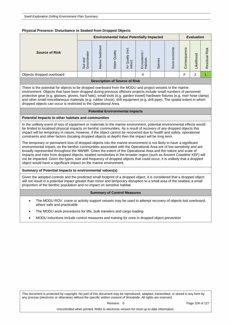
Swell Exploration Drilling Environment Plan Summary
This document is protected by copyright. No part of this document may be reproduced, adapted, transmitted, or stored in any form by any process (electronic or otherwise) without the specific written consent of Woodside. All rights are reserved.
Revision: 0 Page 104 of 127
Uncontrolled when printed. Refer to electronic version for most up to date information.
Physical Presence: Disturbance to Seabed from Dropped Objects
Source of Risk
Environmental Value Potentially Impacted Evaluation
Soil
and
Gro
undw
ate
r
Ma
rin
e S
edim
ent
Wate
r Q
ualit
y
Air Q
ualit
y (
incl.
odour)
Ecosyste
ms /
Habitats
Specie
s
Socio
-econom
ic
Co
nse
qu
ence
Lik
elih
oo
d
Re
sid
ua
l R
isk
Objects dropped overboard X F 2 L
Description of Source of Risk
There is the potential for objects to be dropped overboard from the MODU and project vessels to the marine environment. Objects that have been dropped during previous offshore projects include small numbers of personnel protective gear (e.g. glasses, gloves, hard hats), small tools (e.g. garden trowel) hardware fixtures (e.g. riser hose clamp) and other small miscellaneous materials (e.g. rubber chock), drill equipment (e.g. drill pipe). The spatial extent in which dropped objects can occur is restricted to the Operational Area.
Potential Environmental Impacts
Potential Impacts to other habitats and communities
In the unlikely event of loss of equipment or materials to the marine environment, potential environmental effects would be limited to localised physical impacts on benthic communities. As a result of recovery of any dropped objects this impact will be temporary in nature, however, if the object cannot be recovered due to health and safety, operational constraints and other factors (locating dropped objects at depth) then the impact will be long term.
The temporary or permanent loss of dropped objects into the marine environment is not likely to have a significant environmental impact, as the benthic communities associated with the Operational Area are of low sensitivity and are broadly represented throughout the NWMR. Given the extent of the Operational Area and the nature and scale of impacts and risks from dropped objects, seabed sensitivities in the broader region (such as Ancient Coastline KEF) will not be impacted. Given the types, size and frequency of dropped objects that could occur, it is unlikely that a dropped object would have a significant impact on the marine environment.
Summary of Potential Impacts to environmental values(s)
Given the adopted controls and the predicted small footprint of a dropped object, it is considered that a dropped object will not result in a potential impact greater than minor and temporary disruption to a small area of the seabed, a small proportion of the benthic population and no impact on sensitive habitat.
Summary of Control Measures
The MODU ROV, crane or activity support vessels may be used to attempt recovery of objects lost overboard, where safe and practicable
The MODU work procedures for lifts, bulk transfers and cargo loading
MODU inductions include control measures and training for crew in dropped object prevention

Swell Exploration Drilling Environment Plan Summary
This document is protected by copyright. No part of this document may be reproduced, adapted, transmitted, or stored in any form by any process (electronic or otherwise) without the specific written consent of Woodside. All rights are reserved.
Revision: 0 Page 105 of 127
Uncontrolled when printed. Refer to electronic version for most up to date information.
APPENDIX B: CONTROL MITIGATION MEASURES FOR POTENTIAL ENVIRONMENTAL IMPACTS ASSOCIATED WITH SPILL RESPONSE ACTIVITIES

Swell Exploration Drilling Environment Plan Summary
This document is protected by copyright. No part of this document may be reproduced, adapted, transmitted, or stored in any form by any process (electronic or otherwise) without the specific written consent of Woodside. All rights are reserved.
Revision: 0 Page 106 of 127
Uncontrolled when printed. Refer to electronic version for most up to date information.
Source Control
Impacts and Risks Evaluation Summary
Response Strategy
Environmental Value Potentially Impacted Evaluation
So
il &
Gro
un
dw
ate
r
Ma
rine
Se
dim
en
t
Qu
alit
y
Wa
ter
Qu
alit
y
Air
Qu
alit
y
Eco
syste
ms/H
ab
ita
t
Sp
ecie
s
So
cio
-Eco
no
mic
AL
AR
P T
oo
ls3
Accep
table
Source Control X X X X X X Good Practice
Professional Judgement Yes
Previously Assessed Environmental Risks
The risks and impacts of drilling a relief well are similar to those described in the EP for drilling activities. The remaining risks to the environment from vessel activities associated with the implementation of the Source control response fall within the scope of the EP (Appendix A), including:
Atmospheric emissions – Appendix A
Routine and non-routine discharges – Appendix A
Physical presence, proximity to other vessels (shipping and fisheries)- Appendix A
Routine acoustic emissions – Appendix A
Lighting for night work/navigational safety – Appendix A
Invasive marine species – Appendix A
Collision with marine fauna- Appendix A
Disturbance to Seabed – Appendix A
Refer to the Appendix A for details regarding how these risks are being managed to an ALARP and acceptable level.
*Note, any additional controls and environmental performance outcomes relating to these risks that are not presented in the EP but are specific to the source control response are presented below.
Description of Source of Risk
In the event of a worst case loss of well containment, source control would be the primary response strategy to reduce the volume of hydrocarbons released, potentially involving the following activities:
Vessel based deployment of the subsea first response toolkit (SFRT) to facilitate debris clearance by ROV
Vessel based deployment of a capping stack
Well intervention/relief well drilling.
Impact Assessment
Potential Impacts to water quality, air quality, protected species, socio-economic and protected areas
An environmental impact assessment, controls, environmental performance standards and measurement criteria for the sources of risk within the scope of the EP (as stated above) are detailed in the Section 5. Implementing a source control
response strategy will not result in a potential impact greater than localised, minor and temporary contamination above background levels and/or standards with localised, minor/negligible and temporary impacts to habitats or populations.
Summary of Adopted Controls
Woodside has arrangements through its external memberships, external arrangements, and internal arrangements to implement Source Control.
Woodside will activate source control if Net Environmental Benefit is identified through the Operational NEBA.
Woodside will terminate Source control in accordance with predetermined criteria:
3 Refer to Section 2.3.5 of the EP for ALARP tool definitions
Swell Exploration Drilling Environment Plan Summary
This document is protected by copyright. No part of this document may be reproduced, adapted, transmitted, or stored in any form by any process (electronic or otherwise) without the specific written consent of Woodside. All rights are reserved.
Revision: 0 Page 107 of 127
Uncontrolled when printed. Refer to electronic version for most up to date information.
o As per the OPEA Australia
o When the NEBA identifies there is no net environmental benefit
o Termination is validated through operational and scientific monitoring.
Woodside will investigate and report in accordance with regulatory requirements and Woodside’s Event Reporting and Investigation Operating Standard.

Swell Exploration Drilling Environment Plan Summary
This document is protected by copyright. No part of this document may be reproduced, adapted, transmitted, or stored in any form by any process (electronic or otherwise) without the specific written consent of Woodside. All rights are reserved.
Revision: 0 Page 108 of 127
Uncontrolled when printed. Refer to electronic version for most up to date information.
Monitor and Evaluate
Impacts and Risks Evaluation Summary
Response Strategy
Environmental Value Potentially Impacted Evaluation
So
il an
d
Gro
un
dw
ate
r
Ma
rine
Se
dim
en
t
Qu
alit
y
Wa
ter
Qu
alit
y
Air
Qu
alit
y
Eco
syste
ms/H
ab
ita
t
Sp
ecie
s
So
cio
-Eco
no
mic
AL
AR
P T
oo
ls4
Accep
table
Monitor and Evaluate
X X X X X X
Good Practice
Professional Judgement
Eliminate
Yes
Previously Assessed Environmental Risks
Field-based activities undertaken during the Monitor and Evaluate Response Strategy including monitoring, surveillance and reconnaissance involving vessel, aircraft operations, and shoreline surveys present risks to the environment. Several of these risks have been previously assessed within the scope of the EP (Appendix A) including;
Atmospheric emissions – Appendix A
Routine and non-routine discharges – Appendix A
Helicopter Activities - localised disturbance to marine species – Appendix A
Physical presence, proximity to other vessels (shipping and fisheries)- Appendix A
Routine acoustic emissions – Appendix A
Lighting for night work/navigational safety – Appendix A
Invasive marine species – Appendix A
Collision with marine fauna- Appendix A
Refer to the Appendix A for details regarding how these risks are being managed to an ALARP and acceptable level
*Note, any additional controls and environmental performance outcomes relating to these risks that are not presented in the EP but are specific to the monitor and evaluate response are presented below.
Description of Source of Risk
Additional risks associated with the monitor and evaluate response not included within the scope of the EP include:
Seabed disturbance that may be associated with Vessel anchoring
During the implementation of response strategies, where water depths allow, it is possible that response vessels will be required to anchor (e.g. during shoreline surveys). The use of vessel anchoring will be minimal, and likely to occur when the impacted shoreline is inaccessible via road to shoreline response teams.
Presence of personnel during shoreline surveys resulting in disturbance to wildlife and habitats
During implementation of shoreline surveys associated with OM04, responders are required to survey shoreline receptor locations prior to contact from the hydrocarbon spill. As a result there is potential for environmental impacts associated with the presence of personal in environmentally sensitive locations.
Impact Assessment
Potential Impacts to water quality, air quality, protected species, socio-economic and protected areas
Seabed disturbance that may be associated with Vessel anchoring
Anchoring in the nearshore environment, such as the Priority Protection Areas (Ningaloo Coast and the Muiron Islands), will have potential to impact coral reef, seagrass beds and benthic communities in these areas. Impacts would be highly localised (restricted to the footprint of the vessel anchor) and temporary, with full recovery expected.
4 Refer to Section 2.3.5 of the EP for ALARP tool definitions

Swell Exploration Drilling Environment Plan Summary
This document is protected by copyright. No part of this document may be reproduced, adapted, transmitted, or stored in any form by any process (electronic or otherwise) without the specific written consent of Woodside. All rights are reserved.
Revision: 0 Page 109 of 127
Uncontrolled when printed. Refer to electronic version for most up to date information.
Presence of personnel during shoreline surveys resulting in disturbance to wildlife and habitats
the impacts associated with human presence on shorelines during shoreline surveys include:
Damage to vegetation/habitat in order to gain access to areas.
Damage or disturbance to wildlife and habitats during shoreline surveys.
Removal of surface layers of intertidal sediments (potential habitat depletion).
Excessive removal of substrate can have erosion and instability effects.
Summary of Adopted Controls
Woodside has arrangements through its external memberships, external arrangements, and internal arrangements to implement Monitor and Evaluate.
Woodside will activate and terminate Operational Monitoring plans in accordance with Woodside Operational Monitoring Operational Plan (W0000AH932960).
The use of existing mooring points or alternatively anchor locations will be assessed and selected during the Operational NEBA process.
Environmental impacts from shoreline surveys will be assessed during the Operational NEBA process.

Swell Exploration Drilling Environment Plan Summary
This document is protected by copyright. No part of this document may be reproduced, adapted, transmitted, or stored in any form by any process (electronic or otherwise) without the specific written consent of Woodside. All rights are reserved.
Revision: 0 Page 110 of 127
Uncontrolled when printed. Refer to electronic version for most up to date information.
Containment and Recovery
Impacts and Risks Evaluation Summary
Response Strategy
Environmental Value Potentially Impacted Evaluation
So
il &
Gro
un
dw
ate
r
Ma
rine
Se
dim
en
t
Qu
alit
y
Wa
ter
Qu
alit
y
Air
Qu
alit
y
Eco
syste
ms/H
ab
ita
t
Sp
ecie
s
So
cio
-Eco
no
mic
AL
AR
P T
oo
ls5
Accep
table
Containment and Recovery
X X X X X X Good Practice
Professional Judgement Yes
Previously Assessed Environmental Risks
Potential risks to the environment from activities associated with the containment and recovery response that are covered within the scope of the EP (Appendix A) include:
Atmospheric emissions – Appendix A
Routine and non-routine discharges – Appendix A
Helicopter Activities - localised disturbance to marine species – Appendix A
Physical presence, proximity to other vessels (shipping and fisheries)- Appendix A
Routine acoustic emissions – Appendix A
Lighting for night work/navigational safety – Appendix A
Invasive marine species – Appendix A
Collision with marine fauna- Appendix A
Refer to the Appendix A for details regarding how these risks are being managed to an ALARP and acceptable level
*Note, any additional controls and environmental performance outcomes relating to these risks that are not presented in the EP but are specific to the containment and recovery response are presented below.
Description of Source of Risk
A containment and recovery typically involves the deployment of boom and skimmers from suitable vessels, as well as the collection, transfer and disposal of oily water recovered during the response.
Additional risks associated with the containment and recovery response not included within the scope of the EP include:
Waste management leading to secondary contamination
It is possible for an unplanned release of recovered oily water to the marine environment causing secondary contamination during transfer, decanting or transport activities that form part of a containment and recovery response.
Response equipment obstructing wildlife
Containment and recovery equipment such as booms and skimmers have the potential to act as obstacles or trap wildlife.
Vessel anchoring – refer to vessel anchoring in Monitor and evaluate
Impact Assessment
Potential Impacts to water quality, air quality, protected species, socio-economic and protected areas
An environmental impact assessment, controls, environmental performance standards and measurement criteria for the sources of risk within the scope of the EP (as stated above) are detailed in the Appendix A.
An evaluation of the impacts not within the scope of the EP are as followed:
5 Refer to Section 2.3.5 of the EP for ALARP tool definitions
Swell Exploration Drilling Environment Plan Summary
This document is protected by copyright. No part of this document may be reproduced, adapted, transmitted, or stored in any form by any process (electronic or otherwise) without the specific written consent of Woodside. All rights are reserved.
Revision: 0 Page 111 of 127
Uncontrolled when printed. Refer to electronic version for most up to date information.
Secondary Contamination
Secondary contamination refers to the release of hydrocarbons back to the environment during a response (potentially during containment and recovery, oiled wildlife response and shoreline cleanup). The largest volume of oily water that could be spilt is conservatively considered to be 200 m3, i.e. the equivalent to the maximum oily water volume recovered from one containment and recovery operation per day. Given the application of a conservative bulking factor of 10 when calculating the hydrocarbon content of the oily water mixture, the maximum volume of hydrocarbon that could be released is 20 m3. The biological consequences of such a small volume spill on identified open water sensitive receptors would be expected to be similar to those associated with the unplanned release of hydrocarbons as a result of a bunkering scenario, and relate to the potential for minor impacts to megafauna, plankton and fish populations (surface and water column biota) that are within the spill affected area and no impacts to commercial fisheries are expected. Appendix A (potential impacts of unplanned hydrocarbon release to the marine environment
from vessel collision) describes the detailed potential impacts from a hydrocarbon spill; however, the extent of the ZoC associated with a spill of recovered oily water from a containment and recovery response will be much reduced in terms of spatial and temporal scales, and hence, the potential impacts are expected to be very minor.
Waste
Implementing the selected response strategies will result in the generation of the following waste streams that will require management and disposal:
Liquids (recovered oil/water mixture), recovered from containment and recovery operations
Semi-solids/solids (oily solids), collected during containment and recovery operations
Debris (e.g. seaweed, woods, plastics), collected during containment and recovery operations.
If not managed and disposed of correctly, wastes generated during the response have the potential for secondary contamination similar to that described above, impacts to wildlife through contact with or ingestion of waste materials and contamination risks if not disposed of correctly onshore.
Response equipment obstructing wildlife
Typical booms used in containment and recovery operations are designed to sit on the water surface, meaning that fauna capable of diving, such as cetaceans, marine turtles and seasnakes can readily avoid contact with the boom. Impacts to species that inhabit the water column such as sharks, rays and fish are not expected. Additionally, many fauna, such as cetaceans, are likely to detect and avoid the spill area, and are not expected to be present in the proximity of containment and recovery operations.
Vessel anchoring – refer to vessel anchoring in Operational monitoring
Summary of Adopted Controls
Woodside maintains access to equipment to adequately implement and scale a containment and recovery response throughout the response period.
Woodside maintains access to trained personnel to adequately implement and scale a containment and recovery response throughout the response period.
A licensed waste service provider to transport, dispose and treat waste generated during containment and recovery operations to limit secondary contamination and appropriately manage any waste generated.
Containment and recovery operations will be activated via the first strike plan (when operational monitoring identifies surface hydrocarbons are present), provided net environmental benefit is identified through the Operational NEBA.
If there is net environmental benefit to do so, decanting of oily water will be undertaken to reduce waste volume.
If there is net environmental benefit vessels returning to port that are involved in oil spill response operations may be washed to reduce the risk of secondary contamination.
When the recovery effort outweighs the benefit and therefore no environmental benefit is identified through the operational NEBA, containment and recovery operations will be terminated.

Swell Exploration Drilling Environment Plan Summary
This document is protected by copyright. No part of this document may be reproduced, adapted, transmitted, or stored in any form by any process (electronic or otherwise) without the specific written consent of Woodside. All rights are reserved.
Revision: 0 Page 112 of 127
Uncontrolled when printed. Refer to electronic version for most up to date information.
Wildlife Response
Impacts and Risks Evaluation Summary
Response Strategy
Environmental Value Potentially Impacted Evaluation
So
il &
Gro
un
dw
ate
r
Ma
rine
Se
dim
en
t
Qu
alit
y
Wa
ter
Qu
alit
y
Air
Qu
alit
y
Eco
syste
ms/H
ab
ita
t
Sp
ecie
s
So
cio
-Eco
no
mic
AL
AR
P T
oo
ls6
Accep
table
Wildlife Response X X X X X X
Good Practice
Professional Judgement
Yes
Previously Assessed Environmental Risks
Potential risks to the environment from activities associated with the oiled wildlife response that are covered within the scope of the EP (Appendix A), include:
Atmospheric emissions – Appendix A
Routine and non-routine discharges – Appendix A
Physical presence, proximity to other vessels (shipping and fisheries)- Appendix A
Routine acoustic emissions – Appendix A
Lighting for night work/navigational safety – Appendix A
Invasive marine species – Appendix A
Collision with marine fauna- Appendix A
Refer to the Appendix A for details regarding how these risks are being managed to an ALARP and acceptable level
*Note, any additional controls and environmental performance outcomes relating to these risks that are not presented in the EP but are specific to the wildlife response are presented below.
Description of Source of Risk
An oiled wildlife response would involve reconnaissance from vessels, aircraft and shoreline surveys, the capture, transport, rehabilitation and release of oiled wildlife.
Additional risks associated with the containment and recovery response not included within the scope of the EP include:
Impacts to wildlife through:
Capturing wildlife
Transporting wildlife
Stabilisation of wildlife
Cleaning and rinsing of oiled wildlife
Rehabilitation (e.g. diet, cage size, housing density)
Release of treated wildlife
Hazing of wildlife
Shoreline surveys – risks associated with shoreline surveys are assessed in Operational monitoring
Waste generation and disposal – Refer to waste generation and disposal in Section Waste Management
Presence of personnel – risks associated with presence of personnel are covered in Oiled Wildlife
Impact Assessment
Potential Impacts to water quality, air quality, protected species, socio-economic and protected areas
An environmental impact assessment, controls, environmental performance standards and measurement criteria for
6 Refer to Section 2.3.5 of the EP for ALARP tool definitions

Swell Exploration Drilling Environment Plan Summary
This document is protected by copyright. No part of this document may be reproduced, adapted, transmitted, or stored in any form by any process (electronic or otherwise) without the specific written consent of Woodside. All rights are reserved.
Revision: 0 Page 113 of 127
Uncontrolled when printed. Refer to electronic version for most up to date information.
the sources of risk within the scope of the EP (as stated above) are detailed in the Section 5.
An evaluation of the impacts not within the scope of the EP are as followed:
Impacts to Wildlife
Capturing wildlife
o Inefficient capture techniques has potential to cause undue stress, exhaustion or injury to wildlife.
o Pre-emptive capture could cause undue impacts when oiling is not certain.
Transportation
o Inefficient transport techniques has potential to cause undue injury, stress and thermoregulation pressures to wildlife.
Stabilisation of wildlife
o Inefficient stabilisation of wildlife techniques has potential to cause injury to wildlife and thermoregulation stress, In addition to potential for euthanasia during the triage process.
Cleaning and rinsing of oiled wildlife
o Inefficient cleaning and rinsing techniques has potential to cause injury and exhaustion of wildlife with potential to remove water-proofing feathers.
Rehabilitation (e.g. diet, cage size, housing density)
o Inefficient rehabilitation techniques has potential to cause injury and thermoregulation stress of wildlife. Additionally, inappropriate captive diet could result in further injury to wildlife.
Release of treated wildlife
o Potential for undue stress to wildlife if released in an unfamiliar site.
o Potential for rehabilitated wildlife to return to the oiled area of capture.
o Potential of stress adjusting to the release site.
Hazing of wildlife
o Inefficient hazing techniques has the potential to cause undue stress to wildlife.
o Potential for wildlife to return to area post hazing which could result in further hazing being required or could lead to impacts from the spill if it coincides with the spill hitting the location.
o Potential for wildlife to relocate to an undesired location where potential for impacts to wildlife are greater than the initial location.
Shoreline surveys – risks associated with shoreline surveys are assessed in Operational monitoring
Waste generation and disposal – Refer to waste generation and disposal in Section Waste Management
Presence of personnel – risks associated with presence of personnel are covered in Oiled Wildlife
Summary of Adopted Controls
Access to trained personal to adequately implement an oiled wildlife response.
Access to equipment to adequately implement an oiled wildlife response.
A licensed waste service provider to transport, dispose and treat waste generated during containment and recovery operations to limit secondary contamination and appropriately manage any waste generated.
Oiled wildlife operations will be activated via the first strike plan (when operational monitoring suggests potential for oiled wildlife to occur), provided net environmental benefit is identified through the Operational NEBA.
Woodside pre identifies suitable oiled wildlife response wildlife tactics for the response stages adopted from the Oiled Wildlife Response Plan.
Any deterrence/hazing/pre-emptive capture activities require licensing authority from the DPaW and operational approval from the IC.
Environmental impacts from shoreline surveys will be assessed during the NEBA process to ensure net environmental benefit is achieved.
Oiled wildlife response will be terminated when the effort outweighs the benefit to conduct oiled wildlife operations (no net environmental benefit identified through the Operational NEBA).
Shoreline Cleanup
Swell Exploration Drilling Environment Plan Summary
This document is protected by copyright. No part of this document may be reproduced, adapted, transmitted, or stored in any form by any process (electronic or otherwise) without the specific written consent of Woodside. All rights are reserved.
Revision: 0 Page 114 of 127
Uncontrolled when printed. Refer to electronic version for most up to date information.
Impacts and Risks Evaluation Summary
Response Strategy
Environmental Value Potentially Impacted
Evaluation
So
il &
Gro
un
dw
ate
r M
ari
ne
Se
dim
en
t
Qu
alit
y
Wa
ter
Qu
alit
y
Air
Qu
alit
y
Eco
syste
ms/H
ab
ita
t
Sp
ecie
s
So
cio
-Eco
no
mic
AL
AR
P T
oo
ls7
Accep
table
Shoreline Cleanup X X X X X X X
Good Practice
Professional Judgement
Yes
Previously Assessed Environmental Risks
Potential risks to the environment from activities associated with the shoreline clean up response that are covered within the scope of the EP (Appendix A), include:
Atmospheric emissions – Appendix A
Routine acoustic emissions – Appendix A
Lighting for night work/navigational safety – Appendix A
Refer to the Appendix A for details regarding how these risks are being managed to an ALARP and acceptable
level.
*Note, any additional controls and environmental performance outcomes relating to these risks that are not presented in the EP but are specific to the shoreline cleanup are presented below.
Description of Source of Risk
Shoreline cleanup consists of different manual and mechanical recovery techniques to remove hydrocarbons and contaminated debris from a shoreline to minimise ongoing environmental contamination and impact. Shoreline cleanup techniques recommended for different shoreline types and conditions that are considered to have a net environmental benefit for this Petroleum Activities Program include manual and mechanical cleanup (Appendix A).
Additional risks associated with the shoreline cleanup response not included within the scope of the EP include:
Mechanical cleaning
Human Presence (manual cleaning)
Sediment reworking
Vegetation cutting.
Waste generation and disposal – Refer to waste generation and disposal in containment and recovery
Impact Assessment
Potential Impacts to water quality, air quality, protected species, socio-economic and protected areas
An environmental impact assessment, controls, environmental performance standards and measurement criteria for the sources of risk within the scope of the EP (as stated above) are detailed in the Appendix A
An evaluation of the impacts not within the scope of the EP are as followed:
Mechanical cleaning
o Damage to shoreline from machinery.
o Compaction of sediment from heavy machinery causing hydrocarbons to be buried or
7 Refer to Section 2.3.5 of the EP for ALARP tool definitions

Swell Exploration Drilling Environment Plan Summary
This document is protected by copyright. No part of this document may be reproduced, adapted, transmitted, or stored in any form by any process (electronic or otherwise) without the specific written consent of Woodside. All rights are reserved.
Revision: 0 Page 115 of 127
Uncontrolled when printed. Refer to electronic version for most up to date information.
penetrate sediment further.
o Damage to vegetation/habitat in order to gain access for heavy machinery to area.
o Removal of surface layers of intertidal sediments (potential habitat depletion).
o Excessive removal of substrate can have erosion and instability effects.
Human Presence (manual cleaning)
o Compaction of human presence causing hydrocarbons to be buried or penetrate sediment
further.
o Damage to vegetation/habitat in order to gain access to areas.
o Removal of surface layers of intertidal sediments (potential habitat depletion).
o Excessive removal of substrate can have erosion and instability effects.
Sediment reworking
o Remobilised oil could have impacts elsewhere causing secondary contamination.
Vegetation cutting
o Cutting back too much vegetation could allow more oil to penetrate substrate.
o Removing too much vegetation or slow growing vegetation can have negative impact for
wildlife (habitat loss).
Waste generation and disposal – Refer to waste generation and disposal in Containment and recovery
Summary of Adopted Controls
Access to equipment to adequately implement a shoreline cleanup response.
Access to trained personal to adequately implement a shoreline cleanup response
A licensed waste service provider to transport, dispose and treat waste generated during containment and recovery operations to limit secondary contamination and appropriately manage any waste generated.
Shoreline cleanup operations will be activated via the first strike plan (when operational monitoring identifies shoreline contact above threshold is predicted), provided net environmental benefit is identified through the Operational NEBA.
Woodside has pre-determined shoreline clean up techniques used for the range of shoreline types which could potentially be contacted during a well loss of containment scenario.
When the recovery effort outweighs the benefit and therefore no net environmental benefit is identified through the operational NEBA, shoreline clean-up will be terminated.

Swell Exploration Drilling Environment Plan Summary
This document is protected by copyright. No part of this document may be reproduced, adapted, transmitted, or stored in any form by any process (electronic or otherwise) without the specific written consent of Woodside. All rights are reserved.
Revision: 0 Page 116 of 127
Uncontrolled when printed. Refer to electronic version for most up to date information.
Waste Management
Impacts and Risks Evaluation Summary
Response Strategy
Environmental Value Potentially Impacted Evaluation
So
il &
Gro
un
dw
ate
r
Ma
rine
Se
dim
en
t
Qu
alit
y
Wa
ter
Qu
alit
y
Air
Qu
alit
y
Eco
syste
ms/H
ab
ita
t
Sp
ecie
s
So
cio
-Eco
no
mic
AL
AR
P T
oo
ls8
Accep
table
Waste Management X X X X X X X
Good Practice
Professional Judgement
Yes
Previously Assessed Environmental Risks
Potential risks to the environment from activities associated with the waste management response that are covered within the scope of the EP (Appendix A), include:
Atmospheric emissions – Appendix A
Routine acoustic emissions – Appendix A
Lighting for night work/navigational safety – Appendix A
*Note, any additional controls and environmental performance outcomes relating to these risks that are not presented in the EP but are specific to the shoreline cleanup are presented below.
Description of Source of Risk
Secondary Contamination:
Secondary contamination of habitat is possible throughout the waste management cycle from temporary storage and transport, to treatment and disposal. This can be caused by the following:
Ineffective waste management methods
Use of faulty equipment
Use of unfamiliar equipment
Use of unsuitable equipment
Transferring waste between storage types.
Impact Assessment
Potential Impacts to water quality, air quality, protected species, socio-economic and protected areas
8 Refer to Section 2.3.5 of the EP for ALARP tool definitions

Swell Exploration Drilling Environment Plan Summary
This document is protected by copyright. No part of this document may be reproduced, adapted, transmitted, or stored in any form by any process (electronic or otherwise) without the specific written consent of Woodside. All rights are reserved.
Revision: 0 Page 117 of 127
Uncontrolled when printed. Refer to electronic version for most up to date information.
An environmental impact assessment, controls, environmental performance standards and measurement criteria for the sources of risk within the scope of the EP (as stated above) are detailed in the Appendix A.
Secondary Contamination
Temporary storage and transport
Use of faulty storage equipment could cause secondary contamination through leakages into previously unaffected areas.
Inadequate storage methods could increase the potential for secondary contamination to occur through spills due to the need for more frequent transport from temporary storage.
Treatment and Disposal
Ineffective treatment and disposal methods could result in secondary contamination.
Transferring waste
Secondary contamination could occur during the transferring of waste associated with the waste management cycle from temporary storage and transport, to treatment and disposal.
Summary of Adopted Controls
Woodside has a contact with a licenced waste management provider ensuring:
o adequate equipment and trained personal for the waste management response
o Immediate and intermediate waste storage capability
o Plans for handling, storage and transport of all waste types during a response
o Waste management is conducted in accordance with relevant standards and legislation
o Waste remediation options to reduce volumes to landfill or incineration.
Waste will be treated using pre-determined strategies via the contact with Veolia.
Waste will be managed in accordance to the Waste Management Support Plan (W0000AH967579 which includes:
o Immediate and intermediate waste storage capability
o Plans for handling, storage and transport of all waste types during a response.
o Waste remediation options to reduce volumes to landfill or incineration.
Bulk transport to Veolia’s licensed waste management facilities would be undertaken via controlled-waste-licensed vehicles and in accordance with Environmental Protection (Controlled Waste) Regulations 2004.

Swell Exploration Drilling Environment Plan Summary
This document is protected by copyright. No part of this document may be reproduced, adapted, transmitted, or stored in any form by any process (electronic or otherwise) without the specific written consent of Woodside. All rights are reserved.
Revision: 0 Page 118 of 127
Uncontrolled when printed. Refer to electronic version for most up to date information.
APPENDIX C: SUMMARY OF STAKEHOLDER FEEDBACK AND WOODSIDE’S ASSESSMENTS AND REPONSES

Swell Exploration Drilling Environment Plan Summary
This document is protected by copyright. No part of this document may be reproduced, adapted, transmitted, or stored in any form by any process (electronic or otherwise) without the specific written consent of Woodside. All rights are reserved.
Revision: A Page 119 of 127
Uncontrolled when printed. Refer to electronic version for most up to date information.
Relevant Stakeholder feedback for the Petroleum Activities Program
Organisation Method Feedback Woodside assessment Woodside’s Response
Department of Industry Innovation and Science
Email with fact sheet Date: 19 July 2016
Feedback summary: No response at the time of submission.
Woodside will accept and assess feedback from stakeholder post EP submission to NOPSEMA.
Response/Action:
No further action required.
Department of Mines and Petroleum
Email with fact sheet Date: 9 August 2016
Feedback summary: The Department advised via email that it had received Woodside’s advice about the drilling activity and did not require additional information at this stage.
The Department requested notification upon completion of the activities.
The Department provided its Consultation Guidance Note for reference and requested Woodside also review the Department of Transport’s Dispersant Use Guidelines.
The Department acknowledged that the NOPSEMA will assess the proposed activity in accordance with the Offshore Petroleum and
The stakeholder raised no claims or objections. Woodside to provide cessation notification at the end of the activity. Woodside to review the referenced documents.
Response/Action:
Woodside to provide cessation notification at the end of the activity.

Swell Exploration Drilling Environment Plan Summary
This document is protected by copyright. No part of this document may be reproduced, adapted, transmitted, or stored in any form by any process (electronic or otherwise) without the specific written consent of Woodside. All rights are reserved.
Revision: A Page 120 of 127
Uncontrolled when printed. Refer to electronic version for most up to date information.
Greenhouse Gas Storage (Environment) Regulations 2009.
Australian Maritime Safety Authority (marine safety)
Teleconference and email Date: 20 July 2016
Feedback summary:
The Authority provided two AIS traffic plots and advised on vessel traffic to be expected in the area near the Swell exploration well.
The Authority advised on the communication requirements between the MODU and support vessels with nearby commercial shipping.
The Authority requested that the MODU notify AMSA’s Joint Rescue Coordination Centre (JRCC) 24-48 hours before operations commence and provided the details required.
The Authority advised that the Australian Hydrographic Service must be contacted no less than four weeks before operations commence to commence related Notices
Woodside acknowledges the Authority’s advice regarding expected traffic in the area and its communication requirements.
Response/Action:
Woodside to observe communication requirements for vessel interactions. Requested advice to be supplied to AMSA’s JRCC and AHS within outline timeframes.

Swell Exploration Drilling Environment Plan Summary
This document is protected by copyright. No part of this document may be reproduced, adapted, transmitted, or stored in any form by any process (electronic or otherwise) without the specific written consent of Woodside. All rights are reserved.
Revision: A Page 121 of 127
Uncontrolled when printed. Refer to electronic version for most up to date information.
To Mariners.
Australian Hydrographic Service (AHS)
Teleconference and email Date: 20 July 2016
Feedback summary:
AHS confirmed receipt of Woodside’s advice via email.
The stakeholder raised no claims or objections.
Response/Action:
No further action required
Department of Fisheries (Western Australia)
Letter Date: 19 August 2016
Feedback summary: The Department confirmed via letter that it considers itself a relevant person for the proposed activity.
The Department advised that its advice remains valid should the proposed activity commence within six months, otherwise advice may be updated.
The Department requests to receive notification from Woodside that activities are planned to commence, no less than three months before the proposed start date.
The Department recommends Woodside engages with WAFIC, Pearl Producers Association, Recfishwest, fishing licence holders and the Department of Parks
Woodside acknowledged the Department’s advice via letter on 4 October.
Woodside acknowledged the timeframe that the Department’s advice remains valid.
Woodside confirmed the stakeholders that it had engaged and will continue to engage with about the proposed activity.
In the unlikely event of an oil spill or discharge into the environment, Woodside will notify relevant agencies and organisations as appropriate to the nature and scale of the event, as soon as practicable following the occurrence.
Woodside selects oil spill response strategies based on Net Environmental Benefit Analysis (NEBA).
Response/Action:
Woodside to address all relevant potential impacts to fisheries, fish and fish habitats in the environment plan, as described in the Departments’ letter. If necessary Woodside will notify the Department of Fisheries three months prior to the commencement of the Petroleum Activity Program.

Swell Exploration Drilling Environment Plan Summary
This document is protected by copyright. No part of this document may be reproduced, adapted, transmitted, or stored in any form by any process (electronic or otherwise) without the specific written consent of Woodside. All rights are reserved.
Revision: A Page 122 of 127
Uncontrolled when printed. Refer to electronic version for most up to date information.
and Wildlife.
The Department provided a list of commercial fisheries that exist in, or in close proximity to permit WA-483-P.
The Department requested contact by phone and email in the event of a hydrocarbon spill within 24 hours of Woodside reporting the incident to the relevant Authority.
The Department requested that specific strategies are developed in the EP to mitigate impacts on fish spawning. A list of fish species was provided.
The Department recommended resources for Woodside to demonstrate it has taken reasonable measures to reduce its chances of carrying out offences under the Fish Resources Management Act 1994 and associated regulations.
The Department
The NEBA process takes into account potential benefits/impacts of response strategies to all environmental sensitivities.
Woodside confirms that the NEBA process includes analysis of potential benefits/impacts of spawning grounds and nursery areas.
Woodside ensures compliance with biosecurity requirements through its implementation of its own Invasive Marine Species Management Plan, which is supported at a Commonwealth level.
This process demonstrates compliance with the Fish Resources Management Act 1994.
Woodside strongly encourages its contractors to use the Department’s Vessel Check tool to proactively manage Invasive Marine Species risk when not on contract to the company.
Woodside advised that

Swell Exploration Drilling Environment Plan Summary
This document is protected by copyright. No part of this document may be reproduced, adapted, transmitted, or stored in any form by any process (electronic or otherwise) without the specific written consent of Woodside. All rights are reserved.
Revision: A Page 123 of 127
Uncontrolled when printed. Refer to electronic version for most up to date information.
requested that suspected or confirmed marine pest or disease is report within 24 hours.
The Department requests all potential impacts and Woodside strategies to mitigate are identified in the final EP.
The Department requested a written response from Woodside addressing all concerns raised in its letter.
suspected or confirmed presence of marine pest or disease will be reported to the Department within 24 hours.
Commonwealth fisheries
Western Skipjack Fishery
Western Tuna and Billfish Fishery
North-West Slope Trawl Fishery
Southern Bluefin Tuna Fishery
Western Deepwater Trawl Fishery
Email with fact sheet and map
Date: 19 July 2016
Feedback summary: No response at the time of submission.
Woodside will accept and assess feedback from stakeholder post EP submission to NOPSEMA.
Response/Action:
No further action required.
Western Australian Fisheries
Mackerel Fishery
Pilbara Trawl Fishery
Pilbara Trap Fishery
Email with fact sheet and map
Letter with fact sheet and map
Date: 19 July 2016
Feedback summary: No response at the time of submission.
Woodside will accept and assess feedback from stakeholder post EP submission to NOPSEMA.
Response/Action:
No further action required.

Swell Exploration Drilling Environment Plan Summary
This document is protected by copyright. No part of this document may be reproduced, adapted, transmitted, or stored in any form by any process (electronic or otherwise) without the specific written consent of Woodside. All rights are reserved.
Revision: A Page 124 of 127
Uncontrolled when printed. Refer to electronic version for most up to date information.
Department of Transport Email with fact sheet
Draft First strike plan
Date: 17 October 2016
Feedback summary: Fact sheet provided to stakeholder on 19 July 2016 and Oil Pollution First Strike Plan provided on 18 October 2016.
No response was received at the time of submission.
Woodside will accept and assess feedback from stakeholder post EP submission to NOPSEMA.
Response/Action:
No further action required.
Western Australian Fishing Industry Council (WAFIC)
Teleconference Date: 20 July 2016
Feedback summary:
WAFIC advised via email that it noted Woodside will liaise directly with all commercial fishers actively operating in the proposed area. WAFIC requested that Woodside notify all active fishers in the area when the activity is to commence in Q2 2017 and the approximate activity duration. WAFIC noted the 500 m exclusion zone, however expressed concern that the 2.5 km radius precautionary zone imposed additional restrictions on marine users. WAFIC requested Woodside define the precautionary zone and
Woodside confirmed it provided commercial fisheries a copy of the activity fact sheet and map. Woodside advised that early notification will be provided to fishers in the area about activity start times and durations. Woodside confirmed that the 500 m exclusion zone restricts marine users from entering, whereas the 2.5 km precautionary zone (also known as the safety zone) is a precautionary zone that marine users can enter (noting that there will be a concentrated level of activity taking place in the area). Woodside advised that the MODU moorings may pose a temporary and
Date: 26 July 2016
Response/Action:
Woodside to provide early notification about activity start dates and duration to commercial fishers operating in the area.

Swell Exploration Drilling Environment Plan Summary
This document is protected by copyright. No part of this document may be reproduced, adapted, transmitted, or stored in any form by any process (electronic or otherwise) without the specific written consent of Woodside. All rights are reserved.
Revision: A Page 125 of 127
Uncontrolled when printed. Refer to electronic version for most up to date information.
advise on its prohibitions. WAFIC advised it was reluctant to support additional unnecessary restrictions which restrict commercial fishing activities as a consequence of the drilling activity. WAFIC made reference to another oil and gas operator who only requested a 500 m radius exclusion zone.
short-term interference to commercial trawling and line fishing operations occurring in the area, although there are no restrictions on vessel movements within the precautionary zone, but are outside the 500m exclusion zone.
Pearl Producers Association
Email with fact sheet Date: 19 July 2016
Feedback summary: No response at the time of submission.
Woodside will accept and assess feedback from stakeholder post EP submission to NOPSEMA.
Response/Action:
No further action required.
North West Cape Exmouth Aboriginal Corporation (member of Exmouth CRG)
Email with fact sheet Date: 5 August 2016
Feedback summary: The stakeholder thanked Woodside for its email.
The stakeholder raised no claims or objections.
Response/Action:
No further action required.

Swell Exploration Drilling Environment Plan Summary
This document is protected by copyright. No part of this document may be reproduced, adapted, transmitted, or stored in any form by any process (electronic or otherwise) without the specific written consent of Woodside. All rights are reserved.
Revision: A Page 126 of 127
Uncontrolled when printed. Refer to electronic version for most up to date information.
Interested Stakeholder feedback for the Petroleum Activities Program
Organisation Method Feedback Woodside assessment Woodside’s Response
Australian Maritime Safety Authority (marine pollution)
Email with fact sheet
First Strike Plan
Date: 18 October 2016
Feedback summary: Fact sheet provided to stakeholder on 19 July 2016 and Oil Pollution First Strike Plan provided on 18 October 2016.
No response was received at the time of submission.
Woodside will accept and assess feedback from stakeholder post EP submission to NOPSEMA.
Response/Action:
No further action required.
Attached: Appendix F
Department of Parks and Wildlife
Email with fact sheet Date: 19 July 2016
Feedback summary: No response at the time of submission.
Woodside will accept and assess feedback from stakeholder post EP submission to NOPSEMA.
Response/Action:
No further action required.
Australian Customs Service – Border Protection Command
Email with fact sheet Date: 19 July 2016
Feedback summary: No response at the time of submission.
Woodside will accept and assess feedback from stakeholder post EP submission to NOPSEMA.
Response/Action:
No further action required.
Commonwealth Fisheries Association
Email with fact sheet Date: 19 July 2016
Feedback summary: No response at the time of submission.
Woodside will accept and assess feedback from stakeholder post EP submission to NOPSEMA.
Response/Action:
No further action required.
Recfishwest Email with fact sheet Date: 19 July 2016
Feedback summary: No response at the time of submission.
Woodside will accept and assess feedback from stakeholder post EP submission to NOPSEMA.
Response/Action:
No further action required.
Swell Exploration Drilling Environment Plan Summary
This document is protected by copyright. No part of this document may be reproduced, adapted, transmitted, or stored in any form by any process (electronic or otherwise) without the specific written consent of Woodside. All rights are reserved.
Revision: A Page 127 of 127
Uncontrolled when printed. Refer to electronic version for most up to date information.
WWF Email with fact sheet Date: 19 July 2016
Feedback summary: No response at the time of submission.
Woodside will accept and assess feedback from stakeholder post EP submission to NOPSEMA.
Response/Action:
No further action required.
Australian Conservation Foundation
Email with fact sheet Date: 19 July 2016
Feedback summary: No response at the time of submission.
Woodside will accept and assess feedback from stakeholder post EP submission to NOPSEMA.
Response/Action:
No further action required.
Wilderness Society Email with fact sheet Date: 19 July 2016
Feedback summary: No response at the time of submission.
Woodside will accept and assess feedback from stakeholder post EP submission to NOPSEMA.
Response/Action:
No further action required.
International Fund for Animal Welfare
Email with fact sheet Date: 19 July 2016
Feedback summary: No response at the time of submission.
Woodside will accept and assess feedback from stakeholder post EP submission to NOPSEMA.
Response/Action:
No further action required.
APPEA Email with fact sheet Date: 19 July 2016
Feedback summary: No response at the time of submission.
Woodside will accept and assess feedback from stakeholder post EP submission to NOPSEMA.
Response/Action:
No further action required.
AMOSC Email with fact sheet Date: 19 July 2016
Feedback summary: No response at the time of submission.
Woodside will accept and assess feedback from stakeholder post EP submission to NOPSEMA.
Response/Action:
No further action required.