Embed Size (px)
Citation preview
Rationale
SYLLABUS
GEOGRAPHY (CODE NO. 029)
CLASS-XII (2012-13)
Geography is introduced as an elective subject at the senior secondary stage. After ten years of
general education, students branch out at the beginning of this stage and are exposed to the rigours of
the discipline for the first time. Being an entry point for the higher education, students choose geography
for pursuing their academic interest and, therefore, need a broader and deeper understanding of the
subject. For others, geographical knowledge is useful in daily lives because it is a valuable medium for
the education of young people. Its contribution lies in the content, cognitive processes, skills and values
that geography promotes and thus helps the students explore, understand and evaluate the environmental
and social dimensions of the world in a better manner.
Since geography explores the relationship between people and their environment, it includes
studies of physical and human environments and their interactions at different scales-local, state/region,
nation and the world. The fundamental principles responsible for the varieties in the distributional
pattern of physical and human features and phenomena over the earth’s surface need to be understood
properly. Application of these principles would be taken up through selected case studies from the
world and India. Thus, the physical and human environment of India and study of some issues from a
geographical point of view will be covered in greater detail. Students will be exposed to different
methods used in geographical investigations.
Objectives
The course in geography will help learners:
z Familiarise themselves with the terms, key concepts and basic principles of geography;
z Search for, recognize and understand the processes and patterns of the spatial arrangement
of the natural as well as human features and phenomena on the earth’s surface;
z Understand and analyse the inter-relationship between physical and human environments
and their impact;
z Apply geographical knowledge and methods of inquiry to new situations or problems at
different levels-local, regional, national and global;
z Develop geographical skills, relating to collection, processing and analysis of data/
information and preparation of report including maps and graphs and use of computers
whereas possible; and
z Utilize geographical knowledge in understanding issues concerning the community such as
environmental issues, socio-economic concerns, gender and become responsible and
effective members of the community.
Part A: Fundamentals of Physical Geography (Periods 75)
Annexure - ‘ L ’
247
Class XII
One Theory Paper 3 Hours 70 Marks
A. Fundamentals of Human Geography 35 Marks
Unit 1: Human Geography 3
Unit 2: People 5
Unit 3: HumanActivities 10
Unit 4: Transport, Communication & Trade 10
Unit 5: Human settlements 5
Unit 6: Map Work 2
B. India: People and Economy 35 Marks
Unit 7: People 5
Unit 8: Human Settlements 4
Unit 9: Resources and Development 12
Unit 10: Transport, Communication and International Trade 7
Unit 11: Geographical Perspective on selected issues and problems 4
Unit 12: Map Work 3
C. Practical Work 30 Marks
Unit 1: Processing of Data and Thematic Mapping 15
Unit 2: Field study or Spatial Information Technology 10
Unit 3: Practical Record Book and Viva Voce 5
Note: -
1. Please note that the Value Based Question-(3 marks) can be taken from any lesson. Accordingly the weightage of the lessons can be reduced as per the discretion of the teacher.
There is no change in the syllabus.
CLASS XII
A. Fundamentals of Human Geography (70 Periods) 35 Marks
Unit 1: Human Geography: Nature and Scope Periods 3
Unit 2: People Periods 15
248
z Population — distribution, density and growth
z Population change-spatial patterns and structure; determinants of population change;
z Age-sex ratio; rural-urban composition;
z Human development - concept; selected indicators, international comparisons
249
Unit 3: Human Activities Periods 25
z Primary activities - concept and changing trends; gathering, pastoral, mining, subsistence
agriculture, modern agriculture; people engaged in agricultural and allied activities - some
examples from selected countries.
z Secondary activities-concept; manufacturing: types – household, small scale, large scale;
agro based and mineral based industries; people engaged in secondary activities - some
examples from selected countries.
z Tertiary activities-concept; trade, transport and communication; services; people engaged
in tertiary activities - some examples from selected countries
z Quaternary activities-concept; knowledge based industries; people engaged in quaternary
activities - some examples from selected countries
Unit 4: Transport, Communication and Trade Periods 19
z Land transport - roads, railways; trans-continental railways.
z Water transport- inland waterways; major ocean routes.
z Air transport- Intercontinental air routes.
z Oil and gas pipelines.
z Satellite communication and cyber space.
z International trade-Bases and changing patterns; ports as gateways of international trade,
role of WTO in International trade.
Unit 5: Human Settlements Periods 8
z Settlement types - rural and urban; morphology of cities (case study); distribution of mega
cities; problems of human settlements in developing countries.
Unit 6: Map Work on identification of features based on above units on
the outline Political map of World.
Part B. India: People and Economy 70 Periods
Unit 7: People Periods 12
z Population : distribution, density and growth; composition of population - linguistic, religious;
sex, rural-urban and occupational– polulation change through time and regional variations;
z Migration: international, national-causes and consequences;
z Human development: selected indicators and regional patterns;
z Population, environment and development.
250
Unit 8: Human Settlements Periods 8
z Rural settlements - types and distribution;
z Urban settlements - types, distribution and functional classification.
Unit 9: Resources and Development Periods 28
z Land resources- general land use; agricultural land use, Geographical conditions and
distribution of major crops (Wheat, Rice, Tea, Coffee, Cotton, Jute, Sugarcane and
Rubber), agricultural development and problems.
z Water resources-availability and utilization-irrigation, domestic, industrial and other uses;
scarcity of water and conservation methods-rain water harvesting and watershed
management (one case study related with participatory watershed management to be
introduced).
z Mineral and energy resources- distribution of metallic (Ironore, Copper, Bauxite,
Manganese) ; non-metallic (Mica, Salt) minerals; conventional (Coal, Petroleum, Natural
gas and Hydro electricity) and non-conventional energy sources (solar, wind, biogas) and
conservation.
z Industries - types, factors of industrial location; distribution and changing pattern of selected
industries-iron and steel, cotton textiles, sugar, petrochemicals, and knowledge based
industries; impact of liberalization, privatisation and globalisation on industrial location;
industrial clusters.
z Planning in India- target area planning (case study); idea of sustainable development (case
study).
Unit 10: Transport, Communication and International Trade Periods 12
z Transport and communication-roads, railways, waterways and airways: oil and gas
pipelines; national electric grids; communication networkings - radio, television, satellite
and internet.
z International trade- changing pattern of India’s foreign trade; sea ports and their hinterland
and airports,
Unit 11: Geographical Perspective on Selected Issues and Problems (One
case study to be introduced for each topic) Periods 10
z Environmental pollution; urban-waste disposal.
z Urbanisation, rural-urban migration; problems of slums.
z Land Degradation.
251
Unit 12: Map work on locating and labelling of features based on
above units on outline political map of India 3
Marks
C. Practical Work
Unit I : Processing of Data and Thematic Mapping (Periods
20)
z Sources of data.
z Tabulating and processing of data; calculation of averages, measures of central
tendency, deviation and rank correlation;
z Representation of data- construction of diagrams: bars, circles and flowchart;
thematic maps; construction of dot; choropleth and isopleth maps.
z Use of computers in data processing and mapping.
Unit II: Field Study or Spatial Information Technology (Periods
10)
Field visit and study: map orientation, observation and preparation of sketch; survey on any
one of the local concerns; pollution, ground water changes, land use and land-use changes, poverty,
energy issues, soil degradation, impact of floods and drought, catchment area of school, Market
survey and Household survey (any one topic of local concern may be taken up for the study;
observation and questionnaire survey may be adopted for the data collection; collected data
may be tabulated and analysed with diagrams and maps).
O
R
Spatial Information Technology
Introduction to GIS; hardware requirements and software modules; data formats; raster
and vector data, data input, editing & topology building; data analysis; overlay & buffer.
Recommended text books:
1. Fundamentals of Physical Geography, Class XI, Published by NCERT
2. India, Physical Environment, Class XI, Published by NCERT
3. Practical Work in Geography, Class XI, Published by NCERT
4. Fundamentals of Human Geography, Class XII, Published by NCERT
5. India - People and Economy, Class XII, Published by NCERT
6. Practical Work in Geography, Class XII, Published by NCERT
Note : The above textbooks also available in Hindi medium.
252
Time: 3 hrs. Marks: 100
The weightage or the distribution of marks over the different dimensions paper shall be as
follows:-
1. Weightage to form of questions
Form of questions No. of
questions
Marks for
each question
Total Marks Estimated in
Minutes
Long answer (L.A.) 5 5 25 55 minutes
Short answer (S.A.) 9 3 27 65 minutes
Short answer (values based ) 1 3 3 5 minutes
Very short answer (V.S.A) 10 10 10 minutes 20 minutes
Map Question 1 5 5 15 minutes
Total 26 - 70 160+20 minutes
for revised
Total Times
180 minutes
2. Weightage to content (Chapter nos. Of NCERT textbooks are given against unit within
brackets)
Part A: Fundamentals of Human Geography (Textbook I ) 35 marks
A. Fundamentals of Human Geography 35 Marks
Unit 1: Human Geography (Ch.1) 3
Unit 2: People (Ch. 2 to 4) 5
Unit 3: Human Activities (Ch. 5 to 7) 10
Unit 4: Transport, Communication & Trade (Ch. 8 and 9) 10
Unit 5: Human settlements (Ch. 10) 5
Unit 6: Map Work-----World map (for identification only relating to Units 1
to 5)
2
Total 35
3. Weightage to content (Chapter nos. Of NCERT textbooks are given against unit within
brackets)
B. India: People and Economy 35 Marks
Unit 7: People (Ch. 1 -3) 5
Unit 8: Human Settlements (Ch. 4) 4
Unit 9: Resources and Development (Ch. 5-9) 12
Unit 10: Transport, Communication and International Trade (Ch. 10-11) 7
Unit 11: Geographical Perspective on selected issues and problems(Ch.12) 4
Unit 12: Map Work 3
Value Based Question from any unit 1-11. 3 marks
35
DESIGN OF QUESTION PAPER GEOGRAPHY (029) CLASS-XII (2012-13)
253
Note: - 1. Please note that the Value Based Question can be taken from any
lesson . Accordingly the weightage of the lessons can be reduced as per the discretion of the teacher.
2. There is no change in the syllabus.
Total 70
4. Weightage to Difficulty Level
Estimated Difficulty Level Percentage
(i) Easy (E) 20%
(ii) Average (AV) 60%
(iii) Difficult (D) 20%
Scheme of Option: No internal choice except blind Students.
254
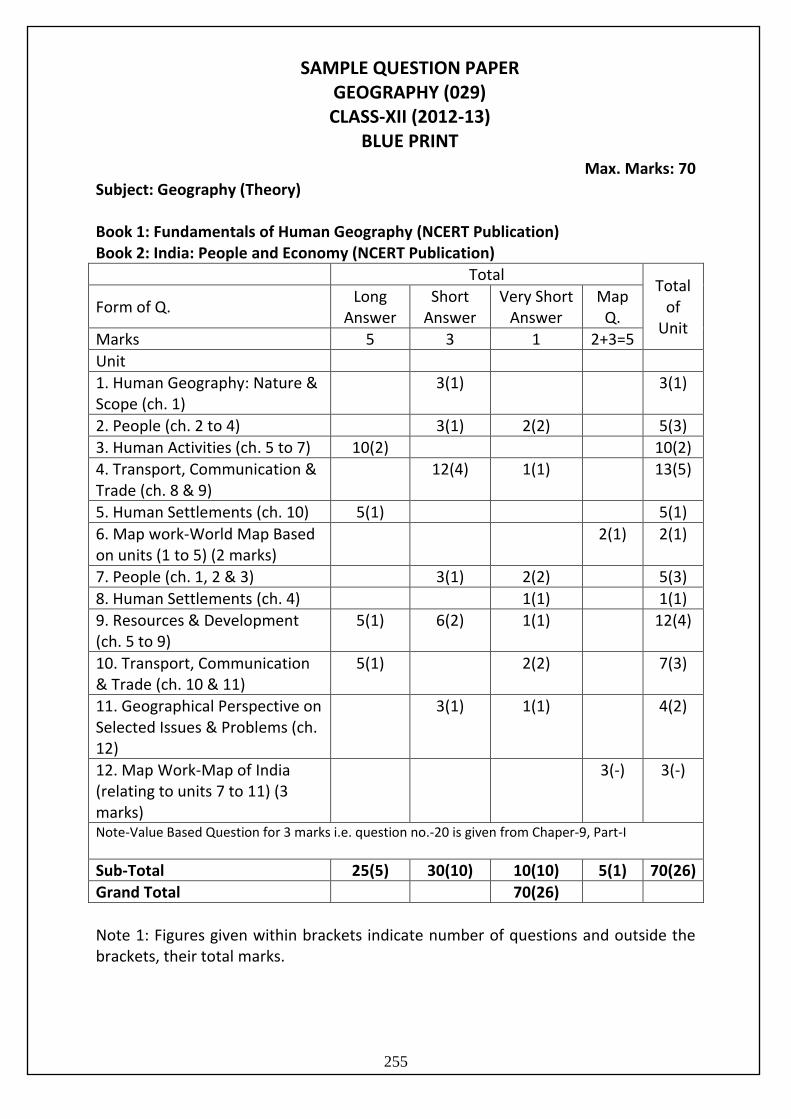
Max. Marks: 70 Subject: Geography (Theory) Book 1: Fundamentals of Human Geography (NCERT Publication) Book 2: India: People and Economy (NCERT Publication)
Total Total
of Unit
Form of Q. Long
Answer Short
Answer Very Short
Answer Map
Q.
Marks 5 3 1 2+3=5
Unit
1. Human Geography: Nature & Scope (ch. 1)
3(1) 3(1)
2. People (ch. 2 to 4) 3(1) 2(2) 5(3)
3. Human Activities (ch. 5 to 7) 10(2) 10(2)
4. Transport, Communication & Trade (ch. 8 & 9)
12(4) 1(1) 13(5)
5. Human Settlements (ch. 10) 5(1) 5(1)
6. Map work-World Map Based on units (1 to 5) (2 marks)
2(1) 2(1)
7. People (ch. 1, 2 & 3) 3(1) 2(2) 5(3)
8. Human Settlements (ch. 4) 1(1) 1(1)
9. Resources & Development (ch. 5 to 9)
5(1) 6(2) 1(1) 12(4)
10. Transport, Communication & Trade (ch. 10 & 11)
5(1) 2(2) 7(3)
11. Geographical Perspective on Selected Issues & Problems (ch. 12)
3(1) 1(1) 4(2)
12. Map Work-Map of India (relating to units 7 to 11) (3 marks)
3(-) 3(-)
Note-Value Based Question for 3 marks i.e. question no.-20 is given from Chaper-9, Part-I
Sub-Total 25(5) 30(10) 10(10) 5(1) 70(26)
Grand Total 70(26)
Note 1: Figures given within brackets indicate number of questions and outside the brackets, their total marks.
SAMPLE QUESTION PAPER GEOGRAPHY (029) CLASS-XII (2012-13)
BLUE PRINT
255
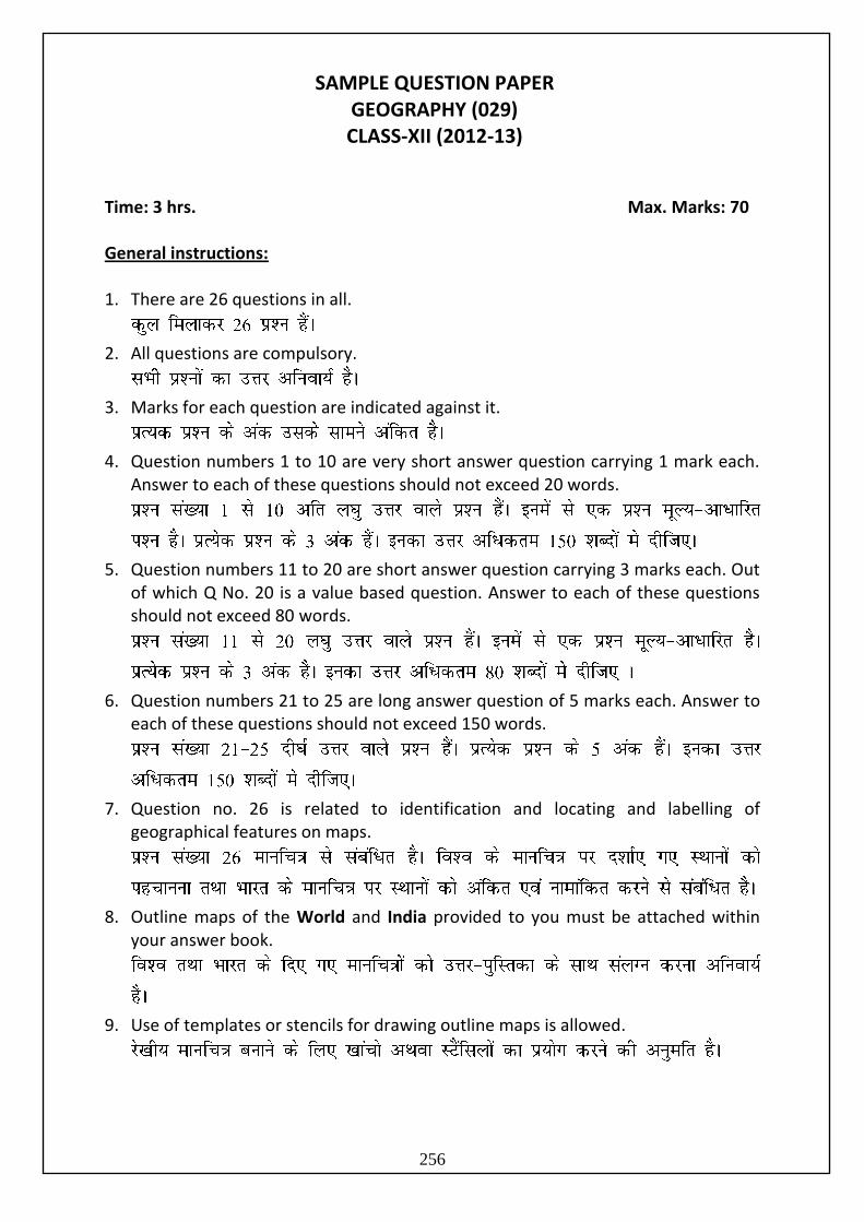
Time: 3 hrs. Max. Marks: 70 General instructions: 1. There are 26 questions in all.
2. All questions are compulsory.
3. Marks for each question are indicated against it.
4. Question numbers 1 to 10 are very short answer question carrying 1 mark each. Answer to each of these questions should not exceed 20 words.
5. Question numbers 11 to 20 are short answer question carrying 3 marks each. Out of which Q No. 20 is a value based question. Answer to each of these questions should not exceed 80 words.
6. Question numbers 21 to 25 are long answer question of 5 marks each. Answer to each of these questions should not exceed 150 words.
7. Question no. 26 is related to identification and locating and labelling of geographical features on maps.
8. Outline maps of the World and India provided to you must be attached within your answer book.
9. Use of templates or stencils for drawing outline maps is allowed.
SAMPLE QUESTION PAPER GEOGRAPHY (029) CLASS-XII (2012-13)
256
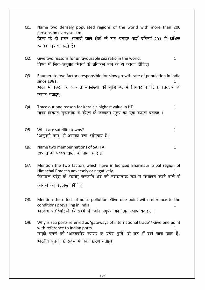
Q1. Name two densely populated regions of the world with more than 200 persons on every sq. km. 1
Q2. Give two reasons for unfavourable sex ratio in the world. 1
Q3. Enumerate two factors responsible for slow growth rate of population in India since 1981. 1
Q4. Trace out one reason for Kerala’s highest value in HDI. 1
Q5. What are satellite towns? 1
Q6. Name two member nations of SAFTA. 1
Q7. Mention the two factors which have influenced Bharmaur tribal region of
Himachal Pradesh adversely or negatively. 1
Q8. Mention the effect of noise pollution. Give one point with reference to the conditions prevailing in India. 1
Q9. Why is sea ports referred as ‘gateways of international trade’? Give one point with reference to Indian ports. 1
257
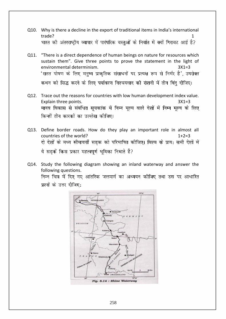
Q10. Why is there a decline in the export of traditional items in India’s international trade? 1
Q11. “There is a direct dependence of human beings on nature for resources which sustain them”. Give three points to prove the statement in the light of environmental determinism. 3X1=3
Q12. Trace out the reasons for countries with low human development index value. Explain three points. 3X1=3
Q13. Define border roads. How do they play an important role in almost all
countries of the world? 1+2=3
Q14. Study the following diagram showing an inland waterway and answer the following questions.
258
(14.1) Identify the waterway and the two countries through which it flows.
(14.2) Give one reason why this waterway is the world’s most heavily used?
2+1=3
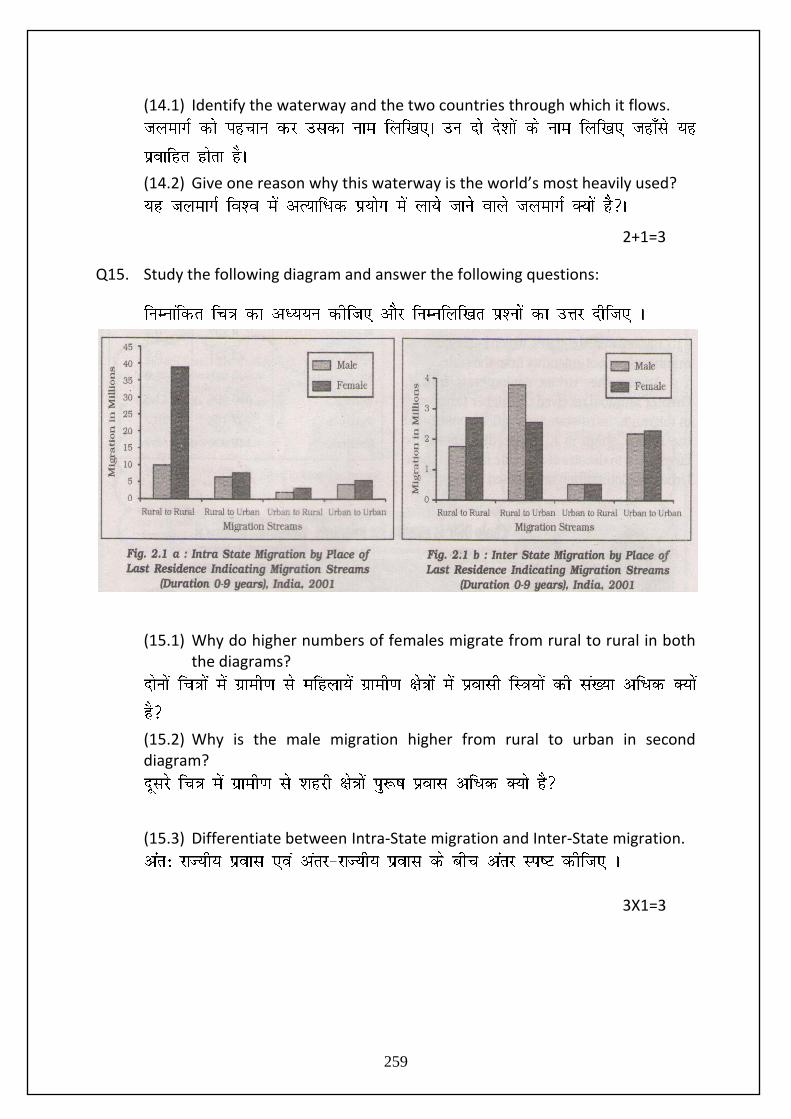
Q15. Study the following diagram and answer the following questions:
(15.1) Why do higher numbers of females migrate from rural to rural in both
the diagrams?
(15.2) Why is the male migration higher from rural to urban in second diagram?
(15.3) Differentiate between Intra-State migration and Inter-State migration.
3X1=3
259
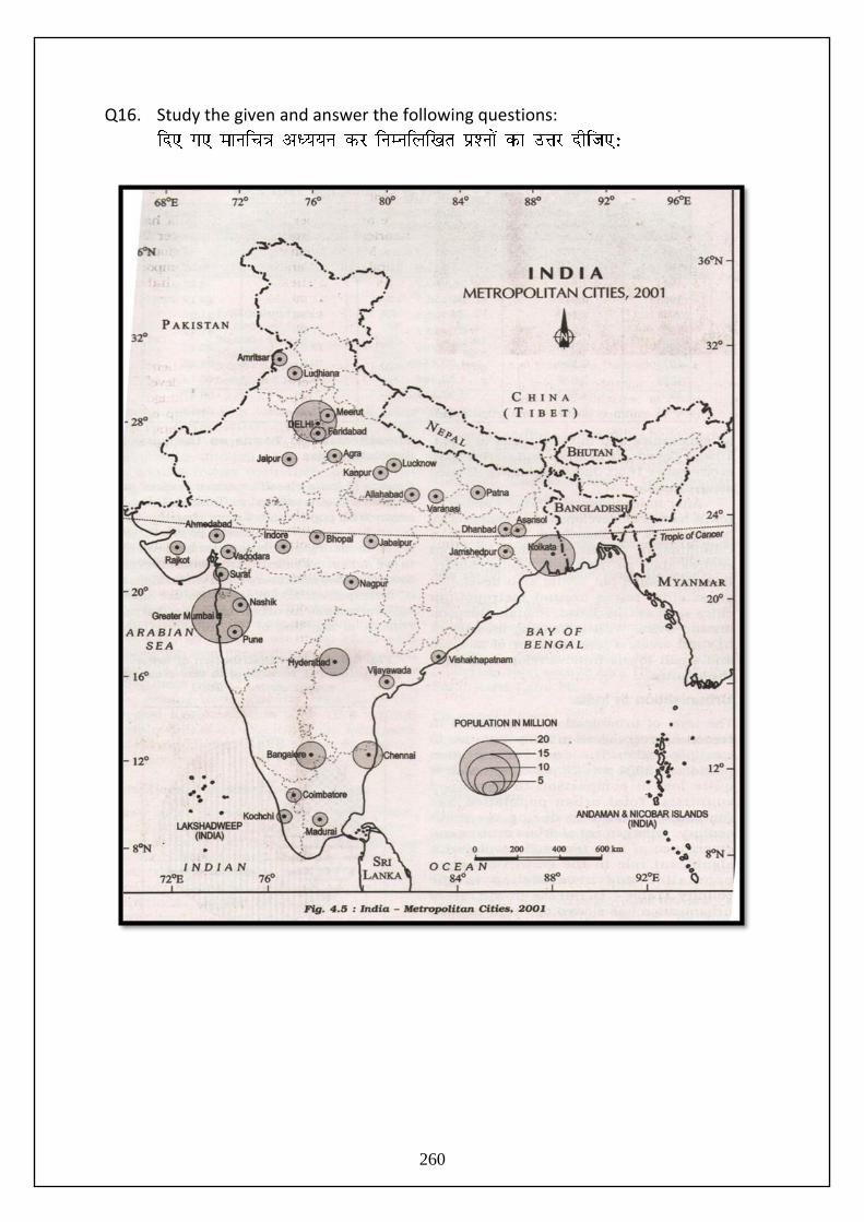
Q16. Study the given and answer the following questions:
260
(16.1) Name the largest metropolitan city and the state where it is located.
(16.2) Name two states of northern India without any metropolitan city.
(16.3) Give a reason for the absence of metropolitan city in these states.
3X1=3
Q17. Discuss any three types of ports on basis of specialized functions. 3X1=3
Q18. (18.1) Name two types of iron ore found in India fairly in abundance.
(18.2) Trace out why iron ore mines are an added advantage for the industrial development in India.
(18.3) Name two states with large reserves of Iron ore. 1+1+1=3
Q19. (19.1) Examine the contribution of sugar industry in the country’s economic
development.
(19.2) Why are most of the sugar mills located within sugar cane producing regions? 2+1=3
Q20.
Fifteenth century onwards the European colonialism began and along with trade
of exotic commodities, a new form of trade emerged which was called slave
trade. The Portuguese, Dutch, Spaniards, and British captured African natives
and forcefully transported them to the newly discovered American for their
labour in the plantations. Slave trade was a lucrative business for more than two
261
hundred years till it was abolished in Denmark in 1792, in Great Britain in 1807
and United States in 1808.
(Source: NCERT, Fundamental of Human Geography Page No. 82 )
Read the above paragraph and analyze the following:
(a) “Slavery was a curse” justify in your own words and ideas. 1½
(b) What kind of values are needed to bring slavery to an end? 1½
(1½+1½=3) Q21. Describe the salient features of ‘Dairy Farming’ in the world under the following heads:
(21.1) Meaning
(21.2) Capital
(21.3) Labour
(21.4) Market
(21.5) Main Regions 5X1=5
Q22. Classify and explain the industries on the basis of inputs/raw materials with at least one example of each. Give five points. 5X1=5
दास प्रथा के अतं हेत ुककस प्रकार के मलू्यों की आवश्यकता है?
262
Q23. Discuss rural settlement types on the basis of forms and shapes of the settlements with the help of a suitable diagram. Give five points.
5X1=5
Q24. Explain the five problems faced by Indian agriculture. 5X1=5
Q25. “Indian railways network facilitates the movement of both freight and
passengers and contributes to the growth of Indian economy.” Discuss five points to justify the statement by citing the improvements made by Indian railways. 5X1=5
Q26. (26.1) In the given outline political map of the World, four features are shown
by A, B, C, D. Identify the features with the help of the information given below and write their correct names on the lines marked in the map.
A. Country having the highest density of population in Asia.
B. Largest region of extensive commercial grain farming.
C. Eastern terminal city of Trans Siberian Railway.
D. Major airport in North America. 4X½=2
263
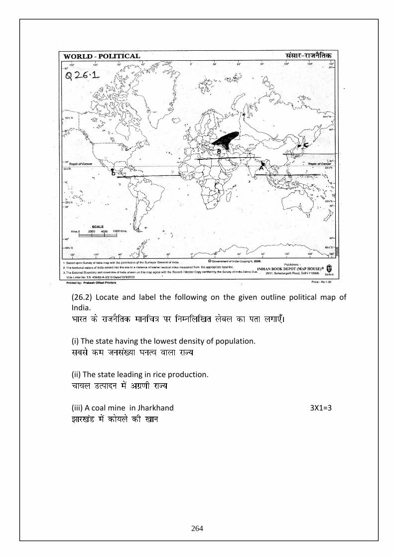
(26.2) Locate and label the following on the given outline political map of India.
(i) The state having the lowest density of population.
(ii) The state leading in rice production.
(iii) A coal mine in Jharkhand 3X1=3
264
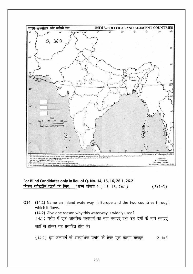
For Blind Candidates only in lieu of Q. No. 14, 15, 16, 26.1, 26.2
=
Q14. (14.1) Name an inland waterway in Europe and the two countries through
which it flows. (14.2) Give one reason why this waterway is widely used?
2+1=3
265
Q15. (15.1) Why do higher number of females migrate from rural to rural regions in India?
(15.2) Why is the male migration higher from rural to urban regions in India? (15.3) Differentiate between Intra-State migration and Inter-State migration.
3X1=3
Q16. (16.1) Name the largest metropolitan city of India and the state where it is
located. (16.2) Name two states of northern India where the level of urbanization is
low. (16.3) Give a reason why the level of urbanization is low in these states?
(1+1+1=3)
Q26. (26.1) A. Name the Country in Asia with the highest density of population. B. Name one major region of extensive commercial grain farming
in the world. C. Name the Eastern terminal city of Trans-Siberian Railway. D. Name one major airport in North America. 4X½=2
(26.2) (i) Name the state with the lowest density of population in India.
(ii) Name the state which is leading in rice production in India. (iii) Name any one coal mine in Jharkhand. 3X1=3
266
CLASS XII
SUBJECT: GEOGRAPHY
Marking Scheme
Time: 3 hrs. Max Marks: 70 Note: Page numbers of NCERT Text books (TB I for units 1 to 6 and TB II for units 7 to 12) are given after the answer of each question for its verification.
Question No.
Outline of Answer and Value Points Marks
1. Two densely populated regions of world- A) North Eastern part of USA B) North Western part of Europe C) South, South-East and East Asia
(Any two points) TB I: pg. 9
½+½=1
2. Reason for unfavourable sex ratio in the world-
Female foeticide
Female infanticide
Domestic violence against women
Lower socio-economic status of women
Any other relevant point (Any two points) TB I: pg. 17
½+½=1
3. Factors for slowing down of growth rate of population in India since 1981-
Decline in CBR(crude birth rate)
Increase in average of marriage
Improved quality of life particularly female education in India
Any other relevant point (Any two points) TB II: pg. 7
½+½=1
4. Reason for Kerala’s highest value in HDI
High literacy rate
Less gap between male and female literacy rates (or higher female literacy)
Any other relevant point (Any one point) TB II: pg. 28
1
5. Satellite towns: These are developed around metropolitan cities such as Ghaziabad, Rohtak, Gurgaon around Delhi TB II: pg. 36
1
6. Member nations of SAFTA: Bangladesh, Maldives, Bhutan, Nepal, India, Pakistan and Sri Lanka
½+½=1
267
(Any two) TB I: pg. 87
7. Negative factor for backwardness of Bharmaur tribal region of Himachal Pradesh
Harsh climatic conditions
Low resource base
Fragile environment
Geographical and political isolation
Any other relevant point (Any two factors) TB II: pg. 106-107
½+½=1
8. Effects of noise pollution:
Loss of hearing ability
Irritation and hyper tension
Any other relevant point (Any one point) TB II: pg. 138
1
9. Indian sea-ports are referred as “the gateways of India’s International trade” because-
Long coastline i.e. 7516.6 km
Smooth surface for very cheap transport
Posts are base for about 90% India’s International trade (Any one point) TB II: pg. 129
1
10. Reasons for decline in the export of traditional items in India’s international trade:-
Tough international competition
Rise in demand within the country (Explain any one point) TB I: pg. 126
1
11. Environmental Determinism- Direct dependence of human beings on nature for resources:
Low level of technology
Primitive stage of human social development
Fear of nature’s fury
Nature worship
Physical environment became ‘Mother Nature’
Complete harmony with natural environment (Explain any three points) TB I: pg 2-3
3X1=3
12. Reasons for countries with low human development index value:-
Political turmoil
Social instability in the form of civil war
Hunger, starvation and famine
A high incidence of diseases
More expenditure on defence rather than social sectors
Any other relevant point
3X1=3
268

(Explain any three points) TB I: pg 29
13. Border Roads-Roads laid along international boundaries are called border roads. Their importance-
Integrate people in remote areas with major cities
Provide defense
Used to transport goods to border villages and military camps
(Any two points) TB I: pg. 68
1+2=3
14. (14.1) Waterway-Rhine waterway The countries through which it flows-Germany, the Netherlands, Switzerland, France (Any two countries)
1+½+½=2
(14.2) Rhine waterway is world’s most heavily used waterway. Reasons-
It is navigable for 700 km. A large no. of ocean-going vessels can use it.
It flows through a rich coal i.e. Ruhr. It joins many places with a rich coal field and the whole Ruhr river basin has become a prosperous manufacturing area.
Dusseldorf is the Rhine port for this region. So, huge tonnage moves along the stretch of the Ruhr river.
This waterway connect the well developed industrial areas of Switzerland, Germany, France, Belgium and the Netherlands with the North Atlantic Sea Route.
(Any one point) TB I: pg. 76 For Blind Candidates Only Q. 14 Ans. Same as above
1
15 (15.1) Higher no. of females migrate from rural to rural areas as they move from their parental house following their marriage.
1
(15.2) Male migration is higher from rural to urban areas in case of inter-state migration as economic reasons like work and employment are the chief cause.
1
(15.3) Intra-State migration-People move from one place to another within a state eg. from Vidharbha to Mumbai in Maharashtra. Inter-State migration-People move from one state to another eg. from Patna (Bihar) to Kolkata (West Bengal). TB II: pg. 17 For Blind Candidates Only Q. 15 Ans. Same as above
½+½=1
16. (16.1) Largest Metropolitan City-Mumbai/Greater Mumbai ½+½=1
269
State-Maharashtra
(16.2) States of northern India without any metropolitan city-J&K, H.P., Uttarakhand (Any two states)
½+½=1
(16.3) Reason for absence of a metropolitan city in these states- Low level of urbanization due to lack of infrastructural facilities like transport and communication, work and employment. Moreover, hilly and mountainous region with harsh climate also add to fragile conditions. TB II: pg. 35 For Blind Candidates Only Q.16 Ans. Same as above
1
17. Types of ports on the basis of specialized functions (i) Oil ports (ii) Ports of call (iii) Packet stations (iv) Entrepot ports (v) Naval ports
(Explain any three points with one example for each) TB I: pg. 89
3X1=3
18. (18.1) Two types of iron ore found in India in abundance haematite and magnetite
½+½=1
(18.2) Occur in close proximity to the coal fields, best quality iron ore types
1
(18.3) States with large reserves of iron-ore:- Orissa, Jharkhand, Chhattisgarh, Karnataka, Goa (Any two) TB II: pg. 75
½+½=1
19. (19.1) Contribution of sugar industry in the country’s economic development:-
India is the largest producer of both sugar cane and cane sugar and contributes about 8 percent of total sugar production in the world.
This industry provides employment to lakhs of persons directly and a large no. of farmers indirectly.
Khandsari and gur (jaggery) are prepared from sugarcane. Residue (Molases) is used in making alcohols. Moreover, sugarcane beggasse is used in making paper and is used as fodder to feed cattle.
(Any two points) TB II: pg. 94
1+1=2
(19.2) Most of sugar mills are located within the cane producing regions. Reason-
Sugar cane is a weight-losing crop. Its sucrose content
1
270
begins to dry immediately after it is harvested from the field. For better recovery of sugar it should be crushed without delay.
TB II: pg. 94
20. Value hidden: (a)
1. Salve trade is a bad practice.
2. Respect human and fellow citizen equally
3. Right to equality
1½+1½=3
21. (21.1) Meaning- Dairy farming is the most advanced and efficient type of rearing of milch animals.
(21.2) Capital-It is highly capital-intensive. Animal sheds, storage facilities for fodder, feeding and milching machines add to the cost of dairy farming. Special emphasis is laid on cattle breeding, health care and veterinary services which requires huge amount of capital.
(21.3) Labour-It is highly labour-intensive as it involves rigorous care in feeding and milching. There is no off-season during the year unlike crop-raising so a large no. skilled and semi-skilled labourers gets ample employment opportunities in dairy farming.
(21.4) Market-Dairy farming is mainly practiced near urban and industrial centers which provide neighbourhood market for fresh milk and dairy products.
(21.5) Main Regions-three main regions in the world A) The largest is North-Western Europe B) Canada & North-Eastern USA C) South-Eastern Australia, New Zealand and Tasmania TB I: pg. 38-39
5X1=5
22. Classification of industries on the basis of inputs/raw materials-
Agro-based Industries eg. Food processing, sugar industry, pickle and fruit juices, beverages i.e. tea, coffee and cocoa (any one example)
Mineral-based Industries eg. Iron and steel industries, aluminium smelting, copper smelting, jewellary industry, cement industry (any one example)
Chemical-based industries eg. Petro-chemicals, salts, sulphur , potash synthetic fiber, plastic (any one example)
Forest-based industry eg. Furniture, paper, rubber industry (any one example)
Animal-based industry eg. Leather, woollen textile,
5X1=5
(b) Respect for human life. Dignity of labour.
Holding one's self esteem and working hard to protect it.
271
ivory (any one example) (Explain five types and give one example for each) TB I: pg. 50-51
23. Rural Settlement types on the basis of forms and shapes a) Linear pattern b) Rectangular pattern c) Circular pattern d) Star-like pattern e) T-shaped, Y-shaped or Cross-shaped pattern f) Double village pattern(Insert Fig. 10.5 Pg 94 TB I)
(Explain any five points and draw their diagrams) TB I: pg. 93-94
5X1=5
24. Problems faced by Indian agriculture
Dependence on Erratic Monsoon
Low productivity
Constraints of financial resources and indebtedness
Lack of land reforms
Small farm size and fragmentation of land-holdings
Lack of commercialization
Vast under-employment
Degradation of cultivable land (Explain any five points) TB II: pg. 56-58
5X1=5
25. Improvements made by India Railways:-
Conversion of metre and narrow gauges into broad gauges.
Replacing steam engines by diesel and electric engines
Increase in speed and haulage capacity
Introduction of Metro rail
Extension of rail routes to remote and marginalized areas
Development of Konkan Railway along the western coast, an area where land-slides are very common.
Computerized railway reservation system
Better facilities at railway stations and within the trains (Explain any five points) TB II: pg. 118-119
5X1=5
26. (26.1) To be written on the given world map in the space provide
272

A. Bangladesh B. Eurasian Steppes C. Vladivostok D. Mexico City For Blind Candidates Only Q. 26.1 Ans. A. Bangladesh B. Eurasian Steppes/American Prairies/ Pampas of Argentina/Velds of South Africa/Australian Downs/ Canterbury of New Zealand C. Vladivostok D. Mexico City/ Chicago/New York/Vancouver/Boston/Toronto
(26.2) To be located and labeled in the given map of India
273
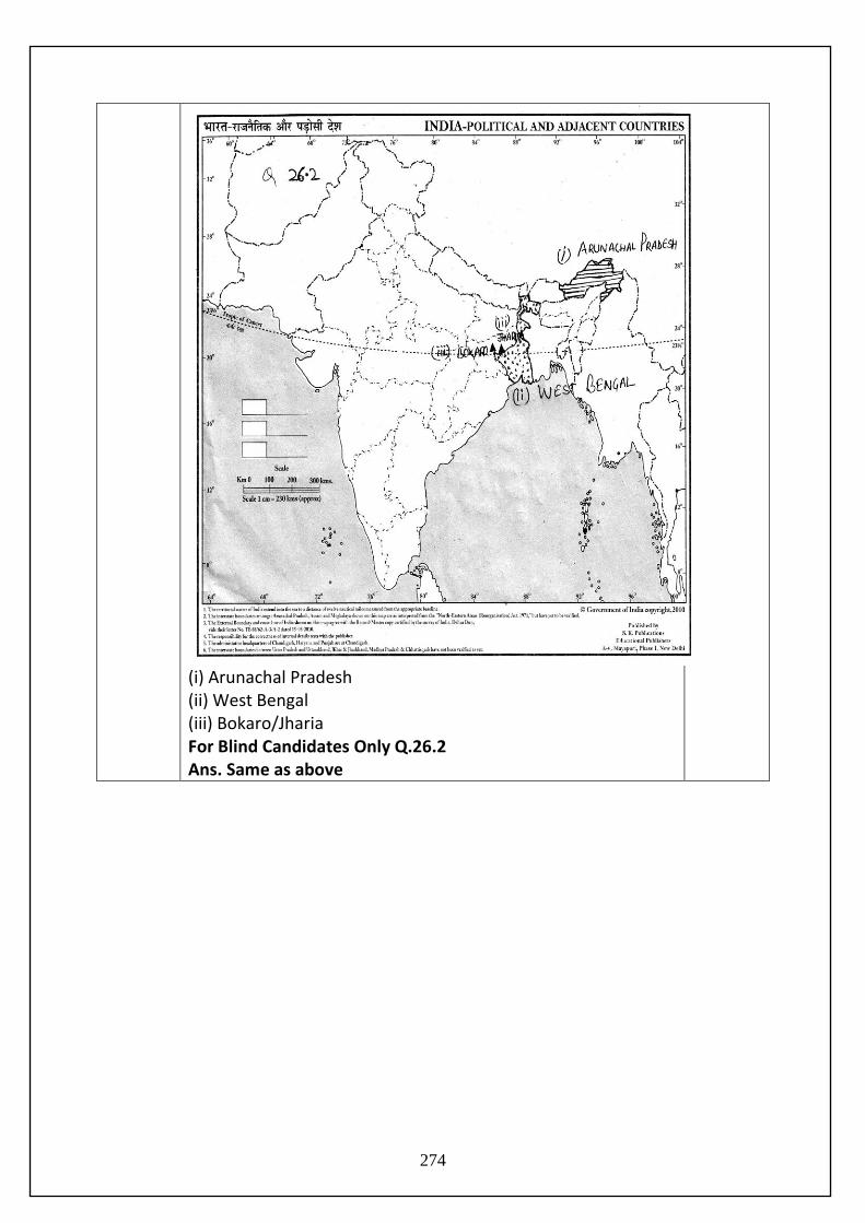
(i) Arunachal Pradesh (ii) West Bengal (iii) Bokaro/Jharia For Blind Candidates Only Q.26.2 Ans. Same as above
274


![FUNDAMENTALS OF HUMAN GEOGRAPHY - …]_Fundamentals_Of_Human...FUNDAMENTALS OF HUMAN GEOGRAPHY Textbook for Class XII Authors Hira Lal Yadav ... geography, which overemphasised physical](https://img.pdfslide.net/doc/110x75/5adb6b4e7f8b9aee348dfed8/fundamentals-of-human-geography-fundamentalsofhumanfundamentals-of.jpg)