Embed Size (px)
Citation preview
dr. F. WENDLAND, dr. F. HERRMANN, dr. R. KUNKEL, dr. B. TETZLAFF
- 118 - SUŠA PONOVNO V LETU 2013
24. MIŠIČEV VODARSKI DAN 2013
dr. Frank WENDLAND * dr. Frank HERRMANN dr. Ralf KUNKEL dr. Björn TETZLAFF
SYSTEM OF GROWA MODELS -HISTORY AND APPLICATION IN GERMANY AND ABROAD-
ABSTRACT
GROWA has grown from the first model, addressing main runoff components in mid-90s, into a system of models that is still being developed for various water management applications. So far it has enabled analyses of water balance and nutrient flow. Nowadays, development is focused on higher time resolution and additional features (e.g. for irrigation management), and regional water balances including climate change impacts for large areas. Application of GROWA has already spread to a number of German Federal States as well as to several EU members and Turkey. In Slovenia GROWA proved to be useful tool for water balance of the whole territory, while the know-how transfer for nutrient flow modelling is now in final phase. There are open possibilities for future German-Slovenian cooperation, especially in the field of current model development.
HISTORY AND DEVELOPMENT OF GROWA MODEL
GROWA development started in the mid-90s in order to determine the main runoff components (direct runoff and groundwater runoff) as a function of the interaction between the actual land cover and climatic, pedologic, topographic, and hydrogeological conditions. In the subsequent years GROWA was further developed and applied in the framework of national and international research projects:
- Developed 1996-1998 in the framework of the BMBF research priority „Elbe-Ecology“
- 1999-2006: Cooperation with Lower Saxony's Federal Agency for Mining, Energy and Geology (LBEG) and the Federal Environment Agency of the Federal State of North Rhine - Westphalia (LANUV); implementation of the model in the Environment information systems NIBIS and HYGRIS; use of GROWA results for quantitative status review according to EU-WFD
- 2002 – 2004: Further development for urban areas and application for Metropolitan area Hamburg in cooperation with Umweltbehörde Hamburg (BSU)
- 2006-2008: further development of GROWA for lignite area Lower Rhine embayment (upper boundary condition for groundwater model) in cooperation with RWE – Power
- Since 2006: Application and further development in a number of international projects and cooperation:
o the EU – LIFE – Project WAgriCo, o in Turkish catchment areas (Izmit bay, Porsuk river…) o in Greek catchments (Thessaly) o in Slovenia
- Since 2008: Further development in the framework of studies on behalf of several Federal Environment ministries and agencies. GROWA is used for the determination and management of nutrient inputs (N and P) into groundwater and surface water on the Federal State level, including applications in:
o Saarland (water balance) o Weser basin (nutrient modelling) o Hessen (modelling of erosion )
* dr. Frank WENDLAND, dr. Frank HERRMANN, dr. Ralf KUNKEL, dr. Björn TETZLAFF, Forschungszentrum Jülich GmbH, Agrosphere Institute (IBG-3), D-52425 Jülich, Germany

dr. F. WENDLAND, dr. F. HERRMANN, dr. R. KUNKEL, dr. B. TETZLAFF
- 119 - SUŠA PONOVNO V LETU 2013
24. MIŠIČEV VODARSKI DAN 2013
o Sachsen-Anhalt (nutrient modelling) o Schleswig-Holstein (nutrient modelling) o Mecklenburg-Vorpommern (nutrient modelling) o Thüringen (nutrient modelling)
- Since 2009: Further development of GROWA for impact analyses of climate change on water resources. Increasing temporal resolution and development of mGROWA model in the framework of:
o the EU project CLIMB (Sardinia, France and Turkey) o the BMBF research Priority KLIMZUG in Metropolitan area Hamburg (Germany) o on behalf of the Environment ministries of Lower Saxony and Northrhine-Westfalia.
THE GROWA MODEL AT A GLANCE: INPUT, PROCEDURE AND OUTPUT Growa is a grid based model consisting of several modules, enabling separation of input precipitation into main water balance components: real evapotranspiration, total discharge, direct runoff and groundwater recharge (Fig. 1). Modular concept of the model makes it possible to adapt individual modules in the case of discordance between modelled and measured values.
Figure 1: The GROWA model at a glance: Input, procedure and output. Main features of the model are as follows:
- Scale of application: 100 - 500.000 km² - Spatial resolution: Variable, grids - Temporal resolution: Year - Input data: Digital data (e. g. maps…) - Potential evapotranspiration: Penman – Monteith equation - Runoff separation: base flow indices (BFI)

dr. F. WENDLAND, dr. F. HERRMANN, dr. R. KUNKEL, dr. B. TETZLAFF
- 120 - SUŠA PONOVNO V LETU 2013
24. MIŠIČEV VODARSKI DAN 2013
- Results: Total runoff, percolation water, direct runoff (overland flow, interflow, drainage flow), groundwater recharge
- Validation: observed runoff at gauging stations (MQ, MoMNQ) - Implementation: C++; GIS- linkages to GRASS / ArcView
GROWA MODEL APPLICATIONS IN GERMANY I: QUANTITATIVE STATUS ASSESSMENT In Germany the GROWA model was applied to regions ranging typically between mesoscale river basins of approximately 1000 km2 up to entire States or river catchments of 100,000 km2 and more (Kunkel et al., 2006). In the regions where it has been applied the GROWA model results are used for practical water resources management related issues, e.g. the granting of permits to abstract groundwater on a regional level and for the status reviews of the groundwater bodies according to the EU Water Framework Directive. For the federal states North Rhine Westphalia, Lower Saxony, Hamburg as well as Bremen the mean long-term area distributed water balance was calculated, in collaboration with the Geological Surveys of the above mentioned Federal German States (Figure 2). As each Federal State has a different data basis the challenge was to unify this data to one homogeneously data set which should be used to model the water balance: real evapotranspiration, total runoff, direct runoff, groundwater recharge.
Figure 2: Mean long-term groundwater recharge in North-West Germany.
GROWA MODEL APPLICATIONS IN GERNMANY II: NUTRIENT MANAGEMEN The discharge of plant nutrients from the soil into the groundwater and surface water is always bound to the runoff components. For this purpose GROWA model has been coupled to the reactive N-transport models GROWA-DENUZ/WEKU (Kunkel & Wendland, 2006; 1997) and the P-transport
dr. F. WEdr. R. KU
24. MIŠI
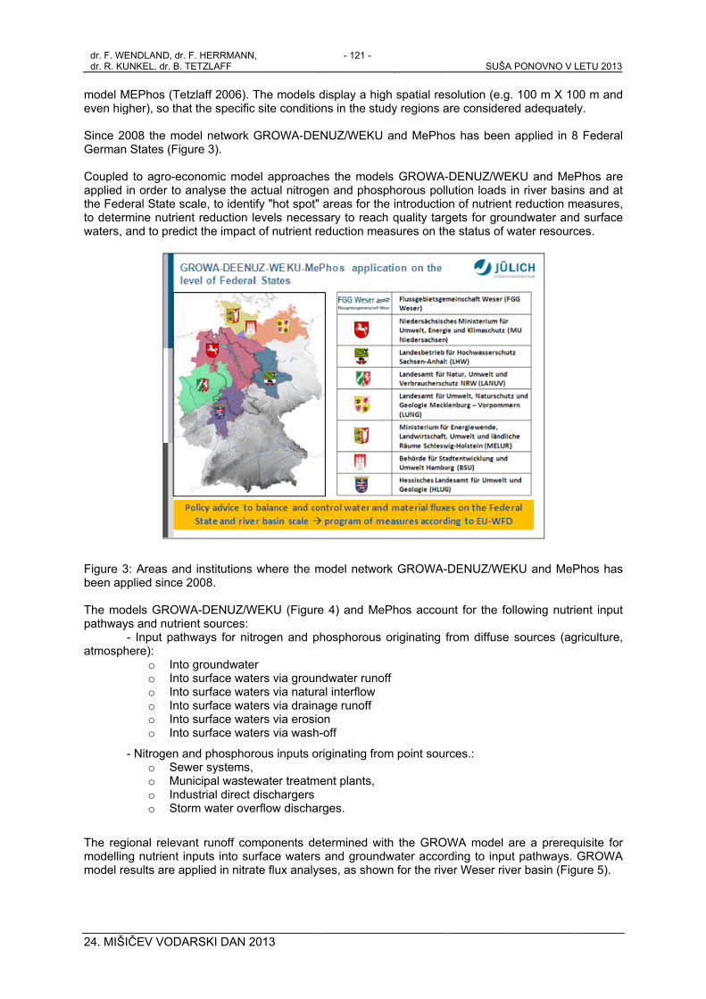
model Meven hig Since 20German Coupledapplied ithe Fedeto determwaters, a
Figure 3been ap The modpathway
-atmosph
-
The regimodellinmodel re
ENDLAND, dr. FUNKEL, dr. B. TE
ČEV VODAR
MEPhos (Tetzgher), so that
008 the modStates (Figu
to agro-ecoin order to aeral State scamine nutrienand to predic
3: Areas andplied since 2
dels GROWAys and nutrien- Input pathw
here): o Into o Into o Into o Into o Into o Into
- Nitrogen ano Sewo Muno Induo Stor
ional relevang nutrient in
esults are ap
F. HERRMANN,ETZLAFF
RSKI DAN 2
zlaff 2006). Tt the specific
del network Gure 3).
onomic modenalyse the aale, to identit reduction lect the impact
institutions 2008.
A-DENUZ/Wnt sources: ways for nitr
groundwatesurface watesurface watesurface watesurface watesurface wate
nd phosphorower systems, nicipal wastewustrial direct dm water ove
nt runoff computs into suplied in nitra
,
013
The models site conditio
GROWA-DE
el approacheactual nitrogefy "hot spot"evels necesst of nutrient r
where the m
WEKU (Figure
rogen and p
r ers via grouners via naturaers via drainaers via erosioers via wash
ous inputs o
water treatmdischargers
erflow discha
mponents derface waterste flux analy
- 121 -
display a higons in the stu
ENUZ/WEKU
es the modeen and phos areas for thsary to reacheduction me
model netwo
e 4) and Me
hosphorous
ndwater runoal interflow age runoff on -off
riginating fro
ent plants,
rges.
etermined wis and groundses, as show
gh spatial resudy regions a
and MePho
els GROWA-phorous polle introductioh quality targ
easures on th
rk GROWA-
ePhos accou
originating f
off
om point sour
ith the GROdwater accorwn for the riv
SUŠA
solution (e.gare considere
os has been
-DENUZ/WElution loads
on of nutrientgets for grouhe status of w
-DENUZ/WE
unt for the fo
from diffuse
rces.:
WA model arding to inpuer Weser riv
A PONOVNO V
. 100 m X 10ed adequate
applied in 8
EKU and Mein river basint reduction mundwater andwater resourc
KU and MeP
ollowing nutri
sources (ag
are a prerequt pathways. ver basin (Fig
LETU 2013
00 m and ly.
8 Federal
Phos are ns and at
measures, d surface ces.
Phos has
ient input
griculture,
quisite for GROWA
gure 5).

dr. F. WENdr. R. KUN
24. MIŠI
Figure 4
Figure 5 GROWAs GRObalance,
NDLAND, dr. F. NKEL, dr. B. TET
ČEV VODAR
: Flow diagra
: Representa
WA MODELOWA model h
, including g
HERRMANN, TZLAFF
RSKI DAN 2
am showing
ative results
L APPLICAhad been devroundwater r
013
the role of G
for nutrient f
ATIONS Oveloped, calirecharge in
- 122 -
GROWA in ni
flux modelling
OUTSIDE Gbrated and vGermany, a
trate flux ana
g in the Wes
GERMANYvalidated initin area-cover
SUŠA P
alyses.
ser basin, Ge
Y ally for the dring applicab
PONOVNO V LE
ermany.
determinationbility in regio
ETU 2013
n of water ons out of
dr. F. WEdr. R. KU
24. MIŠI
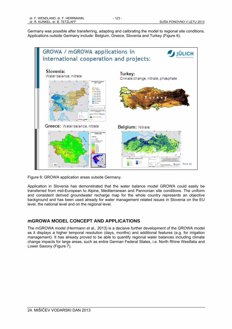
GermanyApplicati
Figure 6 Applicatitransferrand conbackgroulevel, the
mGROThe mGas it dismanagechange iLower S
ENDLAND, dr. FUNKEL, dr. B. TE
ČEV VODAR
y was possibions outside
: GROWA ap
ion in Slovered from midnsistent derivund and hase national lev
OWA MODEROWA modeplays a highment). It hasimpacts for laxony (Figur
F. HERRMANN,ETZLAFF
RSKI DAN 2
ble after transGermany inc
pplication are
enia has demd-European tved groundws been used vel and on th
EL CONCEel (Herrmannher temporals already proarge areas, re 7).
,
013
sferring, adaclude: Belgiu
eas outside G
monstrated tto Alpine, Mewater rechar
already for he regional le
EPT AND n et al., 2013 resolution (oved to be asuch as enti
- 123 -
apting and caum, Greece,
Germany.
that the watediterraneanrge map forwater mana
evel.
APPLICA3) is a decisiv(days, monthable to quantre German F
alibrating theSlovenia and
ter balance n and Pannor the whole gement relat
TIONS ve further dehs) and addtify regional Federal State
SUŠA
model to regd Turkey (Fig
model GROonian site co
country repted issues in
evelopment oitional featurwater balan
es, i.e. North
A PONOVNO V
gional site cogure 6).
OWA could enditions. The
presents an n Slovenia o
of the GROWres (e.g. for ces includin
h Rhine Wes
LETU 2013
onditions.
easily be e uniform objective
on the EU
WA model irrigation g climate tfalia and

dr. F. WENdr. R. KUN
24. MIŠI
Figure 7Germany Another irrigationarid MedFrance,
Figure 8
NDLAND, dr. F. NKEL, dr. B. TET
ČEV VODAR
7: Possible imy.
field of appln managemediterranean the Kocaeli p
: Simulation
HERRMANN, TZLAFF
RSKI DAN 2
mpact of clim
lication of thent in agricult
regions in tprovince in T
of soil moist
013
mate change
e mGROWAture (Figure 8the framewoTurkey (Figur
ture deficit an
- 124 -
e on groundw
A model is th8). At presen
ork of the Ere 9), and the
nd irrigation
water rechar
he simulationnt the mGROU CLIMB pe Mannu Rui
needs in Low
SUŠA P
ge 1981- 21
n of soil moiOWA model iroject to thei catchment a
wer Saxony,
PONOVNO V LE
00 in Lower
sture deficitss transferred
e Thau catcat Sardinia.
Germany.
ETU 2013
r Saxony,
s and the d to semi-chment in
dr. F. WEdr. R. KU
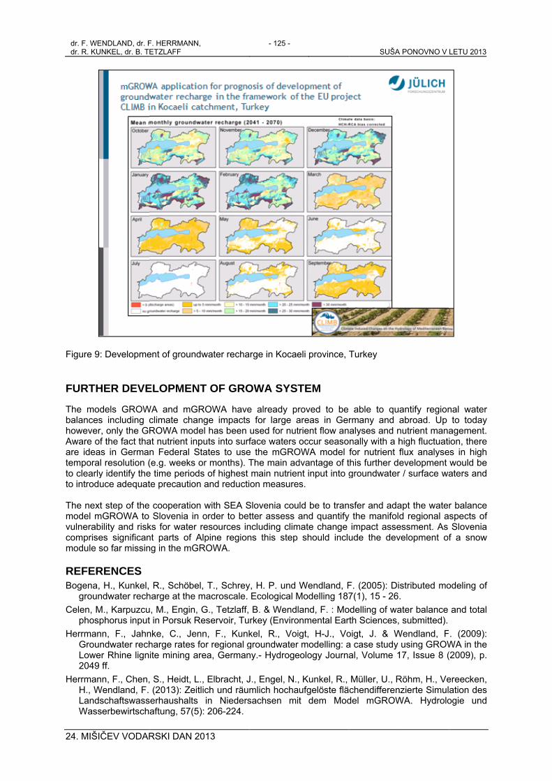
24. MIŠI
Figure 9
FURTH
The mobalanceshoweverAware oare ideatemporato clearlyto introdu The nexmodel mvulnerabcomprisemodule s
REFERBogena,
grounCelen, M
phospHerrman
GrouLowe2049
HerrmanH., WLandsWass
ENDLAND, dr. FUNKEL, dr. B. TE
ČEV VODAR
: Developme
HER DEVE
dels GROWs including cr, only the GRf the fact tha
as in Germanl resolution (y identify theuce adequat
t step of the mGROWA to bility and riskes significanso far missin
RENCES H., Kunkel,
ndwater rechM., Karpuzcuphorus inputnn, F., Jahnndwater rech
er Rhine lignff.
nn, F., Chen,Wendland, F.
schaftswassserbewirtsch
F. HERRMANN,ETZLAFF
RSKI DAN 2
ent of ground
ELOPMEN
WA and mGRclimate chanROWA modeat nutrient inpn Federal S(e.g. weeks oe time periodte precaution
cooperationSlovenia in
ks for water nt parts of Ang in the mGR
R., Schöbeharge at the mu, M., Engin, t in Porsuk Rnke, C., Jenharge rates fite mining ar
S., Heidt, L(2013): Zeiterhaushalts aftung, 57(5
,
013
dwater recha
T OF GRO
ROWA havenge impactsel has been puts into surftates to useor months). Ts of highest
n and reducti
n with SEA Sorder to betresources in
Alpine regionROWA.
l, T., Schreymacroscale. G., Tetzlaff,
Reservoir, Tunn, F., Kunkfor regional grea, German
., Elbracht, Jtlich und räum
in Nieders): 206-224.
- 125 -
rge in Kocae
OWA SYST
e already prs for large aused for nutface waters o
e the mGROThe main admain nutrienon measures
Slovenia coutter assess a
ncluding climns this step
y, H. P. und WEcological MB. & Wendlrkey (Envirokel, R., Voiggroundwater ny.- Hydroge
J., Engel, N.,mlich hochausachsen mit
eli province, T
TEM
roved to be areas in Gerrient flow anoccur seaso
OWA model fdvantage of tnt input into gs.
ld be to tranand quantify
mate change should inclu
Wendland, FModelling 187and, F. : Monmental Eartgt, H-J., Vomodelling: a
eology Journa
Kunkel, R., ufgelöste flät dem Mod
SUŠA
Turkey
able to qurmany and alyses and nnally with a hfor nutrient fthis further dgroundwater
sfer and ada the manifolimpact asse
ude the dev
F. (2005): Di7(1), 15 - 26
odelling of wath Sciences,
oigt, J. & Wa case study al, Volume 1
Müller, U., Rchendifferendel mGROW
A PONOVNO V
antify regionabroad. Up nutrient manahigh fluctuatiflux analyseevelopment r / surface wa
apt the waterd regional a
essment. As velopment of
stributed mo. ater balance submitted).
Wendland, Fusing GROW
17, Issue 8 (
Röhm, H., Venzierte SimulWA. Hydrolo
LETU 2013
nal water to today
agement. ion, there
es in high would be aters and
r balance spects of Slovenia
f a snow
odeling of
and total
. (2009): WA in the (2009), p.
ereecken, ation des ogie und
dr. F. WENDLAND, dr. F. HERRMANN, dr. R. KUNKEL, dr. B. TETZLAFF
- 126 - SUŠA PONOVNO V LETU 2013
24. MIŠIČEV VODARSKI DAN 2013
Kuhr, P., Haider, J., Kreins, P., Kunkel, R., Tetzlaff, B., Vereecken, H., & Wendland, F. (2013): Model Based Assessment of Nitrate Pollution of Water Resources on a Federal State Level for the Dimensioning of Agro-environmental Reduction Strategies: The North Rhine-Westphalia (Germany) Case Study. - Water Resources Management, 27(3), 885-909.
Kunkel, R. und Wendland, F. (2002): The GROWA98 model for water balance analysis in large river basins; the River Elbe case study. Journal of Hydrology 259(1-4), 152 - 162.
Kunkel, R., Bogena, H., Tetzlaff, B. und Wendland, F. (2006): Digitale Grundwasserneubildungskarte von Niedersachsen, Nordrhein-Westfalen, Hamburg und Bremen: Erstellung und Auswertungsbeispiele. Hydrologie und Wasserbewirtschaftung 50, H5, 212 – 220.
Kunkel, R., M. Eisele & F. Wendland (2008): Assessing necessary nutrient reduction for measurement planning in groundwater bodies. Water Science and Technology, 58 (12), 2295-2302.
Kunkel, R., M. Eisele, W. Schäfer, B. Tetzlaff & F. Wendland (2008): Planning and implementation of nitrogen reduction measures in catchment areas based on a determination and ranking of target areas. Desalination, 226, 1-12.
Kunkel, R.,Kreins, P., Tetzlaff, B.,& Wendland, F. (2010): Forecasting the effects of EU policy measures on the nitrate pollution of groundwater and surface waters, Journal of Environmental Sciences, 22 (6),872-877
Montzka, C., M. Canty, R. Kunkel, G. Menz, H. Vereecken and F. Wendland (2008): Modelling the water balance of a mesoscale catchment basin using remotely sensed land cover data. Journal of Hydrology 353, 322 - 334 .
Montzka, C., M. Canty, P. Kreins, R. Kunkel, G. Menz, H. Vereecken & F. Wendland (2008): Multispectral remotely sensed data in modelling the annual variability of nitrate concentrations in the leachate. Environmental Modelling & Software, 23 (8), 1070-1081.
Panagopoulos, A., Arampatzis, G., Kuhr, P., Kunkel, R., Tziritis, E. & Wendland, F.: Area-differentiated modeling of water balance in Pinios Basin, central Greece (Water Resources Management, submitted)
Tetzlaff, B., Kuhr, P., Vereecken, H. u. Wendland, F. (2009): Aerial photograph-based delineation of artificially drained areas and their relevance for water balance and nutrient modeling in large river basins.- Physics and Chemistry of the Earth 34, 552 – 564.
Tetzlaff, B., Friedrich, K., Vorderbrügge, T., Vereecken, H. & Wendland, F. (2011): Distributed modelling of mean annual soil erosion and sediment delivery rates to surface waters, Catena, 102, 13-20.
Tetzlaff, B., Andjelov, M., Uhan, J & Wendland, F.: Distributed modelling of groundwater recharge in Slovenia (Environmental Earth Sciences, accepted)
Tetzlaff, B., Kuhr, P., Vereecken, H. u. Wendland, F. (2009): Aerial photograph-based delineation of artificially drained areas and their relevance for water balance and nutrient modeling in large river basins.- Physics and Chemistry of the Earth 34, 552 – 564..
Tetzlaff, B., H. Vereecken, R. Kunkel & F. Wendland (2009): Modelling phosphorus inputs from agricultural sources and urban areas in river basins. Environmental Geology, 57, 183-193.
Tetzlaff,B.; Hake,J.-F.; Vereecken,H.; Wendland,F. (2010): Sustainable use of water resources in Europe and the role of integrated modelling of phosphate fluxes International Journal of Global Environmental Issues (IJGENVI), 10 (2010) 1/2, 172 – 193
Tetzlaff, B. & Wendland, F. (2012): Modelling sediment input to surface waters for German states with MEPhos: Methodology, sensitivity and uncertainty, Water Resources Management, 165-184.
Wendland, F., Kunkel, R., Tetzlaff, B. und Doerhoefer, G. (2003): GIS-based determination of the mean long-term groundwater recharge in Lower Saxony. Environmental Geology 45(2), 273 - 278.
Wendland, F., H. Behrendt, H. Gömann, U. Hirt, P. Kreins, U. Kuhn, R. Kunkel & B. Tetzlaff (2009): Determination of nitrogen reduction levels necessary to reach groundwater quality targets in large river basins: the Weser basin case study, Germany. Nutrient Cycling in Agroecosystems, 85 (1), 63-78.
Wendland F., Horst Behrendt, Ulrike Hirt, Peter Kreins, Ute Kuhn, Petra Kuhr, Ralf Kunkel und Björn Tetzlaff (2010): Analyse von Agrar- und Umweltmaßnahmen zur Reduktion der Stickstoffbelastung von Grundwasser und Oberflächengewässer in der Flussgebietseinheit Weser. Hydrologie und Wasserbewirtschaftung, 54. Jahrgang, Heft 4, August 2010, 231 – 244.