Embed Size (px)
Citation preview

THE DNR INSPECTOR.
REINFORCED CONCRETE PIPES AND INCIDENTAL WORK AS REQUIRED BY
PAVEMENT AND THE INSTALLATION OF DOUBLE 30" EQUIVALENT ARCH
EXISTING 12" METAL PIPES, PCC LOW WATER CROSSING, EXISTING HMA
THE CULVERT REPLACEMENT PROJECT INCLUDES THE REMOVAL OF FOUR
ALL
17
G.02
G.01
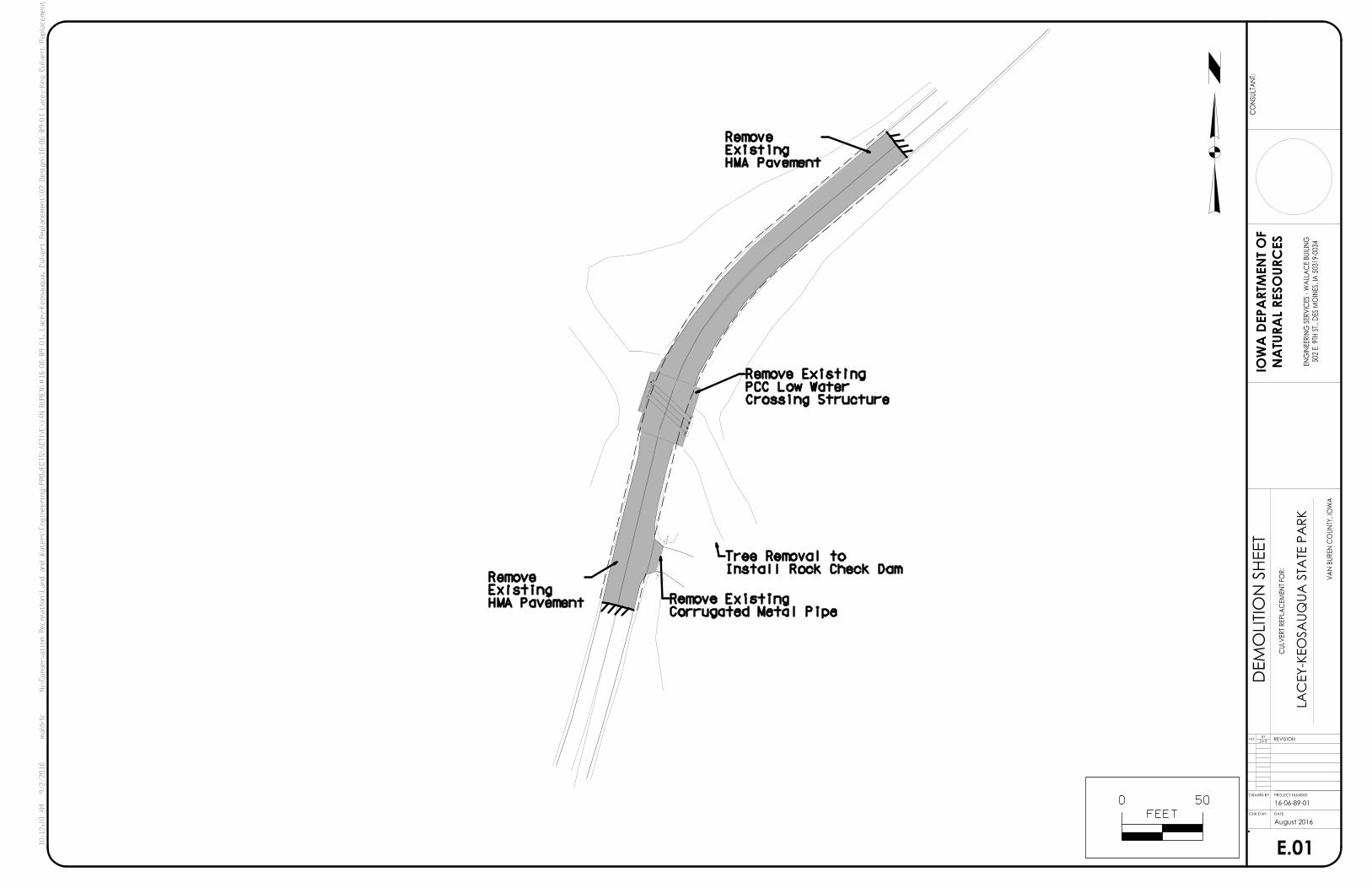
E.01
D.03
D.02
D.01
C.02
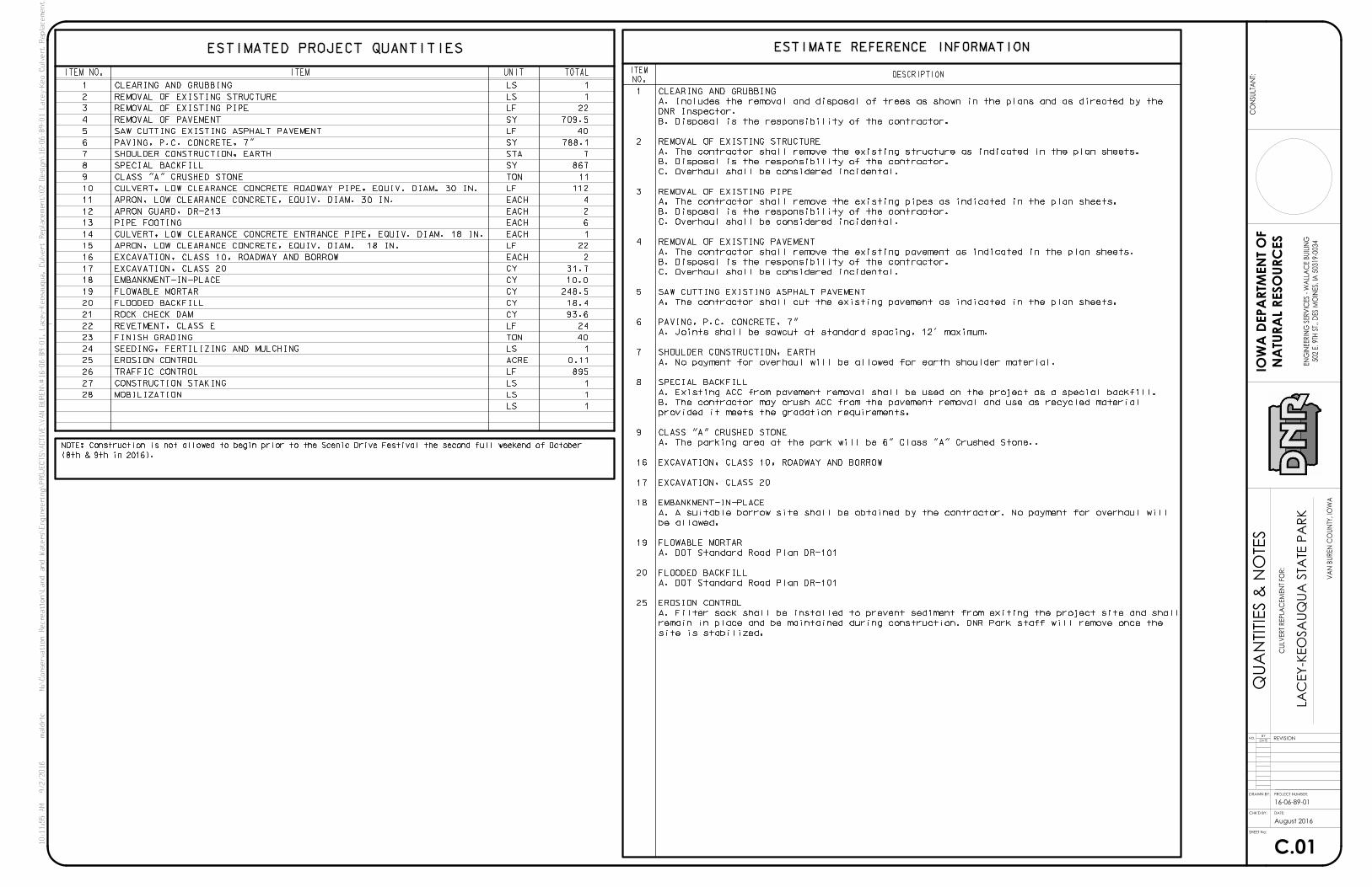
C.01
B.04
B.03
B.02
B.01
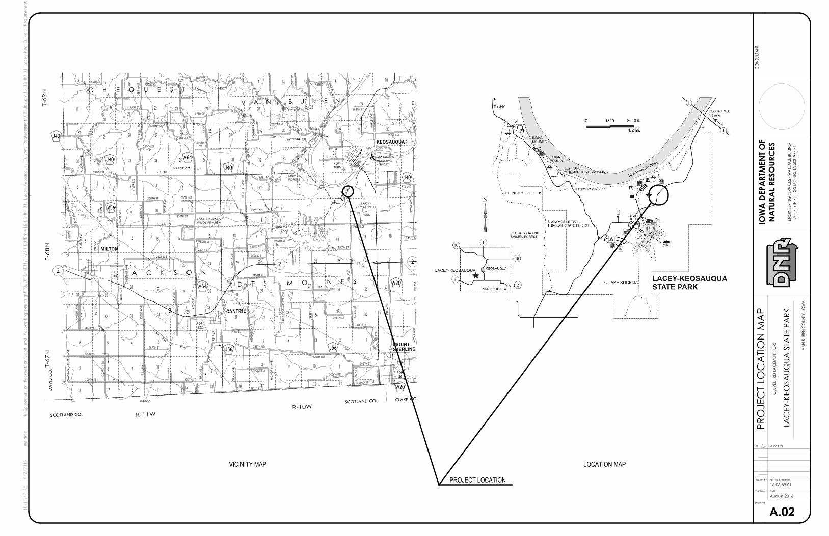
A.02
A.01
SURVEY CONTROL
SURVEY CONTROL
DEMOLITION SHEET
PROFILE SHEET
PROFILE SHEET
PLAN SHEET
GENERAL NOTES
QUANTITIES & NOTES
GENERAL DETAILS
GENERAL DETAILS
GENERAL DETAILS
GENERAL DETAILS
PROJECT LOCATION MAPS
COVER SHEET
LACEY-KEOSAUQUA STATE PARK
LA
CE
Y-K
EO
SA
UQ
UA S
TA
TE P
AR
K
CULVERT REPLACEMENT
CU
LV
ER
T R
EP
LA
CE
ME
NT F
OR:
16-06-89-01
PROJECT # 16-06-89-01
VAN BUREN COUNTY
VA
N B
UR
EN C
OU
NTY, IO
WA
August 2016
PROJECT DESCRIPTION AUTHORIZATION TO BID
DATEENGINEERING BUREAU CHIEF
DATEAUTHORIZATION - PARKS | WILDLIFE | FISHERIES | LAW ENFORCEMENT | FORESTRYPROJECT NUMBER:
DATE:
NO.DATE
BYREVISION
DRAWN BY:
CHK’D BY:
SHEET No:
NA
TU
RA
L R
ES
OU
RC
ES
IOW
A D
EP
ART
ME
NT O
F
502 E. 9TH S
T., D
ES M
OIN
ES, IA 5
0319-0
034
EN
GIN
EERIN
G S
ER
VIC
ES - W
ALLA
CE B
UILIN
G
DIRECTORY
COMPANY
ADDRESS
CITY,STATE,ZIP
TELEPHONE
FAX
CONTACT
COMPANY
ADDRESS
CITY,STATE,ZIP
TELEPHONE
FAX
CONTACT
PROJECT MANAGER CONSTRUCTION INSPECTOR
CO
NS
ULTA
NT:
I hereby certify that this engineering document was prepared
by me or under my direct personal supervision and that I am
a duly licensed Professional Engineer under the laws of the
Date
My license renewal date is December 31, 20
Pages or sheets covered by this seal:
IOWA DEPARTMENT OF NATURAL RESOURCES
FORCONSTRUCTION DOCUMENTS
State of Iowa.
10:11:45
AM
9/2/2016
maldric
N:\
Conservation
Recreation\
Land and
Waters\
Engineering\
PR
OJ
EC
TS\
AC
TI
VE\
VA
N
BU
RE
N\#
16-06-89-01,
Lacey-
Keosauqua,
Culvert
Replace
ment\02
Design\16-06-89-01
Lacey-
Keo
Culvert
Replace
ment_
A01.dgn
SHEET INDEX
CO
VER S
HEET
DES MOINES, IA 50319
502 EAST 9TH STREET
IOWA DEPARTMENT OF NATURAL RESOURCES
515-725-8468
MANDI ALDRICH PETERS
515-985-9196
MICHAEL DUFOE
DES MOINES, IA 50319
502 EAST 9TH STREET
IOWA DEPARTMENT OF NATURAL RESOURCES
14439
AWOI
GR
EE
NIN
E
LO
ANISSEFORP
DE
SN
ECI
L
PETERS
ALDRICH
MANDI LU
Mandi Lu Aldrich Peters, Iowa Reg. No. 14439
PR
OJEC
T L
OC
ATIO
N M
AP
A.02
VICINITY MAP LOCATION MAP
1
1
2
22
280TH ST
LA
UR
EL R
D
280TH ST
295TH ST
FIR A
VE
287TH ST
240TH ST
GR
AY A
VE
275TH ST LA
RK A
VE
230TH ST
AM
BER A
VE
250TH ST
210TH ST
KIN
G A
VE
195TH ST
205TH ST
IRIS TRL
DEER A
VE
195TH ST
200TH RD
CLO
VER R
D
210TH ST
NO
VA A
VE
285TH RD
GR
AY A
VE
295TH ST
HIC
KO
RY
AV
E
290TH RD
300TH RD
LA
RK A
VE
302ND ST
305TH ST
280TH ST
DA
VIS-V
AN B
UR
EN
AV
E
290TH ST
DEER A
VE
FIR A
VE
300TH ST300TH ST
RTE J40
NO
VA A
VE
245TH ST
RTE W
20
RTE J40
235TH ST
HE
ATH
ER A
VE
245TH ST
247TH ST
252ND ST
250TH ST
LA
RK A
VE
265TH ST
JERSE
Y A
VE
IOW
A O
AK G
RO
VE A
VE
260TH ST
GO
LD A
VE
HE
ATH
ER A
VE
RTE J40220TH ST
AM
BER A
VE
AC
OR
N R
D
RTE V
56
RTE V
56
CE
DA
R A
VE
DEER A
VE
DO
VE A
VE
230TH ST
235TH ST
RTE V
64
240TH ST
245TH ST
252ND ST
RTE V
64
ELK A
VE
DEER A
VE
CE
DA
R A
VE
CH
ESTN
UT A
VE
AM
BER A
VE
HA
WK D
R
MA
PLE A
VE
IVO
RY R
D
185TH ST
185TH RD
197TH RD
EA
GLE D
R
RTE J40
JERSE
Y A
VE
IVY TRL
205TH STHE
ATH
ER R
D
HE
ATH
ER R
D RTE J40
215TH ST
CH
ESTN
UT A
VE
185TH RD
185TH RD
185TH ST
197TH RD
FIR A
VE
RTE V
64
205TH RD
205TH R
D
AC
OR
N A
VE
RTE J40
195TH ST
CLO
VER R
D
IVY TR
L
202ND RD
CO R
D V
56
CO R
D V
56
ST
210TH
GO
LD A
VE
FA
LC
ON A
VE
EM
ER
ALD A
VE
ME
AD
OW A
VE
220TH ST
222ND ST
JE
WEL A
VE
245TH S
T
270TH ST
KE
YSTO
NE A
VE
EM
ER
ALD A
VE
EM
ER
ALD A
VE
MAPLE A
VE190TH ST
ME
AD
OW A
VE
MA
PLE A
VE
EV
ER
GR
EE
N A
VE
JA
SMIN
E R
D
LA
CE
Y T
RL
265TH R
D
RTE V
56
255TH ST
190TH ST
212TH ST
IVO
RY A
VE
245TH ST
KIN
G S
T
AM
BER A
VE
275TH ST
RD
GA
RD
EN
BU
RE
N A
VE
DA
VIS-V
AN
AVE
GOLD
AV
E
HIC
KO
RY
GR
OV
E A
VE
IOW
A O
AK
CLARK CO.
DA
VIS C
O.
SCOTLAND CO.
SCOTLAND CO.
KEOSAUQUA
CANTRIL
MILTON
Fox
River
Little
Fox
River
Fox
River
Chequest
Creek
LAKE
SUGEMA
MAPCO
R-10W
R-11W
T-67
NT-68
NT-69
N
PITTSBURG
LEBANON
PARK
STATE
KEOSAUQUA
LACY-
WILDLIFE AREA
LAKE SEGUMA
FOREST
SHIMEK
V A N B U R E N
C H E Q U E S T
J A C K S O N
D E S M O I N E S
25
15
2829
24
32
19 20
27
28
34
9
23456
15
12
12
127
8
18
262728
29
23
27
2930
31
5 4 36
36
26 2530
31 32
33
29
2119 20
1416
27
30
26
3536
32
1318
30
171813141516
17
910 11
2122
28
343335
3025
21 22 23 24 19
20
29
1713
6
31
56
7 8
12
1110
98
7
16
14
1
127
17181314
111098
17 1618
7
1314
1110
15161718
7 8
1815
17
20
292526
19242322
2120
19242322
14151617
18
323135
34333231363534333231
6 5 4 32
16 5
4
3
21
13 18
30
17
2
S T A T E O F M I S S O U R I
V64
V64J40
J40
V56
J40
J40
W20
J56 J56
W20
AIRPORT
MUNICIPAL
KEOSAUQUA
36
POP.
1006
POP.
443
POP.
222
POP.
STERLINGMOUNT
LA
CE
Y-K
EO
SA
UQ
UA S
TA
TE P
AR
K
CU
LV
ER
T R
EP
LA
CE
ME
NT F
OR:
16-06-89-01
VA
N B
UR
EN C
OU
NTY, IO
WA
August 2016
PROJECT NUMBER:
DATE:
NO.DATE
BYREVISION
DRAWN BY:
CHK’D BY:
NA
TU
RA
L R
ES
OU
RC
ES
IOW
A D
EP
ART
ME
NT O
F
502 E. 9TH S
T., D
ES M
OIN
ES, IA 5
0319-0
034
EN
GIN
EERIN
G S
ER
VIC
ES - W
ALLA
CE B
UILIN
G
CO
NS
ULTA
NT:
SHEET No:
10:11:47
AM
9/2/2016
maldric
N:\
Conservation
Recreation\
Land and
Waters\
Engineering\
PR
OJ
EC
TS\
AC
TI
VE\
VA
N
BU
RE
N\#
16-06-89-01,
Lacey-
Keosauqua,
Culvert
Replace
ment\02
Design\16-06-89-01
Lacey-
Keo
Culvert
Replace
ment_
A02.dgn
PROJECT LOCATION

B.01
GE
NER
AL D
ETAIL
S
2’
Pavement w/ IDOT C4 Mix
7" Non-Reinforced Concrete
2’
12" Prepared Subgrade
Typical Roadway Pavement
20’
6" Special Backfill
A B
Station
10+11.53
+2.65% +0.35%
A B
+2.15% -0.15%
+2.00% -0.65%
+2.00% -1.15%
+2.00% -1.65%
+2.00% -2.00%
13+58.16
+2.00% -2.00%
+3.15%* +0.85%*
+2.55%* -2.45%*
Pavement Slope Changes
10+20
10+30
10+40
10+50
10+60
10+70
13+50
*NOTE: Match existing slope
LA
CE
Y-K
EO
SA
UQ
UA S
TA
TE P
AR
K
CU
LV
ER
T R
EP
LA
CE
ME
NT F
OR:
16-06-89-01
VA
N B
UR
EN C
OU
NTY, IO
WA
August 2016
PROJECT NUMBER:
DATE:
NO.DATE
BYREVISION
DRAWN BY:
CHK’D BY:
NA
TU
RA
L R
ES
OU
RC
ES
IOW
A D
EP
ART
ME
NT O
F
502 E. 9TH S
T., D
ES M
OIN
ES, IA 5
0319-0
034
EN
GIN
EERIN
G S
ER
VIC
ES - W
ALLA
CE B
UILIN
G
CO
NS
ULTA
NT:
SHEET No:
10:11:50
AM
9/2/2016
maldric
N:\
Conservation
Recreation\
Land and
Waters\
Engineering\
PR
OJ
EC
TS\
AC
TI
VE\
VA
N
BU
RE
N\#
16-06-89-01,
Lacey-
Keosauqua,
Culvert
Replace
ment\02
Design\16-06-89-01
Lacey-
Keo
Culvert
Replace
ment_
B01.dgn
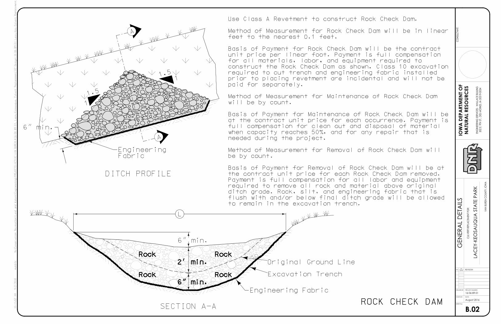
B.02
GE
NER
AL D
ETAIL
S
ROCK CHECK DAM
DITCH PROFILE
SECTION A-A
A
L
6" min.
Engineering Fabric
Excavation Trench
Original Ground Line
11.5
1.5
1
6" min.
A
FabricEngineering
to remain in the excavation trench.
flush with and/or below final ditch grade will be allowed
ditch grade. Rock, silt, and engineering fabric that is
required to remove all rock and material above original
Payment is full compensation for all labor and equipment
the contract unit price for each Rock Check Dam removed.
Basis of Payment for Removal of Rock Check Dam will be at
be by count.
Method of Measurement for Removal of Rock Check Dam will
needed during the project.
when capacity reaches 50%, and for any repair that is
full compensation for clean out and disposal of material
at the contract unit price for each occurrence. Payment is
Basis of Payment for Maintenance of Rock Check Dam will be
will be by count.
Method of Measurement for Maintenance of Rock Check Dam
paid for separately.
prior to placing revetment are incidental and will not be
required to cut trench and engineering fabric installed
construct the Rock Check Dam as shown. Class 10 excavation
for all materials, labor, and equipment required to
unit price per linear foot. Payment is full compensation
Basis of Payment for Rock Check Dam will be the contract
feet to the nearest 0.1 feet.
Method of Measurement for Rock Check Dam will be in linear
Use Class A Revetment to construct Rock Check Dam.
6" min.
2’ min.
Rock
Rock Rock
Rock
LA
CE
Y-K
EO
SA
UQ
UA S
TA
TE P
AR
K
CU
LV
ER
T R
EP
LA
CE
ME
NT F
OR:
16-06-89-01
VA
N B
UR
EN C
OU
NTY, IO
WA
August 2016
PROJECT NUMBER:
DATE:
NO.DATE
BYREVISION
DRAWN BY:
CHK’D BY:
NA
TU
RA
L R
ES
OU
RC
ES
IOW
A D
EP
ART
ME
NT O
F
502 E. 9TH S
T., D
ES M
OIN
ES, IA 5
0319-0
034
EN
GIN
EERIN
G S
ER
VIC
ES - W
ALLA
CE B
UILIN
G
CO
NS
ULTA
NT:
SHEET No:
10:11:52
AM
9/2/2016
maldric
N:\
Conservation
Recreation\
Land and
Waters\
Engineering\
PR
OJ
EC
TS\
AC
TI
VE\
VA
N
BU
RE
N\#
16-06-89-01,
Lacey-
Keosauqua,
Culvert
Replace
ment\02
Design\16-06-89-01
Lacey-
Keo
Culvert
Replace
ment_
B02.dgn

B.03
GE
NER
AL D
ETAIL
S
6"
1’-8" W
W WD D
42"
36"
30"
24"
18"
15"
12"
4f2
4f1
4f2
4f1
4f2
4f1
4f2
4f1
4f2
4f1
4f2
4f1
4f2
4f1
Mark
4
4
4
4
4
4
4
4
4
4
4
4
4
4
Size
5
3
5
3
4
3
3
3
3
3
2
3
2
3
Count
4f2
4f1
4f2
4f1
4f2
4f1
4f2
4f1
4f2
4f1
4f2
4f1
4f2
4f1
Mark
4
4
4
4
4
4
4
4
4
4
4
4
4
4
Size
3’-8"
10’-9"
3’-8"
10’-3"
3’-8"
9’-8"
3’-8"
8’-7"
3’-8"
8’-7"
3’-8"
8’-1"
3’-8"
7’-6"
Length
8
3
7
3
7
3
6
3
6
3
6
3
6
3
Count
84"
78"
72"
66"
60"
54"
48"
11’-1"
10’-7"
10’-0"
8’-11"
8’-11"
8’-5"
7’-10"
TYPICAL SECTION ELEVATION
RCP Apron Section
D
48"48"
Section
RCP Apron
4f1
4f2
#4 Bars @ 18" o.c.
21
REINFORCING BAR LIST
RCP APRON SECTION FOOTING
�
3’-8"
6’-11"
3’-8"
6’-4"
3’-8"
5’-3"
3’-8"
4’-2"
3’-8"
3’-1"
3’-8"
2’-6 "
3’-8"
2’-0"
Length
7’-3"
6’-8"
5’-7"
4’-6"
3’-5"
2’-10 "
2’-4"
LA
CE
Y-K
EO
SA
UQ
UA S
TA
TE P
AR
K
CU
LV
ER
T R
EP
LA
CE
ME
NT F
OR:
16-06-89-01
VA
N B
UR
EN C
OU
NTY, IO
WA
August 2016
PROJECT NUMBER:
DATE:
NO.DATE
BYREVISION
DRAWN BY:
CHK’D BY:
NA
TU
RA
L R
ES
OU
RC
ES
IOW
A D
EP
ART
ME
NT O
F
502 E. 9TH S
T., D
ES M
OIN
ES, IA 5
0319-0
034
EN
GIN
EERIN
G S
ER
VIC
ES - W
ALLA
CE B
UILIN
G
CO
NS
ULTA
NT:
SHEET No:
10:11:53
AM
9/2/2016
maldric
N:\
Conservation
Recreation\
Land and
Waters\
Engineering\
PR
OJ
EC
TS\
AC
TI
VE\
VA
N
BU
RE
N\#
16-06-89-01,
Lacey-
Keosauqua,
Culvert
Replace
ment\02
Design\16-06-89-01
Lacey-
Keo
Culvert
Replace
ment_
B03.dgn

B.04
GE
NER
AL D
ETAIL
S
TYPICAL SECTION
ELEVATION
2’
MI
N.
3’ TYP. 3’ TYP.
Section
RCP Apron
Section
RCP Apron
Class "E" Revetment
2’
MI
N.
5’ MIN.
FS
Footing
6"
Section
RCP Apron
Fabric
Engineering
Fabric
Engineering
Fabric
Engineering
6"
6"
Class "E" Revetment
Footing Footing
2’
MI
N.
LA
CE
Y-K
EO
SA
UQ
UA S
TA
TE P
AR
K
CU
LV
ER
T R
EP
LA
CE
ME
NT F
OR:
16-06-89-01
VA
N B
UR
EN C
OU
NTY, IO
WA
August 2016
PROJECT NUMBER:
DATE:
NO.DATE
BYREVISION
DRAWN BY:
CHK’D BY:
NA
TU
RA
L R
ES
OU
RC
ES
IOW
A D
EP
ART
ME
NT O
F
502 E. 9TH S
T., D
ES M
OIN
ES, IA 5
0319-0
034
EN
GIN
EERIN
G S
ER
VIC
ES - W
ALLA
CE B
UILIN
G
CO
NS
ULTA
NT:
SHEET No:
10:11:53
AM
9/2/2016
maldric
N:\
Conservation
Recreation\
Land and
Waters\
Engineering\
PR
OJ
EC
TS\
AC
TI
VE\
VA
N
BU
RE
N\#
16-06-89-01,
Lacey-
Keosauqua,
Culvert
Replace
ment\02
Design\16-06-89-01
Lacey-
Keo
Culvert
Replace
ment_
B04.dgn
CONSTRUCTION NOTES:
PROTECTION DETAILSEMBANKMENT
B, 3 OF THE STANDARD SPECIFICATIONS.
REQUIREMENTS IN ACCORDANCE WITH ARTICLE 4196.01,
THE ENGINEERING FABRIC SHALL MEET THE MATERIAL
SPECIFICATIONS.
ACCORDING TO ARTICLE 2507.03 OF THE STANDARD
CLASS E REVETMENT SHOULD BE USED AND PLACED
QU
AN
TITIE
S & N
OTES
C.01
ESTIMATED PROJECT QUANTITIES
ITEM NO. ITEM UNIT TOTAL
LA
CE
Y-K
EO
SA
UQ
UA S
TA
TE P
AR
K
CU
LV
ER
T R
EP
LA
CE
ME
NT F
OR:
16-06-89-01
VA
N B
UR
EN C
OU
NTY, IO
WA
August 2016
ESTIMATE REFERENCE INFORMATION
DESCRIPTIONITEM
NO.
PROJECT NUMBER:
DATE:
NO.DATE
BYREVISION
DRAWN BY:
CHK’D BY:
NA
TU
RA
L R
ES
OU
RC
ES
IOW
A D
EP
ART
ME
NT O
F
502 E. 9TH S
T., D
ES M
OIN
ES, IA 5
0319-0
034
EN
GIN
EERIN
G S
ER
VIC
ES - W
ALLA
CE B
UILIN
G
CO
NS
ULTA
NT:
SHEET No:
10:11:55
AM
9/2/2016
maldric
N:\
Conservation
Recreation\
Land and
Waters\
Engineering\
PR
OJ
EC
TS\
AC
TI
VE\
VA
N
BU
RE
N\#
16-06-89-01,
Lacey-
Keosauqua,
Culvert
Replace
ment\02
Design\16-06-89-01
Lacey-
Keo
Culvert
Replace
ment_
C01.dgn
(8th & 9th in 2016).
NOTE: Construction is not allowed to begin prior to the Scenic Drive Festival the second full weekend of October
LS
LS
LS
LF
ACRE
LS
TON
LF
CY
CY
CY
CY
CY
EACH
LF
EACH
EACH
EACH
EACH
LF
TON
SY
STA
SY
LF
SY
LF
LS
LS
site is stabilized.
remain in place and be maintained during construction. DNR Park staff will remove once the
A. Filter sock shall be installed to prevent sediment from exiting the project site and shall
EROSION CONTROL25
A. DOT Standard Road Plan DR-101
FLOODED BACKFILL20
A. DOT Standard Road Plan DR-101
FLOWABLE MORTAR19
be allowed.
A. A suitable borrow site shall be obtained by the contractor. No payment for overhaul will
EMBANKMENT-IN-PLACE18
EXCAVATION, CLASS 2017
EXCAVATION, CLASS 10, ROADWAY AND BORROW16
A. The parking area at the park will be 6" Class "A" Crushed Stone..
CLASS "A" CRUSHED STONE9
provided it meets the gradation requirements.
B. The contractor may crush ACC from the pavement removal and use as recycled material
A. Existing ACC from pavement removal shall be used on the project as a special backfill.
SPECIAL BACKFILL8
A. No payment for overhaul will be allowed for earth shoulder material.
SHOULDER CONSTRUCTION, EARTH7
A. Joints shall be sawcut at standard spacing, 12’ maximum.
PAVING, P.C. CONCRETE, 7"6
A. The contractor shall cut the existing pavement as indicated in the plan sheets.
SAW CUTTING EXISTING ASPHALT PAVEMENT5
C. Overhaul shall be considered incidental.
B. Disposal is the responsibility of the contractor.
A. The contractor shall remove the existing pavement as indicated in the plan sheets.
REMOVAL OF EXISTING PAVEMENT4
C. Overhaul shall be considered incidental.
B. Disposal is the responsibility of the contractor.
A. The contractor shall remove the existing pipes as indicated in the plan sheets.
REMOVAL OF EXISTING PIPE3
C. Overhaul shall be considered incidental.
B. Disposal is the responsibility of the contractor.
A. The contractor shall remove the existing structure as indicated in the plan sheets.
REMOVAL OF EXISTING STRUCTURE2
B. Disposal is the responsibility of the contractor.
DNR Inspector.
A. Includes the removal and disposal of trees as shown in the plans and as directed by the
CLEARING AND GRUBBING1
1
1
1
895
0.11
1
40
24
93.6
18.4
248.5
10.0
31.7
2
22
1
6
2
4
112
11
867
7
788.1
40
709.5
22
1
1
28
27
26
25
24
23
22
21
20
19
18
17
16
15
14
13
12
11
10
9
8
7
6
5
4
3
2
1
MOBILIZATION
CONSTRUCTION STAKING
TRAFFIC CONTROL
EROSION CONTROL
SEEDING, FERTILIZING AND MULCHING
FINISH GRADING
REVETMENT, CLASS E
ROCK CHECK DAM
FLOODED BACKFILL
FLOWABLE MORTAR
EMBANKMENT-IN-PLACE
EXCAVATION, CLASS 20
EXCAVATION, CLASS 10, ROADWAY AND BORROW
APRON, LOW CLEARANCE CONCRETE, EQUIV. DIAM. 18 IN.
CULVERT, LOW CLEARANCE CONCRETE ENTRANCE PIPE, EQUIV. DIAM. 18 IN.
PIPE FOOTING
APRON GUARD, DR-213
APRON, LOW CLEARANCE CONCRETE, EQUIV. DIAM. 30 IN.
CULVERT, LOW CLEARANCE CONCRETE ROADWAY PIPE, EQUIV. DIAM. 30 IN.
CLASS "A" CRUSHED STONE
SPECIAL BACKFILL
SHOULDER CONSTRUCTION, EARTH
PAVING, P.C. CONCRETE, 7"
SAW CUTTING EXISTING ASPHALT PAVEMENT
REMOVAL OF PAVEMENT
REMOVAL OF EXISTING PIPE
REMOVAL OF EXISTING STRUCTURE
CLEARING AND GRUBBING

C.02
GE
NER
AL N
OTES
LA
CE
Y-K
EO
SA
UQ
UA S
TA
TE P
AR
K
CU
LV
ER
T R
EP
LA
CE
ME
NT F
OR:
16-06-89-01
VA
N B
UR
EN C
OU
NTY, IO
WA
August 2016
GENERAL NOTES
PROJECT NUMBER:
DATE:
NO.DATE
BYREVISION
DRAWN BY:
CHK’D BY:
NA
TU
RA
L R
ES
OU
RC
ES
IOW
A D
EP
ART
ME
NT O
F
502 E. 9TH S
T., D
ES M
OIN
ES, IA 5
0319-0
034
EN
GIN
EERIN
G S
ER
VIC
ES - W
ALLA
CE B
UILIN
G
CO
NS
ULTA
NT:
SHEET No:
10:11:56
AM
9/2/2016
maldric
N:\
Conservation
Recreation\
Land and
Waters\
Engineering\
PR
OJ
EC
TS\
AC
TI
VE\
VA
N
BU
RE
N\#
16-06-89-01,
Lacey-
Keosauqua,
Culvert
Replace
ment\02
Design\16-06-89-01
Lacey-
Keo
Culvert
Replace
ment_
C02.dgn
be subject to the approval of the DNR Engineer.
equipment or use these areas for storage of materials. Storage, parking and service areas will
construction limits. The contractor will not be permitted to park or service vehicles and
N. The contractor shall not disturb desirable grass areas and desirable trees outside the
or delay caused by such work.
No claims for additional compensation will be allowed to the contractor for any interference
responsibility to determine their existence and exact location and to avoid damage thereto.
others, the existence of which is presently not known or shown. It is the contractor’s
therefore their locations must be considered approximate only. It is possible there may be
facilities, structures and utilities have been plotted from available surveys and records and
afforded access to these facilities for necessary modification of services. Underground
Engineer of those utilities prior to the beginning of any construction. The contractor shall be
construction area, it shall be the responsibility of the contractor to notify the DNR
M. Where utilities and fixtures are shown as existing on the plans or encountered within the
Backfill to the top of all rock or paved surfaces.L.
The contractor shall seed, fertilize and mulch all disturbed areas. Use Class "C" seed mixture.K.
Topsoil shall be spread to a minimum thickness of 6 inches on all disturbed unpaved areas. J.
to finish grade.
The contractor shall shape graded area to maintain surface drainage. All elevations shown are I.
silt fence, rock ditch checks, silt basins or silt dikes.
to install and maintain erosion control features of the project. This may involve seeding,
The contractor is expected to have materials, equipment, and labor available on a daily basis H.
considered incidental to other bid items in the project.
any such operations shall be restored to an applicable condition. This operation shall be
the right of way or project limits (including borrow areas and operation sites) disturbed by
practical - preferably the day created and not later than the following day. Any portion of
directed by the Engineer to prevent future settlement. The voids shall be filled as soon as
fence posts, utility poles or piers, shall be filled and consolidated to finish grade as
All holes resulting from operations of the contractor, including removal of guardrail posts, G.
right-of-way, unless specifically stated in the plans or approved by the DNR Engineer.
allowed for material hauled to these sites. No material shall be placed within the
incorporated into the work involved on this project. No payment for overhaul will be
excess material (excavated material or broken concrete) which is not desirable to be
F. It shall be the contractor’s responsibility to provide waste areas or disposal sites for
ordinances.
All work shall conform to and be preformed in accordance with all applicable codes and E.
owner.
their negligence, or that of a subcontractor, and said repairs shall be approved by the
D. The contractor shall be responsible for any damage to existing facilities resulting from
proceeding with the work.
shall notify the DNR Engineer of any discrepancies, omissions, and/or conflicts prior to
C. The contractor shall verify, at the site, all dimensions and conditions shown on the plans and
to the plans, specification, special provisions and contract.
visit the project site shall not relieve the contractor from performing the work in accordance
themselves with the actual job conditions prior to bidding and the start of work. Failure to
The contractor shall visit the site and inspect the project area and thoroughly familiarize B.
District Inspector: Mike Dufoe (515) 985-9196a.
The contractor shall notify the following two weeks prior to demolition and/ or construction:A.

PROJECT NUMBER:
DATE:
NO.DATE
BYREVISION
DRAWN BY:
CHK’D BY:
NA
TU
RA
L R
ES
OU
RC
ES
IOW
A D
EP
ART
ME
NT O
F
502 E. 9TH S
T., D
ES M
OIN
ES, IA 5
0319-0
034
EN
GIN
EERIN
G S
ER
VIC
ES - W
ALLA
CE B
UILIN
G
CO
NS
ULTA
NT:
SHEET No:
10:12:05
AM
9/2/2016
maldric
N:\
Conservation
Recreation\
Land and
Waters\
Engineering\
PR
OJ
EC
TS\
AC
TI
VE\
VA
N
BU
RE
N\#
16-06-89-01,
Lacey-
Keosauqua,
Culvert
Replace
ment\02
Design\16-06-89-01
Lacey-
Keo
Culvert
Replace
ment_
D01.dgn
LA
CE
Y-K
EO
SA
UQ
UA S
TA
TE P
AR
K
CU
LV
ER
T R
EP
LA
CE
ME
NT F
OR:
16-06-89-01
VA
N B
UR
EN C
OU
NTY, IO
WA
August 2016
250’ Filter Sock
250’ Filter Sock
150’ Filter Sock
FL=575.64
125’ Filter Sock
120’ Filter Sock
Rock Check Dam
FL=575.91
30° Lt Ahead
56’-30" Equivalent Arch RCP
Sta. 11+39.72
Sta. 11+30.82 &
Riprap
Riprap50’
Mini
mum
28.8’
27.2’
Footing and Guards
RCP Aprons with
30" Equivalent Arch
to Drain
Ditches
Grade All *
Footings
RCP Aprons with
30" Equivalent Arch
FL=579.50
RCP Aprons with Footing
40’- 18" Equivalent Arch
Sta. 10+20.01, 20.9’ RT
FL=578.30
RCP Aprons with Footing
40’- 18" Equivalent Arch
Sta. 10+60, 19.9’ RT
10
+00
11
+00
12+00
13+00
14+00
11
+20.16
PC
12+60.26
PT
0+00
1+00
575.70
12"CMP
+575.73
12"CMP
+575.81
12"CMP
+575.86
12"
CM
P
+
575.87
12"C
MP
+575.97
12"C
MP
+576.00
576.04
576.04
"C
MP
+
576.04
576.05
576.05
12"C
MP
+
+
18"CMP FLOW 578.30
+
18"CMP FLOW 579.01
PLA
N S
HEET
D.01
O
FEET
3O

PR
OFIL
E S
HEET
D.02
PROJECT NUMBER:
DATE:
NO.DATE
BYREVISION
DRAWN BY:
CHK’D BY:
NA
TU
RA
L R
ES
OU
RC
ES
IOW
A D
EP
ART
ME
NT O
F
502 E. 9TH S
T., D
ES M
OIN
ES, IA 5
0319-0
034
EN
GIN
EERIN
G S
ER
VIC
ES - W
ALLA
CE B
UILIN
G
CO
NS
ULTA
NT:
SHEET No:
10:12:06
AM
9/2/2016
maldric
N:\
Conservation
Recreation\
Land and
Waters\
Engineering\
PR
OJ
EC
TS\
AC
TI
VE\
VA
N
BU
RE
N\#
16-06-89-01,
Lacey-
Keosauqua,
Culvert
Replace
ment\02
Design\16-06-89-01
Lacey-
Keo
Culvert
Replace
ment_
D02.dgn
LA
CE
Y-K
EO
SA
UQ
UA S
TA
TE P
AR
K
CU
LV
ER
T R
EP
LA
CE
ME
NT F
OR:
16-06-89-01
VA
N B
UR
EN C
OU
NTY, IO
WA
August 2016-
PVI 10
+11.53
Elev 581.79
PV
C 10
+11.71
Elev 581.78
PVI 10
+55.21
Elev 580.17
PV
T 10
+98.71
Elev 580.06
PV
C 12
+95.02
Elev 579.57
PVI 13
+20.02
Elev 579.51
PV
T 13
+45.02
Elev 579.33
PVI 13
+58.16
Elev 579.24
-3.70%
-0.25%-0.71%
L 87.00’
e 0.38’
K 25.19
R 3.97
L 50.00’
e -0.03’
K 108.76
R -0.92
580
570
590
570
580
590
10+00 11+00 12+00 13+00 14+0014+00
10+46.05 - Prop. Type C Ent. Rt.
580
580.54
10’ Rt
580.61
18’ Rt
0.89%
18" Equivalent Arch RCP
30" Equivalent Arch RCP
56’ - Double

D.03
PR
OFIL
E S
HEET
FL=575.64FL=575.91
Road Elv = 579.97
30° Lt Ahead
@ 0.48%
30" Equivalent Arch RCP
56’ - Double
PROJECT NUMBER:
DATE:
NO.DATE
BYREVISION
DRAWN BY:
CHK’D BY:
NA
TU
RA
L R
ES
OU
RC
ES
IOW
A D
EP
ART
ME
NT O
F
502 E. 9TH S
T., D
ES M
OIN
ES, IA 5
0319-0
034
EN
GIN
EERIN
G S
ER
VIC
ES - W
ALLA
CE B
UILIN
G
CO
NS
ULTA
NT:
SHEET No:
10:12:08
AM
9/2/2016
maldric
N:\
Conservation
Recreation\
Land and
Waters\
Engineering\
PR
OJ
EC
TS\
AC
TI
VE\
VA
N
BU
RE
N\#
16-06-89-01,
Lacey-
Keosauqua,
Culvert
Replace
ment\02
Design\16-06-89-01
Lacey-
Keo
Culvert
Replace
ment_
D03.dgn
LA
CE
Y-K
EO
SA
UQ
UA S
TA
TE P
AR
K
CU
LV
ER
T R
EP
LA
CE
ME
NT F
OR:
16-06-89-01
VA
N B
UR
EN C
OU
NTY, IO
WA
August 2016
-
580
570 570
580
0+00 1+00 2+00
28.8’ 27.2’
PROJECT NUMBER:
DATE:
NO.DATE
BYREVISION
DRAWN BY:
CHK’D BY:
NA
TU
RA
L R
ES
OU
RC
ES
IOW
A D
EP
ART
ME
NT O
F
502 E. 9TH S
T., D
ES M
OIN
ES, IA 5
0319-0
034
EN
GIN
EERIN
G S
ER
VIC
ES - W
ALLA
CE B
UILIN
G
CO
NS
ULTA
NT:
SHEET No:
10:12:10
AM
9/2/2016
maldric
N:\
Conservation
Recreation\
Land and
Waters\
Engineering\
PR
OJ
EC
TS\
AC
TI
VE\
VA
N
BU
RE
N\#
16-06-89-01,
Lacey-
Keosauqua,
Culvert
Replace
ment\02
Design\16-06-89-01
Lacey-
Keo
Culvert
Replace
ment_
E01.dgn
LA
CE
Y-K
EO
SA
UQ
UA S
TA
TE P
AR
K
CU
LV
ER
T R
EP
LA
CE
ME
NT F
OR:
16-06-89-01
VA
N B
UR
EN C
OU
NTY, IO
WA
August 2016
HMA Pavement
Existing
Remove
HMA Pavement
Existing
Remove
Crossing Structure
PCC Low Water
Remove Existing
Corrugated Metal Pipe
Remove Existing
Install Rock Check Dam
Tree Removal to
575.70
12"
CM
P
+575.73
12"
CM
P
+575.81
12"
CM
P
+575.86
12"CMP
+
575.87
12"C
MP
+575.97
12"C
MP
+576.00
576.04
576.04
"C
MP
+
576.04
576.05
576.05
12"C
MP
+
+
18"
CM
P
FL
OW 578.30
+
18"
CM
P
FL
OW 579.01
E.01
DE
MO
LITIO
N S
HEET
O
FEET
5O

PROJECT NUMBER:
DATE:
NO.DATE
BYREVISION
DRAWN BY:
CHK’D BY:
NA
TU
RA
L R
ES
OU
RC
ES
IOW
A D
EP
ART
ME
NT O
F
502 E. 9TH S
T., D
ES M
OIN
ES, IA 5
0319-0
034
EN
GIN
EERIN
G S
ER
VIC
ES - W
ALLA
CE B
UILIN
G
CO
NS
ULTA
NT:
SHEET No:
10:12:12
AM
9/2/2016
maldric
N:\
Conservation
Recreation\
Land and
Waters\
Engineering\
PR
OJ
EC
TS\
AC
TI
VE\
VA
N
BU
RE
N\#
16-06-89-01,
Lacey-
Keosauqua,
Culvert
Replace
ment\02
Design\16-06-89-01
Lacey-
Keo
Culvert
Replace
ment_
G01.dgn
LA
CE
Y-K
EO
SA
UQ
UA S
TA
TE P
AR
K
CU
LV
ER
T R
EP
LA
CE
ME
NT F
OR:
16-06-89-01
VA
N B
UR
EN C
OU
NTY, IO
WA
August 2016
575.70
12"
CM
P
+575.73
12"
CM
P
+575.81
12"
CM
P
+575.86
12"CMP
+
575.87
12"C
MP
+575.97
12"C
MP
+576.00
576.04
576.04
"C
MP
+
576.04
576.05
576.05
12"C
MP
+
+
18"
CM
P
FL
OW 578.30
+
18"
CM
P
FL
OW 579.01
264530.8290
2064895.3340
579.175Elev:
E:
N:1735
PK NAIL ASPHALT
CP 1735
PK NAIL ASPHALT
CP 1734
264324.2420
2064795.9660
580.982Elev:
E:
N:1734
G.01
SU
RV
EY C
ON
TR
OL
Description Elev EastingPoint Northing
PK NAIL 1 5/32 EDGE ASPHALT EDGE OF PULL OVER AREA1735 264530.829 2064895.33 579.175
PK NAIL 1 5/32 EDGE ASPHALT 264324.242 2064796.66 580.9821734
O
FEET
5O

PROJECT NUMBER:
DATE:
NO.DATE
BYREVISION
DRAWN BY:
CHK’D BY:
NA
TU
RA
L R
ES
OU
RC
ES
IOW
A D
EP
ART
ME
NT O
F
502 E. 9TH S
T., D
ES M
OIN
ES, IA 5
0319-0
034
EN
GIN
EERIN
G S
ER
VIC
ES - W
ALLA
CE B
UILIN
G
CO
NS
ULTA
NT:
SHEET No:
10:12:13
AM
9/2/2016
maldric
N:\
Conservation
Recreation\
Land and
Waters\
Engineering\
PR
OJ
EC
TS\
AC
TI
VE\
VA
N
BU
RE
N\#
16-06-89-01,
Lacey-
Keosauqua,
Culvert
Replace
ment\02
Design\16-06-89-01
Lacey-
Keo
Culvert
Replace
ment_
G02.dgn
LA
CE
Y-K
EO
SA
UQ
UA S
TA
TE P
AR
K
CU
LV
ER
T R
EP
LA
CE
ME
NT F
OR:
16-06-89-01
VA
N B
UR
EN C
OU
NTY, IO
WA
August 2016
G.02
SU
RV
EY C
ON
TR
OL
Tangent Length: 139.78
Tangent Direction: N 49°59’10" E
POE ( ) 14+00.04 264617.45 2064983.54
PT ( ) 12+60.26 264527.57 2064876.48
Element: Linear
Tangent Direction: N 49°59’10" E
Radial Direction: S 40°00’50" E
Chord Direction: N 31°44’36" E
Radial Direction: S 76°29’59" E
Tangent Direction: N 13°30’01" E
External: 11.64
Middle Ordinate: 11.06
Chord: 137.74
Tangent: 72.51
Length: 140.10
Degree of Curvature(Arc): 26°02’37"
Delta: 36°29’09" Right
Superelevation: 6.000%
Design Speed(mph): 30.00
Radius: 220.00
PT ( ) 12+60.26 264527.57 2064876.48
CC ( ) 264359.08 2065017.93
PI ( ) 11+92.68 264480.95 2064820.94
PC ( ) 11+20.16 264410.44 2064804.01
Element: Circular
Tangent Length: 120.16
Tangent Direction: N 13°30’01" E
PC ( ) 11+20.16 264410.44 2064804.01
POB ( ) 10+00.00 264293.59 2064775.96
Element: Linear
STATION NORTHING EASTING
Roadway
Tangent Length: 39.39
Tangent Direction: N 45°46’45" W
POE ( ) 1+66.55 264480.86 2064754.13
PI ( ) 1+27.16 264453.38 2064782.36
Element: Linear
Tangent Length: 78.83
Tangent Direction: N 42°08’52" W
PI ( ) 1+27.16 264453.38 2064782.36
PI ( ) 0+48.32 264394.93 2064835.26
Element: Linear
Tangent Length: 48.32
Tangent Direction: N 26°49’56" W
PI ( ) 0+48.32 264394.93 2064835.26
POB ( ) 0+00.00 264351.81 2064857.07
Element: Linear
STATION NORTHING EASTING
Channel