Embed Size (px)
Citation preview
Student GuideBook-DGU
`1 | P a g e
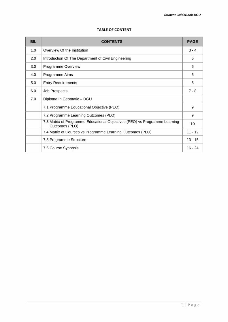
TABLE OF CONTENT
BIL CONTENTS PAGE
1.0 Overview Of the Institution 3 - 4
2.0 Introduction Of The Department of Civil Engineering 5
3.0 Programme Overview 6
4.0 Programme Aims 6
5.0 Entry Requirements 6
6.0 Job Prospects 7 - 8
7.0 Diploma In Geomatic – DGU
7.1 Programme Educational Objective (PEO) 9
7.2 Programme Learning Outcomes (PLO) 9
7.3 Matrix of Programme Educational Objectives (PEO) vs Programme Learning Outcomes (PLO)
10
7.4 Matrix of Courses vs Programme Learning Outcomes (PLO) 11 - 12
7.5 Programme Structure 13 - 15
7.6 Course Synopsis 16 - 24

Student GuideBook-DGU
`2 | P a g e
DKA: DIPLOMA IN CIVIL ENGINEERING
DGU: DIPLOMA IN GEOMATIC
DSB: DIPLOMA IN ARCHITECTURE
CIVIL ENGINEERING DEPARTMENT Politeknik Sultan Haji Ahmad Shah, Semambu, 25350 Kuantan, Pahang Darul Makmur. Tel No: 09-5655300 Fax No: 09-5663104 Web: www.polisas.edu.my Facebook: politeknik.edu
STUDENT PROGRAMME GUIDE
CIVIL ENGINEERING DEPARTMENT
Student GuideBook-DGU
`3 | P a g e
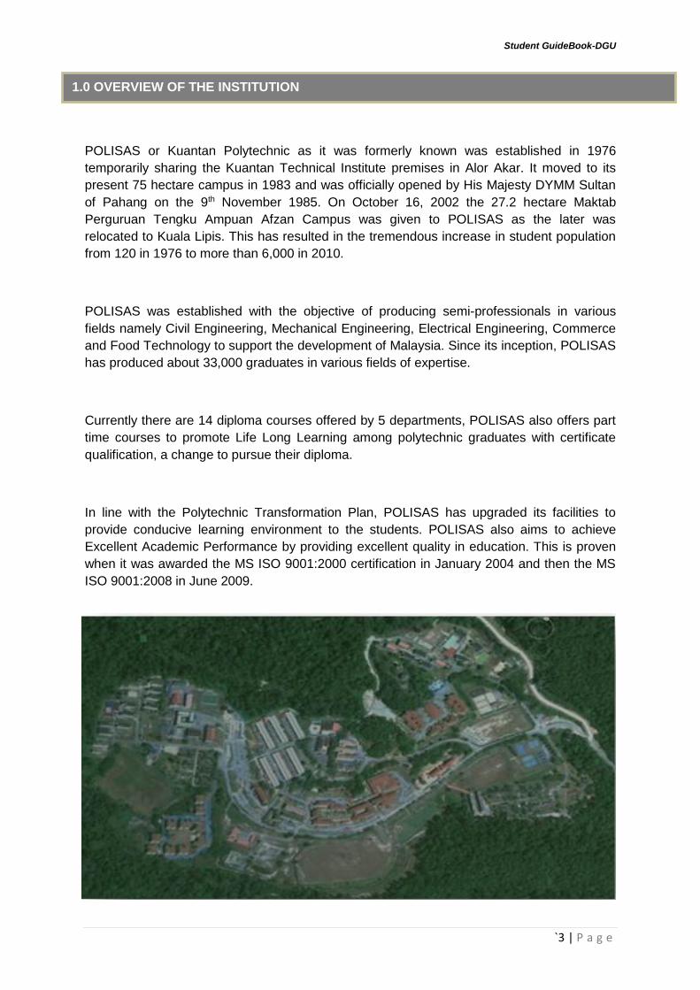
POLISAS or Kuantan Polytechnic as it was formerly known was established in 1976
temporarily sharing the Kuantan Technical Institute premises in Alor Akar. It moved to its
present 75 hectare campus in 1983 and was officially opened by His Majesty DYMM Sultan
of Pahang on the 9th November 1985. On October 16, 2002 the 27.2 hectare Maktab
Perguruan Tengku Ampuan Afzan Campus was given to POLISAS as the later was
relocated to Kuala Lipis. This has resulted in the tremendous increase in student population
from 120 in 1976 to more than 6,000 in 2010.
POLISAS was established with the objective of producing semi-professionals in various
fields namely Civil Engineering, Mechanical Engineering, Electrical Engineering, Commerce
and Food Technology to support the development of Malaysia. Since its inception, POLISAS
has produced about 33,000 graduates in various fields of expertise.
Currently there are 14 diploma courses offered by 5 departments, POLISAS also offers part
time courses to promote Life Long Learning among polytechnic graduates with certificate
qualification, a change to pursue their diploma.
In line with the Polytechnic Transformation Plan, POLISAS has upgraded its facilities to
provide conducive learning environment to the students. POLISAS also aims to achieve
Excellent Academic Performance by providing excellent quality in education. This is proven
when it was awarded the MS ISO 9001:2000 certification in January 2004 and then the MS
ISO 9001:2008 in June 2009.
1.0 OVERVIEW OF THE INSTITUTION

Student GuideBook-DGU
`4 | P a g e
POLYTECHNIC POLICY
The National Education Philosophy
“Education in Malaysia is an on-going effort towards further developing the potential of
individuals in a holistic and integrated manner, so as to produce individuals who are
intellectually, spiritually, emotionally and physically balanced and harmonic based on a firm
belief in and devotion to God. Such as effort is designed to produce Malaysian citizens who
are knowledgeable and competent, who possess high moral standards and who are
responsible and capable of achieving high level of personal well-being as well as being able
to contribute to the harmony and betterment of the family, the society and the nation at
large.”
Our Vision
To be the leading provider of innovative human capital through transformational education
and training to fulfil the needs of the global workforce.
Our Mission
To push the boundaries in building a transformative and creative learning environmental
to generate an innovation-led economy.
Client’s Charter
With full determination and a sense of responsibility, POLISAS promises to ensure:
1. The providing of semi-professional service meets the standard stated in the Quality
Policy
2. A conducive learning environmental is met
3. An effective and competitive administration system to produce committed staff and
well-rounded graduates
4. Certification is awarded within the stipulated timeframe and requirements
5. Semi-professional manpower is developed based on technology in line with me
nation’s vision.

Student GuideBook-DGU
`5 | P a g e
2.0 INTRODUCTION TO THE DEPARTMENT OF CIVIL ENGINEERING

Student GuideBook-DGU
`6 | P a g e
DIPLOMA IN GEOMATIC – DGU
This programme provides students with knowledge and generates skill in the field of land
survey especially on measurement and positioning technique, geospatial data capture, data
processing, data analysis and map presentation. Among the courses offered in this
programme is Cadastral Surveying, Survey Computation, Engineering Surveying
Hydrographic Surveying, Utility Mapping, Geodesy, Astronomy, Survey Adjustment,
CADD, Geographical Information System (GIS), Photogrammetry, Remote Sensing,
Cartography, Land Law & Regulations, Land Management and Development, Town and
Regional Planning and Visual Basic Programming. In addition to the technical courses,
students are also taught Communicative English, Engineering Mathematics, Engineering
Science, Pengajian Malaysia, Sains Teknologi dan Kejuruteraan Islam, Nilai
Masyarakat Malaysia, Komunikasi dan Penyiaran Islam, Co-Curriculum, Occupational
Safety and Health and Entrepreneurship to enhance their competencies in soft skills.
The graduates from this programme will have the potentials to work in both private and
government sector locally and abroad. In addition, they also have the opportunities to
further their studies in other higher learning institutions locally and abroad
The Diploma in Geomatic graduates in Polytechnics, Ministry of Education will have
knowledge, technical skills and attitude to adapt themselves with new technological
advancement and challenges in geomatic fields.
The general minimum requirement for student entry:
1) Malaysian
2) Passed “Sijil Pelajaran Malaysia” (SPM) or equivalent qualification with minimum
requirement as follow:
Passed Bahasa Melayu
Passed English
Passed Sejarah (for SPM 2013 onwards)
Passed THREE (3) subject with minimum Grade C
Maths / Add Maths
ONE (1) Science / Technical / Vocational
ONE (1) any other subject
3) Candidates are not color blind and physically handicapped that will complicate
practical assignments.
3.0 PROGRAMME OVERVIEW
4.0 PROGRAMME AIMS
5.0 ENTRY REQUIREMENTS

Student GuideBook-DGU
`7 | P a g e
This programme provides the knowledge and skills in geomatic and geospatial
industry. The programme can also be applied to a broad range of careers available. The
knowledge and skills that the students acquire from the program will enable them to
participate in the job market such as:
Assistant Surveyor
Assistant Land Officer
Land Survey Site Supervisor
Land Survey Draughtsman
Assistant Hydrographic Surveyor
Assistant Information System Officer (GIS)
Assistant Information System Officer (Remote Sensing)
6.0 JOB PROSPECTS
Student GuideBook-DGU
`8 | P a g e
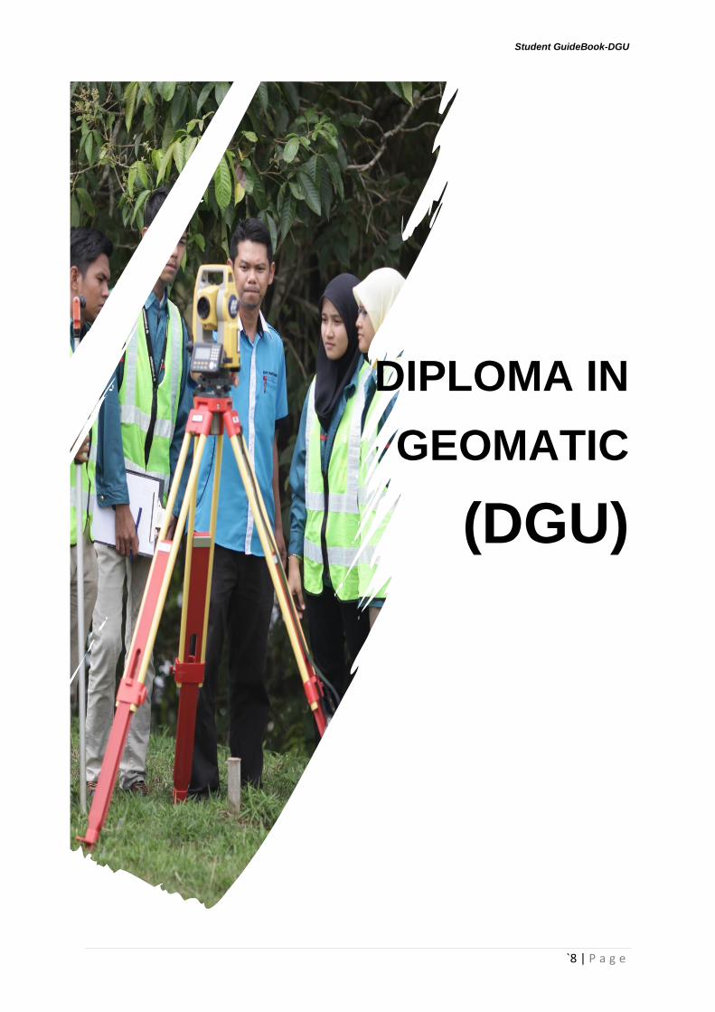
DIPLOMA IN
GEOMATIC
(DGU)

Student GuideBook-DGU
`9 | P a g e
7.1 PROGRAMME EDUCATIONAL OBJECTIVES (PEO)
The Diploma in Geomatic programme shall produce semi-professionals who are:
1. Knowledgeable, technically competent in geomatic discipline and able to adapt
themselves with new technological advancement and challenges in geomatic fields.
2. Effective in communication and social responsibilities, able to become a leader and
work as a team.
3. Practicing good work ethics, able to promote good morality and behaviour and
will continuously enhance their knowledge and skills.
4. Able to solve managerial and field problems and possess entrepreneur skills
to prepare themselves for future challenges
7.2 PROGRAMME LEARNING OUTCOMES (PLO)
The Diploma in Geomatic programme shall produce semi-professionals who are able to:
1. Apply technical knowledge and social science/humanities knowledge to well defined
land survey problems and to the personality development of an individual,
respectively.
2. Demonstrate practical skills in utilising appropriate techniques and surveying
instruments to well-defined surveying activities.
3. Communicate effectively with the related discipline in surveying field, engineering
community and the society at large.
4. Solve related well-defined land survey problems systematically using appropriate
tools and techniques.
5. Demonstrate awareness and consideration for societal, health, safety, legal and
cultural issues and the consequent responsibilities.
6. Engage in independent acquisition of new knowledge and skill, and recognize the
need for professional development and information management.
7. Demonstrate awareness in management, business practice and entrepreneurship.
8. Demonstrate understanding of professional ethics, responsibilities and norms of land
survey practices.
9. Function individually or in teams, effectively, with the capability to be a leader.
7.0 DIPLOMA IN GEOMATIC - DGU
Student GuideBook-DGU
`10 | P a g e
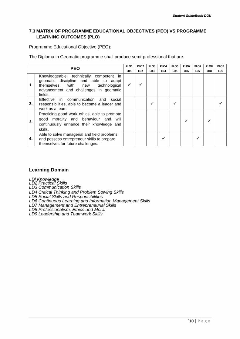
7.3 MATRIX OF PROGRAMME EDUCATIONAL OBJECTIVES (PEO) VS PROGRAMME
LEARNING OUTCOMES (PLO)
Programme Educational Objective (PEO):
The Diploma in Geomatic programme shall produce semi-professional that are:
PEO PLO1 PLO2 PLO3 PLO4 PLO5 PLO6 PLO7 PLO8 PLO9
LD1 LD2 LD3 LD4 LD5 LD6 LD7 LD8 LD9
1.
Knowledgeable, technically competent in geomatic discipline and able to adapt themselves with new technological advancement and challenges in geomatic fields.
2. Effective in communication and social responsibilities, able to become a leader and work as a team.
3.
Practicing good work ethics, able to promote
good morality and behaviour and will
continuously enhance their knowledge and
skills.
4. Able to solve managerial and field problems and possess entrepreneur skills to prepare themselves for future challenges.
Learning Domain
LDl Knowledge LD2 Practical Skills LD3 Communication Skills LD4 Critical Thinking and Problem Solving Skills LD5 Social Skills and Responsibilities LD6 Continuous Learning and Information Management Skills LD7 Management and Entrepreneurial Skills LD8 Professionalism, Ethics and Moral LD9 Leadership and Teamwork Skills
Student GuideBook-DGU
`11 | P a g e
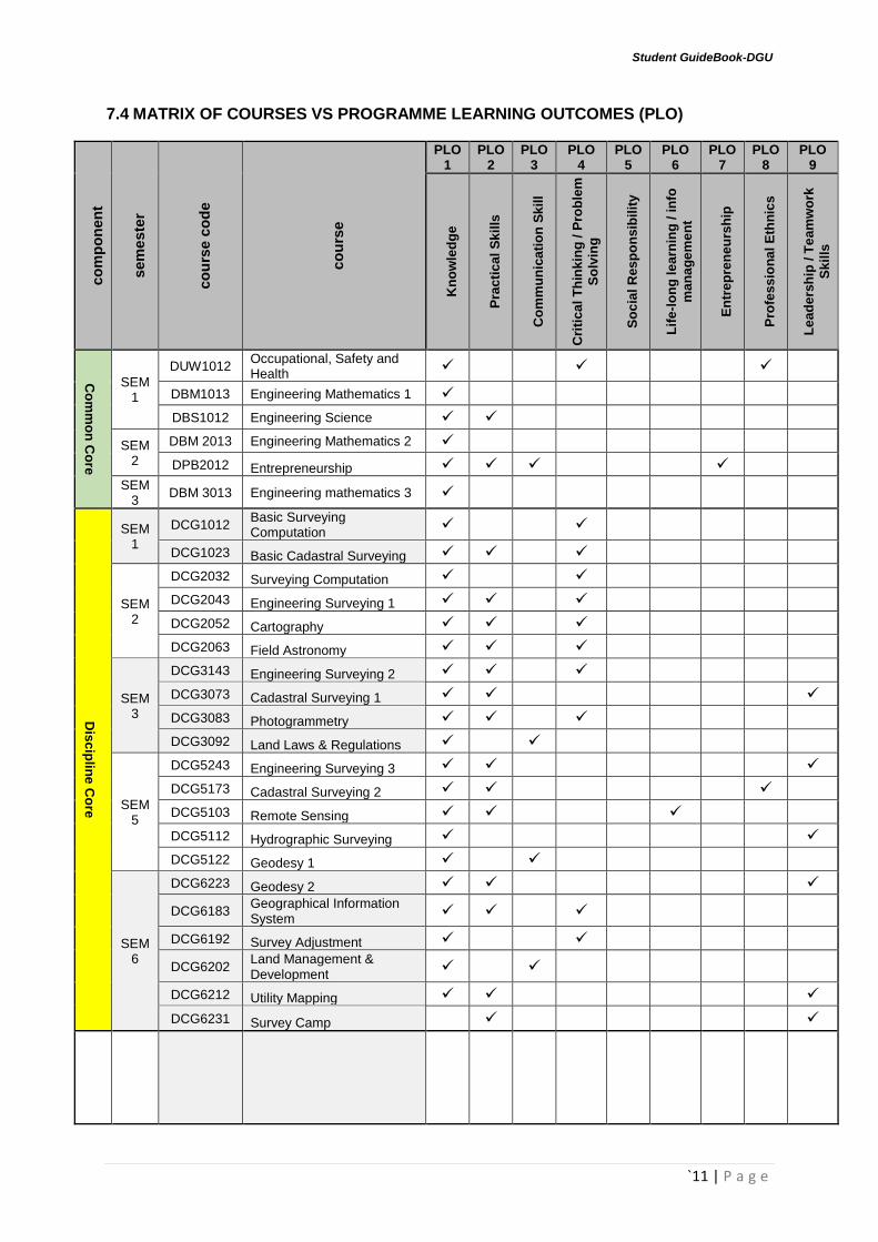
7.4 MATRIX OF COURSES VS PROGRAMME LEARNING OUTCOMES (PLO) co
mp
on
en
t
sem
este
r
co
urs
e c
od
e
co
urs
e
PLO 1
PLO 2
PLO 3
PLO 4
PLO 5
PLO 6
PLO 7
PLO 8
PLO 9
Kn
ow
led
ge
Pra
cti
ca
l S
kil
ls
Co
mm
un
ica
tio
n S
kil
l
Cri
tic
al
Th
ink
ing
/ P
rob
lem
So
lvin
g
So
cia
l R
es
po
nsib
ilit
y
Lif
e-l
on
g l
ea
rnin
g /
in
fo
ma
na
ge
me
nt
En
tre
pre
ne
urs
hip
Pro
fes
sio
na
l E
thn
ics
Le
ad
ers
hip
/ T
ea
mw
ork
Sk
ills
Co
mm
on
Co
re
SEM 1
DUW1012 Occupational, Safety and Health
DBM1013 Engineering Mathematics 1
DBS1012 Engineering Science
SEM 2
DBM 2013 Engineering Mathematics 2
DPB2012 Entrepreneurship SEM
3 DBM 3013 Engineering mathematics 3
Dis
cip
line
Co
re
SEM 1
DCG1012 Basic Surveying Computation
DCG1023 Basic Cadastral Surveying
SEM 2
DCG2032 Surveying Computation
DCG2043 Engineering Surveying 1
DCG2052 Cartography
DCG2063 Field Astronomy
SEM 3
DCG3143 Engineering Surveying 2
DCG3073 Cadastral Surveying 1
DCG3083 Photogrammetry
DCG3092 Land Laws & Regulations
SEM 5
DCG5243 Engineering Surveying 3
DCG5173 Cadastral Surveying 2
DCG5103 Remote Sensing
DCG5112 Hydrographic Surveying
DCG5122 Geodesy 1
SEM 6
DCG6223 Geodesy 2
DCG6183 Geographical Information System
DCG6192 Survey Adjustment
DCG6202 Land Management & Development
DCG6212 Utility Mapping
DCG6231 Survey Camp

Student GuideBook-DGU
`12 | P a g e
Ele
ctiv
e
SEM 6
DCG5132 Visual Basic Programming
DCG5152 Topical Studies
DCG5162 CADD
DBC2012 Computer Application
DUF1XX2 Foreign Languange
DCG6252 Town and Country Planning
DCG6262 Cadastral Surveying in Sarawak & Sabah
Ind
us
trial
train
ing
SEM 4
DUT 40110
Industrial Training

Student GuideBook-DGU
`13 | P a g e
7.5 PROGRAMME STRUCTURE
COMPONENTS COURSE
CODE COURSE
CONTACT HOURS CREDIT
HOURS L P T
SEMESTER 1
Compulsory
DUB1012 Pengajian Malaysia 1 0 2 2
DUE1012 Communicative English 1 1 0 2 2
DRBIXXO Asas Unit Beruniform 0 2 0 0
Common Core
DUW1012 Occupational, Safety and Health 2 0 0 2
DBM1013 Engineering Mathematics 1 2 0 2 3
DBS1012 Engineering Science 2 1 0 2
Discipline Core DCG1012 Basic Surveying Computation 2 0 0 2
DCG1023 Basic Cadastral Surveying 2 3 0 3
Total 22 16
SEMESTER 2
Compulsory
DUA2012 Sains, Teknologi dan Kejuruteraan Dalam Islam * 1 0 2 2
DUB2012 Nilai Masyarakat Malaysia ** 1 0 2 2
DRS2XX1 Sukan 0 2 0 1
DRB2XX1 Unit Beruniform 1 0 2 0 1
Common Core DBM2013 Engineering Mathematics 2 2 0 2 3
DPB2012 Entrepreneurship 2 1 0 2
Discipline Core
DCG2032 Surveying Computation 2 0 0 2
DCG2043 Engineering Surveying 1 2 3 0 3
DCG2052 Cartography 1 2 0 2
DCG2063 Field Astronomy 2 2 0 3
Total 25 18
SEMESTER 3
Compulsory
DUE3012 Communicative English 2 1 0 2 2
DRK3XX2 Ke lab/P ersatuan 0 4 0 2
DRB3XX2 Unit Beruniform 2 0 4 0 2
Common Core DBM3013 Engineering Mathematics 3 2 0 2 3
Discipline Core
DCG3143 Engineering Surveying 2 2 3 0 3
DCG3073 Cadastral Surveying 1 2 3 0 3
DCG3083 Photogrammetry 2 3 0 3
DCG3092 Land Laws & Regulations 2 0 0 2
Total 28 18

Student GuideBook-DGU
`14 | P a g e
COMPONENTS COURSE
CODE COURSE
CONTACT HOURS CREDIT
HOURS L P T
SEMESTER 4
DUT40110 Industrial Training 0 0 0 10
Total 0 10
SEMESTER 5
Compulsory DUE5012 Communicative English 3 1 0 2 2
Discipline Core
DCG5243 Engineering Surveying 3 2 3 0 3
DCG5173 Cadastral Surveying 2 2 3 0 3
DCG5103 Remote Sensing 2 2 0 3
DCG5112 Hydrographic Surveying 2 0 0 2
DCG5122 Geodesy 1 2 0 0 2
Elective
DCG5132 Visual Basic Programming 1 2 0 2
DCG5152 Topical Studies 1 2 0 2
DCG5162 CADD 0 3 0 2
DBC2012 Computer Application 1 2 0 2
DUF1XX2 Foreign Languange 1 0 2 2
Total 24 17
SEMESTER 6
Compulsory DUE3012 Communicative English 2 1 0 2 2
Discipline Core
DCG6223 Geodesy 2 2 3 0 3
DCG6183 Geographical Information System 2 2 0 3
DCG6192 Survey Adjustment 2 0 0 2
DCG6202 Land Management & Development 2 0 0 2
DCG6212 Utility Mapping 1 2 0 2
DCG6231 Survey Camp 0 0 0 1
Elective DCG6252 Town and Country Planning 2 0 0 2
DCG6262 Cadastral Surveying in Sarawak & Sabah 1 3 0 2
Total 28 18
Total Credit %
i. Compulsory 15 16%
ii. Common Core 15 16%
iii. Discipline Core 52 54%
iv. Elective 4 4%
V. Industrial Training 10 10%
TOTAL 96 100%
Student GuideBook-DGU
`15 | P a g e
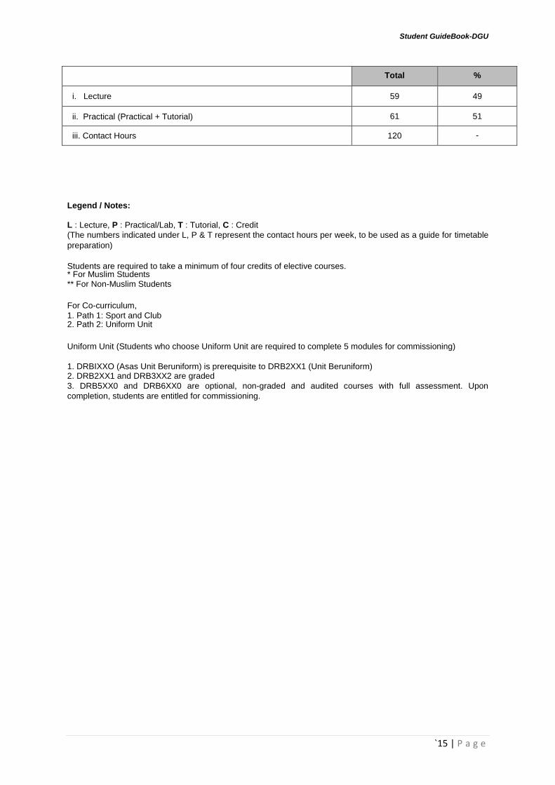
Total %
i. Lecture 59 49
ii. Practical (Practical + Tutorial) 61 51
iii. Contact Hours 120 -
Legend / Notes:
L : Lecture, P : Practical/Lab, T : Tutorial, C : Credit
(The numbers indicated under L, P & T represent the contact hours per week, to be used as a guide for timetable
preparation)
Students are required to take a minimum of four credits of elective courses. * For Muslim Students ** For Non-Muslim Students
For Co-curriculum,
1. Path 1: Sport and Club 2. Path 2: Uniform Unit
Uniform Unit (Students who choose Uniform Unit are required to complete 5 modules for commissioning)
1. DRBIXXO (Asas Unit Beruniform) is prerequisite to DRB2XX1 (Unit Beruniform) 2. DRB2XX1 and DRB3XX2 are graded
3. DRB5XX0 and DRB6XX0 are optional, non-graded and audited courses with full assessment. Upon
completion, students are entitled for commissioning.
Student GuideBook-DGU
`16 | P a g e
7.6 COURSE SYNOPSIS
SEMESTER 1
COURSE SYNOPSIS COURSE LEARNING
OUTCOME (CLO)
DUB1012 PENGAJIAN MALAYSIA
PENGAJIAN MALAYSIA memupuk penghayatan
ke arah melahirkan generasi yang cintakan negara. Kursus ini juga dapat mendidik kelompok masyarakat yang mempunyai daya juang yang tinggi dan mampu menghadapi cabaran di peringkat antarabangsa. Kursus ini memberi penghayatan tentang sejarah dan politik, perlembagaan Malaysia, kemasyarakatan dan perpaduan, pembangunan negara dan isu-isu keprihatinan negara. Objektif kursus ini adalah untuk melahirkan warganegara yang setia dan cintakan negara, berwawasan serta bangga menjadi rakyat Malaysia.
CLO1: Menerangkan dengan baik
sejarahbangsa dan negara. (C2, LD1)
CLO2: Menjelaskan Perlembagaan
Malaysia dan sistem pemerintahan negara. (C2, LD1)
CLO3: Melaksanakan aktiviti
berkaitan kenegaraan ke arah peningkatan patriotisme pelajar. (C3, LD1 :A3,LD6)
DUE1012 COMMUNICATIVE
ENGLISH 1
COMMUNICATIVE ENGLISH 1 focuses on
speaking skills for students to develop the ability to communicate effectively and confidently in group discussions and in a variety of social interactions. It is designed to provide students with appropriate reading skills to comprehend a variety of texts. It is also aimed to equip students with effective presentation skills.
CLO1: Apply appropriate
communication skills in discussions
and conversations. (C3)
CLO2: Comprehend selected texts
using appropriate reading
skills.(C2)
CLO3: Interpret current issues / topic
of interest in written form. (C2)
CLO4: Apply effective presentation
skills.(C3, A3)
DUW1012 OCCUPATIONAL,
SAFETY AND HEALTH
OCCUPATIONAL SAFETY AND HEALTH course
is designed to impart understanding of the self-regulatory concepts and provisions under the Occupational Safety & Health Act (OSHA). This course presents the responsibilities of employers and employees in implementing and complying with the safety procedures at work. This course provide an understanding of the key issues in OSH management, incident prevention, Emergency Preparedness and Response (EPR), fire safety, occupational first aid, Hazard Identification, Risk Assessment and Risk Control (HIRARC) and guide the students gradually into this multi-disciplinary science.
CLO1: Identify the OSH legislation
and its compliance in Malaysia.
(C2, LD1)
CLO2: Explain briefly incident
hazards, risks and safe work
practices in order to maintain health
and safe work environment. (C2,
LD1)
CLO3: Discuss cooperatively in
responding to an accident action at
workplace. (C3,LD1; A2,LD4)
CLO4: Adhere to the safety
procedures in respective fields. (A3,
LD8)
DBM1013 – ENGINEERING
MATHEMATICS 1
ENGINEERING MATHEMATICS 1 expose
students to the basic algebra including perform partial fractions. This course also exposes the concept of trigonometry and the method to solve trigonometry problems by using basic identities, compound angle and double angle formulae. Students also will be introduced to the theory of complex number and matrices method to solve simultaneous equation. This course also introduces students to concept of vector and scalar.
CLO1: Identify mathematical methods
in solving the mathematical
problems. (C2, LD1)
CLO2: Solve the mathematical
problems by using appropriate
techniques and solutions. (C3, LD1)
CLO3: Practice mathematical
knowledge and skills in different
mathematics problem. (C3, LD1)
DBS1012 – ENGINEERING
SCIENCE
ENGINEERING SCIENCE is an applied science
with theoretical concepts and practical learning sessions that can be applied in the engineering fields. This course focuses on the Physical Quantities, Measurement, Linear Motion, Force, Work, Energy, Power, Solid, Fluid, Temperature and Heat.
CLO1: Solve the basic engineering
science problems by using related concept. (C3, LD1)
CLO2: Organise an appropriate
experiments to prove related physic principles. (P3, LD2)
CLO3 Apply related physic principles
Student GuideBook-DGU
`17 | P a g e
in various situations to enhance knowledge. (C3, LD1)
DCG1023 – BASIC
CADASTRAL SURVEYING
BASIC CADASTRAL SURVEYING provides
students with the knowledge and understanding of the cadastral system in Malaysia and functions of related land agencies. Students are also exposed to cadastral equipment test/calibration and cadastral field work procedures according to Cadastral Survey Regulation and Circulars issued by the Department of Survey and Mapping Malaysia (JUPEM).
CLO1: explain the concept of
cadastral survey and functions of related land and survey agencies according to individual government department. (C2,PLO1)
CLO2: apply the concept of total
station operation, datum selection and cadastral traverse according to Cadastral Survey Regulation. (C3, PLO1)
CLO3: conduct total station setting
up, differential field test, calibration and closed traverse according to Cadastral Survey Regulation. (P4, PLO2)
CLO4: demonstrate the ability to
solve datum selection according to Cadastral Survey Regulation. (A3,PLO4)
DCG1012 – BASIC
SURVEYING COMPUTATION
BASIC SURVEYING COMPUTATION equips
students with knowledge and understanding in
problem solving related to the calculations of field
survey.
CLO1: Calculate angle measurement
and surveying triangles by using related methods. (C3, PLO1)
CLO2: apply traverse adjustment to
generate final coordinates by using related formula. (C3,PLO1)
CLO3: demonstrate the ability to
solve triangle, height and distance problems using trigonometrical concept . (A3,PLO4)
DRB1012 – ASAS UNIT
BERUNIFORM
Memfokuskan kepada penguasaan pengetahuan
dan kemahiran khusus secara holistik bagi
mengukuhkan pembentukan kemahiran insaniah
pelajar yang positif.
CLO1: Menunjukkan kemahiran
khusus yang dipelajari. (P2: LD2).
CLO2: Melaksanakan aktiviti-aktiviti
berdasarkan penguasaan kemahiran yang dipelajari. (A2 : LD4, LD9)
SEMESTER 2
COURSE SYNOPSIS COURSE LEARNING
OUTCOME (CLO)
DUA2012 SAINS
TEKNOLOGI DAN KEJURUTERAAN
DALAM ISLAM
SAINS, TEKNOLOGI DAN KEJURUTERAAN DALAM ISLAM memberi pengetahuan tentang
konsep Islam sebagai al-Din dan seterusnya membincangkan konsep sains, teknologi dan kejuruteraan dalam Islam serta impaknya, pencapaiannya dalam tamadun Islam, prinsip serta peranan syariah dan etika Islam, peranan kaedah fiqh serta aplikasinya.
CLO1: Menghuraikan konsep Islam
sebagai cara hidup. (C2, LD1 : P2, LD2)
CLO2: Menjelaskan konsep sains,
teknologi dan kejuruteraan dalam Islam. (C2, LD1)
CLO3: Membincangkan prinsip
syariah dan kaedah fiqh dalam sains, teknologi dan kejuruteraan. (C3, LD1 : A3, LD6)
DUB2012 NILAI
MASYARAKAT MALAYSIA
NILAI MASYARAKAT MALAYSIA
membincangkan aspek sejarah pembentukan masyarakat Malaysia, nilai-nilai agama serta adat resam dan budaya masyarakat majmuk. Selain itu, pelajar diberi kefahaman mengenai tanggungjawab individu dalam kehidupan dan cabaran-cabaran dalam membangunkan masyarakat Malaysia.
CLO1: Menerangkan sejarah
pembentukan masyarakat dan nilai agama di Malaysia. (C2 : LD1)
CLO2: Menghubung kait
tanggungjawab individu dalam kehidupan masyarakat dan negara. (C3 : LD1, A2 : LD5)
CLO3: Membincangkan cabaran-
cabaran dalam membangunkan
Student GuideBook-DGU
`18 | P a g e
masyarakat Malaysia. (C3 : LD1, A3 : LD6)
DBM2013 ENGINEERING
MATHEMATICS 2
ENGINEERING MATHEMATICS 2 exposes
students to the basic laws of exponents and logarithms. This course also introduces the basic rules of differentiation concept to solve problems that relate maximum, minimum and calculate the rates of changes. This course also discuss integration concept in order to strengthen student knowledge for solving area and volume bounded region problems. In addition, students also will learn application of both techniques of differentiation and integration.
CLO1: Solve the mathematical
problems by using appropriate mathematical techniques and solutions. (C3, LD1)
CLO2: Show the solution for
differentiation and integration problem by using appropriate method.(C3, LD1)
CLO3: Practice mathematical
knowledge and skills in different mathematics problem. (C3, LD1)
DCG2043 ENGINEERING SURVEYING 1
ENGINEERING SURVEYING 1 provides basic
knowledge in engineering surveying. The course emphasizes on angle and distance measurement, leveling, area and volume works. It also provides early exposure to students in practical work.
CLO1: apply the knowledge of basic
land survey and its calculation in engineering surveying. (C3, PLO1)2.
CLO2: perform perimeter survey and
leveling works using related survey equipment according to survey regulation. (P4, PLO2)
CLO3: demonstrate good
communication skill in presentation individually or in group within stipulated time frame (A3, PLO3)
DCG2032 SURVEYING
COMPUTATION
SURVEYING COMPUTATION equips students
with knowledge in problem solving related to
boundaries and land division such as in title
survey which include calculation of missing data,
three points and distance in field work.
CLO1: explain the concept of basic
least square adjustments. (C2, PLO1)
CLO2: apply the concept of field
problems solution and trigonometry to solve boundaries and sub-division problems. (C3, PLO1)
CLO3: demonstrate the ability to
solve three points and distances problem by using related formula. (A3, PLO4)
DCG2025 CARTOGRAPHY
CARTOGRAPHY provides students with the
knowledge on concept and basic principles on
generating the map. The course provides the
effect related to the map processing from the
basic information aspect, collecting process and
graphic info arrangement and also the production
of map. This course exposes the students to the
knowledge on how the map is being published the
conventional method and new technology
CLO1: apply cartographical concept
and methods used in mapping according to standard procedure. (C3,PLO1)
CLO2: manipulate appropriate
techniques to produce map by using digital cartography. (P4,PLO2)
CLO3: Demonstrate the ability to
solve related problems in cartographic equipment and software by using standard procedure. (A3,PLO4)
DCG2063 FIELD
ASTRONOMY
FIELD ASTRONOMY equips students with
knowledge on the position of celestial bodies such
as the moon, sun, stars and planets with
reference to earth. This study is important to land
surveyors in field works such as determining the
azimuth in land boundaries, checking angles in
long traverse and determining geodetic positions
or geographic points on earth.
CLO1: apply astronomical and
falak syarie concept according to Department of Survey and Mapping Malaysia (JUPEM) and Department of Islamic Development Malaysia (JAKIM) using related formula. (C3,PLO1)
CLO2: conduct solar observation
for azimuth verification using extra meridian method. (P4,PLO2)
CLO3: demonstrate the ability to
solve qiblah direction and prayer time using related
Student GuideBook-DGU
`19 | P a g e
formula. (A3,PLO4)
DRS2001 SUKAN
SUKAN memfokuskan kepada penguasaan
pengetahuan dan kemahiran khusus secara
holistik bagi mengukuhkan pembentukan
kemahiran insaniah pelajar yang positif.
CLO1: Mempamerkan kompetensi
kemahiran khusus yang dipelajari.
(PLO4)
CLO2: Bekerjasama menganjurkan
aktiviti berdasarkan penguasaan kemahiran yang dipelajari.
DRB2001 UNIT
BERUNIFORM 1
UNIT BERUNIFORM 1 memfokuskan kepada
penguasaan pengetahuan dan kemahiran khusus
secara holistik bagi mengukuhkan pembentukan
kemahiran insaniah pelajar yang positif.
CLO1: Mempamerkan kompetensi
kemahiran khusus yang dipelajari. (PLO4)
CLO2: Bekerjasama menganjurkan
aktiviti berdasarkan penguasaan kemahiran yang dipelajari.
DPB2012 ENTREPRENEURSHIP
ENTREPRENEURSHIP focuses the principles
and concept of entrepreneurship. This course
concentrates on the systematic methods of getting
business ideas. This course also prepares the
students on ways to conduct and control the
business including fundamental of management,
marketing and financing. It also emphasizes on
the preparation of business plan, thus developing
their entrepreneurial skills.
CLO1: Explain clearly the concept of
entrepreneurship, process and procedures involved in developing effective business plan. (C2, LD1)
CLO2: Work cooperatively in group to
complete the assigned project based on entrepreneurial skills. (P3, LD2) (A3, LD7)
CLO3: Present business plan
creatively using knowledge gained via group. (A2, LD3)
SEMESTER 3
COURSE SYNOPSIS COURSE LEARNING
OUTCOME (CLO)
DUE3012 COMMUNICATIVE
ENGLISH 2
COMMUNICATIVE ENGLISH 2 emphasises the
skills required at the workplace to describe products or services as well as processes or procedures. It also focuses on the skills to give and respond to instructions. This course will also enable students to make and reply to enquiries and complaints.
CLO1: Describe products or services
related to their field of studies using appropriate language. (C3, A3)
CLO2: Transfer information on
processes or procedures using appropriate language from non-linear to linear form. (C3)
CLO3: listen and respond to
enquiries using appropriate language.(C3)
CLO4: make and respond to
complaints using appropriate language.(C3)
DRK3002 KELAB /
PERSATUAN
** Merujuk silibus asas unit beruniform yang ditawarkan mengikut Politeknik.
CLO1: Mempamerkan kompentensi
kemahiran khusus yang dipelajari. (P3: LD2)
CLO2: Mengorganisasikan aktiviti
berdasarkan kemahiran-kemahiran yang dipelajari. (A3: LD4, LD9)
DRB3002 UNIT
BERUNIFORM 2
** Merujuk silibus asas unit beruniform yang ditawarkan mengikut Politeknik.
CLO1: Mempamerkan penguasaan
kemahiran insaniah yang dipelajari di dalam aktiviti. (P3 : LD2)
CLO2: Mengaplikasikan aktiviti-
aktiviti berdasarkan penguasaan kemahiran yang dipelajari. (A3 : LD4, LD9)
DBM3013 ENGINEERING
MATHEMATICS 3
ENGINEERING MATHEMATICS 3 exposes
students to the statistical and probability
concepts and their applications in
CLO1: solve the mathematical
problems by using
appropriate techniques and

Student GuideBook-DGU
`20 | P a g e
interpreting data. The course also
introduces numerical methods concept to
solve simultaneous equations by using
Gaussian Elimination method, LU
Decomposition using Doolittle and
Crout methods, polynomial problems using
Simple Fixed Point Iteration and Newton-
Raphson methods. In additional, the course
also discusses optimization problems by
using Linear Programming. In order to
strengthen the students in solving advanced
engineering problems, Ordinary Differential
Equation (ODE) is also included.
solutions.(C3, LD1)
CLO2: Show the solution for
statistics and probability
problems, and linear
programming by using
appropriate mathematical
methods. (C3, LD1).
CLO3: Practice mathematical
knowledge and skills in
different mathematical
problem. (C3, LD1)
DCG3143 ENGINEERING SURVEYING 2
ENGINEERING SURVEYING 2 provides
knowledge on Topographic survey,
automation survey, calculation of volume
using Mass Haul Diagram and concept
Global Positioning System (GPS). It also
emphasizes on detail surveying and GPS
field work.
CLO1: apply the concept of
topographic surveys, automation survey, positioning and earthwork volume. (C2, PLO1)
CLO2: Calculate the earthwork
volume by using Mass Haul Diagram. (C3, PLO1)
CLO3: Perform topographic and
positioning survey work by using Total Station and Global Navigation Satellite System (GNSS) equipment. (P4, PLO2) demonstrate the ability to produce topographic, longitudinal and cross section plan by automation software. (A3, PLO4)
DCG3073 CADASTRAL SURVEYING 1
CADASTRAL SURVEYING 1 provides
students with the knowledge on title survey,
land development process and exposure to
conduct cadastral works according to the latest
regulations. It also emphasizes on problem
solving and techniques of collecting data
manually and Field To Finish (F2F) concept
until the production of Certified Plan (CP).
CLO1: Apply the concept of
cadastral survey work and land developments according to Cadastral Survey Regulation and National Land Code. (C3,PLO1)
CLO2: Perform cadastral work with
F2F concept according to the Department of Survey and Mapping Malaysia (JUPEM) or Department of Land and Survey Sarawak (JTSS) or Department of Land and Survey Sabah (JTUS) format. (P4,PLO2)
CLO3: Demonstrate the ability to
lead and work as a team to complete astronomical observation in cadastral work manually according to Cadastral Survey Regulation. (A3,PLO9)
DCG3092 LAND LAWS AND
REGULATIONS
LAND LAWS AND REGULATIONS provides
exposure and knowledge related to the
legislative system which was used in land
administration in Peninsular Malaysia before
and after the introduction of the National Land
Code and also the land administration system
for Sabah and Sarawak. This course also
explains land disposals, land dealing and
transactions, Malay Reserve, Sabah and
Sarawak Land Reserve and land acquisition by
the State Authority. This knowledge is important
in order to solve any problems related to land
administration and management.
CLO1: Explain the National Land
Code in Peninsular Malaysia and land administration in Sabah and Sarawak. (C2, PLO1)
CLO2: apply the concept of
Malay reserve in Peninsular Malaysia, land reserve in Sabah and Sarawak and land acquisition under Land Acquisition Act 1960 (Act 486). (C3,PLO1)
CLO3: Demonstrate good
communication skill in presentation individually / in group, on assigned topic(s)

Student GuideBook-DGU
`21 | P a g e
within a stipulated time frame. (A3, PLO3)
DCG3083 PHOTOGRAMMETRY
PHOTOGRAMMETRY equips students with
knowledge regarding the principles, methods and
equipment for aerial survey works. It is important
to surveyor in solving problems related to aerial
surveys. It also explains the principles and
methods in conducting digital stereo mapping.
CLO1: Apply basic principles and
concept in photogrammetry elements. (C3,PLO1)
CLO2: Display appropriate
techniques to conduct the stereoscopic viewing and digital photogrammetry. (P4, PLO2)
CLO3: Demonstrate the ability to
solve problems related to geometry aerial photo and flight planning. (A3, PLO4)
SEMESTER 4
COURSE SYNOPSIS COURSE LEARNING
OUTCOME (CLO)
DUE5012 COMMUNICATIVE
ENGLISH 3
COMMUNICATIVE ENGLISH 3 aims to develop
the necessary skills in students to carry out a mini project as well as job hunting. Students will learn to present ideas through the use of graphs and charts. Students will learn the process of job hunting which includes job search strategies and making enquiries. They will also learn to write resumes and cover letters. The students will develop skills to introduce themselves, highlight their strengths and abilities, present ideas, express opinions and respond appropriately during job interviews.
CLO1. Describe information
contained in graphs and charts effectively. (C4, A3)
CLO2. Apply job hunting mechanics
appropriately. (C3) CLO3. Respond to interview
questions using appropriate language when applying for jobs. (C3)
DCG5243 ENGINEERING SURVEYING 3
ENGINEERING SURVEYING 3 provides
knowledge on principles of engineering survey. The course emphasizes on the construction survey work, setting out in construction, curve alignment, monitoring survey and dimensional survey. It also exposes students to field works.
CLO1: apply the principles of
engineering survey works correctly according to the latest standard (C3,PLO1)
CLO2: Perform setting out, as-built
survey and curve alignment in engineering works according to the latest standard. (P4,PLO2)
CLO3: Demonstrate the ability to
lead and work as a team in presenting final reports on monitoring survey. (A3,PLO9)
DCG5173 CADASTRAL SURVEYING 2
CADASTRAL SURVEYING 2 provides students
with the knowledge on cadastral system and
cadastral electronic services. It emphasizes on
the usage of Global Navigation Satellites System
(GNSS) equipment for cadastral work via post
processing and MyRTKnet environment.
Besides, students are also exposed to strata,
stratum title and professional practice as
licensed surveyor.
CLO1: Apply the concept of several
cadastral modules and professional bodies related to cadastral works according to Cadastral Survey Regulation and Licensed Land Surveyors Act 1958 (Amended 2011). (C3,PLO1)
CLO2: Perform GNSS equipment
test/calibration, cadastral survey work by post process and MyRTKnet method and strata title work according to Cadastral Survey Regulation. (C3,PLO2)
CLO3: Demonstrate code of
professional conduct of Licensed Land Surveyors according to License Land Surveyor Act 1958 (Amended 2011). (A3,PLO8)
Student GuideBook-DGU
`22 | P a g e
CLO4: Present business plan
creatively using knowledge gained related to any land development in groups. (A2,PLO7)
DCG5103 REMOTE SENSING
REMOTE SENSING equips students with the
knowledge of imagery concept. This course
explains the concept of data capture from
electromagnetic energy recording, by sensors
brought by airplane or satellite. This course also
develops student’s skills in using software for
digital image processing, digital image
enhancement and image classification.
CLO1: Explain of the appropriate
principles and theories to explain
the concept of remote sensing.
(C3, PLO1)
CLO2: Perform image enhancement,
image classification and map
annotation using any computer
software accurately (P4,PLO2)
CLO3: Demonstrate the ability to
show geometric correction and
image enhancement using any
computer software (A3,PLO6)
DCG5122 HYDROGRAPHIC
SURVEYING
HYDROGRAPHIC SURVEYING provide
students with the fundamental knowledge in
hydrographic survey including the theory of
tides, hydrographical survey planning, and
techniques for positioning, sounding and charts
production process.
CLO1: Explain the concept of
hydrographic survey, function of hydrographic agencies, planning procedures, sounding and plans production process. (C2,PLO1)
CLO2: Apply the concept of datum
transfer, positioning and reduction of echo trace according to hydrographic standard. (C3,PLO1)
CLO3: Demonstrate the ability to lead
and work as a team in applying the most appropriate methods of positioning and sounding in hydrographic survey complying to the requirements of the clients and survey planning. (A3,PLO9)
DCG5122 GEODESY 1
GEODESY 1 introduces students to the field
related with geodesy and provides knowledge of
the reference surface in geodesy, ellipsoidal
geometry characteristics, datum in geodesy,
geodesy coordinate system and computation on
an ellipsoids
CLO1: Explain the geodetic concept
in land surveying field. (C2,PLO1) CLO2: Apply the calculation to obtain
the required data in Geodesy. (C3,PLO1)
CLO3: Demonstrate good
communication skill in oral presentation in group on assigned topic within as stipulated time frame. (A3,PLO3)
DCG5162 CADD for
SURVEYOR
Computer Aided Design and Drafting for
SURVEYORS (CADD) provides students with
the knowledge and skill in producing cadastral
and engineering survey plans with AutoCAD and
relevant survey software according to a standard
format.
CLO1: Apply technical knowledge
and specific command in CADD software. (C3,PLO1)
CLO2: Perform appropriate technique
to download survey data for the production of cadastral and engineering plan according to standard format. (P4,PLO2)
CLO3: Demonstrate related design
skills in CADD to produce cadastral and engineering plans. (A3,PLO4)
Student GuideBook-DGU
`23 | P a g e
SEMESTER 5
COURSE SYNOPSIS COURSE LEARNING
OUTCOME (CLO)
DUA6022 KOMUNIKASI DAN PENYIARAN ISLAM
KOMUNIKASI DAN PENYIARAN ISLAM
memfokuskan kepada penguasaan konsep, kemahiran komunikasi dan penyiaran Islam bagi meningkatkan kefahaman pelajar secara holistik terhadap kursus ini.
CLO1: Menjelaskan konsep
komunikasi dan penyiaran dalam Islam. (C2 : LD1)
CLO2: Menghubung kait isu-isu
semasa dalam komunikasi Islam. (C3, A4 : LD1, LD5)
CLO3: Menunjukkan kemahiran
pengurusan dakwah dalam bidang penyiaran Islam. (C3, A3 : LD1, LD6)
DCG6223 GEODESY 2
GEODESY 2 introduces students to gravity
measurement and gravity data reduction on ellipsoid, precise levelling, GPS levelling method, height system in geodesy, up-to-date development of Malaysia geodetic network and positioning with GPS.
CLO1: Explain the geodetic survey
work in Malaysia. (C3,PLO1)
CLO2: Perform actively to conduct
the control network in geodetic survey.(P4,PLO2)
CLO3: Demonstrate ability to work in
team to complete assigned tasks during practical work sessions. (A3,PLO9)
DCG6138 GEOGRAPHICAL INFORMATION SYSTEM (GIS)
GEOGRAPHICAL INFORMATION SYSTEM (GIS) emphasizes the utilization of computer
software, databases, and survey technology via hands-on exercises in field data collection, input, conversion, analysis, map output and multimedia presentation. The knowledge and skills gained in these studies can be applied to work in various industrial sectors, including surveying, mapping, local and regional government, forestry, agriculture, town planning, military, health, business, education and the environment.
CLO1: Apply the concepts of GIS to
develop Geographic Information System.(C3,PLO1)
CLO2: Manipulate the technique of
spatial analysis and GIS applications in various areas. (P4,PLO2)
CLO3: Solve the problem by using
appropriate technique in GIS software. (A5,PLO4)
DCG6192 SURVEY
ADJUSTMENT
SURVEY ADJUSTMENTS provides the
students with knowledge on adjustment. The course emphasizes the calculation of adjustment using the least square adjustment method by means of observation and condition equations in solving surveyed data. Besides, it’s also provides students with knowledge and practical skills to calculate and adjust surveyed data.
CLO1: Explain the concept and
principle of statistical sample and variance-covariance propagation in survey adjustment.(C2, PLO1)
CLO2: Apply the least square
adjustment in land survey data.(C3,PLO1)
CLO3: Demonstrate good critical
thinking and problem solving individually in classes during discussion sessions.(A3,PLO4)
DCG6202 LAND
MANAGEMENT AND
DEVELOPMENT
LAND MANAGEMENT AND DEVELOPMENT
provides students with the exposure and knowledge related to land management and development in Malaysia. The module emphasizes on the land management and development under Strata Title Act 1985, nunderground land development, mining land development, land development under Group Settlement Area (GSA) and land development under National Land Code (NLC) 1965. Students are also exposed to planning aspects under Town and Country Planning Act 1976 (Act 172) and also Local Authority Act 1976 (Act 171).
CLO1: Explain the definition, concept
and process of vertical development (strata), underground land development (stratum) correctly. (C2, PLO1)
CLO2: Relate the land development
based on Mineral Development Act 1994 and State Mineral Enactment, Group Settlement Area Act 1960 and National Land Code 1965 , Town and Country Planning Act 1976 specifically. (C3, PLO1)
CLO3: Demonstrate good
communication skills in presentation individually or in group on assign topic within stipulated time frame. (A3, PLO3)

Student GuideBook-DGU
`24 | P a g e
DCG6212 UTILITY MAPPING
UTILITY MAPPING exposes the students to
the definition, history, objectives, scope, method of survey, occupational safety and health, processing and mapping of underground utility mapping. These topics provide the student of the knowledge of field work such as determining the positions of underground materials on earth surface.
CLO1: Describe the history, utility
quality level attributes of utility mapping, mapping utilities data and instruments used in underground detection survey precisely.(C2,PLO1)
CLO2: Explain the method of survey
for utility, occupational safety and health and processing utilities data. (C4,PLO1)
CLO3: Conduct a control survey and
utility mapping, processing of control and detail survey for utility mapping and utilities data collecting by different underground detection survey instruments (P4,PLO2)
DCG5132 VISUAL BASIC
PROGRAMMING
VISUAL BASIC PROGRAMMING provides
students with knowledge of the programming concepts using the visual basic programming language. The course emphasizes on design the programme which includes examining code, looping statement and also creates and document naming standard.
CLO1: Apply the concepts of visual
basic programming to develop a standalone application programmes.(C3, PLO1)
CLO2: builds a programme using the
visual basic language.(C3,PLO1) CLO3: Demonstrate related design
skills in visual basic language. (A3,PLO4)
DCG6231 SURVEY CAMP
SURVEY CAMP provides students with the
knowledge and generates skill in the field of land and hydrographic surveys especially on measurement and positioning technique, data processing and plan presentation. This course puts emphasizes on the cadastral survey, engineering survey, GPS survey and hydrographic survey. It also exposes the students with team work in completing the tasks assigned during the survey camp.
CLO1: Complete the survey task
during the engineering survey camp successfully and presenting engineering survey camp report satisfactorily.(P3,PLO2)
CLO2: Perform control survey,
cadastral and setting out survey works. Students also perform Global Positioning System (GPS) survey, hydrographic survey, and automation survey appropriately according to Department of Survey and Mapping Malaysia (JUPEM) and license surveyor. (P4, PLO2)
CLO3: Demonstrate the ability to lead
and work as a team to complete the task given according to JUPEM and License Surveyor standard. (A3,PLO9)
SEMESTER 6
COURSE SYNOPSIS COURSE LEARNING
OUTCOME (CLO)
DUT 40110
INDUSTRIAL TRAINING exposes students to
related workplace competencies demanded by
industries. This course provides exposure to students
in terms of technology literacy, effective
communication, practice social skills and teamwork,
policies, procedures and regulations, professional
ethics and reporting. It also equips students with real
work experience, thus helping students to perform as
novice workers.
CLO1: Apply related knowledge and
skills at the workplace. (C3, P2)
CLO2: Communicate effectively with
others. (A3)
CLO3: Practice teamwork. (A5)
CLO4: Professionally and ethically
comply with policies, procedures and
rules of the organization. (A5)
CLO5: Explain the tasks assigned
(during the industrial training)
according to the prescribed format.
(P2, A4)