Embed Size (px)
Citation preview
1
TABLE OF CONTENTS
LIST OF ACRONYMS ............................................................................................................ 31.0 INTRODUCTION .......................................................................................................... 4
1.1 Background ........................................................................................................ 41.2 Project Authority ................................................................................................ 5
2.0 PURPOSE AND NEED .................................................................................................. 63.0 ALTERNATIVES ANALYSIS ...................................................................................... 7
3.1 Alternatives Considered and Dismissed .............................................................. 73.1.1 Repair to Pre-Disaster Conditions ............................................................ 73.1.2 Fort Pierce City Marina and Storm Protection System ConceptualDesign 73.1.3 Fort Pierce City Marina and Alternative Storm Protection SystemConceptual Design .............................................................................................. 83.1.4 Vertical Wall with Riprap ........................................................................... 9
3.2 No Action Alternative .......................................................................................103.3 Proposed Alternative .........................................................................................10
4.0 AFFECTED ENVIRONMENT AND ENVIRONMENTAL CONSEQUENCES .......134.1 Summary of Impacts and Mitigation .................................................................134.2 Water Resources ...............................................................................................21
4.2.1 Surface Water and Water Quality ............................................................214.2.2 Floodplains .............................................................................................264.2.3 Wetlands.................................................................................................28
4.3 Coastal Resources .............................................................................................284.3.1. Coastal Zone Management Act ...............................................................284.3.2 Coastal Barrier Resource Act ..................................................................294.3.3 Navigation Impacts .................................................................................29
4.4 Biological Resources .........................................................................................304.4.1 Terrestrial Environment ..........................................................................304.4.2 Aquatic Environment ..............................................................................304.4.3 Essential Fish Habitat .............................................................................334.4.4 Threatened and Endangered Species .......................................................37
4.5 Socioeconomic Issues ........................................................................................414.5.1 Socioeconomic Impacts ..........................................................................414.5.2 Recreational Impacts...............................................................................434.5.3 Environmental Justice .............................................................................44
4.6 Air and Noise Impacts .......................................................................................454.6.1 Air Quality .............................................................................................454.6.2 Noise Impacts .........................................................................................45
4.7 Cultural Resources ............................................................................................464.7.1 Historic Resources ..................................................................................474.7.2 Archaeological Resources .......................................................................47
4.8 Safety ................................................................................................................48
2
4.8.1 Health and Safety....................................................................................484.8.2 Executive Order 13045 ...........................................................................494.8.3 Americans with Disabilities Act ..............................................................50
4.9 Public Services and Utilities ..............................................................................504.10 Cumulative and Secondary Impacts ...................................................................50
4.10.1 Cumulative Impacts ................................................................................514.10.2 Secondary Impacts ..................................................................................51
5.0 PUBLIC INVOLVEMENT ...........................................................................................54
6.0 AGENCY COORDINATION AND PERMITS ...........................................................566.1 Agency Coordination ........................................................................................566.2 Permits and Conditions......................................................................................58
7.0 CONCLUSIONS ............................................................................................................61
8.0 REFERENCES ..............................................................................................................639.0 LIST OF PREPARERS .................................................................................................66
Appendix A ExhibitsExhibit 1 Project Location MapExhibit 2 U.S.G.S. Topographic Map of Project AreaExhibit 3 Ft. Pierce and Nearest Public MarinasExhibit 4 Overall Plan View of Proposed Marina and Storm
Protection SystemExhibit 5 Plan View of Habitats Provided by Storm Protection
IslandExhibit 6 Plan View of Habitats Provided by Tombolo PointExhibits 7a/7b Plan View of Habitats Provided by Free Form
Breakwater Habitat IslandsExhibit 8a/8b Flood Insurance Rate Map, Ft. Pierce Flood Zones;
Zone TableExhibit 9 National Wetland Inventory Map, Ft. Pierce Area
WetlandsExhibit 10 Plan View of Existing Seagrass BedsExhibit 11a Plan View of Seagrass Impact Areas, Storm Protection
IslandExhibit 11b Plan View of Seagrass Impact Areas, Free Form
Breakwater Habitat IslandsExhibit 12 Plan View of Proposed Seagrass Recruitment Areas
Appendix B Agency Correspondence and Consultation Letters
Appendix C Public Notices and Public Participation
3
LIST OF ACRONYMS
BMPs - Best Management PracticesCBRA - Coastal Barrier Resource ActCCCL - Coastal Construction Control LineCEQ - Council on Environmental QualityCFR - Code of Federal RegulationsCZMA - Coastal Zone Management ActCZMP - Coastal Zone Management PlandBA - decibels, “A-weighted”EA - Environmental AssessmentEFH – essential fish habitatEIS - Environmental Impact StatementEO - Executive OrderEO 11988 - FloodplainEO 11990 - WetlandsEO 12898 - Environmental JusticeEO 13045 - Protection of ChildrenESA - Endangered Species ActFEMA - Federal Emergency Management AgencyFIRM - Flood Insurance Rate MapFL DEP - Florida Department of Environmental ProtectionFONSI - Finding of No Significant ImpactFWCC - Florida Fish and Wildlife Conservation CommissionMLW - mean low waterMWL – mean water levelNAAQS - National Ambient Air Quality StandardsNEPA - National Environmental Policy ActNMFS – National Marine Fisheries ServiceNOAA - National Oceanic and Atmospheric Administration’s National Marine FisheriesNTU - nephelometric turbidity unitNWI - National Wetland InventoryPA - Public AssistancePAHs –polycyclic aromatic hydrocarbonsPW - Project WorksheetSection 10 Permit – Rivers and Harbors Act Work in Navigable Waters PermitSection 404 Permit - Clean Water Act Dredge and Fill PermitSHPO - State Historic Preservation OfficerSSE - south-southeastUSACE - U.S. Army Corps of EngineersUSEPA - U.S. Environmental Protection AgencyUSFWS - U.S. Fish and Wildlife Service
4
1.0 INTRODUCTION
1.1 Background
Hurricane Frances formed in the Southern Atlantic on August 25, 2004; it strengthened to aCategory 4 hurricane on August 31, 2004 and made its initial landfall on south HutchinsonIsland on September 5, 2004 as a Category 2 hurricane. After landfall, Frances turnednortheast back into the Gulf of Mexico. Hurricane Frances then moved northwestwardthrough the Gulf of Mexico and made a final landfall near the Florida Big Bend region onSeptember 6, 2004. In anticipation of landfall, President George W. Bush issued a majordisaster declaration (FEMA-1545-DR-FL) in conformance with the Robert T. StaffordDisaster Relief and Emergency, as amended by Public Law 106-390, the Disaster MitigationAct of 2000 on September 4, 2004. As a result, the entire State of Florida was declaredeligible for Public Assistance (PA) Categories A and B work, and 52 counties were declaredeligible for PA categories C-G work, including St. Lucie County.
The City of Fort Pierce has applied to the Federal Emergency Management Agency (FEMA)for assistance with repairs to their City Marina and installation of a Storm Protection Systemwithin the Indian River Lagoon for hazard mitigation. The Fort Pierce City Marina is a publicmarina located on the downtown waterfront in the City of Fort Pierce, Florida. It is locatedon the western shore of the Indian River Lagoon in St. Lucie County, at latitude 27.4508o,longitude -80.3218o. The project location is shown in Appendix A - Exhibits 1 and 2.
As a result of Hurricane Frances, the City of Fort Pierce’s marina was severely damaged. Theouter harbor area was completely destroyed; docks near the entrance to the inner harbor wereseverely damaged. Docks at the outer harbor were destroyed when the hurricane causedfailure of the concrete pilings anchoring the floating docks. Boats were sunk or destroyed inboth the outer and inner harbors. In all, 150 public marina slips were lost and 69 boats weresunk or destroyed.
It is unclear which force(s) caused the most damage. Because the storm stalled and hurricaneforce winds lasted for 32 hours, water levels were high and currents within the vicinity werereported to be as high as 10-12 knots. The outer piles of the docks were bent by the forces,and the inner piles broke off approximately six feet from the river bottom. The loss of the 69vessels and damage to an additional 27 boats from this storm event totaled approximately$26 million; the loss of the marina was an additional $15.5 million. Damage to the docks wascaused by both the storm surge and by the boats breaking free from their moorings and beingflung up against the docks. In addition, $15 million of public infrastructure was lost when theCity’s waterfront was destroyed. The loss of the outer marina has resulted in an annual lossof $8.5 million and $1.5 million per year in gross revenues to St. Lucie County and the Cityof Fort Pierce, respectively.
Photographs on the cover of this report can be referenced in order to see the damage causedby Hurricane Frances. The top left image was taken prior to Hurricane Frances. It shows boththe inner and outer harbors. The bottom photo shows the same area a short time afterHurricane Frances. Clean up has started but much of the debris, including destroyed boats
5
and docks, is still evident. The top right photo shows the Fort Pierce City Marina after clean-up was completed and as it exists today.
1.2 Project Authority
This Final Environmental Assessment (EA) is prepared in accordance with Section 102 ofthe National Environmental Policy Act (NEPA) of 1969, as amended. In accordance with theNEPA, the President’s Council on Environmental Quality (CEQ) has developed regulationsfor implementing the NEPA. These federal regulations, set forth in Title 40, Code of FederalRegulations (CFR) Parts 1500-1508, require an evaluation of alternatives and a discussion ofthe potential environmental impacts of a proposed Federal action, as part of the EA process.The FEMA regulations, which establish FEMA’s process for implementing the NEPA, areset forth in 44 CFR Subpart 10.
The purpose of this EA is to analyze the potential environmental impacts of the proposedproject and alternatives, including no action, and to determine whether to prepare anEnvironmental Impact Statement (EIS) or Finding of No Significant Impact (FONSI). Inaccordance with above referenced regulations and FEMA’s own regulations for NEPAcompliance found at 44 CFR Part 10, FEMA is required during decision making to fullyevaluate and consider the environmental consequences of major federal actions it funds orundertakes.
6
2.0 PURPOSE AND NEED
The Fort Pierce City Marina is an important regional resource, as well as an economic factorfor the City of Fort Pierce and St. Lucie County. The marina plays a significant role inboating on Florida’s Atlantic coast because it is the only publicly owned marina with directocean access between Port Canaveral and Fort Lauderdale, each 150 miles away in eitherdirection. (Appendix A, Exhibit 3 is a map indicating the locations of the public marinaslocated on Florida’s coasts.) As such, the Fort Pierce City Marina specializes in providing avital service in overnight dockage for transients and tourists. Transient dockage is becomingsafety-critical in Florida. The closest marina along the mainland is to the north, the HarborTown Marina, which is a privately owned marina. The Harbor Town Marina is locatedapproximately three miles north, just inside Fort Pierce Inlet and directly astride the AtlanticIntracoastal Waterway. There are no similar public or private mainland marina facilitieswithin reasonable distance to the south.
In addition to providing vital transient docking services, the Fort Pierce City Marina provideseconomic benefits to the City because of the sale of fuel, docking fees, and profits derivedfrom tourist services such as restaurants, shopping, vessel provisioning, hotels, and localrepair facilities. Charter boats also utilize the marina, and the marina has hostedapproximately 12 fishing tournaments a year, as well as numerous boat shows and boat clubevents.
The City waterfront is used by the local community as public green space for regulargatherings such as Friday Fest and the Farmer’s Market. The waterfront parks, marina, riverwalk, and amphitheater are host to many annual art and music festivals. It is very importantto the City officials that the natural and scenic views of the waterfront be maintained and thatany project considered enhances the lagoon and fisheries the City depends on for recreationand livelihoods.
The purpose of the action presented in the proposed project is to rebuild the Fort Pierce CityMarina harbor areas to pre-disaster conditions and install a Storm Protection System that willprovide protection for both the inner and outer harbors, and the City’s waterfront, from a100-year storm event. The need for the project is to restore an important regional boatingresource, restore the lost income to the City of Fort Pierce that has occurred as a result of thelost outer harbor, and provide hazard mitigation to protect the harbor areas, public parks, andwaterfront walkways that face the marina from future storm events.
The City of Fort Pierce is situated in a precarious location on the Florida peninsula. Since1871, 51 storms have come within 60 miles of the City’s waterfront. This represents anapproximate average of one tropical storm every six years.

7
3.0 ALTERNATIVES ANALYSIS
3.1 Alternatives Considered and Dismissed
3.1.1 Repair to Pre-Disaster Conditions
The Repair to Pre-Disaster Conditions Alternative would restore the marina to itsapproximate pre-disaster conditions.
Prior to September 24, 2004, the Fort Pierce City Marina consisted of both an innerharbor and two outer harbor facilities. The inner harbor has been repaired and consistsof an off channel basin with eight fixed docks. Fueling and sewage pump-outfacilities are located at the entrance to the inner harbor. The outer harbor consisted oftwo docking facilities; one southern 3-dock system and another dock system north ofthe basin opening to the open waters of the Indian River Lagoon. The outer harborcontained a total of 47,519-square feet of floating docks that housed approximately130 slips. The two docking facilities contained two wave attenuators / breakwatersand finger piers with 12-inch diameter timber mooring and bumper piles. A seawallwas located along the shoreline and two small observation decks were waterside ofthe seawall.
Under the Repair to Pre-Disaster Alternative, no hazard mitigation in the form of aStorm Protection System would be constructed. The outer harbor would be repairedto pre-disaster conditions. Only the wave attenuators would be in place to protect theouter harbor against waves and storm surge events.
This alternative was dismissed from consideration because it would permit the CityMarina to remain vulnerable to hurricane force winds and storm surges. Thisvulnerability jeopardizes both the revenue generated for the City and the vital servicesthat the City of Fort Pierce provides to the boating public.
3.1.2 Fort Pierce City Marina and Storm Protection System Conceptual Design
The Fort Pierce City Marina and Storm Protection System Conceptual Design wasthe original Fort Pierce City Marina and Storm Protection System Conceptual Design.Under this alternative, the City of Fort Pierce was proposing to restore the marina toits approximate pre-disaster conditions. The outer harbor would have beenconstructed in the same configuration as that which existed prior to the storm, toprovide for approximately 130 boat slips.
Under this alternative, Fort Pierce was proposing to develop a Storm ProtectionSystem that would provide 100-year storm wave protection for the marina. Thiswould have been accomplished by providing island breakwaters and floating waveattenuators. The floating wave attenuators would make up the outer docks of themarina and function both as berthing facilities and as dissipators of storm wave andcurrent energies. In this alternative, an island breakwater system would have been
8
constructed which consisted of three low-crested islands. The outer marina wouldalso have had floating wave attenuators installed.
The Fort Pierce City Marina and Storm Protection System Conceptual Design wasextensively studied using computer modeling. Based on that modeling, it wasdetermined that this design did not provide the level of protection necessary for a100-year storm event. This design was therefore dismissed from further study.
3.1.3 Fort Pierce City Marina and Alternative Storm Protection SystemConceptual Design
This alternative was the second Fort Pierce City Marina and Alternate StormProtection System Conceptual Design. Under this alternative, the southern docks ofthe outer harbor would not have been constructed in exactly the same configuration asthat which existed prior to the storm. Under this alternative, the northern docks of theouter harbor would have re-configured to provide seven additional slips.
Under this alternative, Fort Pierce was proposing to develop a Storm ProtectionSystem for the marina by constructing supplemental wave protection in the form ofisland breakwaters, installing a panel breakwater east of an existing shoal area, andinstalling a floating wave attenuator north of the marina. In addition, the newconfiguration of the north dock in the outer harbor was straightened and was not atthe angle that occurred with the pre-disaster configuration. The proposed islandbreakwater system would have consisted of two low-crested islands which wouldhave been larger and more robust that those considered in the original conceptualdesign. The islands would have been larger and designed to take the full wave loadingduring a 100-year storm. A panel breakwater would have been installed east of anexisting shoal area in order to provide protection from storm waves coming from theeast. The breakwater would have been in a zigzag configuration to lower currentvelocities. This design would have provided additional protection because the morerobust breakwater islands would have been less susceptible to failure.
The Fort Pierce City Marina and Alternate Storm Protection System ConceptualDesign was extensively studied using computer modeling. Based on that modeling, itwas believed that this preliminary design would provide the level of protectionnecessary for a 100-year storm event. A physical model was developed using thisdesign and the physical model was studied in a large wave pool. The physical modelstudy determined that this design caused unacceptable scour and reflected waveenergy within the Indian River Lagoon; it was therefore dismissed from further study.Using the physical model within the wave pool, this design was altered until a designwas developed that provided for the necessary hazard mitigation protection whileresulting in minimal scour and reflected wave energy. The design developed using thephysical model is the Proposed Alternative.

9
3.1.4 Vertical Wall with Riprap
This alternative considered rebuilding the marina with a stronger wave protectionsystem consisting of a vertical wall. The original marina was protected by substantialwave attenuation devices constructed on the outside portions of the L-dock in thenorthern facility and the A-dock on the southern facility. This design allowed for anupgrade to this system.
The design for this alternative included vertical walls faced with riprap at thestructure toe for breakwater protection for the marina. The vertical walls wereevaluated to determine if this alternative could provide effective protection from thelarge waves that can be generated over the long open water fetch to the southeast ofthe site, as well as the high magnitude tidal currents resulting from the nearby FortPierce Inlet and the waterbody constriction at the causeway.
Vertical breakwater systems can be effective in protecting the area they enclose fromlarge wave conditions. There are, however, some significant disadvantages with theapplication of vertical breakwaters in the Fort Pierce Marina physical environment.The first disadvantage results from the placement of a generally continuous walledenclosure in a high current environment. Tidal flows are significantly displaced andcurrent magnitudes outside of the enclosure would be increased. The verticalbreakwater system was determined to have serious potential for scour damage toadjacent seagrass beds which exist in the project vicinity. The higher tidal currentenvironment would also exacerbate the difficult maneuvering challenges that boatersface when approaching and berthing at the marina.
Vertical breakwater structures are brute force wave protection alternatives. They mustresist the entire force on an incident wave and reflect it back in the opposite direction.The reflection process would have resulted in wave heights at the wall that are twiceas high as the incoming waves. As a result, the vertical breakwaters must be higher inprofile than other wave protection alternatives and must be massive to resist the highlevel of wave forces. The reflected waves can also be the source of damage toadjacent facilities and marine resource areas.
Finally, vertical breakwaters create an effective barrier to the movement of both waterand marine species through the marina area. They can also impact the ability of themarina to flush, with the result being a chronic buildup of contaminants within thebasin. Enclosing the marina facilities within a solid breakwater structure would blockthe movement or travel of marine species, such as manatees, through the project area.
An analysis of this alternative revealed that it would result in direct impacts thatwould include 0.86 acre of seagrass beds impacts, have an overall 7.66-acre projectfootprint, and result in the placement of 136,972 cubic yards of fill in the Indian RiverLagoon. Approximately 76,118 cubic yards (2.21 acres) of the riprap associated withthe project would serve as artificial reef Essential Fish Habitat and would offset some,but not all, of the functional loss of the seagrass beds. The submerged limestone rock
10
would provide a substrate for vegetation, corals, and other organisms to colonize; aswell as provide habitat and foraging areas for many estuarine fish and invertebratespecies.
This alternative was dismissed from further consideration because of technicaldifficulties and environmental impacts. These impacts would have included thepotential for scouring of adjacent seagrass beds, increased tidal currents which wouldcreate safety issues for boaters trying to moor their vessels, and the reflected waveswhich would have caused damage to the docking facility. Additionally, the enclosureof the marina would have created a water quality problem due to inadequate flushingand the wall would have impeded the migration of manatees through the project area.
3.2 No Action Alternative
The No-Action Alternative consists of not replacing the outer harbor at the Fort Pierce CityMarina, and not constructing the Storm Protection System. Currently, the inner harbor of themarina has been repaired under Project Worksheet (PW) 438. These repairs restored the innerharbor to their pre-disaster condition. When the Storm Protection System was proposed ashazard mitigation after the inner harbor was restored, PW 438 was re-written to include theproposed project. The No-Action Alternative therefore consists of allowing for the repairs andrestoration of the inner harbor which have already occurred, but not replacing the outerharbor’s approximately 130 slips nor installing the proposed hazard mitigation.
This alternative has the same failings as the Repair to Predisaster Conditions discussed inSection 3.1.1. Although that alternative was dismissed from consideration because it wouldallow for the City Marina to remain vulnerable to hurricane force winds and storm surges,thereby jeopardizing revenue and services, the No Action Alternative will be considered forcompliance with NEPA.
Further discussions related to this alternative will refer to it as the No-Action Alternative.
3.3 Proposed Alternative
The City of Fort Pierce is proposing to repair the outer harbor to its public City Marina, aswell as provide hazard mitigation. The marina is located in the downtown waterfront in theCity of Fort Pierce, Florida. It is located on the western shore of the Indian River Lagoon inSt. Lucie County. The inner harbor is located at latitude 27.4508o, longitude -80.3218o.
The proposed project consists of repairing the City Marina’s outer harbor to its approximatepre-disaster conditions and installing hazard mitigation consisting of a Storm ProtectionSystem. The Storm Protection System will provide protection from waves coming from asouth-southeasterly direction during a 100-year storm event; it will protect the Fort PierceCity Marina’s outer and inner harbors, as well as publicly owned waterfront properties.
The City of Fort Pierce has already completed repairs to the City Marina’s inner harbor andservice facilities and is proposing to now reconstruct the outer harbor. Fort Pierce is
11
proposing to reconstruct the outer harbor of the marina by maintenance dredging the area tothe U.S. Army Corps of Engineers (USACE) and the Florida Department of EnvironmentalProtection (FL DEP) permitted elevation of -8.0 feet mean water level (MWL). In the outerharbor, the City will install two dock complexes consisting of northern and southern dockunits. The southern dock previously contained 98 slips and covered 34,038 square feet. Thenew southern dock will also contain 98 slips within the same area. The northern dock in theouter harbor previously contained 32 slips in an area of 12,481 square feet. The proposednew northern dock will contain 39 slips in an area of 13,310 square feet, for an increase ofseven slips. The outer harbor entrance will be moved from the south side to the northernportion of the harbor to improve public access and navigation safety.
The City of Fort Pierce proposes to mitigate against future storm events by including a StormProtection System that consists of one large (10.51 acres) Storm Protection Island locatedsoutheast of the outer harbor; a series of 11 smaller Free Form Breakwater Habitat Islands(totaling 3.52 acres) located east of the outer harbor; and Tombolo Point, a 0.64-acrepeninsula constructed off of the bulkhead south of the outer harbor (see Appendix A,Exhibit 4 for plan views of proposed project)
The Storm Protection Island and Tombolo Point will be constructed using sand filledGeotubes which will form the outer boundary of the structure. Once the geotubes are filled,the internal area will be filled with sand. The large Storm Protection Island will be anchoredby T-shaped riprap revetments (t-groins). Additionally, rock-filled marine mattress units willbe used to armor the Geotubes on the large Storm Protection Island. A veneer of sand will beprovided to complete the Storm Protection Island and Tombolo Point. Native vegetativeplantings will be added to enhance shoreline stabilization. The large Storm Protection Islandwill include various construction materials placed at different elevations, and vegetativeplantings matched to the materials and elevation; the Storm Protection Island will provide adiversity of habitat. (See Appendix A, Exhibit 5 for a plan view of the habitats provided bythe large Storm Protection Island and Exhibit 6 for a plan view of the habitats provided byTombolo Point.)
Sand for the Storm Protection System and Tombolo Point will be obtained both from theharbor dredging project (discussed above) and from Stewart Mining Industries. The sandobtained from the harbor dredging will be used as a veneer on the top of the Storm ProtectionIsland and Tombolo Point in order to match native sands in the project area. Sand obtainedfrom Stewart Mining Industries will meet FL DEP permitting requirements related to thematching of native sands in the project area.
The 11 Free Form Breakwater Habitat Islands will be constructed east and northeast of theouter harbor. These Free Form Breakwater Habitat Islands will be constructed with Geotubecores. In contrast to the Storm Protection Island, the Free Form Islands do not include anysand fill and the Geotube cores will be covered with natural limestone rock to provide abreakwater armor layer of protection. The Free Form Breakwater Habitat Islands will beplanted with mangroves to stabilize the islands and provide habitat (See Appendix A,Exhibits 7a and 7b for plan views of habitats provided by these structures.)

12
The Storm Protection System will provide hazard mitigation against future storm events, aswell as enhance the Indian River Lagoon by creating habitats including oyster beds, lime-rock artificial reefs, mangrove fringes, and coastal dune. Mangroves and coastal dunevegetation will be planted to stabilize the islands and provide habitat. Oyster shells and limerock will be used at lower elevations to promote the establishment of oyster beds, hardbottomcommunities, and other essential fish habitats. The Storm Protection System will also lowercurrent velocities within the outer harbor. The lowering of current velocities within the outerharbor area is anticipated to result in the creation of an estimated 5.2 acres of seagrassrecruitment areas.
The Storm Protection System will also provide hazard mitigation for privately and publiclyowned river front property. The river front property in the vicinity of the City Marinaincludes the Indian River Memorial Park/Community Center, Gazebo Park, a boat ramp andnature center, an amphitheater, promenade for waterfront viewing, and two City-ownedrestaurants.
The engineering design of the Storm Protection System has been independently reviewed bytwo separate entities. Moffat & Nichol provided a review on behalf of FEMA; they verifiedthe project's technical feasibility, performance standards, model input, and probablelongevity. In addition, the U.S. Army Engineer Research Development Center, Coastal andHydraulics Laboratory reviewed the design on behalf of the USACE. The Coastal andHydraulics Laboratory reviewed the design for technical feasibility, model appropriateness,and probability that the design would perform as anticipated. On-going coordination withthese reviews has occurred and details identified during the reviews have been incorporatedinto the current project design. A copy of the Moffat & Nichol engineering report may beobtained from Richard Czlapinski of Tetra Tech or Cheryl Nash of AECOM upon request(see Section 10.0 for contact information).
Further discussions related to this alternative will refer to it as the Proposed Alternative.
13
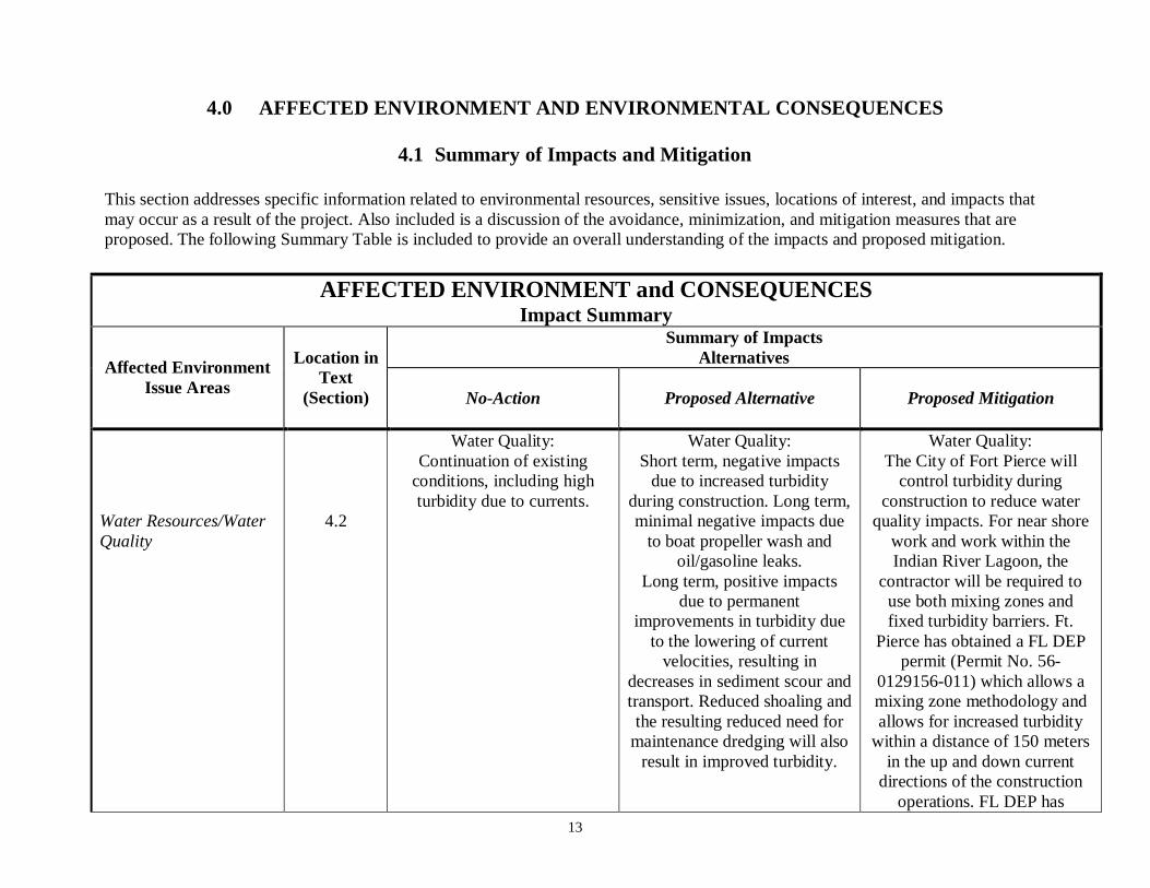
4.0 AFFECTED ENVIRONMENT AND ENVIRONMENTAL CONSEQUENCES
4.1 Summary of Impacts and Mitigation
This section addresses specific information related to environmental resources, sensitive issues, locations of interest, and impacts thatmay occur as a result of the project. Also included is a discussion of the avoidance, minimization, and mitigation measures that areproposed. The following Summary Table is included to provide an overall understanding of the impacts and proposed mitigation.
AFFECTED ENVIRONMENT and CONSEQUENCESImpact Summary
Affected EnvironmentIssue Areas
Location inText
(Section)
Summary of ImpactsAlternatives
No-Action Proposed Alternative Proposed Mitigation
Water Resources/WaterQuality
4.2
Water Quality:Continuation of existing
conditions, including highturbidity due to currents.
Water Quality:Short term, negative impacts
due to increased turbidityduring construction. Long term,minimal negative impacts due
to boat propeller wash andoil/gasoline leaks.
Long term, positive impactsdue to permanent
improvements in turbidity dueto the lowering of current
velocities, resulting indecreases in sediment scour andtransport. Reduced shoaling andthe resulting reduced need for
maintenance dredging will alsoresult in improved turbidity.
Water Quality:The City of Fort Pierce will
control turbidity duringconstruction to reduce water
quality impacts. For near shorework and work within theIndian River Lagoon, the
contractor will be required touse both mixing zones andfixed turbidity barriers. Ft.
Pierce has obtained a FL DEPpermit (Permit No. 56-
0129156-011) which allows amixing zone methodology andallows for increased turbidity
within a distance of 150 metersin the up and down current
directions of the constructionoperations. FL DEP has
14
AFFECTED ENVIRONMENT and CONSEQUENCESImpact Summary
Affected EnvironmentIssue Areas
Location inText
(Section)
Summary of ImpactsAlternatives
No-Action Proposed Alternative Proposed Mitigation
Water Resources/WaterQuality (continued)
4.2
Floodplains:None
Wetlands:None
Floodplains:Long term, minimal impacts
due to the placement of 14.66acres of fill for the Storm
Protection System.Long term, positive impacts to
public property throughprotection during future events
due to the Storm ProtectionSystem.
Wetlands:None
approved a turbidity monitoringprogram that will be
implemented to prevent waterquality impacts from reaching
unacceptable limits
Chromated-copper -arsenatetreated pilings will be wrapped
to prevent leaching into thewater column.
Floodplains:None
Wetlands:None
15
AFFECTED ENVIRONMENT and CONSEQUENCESImpact Summary
Affected EnvironmentIssue Areas
Location inText
(Section)
Summary of ImpactsAlternatives
No-Action Proposed Alternative Proposed Mitigation
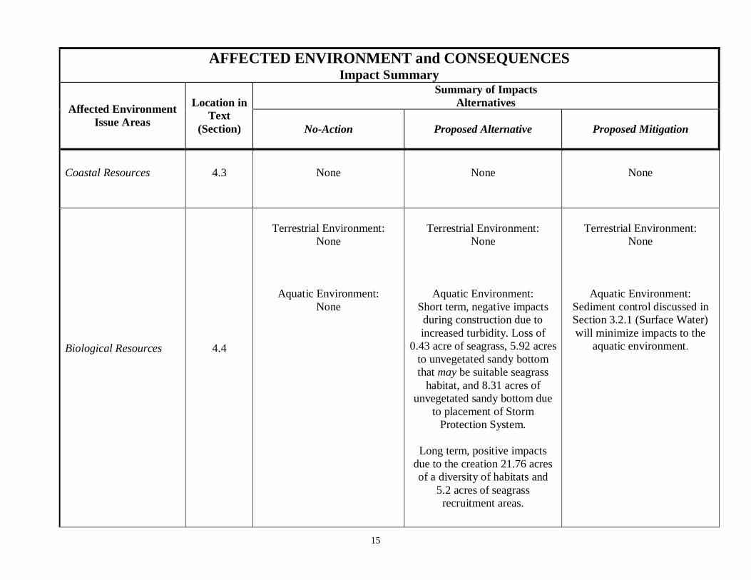
Coastal Resources 4.3 None None None
Biological Resources 4.4
Terrestrial Environment:None
Aquatic Environment:None
Terrestrial Environment:None
Aquatic Environment:Short term, negative impactsduring construction due toincreased turbidity. Loss of
0.43 acre of seagrass, 5.92 acresto unvegetated sandy bottomthat may be suitable seagrass
habitat, and 8.31 acres ofunvegetated sandy bottom due
to placement of StormProtection System.
Long term, positive impactsdue to the creation 21.76 acresof a diversity of habitats and
5.2 acres of seagrassrecruitment areas.
Terrestrial Environment:None
Aquatic Environment:Sediment control discussed inSection 3.2.1 (Surface Water)will minimize impacts to the
aquatic environment.
16
AFFECTED ENVIRONMENT and CONSEQUENCESImpact Summary
Affected EnvironmentIssue Areas
Location inText
(Section)
Summary of ImpactsAlternatives
No-Action Proposed Alternative Proposed Mitigation
Biological Resources(continued)
4.4
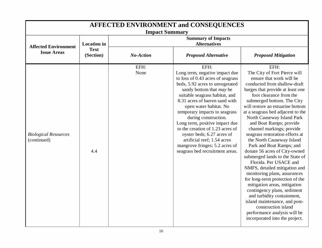
EFH:None
EFH:Long term, negative impact dueto loss of 0.43 acres of seagrassbeds, 5.92 acres to unvegetated
sandy bottom that may besuitable seagrass habitat, and8.31 acres of barren sand with
open water habitat. Notemporary impacts to seagrass
during construction.Long term, positive impact dueto the creation of 1.23 acres of
oyster beds; 6.27 acres ofartificial reef; 1.54 acres
mangrove fringes; 5.2 acres ofseagrass bed recruitment areas.
EFH:The City of Fort Pierce will
ensure that work will beconducted from shallow-draft
barges that provide at least onefoot clearance from the
submerged bottom. The Citywill restore an estuarine bottomat a seagrass bed adjacent to the
North Causeway Island Parkand Boat Ramps; providechannel markings; provide
seagrass restoration efforts atthe North Causeway IslandPark and Boat Ramps; and
donate 56 acres of City-ownedsubmerged lands to the State of
Florida. Per USACE andNMFS, detailed mitigation andmonitoring plans, assurances
for long-term protection of themitigation areas, mitigationcontingency plans, sedimentand turbidity containment,
island maintenance, and post-construction island
performance analysis will beincorporated into the project.
17
AFFECTED ENVIRONMENT and CONSEQUENCESImpact Summary
Affected EnvironmentIssue Areas
Location inText
(Section)
Summary of ImpactsAlternatives
No-Action Proposed Alternative Proposed Mitigation
Biological Resources(continued)
4.4
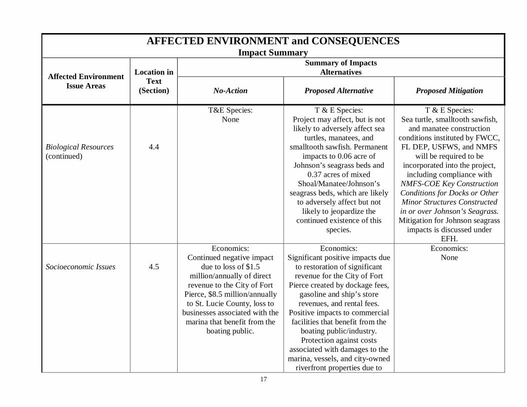
T&E Species:None
T & E Species:Project may affect, but is notlikely to adversely affect sea
turtles, manatees, andsmalltooth sawfish. Permanent
impacts to 0.06 acre ofJohnson’s seagrass beds and
0.37 acres of mixedShoal/Manatee/Johnson’s
seagrass beds, which are likelyto adversely affect but not
likely to jeopardize thecontinued existence of this
species.
T & E Species:Sea turtle, smalltooth sawfish,
and manatee constructionconditions instituted by FWCC,FL DEP, USFWS, and NMFS
will be required to beincorporated into the project,including compliance with
NMFS-COE Key ConstructionConditions for Docks or OtherMinor Structures Constructedin or over Johnson’s Seagrass.Mitigation for Johnson seagrass
impacts is discussed underEFH.
Socioeconomic Issues 4.5
Economics:Continued negative impact
due to loss of $1.5million/annually of directrevenue to the City of Fort
Pierce, $8.5 million/annuallyto St. Lucie County, loss to
businesses associated with themarina that benefit from the
boating public.
Economics:Significant positive impacts due
to restoration of significantrevenue for the City of Fort
Pierce created by dockage fees,gasoline and ship’s storerevenues, and rental fees.
Positive impacts to commercialfacilities that benefit from the
boating public/industry.Protection against costs
associated with damages to themarina, vessels, and city-owned
riverfront properties due to
Economics:None
18
AFFECTED ENVIRONMENT and CONSEQUENCESImpact Summary
Affected EnvironmentIssue Areas
Location inText
(Section)
Summary of ImpactsAlternatives
No-Action Proposed Alternative Proposed Mitigation
Socioeconomic Issues(continued)
4.5
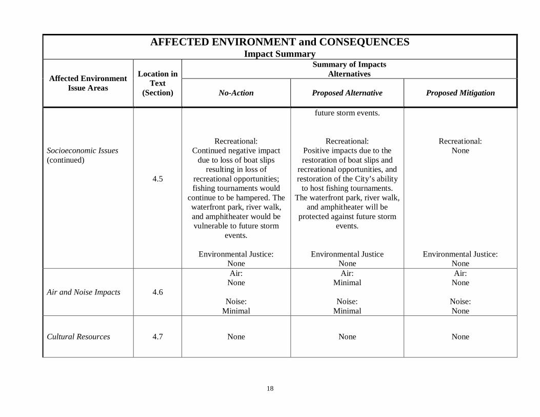
Recreational:Continued negative impact
due to loss of boat slipsresulting in loss of
recreational opportunities;fishing tournaments would
continue to be hampered. Thewaterfront park, river walk,and amphitheater would bevulnerable to future storm
events.
Environmental Justice:None
future storm events.
Recreational:Positive impacts due to therestoration of boat slips and
recreational opportunities, andrestoration of the City’s ability
to host fishing tournaments.The waterfront park, river walk,
and amphitheater will beprotected against future storm
events.
Environmental JusticeNone
Recreational:None
Environmental Justice:None
Air and Noise Impacts 4.6
Air:None
Noise:Minimal
Air:Minimal
Noise:Minimal
Air:None
Noise:None
Cultural Resources 4.7 None None None

19
AFFECTED ENVIRONMENT and CONSEQUENCESImpact Summary
Affected EnvironmentIssue Areas
Location inText
(Section)
Summary of ImpactsAlternatives
No-Action Proposed Alternative Proposed Mitigation
Safety 4.8
Health and Safety:Positive impact due todecrease in incidents of
boating accidents resultingfrom the lowering of boating
traffic.Negative impact due to loss ofdocking facilities to providesafe harbor during storms.
Executive Order 13045:None
Americans with DisabilitiesAct:None
Health and Safety:Negative impact due to increase
in incidents of boatingaccidents resulting from
increases in boating traffic.Positive impacts, including
decrease in boat accidents dueto the lowering of current
velocities, decrease in drowningpotential due to the lower
current velocities, and increasesin docking facilities to provide
safe harbor during storm.
Executive Order 13045:Minimal
Americans with DisabilitiesAct:None
Health and Safety:None
Executive Order 13045:None
American with Disabilities Act:None
Public Services andUtilities
4.9 None None None

20
AFFECTED ENVIRONMENT and CONSEQUENCESImpact Summary
Affected EnvironmentIssue Areas
Location inText
(Section)
Summary of ImpactsAlternatives
No-Action Proposed Alternative Proposed Mitigation
Cumulative andSecondary Impacts
4.10 Cumulative Impacts:None
Secondary Impacts:Loss of business/revenue
could lead to businessclosures, possible reallocation
of land use.
Cumulative ImpactsMinor increases in water
quality impacts to Indian RiverLagoon;
Minor cumulative impacts toEFH and Johnson’s seagrass.
Cumulative impacts to Johnsonseagrass are not expected to
jeopardize its existence.
Secondary Impacts:Possible sediment loading toIndian River Lagoon if Storm
Protection System fails.Johnson’s seagrass impacts due
to increased boat traffic andmaintenance dredging.
Potential for the developmentof new businesses due to
economic revitalization ofdowntown.
Cumulative ImpactsTurbidity curtains and otherBMPs will be used during
construction to reduce waterquality impacts. EFH habitatand seagrass impacts will be
mitigated for through thecreation of mangroves, oysters,and seagrass recruitment areas.
Secondary Impacts:Fort Pierce will conduct
inspections for performanceand integrity of the Storm
Protection System annually andfollowing severe storms.
Impacts to Johnson’s seagrasswill be minimized because the
Indian River Lagoon is ofsufficient depth that propeller
caused turbidity is minimal; nowake zones have been
established which result in theminimization of boat propellersstirring up bottom sediments.Future maintenance dredging
projects will incorporate BMPsto reduce turbidity.
21
4.2 Water Resources
4.2.1 Surface Water and Water Quality
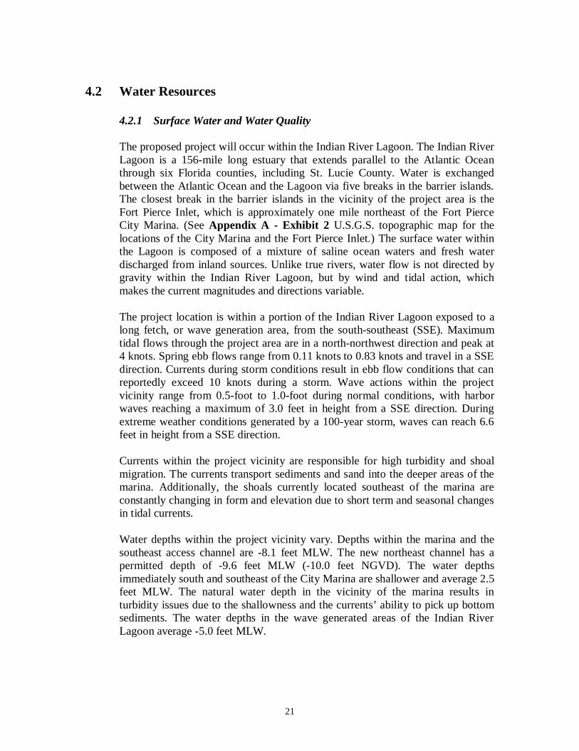
The proposed project will occur within the Indian River Lagoon. The Indian RiverLagoon is a 156-mile long estuary that extends parallel to the Atlantic Oceanthrough six Florida counties, including St. Lucie County. Water is exchangedbetween the Atlantic Ocean and the Lagoon via five breaks in the barrier islands.The closest break in the barrier islands in the vicinity of the project area is theFort Pierce Inlet, which is approximately one mile northeast of the Fort PierceCity Marina. (See Appendix A - Exhibit 2 U.S.G.S. topographic map for thelocations of the City Marina and the Fort Pierce Inlet.) The surface water withinthe Lagoon is composed of a mixture of saline ocean waters and fresh waterdischarged from inland sources. Unlike true rivers, water flow is not directed bygravity within the Indian River Lagoon, but by wind and tidal action, whichmakes the current magnitudes and directions variable.
The project location is within a portion of the Indian River Lagoon exposed to along fetch, or wave generation area, from the south-southeast (SSE). Maximumtidal flows through the project area are in a north-northwest direction and peak at4 knots. Spring ebb flows range from 0.11 knots to 0.83 knots and travel in a SSEdirection. Currents during storm conditions result in ebb flow conditions that canreportedly exceed 10 knots during a storm. Wave actions within the projectvicinity range from 0.5-foot to 1.0-foot during normal conditions, with harborwaves reaching a maximum of 3.0 feet in height from a SSE direction. Duringextreme weather conditions generated by a 100-year storm, waves can reach 6.6feet in height from a SSE direction.
Currents within the project vicinity are responsible for high turbidity and shoalmigration. The currents transport sediments and sand into the deeper areas of themarina. Additionally, the shoals currently located southeast of the marina areconstantly changing in form and elevation due to short term and seasonal changesin tidal currents.
Water depths within the project vicinity vary. Depths within the marina and thesoutheast access channel are -8.1 feet MLW. The new northeast channel has apermitted depth of -9.6 feet MLW (-10.0 feet NGVD). The water depthsimmediately south and southeast of the City Marina are shallower and average 2.5feet MLW. The natural water depth in the vicinity of the marina results inturbidity issues due to the shallowness and the currents’ ability to pick up bottomsediments. The water depths in the wave generated areas of the Indian RiverLagoon average -5.0 feet MLW.
22
There are four water quality monitoring stations within the Indian River Lagoonin the project vicinity, but none of them have had water samples analyzed in thelast five years. Information is available on water quality within the Indian RiverLagoon based on 2005 analytical results.1 In 2005, the Indian River Lagoon’swater quality was impaired and did not meet water quality standards for its class.Impairment was caused by the significant amount of agriculture in the watershed.The main pollutants causing non-attainment of designated use in the Indian RiverLagoon include low dissolved oxygen levels, the presence of coliform bacteria,excess nutrients (from fertilizer runoff), mercury, iron, and lead.
Water within the marina has been classified as Class III Marine Waters withdesignated uses of recreation and the propagation and maintenance of well-balanced fish and wildlife populations. Water quality sampling was conducted forthe purposes of this project. Water quality sampling revealed that dissolvedoxygen, specific conductivity, pH, nutrients, hardness, metals, oil and grease, andpolycyclic aromatic hydrocarbons (PAHs) were generally within limits acceptablefor Class III Marine Waters. Copper was identified as slightly elevated abovewater quality standards for Class III Marine Waters. One sample exceeded thePAH limits.
No-Action AlternativeThe No Action Alternative would not impact surface water quality beyond what iscurrently occurring due to the presence of the inner harbor and adjacentfreshwater inputs. No additional water quality impacts would occur due to boatingactivities or construction activities. No changes would occur to the existingcurrent’s velocities, which would continue to cause high turbidity.
The Proposed AlternativeThe Proposed Alternative will have impacts on surface water quality, bothnegative and positive. Short-term negative impacts will occur due to construction,long term negative impacts will occur due to increased boat traffic. Long termpositive impacts will occur due to the reduction in current velocities. Below is acomplete discussion of these impacts.
Construction ImpactsConstruction activities in the project area will result in temporary, short termimpacts to water quality. Construction will require the installation of piers and theStorm Protection System, both of which will result in temporary increases inturbidity due to sediment bottom disturbances. These turbidity impacts areexpected to be short term and will be minimized by the use of turbidity control.
The City of Fort Pierce has completed a turbidity modeling study which identifiesthe degree of turbidity and the distribution of turbidity plumes within the IndianRiver Lagoon during construction. The model considered both the transient flow
1 Integrated Water Quality Assessment for Florida: 2006 305(b) Report and 303(d) List Update, May 2,2006 from http://www.dep.state.fl.us/WATER/tmdl/docs/2006_Integrated_Report.pdf
23
conditions during a typical tidal cycle, as well as the configuration changes thatwill occur as individual islands are sequentially constructed. The modelsimulations estimated the footprints of the turbidity plumes over a simulated 10hour construction day.
Model simulations were completed for the construction of each individual islandand comprised a total of 13 model runs. Each individual model run wascompared against the standards of a short term turbidity value of >29nephelometric turbidity units (NTU) This value was chosen because FL DEP’swater quality criteria for Class III Marine Waters requires that any discharge intoClass III waters should have turbidity levels that are not more than 29 NTU abovebackground levels. To address the long term effects of turbidity on seagrasspopulations located in the project area, a more conservative number of >15NTU above background levels averaged over a 10-hour construction day waschosen.
Out of the 13 Storm Protection System features, the construction related turbidityfor only a single island, Snook Island, exceeded the impact threshold criteria. Themodel results indicated that a peak of 29.8 NTUs will occur at slack tide, with anaverage of 15.2 NTUs over a 10-hour construction day. No exceedances werepredicted to occur during construction of any of the other Storm ProtectionSystem features.
The City of Fort Pierce has performed elutriate testing to determine possible waterquality impacts that may occur during construction, in addition to turbidityimpacts. Sediments in the project vicinity were analyzed for copper, lead, zinc,arsenic, cadmium, mercury, and PAHs. The results were compared to the Criteriafor Surface Water Classification for Class III: Marine Waters. Testing indicatedthat the sediments will release copper that will result in an exceedance in theClass III marine surface water criteria, but copper already exceeds the Class IIIlimits within and outside the project area.
The City of Fort Pierce has obtained Clean Water Act (Section 404) and Riversand Harbors (Section 10) permits for the project. The permit application for bothSections 401 and 404 are combined in the State of Florida, with the FL DEP andUSACE placing project conditions that will minimize impacts. Ft. Pierce hasobtained the FL DEP Permit Number. 56-0129156-011 and the USACE permitnumber SAJ-1993-41787 (see Appendix B).
The FL DEP permit which has been obtained requires the use of sediment controlmethods to reduce turbidity during construction, and thereby minimize waterquality impacts. Two different methods are permitted for work near shore,turbidity barriers and 150 meter mixing zones; the 150 meter mixing zone methodwill be used within the Intracoastal Waterway. These two methods are discussedbelow.
24
A modified turbidity barrier will be used for work that will be conducted nearshore. Work conducted near shore will be hampered by water depths greater than10 feet and high current velocities. (Fixed turbidity barriers are generallyineffective when currents exceed 1 knot.) These conditions make the use ofconventional turbidity barriers impractical. Existing seagrass beds located justeast of the Storm Protection System must be protected from excessivesedimentation, however. The City of Fort Pierce has determined that a modifiedturbidity barrier will provide some protection and will minimize the eastwardmovement of sedimentation into the seagrass beds. The current directions in theproject vicinity are primarily towards the north and south directions. The City ofFort Pierce will use fixed turbidity barriers that are aligned in the direction of thecurrents. In this layout pattern, the turbidity barriers do not experience the fullhydrodynamic force of the currents since they flow along the barrier and notdirectly against it. The turbidity barriers are effective in controlling the movementof sediment across the barrier alignment but do not influence the transport ofsediments along current directions.
In addition to the modified turbidity barrier, the City of Fort Pierce will requiretheir contractor to use a mixing zone minimization technique. The FL DEP hasapproved a permit that allows for a specially permitted mixing zone for sedimentsthat are transported along current directions. In this method, increased turbidity isallowed within a distance of 150 meters in the up and down current directions ofthe construction operations. A turbidity monitoring program will be installed toprevent water quality impacts from reaching unacceptable limits. The turbiditymonitoring will occur once every hour during construction and will include thesampling of both a background location and a location 150 meters downstream ofthe construction. If the monitoring revealed the turbidity levels 150 metersdownstream of construction exceeded 29 NTUs, work will immediately cease, theFL DEP will be notified, and no work will proceed until approved by the FL DEP.The contractors will be required to modify the work procedures that wereresponsible for the increased turbidity and will be required to install moresediment containment devices.
In addition to modified turbidity barriers and the monitoring of 150-meter mixingzones, water quality impacts will be minimized during construction of the StormProtection System by the construction methods themselves. Geotubes will be usedin the construction of all of the Storm Protection System features. The filter fabricskins of the Geotubes serve to retain a large portion of the fines that contribute toturbidity. In the larger Storm Protection Island, the Geotube will also provide acontainment dike that will retain the fill material and minimize turbidity plumes toadjacent waters.
The 11 Free Form Breakwater Habitat Islands will be constructed first becausethese islands require only upland sand sources, while the Storm Protection Islandand Tombolo Point will be constructed with both upland sand and sand dredgedfrom the marina basin. By using this sequence in the construction, the Breakwater
25
Habitat Islands will act as turbidity curtains during the dredging of the marinabasin. The dredging of the marina basin will occur at the same time as theconstruction of the Storm Protection Island, resulting in a direct deposition of thesand on the cap of the island.
The water quality impacts resulting from the construction portion of the projectare expected to be short term and temporary, and are not expected to besignificant.
Permanent negative impactsThe restoration of the outer harbor will result in an increase in capacity of sevenboats over the pre-disaster conditions. This increased boating will result in veryslight increases in turbidity due to propeller action and increases in water qualityimpacts due to oil and gasoline leakage. The Indian River Lagoon is of sufficientdepth that propeller caused turbidity is minimal, and no wake zones have beenestablished within the vicinity of the City Marina, which result in theminimization of boat propellers stirring up bottom sediments. Increases inturbidity from additional boating are therefore not expected to be significant.Water quality impacts from oil and gasoline leakage from boats will also increasedue to the increase in boating traffic. These impacts are also expected to beminimal.
Pilings that have been treated with chromated-copper arsenate in order to preventdeterioration will be wrapped to prevent the possible leaching copper into thewater column. Water quality in the project area would not experience increases incopper due to the pilings.
Permanent positive impactsLong term decreases in turbidity are expected as a result of the ProposedAlternative. Tidal currents within the Indian River Lagoon in the vicinity of theproject are currently 4 knots; this velocity causes some turbidity due to the stirringup of bottom sediments. The placement of the Storm Protection System for hazardmitigation will reduce the currents to 1 knot during normal tide conditions, whichwill most likely result in lower turbidity levels. Additionally, the installation ofthe Storm Protection System will reduce the ebb flow currents, which areresponsible for transport and deposition of sediments and sand into the deeperareas of the marina. The reduced ebb currents will result in less sediment transportand deposition. This will be a benefit because the need for maintenance dredgingwill be reduced, thereby reducing the periodic turbidity that occurs due to thisactivity. Finally, the installation of the Storm Protection System will reduce theshoal migration that is currently occurring southeast of the marina. The shoalsmove inland due to water currents and result in the need for regular maintenancedredging. The reduced currents will reduce shoal migration, again reducing theneed for maintenance dredging.
26
The strong tidal current regime maintains excellent circulation through theproposed marina and breakwater island complex. Therefore, water quality will notbe impacted by the re-instated outer harbor operations. Adequate flushing hasbeen confirmed by a hydrographic study performed by Tetra Tech EC Inc., whichdemonstrated that the construction of the Storm Protection System will notcontribute to a violation of any Florida water quality standards. The modeladditionally demonstrated that there will be no stagnant areas within the marinathat could contribute to chronic buildup of contaminants.
The City Marina is designated as a Clean Marina facility. As a Clean Marina,there are best management practices (BMPs) in place to address possible sourcesof pollutants before they can become a problem. All docking facilities will havesewage pump-out capabilities. Every slip will be in close proximity to a pump-outconnection, and the slip occupants will not have to leave the slip in order to emptytheir marine sanitary devices. Additional fueling facilities will not be included inthe outer harbor. As a Clean Marina, the City Marina has a Spill Prevention andControl Plan for the marina.
In summary, the Proposed Alternative will have short-term negative impacts onwater quality due to increased turbidity during construction, but will have a long-term beneficial impacts on turbidity due to decreases in current velocity. TheStorm Protection System will reduce the amount of sedimentation and shoalmigration that occurs, resulting in a reduction in the need for maintenancedredging. The reduction of currents to 1 knot during normal tide conditions willallow for adequate flushing of the marina in order to maintain dissolved oxygenlevels and reduce pollutant loads. Both the FL DEP and the USACE permitscontain permit conditions that will ensure that water quality impacts will not besignificant.
4.2.2 Floodplains
Executive Order (EO) 11988 requires federal agencies to avoid, to the extentpossible, long- and short-term adverse impacts associated with the occupancy andmodification of floodplains, and to avoid direct and indirect support of floodplaindevelopment wherever there is a practicable alternative. FEMA’s regulations forcomplying with EO 11988 are promulgated in 44 CFR Part 9 and include aneight-step decision making process.
The Fort Pierce City Marina is located in a Coastal High Hazard Zone. Themarina area is subject to storm surge flooding that enters through the nearby FortPierce Inlet into the waters of the Indian River Lagoon. The inner and outermarina basins are within a VE-zone (coastal flood zone with velocity hazard) witha 100-year flood level of +8-feet NGVD. This base flood elevation includes awave height component. The 100-year still water elevation in the Indian RiverLagoon is 5.1-feet NGVD. The adjacent narrow coastal fringe in the marina areais in an AE-zone with a 100-yr flood elevation of +5-feet NGVD. Immediately
27
landward of the coastal fringe, the upland area becomes an X-zone that is outsideof the 100-year flood zone [FEMA, 1991; FEMA Flood Insurance Rate Map(FIRM) St. Lucie County, Florida and Incorporated Areas, Panel 179 of 410, MapNumber 12111C0179 G, November 4, 1992]. (The information described above isshown in Appendix A, Exhibit 8a – Flood Insurance Rate Map, and Exhibit 8b– FIRM Zone Table.)
Avoidance of the 100-year floodplain for a marina is not possible because amarina is a functionally dependent use of the floodplain. A disaster-wide initialpublic notice was published state-wide December 3 through 15, 2004; it waspublished in the Okeechobee News on December 5, 2004. A general final publicnotice was published state-wide November 11-December 1, 2005; it waspublished in the Palm Beach Coast on November 23, 2005. USACE published apublic notice in conjunction with the Section 404 Clean Water Act permittingprocess on February 19, 209. See Appendix C for copies of these public notices.
A Public Notice was published by FEMA on October 21, 2010 in the Fort PierceTribune. This Public Notice advised the public that a Draft EA had beendeveloped for the project. The Draft EA was made available to interested partiesthrough publication on FEMA’s websitehttp://www.fema.gov/plan/ehp/envdocuments/ea-region4.shtm and by distributionwithin the community. The Draft EA served as the final public notice for thisproject.
No-Action AlternativeThe No-Action Alternative would have no impacts on the floodplain. The innerharbor would be subject to damages during future flood events due to its locationwithin a VE-zone.
The Proposed AlternativeThe Proposed Alternative is for the replacement of the outer harbor andinstallation of a Storm Protection System. The Proposed Alternative will result inthe placement of approximately 14.66 acres of fill into the Indian River Lagoondue to the installation of the Storm Protection System. This amount of fill will beminimal when compared to the amount of flood storage available for the IndianRiver Lagoon. The inner and outer harbors will be subject to damages duringstorm surges during future storm events due to their location within a VE-zone,but will be less vulnerable due to the installation of the Storm Protection System.The Storm Protection System is designed to protect the inner and outer harborsfrom a 100-year storm event and the resulting flood. Additionally, the StormProtection System will serve to protect publicly-owned river front property(described in Section 3.3) from a 100-year storm event.
28
4.2.3 Wetlands
EO 11990, Protection of Wetlands, requires federal agencies to take action tominimize the loss of wetlands. The USACE regulates the discharge of dredged orfill material into waters of the U.S., including wetlands, pursuant to Section 404of the Clean Water Act. FEMA generally relies on the Clean Water Act, Section404 Permit process to protect wetlands for projects that could impact wetlands. Inaddition, FEMA applies an eight-step decision making process to comply with EO11990. FEMA’s regulations for complying with EO 11990 are promulgated in 44CFR Part 9. The NEPA compliance process also requires the identification of anydirect or indirect impacts to wetlands which may result from federally fundedactions.
The National Wetland Inventory (NWI) map depicting wetlands in the Fort Piercequadrangle by the U.S. Fish and Wildlife Service (USFWS) Geocortex InternetMapping Framework Wetlands Online Mapper was examined for informationrelated to the presence of wetlands within the project area. The NWI mapindicates that there are two types of wetlands located in the project vicinity. Theshoal area is noted as estuarine and marine. The deeper areas in the Indian RiverLagoon are noted as estuarine and marine, deepwater. (see Appendix A, Exhibit9 – NWI map). Both of these wetland types are considered open water habitatsand not wetlands by the USACE and the U.S. Environmental Protection Agency(USEPA).
A site visit conducted by a Professional Wetland Scientist confirmed thatwetlands are not directly or indirectly associated with the proposed site. Therewould therefore be no wetland impacts from any of the alternatives.
4.3 Coastal Resources
4.3.1. Coastal Zone Management Act
The Coastal Zone Management Act (CZMA) requires states with shorelines incoastal zones to have a Coastal Zone Management Plan (CZMP) to reduceuncontrolled coastal development. Projects falling within these coastal zones mustbe evaluated to ensure that they are consistent with the CZMP. Projects receivingFederal assistance must follow the procedures outlined in 15 CFR 930.90 –930.101 for consistency determinations. Under these procedures, grant applicantsmust submit their proposals to the State agency in charge of the CZMP to obtain aconsistency determination. FEMA cannot approve a grant without the Stateagency’s consistency approval.
The State of Florida implements its authority for the CZMA through the issuanceof Section 401 Clean Water Act permits, issuance of Environmental ResourcePermits, and the Coastal Construction Control Line (CCCL) Program. The CCCL
29
program establishes a line along sandy beaches within the State for which anywork occurring seaward of the line requires a FL DEP permit. The line isestablished on each beach based on a 100-year storm event and establishes thelandward limit of jurisdiction.
The project location is not located seaward of the CCCL line; the Indian RiverLagoon is part of Florida’s Intracoastal Waterway and is separated from theAtlantic Ocean. The project location is therefore landward of the CCCL line andwould not require a CCCL permit.
No-Action AlternativeThe No-Action Alternative would not require an Environmental Resource Permit.It would have no effect on the coastal zone.
Proposed AlternativeThe Proposed Alternative requires a Section 401 Clean Water Act permit and anEnvironmental Resource Permit. Ft. Pierce has obtained a FL DEP permit (PermitNumber 56-0129156-011) and a USACE permit (Permit Number SAJ-1993-41787). Issuance of these permits assures compliance with the CZMA. FEMAfunding will be conditional upon the City of Fort Pierce being in compliance withall permit conditions.
Coordination with the St. Lucie County Mosquito Control and CoastalManagement Services resulted in a request that the City of Fort Pierce coordinateduring construction with Port of Fort Pierce shipping operators and recreationalboating interests located in the Port. By doing so, compatibility between theconstruction activities and ongoing Port- and recreation-related activities, as wellas compliance with CZMA, will be ensured.
4.3.2 Coastal Barrier Resource Act
The Coastal Barrier Resource Act (CBRA), enacted in 1982, designated variousundeveloped coastal barrier islands as units in the Coastal Barrier ResourcesSystem. The expenditure of Federal funds in CBRA Units is very limited andsubject to FEMA’s regulations at 44 CFR 206.340 (Subpart J).
No portions of the Fort Pierce City Marina, nor any portions of the Indian RiverLagoon where the proposed Storm Protection System will be installed, are locatedwithin CBRA units. There would be no impacts to CBRA units from any of thealternatives.
4.3.3 Navigation Impacts
The proposed project will occur within the Indian River Lagoon. The Indian RiverLagoon is a 156-mile estuary that extends parallel to the Atlantic Ocean throughsix Florida counties. It is utilized extensively for commercial and recreationalboating and fishing.
30
The design of the Storm Protection System contained within the ProposedAlternative has been designed to prevent any obstructions to navigation. Neitherthe public’s use of the waterway nor the neighboring proprietors’ access to thewaterway will be impeded. The Storm Protection Island and 11 Free FormBreakwater Habitat Islands will be constructed on top of existing shoals, withinareas that are currently too shallow for navigation. Boaters currently use a channellocated to the north of the marina to access the inner marina. The ProposedAlternative will utilize the same channel to access the outer marina, maintainingthe same navigability.
4.4 Biological Resources
4.4.1 Terrestrial Environment
The local terrestrial environment in the project area has been developed as amarina, public parks, or commercial facilities. The marina, park, and associatedcommercial facilities are composed of pavement, concrete, or mowed lawn. TheIndian River Memorial Park to the north and the Gazebo Park to the south containmowed lawn with planted palm trees. There is no undisturbed terrestrialenvironment in the project area.
There would be no terrestrial environment impacts from any of the alternatives.
4.4.2 Aquatic Environment
The aquatic environment in the project vicinity consists primarily of open waterwithin the marina and the Indian River Lagoon. The lagoon has soft sandysubstrates with shell hash. Composition is predominantly fine sand mixed withshell fragments. Drift algae are commonly found within the project area, primarilycomprised of red algae species (Gracilaria spp. and Laurencia spp.) and brownalga (Sargassum natans). Although less abundant, green algae species are alsopresent in the project vicinity (Caulerpa mexicana, Caulerpa prolifera, CaulerpaSertularioides, and Acetabularia spp.) Drift algae accumulations are a significantbiological feature of the Indian River Lagoon ecosystem.2,3 There are shoalswithin the project vicinity, seagrass beds, and un-vegetated tidal bottoms, butthere are currently no islands within the Indian River Lagoon in the project area.Additionally, mangrove populations, oysters, and hardbottom reefs are notcurrently present in the project area.
2 Thompson, M.J. 1978. Species composition and distribution of seagrass beds in the Indian River Lagoon,Florida Fla. Sci. 4:90-963 Virnstein, R.W. and P.A. Carbonara. 1985. Seasonal abundance and distribution of drift algae andseagrasses in the mid-Indian River Lagoon, Florida. Aquat. Bot. 23:76-82

31
No-Action AlternativeThe No-Action Alternative would have no affect on the aquatic environment in theproject area.Proposed AlternativeThe Proposed Alternative will have minimal, short term negative impacts on theaquatic environment. Installation of the piers for the new docks and constructionof the Storm Protection System will result in increases in turbidity, which has thepotential to adversely affect drift algae. This impact is not expected to besignificant.
The Proposed Alternative will have negative, long term, permanent impacts on14.66 acres in the Indian River Lagoon, of which 0.43 acres consist of seagrassand 14.23 is unvegetated, sandy bottom. This impact is not considered significantsince, 8.31 of the 14.23 acres of unvegetated, sandy bottom will not likely supportseagrasses because of existing water depths and bottom scouring from the highcurrents in the area.
The Storm Protection System will have long term, positive impacts by providinghabitat that will be included in the islands. The Storm Protection System will beconstructed of various materials placed at different elevations to provide adiversity of habitat. In total, the Storm Protection System will be 14.66 acres insize, composed of a large Storm Protection Island, 11 Free Form BreakwaterHabitat Islands, and a peninsular feature called Tombolo Point. These featureswill create a mosaic of habitats for fish, shellfish, wildlife, and birds. In total,21.76 acres of habitat will be created, including coastal dunes (shorebird habitat),mangrove fringes, lime-rock habitat (for hard bottom communities), oyster reefs,and seagrass beds.
The main Storm Protection Island will provide 4.25 acres of sandy/shell coastaldune community which could support terns and other shorebirds, 1.30 acres of redmangroves, 1.14 acres of oyster bed recruitment areas, and 2.41 acres of limerockhabitat. The same considerations will be included in the design of the 11 smallerFree Form Breakwater Habitat Islands and Tombolo Point. With these portions ofthe proposed Storm Protection System, a total of 4.55 acres of coastal dunehabitat, 1.54 acres of red mangrove fringe areas, 1.23 acres of oyster bedrecruitment areas, and 6.27 acres of submerged limerock habitat will be created.
Approximately 4.55 acres of coastal dune community will be created. Manyshorebirds could utilize this area for feeding, including the endangered least ternand the threatened roseate tern. It is possible that this habitat may also be used fornesting. It is anticipated that the dune vegetation may be suitable for other birdssuch as willet, American oystercatchers, Wilson’s plovers, Caspian terns, andgull-billed terns.
Approximately 1.54 acres of mangrove fringe will be created. The mangrovefringes will improve water quality, provide habitat for estuarine species, and
32
stabilize the shorelines of the habitat islands. Red mangroves are proposed for thisproject because have the highest ecological value; they create habitat for lobsterand fish and their extensive root system is best for shoreline stabilization. The redmangroves are also expected to attract wading birds and provide nursery habitatfor fish (because of their prop roots).
Approximately 1.23 acres of oyster bed recruitment areas will be created. Theoyster bed recruitment areas are expected to provide opportunities for new oysterbed resources in the project vicinity. The Storm Protection Island and Free FormBreakwater Habitat Islands will have sections constructed out of oyster shell,which is hoped to allow for oyster bed recruitment. The Storm Protection Systemwill reduce current velocities and when combined with the oyster shell substrate,will encourage oyster bed development. Oyster beds enhance water quality andserve as habitat for a variety of estuarine species.
Approximately 6.27 acres of limerock habitat will be created. The submergedlimerock will function as an artificial reef and provide substrate for vegetation,corals, and other organisms. These hard bottom communities will also serve asjuvenile fish nurseries.
In addition, approximately 5.2 acres of seagrass beds are expected to be recruitedinto the project area. The installation of habitat islands will reduce wave andcurrent energy within the project area, which in turn will serve to encourage therecruitment of seagrasses into the shallow areas, as well as associatedinfaunal/epifaunal organisms. The recruited seagrass beds will improve waterquality, provide habitat for estuarine species, and stabilize the shorelines of thehabitat islands. Seagrasses improve water quality by cycling organics, chemicalelements, and nutrients from the water and will clarify the water by trappingsediments from the water column. As habitat, the recruited seagrass beds willfunction as sources of food, areas of shelter, and serve as essential nursery areasfor commercial and recreational fishery species and invertebrates.
Sand for the veneer on the Storm Protection Island and Tombolo Point will beobtained from maintenance dredging of the outer harbor to the permitted depth of-8 MLW. The dredging will restore the harbors to the USACE permittedelevations and will produce approximately 8,683 cubic yards of sand. Using thesand obtained from this dredging will insure that the sand cover of thesecomponents of the Storm Protection System will consist of native material.
To insure that the habitat components of the Storm Protection System will besuccessful, the system will be monitored and maintained. Success criteria havebeen established, as well as frequency and methodology of monitoring. Five yearsof ecological monitoring, with reports submitted to FL DEP and USACE, will berequired. Maintenance activities that will occur include invasive species removal,debris removal, and sign maintenance. Maintenance will occur twice annually,with reports submitted to FL DEP and USACE.
33
Once completed, ecological resources on the Storm Protection System will not besubject to impact from recreational use. The permitting agencies have required theCity of Fort Pierce to implement a city ordinance that prohibits persons fromentering the top of the islands created by the Storm Protection System. Signs willbe posted advising that there is no access allowed on any of the islands orTombolo Point.
4.4.3 Essential Fish Habitat
The Magnuson-Stevens Fishery Conservation and Management Act of 1996protects fishery resources found off the coasts of the United States, anadromousspecies, and Continental Shelf fishery resources of the United States. Included inthis protection is the protection of essential fish habitat (EFH), or waters andsubstrate necessary to fish for spawning, breeding, feeding, or growth to maturity.
Mangroves are listed as an EFH by the South Atlantic Fishery ManagementCouncil. They are an estuarine scrub/shrub EFH for shrimp, red drum, snapper,grouper, and spiny lobster. Mangroves provide habitat and nursery grounds for awide variety of marine organisms, many of which have important recreational orcommercial fisheries value. Mangroves also serve as breeding and roosting sitesfor many wading birds, including those that are listed as threatened or endangeredspecies. Mangroves also improve water quality by uptaking nutrients andchemicals from the water and stabilizing shorelines. Historically, some of theshoal areas located within the Indian River Lagoon were islands which containedmangrove populations. Mangrove populations are not currently present in theproject vicinity.
Oysters are listed as an EFH by the South Atlantic Fishery Management Councilbecause they provide critical habitats for commercial and recreations fisheriesspecies. They create habitat for many estuarine species of plants and animals,including shrimp, speckled sea trout, and drum. Oysters also enhance waterquality by acting as biofilters. Oyster populations are not currently present in theproject area.
Seagrass is considered an EFH by the South Atlantic Fishery ManagementCouncil; it provides estuarine and marine submerged aquatic vegetation forshrimp, red drum, snapper, grouper, and spiny lobster. As habitat, seagrassesfunction as a source of food, area of shelter, and as essential nursery areas forcommercial and recreational fishery species and invertebrates. There are someshoals within the Indian River Lagoon that contain seagrass beds. Seagrasssurveys were conducted in 2005, 2006, and 2007 in the vicinity of the outerharbor, the proposed Storm Protection System, and an area south of the proposedStorm Protection System. A total of 96.48 acres of submerged bottoms weresurveyed to determine the extent of the seagrass populations in the project area.

34
A total of 5.13 acres of seagrass habitat have been mapped in the areas surveyedin the three years. (See Appendix A, Exhibit 10 for the locations of existingseagrass beds.) The seagrass colonies in the project vicinity are made up of amixed species population, including Syringodium filiforme, Halophila wrightii,Halophila decipiens, and Halophila johnsonii. All of the seagrass beds are locatedin the outer harbor, there are no seagrass beds inside of the inner harbor.
The project area contains un-vegetated tidal bottom, which is considered an EFH.
There are no hardbottom reefs in the project vicinity.
The project area is known EFH for penaeid shrimp complex, red drum, reef fish,stone crab, spiny lobster, migratory/pelagic fish, and snapper/grouper complex.
No-Action AlternativeThe No-Action Alternative would have no affect on EFH in the project area.
Proposed AlternativeThe Proposed Alternative’s reconstruction of the outer harbor will have minorimpacts on EFH. The creation of the Storm Protection System will impactapproximately 14.66 acres of EFH habitat, including 14.23 acres of un-vegetatedsandy bottom and 0.43 acres of seagrass. The 14.23 acres of un-vegetated sandybottom consist of 5.92 acres of bottom that may be suitable as seagrass habitatand 8.31 acres of bottom that are not suitable as seagrass habitat. (See AppendixA, Exhibits 11a and 11b for plan views of the impact areas of the StormProtection Island and Free Form Breakwater Habitat Islands, respectively).
No other additional permanent seagrass impacts are anticipated from theProposed Alternative. The physical modeling that was conducted for theProposed Alternative indicates that the current velocities that will exist within theproject vicinity after installation of the Storm Protection System will not result inscour to the existing seagrass beds, nor will it result in the placement of sedimentsinto the existing beds. Additionally, the City of Fort Pierce will require thecontractors’ watercraft associated with the construction of the facility to operateonly within waters of sufficient depth so as to preclude bottom scouring, propdredging, or damage to seagrass beds.
The Storm Protection System was designed to avoid and minimize seagrassimpacts to the greatest extent practicable. The Proposed Alternative was chosenafter all practicable alternatives were evaluated and considered. The ProposedAlternative is the design that impacts the least amount of seagrass while stillproviding the necessary degree of storm protection.
The potential for temporary impacts to seagrass populations due to increasedturbidity during construction was assessed. Model simulations were completed forthe construction of each individual island and compared against a value of 29
35
NTUs at any given time, or 15 NTUs over a 10-hour construction day. Out of the13 Storm Protection System features, the construction related turbidity for only asingle island, Snook Island, exceeded the impact threshold criteria. The modelresults indicated that turbidity could reach 29.8 NTUs, with an average of 15.2NTUs occurring over a 10-hour construction day in the vicinity of Snook Island.The model indicated that the plume area will be 191 square feet (0.0044 acres).The area of this plume was overlaid on a map indicating the locations of seagrassbeds identified during three years of seagrass surveys. The results indicated thatthe turbidity plume will not occur where seagrass beds are currently located.Therefore, no secondary impacts to seagrass are expected.
The Proposed Alternative is expected to have long term, positive impacts on EFHby creating seagrass recruitment areas, incorporating EFH into the StormProtection System, restoring damaged seagrass beds at two State of Florida-owned locations, and deeding submerged land containing EFH to the State ofFlorida. These positive impacts are discussed below.
Positive impacts to EFH will occur through the provision of 5.2 acres of seagrassrecruitment areas and the City of Fort Pierce’s proposed mitigation for seagrassimpacts. The Storm Protection System will reduce the current velocities withinthe project area. Currently, up to 4 knot flows in the vicinity of the project preventseagrass recruitment. The slower current velocities that will be present followinginstallation of the Storm Protection System will promote seagrass recruitment;additionally, the shape of the proposed Storm Protection Island and Free FormBreakwater Habitat Islands, and the planted mangroves that will promotesediment accumulation within the crescents, will encourage seagrass recruitment.Modeling determined that 5.2 acres of seagrass recruitment areas will result fromthe project based on current velocities and water depths (which relate to availablelight). (See Appendix A, Exhibit 12 for plan views of seagrass recruitmentareas). The recruited seagrass beds will improve water quality and provide habitatfor estuarine species.
Positive, long term impacts from the Proposed Alternative will also incorporate ofEFH into the Storm Protection System. Overall, approximately 1.54 acres ofmangrove fringes, 1.23 acres of oyster recruitment areas, and 6.27 acres oflimerock reefs will be created. The 1.54 acres of mangrove fringes and 1.23 acresof oyster recruitment areas are considered EFH by the South Atlantic FisheryManagement Council.
Additional mitigation required for the impacts to 0.43 acres of seagrass will occuras a requirement of the Section 404 permit from the USACE and the FL DEPpermit. Additional mitigation that is being required as a condition of the USACEand/or FL DEP permits includes:
1. All work will be conducted from a shallow-draft barge. The bargewill be required to operate within waters of sufficient depth (one-
36
foot clearance from the deepest draft of the vessel to the top ofsubmerged resources) to preclude bottom scouring, propellerdredging, or damage to submerged surfaces. Piles will be drivenfrom barge-mounted cranes.
2. Restoration of estuarine bottom to enhance seagrass recruitmentwithin an existing seagrass area adjacent to the North Causeway inFort Pierce will occur. Nearby spoil islands will be scraped downand 2.34-acres of a dredge hole will be filled and then coveredwith the scrapings from the spoil islands. Bird stakes will be addedto the area to encourage roosting of waterfowl, which will addnatural fertilizer for revegetating the seagrass beds.
3. The City of Fort Pierce will install channel markings at the NorthCauseway Island Park and Boat Ramps to protect existing seagrassbeds from boaters using these ramps. Existing seagrass damagewill undergo restoration where prop scars are not naturally healing.
4. The City of Fort Pierce will deed 26 acres of submerged land to theState of Florida. This 26-acre parcel contains pristine seagrassbeds, tidal flats, and submerged mangrove areas; it is locatedimmediately adjacent to the State of Florida’s Fort Pierce InletState Park. An additional 30 acres will be given to the State asproprietary public interest. This property transfer will offset thefunctional loss served by barren sand habitat and water columnEFH that will be lost due to the Storm Protection System. It willplace EFH under State protection, allowing it to remain underprotection in perpetuity.
5. Success of 3 acres of the potential 5.2 acres of seagrass recruitmentareas will be required as mitigation.
In summary, permanent impacts will occur to seagrass beds as a result of theinstallation of the Storm Protection System; impacts will occur to 14.66 acres ofEFH, most of which is un-vegetated tidal bottom. Included in these 14.66 acres is0.43 acres of seagrass beds.
The Proposed Alternative is expected to have long term, positive impacts on EFHby creating 5.2 acres of seagrass recruitment areas. The project is expected tohave positive impacts to EFH in the form of the Storm Protection System, whichwill create EFH habitat in the form of mangrove fringes, oyster recruitment areas,and limerock reefs. Additionally, the City of Fort Pierce will restore damagedseagrass beds at the North Causeway in Fort Pierce; provide channel markingsand restore seagrass beds at the North Causeway Island Park and Boat Ramps;and deed 56 acres of open water and seagrass habitat to the State of Florida.
There is some risk that the proposed EFH mitigation may not function asdesigned. In recognition of this potential, extensive coordination with resourceagencies has resulted in requirements of the FL DEP/USACE permits to includemeasures to support mitigation success. EFH protective measures including
37
detailed mitigation and monitoring plans, assurances for management of habitatareas, mitigation contingency plans, sediment and turbidity containment BMPs,island maintenance, and post-construction island performance analysis will all beincorporated into the project. Richard Czlapinski or Brian Proctor of Tetra Techcan provide a copy of these plans upon request (see Section 10.0 for contactinformation). Per the USACE permit, if any of the proposed mitigation does notfunction as designed despite maintenance and management plans, alternatecompensatory mitigation sufficient to compensate for the loss of aquatic functionswill be required.
4.4.4 Threatened and Endangered Species
Under Section 7 of the Endangered Species Act (ESA), as amended, Federalagencies, in consultation with the USFWS or the NMFS for marine mammals andfish, are required to evaluate the effects of their actions on threatened orendangered species and their critical habitats, and to take steps to conserve andprotect these species.
In accordance with Section 7 of the ESA of 1973, the project area was evaluatedfor the potential for occurrences of federally-threatened and endangered species.Formal consultation with NMFS and USFWS has occurred in conjunction withthe USACE permit application process for the project. Technical assistance hasbeen provided by USFWS and NMFS for the purpose of providing information insupport of this EA.
Smalltooth sawfish (Pristis pectinata) is a federally endangered species found inshallow, subtropical waters. Historically found from Long Island, NY to Brazil,this species is now found mainly off of Florida’s coast. The Indian River Lagooncontains habitat that is utilized by this fish.
Sea turtles are known to utilize the Indian River Lagoon. Species include thefederally threatened loggerhead (Caretta caretta) and green sea (Cheloniamydas); and the federally endangered leatherback (Dermochelys coriacea),hawksbill (Eretmochelys imbricate), and Kemp’s ridley (Lepidochelys kempii).There are no known nesting sites for sea turtles in the immediate vicinity of theproject.
Johnson’s seagrass (Halophila johnsonii), a federally threatened plant, is onlyfound along a 125-mile stretch of Florida coast between Indian River County andMiami-Dade County. Johnson’s seagrass occurs in patches throughout its rangeand is present in the project area, primarily in mixed seagrass beds.
The project area contains West Indian manatee (Trichechus manatus) criticalhabitat and is known to be inhabited by manatees (federally listed as endangered).The project is located adjacent to Moore Creek, which was a discharge point forwarm water from the Fort Pierce Utility Authority’s H.D. King Power Plant. Thisplant was decommissioned in May 2008 and no longer provides a warm water
38
discharge point. Manatee utilization of Moore Creek is expected to be reduced asa result of this. Manatees may continue to use the area because of seagrass beds inthe project vicinity; they are currently found in more sheltered portions of theIndian River Lagoon.
No-Action AlternativeThe No-Action Alternative would have no affect on threatened or endangeredspecies in the project area.
Proposed AlternativeFormal consultation with USFWS and NMFS through the issuance of a BiologicalOpinion for smalltoothed sawfish, swimming sea turtles, and Johnson’s seagrasshas occurred through the USACE permitting process. The NMFS has determinedthat the Proposed Alternative
may affect, but is not-likely to adversely affect, endangered small toothedsawfish and endangered/threatened swimming sea turtles,is likely to adversely affect Johnson’s seagrass, but it is not likely tojeopardize its continued existence, andis not likely to adversely affect the endangered West Indian manatee.
A copy of the Biological Opinion can be found in Appendix B.
Conservation measures for the minimization of potential impacts required by theNMFS and the USFWS will be incorporated into the project as USACE and FLDEP permit conditions. Impacts and minimizations measures are discussed below.
Small Toothed Sawfish and Sea Turtles
The NMFS has determined that the Proposed Alternative may affect, but is not-likely to adversely affect, endangered smalltoothed sawfish andendangered/threatened swimming sea turtles.
Neither smalltooth sawfish impacts nor sea turtle impacts are anticipated fromconstruction of the project, but impacts could occur during dredging operations.The marina will be dredged to a depth of -8.0 feet MLW as part of the project. Itis rare, but turtles and fish have been known to be caught up in dredgingequipment. NMFS determined in their Biological Opinion that the risk of injuryor death resulting from interactions with equipment or materials is discountable asthese species are highly mobile and can easily avoid these interactions. Specialconditions will be placed by NMFS on the project for the protection of sea turtlesand smalltooth sawfish to further reduce the chance of interaction. (A copy ofNMFS’s March 23, 2006 Sea Turtle and Smalltooth Sawfish ConstructionConditions can be found in Appendix B.) The following is a summary of theseconditions:
39
all personnel associated with the project must be aware of the potentialpresence of sea turtles and smalltooth sawfish. All construction personnel willbe responsible for observing water-related activities for the presence of thesespecies;all construction personnel must be aware that there are civil and criminalpenalties for harming, harassing, or killing these species;siltation or turbidity barriers will be constructed so that neither sea turtles norsmalltooth sawfish can become entangled;siltation barriers may not block sea turtle or smalltooth sawfish entry to or exitfrom designated critical habitat;all vessels associated with the construction project will operate at “nowake/idle” speeds at all times;if a sea turtle or smalltooth sawfish is seen within 100 yards of theconstruction, all appropriate precautions will be implemented; andif a sea turtle or smalltooth sawfish is seen within 50 yards of the construction,operation of any mechanical construction equipment will cease immediately.
NMFS has also determined in their Biological Opinion that the creation ofadditional mooring docks will not necessarily introduce new vessels nor increasevessel traffic. If new vessels are introduced, the number of additional boatsaccommodated by the docks is far below the level of vessel traffic that availableinformation indicates is associated with vessel strikes. The effects resulting fromloss or exclusion of foraging and refuge habitat will be insignificant. NMFSconcluded that the project is not expected to create the likelihood of injury byannoying them to such an extent as to significantly disrupt behavioral patterns.
Johnson’s Seagrass
Impacts are anticipated to Johnson’s seagrass due to the construction of the StormProtection System. Full underwater surveys were conducted in 2005, 2006, and2007 for the purposes of mapping seagrass populations. Based on these surveys,5.13 acres of seagrass beds are located in the project vicinity, of which 0.43 acrewill be impacted by the Proposed Alternative through displacement and shading.The beds that will be impacted include mixed beds that contain five species ofseagrass, including Johnson’s seagrass, as well as beds that contain just Johnson’sseagrass. Of this 0.43 acre total, 0.06 acres of impacts will occur in mono-specificbeds of Halophila johnsonii; 0.04 acres of impacts will occur in seagrass beds thatcontain H. johnsonii plus shoal grass (Halodule wrightii), manatee grass(Syringodium filiforme), and paddle grass (Halophila decipiens).
A Biological Opinions has been issued by NMFS, along with recommendedminimization and mitigation requirements. Although 0.43 acre of impacts toseagrass beds will occur, the amount of Johnson’s seagrass is a small percentageof this impact. Secondary impacts will be minimized through implementation ofNMFS conditions identified in the NMFS-COE Key Construction Conditions forDocks or Other Minor Structures Constructed in or over Johnson’s Seagrass, and
40
the associated Dock Construction Guidelines in Florida for Docks or Other MinorStructures. (These conditions can be found in Appendix B.) The impacts toJohnson’s seagrass are therefore not anticipated to be significant.
The NMFS has determined in their Biological Opinion that the ProposedAlternative is likely to adversely affect Johnson’s seagrass, but it is not likely tojeopardize its continued existence. The October 28, 2008 report states:
“The proposed construction activities will result in the removal of 0.08acre of Johnson’s seagrass. This constitutes a small reduction in thenumbers of the species; however, NMFS believes that the species’ statuswill not be affected by this very small reduction…… Therefore, webelieve the reduction in numbers of Johnson’s seagrass will notappreciably reduce the species’ likelihood of survival in the wild.”
NMFS has provided conditions for the protection of endangered species to beincluded as conditions of the USACE issued permit.
West Indian Manatee
The USACE has determined that the Proposed Action may affect, but is not likelyto adversely affect, the endangered West Indian manatee. Concurrence fromUSFWS on this determination is pending.
The project will institute manatee protection in all aspects of its construction anduse. Boat speed restrictions are currently in place to reduce boat-related manateemortalities. The City Marina is located within a year-round idle speed zone. Inaddition, the City of Fort Pierce had adopted ordinances that allow the City toenforce the speed zones within their jurisdiction. By creating and enforcing thesedesignated speed zones, the number of manatee mortalities is minimized to thegreatest extent practicable. Since the year 2000, there have been only fourwatercraft related manatee mortalities in all of St. Lucie County.
During construction, additional manatee protections will be required. USFWSadvised that the project must be reviewed by the State of Florida’s Fish andWildlife Conservation Commission (FWCC). The FWCC will place conditions onthe project to ensure the minimization of impacts. (A copy of FWCC’s StandardManatee Conditions for Work-In-Water can be found in Appendix B.) Theproject must also be reviewed for confirmation that it is consistent with the LucieCounty Manatee Protection Plan and USACE/USFWS Manatee Key 2005 Plan.The following are typical conditions placed on a project by FWCC and USFWS:
in water construction will not be allowed between Nov 15th and March 31st;all persons associated with the project will be instructed about the presence ofmanatees and the criminal or civil penalties for harming them;
41
siltation or turbidity barriers will be constructed so that manatees cannotbecome entangled;all in-water operations will be shut down if a manatee comes within 50 feet ofthe operation;temporary signs concerning manatees will be posted during construction;approved manatee education boards may be required to be installed around themarina facilities;a slow/no wake speed zone will be established in the marina; anda manatee observer may be required during in-water construction.
General Minimization Measures
The following measures will be incorporated into the project in order to furtherminimize impacts to threatened or endangered species from the installation of theStorm Protection System.
Fill material for Storm Protection System construction will be required toexhibit the same sediment characteristics of the surrounding sediments.Additionally, fill material will consist of limestone rocks or oyster shells andwill not be made of concrete or other fill.Use of sediment and turbidity BMPs will be required for Storm ProtectionSystem construction.All work will be conducted from a shallow-draft barge. The barge is requiredto operate within waters of sufficient depth (one-foot clearance from thedeepest draft of the vessel to the top of submerged resources) to precludebottom scouring, propeller dredging, or damage to submerged surfaces. Pileswill be driven from barge-mounted cranes.All permit conditions that are placed on the project by USFWS, NMFS, FLDEP, or FWCC will be adhered to.
Compliance with all permit conditions that are placed on the project by USFWS,NMFS, FL DEP, or FWCC will be a condition of FEMA funding.
4.5 Socioeconomic Issues
4.5.1 Socioeconomic Impacts
The Fort Pierce City Marina is an important economic factor to the City of FortPierce and an important regional resource. The marina plays a significant role inboating on Florida’s Atlantic coast because it is the only public marina with oceanaccess between Port Canaveral and Fort Lauderdale, each 150 miles away ineither direction. The Fort Pierce Marina specializes in overnight dockage fortransients and tourists. In addition to providing vital transient docking services,the Fort Pierce City Marina provides economic benefits to the City through thesale of fuel, docking fees, and money derived from tourist services such asrestaurants, shopping, vessel provisioning, hotels, and local repair facilities.
42
When the City Marina was in full operation, it hosted approximately 12 fishingtournaments yearly. These fishing tournaments provided significant revenue forthe City of Fort Pierce. For example, the Southern Kingfish National tournamentis a five-day event that brought in an estimated $1.2 million in annual revenue.The total for the 12 fishing tournaments is estimated at $2.8 million in revenueper year. In addition, the City of Fort Pierce’s Tiki Bar provided $180,000 inrevenue in 2006. Tiki Bar revenues are partially derived from boating traffic. TheCity Marina operates a ships store that derives portions of its revenue fromboating traffic; revenue from the ships store was $85,000 in 2006. The CityMarina dispenses gasoline and diesel fuel; revenue from fuel sales was $750,000in 2004. Rental of the City Marina for events results in an estimated $12,000 peryear; other rentals provide an estimated $23,000 per year; and live aboard feesprovide an estimated $8,500 per year.
The City Marina housed approximately 4,500 transient vessels in 2004. Thesevessels paid docking fees and utilized marina facilities. Overnight docking ispopular at Fort Pierce and boaters utilize the eating, shopping, and entertainmentfacilities in Fort Pierce.
Total revenue produced by the City Marina and ancillary functions/businesses forthe City of Fort Pierce in 2004 is estimated at $2.9 million. For each year that theouter marina is not in operation, the City of Fort Pierce loses an estimated $1.5million in annual revenue. Similarly, it is estimated that the economic loss is $8.5million annually in St. Lucie County. Currently, funds generated from the CityMarina are utilized to fund other public works projects within the City of FortPierce. Examples of the types of projects funded by revenue generated from theCity Marina include the development of the Indian River Veterans’ Park to thenorth, and provision of holiday decorations for the City.
No-Action AlternativeThe No-Action Alternative would have a negative impact on economic resourceswithin the City of Fort Pierce. This alternative does not provide for the restorationof the outer harbor and the approximately 130 slips that were lost. Loss of thisdockage represents loss in future revenues generated for the City of Ft, Pierce($1.5 million annually), for St. Lucie County ($8.5 million), and from businessesassociated with the City Marina that benefit from the boating public.
Proposed AlternativeThe Proposed Alternative will restore the outer harbor and reinstate the lostrevenue generated from the approximate 130 slips that were lost. It is estimatedthat revenues produced by boating traffic should result in an increase of 30 – 40%over current conditions when 137 slips are installed. Additionally, the installationof the Storm Protection System will provide hazard mitigation against future 100-year storm events. Hurricane Frances resulted in the loss of the 69 vessels for anapproximate $19 million dollars worth of damage; the loss of the marina was an
43
additional $16 million. In addition, $15 million of public infrastructure was lostwhen the City’s waterfront was destroyed. The proposed Storm Protection Systemis intended to prevent storm-related damages during future storm events up to a100-year storm event.
The restoration of the lost docking slips will restore the lost revenue from dockingfees, fuel sales, ships store revenue, and rental fees; it will restore businessgenerated at the commercial facilities that benefit from the boating industry; and itwill reduce the costs associated with repairs due to future storm events. This willresult in a significant positive impact to economic resources.
The Proposed Alternative will be funded in part by the City of Fort Pierce.Funding provided by FEMA will not cover the entire cost, and the City of FortPierce will contribute $6.5 million towards the project. This cost will be off-set bythe savings that are anticipated by the waterfront protection that will result ineliminating the need to spend taxpayer dollars on costly restorations during futureevents. Because of this, the Proposed Alternative is expected to favorably affectthe economic welfare of the community. Additionally, the Proposed Alternativewill have a favorable affect on the economic welfare of the local marina andrecreational industries.
4.5.2 Recreational Impacts
The Fort Pierce City Marina provides recreational opportunities to the public inthe form of fishing, boat rentals, and charter fishing. Additionally, the waterfrontpark is used for regular gatherings such as the Friday Fest and the Farmer’sMarket. The park, marina, river walk, and amphitheater are host to many annualart and music festivals. The City Marina hosts several large-scale fishingtournaments each year.
No-Action AlternativeThe No Action Alternative would result in recreational impacts. The loss of boatslips would result in the loss of recreational opportunities, and the City’s ability tohost large-scale fishing tournaments is jeopardized. Additionally, recreationalactivities that take place at the waterfront park, river walk, and amphitheaterwould be at risk from future storm events.
Proposed AlternativeThe Proposed Alternative has a positive impact on recreation. Restoration of theboat slips will restore recreational opportunities and allow the City of Fort Pierceto host large-scale fishing tournaments. Additionally, recreational activities thattake place at the waterfront park, river walk, and amphitheater will be protectedagainst loss due to future storm events.
44
4.5.3 Environmental Justice
On February 11, 1994, President Clinton signed EO 12898, entitled, “FederalActions to Address Environmental Justice in Minority Populations and Low-Income Populations”. This EO directs federal agencies, “to make achievingenvironmental justice part of its mission by identifying and addressing, asappropriate, disproportionately high and adverse human health or environmentaleffects of its programs, policies, and activities on minority populations and low-income populations in the United States. . . .” Its goals are to achieveenvironmental justice, foster non-discrimination in federal programs thatsubstantially affect human health or the environment, and to give minority or low-income communities greater opportunities for public participation in and access toinformation on matters relating to human health and the environment.
The City of Fort Pierce is located in St. Lucie County, Florida. The meanhousehold income in 1999 was $25,121, which was below the State of Floridamean of $38,819. At the time of the 2000 census, the per capita income in FortPierce was $14,345, compared with $21,587 nationally. The percentage of theFort Pierce population that was earning an income below the poverty level was30.9% in 1999, compared to the State percentage of 12.5%. The City of FortPierce has a large minority population; 15.0% of the population is Hispanic orLatino in origin; 40.9% are Black or African American.; 24.8% speak a languageother than English at home.4
Minority-owned firms within the City of Fort Pierce were approximately 34.7%of the total in 1997, with woman-owned firms at approximately 20.8% of the totalin 1997 (US Census 2000).
There is the potential for the presence of ethnic, racial, or religious minorities orelderly/handicapped groups using the shore area and park adjacent to the projectarea. None of the alternatives would cause adverse impacts regarding park use toany of these groups.
No-Action AlternativeThe No Action Alternative would have the potential to impact any minority-owned firm that depends on the boating industry for a portion of its revenue. Thisalternative does not provide for the restoration of the outer harbor and the 130slips that were lost. Loss of this dockage could represent a loss in revenue fromthe boating industry. This impact would not be anticipated to represent asignificantly disproportionate impact to minority-owned firms, however.
Proposed AlternativeThe Proposed Alternative will restore the outer harbor and reinstate the lostrevenue generated from the slips that were lost. This alternative has the potential
4 Source: http://quickfacts.census.gov/qfd/states/12/1224300.html
45
to positively impact any minority-owned businesses that derive a portion of theirincome from the boating industry. This positive impact is not anticipated to besignificant.
4.6 Air and Noise Impacts
4.6.1 Air Quality
The National Ambient Air Quality Standards (NAAQS), established by theUSEPA, set maximum allowable concentration limits for six criteria air pollutantsto protect the public’s health, safety, and welfare as a result of the Federal CleanAir Act of 1970. The Clean Air Act Amendments of 1990 [42 USC 7401, et.seq.], mandated a reduction in the emissions of the following six criteriapollutants: nitrogen dioxide, sulfur dioxide, carbon monoxide, lead, ozone, andparticulate matter (microscopic solid or liquid particles suspended in air). Areas inwhich air pollution levels persistently exceed the NAAQS may be designated as“non-attainment.” areas; states in which a non-attainment area is located mustdevelop and implement a State Implementation Plan containing policies andregulations that will bring about attainment of the NAAQS.
No portion of this project is within a designated non-attainment area for any of thecriteria air pollutants for which the USEPA established standards5.The projectdoes not involve increasing automobile or significantly increasing boat traffic inthe area, nor does it increase traffic capacity because the proposed project is onlyminimally enlarged compared to pre-disaster conditions (with regards to boattraffic capacity). The proposed project does not have the potential to significantlychange emissions. Construction impacts will be minor and short-term.
No significant air quality impacts would be expected to occur as a result of any ofthe alternatives.
4.6.2 Noise Impacts
Noise is federally regulated by the Noise Control Act enacted in 1972 (PL 92-574). The USEPA guidelines, and those of many federal agencies, state thatoutdoor sound level in excess of 65 dBA (decibels, “A-weighted” noise scale) are“normally unacceptable” for noise-sensitive residential land uses such asresidences, schools, and hospitals.
The City of Fort Pierce has a noise ordinance which requires that all constructionequipment be operated in accordance with manufacturer’s specifications,including the maintenance and use of manufacturer’s mufflers and noise-reducingequipment.
5 Source: http://www.epa.gov/oar/oaqps/greenbk/, last updated June 20, 2007
46
No-Action AlternativeThe No-Action Alternative would not generate any construction or additionaloperating noise. Not replacing the marina’s outer harbor docking facilities wouldresult in minor changes in the ambient noise levels by reducing the amountrecreational boating traffic. This decrease would not result in significant changesto ambient noise levels because boat docking that is occurring within the innerharbor and the outer harbor is of a sufficient distance that noise levels would beonly minimally perceptible at the waterfront.
Proposed AlternativeThe Proposed Alternative will result in short term noise impacts duringconstruction. All of the construction noises will be of short duration, localized,and will not have a sustained affect on the adjacent commercial properties,parks, or facilities. The short durations of noise generated during constructionwill not be significant.
Minimal long term noise impacts will occur due to noise generated from the boattraffic. These increases will not result in significant changes to ambient noiselevels because the boat docking that is occurring within the inner harbor and theouter harbor is of a sufficient distance that noise levels will be only minimallyperceptible at the waterfront.
Neither the short durations of noise generated during construction nor the longterm noise impacts from boat traffic are anticipated to be significant.
4.7 Cultural Resources
Cultural resources include archaeological and historical objects, sites, districts; historicbuildings and structures, cultural landscapes, and sites and resources of concern to localNative Americans and other ethnic groups. Impacts to historic properties are required tobe considered and protected under Section 106 of the National Historic Preservation Act,as amended, and implemented by 36 CFR Part 800. These and other related statutesrequire Federal agencies to take into account the potential consequences of theirdecisions, and to incorporate into their actions appropriate measures to avoid, minimize,or mitigate any adverse impacts to historic resources (to the maximum extent possible orpracticable) resulting from such actions. Requirements include identification of historicproperties that may be impacted by the proposed action or within the project's area ofpotential effect. Historic properties are defined as archaeological sites, standingstructures, or other historic resources listed in or eligible for listing in the NationalRegister of Historic Places (36 CFR 60.4).
FEMA must determine, in consultation with the appropriate State Historic PreservationOfficer (SHPO) and (if applicable) Tribal Historic Preservation Officer, what effect, ifany, their actions would have on historic properties and determine if the project wouldhave an adverse effect on these properties. FEMA must consult with the appropriateagencies on ways to avoid, minimize, or mitigate the adverse effect.
47
4.7.1 Historic Resources
The Florida SHPO and FEMA have entered into a Programmatic Agreement forthe administration of FEMA programs in Florida. In accordance with thisagreement, FEMA Historic Specialists have reviewed this project and havedetermined that it will have no effect on historic properties due to the absence ofhistoric resources in the vicinity, and the disturbed nature of the project area.Under the Programmatic Agreement, no further consultation is required becausethe project meets the Appendix B Programmatic Allowance set forth in Section I,which excludes previously disturbed areas from SHPO or Advisory Councilreview. A copy of the letter to SHPO advising them of this finding can be foundin Appendix B.
Consultation with the SHPO also occurred via the FL DEP and the USACEpermitting process. In letters dated April 13, 2007 and December 16, 2008, theSHPO stated that a review of the Florida Master File and their “records indicatesthat no cultural resources are recorded within the project area.” A copy of theSHPO’s December 16, 2008 letter can be found in Appendix B.
4.7.2 Archaeological Resources
The State of Florida’s Master Site File was examined and no historic orprehistoric archaeological sites are known to exist in the project vicinity. Inaddition, the project area has been dredged many times and no archaeologicalresources have ever been found. Because the project area has not received anyprofessional underwater archaeological investigations, the SHPO has requestedthat precautions be taken to protect any unexpected finds that are discoveredduring the work. Based on SHPO requirements, the funding provided by FEMAwill be contingent on compliance with the following:
If prehistoric or historic artifacts, such as pottery or ceramics, projectilepoints, dugout canoes, metal implements, historic building materials, orany other physical remains that could be associated with Native American,early European, or American settlement are encountered at any timewithin the project site area, the permitted project shall cease all activitiesinvolving subsurface disturbance in the immediate vicinity of suchdiscoveries. The City of Fort Pierce shall contact the Florida Departmentof State, Division of Historical Resources, Review and ComplianceSection at 850-245-6333, as well as Ms. Heather Batson of FEMA(Contact information can be found in Section 7.0). Project activities shallnot resume without verbal and/or written authorization. In the event thatunmarked human remains are encountered during permitted activities, allwork shall stop immediately and the proper authorities notified inaccordance with Section 872.05, Florida Statutes.

48
The City of Fort Pierce shall develop contingency plans for responding toany fortuitous finds or unexpected discoveries. In addition, the City ofFort Pierce shall include their contingency plan on all plans andspecifications developed for the project.
Sand from an inland sand source will be necessary for some of the constructionmaterial for the Storm Protection Island, 11 Free Form Breakwater HabitatIslands, and Tombolo Point. Stewart Mining Industries in St. Lucie County hasbeen chosen to provide this sand. Stewart Mining Industries is a commercial sandmining operation that has been in operation for many years. The SHPO hasconfirmed that no historic or prehistoric archaeological sites are expected to existin association with Stewart Mining Industries.
During the construction process, during any activities which involve grounddisturbance activities (including submerged land disturbances), the City of FortPierce and its designated contractors shall monitor all excavation activities. Ifduring this process an excavation uncovers items, or evidence thereof, whichmight be of archaeological, historic, or architectural interest, the condition statedabove shall be complied with.
It is not anticipated that any of the alternatives would encounter or impact anyarchaeological resources.
4.8 Safety
4.8.1 Health and Safety
The Fort Pierce City Marina is a public facility that provides access forrecreational use of the Indian River Lagoon. Because it is a water-basedrecreational facility, there are some health and safety issues inherent in its use.
The Fort Pierce City Marina has high current flows in the outer basin and, as aresult, docking at the outer harbor can be difficult. During dockage, there havebeen frequent minor collisions with other boats, the mooring piles, or the docks;these collisions usually involve visiting boaters. If a boater is unaware of thecurrents, boats can drift sideways as they are attempting to moor. These accidentsare very minor and are rarely reported.
Accidents of a more serious nature occur less frequently. The Fort Pierce CityMarina has had 12 accidents with over $500 in damage reported to the FWCCsince August 1998; 7 of these were more substantial and resulted in more than$3,000 in boat damage. There has been one drowning which occurred within themarina. This accident happened in July 2001 when the current swept the victimunder an adjacent dock.
Emergencies and minor collisions that occur on land in the vicinity of the FortPierce City Marina are responded to by the Fort Pierce Police Department. In the
49
harbor, the first responders are generally the St. Lucie County Sheriff’sDepartment or the U.S. Coast Guard. The U.S. Coast Guard has a station at theFort Pierce Inlet. If any fires or spills occur, the St. Lucie County fire departmentresponds.
The Fort Pierce City Marina plays a significant role in safety for boaters onFlorida’s Atlantic coast because it is the only public marina with ocean accessbetween Port Canaveral and Fort Lauderdale, each 150 miles away in eitherdirection. In the event of a storm, the Fort Pierce City Marina can be used foremergency dockage to provide safe harbor during the storm.
No-Action AlternativeThe No-Action Alternative would have both positive and negative impacts onsafety. This alternative would result in a positive impact because it wouldeliminate the incidents of minor accidents in the outer harbor due to dockingunder high current conditions. With no docking facilities, there would be no boatsdocking.
Negative impacts would occur if the outer harbor were not installed because thenumber of facilities available for mooring during a storm event would be reduced.This would result in an unknown number of boaters not having safe harbor duringa storm.
Proposed AlternativeThe Proposed Alternative will have positive impacts on safety. The restoration ofthe outer harbor will restore docking where currents have routinely createdifficulties in mooring. The Storm Protection System will reduce currentvelocities to 1 knot during normal tide conditions, thereby decreasing thedifficulty of mooring and decreasing the number of accidents.
The Propose Alternative will also have a positive impact on more seriousaccidents such as the drowning that occurred in 2001. The weaker currents will beless likely to sweep a victim away. The Proposed Alternative will have additionalpositive impacts because it will result in the addition of dockage that will beavailable during a storm event, thereby increasing the availability of slips forboaters looking for safe harbor during a storm.
4.8.2 Executive Order 13045
In addition to the health and safety of the public, the Fort Pierce City Marina mustalso consider the health and safety of the children in the community and theboating public. On 21 April 1997, President Clinton signed EO 13045 entitled“Protection of Children from Environmental Health Risks and Safety Risks”. EO13045 directs federal agencies to “make it a high priority to identify and assessenvironmental health risks and safety risks that may disproportionately affectchildren and to ensure that its policies, programs, activities, and standards address

50
disproportionate risks to children that result from environmental health risks orsafety risks.” 6
The Fort Pierce City Marina is a public facility that provides access for therecreational use of the Indian River Lagoon. Because the City Marina is a water-based recreational facility, there are some health and safety issues inherent in itsuse. These health and safety issues are discussed at length in Section 4.8.1.
None of the alternatives would have a disproportional affect on children.Although children may be at a greater risk should they fall into the water, theharbors are primarily utilized by adults. It is expected that any children present,especially in the outer harbor, would be under the supervision of an adult. Risks tochildren should therefore be minimized.
4.8.3 Americans with Disabilities Act
The project will follow “American with Disabilities Act Accessibility Guidelinesfor Buildings and Facilities,” 36 CFR Part 1191, to ensure the project meets thegoals of the Americans with Disabilities Act.
4.9 Public Services and Utilities
Public services generally refer to police, fire, ambulance, and transit services. Utilitiesinclude electrical, potable water, sanitary/storm water management, etc.
Emergencies and minor collisions that occur on land in the vicinity of the Fort PierceCity Marina are responded to by the Fort Pierce Police Department. In the harbor, thefirst responders are generally the St. Lucie County Sheriff’s Department or the U.S. CoastGuard. The U.S. Coast Guard has a station at the Fort Pierce Inlet. If any fires or spillsoccur, the St. Lucie County fire department responds. In addition, the City Marina hastwo slips occupied by local and state law enforcement vessels.
Utilities that are available at the Fort Pierce City Marina include potable water, sewagepump-out, garbage, telephone, internet, and cable.
Both the existing public services and the existing utilities are of sufficient capacity toservice the Fort Pierce City Marina. These services were pre-existing to the storm eventand significant increases in need are not anticipated from any alternative.
4.10 Cumulative and Secondary Impacts
This section addresses the cumulative and secondary impacts of the proposed action.Cumulative effects are those “. . . impacts which result from the incrementalconsequences of an action when added to other past and reasonably foreseeable future
6 EO 13045; signed 21 April 1997; 62 FR 19885, 23 April 1997; revoked E.O 12606, 2 September 1987;amended by: EO 13229, 9 October 2001; EO 13296, 18 April 2003.
51
actions” (40 CFR 1508.7). An example of a cumulative effect would be the degradationof a stream’s water quality by several developments which taken individually would haveminimal effects, but as a collective action would cause a measurable negative impact.Secondary effects are those impacts which are “. . . caused by an action and are later intime or further removed in distance but are still reasonably foreseeable” (40 CFR1508.8), such as a new development attracted to the vicinity of an intersection created bya new highway facility.
4.10.1 Cumulative Impacts
Available water quality data indicates that some areas in the Indian River Lagoondo not meet water quality standards for certain parameters. The restoration of theFort Pierce City Marina will restore 137 boat slips and attract an equal number ofboats to the area. Incidental leaks of oil and fuel from these boats could causefurther, minor declines in water quality. These incidental increments incontaminant levels are not anticipated to result in contaminant levels exceedingwater quality standards beyond what currently exists.
Cumulative water quality impacts are not anticipated to be significant duringconstruction. The City of Fort Pierce will control turbidity during construction toreduce water quality impacts. For near shore work and work within the IndianRiver Lagoon, the contractor will be required to use both mixing zones and fixedturbidity barriers. These measures, discussed in Section 4.2.1, will ensure thatcumulative impacts will not result in turbidity levels exceeding water qualitystandards.
EFH and Johnson’s seagrass are affected by various authorized activities,including recreational boating, beach nourishment projects, permitted dredging,dock and marina construction, bridge construction, U.S. Coast Guard traffic, etc.The NMFS’ October 28, 2008 Biological Opinion states that the ProposedAlternative will not jeopardize the continued existence of Johnson’s seagrass; it istherefore expected that the cumulative impacts of adding the Proposed Alternativewill not jeopardize the existence of this species. EFH habitat and seagrass impactswill be mitigated for through the creation of seagrass recruitment areas,mangroves, oyster beds, and artificial reefs, thereby further minimizing thepotential for cumulative impacts.
4.10.2 Secondary Impacts
The Proposed Alternative is for the rebuilding of the Fort Pierce City Marinaouter harbor and installation of a Storm Protection System for hazard mitigation.Increased sedimentation and/or deposition of fill within the Indian River Lagooncould occur if the Storm Protection System were to fail. If failure occurred, sandplaced within the geotubes that form the Storm Protection System could bereleased to the environment. The probability of this occurring will increasefollowing multiple storm events, if maintenance did not occur between events. In
52
order to minimize the probability of this occurring, the City of Fort Pierce hasdeveloped an Island Performance Plan. The Plan dictates detailed inspectionprocedures for monitoring the structural integrity of the Storm Protection System.Visual inspections will occur on an annual basis, as well as following severestorms or after unusual circumstances such as a vessel impact on the system. Ifvisual inspections identify significant anomalies in the system, morecomprehensive topographic and bathymetric surveys will be completed toquantify the damage and serve as the basis for repair. For purposes of weather-triggered inspections, severe storms are defined as weather events that includesustained winds of 58 miles per hour or greater. Secondary impacts related to thefailure of the Storm Protection System are not anticipated due to implementationof the Island Performance Plan.
Johnson’s seagrass has one of the most limited geographic distributions of anyseagrass in the world (NMFS, October 28, 2008 Biological Opinion). Principalthreats include habitat degradation and destruction and storm events. Recreationalboat traffic can result in the destruction of benthic habitat. The restoration of theFort Pierce City Marina could add to the adverse impacts to this species due to anincrease in boat traffic. Additionally, the maintenance dredging of the marina canresult in direct impacts either by removing seagrasses or altering benthictopography, or in indirect impacts by increasing turbidity due to the stirring up ofsediments.
Secondary negative impacts to Johnson’s seagrass resulting from the ProposedAlternative will be minimal because the Indian River Lagoon is of sufficient depththat propeller caused turbidity is minimal. Additionally, no wake zones have beenestablished within the vicinity of the City Marina, which result in theminimization of boat propellers stirring up bottom sediments. Future maintenancedredging of the marina will occur with either the No Action or ProposedAlternatives, resulting in the potential for secondary Johnson’s seagrass impacts.Use of appropriate BMPs during maintenance dredging will minimize turbidity,thereby minimizing secondary impacts to the extent possible. Direct secondaryimpacts due to dredging operations may not be avoidable, but are not anticipatedto be significant based on the NMFS Biological Opinion.
The Proposed Alternative also has positive impacts. Because the Storm ProtectionSystem lowers the currents within the marina, shoaling is lessened and thefrequency of maintenance dredging will be reduced.
Positive secondary impacts related to socioeconomics will also occur. The City ofFort Pierce was experiencing an economic revitalization because of the marina.The location of the marina in the City’s downtown area has resulted in thedevelopment of hotels and condominiums. This in turn promotes the developmentof additional restaurants and other tourist based commercial enterprises.
53
Many of the businesses located within the City of Fort Pierce derive a portion oftheir sales from the boating industry. If the No Action Alternative was chosen andthe Fort Pierce City Marina was not restored, loss of business at variouscommercial facilities that derive a portion of their revenue from the boatingindustry could occur. This could result in business closures.

54
5.0 PUBLIC INVOLVEMENT
The purpose for involving the public in the development of an EA is to “encourage andfacilitate public involvement in decisions which affect the quality of the humanenvironment” (40 CFR 1500.2) and to ensure “that environmental information isavailable to public officials and citizens before decisions are made” (40 CFR 1500.1(b)).
Disaster-wide initial public notice was published state-wide December 3 through 15,2004; it was published in the Okeechobee News on December 5, 2004. No commentswere received from that notice. A general final public notice was published state-wideNovember 11-December 1, 2005; it was published in the Palm Beach Coast on November23, 2005. No comments were received from either notice. Copies of these public noticescan be found in Appendix C.
The USACE provided a public notice as part of their permitting process. The first publicnotice was released October 31, 2007. Because of changes in the project design thatoccurred through the FL DEP permitting process, a second public notice was releasedFebruary 19, 2009. A copy of this public notice can be found in Appendix C. The onlysubstantial comments that were received were from NMFS. NMFS requested that theUSACE determine the probability that the Storm Protection System could fail during afuture storm event. Independent reviews of the project were conducted by Moffat &Nichol (August 2008) and the U.S. Army Engineer Research Development Center,Coastal and Hydraulics Laboratory. These reviews indicated that the system is designedappropriately to withstand a 100-year storm event. Additionally, the monitoring andmaintenance program of the Storm Protection System which will be instituted shouldsafeguard against failure.
The City of Fort Pierce provided opportunities for the residents of the City, as well as thegeneral public, to provide input into the project. The project was included in several CityCommission Meetings, including:
February 1, 2005 Original Contract presentation from Tetra TechApril 19, 2005 Conceptual Plan presentation from Tetra TechJune 5, 2006 Survey work and Mitigation Planning were discussedAugust 18, 2006 Status Report and Physical Model Testing were discussedSeptember 18, 2006 Seagrass Studies were discussedOctober 3, 2006 Status Update and Basin Dredging Request were discussedAugust 20, 2007 Additional Seagrass Studies were discussedAugust 7, 2008 The Requests for Additional Information from FDEP was
DiscussedMarch 16, 2009 Permitting Status Update presentation from Tetra Tech
The City of Fort Pierce provided several City workshops related to the project. Theseworkshops occurred on January 31, 2008; March 25, 2008; and July 24, 2008. Apresentation to the St. Lucie Waterfront Council occurred on January 17, 2008. OnFebruary 18, 2008, a presentation of the project was given to the Fort Pierce Advisory
55
Council. On May 13, 2008, a project overview was presented to the Treasure CoastChapter of the Marine Industries Association.
The project has been the subject of several newspaper articles in the Palm Beach Post andFort Pierce Tribune. August 12, 2007; August 25, 2007; and September 7, 2008 articlesdescribed the project in detail and advised which City employees were involved.
In accordance with the FL DEP permitting procedures, a project specific final notice wassent on February 18, 2009 to all of the property owners located within a 500-foot radiusof the project location.
FL DEP issued a Notice of Intent to Issue a Permit on September 16, 2009. The requiredpublic notice was advertized in the St Lucie News Tribune on September 24, 2009. Noadverse comments were received in response to the notice.
Periodic status reports have been presented to the City Commission as part of theCommission’s public meeting schedule. These Commission meetings are televised on St.Lucie County TV, which is a 24-hour, 7-days-a-week government access cable channelprogrammed and operated by the St. Lucie County Florida Board of CountyCommissioners.
A project specific Public Notice was published by FEMA on October 21, 2010 in the FortPierce Tribune. This Public Notice advised the public that a Draft EA had beendeveloped for the project. The public was advised on how to obtain copies of the EA andinvited to comment. The Draft EA was also made available to interested parties throughpublication on FEMA’s website http://www.fema.gov/plan/ehp/envdocuments/ea-region4.shtm and by distribution within the community. The Draft EA served as the finalpublic notice for this project. The Draft EA was distributed to interested parties at thefollowing locations.
St Lucie County: Fort Pierce BranchLibrary101 Melody LaneFort Pierce, Florida 34950(772) 462-1615
Mr. Ed SeissigerEngineering Project CoordinatorCity of Fort PierceFort Pierce City Hall, 100 N. U.S. 11st Floor Engineering OfficeFort Pierce, Florida 34954(772) 460-2200
The public was and is invited to comment on the proposed project.
56
6.0 AGENCY COORDINATION AND PERMITS
6.1 Agency Coordination
Formal consultation with NMFS, USFWS, and SHPO occurred in conjunction with theUSACE/FL DEP permit application process for the project. Technical assistance has beenprovided by USFWS and NMFS for the purpose of providing information in support ofthis EA. USFWS provided standard manatee conditions for in-water work (a copy ofthese conditions can be found in Appendix B). NMFS provided information regardingsea turtle and smalltooth sawfish construction conditions (a copy of this information canbe found in Appendix B). Copies of correspondence related to the consultation withSHPO can be found in Appendix B.
On August 11, 2009, the project was presented to the State of Florida’s Governor andCabinet members sitting as Board of Trustees of the Internal Improvement Trust Fund(Board of Trustees) for final approval. The Board of Trustees was requested to act onthose aspects of the project which requires authorization to use sovereignty submergedlands (14.66 acres of fill). The project was approved with a unanimous vote.
The Draft EA was sent to the following agencies and organizations for their comments.Comments received have been incorporated into this Final EA.
Federal Emergency Management AgencyAttention: Ms. Heather BatsonEnvironmental Liaison Officer36 Skyline DriveLake Mary, FL 32746
Federal Emergency Management AgencyAttention: Mr. Sid MeltonInfrastructure Branch Director36 Skyline DriveLake Mary, FL 32746
FIND St. Lucie CountyAttention: Ms. Gail KavanaghCommissioner6560 South Federal HighwayPort St. Lucie, FL 34952
Florida Dept. of Environmental ProtectionSoutheast District OfficeAttention: Jennifer SmithEnvironmental Resources Program400 North Congress AvenueWest Palm Beach, FL 33401
Florida Department of StateDivision of Historical ResourcesAttention: Ms. Barbara MattickDirector, State Historic PreservationOfficer500 S. Bronough StreetTallahassee, FL 32399-0250
Florida Fish and Wildlife ConservationCommissionAttention: Mr. Mark RobsonDivision of Marine Fisheries Management2590 Executive Center Circle ESuite 204Tallahassee, FL 32301
Florida Fish and Wildlife ConservationCommissionSouth RegionAttention: Mr. Chuck Collins8535 Northlake BoulevardWest Palm Beach, FL 33412
Florida Park ServiceBureau of Parks, District 5Attention: Mr. Ernest M. Cowan13798 S.E. Federal HighwayHobe Sound, FL 33455
57
National Marine Fisheries ServiceSoutheast Regional OfficeAttention: Mr. David M. BernhartProtected Resources Division263 13th Avenue SouthSt. Petersburg, FL 33701
National Marine Fisheries ServiceAttention: Miles M. CroomAssistant Regional AdministratorHabitat Conservation Division263 13th Avenue SouthSt. Petersburg, FL 33701
National Marine Fisheries ServiceSoutheast Regional OfficeAttention: Dr. Roy E. Crabtree363 13th Avenue SouthSt. Petersburg, FL 33701
National Marine Fisheries ServiceAttention: Ms. Jocelyn Karazsia400 North Congress Ave.Suite 120West Palm Beach, FL 33401
St. Lucie CountyCoastal Resources SupervisorAttention: Mr. James B. Oppenborn3150 Will See RoadFort Pierce, FL 34982
U.S. Army Corps of EngineersJacksonville Regulatory DivisionAttention: Mr. Garret Lipps4400 PGA BoulevardSuite 500Palm Beach Gardens, FL 33410
U.S. Environmental Protection AgencyRegion 4Attention: Jennifer DerbyWetlands and Marine Regulatory Center61 Forsyth Street, SouthwestAtlanta, Georgia 30303-8960
U.S. Environmental Protection AgencySouth Florida OfficeMr. Ron Miedema400 North Congress Avenue. Suite 120West Palm Beach, Florida 33401
U.S. Fish & Wildlife ServiceSouth Florida Ecological Services OfficeAttention: Mr. Paul Souza, FieldSupervisor1339 20th StreetVero Beach, FL 32960
The public comment period for the Draft EA closed on November 2, 2010. Threecomments were received, one each from St. Lucie County, Mosquito Control and CoastalManagement Services; Florida Department of State, Division of Historical Resources;and National Oceanic and Atmospheric Administration, National Marine FisheriesService. Information obtained from, or project conditions requested by, these threeagencies have been incorporated into this Final EA.
The St. Lucie County Mosquito Control and Coastal Management Services letter advisesthat should any of the proposed off-site mitigation be unsuccessful, credits are availablein this agency’s forested mitigation bank located at Bear Point. Additionally, theyrequested that the City of Fort Pierce coordinate during construction with Port of FortPierce shipping operators and recreational boating interests located in the Port. By doingso, compatibility between the construction activities and ongoing Port- and recreation-related activities will be ensured.
58
The Florida Department of State, Division of Historical Resources requested thatconditions be placed on the project in the event that artifacts or human remains are found.Additionally, they requested that the City of Fort Pierce develop contingency plans in theevent of a fortuitous find, and that this contingency plan be identified on all plans andspecifications developed for the project.
The National Oceanic and Atmospheric Administration, National Marine FisheriesService provided clarifications on essential fish habitat impacts and proposed mitigation.They also provided copies of correspondence related to coordination with the U.S. ArmyCorps of Engineers during the permitting process.
6.2 Permits and Conditions
The City of Fort Pierce is required to obtain Clean Water Act permits for the project. Thepermit application for both Sections 401 and 404 are combined in the State of Florida,with the FL DEP and USACE placing project conditions that will minimize impacts. FLDEP has issued Permit Number 56-0129156-011 and USACE has issued Permit NumberSAJ-1993-41787 for this project.
Conditions placed on the project by the FL DEP, NMFS, SHPO, USACE, or FEMA (as acondition of funding) include the following.
The FL DEP permit requires the use of sediment control to reduce turbidity duringconstruction, and thereby minimize water quality impacts. Two different methods will beused for work near shore, turbidity barriers and 150 meter mixing zones; one method willbe used within the Intracoastal Waterway, 150 meter mixing zones.
Any pilings within the Indian River Lagoon that are treated with chromated copperarsenate will be wrapped to prevent possible leaching of copper into the water column.
Mitigation is required for the impacts to 0.43 acres of seagrass, as determined by theUSACE and FL DEP permits. Mitigation that is required includes:
1. All work will be conducted from a shallow-draft barge. The barge isrequired to operate within waters of sufficient depth (one-foot clearancefrom the deepest draft of the vessel to the top of submerged resources) topreclude bottom scouring, propeller dredging, and damage to submergedsurfaces. Piles will be driven from barge-mounted cranes.
2. Restoration of estuarine bottom to enhance seagrass recruitment within aseagrass area adjacent to the North Causeway in Fort Pierce will beprovided. Nearby spoil islands will be scraped down and 2.34-acres of adredge hole will be filled and then covered with the scrapings from thespoil islands. Bird stakes will be added to the area to encourage roosting ofwaterfowl, which will add natural fertilizer for revegetating the seagrassbeds.
59
3. The City of Fort Pierce will provide channel markings at the NorthCauseway Island Park and Boat Ramp. The City will install signage toprotect existing seagrass beds from boaters using these ramps. Existingseagrass damage will undergo restoration where prop scars are notnaturally healing.
4. The City of Fort Pierce will deed 26 acres of submerged land to the Stateof Florida. This 26-acre parcel contains pristine seagrass beds, tidal flats,and submerged mangrove areas; it is located immediately adjacent to theState of Florida’s Fort Pierce Inlet State Park. An additional 30 acres willbe given to the State as proprietary public interest.
NMFS special conditions for the protection of sea turtles and smalltooth sawfish, asdescribed in Sea Turtle and Smalltooth Sawfish Construction Conditions, will beimplemented.
NMFS conditions identified in the NMFS-COE Key Construction Conditions for Docksor Other Minor Structures Constructed in or over Johnson’s Seagrass will beimplemented. Additionally, USACE/NMFS’s Dock Construction Guidelines will beimplemented.
The FWCC’s Standard Manatee Conditions for Work-In-Water conditions will beimplemented. The project must also be reviewed for confirmation that it is consistentwith the Lucie County Manatee Protection Plan and USACE/USFWS Manatee Key 2005Plan.
Fill material for the exposed sections of the Storm Protection System will exhibit thesame sediment characteristics of the surrounding sediments. Additionally, fill materialwill consist of limestone rocks or oyster shells and will not be made of concrete or otherfill.
A lease is required from the State of Florida for sovereign submerged lands for thesouthern marina facility in the outer harbor. In addition, a lease will be required for thehabitat islands. The City of Fort Pierce will obtain these leases.
FEMA funding is conditional upon the City of Fort Pierce obtaining all applicablepermits, including but not limited to Sections 401 and 404 Clean Water Act permits fromthe FL DEP and USACE, and adherence to all permit conditions. Compliance withpermit conditions established by the SHPO, NMFS, USFWS, USACE, FL DEP, andFWCC as part of this permitting process will ensure that applicable environmentalregulations are adhered to.
During the construction process, during any activities which involve ground disturbanceactivities (including submerged land disturbances), the City of Fort Pierce and itsdesignated contractors shall monitor all excavation activities. If during this process anexcavation uncovers items, or evidence thereof, which might be of archaeological,historic, or architectural interest, the following condition shall be complied with.
60
If prehistoric or historic artifacts, such as pottery or ceramics, projectile points, dugoutcanoes, metal implements, historic building materials, or any other physical remains thatcould be associated with Native American, early European, or American settlement areencountered at any time within the project site area, the permitted project shall cease allactivities involving subsurface disturbance in the immediate vicinity of such discoveries.The City of Fort Pierce shall contact the Florida Department of State, Division ofHistorical Resources, Review and Compliance Section at 850-245-6333, as well as Ms.Heather Batson of FEMA (Contact information can be found in Section 7.0). Projectactivities shall not resume without verbal and/or written authorization. In the event thatunmarked human remains are encountered during permitted activities, all work shall stopimmediately and the proper authorities notified in accordance with Section 872.05,Florida Statutes.
The City of Fort Pierce shall develop contingency plans for responding to any fortuitousfinds or unexpected discoveries. In addition, the City of Fort Pierce shall include theircontingency plan on all plans and specifications developed for the project.
The Storm Protection System will be monitored in accordance with the City of FortPierce Island Performance Plan. In conformance with this plan, repairs to the rockrevetment and t-groin structures will be required when a damage value of S = 3 (orgreater) occurs.
The City of Fort Pierce will obtain and maintain insurance coverage and/or establish andmaintain an island maintenance and performance fund sufficient to cover the repair of theStorm Protection System in accordance with FEMA hazard mitigation programrequirements.
The Storm Protection System will be monitored and maintained in accordance with theCity of Fort Pierce Waterfront Storm Protection System Habitat Monitoring Plan toprovide assurances that the proposed habitat areas, planted and naturally recruited, will bemonitored and maintained for success.
The Storm Protection System will be monitored and maintained in accordance with theCity of Fort Pierce Waterfront Storm Protection Island Maintenance Plan that outlines aprogram for routine island maintenance activities that will support the planned ecologicalcommunities.
During Construction, the City of Fort Pierce will coordinate with shipping operators andrecreational boating interests located in the Port of Fort Pierce. The City shall ensure thatcompatibility between the construction activities and ongoing Port- and recreation-relatedactivities is maintained.
61
7.0 CONCLUSIONS
In compliance with requirements of the NEPA, this Final EA describes the anticipatedeffects the Proposed Action and other alternatives would have on the physicalenvironment, water resources and water quality, biological resources, cultural resources,and socioeconomic resources.
Hurricane Frances caused a significant amount of damage to the City of Fort Pierce’sdowntown City Marina. The outer harbor was completely destroyed; docks near theentrance to the inner harbor were severely damaged when the hurricane took out concretepilings anchoring the floating docks. The City Marina provides vital transient dockingservices to the boating public and provides economic benefits to the City through the saleof fuel, docking fees, and profits derived from tourist services such as restaurants,shopping, vessel provisioning, hotels, and local repair facilities. Additionally, the marinaprovides economic benefits to the City through revenue realized from various fishingtournaments and boat shows.
FEMA’s Public Assistance Program will provide funding to the City of Fort Pierce torepair the City Marina and install a Storm Protection System that will provide protectionfor both the inner and outer harbor areas from a 100-year storm event. The StormProtection System will be composed of a Storm Protection Island, 11 Free FormBreakwater Habitat Islands, and a peninsula called Tombolo Point. These componentswill be constructed using sand filled geotubes of 35-foot circumference, which will formthe outer boundary of the structure. Once the geotubes are filled, the internal area will befilled with sand anchored by T-shaped riprap revetments (t-groins). The large StormProtection Island will include various construction materials placed at different elevationsto provide a diversity of habitat. The 11 Free Form Breakwater Habitat Islands will beconstructed east and northeast of the outer harbor and Tombolo Point will be constructedsouth of the harbor; these areas will also be constructed to provide a diversity of habitats.
Short term impacts to water quality will occur as a result of construction. These impactswill be minimized through the use of turbidity curtains and permitted mixing zones.Conditions for work in water will be adhered to for the protection of manatees,smalltooth sawfish, and sea turtles. Long term benefits will occur because the StormProtection System will enhance the Indian River Lagoon by creating habitats such asoyster beds, lime-rock artificial reefs, mangrove fringes, and coastal dune communities.Mangroves and coastal dune vegetation will be planted to stabilize the islands and toprovide habitat, oyster shells and submerged limerock will be used at lower elevations topromote the establishment of hardbottom reefs. The Storm Protection System will resultin lowering currents within the Indian River Lagoon, which will improve boater safety,reduce the need for maintenance dredging, and promote seagrass recruitment.
The project may affect but is not likely to adversely affect smalltooth sawfish, sea turtles,and manatees. The project will likely adversely affect but not likely jeopardize thecontinued existence of Johnson’s seagrass. No significant long-term impacts to thefloodplain or wetlands will occur. There will be no effect to historic properties or cultural

62
resources. All adverse impacts will be minimized to the extent practicable through theimplementation of appropriate BMPs and project conditions; mitigation will beimplemented to offset impacts to seagrass resources. The project requires permits fromthe FL DEP and USACE; the City of Fort Pierce has obtained said permits and shalladhere to all permit conditions. By adhering to permit conditions, FEMA can reasonablyascertain that no significant impacts will occur to environmental resources. Compliancewith permit conditions established by the SHPO, NMFS, USFWS, USACE, and FL DEPas part of this permitting process will ensure that applicable environmental regulationsare adhered to.
Conclusion
Based on this Final EA and in accordance with NEPA, the CEQ regulations forimplementing NEPA (44 CFR Parts 1500 through 1508) and FEMA regulations forenvironmental consideration pertaining to NEPA compliance (44 CFR Part 10), FEMAhas determined that the proposed action will have no significant adverse impact on thebiological or human environment. As a result of this FONSI, an EIS will not be preparedand the proposed project may proceed.

63
8.0 REFERENCES
Air quality information obtained from: http://www.epa.gov/oar/oaqps/greenbk/,last updated June 20, 2007
Census data obtained from:http://quickfacts.census.gov/qfd/states/12/1224300.html
City of Fort Pierce Island Performance Plan, Tetra Tech EC, Inc., Stuart, FLMarch 18, 2009
City of Fort Pierce Waterfront Storm Protection System Habitat Monitoring Plan,Tetra Tech EC, Inc., Stuart, FL April 18, 2008
Council on Environmental Quality (CEQ) regulations implementing NEPA [40CFR Parts 1500 through 1508]
Design Review Fort Pierce City Marina, St. Lucie County, Florida, Moffat &Nichol, Tampa, FL August 2008 (M&F File No. 6051-01)
Design Review Fort Pierce City Marina, St. Lucie County, Florida, Moffat &Nichol, Tampa, FL February 2009 (M&F File No. 6051-01)
Dock Construction Guidelines in Florida for Docks or Other Minor StructuresConstructed in or over Submerged Aquatic Vegetation (SAV), Marsh orMangrove Habitat, U.S. Army Corps of Engineers/National Marine FisheriesService, August 2001
Envirofacts: http://ogspub.epa.gov/enviro/ef_home2.waste
EO 11988; signed 24 May 1977; 42 FR 26951, 15 May 1977; Revokes: EO11996, , August 10, 1966; Amended by: EO 12148, July 20, 1979
EO 11990; Signed 24 May 1977; 42 FR 26961, May 25, 1977; Amended by EO12608, 9 September 1987
EO 12699; Signed 5 January 1990; 55 FR 835, 9 January 1990; Amended by EO13286, February 28, 2003
EO 12898; signed 11 February 1994; 59 FR 7629, 16 February 1994; amends EO12250, 2 November 1980; amended by: E.O 12948, 30 January 1995.
EO 13045; signed 21 April 1997; 62 FR 19885, 23 April 1997; revoked EO12606, 2 September 1987; amended by: EO 13229, 9 October 2001; EO 13296,18 April 2003
64
Ewing, T.E., and Lopez, R.F., 1991, #2032, Principal structural features, Gulf ofMexico basin, in Salvador, A., ed., The Gulf of Mexico basin: Boulder, Colorado,Geological Society of America, The Geology of North America, v. J, plate 2,scale 1:2,500,000
Floodplain information obtained from FEMA FIRM Map No. 12111C0179 Gobtained from www.fema.gov
Florida Department of Health; Beach Water Sampling St. Lucie County, Atlanticcoast beaches, September 2006
Florida Statutes Chapter 373, Part IV,http://www.dca.state.fl.us/fdcp/dcp/Coastal/index.cfm
Geology of Florida:http://sofia.usgs.gov/publications/maps/florida_geology/ORF80.pdf
Hydrodynamic Model Study, Fort Pierce City Marina, Fort Pierce, Florida, datedApril 10, 2006, Tetra Tech EC, Inc.
Integrated Water Quality Assessment for Florida: 2006 305(b) Report and 303(d)List Update, May 2, 2006 fromhttp://www.dep.state.fl..us/WATER/tmdl/docs/2006_Integrated_Report.pdf
Key Construction Conditions for Docks or Other Minor Structures Constructed inor over Johnson’s Seagrass, National Marine Fisheries Service/U.S. Army Corpsof Engineers, October 2002
Mehta, Madan; Johnson’s, James; Rocafort, Jorge: Architectural Acoustics –Principles and Design; Prentice Hall, 1999
National Register of Historic Places [36 CFR 60.4]
National Wetland Inventory Map: USFWS Gocortex Internet MappingFramework Wetlands Online mapper
Sea Turtle and Smalltooth Sawfish Construction Conditions, National MarineFisheries Service, March 23, 2006
Soil information obtained from:http://websoilsurvey.nrcs.usda.gov/app/WebSoilSurvey.aspx
Robert T. Stafford Disaster Relief and Emergency Assistance Act, as amended byPublic Law 106-390, the Disaster Mitigation Act of 2000
Standard Manatee Conditions for Work-In-Water, Florida Fish and WildlifeConservation Commission

65
The State of Florida’s Master Site File (Archeology & Historic Buildings)
Thompson, M.J. 1978. Species composition and distribution of seagrass beds inthe Indian River Lagoon, Florida. Fla Sci. 4: 90-96.
Uniform Mitigation Assessments and Mitigation Plans for the City of Fort PierceWaterfront Protection Project, Tetra Tech EC, Inc., Stuart, FL, October 2008
USEPA established air quality standards (http://wwwepa.gov/oarqps/greenbk
Virnstein, R.W. and P.A. Carbonara. 1985. Seasonal abundance and distributionof drift algae and seagrasses in the mid-Indian River Lagoon, Florida. Aquat. Bot.23: 76-82
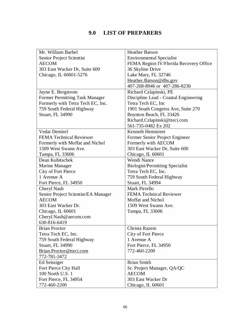
66
9.0 LIST OF PREPARERS
Mr. William BarbelSenior Project ScientistAECOM303 East Wacker Dr, Suite 600Chicago, IL 60601-5276
Heather BatsonEnvironmental SpecialistFEMA Region IV/Florida Recovery Office36 Skyline DriveLake Mary, FL [email protected] or 407-286-8236
Jayne E. BergstromFormer Permitting Task ManagerFormerly with Tetra Tech EC, Inc.759 South Federal HighwayStuart, FL 34990
Richard Czlapinski, PEDiscipline Lead - Coastal EngineeringTetra Tech EC, Inc1901 South Congress Ave, Suite 270Boynton Beach, FL [email protected] Ex 202
Vedat DemirelFEMA Technical ReviewerFormerly with Moffat and Nichol1509 West Swann Ave.Tampa, FL 33606
Kenneth HemstreetFormer Senior Project EngineerFormerly with AECOM303 East Wacker Dr, Suite 600Chicago, IL 60601
Dean KubitschekMarine ManagerCity of Fort Pierce1 Avenue AFort Pierce, FL 34950
Wendi NanceBiologist/Permitting SpecialistTetra Tech EC, Inc.759 South Federal HighwayStuart, FL 34994
Cheryl NashSenior Project Scientist/EA ManagerAECOM303 East Wacker Dr.Chicago, IL [email protected]
Mark PirrelloFEMA Technical ReviewerMoffat and Nichol1509 West Swann Ave.Tampa, FL 33606
Brian ProctorTetra Tech EC, Inc.759 South Federal HighwayStuart, FL [email protected]
Christa RazemCity of Fort Pierce1 Avenue AFort Pierce, FL 34950772-460-2200
Ed SeissigerFort Pierce City Hall100 North U.S. 1Fort Pierce, FL 34954772-460-2200
Brian SmithSr. Project Manager, QA/QCAECOM303 East Wacker DrChicago, IL 60601


![Ft. Pierce News. (Fort Pierce, Florida) 1910-01-14 [p ].ufdcimages.uflib.ufl.edu/UF/00/07/59/02/00108/00843.pdfchord BILK lft CorDe north luny above lands and ll00-H Lucie made hang](https://img.pdfslide.net/doc/110x75/5e2c3e705739104c6a5185e6/ft-pierce-news-fort-pierce-florida-1910-01-14-p-chord-bilk-lft-corde-north.jpg)