Embed Size (px)
Citation preview


1 | P a g e
TableofContentsFigures ................................................................................................................................................. 3
Tables .................................................................................................................................................. 5
Executive Summary ............................................................................................................................. 6
Introduction ......................................................................................................................................... 8
The Importance of Forests to the Two Rivers‐Ottauquechee Region ...................................................... 8
The Two Rivers‐Ottauquechee Forest Stewardship Steering Committee ................................................ 8
Objectives .......................................................................................................................................... 10
Two Rivers‐Ottauquechee Regional Characteristics ............................................................................ 11
Land Use .................................................................................................................................................. 11
Demographics ......................................................................................................................................... 11
Economic Conditions ............................................................................................................................... 12
Regional Forest Characteristics ............................................................................................................... 13
Existing Forest‐Based Land Uses ............................................................................................................. 14
Forest Resource Values ...................................................................................................................... 16
Jobs ......................................................................................................................................................... 16
Forest Products ....................................................................................................................................... 21
Heritage & Identity .................................................................................................................................. 25
Ecological Values ..................................................................................................................................... 25
Recreational Opportunities ..................................................................................................................... 29
Tourism ................................................................................................................................................... 31
Education ................................................................................................................................................ 31
Well Being/Spiritual Benefits .................................................................................................................. 31
Threats and Limitations to Forest Sustainability ................................................................................. 32
Environmental, Economic & Social Concerns ......................................................................................... 32
Existing Forest Conservation Measures .............................................................................................. 38
Conserved Lands ..................................................................................................................................... 38
Regional Plan ........................................................................................................................................... 44
Local Plans and Land Use Regulations .................................................................................................... 48
Local Conservation Commissions & Other Conservation Organizations ................................................ 60
Additional Forest Stewardship Strategies ........................................................................................... 64
Ownership of Land/Development Rights ................................................................................................ 64
Use Value Appraisal (UVA) and Other Tax Incentive Programs .............................................................. 65
Strong Forest Resources Based Businesses—Economic Opportunities .................................................. 66
Education and Outreach – Private Forest Landowners .......................................................................... 67
Education and Outreach – Consulting Foresters .................................................................................... 69
Education and Outreach – Municipal Officials ........................................................................................ 70
Education and Outreach – Community ................................................................................................... 71
Other Forestry, Natural Resources & Sustainability Initiatives............................................................... 72

2 | P a g e
Conclusion ......................................................................................................................................... 74
Appendix A ........................................................................................................................................ 75
Appendix B ........................................................................................................................................ 86
Appendix C ........................................................................................................................................ 88
Appendix D ........................................................................................................................................ 90
Citations ............................................................................................................................................ 93

3 | P a g e
FiguresFigure 1: TRORC Service Region ..................................................................................................................................... 9
Figure 2: Parcel Loss, Vermont Family Forests and Vermont Natural Resources Council,
Data for 2003‐2009, Published 2010 ........................................................................................................................... 11
Figure 3: USDA Forest Service, Forest Inventory and Analysis, 2010 ........................................................................... 13
Figure 4: USDA Forest Service, Forest Inventory and Analysis, 2010 ........................................................................... 14
Figure 5: Logging (TRORC Stock Photo) ....................................................................................................................... 16
Figure 6: Forestry and Logging Employment, Quarterly Workforce Indicators (U.S. Census), 2000 – 2010 ................ 17
Figure 7: Wood Products Manufacturing Employment, Quarterly Workforce Indicators
(U.S. Census), 2000 – 2010 .......................................................................................................................................... 17
Figure 8: Forestry and Logging Wages, Quarterly Workforce Indicators (U.S. Census), 2000‐2010 ........................... 17
Figure 9: Wood Products Manufacturing Wages, Quarterly Workforce Indicators
(U.S. Census), 2000 – 2010 .......................................................................................................................................... 18
Figure 10: Orange and Windsor Counties Sawlog and Veneer Harvest Data, Vermont Forest Harvest
Reports, 2000‐2010. Note: Missing 2007 data in Orange and Windsor Counties (VT). In both
instances, graphs were completed by repeating the previous year's number. ............................................................ 18
Figure 11: Sawmills Data, Vermont Forest Harvest Reports, 2000‐2010. Note: Missing 2007 data
in Orange and Windsor Counties (VT). In both instances, graphs were completed by repeating the
previous year's number. ............................................................................................................................................... 19
Figure 12: Maple Sugaring (TRORC Stock Photo) ........................................................................................................ 21
Figure 13: Maple Syrup Production (VT), New England Agricultural Statistics, Data for 2002 & 2007,
Published 2011 ............................................................................................................................................................. 21
Figure 14: Maple Syrup Taps (VT), New England Agricultural Statistics, Data for 1997, 2002 & 2007,
Published 2011 ............................................................................................................................................................. 21
Figure 15: Sugarmakers, New England Agricultural Statistics, Data for 1997, 2002 & 2007,
Published 2011 ............................................................................................................................................................. 22
Figure 16: Maple Syrup Production by County (VT), New England Agricultural Statistics,
Data for 2002 & 2007, Published 2011 ........................................................................................................................ 22
Figure 17: Maple Syrup Taps by County (VT), New England Agricultural Statistics,
Data for 1997, 2002 & 2007, Published 2011 .............................................................................................................. 23
Figure 18: Orange and Windsor Counties (VT), Christmas Trees – Acres in Production, Data for 2002‐2007 ............. 23
Figure 19: Orange and Windsor Counties (VT), Cut Christmas Trees Harvested, Data for 2002‐2007 ........................ 23
Figure 20: All Counties (VT), Christmas Trees Acres in Production, New England Agricultural Statistics,
Data for 2002 & 2007 .................................................................................................................................................. 24
Figure 21: All Counties (VT), Cut Christmas Trees Harvested, New England Agricultural Statistics,
Data for 2002 & 2007 .................................................................................................................................................. 24
Figure 22: Autumn in the Two Rivers‐Ottauquechee region (TRORC Stock Photo) ...................................................... 25
Figure 23: Hiking (TRORC Stock Photo) ........................................................................................................................ 29
Figure 24: Snowmobiling (TRORC Stock Photo) ........................................................................................................... 29
Figure 25: Mountain Sunset (TRORC Stock Photo) ...................................................................................................... 31
Figure 26: Wood Flows, North East State Foresters Association, Data for 2005, Published 2007 ............................... 33
Figure 27: Vermont Towns with Municipal Forests, Northern Forest Alliance ............................................................ 40
Figure 28: Conserved Lands, Upper Valley Land Trust, 2012 ....................................................................................... 60

4 | P a g e
Figure 29: Conserved Lands, Vermont Land Trust, 2012 ............................................................................................. 61
Figure 30: Priority Forest Areas, Two Rivers‐Ottauquechee Forest Stewardship Steering Committee, 2012 .............. 64
Figure 31: The Naked Table Project at Shackleton Thomas ......................................................................................... 71
Figure 32: Naked Table Project ‐ Certificate of Completion (TRORC Stock Photo) ....................................................... 72

5 | P a g e
TablesTable 1: Forest Productivity and Timber Resources Map ............................................................................................. 20
Table 2: Forest Habitat Blocks Map ............................................................................................................................. 26
Table 3: Forest Ecological Resources Map ................................................................................................................... 27
Table 4: Forest Water Resources Map ......................................................................................................................... 28
Table 5: Forest Recreational and Local Resources Map............................................................................................... 30
Table 6: Forest Resource Constraints ‐ Human and Environmental Map .................................................................... 35
Table 7: Use‐Value Appraisal Parcels and Conserved Lands Map ............................................................................... 38
Table 8: Forest Stewardship Potential Map ................................................................................................................. 43

6 | P a g e
ExecutiveSummaryMore than 70 percent of Vermont’s 4.6 million acres of forest land is classified as “nonindustrial private
forest land” (NIPF).1 Currently, NIPF is divided among approximately 88,000 landowners who
independently manage those properties according to their individual interests.2 The fragmented nature
of Vermont’s NIPF means that forest resource planning occurs at the individual parcel level, which is not
the most effective level. The State of Vermont has identified a need to keep forest land intact to ensure
habitat connectivity, forest health and productivity, ecosystem protection, and sustainability of forest
products. Consequentially, it is imperative to the long‐lasting health of the forest ecosystem that these
private forests be managed wisely. The landscape stewardship approach evolved as a way to more
effectively reach private forest landowners in order to keep forests healthy and viable. Supporting a
regionally‐integrated forest stewardship approach is a critical step in ensuring Vermont’s public and
privately owned forests are managed in an environmentally responsible way.
This project, Landscape‐Based Forest Stewardship Planning ‐ A Regional Approach, developed a
methodology for forest planning based on a landscape‐scale analysis, in order to increase the scale and
pace of sustainable management of private forest lands in Vermont, with the ultimate goal of keeping
forests as forests. This project was a collaboration between the Vermont Division of Forests and four
Vermont regional planning commissions to apply a single system – using geographic information system
(GIS) technology and a stakeholder engagement process – to inventory and assess forest resources,
identify specific forest landscape types, and produce strategies that will assist regions, municipalities,
and landowners in the objective of keeping forests as forests. The Regional Planning Commissions
involved in the project were Addison, Bennington, Lamoille and Two Rivers‐Ottauquechee; Lamoille
County Planning Commission was responsible for the overall coordination of the project.
The state assessment recently completed by the Division of Forests was combined with research
conducted in Vermont utilizing forest block and ecological landscape unit analysis and existing GIS data
to provide a consistent approach to regional forest planning. Vast rural forest blocks, large and small
lowland forest tracts, urban and community forests, and ecologically significant landscape types were all
analyzed. The objective was to identify landscape types in each region, engage stakeholders in
identifying priority forest landscapes and issues, and develop model forest plans for use by
municipalities and landowners.
Each region produced maps that characterize the forest resources in their areas and, based on an
analysis of that spatial data, developed descriptions of forest landscape types that provided the basis for
subsequent planning. The following GIS layers were used to help characterize significant forest
landscapes: land cover, elevation, soil productivity, water resources (e.g., streams, rivers, headwaters,
lakes, ponds, wetlands, groundwater protection areas), wildlife habitats, rare and endangered species
sites, unique natural areas, roads, recreation areas, sites, and trails, regional and town land use districts,
conserved lands, and Use Value Appraisal parcels where available. In addition, data derived from recent
landscape‐scale forest research in Vermont was used to help delineate priority forest landscapes.

7 | P a g e
Landscape types covered a range of conditions from large tracts of remote and mountain forest to large
and small lowland forest tracts, as well as urban and community forests, and ecologically significant
forest landscapes.
To effectively represent the interests of all involved parties, this project required collaboration between
federal, state, local, and private entities. Four regional stakeholder groups were established to guide
local efforts. Stakeholder participants included county foresters, state lands specialists, private forest
landowners, consulting foresters, local officials, representatives of forest product industries,
environmental/conservation groups, and the Green Mountain National Forest. Each region convened a
series of public/stakeholder work sessions to review and discuss the forest landscape maps and data and
to identify issues relevant to each. Additionally, staff from all four Regional Planning Commissions came
together regularly to discuss progress and address issues and challenges as they arose, and regular
meetings were held with the state and federal partners to facilitate overall coordination of the project.
The project resulted in regional, landscape‐scale forest stewardship plans that will be used by the
Division of Forests, local decision makers and forest landowners to increase the scale and pace of
sustainable management of private forest lands in Vermont. The following outcomes were
accomplished:
1) Develop and test a GIS‐based methodology for forest planning based on a landscape‐scale;
2) Engage local and regional stakeholders in the process to ensure that local issues are addressed;
3) Identify strategies and develop tools for regions, municipalities, and forest landowners to keep
forests as forests;
4) Develop a process that can be replicated across regions and landscape scales;
5) Model a collaborative process across regions and agencies for forest stewardship planning.
Many issues that were identified through the geographic analysis and stakeholder engagement process
were universal among the four regions: forests are valued for their ecological, economic, recreational,
scenic and cultural richness; forest resources are threatened by increasing fragmentation, unfavorable
economic conditions, and environmental factors such as climate change, invasive species and disease.
Yet, contrasts were revealed between the four regions with respect to landscape types, economic and
demographic conditions, and cultural/social values that resulted in priorities and strategies unique to
each region. The resulting Forest Stewardship Plans reflect regional priorities and set the stage for
future implementation of regional forest stewardship projects. Consequentially, the outcome of this
effort should not be considered an end in itself, but a means toward the overall goal of achieving
landscape forest stewardship in these four regions and beyond.

8 | P a g e
Introduction
TheImportanceofForeststotheTwoRivers‐OttauquecheeRegionForests, in one form or another, dominate the landscape in the Two Rivers‐Ottauquechee (TRO) region.
They have been an important driver in the historical development of the area, provide crucial resources
today, and will continue to be a critical asset in the development of a prosperous and sustainable future.
In spite of the prominent role that forests play in our communities, they are often overlooked or
afforded minimal discussion in Town Plans, usually lumped into an all‐encompassing ‘Natural Resources’
section. With this project, the Two Rivers‐Ottauquechee Regional Commission (TRORC) sought to give
our forest resources the attention they deserve by employing a “landscape stewardship” approach to
planning for their continued vitality.
The purpose of landscape stewardship planning is to foster a comprehensive understanding of existing
forest resources and then develop strategies that will support the overarching goal of “keeping forests
as forests.” The first step in this process is to recognize that forests exist in a variety of different
landscape settings. For instance, this region is home to many vast unbroken forested ridgelines in the
Green Mountain National Forest, as well as several large blocks of conserved forested areas like the
Chateauguay No Town Conservation Project. At the same time, the wooded banks of the White and
Ottauquechee Rivers, smaller woodlots interspersed with farmland in rural valleys, and forested parcels
in and around villages and downtown centers represent significant forest resources that are equally
important, yet are valued for different reasons.
A critical component to landscape stewardship planning is recognizing the variety of interest groups and
viewpoints that have a stake in this region’s forests. An effective planning process must involve those
stakeholders and incorporate the diversity of values and opinions represented. To this end, the TRO
Forest Stewardship Steering Committee was created.
TheTwoRivers‐Ottauquechee(TRO)ForestStewardshipSteeringCommitteeThe TRO Forest Stewardship Steering Committee was comprised of individuals from across the region,
all of whom are currently involved in forest‐related work. The committee met several times between
2011 and 2012 to discuss what barriers our region faces in maintaining forested lands and what kinds of
strategies we will need to enhance and sustain their health. The committee was comprised of:
Name Organization
Jon Bouton Windsor County Forester
Chris Casey Green Mountain & Finger Lakes National Forest
Pete Fellows Two Rivers‐Ottauquechee Regional Commission
Ehrhard Frost Full Circle Forestry & Forest Guild
Tii McLane Redstart Consulting; Linking Lands Alliance

9 | P a g e
Tom Platner Barnard Conservation Commission; Chateauguay No Town (CNT)
Conservation Project
Mary Russ White River Partnership
Carl Russell Russell Forestry Services
Elise Tillinghast Coverts
Abbey Willard (*Later replaced by
Samantha Clough)
White River Natural Resources Conservation District
Emma Zavez Two Rivers‐Ottauquechee Regional Commission
TRORC had two key staff members assigned to this project: Pete Fellows (Geographic Information
Systems or GIS Manager) and Emma Zavez (Land Use Planner). Fellows primarily focused on developing
the landscape‐scale forest maps while Zavez drafted and finalized this report. Both worked with the TRO
Forest Stewardship Steering Committee.
TRORC provides land use planning services to its thirty member municipalities, which includes towns in
Orange, Windsor, Addison, and Rutland counties. TRORC’s primary goal is to advocate for the needs of
its member towns, and to articulate a vision for building a thriving regional economy while enhancing
the region’s quality of life.
Figure 1: TRORC Service Region

10 | P a g e
ObjectivesThis project focused on three key objectives:
1) Identify Key Forest Resources and Constraints
This report details the forest resources found in the Two Rivers‐Ottauquechee (TRO) region and
presents an overview of prevailing land use patterns, including the type and extent of existing
forest‐based land uses. The compilation and assessment of forest resource values was based on
information derived from consultation with the TRO Forest Stewardship Steering Committee and
existing local and state plans. The mapping of these resource values on a regional scale represents a
departure from past efforts related to forest stewardship: in general, forest resources have either been
mapped at the state level (which is usually too coarse to highlight important regional issues) or at the
parcel level (which fails to capture the political and geographic cross‐boundary context in which these
resources exist). This project was based on the belief that mapping and analysis at the regional level is
optimal for forest stewardship planning.
2) Support and Enhance Important Regional Forest Values
Residents of the TRO region value forests for many reasons: for their contribution to job creation
(whether in the forest products or tourism industries), for their special role in Vermonters’ heritage and
identity, for their ecological benefits (such as flood control and wildlife habitat), and for myriad other
reasons. With this project, TRORC sought to strike a balance between sometimes competing values: a
balance that would satisfy the needs of various stakeholders, as well as strengthen the long‐term health
of the region’s forests and the communities that depend on them.
3) Develop Strategies to “Keep Forests as Forests”
“Keeping forests as forests” does not mean that forests and their various uses in the TRO region will not,
or should not, change over time: a forested landscape is a dynamic system that is constantly changing.
Rather, “keeping forests as forests” means proactively addressing the challenges and limitations to
sound forest management so that this region’s forests may continue to support the very reasons that
our communities value them. Such strategies are located in the final section of this report.

11 | P a g e
TwoRivers‐OttauquecheeRegionalCharacteristics
LandUseTraditionally, the Two Rivers‐Ottauquechee (TRO) region was characterized by clusters of residences
near small villages, surrounded by rural stretches of farm and forestlands. Over the past few decades,
however, commercial and residential sprawl has increased, causing a decline in the open space
necessary to support working forests and farms.
According to an in‐depth state‐wide study, the number of parcels containing more than fifty acres of
‘woodland’ (undeveloped land with relatively intact forest) has decreased in Vermont by four percent
(4%) between 2003 and 2009.3 This percentage of loss might seem insignificant at first; however, the
changes wrought over time could be monumental if unchecked. Consider these statistics4:
Percent of Loss in Parcels Greater Than
50 Acres between 2003 and 2009 Two Rivers‐Ottauquechee Towns
0% Bridgewater, Fairlee, Hartland, Pomfret, Rochester,
Stockbridge, Topsham, Woodstock
1% Barnard, Bethel, Bradford, Braintree, Corinth, Granville,
Norwich, Pittsfield, Plymouth, Sharon, Strafford, Thetford
2% Chelsea, Hancock, Newbury, West Fairlee
3% or more Brookfield, Hartford, Randolph, Royalton, Tunbridge,
Vershire
Figure 2: Parcel Loss, Vermont Family Forests and Vermont Natural Resources Council, Data for 2003‐2009, Published 2010
DemographicsIn 2010, the U.S. Census counted 55,996 people spread among TRORC’s thirty towns, which range in size
from approximately 300 to just under 10,000 people. The region’s population grew by 8.2% between the
years 1990 and 2000, after which the trend flattened (the population grew less than 1% between 2000
and 2010).
Even though population growth has eased, demand on the area’s land based resources has not.
Between 2000 and 2010, the number of housing units increased from 28,822 to 31,486 units, or 9%.5
The increase in housing units is partly attributable to the second home market in Vermont; many towns
in the TRO area are impacted by this phenomenon. Additionally, due to the global market which has
made large supermarkets the norm and outsourced value added wood products, land no longer retains
a high value for its potential productivity (as farm or forest land). Instead, the highest economic return
on a parcel is usually to be found in development.

12 | P a g e
EconomicConditionsOverall, the “annual contribution of forest‐based manufacturing and forest‐related recreation and
tourism to the Vermont economy is over $1.5 billion.”6 Indeed, it’s estimated that 6,379 Vermonters are
employed in forest‐based manufacturing, while approximately 13,000 people are thought to be working
in some type of forest related profession (manufacturing, tourism, and recreation).7
According to the American Community Survey (taken during a period between 2005 and 2009), the
major employment sectors in the TRO region are ‘educational services, and health care and social
assistance’ (29% of the total employed workforce), retail trade (11%), construction (9%), and
‘professional, scientific, management, administrative & waste management services’ (9%).8
The same survey found that only 4% of the employed population worked in ‘agriculture, forestry, fishing
and hunting, and mining.’ Nevertheless, there are several major employers in the TRO region that rely
on forestlands, including Copeland Furniture in Bradford and Pompanoosuc Mills Corporation in
Thetford, both of which employ between 100 and 249 people. Additionally, many Vermonters are
engaged in smaller ventures that involve backyard sawmills, maple syrup production, crafting furniture
or art out of locally harvested wood, and growing and selling Christmas trees. A sampling of smaller
forest‐related businesses includes:
Britton Lumber (Fairlee);
Shackleton Thomas (Bridgewater);
Lumberjack Lumber (White River Junction);
Redstart Forestry (Corinth);
Baker Lumber Co. (White River Junction);
David Hurwitz Originals (Randolph);
GMC Hardwoods Inc. (Norwich).
While many forest products are made and sold in the TRO region, Forest Stewardship Committee
members noted the lack of consumer interest. This absence exists is in marked contrast to the ‘buy local’
or ‘locavore’ movement which encourages consumers to buy locally grown vegetables and locally raised
meat, and has enjoyed huge success in Vermont.
This region’s economic and housing infrastructure pattern has contributed to the fragmentation of
forestland over the years as a network of roads has been built and maintained to facilitate the common
practice of living and working in two separate towns. For instance, the American Community Survey
(2005 – 2009) reported that 87% of those employed and sixteen years in age or older in the TRO region
drove to work, with an average commute time of 26 minutes, and the majority drove alone (rather than
carpooled).9

13 | P a g e
RegionalForestCharacteristicsBiophysical Context
Vermont is one of the most heavily forested states with 4.6 million acres or 75% of its lands covered in
trees. The TRO region is also heavily forested, sitting within the larger forest corridor of the North East,
which contains the Green Mountains (running down the spine of Vermont), the Adirondack Mountains
(in eastern New York), and the White Mountains (in western New Hampshire). Accordingly, two famous
hiking trails run through the TRO area: the Long Trail (which stretches from the northern to southern
border of Vermont), and the Appalachian National Scenic Trail (or ‘Appalachian Trail,’ which cuts a path
between Georgia and Maine).
Land Cover
In the year 2010, an analysis by the U.S. Department of Agriculture’s Forest Service found that the
current forested land cover in the TRO region is relatively similar to that in the rest of the state, with a
few minor differences. For example, the predominant forest type across Vermont is characterized as
Maple/Beech/Birch, which accounts for 71% of the state’s forested areas. In the TRO region, only 59% of
the forested area in Orange County is in Maple/Beech/Birch compared to 77% of the forest lands in
Windsor County.
Both Windsor and Orange Counties (where the majority of TRO towns are located) have very little
Oak/Pine; this forest type exists in other areas of Vermont, but barely (representing only 2% of the
forest cover across the state). Additionally, while Windsor County is relatively similar to the rest of the
state in terms of White/Red/Jack Pine, Orange County has a significantly higher concentration (27% of
its forested area). To compare the forested areas of both Orange and Windsor County to the rest of the
state in 2010, please examine the graphs below.
Figure 3: USDA Forest Service, Forest Inventory and Analysis, 2010

14 | P a g e
Figure 4: USDA Forest Service, Forest Inventory and Analysis, 2010
ExistingForest‐BasedLandUsesThere are a host of forest‐based land uses in the TRO region. Forest lands are harvested for primary
manufacturing (processing logs into lumber, veneer, pulp, or paper) and secondary manufacturing (the
creation of finished products, like furniture).10 Additionally, our maple trees are integral to maple
sugaring (maple syrup and candies are produced either for hobby or profession), and conifer trees are
grown and cut for sale at Christmas time. TRO forests also provide a place to forage wild edibles, like
mushrooms and fiddleheads. And, recreational opportunities abound; many Vermonters and tourists
alike love to go camping, hiking, snow‐shoeing, and skiing. While Vermont is well known for its downhill
ski resorts, such as Suicide Six in Woodstock, the woods are also home to numerous cross country trails,
such as those at the Strafford Nordic Center or, alternately, informal networks of trails sometimes
managed by a single private landowner or a group of neighbors. Other Vermonters prefer to
snowmobile in forested backyards and on established trails. And, many residents and tourists alike seek
spiritual or personal growth and fulfillment from our forests—as places of beauty (especially in the
autumn months) and ecological integrity. Accordingly, many tourists seek out the scenic vistas in
Vermont and look for wildlife on nature walks or birding tours.
Existing forest‐based land uses will carry on in the future, with a few exceptions. As the climate
continues to change, Vermonters will notice a shift in weather patterns that may render some
traditional forest‐based land uses (like skiing and maple sugaring) obsolete. For instance, warmer
temperatures and an accelerated freeze‐thaw cycle in winter and spring 2012 forced the closure of
many ski trails and an early end to the season for many resorts. Additionally, the 2012 maple sugaring
season began and ended earlier, with many Upper Valley operations reporting drastic declines in
production.11 According to the New England Regional Assessment conducted for the University of New
Hampshire in 2001:

15 | P a g e
…species migration due to a changing climate may well be the most
devastating impact to affect regional forests. The climate models predict
that by 2100 the major components of the New England forests will be
oak and hickory... The brilliant reds, oranges, and yellows of the maples,
birches, and beeches may be replaced in the landscape by the browns
and dull greens of oaks.12
These changes would herald an end to Vermont’s tradition of maple sugaring and alter the visual
aesthetic of the state, which has been crucial for tourism.
Although some of this region’s key forest based land uses will disappear in future decades, new uses will
emerge. For instance, as Vermont increases the percent of renewable resources in its energy portfolio,
landowners may see increasing demand for biomass (an energy source derived from plant material), as
well as carbon sequestration projects (a carbon dioxide mitigation technique, premised on trees’
capacity to store carbon).
16 | P a g e
ForestResourceValues
During a series of discussions, members of the Two Rivers‐Ottauquechee (TRO) Forest Stewardship
Committee spoke about why they value forests in this region. Many values emerged; however they are
not ranked in any particular order below.
A quick disclaimer regarding the forthcoming graphs and statistics cited in this section: Most are
premised on an analysis of Orange and Windsor Counties where the majority of TRO towns are located
(27 of 30 towns). In reality, TRO towns are spread out over four counties (Orange, Windsor, Addison,
and Rutland); however, since data is often gathered by the federal and state governments at the county
level only, an analysis of Orange and Windsor Counties was deemed the best option for presenting a
close approximation (rather than an exact accounting) of forest resources in the TRO region.
JobsForestlands are important because they provide residents with the opportunity for locally based
employment that has the potential to be sustainable, as long as good forest management practices are
utilized. Residents of this region work in primary and secondary forest related jobs. For instance, there
are employment opportunities to be found working on state or national lands, as a private or public (i.e.
county) forester, in trades such as construction or furniture making, and more.
The Quarterly Workforce Indicators (QWI)
from the U.S. Census presents employment
and salary statistics for Vermont’s forest
industry. The QWI counts jobs, rather than
employed workers and does not include
self‐employed workers and independent
contractor employment. In the graphs below,
one can see that employment in Orange and
Windsor Counties has remained relatively
steady for forestry and logging, ending with
more jobs in the fourth quarter of the year
2010 than in the year 2000. While state‐wide
employment in wood products manufacturing
has fallen significantly, jobs have remained at
relatively steady levels in Orange and Windsor Counties.
Figure 5: Logging (TRORC Stock Photo)

17 | P a g e
Figure 6: Forestry and Logging Employment, Quarterly Workforce Indicators (U.S. Census), 2000 – 2010 Figure 7: Wood Products Manufacturing Employment, Quarterly Workforce Indicators (U.S. Census), 2000 – 2010
In regard to forestry and logging wages, the average for Vermont was higher than that for Orange and
Windsor Counties throughout most of the decade (2000‐2010); however, in 2010, Orange County
offered higher wages than the Vermont average, while Windsor County offered lower.
Figure 8: Forestry and Logging Wages, Quarterly Workforce Indicators (U.S. Census), 2000‐2010

18 | P a g e
Both Windsor and Orange Counties had lower wood products manufacturing wages when compared to
the state average in 2010.
Figure 9: Wood Products Manufacturing Wages, Quarterly Workforce Indicators (U.S. Census), 2000 – 2010
One of the traditional employment opportunities is in timber harvesting. The graphs (below) reflect the
sawlog and veneer harvest between the years of 2000 and 2010 for Orange and Windsor Counties.
While both the hardwood and softwood harvest have remained relatively steady in Orange County over
the last decade, a more precipitous rise and fall have characterized their trajectory in Windsor County.
Both counties, it is important to note, are producing about the same amount of hardwood and softwood
in 2010 that they began with in 2000 (the one exception being hardwood in Windsor County, with
production down in in 2010).
Figure 10: Orange and Windsor Counties Sawlog and Veneer Harvest Data, Vermont Forest Harvest Reports, 2000‐2010. Note: Missing 2007 data in Orange and Windsor Counties (VT). In both instances, graphs were completed by repeating the previous year's number.
Over the last decade, Windsor County has consistently housed more sawmills than Orange County;
however, there is a decline in the number of sawmills in both counties, with fewer existing in 2010 than

19 | P a g e
in 2000. The lack of sawmills in this region is of concern as it forces timber harvests to be shipped
elsewhere in the state (or, more often, out of state) to be processed. This results in lost revenue for our
residents, can minimize the opportunity to create value added wood products, and increases the
‘carbon footprint’ of an operation (due to the fuel burned during transportation).
Figure 11: Sawmills Data, Vermont Forest Harvest Reports, 2000‐2010. Note: Missing 2007 data in Orange and Windsor Counties (VT). In both instances, graphs were completed by repeating the previous year's number.
The next map illustrates areas of high and low forest productivity and timber resources. One can see the
correlation between lower productivity and higher elevations (generally, the soil depths and quality are
lower). These are the traditional heavily forested uplands, including those in the Green Mountain
National Forest.
Higher productivity forest lands are concentrated in the center and on the eastern side of the TRO
region. Forest blocks have had difficulty surviving in these areas because of the rich soils (which are ideal
for agriculture) and proximity to large population centers (which are subject to development pressure).

20 | P a g e
Table 1: Forest Productivity and Timber Resources Map

21 | P a g e
ForestProductsRather than import forest products from afar, Vermonters are proud to manufacture some of these
goods in their backyard.
Maple Syrup
Like most places in Vermont, the maple
syrup industry is important to the
economy in the TRO region. While more
syrup is produced in Windsor than in
Orange County, both areas have
experienced a decline in production
between 2002 and 2007, as illustrated in
the graphs below. In Windsor County, this
decline in production is in spite of
increases in the number of trees tapped
between 1997 and 2007. A decline in the
number of trees tapped in Orange County
between 2002 and 2007 may explain the
decrease in syrup production. Both
Windsor and Orange Counties have experienced a decline in the number of sugarmakers between the
years 2002 and 2007.
Figure 13: Maple Syrup Production (VT), New England Agricultural Statistics, Data for 2002 & 2007, Published 2011 Figure 14: Maple Syrup Taps (VT), New England Agricultural Statistics, Data for 1997, 2002 & 2007, Published 2011
Figure 12: Maple Sugaring (TRORC Stock Photo)

22 | P a g e
Figure 15: Sugarmakers, New England Agricultural Statistics, Data for 1997, 2002 & 2007, Published 2011
Windsor and Orange Counties do not produce nearly as much syrup as Franklin County (which made
close to 190,000 gallons in 2007); however, the profession remains important here.
Figure 16: Maple Syrup Production by County (VT), New England Agricultural Statistics, Data for 2002 & 2007, Published 2011

23 | P a g e
Figure 17: Maple Syrup Taps by County (VT), New England Agricultural Statistics, Data for 1997, 2002 & 2007, Published 2011
Christmas Trees
Christmas trees are another significant forest related product in the TRO region. In terms of the number
of acres harvested, both Windsor and Orange Counties experienced a decline between the years 2002
and 2007; however, in terms of the number of trees harvested, Windsor County experienced a slight
increase (from 15,332 trees in 2002 to 15,180 in 2007).
Figure 18: Orange and Windsor Counties (VT), Christmas Trees – Acres in Production, Data for 2002‐2007 Figure 19: Orange and Windsor Counties (VT), Cut Christmas Trees Harvested, Data for 2002‐2007
Relative to the rest of the state, Orange County is less active in the Christmas tree harvest (whether
measured by acre or number of trees), while Windsor County’s production is close to that of the top
contenders in the market.

24 | P a g e
Figure 20: All Counties (VT), Christmas Trees Acres in Production, New England Agricultural Statistics, Data for 2002 & 2007
Figure 21: All Counties (VT), Cut Christmas Trees Harvested, New England Agricultural Statistics, Data for 2002 & 2007
25 | P a g e
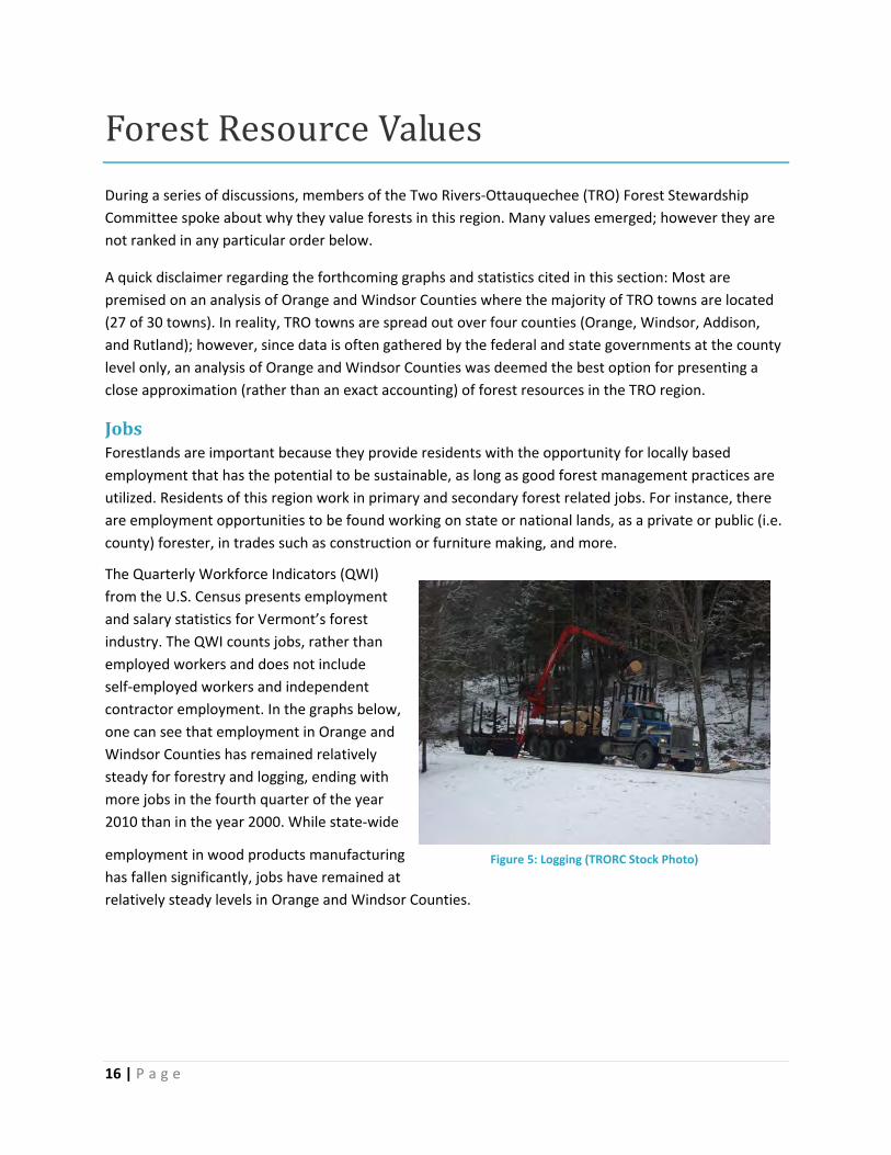
Heritage&IdentityWhen one thinks of
Vermont, the forested
landscape comes to mind
instantly: the lush green
hills (hence ‘the Green
Mountain State’) or the
splash of orange, red, and
yellow which explodes and
then fades during the
autumn months. As a
defining physical feature of
the landscape, forests have
become embedded in
Vermonters’ heritage and
identity. Residents of the
TRO region are no different:
visual and physical
manifestations of forests
abound in our day‐to‐day
lives.
EcologicalValuesForests provide critical
wildlife habitat as exhibited
in the following maps. The
first map (‘Forest Habitat
Blocks’) shows an
assessment of the TRO
region based on a low to
high priority ranking system
for habitat potential. The
‘habitat potential’ layer
uses several weighting
factors that include block size, characteristics, and block ecology. In general, larger blocks are better but
some small to medium sized blocks with excellent ecological characteristics are ranked high. The map
also shows lands that have been conserved by The Nature Conservancy (TNC).
Figure 22: Autumn in the Two Rivers‐Ottauquechee region (TRORC Stock Photo)

26 | P a g e
Table 2: Forest Habitat Blocks Map

27 | P a g e
The next map shows ranked forest habitat blocks alongside natural communities, deeryards, and
wetlands. One can also see the regional conflict between settled river valleys (which contain roads and
other infrastructure) and the deer and other large animals, as indicated by animal‐car collision statistics.
Table 3: Forest Ecological Resources Map

28 | P a g e
The next map shows the different watersheds in this region and corresponding water based features.
The river valleys offer habitat and are a good water source; however, they also pose flooding and
erosion risks as forcefully demonstrated by Tropical Storm Irene in August 2011.
Table 4: Forest Water Resources Map

29 | P a g e
RecreationalOpportunities Forests in the TRO region are valued for the
recreational opportunities they provide, such as
walking, hiking, biking, camping, and skiing.
Outdoor recreation is commonly associated with
the Vermont ‘way of life’ and is a reason that many
residents choose to live here and tourists decide to
visit. By providing recreational opportunities,
forests contribute to residents’ physical health and
happiness.
On the next map, one can glimpse the abundance of
formal recreational sites in the TRO region. For
instance, the Appalachian and Long Trails both
intersect this area, providing ample opportunity for
hiking and camping. Additionally, the TRO region is
home to the Green Mountain National Forest,
Coolidge State Forest, and several state parks in
Brookfield, Thetford, Hartford, Barnard and
Plymouth. There are also many privately conserved
lands that are open to the public for recreation.
Figure 24: Snowmobiling (TRORC Stock Photo)
Figure 23: Hiking (TRORC Stock Photo)

30 | P a g e
Table 5: Forest Recreational and Local Resources Map

31 | P a g e
TourismThe TRO Forest Stewardship Committee values forests for the important role they play in the tourism
industry. In the summer months, forested areas contribute to the ‘green’ mountain appeal of Vermont,
while in the fall, maple trees color the landscape. The landscape is visually appealing to tourists, drawing
visitors during all seasons, but especially in the autumn. Forests in the TRO region are also critical to
maple syrup and candy production and recreational opportunities. As a result, forests indirectly support
establishments that are dependent on visitors, like hotels, bed and breakfasts, restaurants and gift
shops.
EducationForests are valued because they provide the setting for place‐based learning as kids explore the sciences
in school, at camp, and with their families and friends. For instance, the TRO region is home to Farm &
Wilderness, an intensive outdoor summer camp for youth, as well as the Vermont Institute of Natural
Science, and many Vermont Youth Conservation Corps projects which employ teenagers in conservation
work.
WellBeing/SpiritualBenefitsAmericans have a tradition of seeking solace in the woods as demonstrated by great writers like Henry
David Thoreau (author of Walden) or John Muir (author of My First Summer in the Sierra). TRO residents
are no different—they enjoy forests for various reasons, whether the trees bring them joy, happiness, or
peace of mind.
Figure 25: Mountain Sunset (TRORC Stock Photo)

32 | P a g e
ThreatsandLimitationstoForestSustainability
Environmental,Economic&SocialConcernsThe Two Rivers‐Ottauquechee (TRO) Forest Stewardship Committee perceives a number of threats to
maintaining forests as forests in this region. The first, second, and third concerns were identified as most
important.
1) Diminishing Cultural Connection to Forests
The lack of personal and cultural connection to forests and forest services/products is concerning.
Environmental Repercussions: This lack of connection is indicative of, and reinforces, the
knowledge gap between consumers and producers of forest products. Without informed and
proactive consumers, it is less likely that industry will be held accountable for their impact on
forests. Simply, if TRO residents do not value the environmental benefits of our forests and act
as stewards of this resource, degradation is inevitable.
Economic Repercussions: A lack of personal or cultural connection to forests will drive
consumers towards the lowest priced wood products, which will undercut local businesses in
favor of foreign competition.
Social Repercussions: TRO residents will begin to lose sight (literally) of their heritage, ‘the
Green Mountains.’
2) Absence of a Popular ‘Buy Local’ Movement
The lack of a ‘buy local’ forest products movement is a major obstacle to forests continued existence in
the TRO region. The absence is noteworthy when compared to the local food movement which is
thriving in Vermont and across the nation.
Environmental Repercussions: A ‘buy local’ movement would create a more direct opportunity
for consumers to demand that a business operate with a certain level of environmental
integrity.
Economic Repercussions: The lack of a ‘buy local’ movement means that consumers will be less
likely to pay extra for locally made furniture, toilet paper, and other goods. This harms the local
economy and translates into fewer jobs in the TRO region.

33 | P a g e
Social Repercussions: The absence of a ‘buy local’ movement means that individuals will not
receive the same level of support from peers when trying to make conscientious shopping
decisions.
3) Decrease in Local Wood Processing Sites
The TRO Forest Stewardship Committee is concerned that the decreasing number of manufacturing or
wood processing sites in Vermont will continue the trend of out‐of‐state shipment of raw materials.
Environmental Repercussions: With fewer locally based wood processing sites, raw materials
will have to travel greater distances before being processed and sold, increasing the industry’s
‘carbon footprint’ and contributing to global climate change.
Economic Repercussions:
Shipping raw materials out‐of‐
state results in the loss of
secondary manufacturing jobs
and the eventual deskilling of
the TRO labor force in this
industry. Consider these
statistics13 from 2005:
Social Repercussions: The
decreasing number of nearby
wood processing sites
discourages locally based
partnerships in the forest
products industry. This not only
constitutes a lost economic
opportunity, but a lost social
one as well.
4) Parcelization and Fragmentation of Forest Lands
Both parcelization (the subdivision of a large parcel into several smaller ones) and fragmentation
(interruptions in otherwise intact forestlands due to infrastructure like roads or power lines) are
problems in the TRO area. According to an in‐depth state‐wide study, the number of parcels containing
more than fifty acres of ‘woodland’ (undeveloped land with relatively intact forest) has decreased in
Vermont by four percent (4%) between 2003 and 2009.14 This percentage of loss might seem
insignificant at first; however, the changes wrought over time could be monumental if unchecked. While
the TRO region has many conserved lands, most towns are still undergoing slow and steady parcelization
and fragmentation.
Figure 26: Wood Flows, North East State Foresters Association, Data for 2005, Published 2007

34 | P a g e
Environmental Repercussions: Parcelization and fragmentation threaten wildlife habitat and
interrupt travel corridors for larger species. As fragmentation increases, the number and
diversity of species that our lands can support will decrease. Parcelization reduces
environmental quality by inhibiting the earth’s natural capacity to cleanse pollutants from the
environment. For instance, more development can result in less forest cover, which can increase
runoff of pollutants into streams. Less forest cover can contribute to riverbank destabilization,
sedimentation and increases in water temperatures. All of these symptoms can result in poor
water quality.
Economic Repercussions: Once a parcel is reduced to less than 50 acres, management for forest
industries or wildlife is no longer viable.15 Additionally, forests are an important component of
Vermont’s landscape; increasing fragmentation may result in less tourism.
Social Repercussions: The working landscape of forests and farms that Vermonters and those
that visit know and love will be diminished, bringing significant changes to our culture.
The following map illustrates forest decline and housing density. Forest health has been declining across
Vermont due to acid deposition and climate change, the impacts of which can be seen across all forest
ecologies. Parcelization of forest lands is another direct threat to forest health as ecosystem size shrinks,
becoming less diverse.

35 | P a g e
Table 6: Forest Resource Constraints ‐ Human and Environmental Map

36 | P a g e
5) Disconnect Between Cause & Effect
Identifying the causes of environmental degradation is often difficult or impossible.
Environmental Repercussions: Disconnect between cause and effect enables unsound
environmental practices to continue long after they’ve begun to cause problems. A good
example is the deforestation of headwaters areas in past years, which likely led to worse
flooding damage in upland portions of the watersheds during Tropical Storm Irene in August
2011.
Economic Repercussions: The increase in environmentally induced human health problems puts
economic stress on individuals, families, businesses, and governments.
Social Repercussions: Environmentally induced human health problems put stress on the
afflicted, as well as their loved ones.
6) Invasive Species
Invasive species are on the rise in the TRO region.
Environmental Repercussions: Invasive species can challenge and overwhelm native species,
causing a ripple of consequences throughout an ecosystem. For example, Vermont’s
Department of Forests, Parks, and Recreation (FPR) is worried about the Emerald Ash Borer, a
wood‐boring insect from Asia that kills ash trees; it has already spread to the Hudson Valley in
New York and areas of Canada directly north of Vermont’s state border.16 The Hemlock Woolly
Adelgid (HWA) is another cause for concern; FPR describes the problem: “It [HWA] feeds on
young twigs, causing needles to dry out and drop prematurely. Trees may die in four to six years.
Some survive, but with sparse foliage, losing their value as shelter for wildlife and their ability to
shade streams.”17 HWA has already been sighted in Vermont’s Windham County18 and
Bennington County.19
Economic Repercussions: When an invasive species causes damage to a native species that is of
economic importance, our economy is harmed. For instance, ash trees are important to the
forest industry in Vermont because the timber is white, dense, and grows quickly. If the Emerald
Ash Borer infests Vermont, then economic consequences are certain. (So far, the insect has
killed tens of millions of trees in the eastern U.S. and Canada.)20
Social Repercussions: When traditional species are crowded out by invasive ones, people lose
part of their heritage.

37 | P a g e
7) The Economic Incentive to Develop
A private landowner can usually procure a higher return on investment by developing a forested parcel,
instead of managing it for the forest’s continued existence.
Environmental Repercussions: This value system results in more forest lands being cut or paved
for development with negative impacts on wildlife habitat and travel corridors, as well as water
quality, not to mention the loss of scenic and recreational opportunities.
Economic Repercussions: The economic incentive to develop forest lands results in unbalanced
or incomplete accounting of forest benefits to human society. For instance, forests can mitigate
the impacts of flooding, thereby saving governments and land owners huge amounts of money
by avoiding damage.
Social Repercussions: Fewer forest lands adversely affects Vermonter’s heritage and identity as
experiences change to reflect living in a ‘developed’ area instead of a wild or more rural one.
8) Lack of Social, Cultural, and Institutional Support for Careers in Forestry
Teachers and guidance counselors in primary and secondary schools don’t always encourage their
students to pursue forest or agriculture related careers.
Environmental Repercussions: The lack of support for forest related careers will result in less
attention paid to forest related subjects in our educational system, and a less informed citizenry.
Economic Repercussions: The lack of institutional support will result in an unskilled workforce
and a reduction in the number of jobs that Vermont can offer its residents. Ultimately, this may
negatively impact our tourist and wood products manufacturing sectors, and push Vermonters
to leave the state in search of employment.
Social Repercussions: Lack of awareness of forest related careers means that fewer young adults
will receive the skills necessary to work in this sector. Furthermore, the lack of educational
opportunities fosters an atmosphere of disrespect for forest related careers and the individuals
who choose to pursue this path.

38 | P a g e
ExistingForestConservationMeasures
ConservedLandsThere many different types of conserved lands in the TRO region, several of which are shown on the
following map.
Table 7: Use‐Value Appraisal Parcels and Conserved Lands Map

39 | P a g e
State Lands
The TRO region includes the large Coolidge State Forest block in the south (located in Plymouth,
Bridgewater, and Woodstock), as well as six state parks. Several larger Wildlife Management Areas
(WMAs) are scattered throughout the region, including several in Strafford and the large Les Newell
WMA in the Chateauguay area (which is spread across the towns of Barnard, Bridgewater, Sherburne,
and Stockbridge).
Federal Lands
Green Mountain National Forest (GMNF): With over 400,000 acres, the GMNF constitutes the largest
contiguous public lands area in Vermont. It is spread across central and south‐western Vermont, and is
located within several TRO towns, including Woodstock, Rochester, Hancock, Pittsfield, Stockbridge,
Granville, Bridgewater, Pomfret, Hartford, and Norwich. The lands are managed by the Vermont
Department of Agriculture’s Forest Service and one of their ranger stations is located in Rochester.21
Home to portions of the Long Trail, Appalachian Trail, and the Robert Frost National Recreation Trail, the
GMNF is a popular outdoor recreation destination.
State Lands
Arthur Davis Wildlife Management Area (WMA): The Arthur Davis WMA is a 7,788 acre parcel that
stretches between the towns of Reading and Plymouth, and abuts Coolidge State Forest and Camp
Plymouth State Park. Given that Coolidge State Forest is connected to the Plymsbury WMA, the
combination has resulted in one of the largest state‐owned forested areas in southern Vermont. The
forest lands in the Arthur Davis WMA are comprised of sugar and red maple, yellow birch, and beech
trees, with red spruce and white pine present to a lesser degree. It is home to rivers, vernal pools, and
Reading Pond, as well as wildlife like black bears, snowshoe hare, barred owls, and white tailed deer,
amongst others. While the property is owned by the State of Vermont, it is actively logged by private
parties who hold the timber rights.22
Coolidge State Forest (CSF): CSF encompasses 21,500 acres of land in Plymouth and Woodstock,
Vermont. These lands are part of Coolidge State Park where campsites, hiking trails, and beautiful scenic
views are abundant. CSF is the state’s largest landholding, and is managed by Vermont’s Department of
Forests, Parks, and Recreation (FPR).23
Les Newell Wildlife Management Area (WMA): The Les Newell WMA encompasses 7,988 acres in the
towns of Barnard, Bridgewater, Stockbridge, and Sherburne. It is part of a larger forest block which
totals 50,000 acres in the historic Chateauguay region. The forest contains red and sugar maple, yellow
birch, beech, balsam fir, hemlock, and red spruce trees. The area is owned by the State of Vermont,
managed by the Vermont Fish & Wildlife Department, and timber rights are held by the A. Johnson
Company. A segment of the Appalachian Trail traverses the area, allowing hikers to see wildlife like
moose, white‐tailed deer, black bear, ruffed grouse, beavers, and others. Hunting of ruffed grouse is
permitted in season.24

40 | P a g e
Pine Mountain Wildlife Management Area (WMA): Pine Mountain is one of the larger WMAs in the TRO
region; it spans the towns of Topsham and Newbury, as well as Groton and Ryegate (which are
technically outside of the TRO area). It is 2,274 acres in size, 95% of which is forested. Managed by the
Vermont Fish and Wildlife Department, the Pine Mountain WMA is home to white‐tailed deer, black
bear, moose, and many other mammals, birds, fish, and amphibians. The area is open for hiking, fishing,
trapping, and hunting.25
Town Forests
Owned by the local municipality,
a ‘town forest’ conserves land
while providing recreational
opportunities for the community,
wildlife habitat for plants and
animals, and sometimes revenue
for the town government
(through timber sale or sap
production). Almost half of all
Vermont towns own a
community forest. In the TRO
region, there are town forests in
West Fairlee and Fairlee,
Randolph, Royalton, Corinth, and
others as illustrated on the
following map of central and
southern Vermont.26
Brushwood Community Forest (BCF): In 2009, BCF was established on approximately 475 acres of
relatively undeveloped forest lands that span the towns of Fairlee and West Fairlee. With the help of the
Trust for Public Land, the area is now owned by the Town of West Fairlee and protected from
development through a conservation easement that is held by FPR.27 The Community Forest is just a
small segment of the ten thousand acre Brushwood Forest, which includes the 1,400 acre Fairlee
Municipal Forest. The forest boasts an extensive trail network, vast undeveloped forestlands, wetlands,
and wildlife habitat. The unprotected lands in Brushwood Forest are facing increasing residential
development pressure.28
Conservation Easements
A conservation easement (CE) is a legally binding agreement between a landowner and the government
or a local land protection organization (land trust) that ensures a parcel will be protected from certain
types of development indefinitely. CEs are typically created to conserve farm and forestlands, or other
ecologically sensitive areas, such as wildlife habitat or wetlands; however, a landowner can choose to
Figure 27: Vermont Towns with Municipal Forests, Northern Forest Alliance

41 | P a g e
conserve any of his or her parcels, regardless of ecological integrity. Indeed, many landowners conserve
areas that are of particular importance to an individual, family, or community. The parcel can be small or
large, and it is usually donated, although sometimes organizations will fundraise to purchase a parcel.
In the TRO region, many conservation easements are written, held, and enforced by either the State of
Vermont or one of the local land trusts, such as the Vermont Land Trust (VLT) or the Upper Valley Land
Trust (UVLT).
A few noteworthy projects include:
Taylor Valley: Taylor Valley is a forested area of approximately 18,000 acres that spans Chelsea,
Vershire, Tunbridge, and Strafford.29 Conserved by The Nature Conservancy, the area is managed by the
Taylor Valley Conservation Project, which includes private landholders, as well as members of the
community who want to maintain what they see as an “ecologically rich and productive area for future
generations.”30
Chateauguay No Town (CNT) Conservation Project: The CNT Conservation Project spans more than
60,000 conserved acres across the towns of Barnard, Bridgewater, and Stockbridge (in the TRO area), as
well as Killington (outside of the TRO area). Town representatives convened the project in 1997 to
encourage voluntary conservation of private lands in order to maintain current wildlife habitats, and
promote sustainable forestry and other objectives.31
Orange County Headwaters (OCH) Project: The OCH Project was started by landowners in Washington
and Corinth who were interested in conservation. Through the Vermont Land Trust and the Upper Valley
Land Trust, 31 OCH landowners have conserved 4,500 acres. Much of this land is forested.32
Private Lands & the Use Value Appraisal (UVA) Program
Ensuring the continued existence of private forestlands is a high priority of the State of Vermont, as
evidenced by the Use Value Appraisal program (to be discussed further in the “Additional Forest
Stewardship Strategies” section of this report), and the attention paid to the land’s stewardship
potential.
The Vermont Department of Forests, Parks, and Recreation (FPR) developed the Vermont Forest
Stewardship Spatial Analysis Project (SAP) to determine the potential for stewardship of private forest
lands in Vermont. Spatial data were used to indicate non‐industrial private forest lands where
stewardship could be encouraged or enhanced. Lands with high stewardship potential are considered
priority areas for the Forest Stewardship Program of the U.S. Department of Agriculture (USDA) as well
as for more concentrated conservation, management, and associated planning efforts. This project
identified 10 factors that play a key role in influencing suitability for forest stewardship. Factors that
threaten forest resources include development (conversion to non‐forest uses) and forest health (risk
and adaptability to change). Factors that support the potential of forest resources include forest
patches, slope, wildlife and biodiversity, riparian corridors, wetlands, priority watersheds, and proximity

42 | P a g e
to publicly‐owned lands. Using a GIS analysis, 30 x 30 meter grid cells were assigned values based on
each of the 10 parameters to determine their individual forest stewardship potential or threat.
Then the importance of each of these factors was ranked as high, medium or low and the results were
combined in a GIS overlay analysis. The final product is a single data layer which represents the
suitability of the land for further stewardship efforts, scored from 3 (high potential for forest
stewardship) to 1 (low potential).33
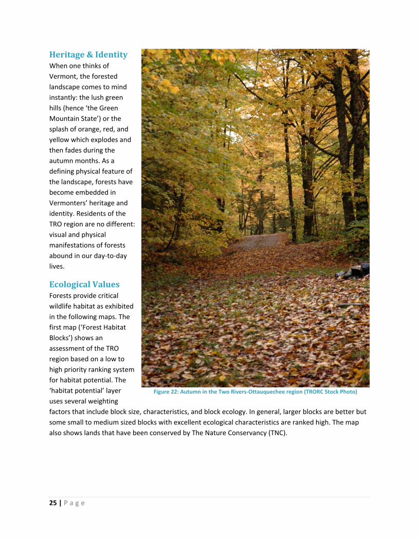
The results of SAP for the TRO region are shown in the following ‘Forest Stewardship Potential’ map.
One can see high to moderate forest potential throughout the region. Areas with high potential include
most of the White River Watershed towns of Randolph, Bethel, Royalton and Barnard, as well as the
uplands in Topsham, Newbury, and Corinth. SAP also identifies moderate or high areas of forest
potential in regions that are currently used for agriculture or adjacent to growing communities.
43 | P a g e
Table 8: Forest Stewardship Potential Map

44 | P a g e
RegionalPlanTRORC’s 2007 Regional Plan (http://www.trorc.org/pubsrp.html) contains a chapter that is dedicated to
the topics of forestry and agriculture.34 In this chapter, TRORC emphasizes the need for sustaining
forestry, not just conserving forests. Attention is paid to the economic importance of forests as a
significant source of local employment. TRORC also acknowledges threats to forests, including
parcelization and fragmentation, and the hardships imposed by tax structures that value the
development potential of a parcel over its productivity. The plan advocates for the diversification of the
forest industry as a means of survival, and supports the creation of value‐added products.
In general, the Regional Plan seeks to curb sprawl by concentrating development in ‘regional growth
centers,’ thereby protecting the character of rural areas. For instance, a few of the plan’s overarching
goals are quoted (in italics) below:
Goals
Maintain and improve the accessibility and economic viability regional growth areas;
(sic)
Protect the character of rural areas and their natural resources by avoiding sprawling
development, and incompatible land uses;
Protect the natural environment by preservation and wise use of natural resources.35
Land Use Districts
The Regional Plan divides the area into seven land use districts: Regional Centers, Town Centers, Village
Settlements, Hamlet Areas, Rural Areas, Conservation and Resource Areas, and Interchange Areas.
Among these seven, Rural Areas and Conservation & Resources Areas contain the bulk of forest lands.
Section V: Agriculture & Forestry
TRORC’s Regional Plan sets out the following goals, principles (for sustaining agriculture and forestry),
policies, and recommendations for action. Please note that these are either paraphrased (due to space
constraints) or quoted (in italics).
Goals
1) Encourage the conservation, wise use and management of the region's agricultural and
forestry resources, to maintain its environmental integrity, and to protect its unique and
fragile natural features;
2) Protect the region's rural agricultural character, scenic landscape, and recreational
resources;
3) Create and maintain an environment (physical, social, regulatory, and fiscal) that
encourages entrepreneurism in agricultural and forestry activities, including those which
add value to the region’s agricultural and forestry products;

45 | P a g e
4) Sustain agriculture and forestry in those areas of the region where they are predominant
land uses, and where soils, and other conditions enable them to remain economically
viable;
5) Support programs which educate citizens on principles of sustainability;
6) Reduce fragmentation of forest and agricultural lands.36
Principles of Sustaining Agriculture & Forestry
a) Owners of farm land and forest land should receive a fair and real return on what they
produce;
b) Owners of farmland and forestland should receive a fair return for what they provide to
the town, region and state;
c) Owners of farmland and forestland should be given an incentive and the freedom to care
for the land;
d) Whether big farms or large tracts of forest lands will be most successful is unclear.
Given this, options for conserving these resources should be varied and flexible to ensure
viability; and
e) Conservation of agriculture and forestry will involve a broad coalition of interests. To be
successful, the industry efforts will probably need to be strengthened by efforts of
tourism, rural interests, historic preservation, recreation, etc.37
Policies
1) Clustered or peripheral development is required where agricultural or forestlands are
identified;
2) Agriculture and forestry practices shall maintain or enhance the diversity of ecosystems
existing in the region;
3) Proposals for appropriately sited businesses that promote local processing of forestry or
agriculture products should not be discouraged; they are also ‘home cottage’ industries;
4) Agricultural land and forested land form the separations between town centers, villages,
and hamlets in the traditional regional settlement pattern. Tangible efforts shall be
made to preserve this patchworked balance of open and forested space, to promote
compact settlements… Contiguous forest and significant agricultural areas shall remain
largely in non‐intensive uses unless no reasonable alternative exists to provide essential
residential, commercial and industrial activities for the region’s inhabitants;
5) Support for property tax reform to reduce the cost of owning agricultural or forested
lands;
6) New infrastructure (such as utilities and roads) should skirt, rather than divide forest
lands;
7) Support for purchase of development rights by public or private funds. In determining a
conservation value for the land, one should consider the following:

46 | P a g e
Evaluation of an active farm operation, a sound financial plan for returning as a
viable farm unit, or an active forest management plan with history of planned
harvesting;
The project must conform to duly adopted regional and/or municipal plans;
The resource value of the site incorporating such factors as parcel size, soil
productivity values, and accessibility;
Threat of loss or conversion to non‐farm or forestry use;
Adequacy of existing infrastructure and public investments to serve the use;
Location of the use relative to similar uses; and
Adequacy of past resources management practices;
8) Applications or injections of septage or sewage sludge must be done in accordance with
standards set by the State of Vermont, and must be tested for harmful concentrations
of certain substances;
9) Farmers, loggers, and foresters must use Accepted Management Practices (AMP) and
are encouraged to implement Best Management Practices (BMP) in their operations and
to minimize point and non‐point source pollution;
10) Support for stream bank and shoreline buffer strips when the area is being used for
agricultural or forestry purposes. Specifically: Erosion control methods which use
vegetation and other natural materials and which protect wildlife habitat are favored
over other methods. Rip‐rapping of shorelands can be used in appropriate circumstances
to protect farmlands from erosion;
11) Acknowledgement that certain types of land development may conflict with the above
stated policies;
12) Encouragement of minimizing or mitigating loss of forestlands to development. An
alternative to conventional methods is off‐site mitigation, but such a tactic should only
be used when it is: (a) consistent with this [Regional] Plan and the plans of affected
municipalities; and (b) provides an equal or greater public benefit than conservation of
the development site itself.38
Recommendations for Action
1) Offer planning advice on sustaining agriculture and forestry to Planning Commissions,
Conservation Commissions, and non‐profit conservation organizations;
2) …Evaluate proposed developments involving primary agricultural and forest lands, and
their related industries. Where appropriate, it will provide information to federal and
state agencies, town boards and commissions, and other parties regarding the probable
impacts these resources have on the welfare of the region;
3) Local land use planning activities and programs affecting agriculture and forestry should
consider the following as ways to promote these industries:
47 | P a g e
a) Development of local plan components, including an inventory, and assessment of
farm and forest lands. Although far from satisfactory, past use of the Land
Evaluating and Site Assessment (LESA) method for identification of priority lands
has been referenced;
b) As part of local bylaws, creation of farm and forest land conservation programs,
including: agricultural zoning; area based allocation; cluster development; impact
fees; overlay districts; performance standards; purchase of development rights;
transfer of development rights;
c) Work with Vermont Housing and Conservation Board (VHCB) to acquire interests
or easements on significant agricultural or forest lands;
d) Setting up a town fund for conservation purposes to leverage other public funds or
donations for conservation purposes. Note that farm and forest conservation may
be a wise move for the long‐term fiscal health of the community;
e) Stabilization of property taxes for farmers and timberland owners enrolled in the
Current Use Program by agreeing to pay the difference that the State does not
fully fund under the Program;
f) Purchase of lands outright by governmental agencies or conservation
organizations; and
g) Support for local and regional marketing and value added industries to improve
the economies of farm and forest operations;
h) Support of educational and community programs;
4) To promote a better understanding of the farming and forestry practices, and natural
resource management in general; the industry, conservation organizations, public
schools and the tourism and recreation industries should sponsor continuing educational
opportunities to the public;
5) As a way of sustaining resources, a way of life and a landscape, the Regional
Commission should monitor developments in the market for carbon credits and look for
applications to benefit the region.39
Revising the Forestry Chapter of TRORC’s Regional Plan
As an outgrowth of this forest stewardship project, several changes to the current forestry chapter in
the Regional Plan have been proposed. These include:
Goals and policies that mitigate the threats identified by the TRO Forest Stewardship Committee
during this project.
Updates to forestry data.
The landscape based forest stewardship maps should be included whenever they help illustrate
a goal, policy, or strategy, and as space allows. At minimum, the following maps shall be
included: Forest Ecological Resources, Forest Habitat Blocks, and Use‐Value Appraisal Parcels
and Conserved Lands.

48 | P a g e
A description of how TRORC’s staff will ensure that municipal officials consider forest
stewardship issues prior to updating town plans or zoning ordinances in the future. A systematic
approach should be employed.
As of June 2012, revisions to the forest chapter in TRORC’s 2007 Regional Plan were underway.
LocalPlansandLandUseRegulationsThe Vermont Natural Resources Council (VNRC) recently created a matrix which summarizes regulatory
and non‐regulatory tactics for the conservation of forest land (see Appendix A), and will soon publish a
more extensive guide for town officials who wish to explore and implement policies aimed at keeping
forests as forests. Using the VNRC’s outline of important strategies, TRORC’s staff reviewed three
member towns (Bradford, Hartford, and West Fairlee) that have the most extensive forest stewardship
policies in either their town plans or zoning ordinances.
VNRC’s regulatory and non‐regulatory forest conservation strategies include:
Conservation / Forest Reserve District
Planned Unit Development
Subdivision Regulations
Site Development Standards
Ensure Forest Products Industries are allowed in the Community
Forest Practices
Definition of Important or Significant Resources
Education (non‐regulatory)
Map and Inventory Forest Lands, Wildlife Corridors (non‐regulatory)
Other/Goals
For each strategy, TRO towns are discussed below with sample language. Italics indicates direct quotes.
Conservation / Forest Reserve District
Bradford (Town Plan, 2009)
Bradford does not have a Conservation/Forest Reserve District. Instead, it has a Low‐Density Residential
District.
Low‐Density Residential District Goal:
1) To allow for residential development while protecting important natural and scenic resources,
including (but not limited to) topography and wildlife habitat.40
Policies:

49 | P a g e
1) It is the policy of the Town to encourage development that is built in such a manner as to avoid
fragmentation of large forest tracts to maintain habitats between two or more land
developments or subdivisions.
2) As it is the policy of the Town to promote lower density in the Low‐Density Residential District,
the minimum lot size within this area should be 10‐acres.
3) It is the policy of the Town to protect all open and active deer wintering areas and wetlands.
4) It is the policy of the Town to encourage sustainable forest management practices.41
Bradford (Zoning, 2005)
In the town’s zoning bylaws, there is a Residential District with the stated purpose: To enable rural
settlement which is sensitive to and guided by the physical limitations of the land; to create a pattern of
settlement which is compatible with the natural and rural character of Bradford; and to maintain or
enhance important wildlife habitats and forest resources.42 Minimum lot size in this district: 40,000
square feet with both on‐site water and sewer, 20,000 square feet with water or sewer off‐site, 10,000
square feet with both water and sewer off‐site.43
There is also a Public Lands District with the stated purpose: It is the purpose of this district to provide
for the wise use and conservation of publicly owned or controlled land consistent with the Town or
School Districts’ long term community property interests.44 Minimum lot size in this district: none. Hartford (Town Plan, 2007)
Hartford has a Forestry/Conservation Zoning District to: provide for commercial forestry and the
protection of timber, wildlife and other natural resources in the largest unfragmented forested area of
Hartford. Much of the land is characterized by steep slopes, the absence of improved roads and
remoteness from the Town’s developed villages. Development applications must be carefully reviewed to
ensure the protection of the area’s rural character.45 Minimum lot size in this district: 28 acres.
Hartford also has a Rural Lands 5 district. The Town Plan notes: Since the rural character of these lands
depends on open space and natural areas, protection of these features should be considered when
evaluating proposed conditional uses.46 Minimum lot size in this district: 5 acres.
Hartford also has a Rural Lands 10 district. The purpose of the ‘Rural Lands 10’ district is: to limit
developmental density in areas which are now largely in agricultural or forestry uses, where
development may be difficult and/or undesirable and public water and sewer services cannot be
provided efficiently.47 Minimum lot size in this district: 10 acres.
West Fairlee (Town Plan, 2005)
West Fairlee created a Conservation District in its Town Plan (the municipality has not passed any zoning
ordinances to date). This district comprises the majority of land in town and the following uses are

50 | P a g e
allowed: Timber resource; Vital wildlife habitat for bear, deer, bobcat, and other Vermont species; Hiking
trails; Snowmobile and ATV trails; Hunting and trapping; Scenic view sheds from town roads; Pristine
streams and head waters.48 Minimum lot size in this district: 30 acres (with exception of pre‐existing
smaller lots). 49 Objectives include:
Objective C4b:
To keep the District as a primarily forested area, free of residential use, open and available for all
recreational uses, and supportive of wildlife needs.50
Policies:
1) New road construction in the District is prohibited.
2) No Class 4 road upgrade or extension is allowable except to maintain the status quo.
3) No utility line extensions are permitted in the District.
4) Sustainable timber management is encouraged and new logging access is permissible using
harvest practices that cause the least disruption to the land.
5) Hunting, biking, hiking, snowmobiling and ATV use, and similar recreational uses of the District
land are encouraged. Winter deer yards must be protected from human intrusion.
6) No commercial or business uses are permitted in the District. Home occupations are allowed.
7) No earth extraction activities are allowed. No groundwater withdrawal for commercial purposes
is allowed.
8) Conversion from part‐time to full‐time residential use is discouraged.
9) Artificial lighting or uncharacteristic noise, with the exception of that associated with hunting
and off‐road vehicle use, will negatively impact the pristine environment of the District and are
prohibited.51
Objective C4c:
To keep large areas of contiguous regional lands undeveloped to support wildlife needs.52
Policy:
1) Continuously work with the adjacent towns of Bradford, Corinth, Vershire, Strafford, Thetford
and Fairlee along with the Agency of Natural Resources to ensure that large regional tracks of
undeveloped land that support critical wildlife habitat and required migratory corridors remain
undeveloped.53

51 | P a g e
Planned Unit Development
Hartford (Town Plan, 2007)
The Town Plan states: When development does occur, encourage cluster or planned developments.54
Subdivision Regulations
Bradford (Town Plan, 2009)
No criteria exist for Planned Unit Developments, but subdivision regulations were recommended for the
Low‐Density Residential District in the Town Plan.
Hartford (Subdivision, 1987)
Highlights of Hartford’s subdivision regulations include: Further, the approval of such subdivisions shall
be based on the following broad considerations: (5) Preservation of natural assets such as streams,
ponds, trees and attractive scenic areas… (7) Encouragement of variety and flexibility in residential
development including clustering of lots and provisions of Section 4407(3) and (12) of the Vermont
Planning and Development Act.55
5‐4‐1.2 Energy Conservation: …Cluster development should be encouraged wherever feasible and
desirable.56
5‐4‐1.5 Preservation of Existing Features: Due regard shall be given to the preservation and protection of
existing features, trees, scenic points, brooks, streams, rock out‐croppings, water bodies, other natural
resources, and historic resources.57
5‐4‐6(A) Open Space and Recreation Areas – For the use of subdivision residents: The planning
commission may require reservation of land for open space and recreation areas, but not more than
15% of the area.58
5‐4‐8.1 Natural Cover: Land shall be subdivided and improved in reasonable conformity to existing
topography in order to minimize grading, cut and fill, and to retain, insofar as possible, the natural
contours, limit storm water runoff and conserve the natural cover and soil…59
Site Development Standards
West Fairlee (Town Plan, 2005)
Scenic Areas: …Development along these roads is to be strictly controlled. Policies include: 1. Any
development is to be along those roads where electric service presently exists. 2. Where no electric
service currently exists along Class 2, 3, and 4 roads, any electric extension along the road must be
placed underground from the existing termination. 3. Class 4 roads may not be improved beyond their
status quo condition. This specifically includes any privately funded efforts. 4. The policies enacted in the
Transportation section of this plan entitled Scenic Roads are to be followed. 5. No commercial
52 | P a g e
development along West Fairlee roads, except in the Village area, is authorized. This does not restrict
home occupations.60
Bradford (Zoning, 2005)
Bradford’s site development standards in its Zoning Bylaws indirectly address forest related issues. This
includes the bylaws regarding:
Extraction of Gravel, Sand, Soil and Rock61
Stream Bank Conservation
o To prevent soil erosion and to ensure conservation of streams for recreational and other
purposes, all buildings or structures erected from the effective date of these Bylaws shall
be setback thirty‐five (35) feet from the upper edge of the stream bank. Dumping and
filling within the setback area is prohibited (refer to section 5‐25).62
Riparian Buffer
o A. Buildings, including accessory structures, parking lots, and roads shall be setback at
least fifty (50) feet horizontally from the waters edge; B. Total removal of healthy trees
and similar vegetation on the immediate shoreline is prohibited; C. Cutting of selected
trees for views, vegetative management, recreational access and silvicultural purposes is
permitted provided that trees are allowed to regenerate and stumps are left with root
zones intact…63
Hartford (Zoning, 2008)
In regard to Overlay Districts, Hartford’s Zoning lists Supplemental Development Standards, noting: All
development and subdivisions should be laid out so they integrate carefully into the natural resources
while protecting and minimizing fragmentation of land, and adverse visual and environmental impacts
on these natural resources. To achieve this, the following supplemental standards shall apply:
B) Development envelopes and associated development shall be located down‐slope of ridgelines
and prominent hills in areas where ridgelines and hillsides are easily visible from existing roadways,
and shall be considered relative to the availability of less visible locations on‐site…64
C) When locating structures, roads, driveways, utility corridors and rights‐of‐way, one or more of the
following should be employed: (1) Place improvements at the wooded edge and/or nearby developed
areas. If not possible, place improvements in a manner that minimizes encroachment in wooded
areas and open fields. (2) Follow existing contours, roads, tree lines, and stone walls. (3) Share roads,
driveways, utility corridors and rights‐of‐way. (4) Place developments and subdivisions close to
roads. (5) Follow established settlement patterns.
D) Locate development such that it will not conflict with existing agricultural uses in the area, and
provide adequate buffers between potentially conflicting uses.

53 | P a g e
E) Create an efficient use of land that results in cluster development, small networks of utilities and
roads, and large sections of unfragmented land.65
Specific to the Wildlife Connector Overlay District, these Supplemental Development Standards apply:
…all development and subdivisions involving lands in a Wildlife Connector Overlay District are
[also] subject to the following supplemental standards: (A) Development will be encouraged
close to roads and/or developed areas to allow sufficient wildlife corridors through the area. (B)
A buffer area of adequate size from the edge of development shall be established to ensure the
protection of critical wildlife habitats and travel corridors. (C) Written review from the Vermont
Department of Fish and Wildlife regarding the impact of the proposed development on the
wildlife corridor and significant wildlife habitats when requested by the Planning Commission for
Site Development Plan and Subdivision applications or by the Administrative Officer for zoning
permits.66
Ensure Forest Products Industries Are Allowed in the Community
Bradford (Town Plan, 2009)
Forest Policy:
2) It is the policy of the Town to encourage appropriately sited and designed businesses promoting
local processing, sale and distribution of timber products.67
Future Land Use Goal:
To protect agricultural and forestry land uses by promoting practices that are economically
viable and that protect natural resources and wildlife habitat.68
Forest Practices
Bradford (Town Plan, 2009)
Forest Goals:
1) To encourage the conservation and wise management of the Town’s forest resources.
2) To encourage the wise management of downtown public trees with the guidance of the Tree
Warden.69
Forest Policies:
1) It is the policy of the Town to encourage foresters and loggers to adhere to ‘best management
practices’ for maintaining water quality and minimizing soil erosion on logging jobs.
2) It is the policy of the Town to encourage appropriately sited and designed businesses promoting
local processing, sale and distribution of timber products.

54 | P a g e
3) It is the policy of the Town to encourage owners of forest land to enroll in the Current Use
Program, which will provide assistance in getting the maximum value from their forest, while
enhancing wildlife habitat.70
Forest Recommendations:
1) The Bradford Planning Commission should consider designating ‘conservation areas’ within the
Bradford Zoning Bylaws to ensure that large tracts of forest located on steep slopes have
minimal development.
2) The Town should implement recommendations in the 2006 tree inventory and should plant and
maintain trees within the Downtown.
3) The Town Clerk should have copies of the state’s Best Management Practices and information
about the Current Use Program available to the public.
4) Trees might be planted along US Route 5 from Merry Meadow Farm to Shearer’s Greenhouse.71
In addition to Bradford’s forest oriented goals, policies, and recommendations, the Town Plan also
noted that the Bradford Conservation Commission conducted a street tree inventory. This inventory:
identified potential hazard trees needing removal and created a management plan for the Town’s public
trees.72
Finally, in regard to ‘Plant Communities,’ the Town Plan states: Unmanaged development can damage
plant communities, which in turn will affect animal populations and may injure the overall ecosystem.
Good management practices, such as maintaining buffer areas, protecting against silting, and locating
development outside of sensitive habitats are some ways to keep plant communities healthy.73
West Fairlee (Town Plan, 2005)
Forest Objective B6a:
Ensure that development and/or logging practices do not negatively impact West Fairlee's forest
lands.74
Policies:
1) The town, through the Conservation Commission, should look for ways to identify, conserve, and
protect areas of contiguous forest which support wildlife habitat and corridors within the town
through education, mapping, and working with landowners.
2) The Conservation Commission should work with landowners to identify and control invasive
woody and herbaceous species and tree‐disease carriers.
3) Encourage continued use of forested lands as a timber resource.
4) The town should work to establish one or more town forests.75

55 | P a g e
Wildlife Objective B11a:
Keep the large tracts of undeveloped, forested land in the Conservation District in their current
state. The importance of this undeveloped land can best be appreciated by looking at the
Development Districts map accompanying this plan. Open, unobstructed tracts of land extend
from north to south in the Conservation District offering unparalleled valuable wildlife habitat,
especially for bears and other large mammals that require extensive roaming corridors free of
human interference.76
Policies:
1) The town should consider offering property tax incentives to lands with conservation easements.
2) Encourage land owners to take advantage of the State’s current use program.77
Wildlife Objective B11b:
Protect lands that provide necessary wildlife habitat.78
Policies:
1) A minimum 75 foot natural, undisturbed buffer area is required for any new development along
Lake Fairlee, and 50 foot buffer along all brooks and streams, and adjacent to all Class Two and
Three wetlands. Where commercial, residential subdivision, multi‐family or similar developments
are planned, a formal assessment and values study of the wetlands is required. This is to be
funded by the developer and approved by the Vermont Agency of Natural Resources and any
other required permitting agency. Buffer requirements developed in these studies are to be
followed.
2) Provide a 300 foot undisturbed buffer area at deer wintering yards and identified bobcat and
bear denning sites.
3) No timber harvesting should be allowed in or within 300 feet of deer winter yards without
consultation from the Department of Fish and Wildlife.
4) Encourage landowners to apply for funding to improve wildlife habitat on their lands through the
Natural Resources Conservation Service, funded as part of the federal 2002 Farm Bill and any
other similar program…
5) Encourage landowners, hunter/trappers, anglers, and hikers, etc. to help map wildlife corridors
and trails.
6) The Conservation Commission should develop and maintain wildlife sightings and trails maps at
the town office.

56 | P a g e
7) The Conservation Commission should work with the Vermont Agency of Natural Resources to
further identify large animal habitats.
8) The town should consider ways to support important wildlife habitats. This could be achieved
through support of current use, conservation measures such as tax abatement and tax
stabilization, conservation easements, and private or public acquisition of forest tracts of land.79
C6. Special Policies Relating to Development:
Wildlife Habitat: Significant undeveloped areas of West Fairlee afford wildlife unrestricted
roaming corridors, unencumbered by populated residential areas or natural barriers. This
condition must continue; no future development should destroy the vast extent of these lands
that now exist. This condition will be decimated by development along Class 4 roads and any
development in the Conservation District. This plan specifically prohibits any such development.80
Steep Slopes Objective A2:
Development on steep slopes can cause erosion of fragile soils…81
Policies:
1) Development, to include any building or road/drive access, on lands in any District that have a
slope of 25% or greater is discouraged. Re‐grading of the land to reduce the slope to below 25%
is discouraged.
2) Existing vegetation cover removal is discouraged on all areas with a slope of 25% or greater.
Where insufficient cover exists, efforts to reestablish suitable cover will be made.82
Hartford (Zoning, 2008)
Cutting in excess of these limits shall require a Conditional Use Permit...
3‐9.1.1 Except when wooded land is being cleared for immediate conversion to another purpose,
no cutting shall be permitted within 200 feet of any public road, public waterway, stream or
brook which leaves the standing merchantable timber at less than 50 percent of that standing at
the beginning of the first harvest after the effective date of these amendments...
3‐9.1.2 Whenever any logging, timber cutting, wood cutting or sawmill operation takes place,
the person(s) responsible for such operation shall dispose of any slash and mill waste produced
so that [n]one (sic) shall remain: (1) in any public water body, river, stream or brook; (2) within
25 feet of any land owned by another person; (3) within 50 feet of any public water body,
roadway, river, stream or brook. When slash and mill waste is disposed of in an area more than
50 but less than 200 feet from a public roadway, no part of the waste shall extend more than 4
feet above the ground.

57 | P a g e
Definition of Important or Significant Resources
West Fairlee (Town Plan, 2005)
West Fairlee’s Town Plan defines ‘forests,’ and identifies prominent threats to forests in the ‘Natural
Resources Inventory’ section of the plan. This section also includes a definition of ‘streams’ and lists
major streams in the area, and ‘steep slopes.’ The Town Plan also lists the different kinds of wildlife,
including fish, waterfowl, birds, reptiles, and other animal inhabitants of West Fairlee (see Appendix B).
Education (Non‐Regulatory)
Bradford (Town Plan, 2009)
The Bradford Town Plan includes a description of the Low‐St. John Forest which is used for educational
purposes, and mentions additional ideas to enhance the educational opportunities there.
Hartford (Town Plan, 2007)
The Town Plan attempts to educate readers by listing the values of forests (such as ecosystem services,
wildlife habitat, forest jobs, etc.), forest based professions, recreational activities, biodiversity/wildlife
species, ecosystem services (with references to past disasters with negative effects that could have been
lessened if forestlands were intact) all in relation to Hartford.
The Town Plan also suggests: work with landowners abutting Class IV roads in the three core forest areas
to voluntarily pursue conversion of Class IV roads to (motorized or non‐motorized) trails.83
West Fairlee (Town Plan, 2005)
The Town Plan encourages the Conservation Commission to work with landowners to support and
protect contiguous forest blocks via education and mapping.
Map and Inventory Forest Lands, Wildlife Corridors (non‐regulatory)
Bradford (Town Plan, 2009)
The Bradford Town Plan includes an inventory of key forested properties, including the Low‐St. John
Forest, Bradford Municipal Forest, Wright’s Mountain & Devil’s Den, and other natural areas. It also
includes local forest statistics, such as: Forests owned by the Town of Bradford cover 1,000 acres. Private
residents have conserved over 900 acres of forested land. As of May 2007, 3,000 acres of forested land
in Bradford have been enrolled in Vermont’s Current Use Program.84 The Town Plan also notes that the
Bradford Conservation Commission has conducted a street tree inventory. Finally, the Town Plan
includes an inventory of major wildlife: “Bradford’s fields, forests, wetlands and waterways are home to
a diverse and healthy wildlife population that includes bear, bobcat, moose, deer, otter, geese, ducks,
turkeys and mink.85
Bradford (Zoning, 2005)

58 | P a g e
In regard to the Deer Wintering Area (an overlay district), Bradford’s Zoning states: Refer to Significant
Habitat Map issued by the Vermont Department of Fish & Wildlife.86
Hartford (Town Plan, 2007)
Hartford’s Town Plan includes tables that list undeveloped properties on public lands, including location,
acreage, and more; the same data is provided for undeveloped private lands. All information was
provided by the Town Lister.
The Town Plan also proposes inventories to be conducted in the future. For instance:
Open Space/Greenways: Identify existing core habitat areas within the town and identify desired
greenway alignments.87
Wildlife: Develop and conduct a community‐wide inventory and mapping of wildlife and their
essential habitat requirements.88 This inventory would include data on rare and endangered
species, significant plant, fish, and wildlife communities, and permanent wildlife monitoring (via
town‐owned property).
West Fairlee (Town Plan, 2005)
West Fairlee’s Town Plan includes an inventory of wildlife in the appendix.
Other Planning Language
Bradford (Town Plan, 2009)
Invasive Species Goals:
1) To minimize the spread of invasive plant species in Bradford.89
Invasive Species Recommendations:
1) Road crews should take care when ditch cleaning to minimize the spread of invasive species such
as Japanese Knotweed, Wild Chervil, Wild Parsnip and Purple Loosestrife.
2) The Town should investigate alternative means of controlling invasive species other than the use
of herbicides.
3) The Conservation Commission should develop and/or distribute materials to educate landowners
about invasive plant species identification and control…90
Wildlife Habitat Policies:
1) Long‐term protection of major habitats through conservation easements, land purchases, leases
and other incentives is encouraged.
2) The Town discourages uses that would degrade deer wintering areas.

59 | P a g e
3) The Town discourages fragmentation of wildlife habitat. Development other than isolated
houses and camps shall be designed to preserve continuous areas of wildlife habitat and create
and maintain links between such areas.
4) Preference shall be given to development that utilizes existing roads and field lines.91
Wildlife Habitat Recommendations:
1) Encourage owners of necessary habitat for threatened or endangered species to contact the
Vermont Department of Fish and Wildlife assistance in developing management plans for these
sites.
2) Identify wildlife corridors in Bradford for the purposes of revising the Town’s zoning regulations
to protect wildlife habitat…92
Bradford (Zoning, 2005)
In regard to Bradford’s Overlay District (Wetlands and Excessively Steep Slopes) Policy:
Building development on sites that are in excess of 25% grade is prohibited. Access roads across
a slope exceeding 25% may be permitted provided that the road itself does not have a slope in
excess of 15% and that adequate erosion control plans have been demonstrated.93
In regard to Wireless Telecommunications Facility Zoning permit requirements that are forest related:
5) A vicinity map showing the entire vicinity within a 1,000 foot radius of the Facility, including the
location of any tower, topography, public and private roads and driveways, buildings and
structures, utilities, water bodies, wetlands, landscape features, historic sites and necessary
wildlife habitats…
8) In the case of a site that is forested, the approximate average elevation of the existing
vegetation within 50 feet of any tower base.94
Hartford (Town Plan, 2007)
Hartford's Town Plan identifies forest values, current uses/experiences that reflect those values, and
threats (there are ‘threats to open space and greenways’ and ‘threats to biodiversity’ sections).
Highlights include:
14) Consider establishing a new Agriculture & Forestry zoning district in the Town that would
encompass the three core forest areas (the greater Hurricane Town Forest/Ottauquechee area,
Jericho/West Hartford area, and the eastern portions of Quechee).
16) Consider redirecting the proceeds from the State’s Land Use Change Tax into the Town’s
Conservation Fund instead of the Town’s General Fund.

60 | P a g e
17) Ensure that the forestry and recreation management plans for the Hurricane Town Forest and
Hurricane Forest Wildlife Refuge Park are fully implemented.
22) Encourage conservation of contiguous properties to maintain the connecting links and corridors
for wildlife.
23) Collaborate with neighboring towns to develop regional greenways.
36) Continue to contribute annually to the Hartford Conservation Fund for acquisition of sensitive
natural areas, most valuable open space lands and core habitats, and other conservation
projects.
37) Develop, in cooperation with trail groups, a system of trails to connect up with the Appalachian
Trail and the Hurricane Town Forest.95
LocalConservationCommissions&OtherConservationOrganizations Land Trusts
Upper Valley Land Trust (UVLT): The UVLT
assists landowners with the conservation
of their lands, whether those lands are in
the form of working farms or forests,
wildlife habitat, or even trails and scenic
views. Efforts are focused on the upper
Connecticut River Valley, which includes
the majority of towns in the TRO region, as
well as several cities in New Hampshire.
Specific activities include developing,
monitoring, and enforcing permanent
conservation easements, as well as
engaging communities through education
and outreach. UVLT works with
conservation commissions, neighborhood
organizations, and landowners to
accomplish their work.96
Figure 28: Conserved Lands, Upper Valley Land Trust, 2012
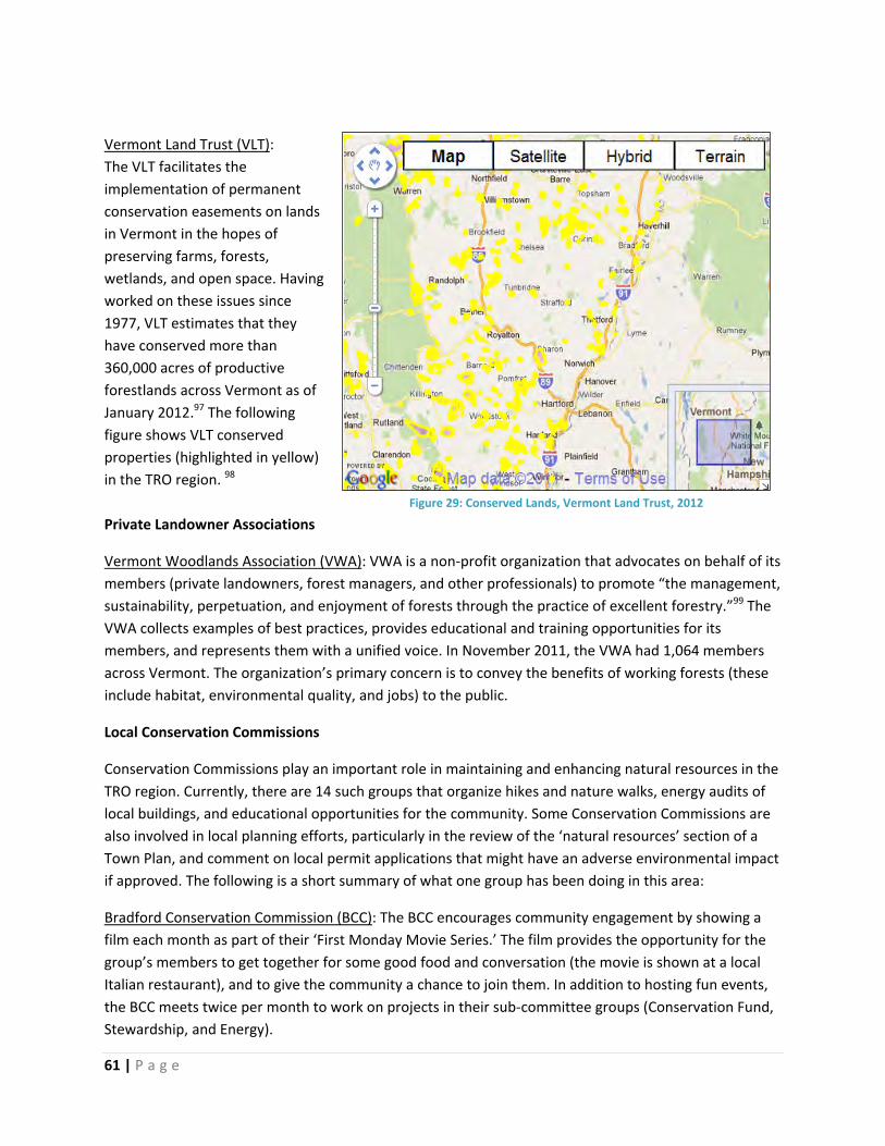
61 | P a g e
Vermont Land Trust (VLT):
The VLT facilitates the
implementation of permanent
conservation easements on lands
in Vermont in the hopes of
preserving farms, forests,
wetlands, and open space. Having
worked on these issues since
1977, VLT estimates that they
have conserved more than
360,000 acres of productive
forestlands across Vermont as of
January 2012.97 The following
figure shows VLT conserved
properties (highlighted in yellow)
in the TRO region. 98
Private Landowner Associations
Vermont Woodlands Association (VWA): VWA is a non‐profit organization that advocates on behalf of its
members (private landowners, forest managers, and other professionals) to promote “the management,
sustainability, perpetuation, and enjoyment of forests through the practice of excellent forestry.”99 The
VWA collects examples of best practices, provides educational and training opportunities for its
members, and represents them with a unified voice. In November 2011, the VWA had 1,064 members
across Vermont. The organization’s primary concern is to convey the benefits of working forests (these
include habitat, environmental quality, and jobs) to the public.
Local Conservation Commissions
Conservation Commissions play an important role in maintaining and enhancing natural resources in the
TRO region. Currently, there are 14 such groups that organize hikes and nature walks, energy audits of
local buildings, and educational opportunities for the community. Some Conservation Commissions are
also involved in local planning efforts, particularly in the review of the ‘natural resources’ section of a
Town Plan, and comment on local permit applications that might have an adverse environmental impact
if approved. The following is a short summary of what one group has been doing in this area:
Bradford Conservation Commission (BCC): The BCC encourages community engagement by showing a
film each month as part of their ‘First Monday Movie Series.’ The film provides the opportunity for the
group’s members to get together for some good food and conversation (the movie is shown at a local
Italian restaurant), and to give the community a chance to join them. In addition to hosting fun events,
the BCC meets twice per month to work on projects in their sub‐committee groups (Conservation Fund,
Stewardship, and Energy).
Figure 29: Conserved Lands, Vermont Land Trust, 2012

62 | P a g e
Other Conservation Organizations
Linking Lands Alliance (LLA): LLA is a grassroots group that works on natural resource issues which defy
traditional town boundaries. Their efforts are primarily concentrated in Hartland, Woodstock, Hartford,
Pomfret, Norwich, Sharon, Thetford, Strafford, West Fairlee, and Vershire, all of which are located
within the TRO region. LLA has embarked on several significant projects. For instance, LLA created
habitat block or connectivity maps to illustrate important wildlife corridors in the area.100 Currently, LLA
is working with groups of neighbors who are interested in enhancing forest stewardship at the sub‐
community level.
Sierra Club: The Vermont chapter of the Sierra Club (a national environmental group) has been
promoting their campaign ‘Our Forests Our Future’ across the state. Staff explain: “Our goal from the
start was (and continues to be) the building of popular support for the establishment [sic] wildlife
migration corridors connecting the northern Connecticut River with the Nulhegan Basin, the Basin to the
northern Green Mountains, and the southern Green Mountains with our western border.”101 This
mission has led them to advocate for town owned and conserved forests across the state.
Vermont Coverts: Coverts works to enhance wildlife habitat and promote healthy forest stewardship
practices among private landowners in Vermont. The group educates forest owners on how to draft and
implement a sound management plan, and Coverts also represents its constituency when interacting
with state agencies and other forest and wildlife related groups.102 Part of this work involves hosting
workshops on forest management and working with landowners through personal contacts.
Vermont Family Forests (VFF): VFF is a non‐profit family forest conservation organization that promotes
conscientious stewardship to maintain natural ecosystem health. The organization developed the
‘Forest Health Conservation Checklist’ which outlines 43 practices that ensure ecologically sustainable
management. This checklist leads to certification: a forest can be a ‘VFF Verified Forest,’ and can utilize
different branding tools, including ‘NeighborWood’ for firewood and ‘Family Forest’ for flooring and
other products.103
Vermont Natural Resources Council (VNRC): VNRC is a non‐profit, environmental advocacy organization
and the Vermont‐based wing of the National Wildlife Foundation. While the group works to address
several environmental issues (including energy, water, air, etc.), VNRC’s ‘Healthy Forests’ program is
especially strong. “Recovery of threatened and endangered species, wilderness, ecological reserves, and
sustainable forestry are key conservation components in VNRC's forest program.”104 Most notably, VNRC
coordinates the Vermont Forest Roundtable with stakeholders from across the state to discuss threats
to forests and brainstorm recommendations to ensure a sustainable future.
Vermont Tree Farm Program: Sponsored by the American Forest Foundation, the national Tree Farm
program promotes native, working forests, while receiving advice from leading foresters and
environmental specialists. In Vermont, the Tree Farm program is overseen by the Vermont Woodlands
Association’s Board of Directors. This program provides third party certification through the
international Programme for the Endorsement of Forest Certification (PEFC); the certification requires

63 | P a g e
farms to meet sustainable management standards. In November 2011, there were 424 Certified Tree
Farms in Vermont, managing approximately 167,182 acres.105
White River Natural Resource Conservation District (NRCD): The White River NRCD promotes soil and
water conservation at the local level through education, partnerships, and natural resources projects.
The organization primarily serves Orange and Windsor Counties, in addition to Granville, Hancock, and
Pittsfield—the Two Rivers‐Ottauquechee region.106
White River Partnership (WRP): The WRP is a non‐profit, grassroots organization that works in
communities across the White River watershed to improve water quality and overall health. Staff,
members, and volunteers engage in numerous activities to further WRP’s goals, including: planting
riparian buffers, monitoring water quality at various sites, educating children about ecosystem health,
and more.
Forest Products Associations
Vermont Wood Manufacturer’s Association (VWMA): The VWMA is an organization with more than 120
primary and secondary wood processors as its members. “VWMA's mission is to support the industry in
Vermont and promote its long‐term viability by expanding members [sic] presence in the marketplace,
ensuring a sustainable supply of raw materials, increasing workforce skill and acting as responsible
employers and community members.”107 Accordingly, the VWMA maintains a website on which its
members can post profiles of their company and wood products. They also helped publish “The Essential
Buyer’s Guide” to wood products manufactured in Vermont. Additionally, the VWMA offers educational
workshops and discounts on events throughout the state. Finally, the VWMA sponsors the annual
Vermont Fine Furniture & Woodworking Festival in Woodstock, VT. At the festival, woodworkers can
show off their forest products or art, and demonstrations of woodworking are offered at the Marsh‐
Billings‐Rockefeller National Historic Park.
Vermont Wood Products Marketing Council (VWPMC): The non‐profit VWPMC was created by the
Vermont Department of Economic Development in 2002 to support the local wood products industry.
The Council is composed of members of the industry, as well as trade associations. They have worked to
promote the Vermont brand (a logo used for marketing purposes), and implement other awareness
raising activities and events to support the industry. For instance, the VWPMC helped create the
Vermont Forest Heritage Trails tour program.108

64 | P a g e
AdditionalForestStewardshipStrategies
OwnershipofLand/DevelopmentRightsBy analyzing landscape‐based forest maps, the TRO Forest Stewardship Committee identified priority
areas in which increased conservation efforts could help bridge and enhance the region’s existing assets
(like the Chateauguay No Town or Taylor Valley conservation blocks). These priority areas are indicated
in black, permanent marker on the maps (below).
Figure 30: Priority Forest Areas, Two Rivers‐Ottauquechee Forest Stewardship Steering Committee, 2012
TRORC wants to ensure that private landowners manage their parcels in accordance with sound
stewardship principles.
Goal: Increase the number of private landowners in priority forest areas who are committed to forest
stewardship.
Strategy: Educate private landowners in priority forest areas about forest stewardship and the regional
context of their land.
65 | P a g e
Actions:
Map the remaining UVA parcel data (some TRO towns have not been mapped) and add a layer
indicating the consulting forester who developed the Forest Management Plan for each parcel.
Potential Partners: TRORC, Vermont Center for Geographic Information, Orange and Windsor
County foresters.
Find forest landowners’ names/addresses in priority forest areas by examining parcel records at
municipal offices. Set up a database with this information and use it for targeted outreach (for
example, mailings on forest stewardship regional priorities, welcome buckets, model UVA plans,
etc.) Potential Partners: TRORC, local forestry organizations.
Start new (or support existing) neighborhood groups of forest landowners. Potential Partners:
Linking Lands Alliance, local conservation commissions.
These goals, strategies, and actions further the following ‘Desired Future Conditions’ and ‘Goals’ of the
Vermont Forest Resources Plan:
Condition 1 (Biological Diversity), Goal 2: Protect and conserve natural communities, genetic
diversity, rare and endangered species, unique habitats, corridors and buffers.
Condition 4 (Land Ethic), Goal 1: Encourage public understanding of forest systems; Goal 2:
Increase public awareness of the critical role trees and forests play in sustaining Vermont
communities and residents; Goal 3: Increase public understanding and the application of
exemplary forest management, conservation and protection; Goal 4: Maintain and enhance
forest contribution to communities.
UseValueAppraisal(UVA)andOtherTaxIncentiveProgramsIn 2010, forty‐two percent (42%) of the land in the TRO region was enrolled in the Current Use Program,
an increase from thirty‐nine percent (39%) in 2003. In 2010, towns with the largest percentages of their
land in Current Use included Pomfret (68%), Vershire (64%), Chelsea (63%), West Fairlee (62%), and
Tunbridge and Barnard (both at 58%). Towns with the lowest percentages included Hancock (5%),
Pittsfield (10%), Hartford (18%), and Plymouth (20%).109
In spite of the fact that almost half of this region is in the Current Use program, the dual problems of
parcelization and fragmentation persist. While the Current Use program helps interested landowners
maintain their property for forest related uses (rather than subdivide and sell), many wonder whether
the program is structured in a way that best supports conservation. For instance, some believe that the
penalty for removing one’s land from the UVA program is too low, encouraging landowners who are
financially savvy to enroll in the program for tax breaks without their true dedication to long‐term
conservation.
Goal: Ensure that the UVA program enhances forest stewardship, while reducing instances of
parcelization and fragmentation.
66 | P a g e
Strategy: Highlight model Forest Management Plans for landowners considering the UVA program.
Action:
Research and develop model UVA Forest Management Plans that forest landowners could
consult prior to enrolling in the Current Use program. Such plans should be varied in their
approach to management objectives given that landowners have diverse interests, such as
wildlife habitat, maple syrup production, or timber harvesting. Potential Partners: Consulting
foresters, local forestry organizations.
These goals, strategies, and actions further the following ‘Desired Future Conditions’ and ‘Goals’ of the
Vermont Forest Resources Plan:
Condition 4 (Land Ethic), Goal 3: Increase public understanding and the application of exemplary
forest management, conservation and protection.
Condition 5 (Legal, Institutional and Economic Framework), Goal 3: Strengthen, implement and
enforce Vermont’s forestry policies, rules and laws; Goal 4: Encourage and support policies,
programs and initiatives that assist private forest landowners in maintaining the working
landscape.
StrongForestResourcesBasedBusinesses–EconomicOpportunitiesIn order to ensure that forestlands remain as such, we need to build a strong state‐wide, as well as
regional, movement that promotes a culture of thinking locally first for everything from toilet paper and
cutting boards to furniture and construction materials.
We must also ensure that there is enough and the right kind of infrastructure to support a booming local
forest‐products economy.
Goal: To have a strong local forest products movement and ensure that there is enough and the right
type of infrastructure to support production.
Strategy:
Educate and inspire consumers to shop locally for forest products.
Learn about ways to incentivize local milling of timber and advocate for support from key
institutions (State of Vermont, Vermont Wood Manufacturer’s Association (VWMA), and
others).
Actions:
Investigate the reason why some local concentration yards are inactive (for example, DCI in the
Bethel/Royalton area) and find ways to revitalize them. Potential Partners: Chambers of
Commerce, forestry organizations.

67 | P a g e
Create incentives for loggers to process lumber locally. For instance, set up additional
cooperative wholesale log yards in the area. Potential Partners: State of Vermont, local sawmills,
Vermont Wood Products Marketing Council (VWPMC).
Allow landowners to choose to have their lumber milled locally, even though this might increase
the price. Potential Partners: State of Vermont, local sawmills, Vermont Wood Manufacturer’s
Association (VWMA), Vermont Wood Products Marketing Council (VWPMC).
Determine the infrastructure gaps that encourage or even force industry to process wood
outside of Vermont. (For example, this region does not have a pulp mill for waste products.)
Potential Partners: Chambers of Commerce, forestry organizations, Vermont Wood
Manufacturer’s Association (VWMA).
Begin a ‘buy local’ campaign in the TRO region that promotes a range of wood related products
ideal for daily use or as special gifts. For example, promote products through advertising in local
newspapers, especially around holidays, and highlight the local stores that sell them. Potential
Partners: Chambers of Commerce, forestry organizations, Vermont Wood Manufacturer’s
Association (VWMA), Vermont Wood Products Marketing Council (VWPMC).
These goals, strategies, and actions further the following ‘Desired Future Conditions’ and ‘Goals’ of the
Vermont Forest Resources Plan:
Condition 3 (Forest Products and Ecosystem Services), Goal 1: Maintain and enhance the
production of forest products.
Condition 4 (Land Ethic), Goal 2: Increase public awareness of the critical role trees and forests
play in sustaining Vermont communities and residents.
Condition 5 (Legal, Institutional and Economic Framework), Goal 1: Encourage public
understanding of forest systems; Goal 2: Expand financial opportunities to support forest
stewardship; Goal 3: Increase public understanding and the application of exemplary forest
management, conservation and protection.
EducationandOutreachThe TRO Forest Stewardship Committee identified education and outreach as necessary if the region is
to remain forested. Target audiences include: private forest landowners, consulting foresters, municipal
officials, and the community (especially kids).
EducationandOutreach–PrivateForestLandowners
Goals: To have educated, informed, and inspired private forest landowners who are active stewards of
the land.
Strategy:
Provide critical information to private forest landowners to help them make informed land
management decisions.

68 | P a g e
Actions:
Map existing channels of communication with private forest landowners in this region (for
instance, via county foresters, town offices, the Linking Lands Alliance, and others). Potential
Partners: County foresters, Linking Lands Alliance, other forestry organizations.
Develop standard information and maps to include in the Linking Lands Alliance’s ‘Welcome
Buckets’ for private forest landowners. This would require developing a model mapping
template that could be applied to any parcel/address, as well as an easy‐to‐read description of
‘How To’ interpret the maps. Potential Partners: TRORC, Linking Lands Alliance, Orange &
Windsor County foresters.
Develop a check list that asks landowners to consider important issues before making decisions
concerning their forested lands. The check list should ask the landowner about his/her goals for
managing the land, his/her understanding of the regional forest stewardship priorities, and
cover potential questions that one should ask a consulting forester prior to enrolling in the
Current Use program. Potential Partners: County foresters, forestry organizations.
Compile case studies that highlight successful projects around the region. For example, topics
might include:
o Hartford’s most recent public outreach effort in relation to zoning;
o The Chateauguay No Town Conservation Project;
o The Linking Lands Alliance’s experience with organizing neighborhood groups of private
forest landowners;
o The Orange County Headwaters Conservation Project;
o The Taylor Valley Conservation Project.
Potential Partners: TRORC, the Vermont Natural Resources Council, local conservation
commissions.
Compile the following materials for private forest landowners: Various model UVA plans based
on different management goals and objectives (these should be shared with forest landowners
prior to their enrollment in the Current Use program); A description of regional forest resources,
challenges or threats to their continued existence, strategies for enhancing their stewardship,
and a review of all potential conservation and management options. Note: One possibility would
be to include this information in the ‘Welcome Buckets’ which were created by the Linking
Lands Alliance and are currently distributed by the Windsor County forester. Potential Partners:
TRORC, forestry organizations, Linking Lands Alliance, county foresters.
Start neighborhood groups of forest landowners who want to reach out to others in the
immediate area. Potential Partners: Linking Lands Alliance, forestry organizations.
Put educational materials, such as model UVA plans, online to allow for universal access. The
online repository might reside on Google Documents, a willing municipality’s website, the local
conservation commission’s website, or Facebook. Potential Partners: TRORC, conservation
commissions, forestry organizations.
These goals, strategies, and actions further the following ‘Desired Future Conditions’ and ‘Goals’ of the
Vermont Forest Resources Plan:
69 | P a g e
Condition 2 (Forest Health and Productivity), Goal 2: Maintain productive capacity of forests;
Goal 3: Retain native flora and fauna across the landscape.
Condition 4 (Land Ethic), Goal 3: Increase public understanding and the application of exemplary
forest management, conservation and protection.
Condition 5 (Legal, Institutional and Economic Framework), Goal 4: Encourage and support
policies, programs and initiatives that assist private forest landowners in maintaining the
working landscape.
EducationandOutreach–ConsultingForestersConsulting foresters help private landowners develop their Forest Management Plan when enrolling in
the UVA program. As the ‘experts,’ these foresters have a unique opportunity to help landowners
understand the connection between their parcels and the larger region. As a result, consulting foresters
are uniquely positioned to promote forest stewardship amongst private landowners.
Goal: Educate consulting foresters about regional forest stewardship priorities and local land use
regulations.
Strategy:
Provide critical information (such as GIS data) to consulting foresters who draft Forest
Management Plans under the UVA Program.
Actions:
Compile the following educational materials: the Two Rivers‐Ottauquechee Regional Forest
Stewardship Plan (this report) and the landscape based maps associated with it; the forest
related sections of TRORC’s latest Regional Plan (the forest chapter is being revised as of June
2012); a summary of stewardship priorities for the TRO region; the town plan and any zoning
regulations for towns in which a consulting forester usually works with landowners; outreach
materials generated from other sources. Potential Partners: Woodlands Certified Consulting
Foresters, Vermont Family Forests, Hogback Community College. Note: Outreach could also be
accomplished by utilizing existing forester events and venues for continuing education.
Research programs for foresters who want to become stewardship experts. Potential Partners:
Woodlands Certified Consulting Foresters, Vermont Family Forests, Hogback Community College.
These goals, strategies, and actions further the following ‘Desired Future Conditions’ and ‘Goals’ of the
Vermont Forest Resources Plan:
Condition 1 (Biological Diversity), Goal 2: Protect and conserve natural communities, genetic
diversity, rare and endangered species, unique habitats, corridors and buffers.
Condition 4 (Land Ethic), Goal 4: Maintain and enhance forest contribution to communities.
Condition 5 (Legal, Institutional and Economic Framework), Goal 3: Strengthen, implement and
enforce Vermont’s forestry policies, rules and laws.

70 | P a g e
EducationandOutreach–MunicipalOfficialsThe State of Vermont allows municipal governments to create a Town Plan and develop zoning
ordinances as long as they conform to the state’s planning goals. For those municipalities which have
embraced this type of planning, the ability to influence current and future land use is profound.
Goal: To have informed local Planning Commissions writing forest policies into land use regulations
that reflect local and regional forest stewardship data and priorities.
Strategy:
Provide critical information to municipal officials who are responsible for creating and revising
the town plan and any zoning ordinances.
Actions:
TRORC should consult with municipal officials on forest issues prior to the amendment or
renewal of a town plan or zoning ordinance. This initiative could be incorporated into the
‘Enhanced Consultation’ process in which TRORC’s staff meets with a local planning commission
to discuss the current town plan and compatibility with state planning goals. Or, TRORC could
also work with members of the local conservation commission to present this information to the
planning commission. Potential Partners: TRORC, local conservation commissions.
In preparation for consulting with town officials, a packet of model inventories should be
compiled to illustrate natural resources, wildlife and habitat, soils, and invasive species. (An
example of a model wildlife inventory is contained in Appendix B of this report). Potential
Partners: TRORC, other regional planning commissions, local conservation commissions, the
Vermont Natural Resources Council.
In preparation for consulting with town officials, the following should also be compiled: maps of
that municipality’s forest resources and how these fit into the context of the larger region; a
summary of stewardship priorities for the TRO region; the forest related sections of TRORC’s
Regional Plan; a review of regulatory and non‐regulatory strategies (including recommended
planning language). Potential Partners: TRORC, Vermont Natural Resources Council.
These goals, strategies, and actions further the following ‘Desired Future Conditions’ and ‘Goals’ of the
Vermont Forest Resources Plan:
Condition 1 (Biological Diversity), Goal 2: Protect and conserve natural communities, genetic
diversity, rare and endangered species, unique habitats, corridors and buffers.
Condition 2 (Forest Health and Productivity), Goal 1: Identify trends in forest ecosystem health
and productivity; Goal 2: Maintain productive capacity of forests; Goal 3: Retain native flora and
fauna across the landscape.
Condition 3 (Forest Products and Ecosystem Services), Goal 2: Maintain and enhance water
resources; Goal 3: Maintain and enhance recreational opportunities; Goal 4: Maintain and
enhance forest carbon; Goal 5: Maintain and enhance air resources.

71 | P a g e
Condition 4 (Land Ethic), Goal 1: Encourage public understanding of forest systems; Goal 3:
Increase public understanding and the application of exemplary forest management,
conservation and protection; Goal 4: Maintain and enhance forest contribution to communities.
Condition 5 (Legal, Institutional and Economic Framework), Goal 3: Strengthen, implement and
enforce Vermont’s forestry policies, rules and laws.
EducationandOutreach–CommunityWhen the TRO Forest Stewardship Committee discussed the challenges to maintaining forestlands in
this region, members spoke about the lack of knowledge and sometimes even respect surrounding
forest‐related jobs and products. Members felt that a cultural shift was needed, and one way that this
could begin would be through community based education.
Goal: Foster a culture in which forests and their products/services are respected.
Strategies:
Promote inspiring forest‐related
experiences for community members,
especially kids and young adults.
Promote educational lectures and
events that emphasize forest
stewardship.
Actions:
Organize a tour of a local sawmill or
larger concentration yard or a trip
that follows the Vermont Forest
Heritage Trail. Potential Partners: Linking Lands Alliance, other forestry organizations.
Work with Charles Shackleton of Shackleton Thomas to replicate his “Naked Table Project” with
students from schools across the TRO region. Note: The Naked Table Project allows participants
to take part in the entire process of building a dining table (they even harvest a local tree to use
as lumber). Ultimately, participants bring home the table they helped construct. ‘The Naked
Table Project’ is an excellent example of creating a tangible connection between residents in the
TRO region and their forests. To replicate this project, the product would likely have to be scaled
down (rather than building a table, students could produce a chopping block or wooden bowl).
Potential Partners: Shackleton Thomas, local schools, forestry organizations.
Figure 31: The Naked Table Project at Shackleton Thomas (TRORC Stock Photo)

72 | P a g e
Figure 32: Naked Table Project ‐ Certificate of Completion (TRORC Stock Photo)
These goals, strategies, and actions further the following ‘Desired Future Conditions’ and ‘Goals’ of the
Vermont Forest Resources Plan:
Condition 4 (Land Ethic), Goal 1: Encourage public understanding of forest systems; Goal 2:
Increase public awareness of the critical role trees and forests play in sustaining Vermont
communities and residents; Goal 4: Maintain and enhance forest contribution to
communities.
OtherForestry,NaturalResources&SustainabilityInitiatives
The TRO region might also benefit from replicating some of these existing projects:
Land Protection Check List: The Appalachian Trail News featured a scenic inventory check‐list in their
November – December 2002 issue. This is a model to consider for inclusion in local town plans or zoning
ordinances. For more information, see “What’s Your Scenery Score? A Land Protection Check List”
(Appendix C).
The Staying Connected Initiative: Staying Connected was pioneered by professors and students at Green
Mountain College for the region of Rutland County, VT. The initiative empowers anyone to report
wildlife sightings, which are then compiled and mapped on an interactive website. This initiative might
be replicable in the TRO area if there was an organization interested in developing a similar website and
maintaining it. A TRO initiative could be promoted by posting a link on municipal websites, TRORC’s
website, or by working with local school teachers to incorporate the project into science classes. To

73 | P a g e
learn more, visit the Staying Connected Initiative for Rutland County at:
https://sites.google.com/site/rutlandcountywildlifesightings/.

74 | P a g e
Conclusion
Although this project has come to a close, our work to promote forest stewardship in the Two Rivers‐
Ottauquechee (TRO) region is far from finished. The TRO Forest Stewardship Steering Committee
proposed many actions which now await implementation; some of the ideas will require outside
funding, many will need only a small group of motivated and dedicated people.
TRORC will spread the word as they continue to consult with local Planning Commissions on town plans
and zoning ordinances. It is our hope that emphasizing stewardship when discussing land use options
can and will have a positive impact on our forests’ future.
Zavez and Fellows, TRORC’s key staff members who worked on this project, would like to thank all of the
Forest Stewardship Steering Committee members for their hard work and dedication as stewards of this
region’s forests.

75 | P a g e
AppendixA
“StrategiesGuideforForestlandandWildlifeConservation,”VermontNaturalResourcesCouncil,2011.

Page 1
Strategies Guide For Forestland and Wildlife Conservation Prepared by Vermont Natural Resources Council
Regulatory Tool:
Description
Common Characteristics
Applicability
Conservation/ Forest Reserve District
Conservation districts typically encompass areas defined by one or more natural features, limited existing development, limited road and utility access, and large parcels. Several communities in Vermont have created forest and reserve districts that encompass high elevation land, important forest resources, and headwater protection areas.
Large Lot/Area Requirements (25+ ac.) which should be tied to resource management
Low Density Limited Uses (may exclude year-
round residential uses) Development/Resource Protection
Standards (may require Board review of all or most development activities).
Easy to administer with trained volunteer board.
To Be Determined
Overlay District
Overlay districts are superimposed over one or more underlying conventional zoning districts in order to address areas of community interest that warrant special consideration, such as protection of a particular resource, including identified forest protection priority areas or wildlife resources. An overlay district is an effective way to impose resource protection standards on land that shares a common feature. Overlay districts can be fixed or floating depending on the resource.
Development/Resource Protection Standards (may require Board review process for all or most development activities).
May alter use or dimensional standards from underlying zoning district.
Easy to administer with trained volunteer board, though may require map interpretation.
To Be Determined
Fixed-Area Zoning
Zoning standards that include both minimum area requirements for subdivided lots and maximum density standards, which may be different from lot area requirement (e.g., may require one housing unit per 25 acres yet a minimum lot size of only one acre, thereby allowing subdivision for development that does not require excessive fragmentation of large parcels). Where used effectively, there is often a maximum lot size to prevent fragmentation.
Typically used in Conservation districts to conserve productive land (e.g., farm, forest land) or natural resources.
May be confusing. Requires administrative capacity to
ensure appropriate tracking.
To Be Determined

Page 2
Strategies Guide For Forestland and Wildlife Conservation
Prepared by Vermont Natural Resources Council
Regulatory Tool:
Description
Common Characteristics
Applicability
Clustering (Planned Unit Developments)
Planned Unit Development (PUD) provisions authorize a local review board to “waive” or “modify” specific zoning standards (e.g., lot size, setbacks, etc.) for the purpose of achieving a better development design than would be possible under a strict application of the zoning standards. Common standards include smaller lots than otherwise allowed in district to facilitate clustering and the preservation of open space.
Typically authorize density bonuses. Usually encourage clustering and
protection of open space (often min. open space standard).
Typically discretionary, but statute allows municipality to mandate PUD review for certain projects or in specified districts.
Density based on underlying zoning (plus density bonus) – may allow uses not otherwise allowed in district.
Requires some administrative capacity
To Be Determined
Transfer of Development Rights
Authorizes communities to allow for development rights to be removed from a parcel in a district with resource values (sending parcel) to a parcel in an area that has been targeted for development (receiving parcel), thereby increasing the density. Though often cited as a useful conservation tool, its application in Vermont has been very limited for a variety of reasons, including the lack of market demand for density that exceeds the allowable zoning densities, the lack of receiving areas that have the capacity for significant increases of development density, and the administrative requirements for such a program. Some communities have created a modified TDR program by allowing non-contiguous PUDs, thereby allowing the transfer of development rights to one parcel in a rural (low density) district provided that another, non-contiguous parcel is maintained as open space.
A successful TDR program typically include (1) a hot real estate market where the demand for density exceeds current zoning; (2) an adequate receiving area (with infrastructure to accommodate development and zoning densities significantly below market demand); and (3) defined sending areas. Most Vermont towns have ample sending areas, but likely lack a demand or capacity for density bonuses in designated “growth areas” to make a significant impact on conserving forest land (though a system could be developed fairly simply to provide TDRs as an option).
Does require some administrative capacity.
To Be Determined

Page 3
Strategies Guide For Forestland and Wildlife Conservation
Prepared by Vermont Natural Resources Council
Regulatory Tool
Description
Common Characteristics
Applicability
Subdivision Regulations
Subdivision regulations are typically used to guide settlement patterns and the extension of utilities and infrastructure, and increasingly to establish standards to protect natural and cultural resources. Many communities not only regulate the configuration of lots, but the extent of site disturbance and site improvements (including the location of structures) as well, and some communities have used subdivision regulations to regulate density in conjunction with zoning bylaws. Some communities require what is often referred to as “conservation subdivision design,” in which the subdivider must document the steps taken to identify and protect specified primary and secondary resources on the parcel.
May include standards to protect identified resources, including wildlife habitat, steep slopes, etc., through lot layout and open space protection.
Often used to guide development of subdivided lots through building envelopes and driveway and utility standards.
May address issues associated with private road construction and the upgrade of class 4 roads.
Can include specific standards for different zoning districts, including provisions to configure lots with consideration to current forest management/stand type, and to ensure ongoing forest management after subdivision.
To Be Determined
Site Development Standards
Many of the tools described above are really different types of administrative procedures used to apply resource protection and site development standards to landowners within a town or particular area (e.g., districts) within a community. A zoning bylaw may also impose general development standards that might apply to specific activities (e.g., driveway construction) or development on particular land characteristics (e.g., steep slopes) regardless of their location in the Town.
May be resistance to requiring a permit and/or review process that is not currently subject to such a review.
Regulating certain site features (e.g. steep slopes may be difficult unless the Town requires detailed site information as part of zoning permit application.
To Be Determined

Page 4
Strategies Guide For Forestland and Wildlife Conservation
Prepared by Vermont Natural Resources Council
Regulatory Tool
Description
Common Characteristics
Applicability
Road and Trail Policies
Class 4 roads (public roads not maintained for year-round travel) typically provide access to areas of unfragmented forest. The adoption of policies to guide how such roads can be upgraded to serve development (i.e. new housing/subdivisions) can be an important means of managing fragmentation. Some communities have downgraded class 4 roads to “public trail” status, thereby removing the threat of upgrade. Others have treated class 4 roads differently than other roads in zoning (e.g., by requiring frontage on class 3 or higher for development purposes). Many communities have trail policies that articulate a vision for recreational trails and the level of development that should be allowed along town trails.
Class 4 road policies should be based on an inventory of roads and consideration to how existing road policies relate to land use policies.
Downgrading class 4 roads to trail status can be an effective way of avoiding future upgrade and related development, but many communities are reluctant to forfeit future transportation options.
Zoning standards can differentiate between class 4 roads and those maintained for year-round travel.
It is critical that the Selectboard, who have jurisdiction over local roads, are involved early in any discussion over road policy and follow correct procedures for reclassifying the status of roads and trails.
To Be Determined
Ensure that Forest Products Industries are allowed in Community
Allowing sawmills and related processing facilities in appropriate zoning districts can support the local forest products industry. In addition, ensuring that the definition of forestry includes the on-sight processing of forest products (e.g., with the use of portable sawmills) has become increasingly important to some loggers.
Sawmills, or “Forest Products Processing,” is often allowed in Industrial Districts, and appropriate rural-residential districts (subject to performance standards to mitigate off-site impacts, such as excessive noise).
Forestry definitions are suitably broad to allow processing of timber harvesting on the site.
To Be Determined

Page 5
Strategies Guide For Forestland and Wildlife Conservation Prepared by Vermont Natural Resources Council
Regulatory Tool
Description
Common Characteristics
Applicability
Forest Practices
A municipality can require that logging operations comply with Acceptable Management Practices for Maintaining Water Quality. In addition, a municipality can require compliance with the Minimum Standards for Forest Management and Regeneration of the Use Value Appraisal Program for all lands that are enrolled in the Program. Beyond these standards, a municipality may enact a bylaw that imposes forest management practices resulting in a change in a forest management plan for land enrolled in the Use Value Appraisal Program only to the extent that those changes are silviculturally sound, as determined by the Commissioner of Forests, Parks, and Recreation, and protect specific natural, conservation, aesthetic, or wildlife features in properly designated zoning districts. Furthermore, a municipality can regulate clearcutting or land clearing if the purpose of the clearing is not related to silviculture, such as creating a view or facilitating land development. However, a municipality may not regulate clearcutting if the purpose of the management is for silvicultural purposes, i.e. to harvest and regenerate trees.
The regulation of forest practices mostly falls under the jurisdiction of the state.
Forestry standards or guidelines would typically be added to the zoning bylaw.
A municipality could feasibly impose forest management practices for shoreline protection areas or certain wildlife features, such as deer-wintering yards, in designated zoning districts. The Commissioner would need to review such a policy to ensure that any practices imposed on land enrolled in the UVA Program are silviculturally sound.
A municipality may regulate road development for logging through the creation of road design standards.
A community that would like to regulate clearcutting that is related to land clearing for development could require that a conditional use permit be granted for such clearing.
To Be Determined

Page 6
Strategies Guide For Forestland and Wildlife Conservation Prepared by Vermont Natural Resources Council
Regulatory Tool
Description
Common Characteristics
Applicability
Clear Definitions for “Important” or “Significant” Resources
Zoning bylaws and subdivision regulations must articulate with specificity “important” or “significant” natural resource features that are the subject of regulation in a municipality. For example, if a community wishes to protect “significant” or “important” scenic resources, wildlife habitat, or “special” natural resource features, these features should be identified in a map, or described with specific standards and definitions to guide enforcement. The Vermont Supreme Court, in the recent case In re Appeal of JAM Golf, LLC, struck down a South Burlington zoning ordinance designed to “protect important natural resources including streams, wetlands, scenic views, wildlife habitats and special features such as mature maple groves or unique geologic features.” The Supreme Court found the regulation did not provide sufficient standards to be enforceable. Municipalities should be sure to write specific standards that define what important or significant features are and how they should be protected.
Sound regulations will typically include definitions for important or significant features, such as wildlife habitat.
Another tool includes having a significant natural resources map that is referenced in the zoning or subdivision regulations and the town plan. This map, or series or maps, depending on the features of interest, should be updated over time.
Some municipalities use standard language such as “no undue adverse impact on important or significant resources”. This language does not appear to be impacted by the JAM Golf decision.
The desired level of protection should be spelled out in the regulations, i.e. outright preservation, capable of being mitigated, etc.
To Be Determined
Impact Fees
Vermont communities are authorized to levy impact fees against development projects. An impact fee is a means of charging for the impact that new development has on the demand for public facilities (i.e. the demand for new or expanded facilities that will result from that development). Impact fees are commonly used to fund recreation facilities, school expansion, roads, and have been used to fund open space conservation. An impact fee may only charge a project for the proportional demand attributable to that development, and must exempt property tax revenues that will be charged to that project to fund the facility (e.g., to retire a bond).
A “level of service” for the facility (e.g., 25 acres of open space per resident) must be established.
Costs must be projected for the life of facilities (e.g. 20 years).
Costs attributable to both new and existing development within the municipality must be identified.
Fees collected must be used within the capital budgeting period (6 years), or returned to the payer.

Page 7
Strategies Guide For Forestland and Wildlife Conservation Prepared by Vermont Natural Resources Council
Non-Regulatory
Tool
Description
Common Characteristics
Applicability
Education About the Use Value Appraisal (UVA) Program (Current Use Program)
The Use Value Appraisal program provides an incentive for private landowners to keep forestland productive and undeveloped. The program assesses forestland at its use value rather than fair market value, which lowers the property tax assessment for landowners who enroll. There are many misperceptions about the tax implications of enrolling land in the Use Value Appraisal program. For example, the State of Vermont reimburses communities for all of the tax revenue that is lost due to enrollment of land under the program.
The Town Plan could explain the benefits and characteristics of the program and clarify any misperceptions about the tax implications of the program.
A landowner outreach campaign could be coordinated to encourage more landowners to enroll in the program.
To Be Determined
Education about Conservation Easements and Land Trusts
Conservation easements are important tools for landowners who want to conserve their land in perpetuity. They are voluntary agreements that allow landowners to restrict the type or amount of development on their property while retaining private ownership of the land. Many landowners receive a federal income tax deduction for the gift of a conservation easement. There may be other tax benefits as well, such as reduced property taxes, in some circumstances. Listers and appraisers should be made aware of the appraisal guidelines for conserved land.
A land trust will hold the development rights while the landowner maintains ownership of the land.
The land may be transferred or sold, but the easement restricting development typically runs with the land.
Use of the land such for sustainable forestry or recreation is typically allowed, if not encouraged, through easements.
To Be Determined

Page 8
Strategies Guide For Forestland and Wildlife Conservation
Prepared by Vermont Natural Resources Council
Non-Regulatory
Tool
Description
Common Characteristics
Applicability
Landowner Cooperatives to Manage and/or Conserve Land
Landowner cooperatives can be created so that landowners share in the costs of managing land and to foster conservation, stewardship, and market forest products. Landowners who coordinate activities through a cooperative or association can potentially apply for federal or state assistance, share in road and timber management improvements, develop comprehensive wildlife habitat conservation and forest management plans, and seek conservation easements or third party certification for sustainable forest management if desired.
Existing forest landowner cooperatives such as Vermont Family Forests and the Orange County Headwaters Project serve as good models in the state.
A similar option is to create a community based Timberland Investment Management Organization to buy and manage forestland collectively.
To Be Determined
Education About Federal and State Assistance Programs
There are state and federal programs that exist to help landowners with conservation or management projects. Information about these programs could be presented at a workshop or through the distribution of landowner tool kit or welcome kit for new landowners. There are too many state and federal programs to list here, but several include:
Forest Legacy
Landowner Incentive Program
Wildlife Habitat Incentive Program
State and federal programs sometimes require matching funds.
In order to receive funding, projects must match certain criteria depending on the goals of the program.
Each program typically has a state coordinator that can help landowners apply to the program.
To Be Determined
Perform a Build-Out Model for the MRW
Conducting a build-out analysis of potential development in the watershed could assist planning efforts and reinforce the need for regulatory and non-regulatory tools to avoid forest fragmentation. Visual models are good tools for weighing management decisions that could impact forestland.
A build-out assessment of rural/ residential zoning districts is a fairly simple process using widely available GIS programs.
To Be Determined
Promote Local Forest Products
The forest products industry is an important part of Vermont’s economy. Sawmills, wood or lumber processing, and local manufacturing and energy systems using forest resources from within the watershed are important ways to keep forestland productive for forestry in the community. Residents should be educated about the importance of the local forest products industry.
The buy local movement could be translated to forest products to encourage residents to use local materials.
Local architects and builders could be encouraged to use local materials.
To Be Determined

Page 9
Strategies Guide For Forestland and Wildlife Conservation
Prepared by Vermont Natural Resources Council
Non-Regulatory
Tool
Description
Common Characteristics
Applicability
Education About Third Party Certification of Forestland
Third party certification allows landowners to receive an independent audit that certifies that land is being managed in a sustainable fashion. There is potential for landowners and forest products that are certified to receive a premium among buyers for certified materials. There are several certification programs including Forest Stewardship Council, Vermont Family Forests, Sustainable Forestry Initiative, and Tree Farm.
Third party certification does cost landowners money to administer.
Markets are still emerging for certified products and the premium for engaging in the certification process is still being realized, although there is potential as carbon offset markets are developed to deal with climate change.
To Be Determined
Map and Inventory Wildlife Corridors and Natural Heritage Features
Having up-to-date maps and inventories of natural heritage features can greatly complement conservation work in your community. The Department of Fish and Wildlife can assist in the mapping of wildlife or habitat corridors. Private consulting firms can also assist by performing field inventories of important ecological resources on public land or private land (with the consent of willing landowners). An excellent resource is Conserving Vermont’s Natural Heritage: A Guide to Community-Based Planning for the Conservation of Vermont’s Fish, Wildlife, and Biological Diversity published by the Vermont Department of Fish and Wildlife.
Habitat corridor maps can help promote land conservation where appropriate and guide local management decisions such as new road construction or the placement of guardrails and other road maintenance issues.
Ecological inventories can provide useful information on rare and threatened species, natural communities, critical wildlife habitat, wetlands, and other important resources. Such information can assist regulatory review, but also be valuable for prioritizing non-regulatory conservation and education efforts.
To Be Determined

Page 10
Strategies Guide For Forestland and Wildlife Conservation
Prepared by Vermont Natural Resources Council
Non-Regulatory
Tool
Description
Common Characteristics
Applicability
Create a Town Forest
Recognizing the important characteristics of publicly owned forestland, it is surprising to know that slightly less than a half of all Vermont communities still do not own town forests or parcels of municipal forestland. Interested citizens and town officials may explore opportunities for creating town forests with the assistance of county foresters, interested landowners, and conservation organizations. An excellent resource for town forest acquisition and stewardship is The Vermont Town Forest Stewardship Guide: A Community Users’ Manual for Town Forests published by the Northern Forest Alliance.
The benefits of town forests include, but are not limited to, access for recreation, wildlife habitat, forest products, watershed protection, and opportunities for public education.
Organizations engaged in the acquisition and creation of town forests include the Trust for Public Land, Vermont Land Trust, Vermont Housing and Conservation Board, and the county foresters with the Department of Forests, Parks, and Recreation.
To Be Determined
Forest Management or Conservation Demonstration Projects
Excellent examples of forest management and stewardship may be showcased as an education opportunity for residents and landowners. In addition, a property that has been conserved through the Vermont Land Trust or a similar conservation organization could serve as model for how easements are utilized.
Organizations such as Audubon Vermont, Vermont Woodlands Association and Vermont Coverts: Woodlands for Wildlife offer educational opportunities for forestland stewardship. A project could be coordinated with these entities or others.
To Be Determined
For More Information Please Contact:
Jamey Fidel, Forest and Biodiversity Program Director, Vermont Natural Resources Council – 223-2328 ext. 117 – [email protected] Brian Shupe, Sustainable Communities Director, Vermont Natural Resources Council – 223-2328 ext. 114 – [email protected]

86 | P a g e
AppendixBWestFairlee’sModelWildlifeInventory.“II.ExistingWildlife,”WestFairleeTownPlan,2005,pg.45.

45
Ompompanoosuc River (East Branch): Rainbow Trout (600 stocked by the state in 2005) Atlantic Salmon (34,800 fry stocked in 2004; none programmed for 2005) Waterfowl: Numerous duck species: Wood Duck Mallard Black Merganser Canadian Goose
Owls: Barn Great Horned Screech Barred Numerous other species of birds: Song Birds Woodpeckers Turkey Vulture Raven Mammals: White-Tailed Deer Black Bear Bobcat Moose Coyote Gray Fox Red Fox Mink Snowshoe Rabbit (Varying Hare) Otter Muskrat Raccoon Porcupine Skunk Fisher Ground Hog Weasel Red Squirrel Flying Squirrel Beaver Gray Squirrel Chipmunk and other smaller rodents Amphibians: Numerous turtle, frog and salaman-der species Reptiles: Both water and woodland snakes and tree frogs
Lake Fairlee: Warm-water and cold-water fish: Rainbow and Brown Trout (1500 of each stocked by the state in 2005) Largemouth and Smallmouth Bass Yellow Perch Chain Pickerel Pumpkinseed Rock Bass Sucker Horned Pout (Brown Bullhead) Sunfish Bluegill Eel Minnows
Loon Great Blue Heron Green Heron American Bittern Birds of Prey: Red-tailed Hawk Osprey Marsh Hawk Peregrine Falcon Sparrow Hawk Game Birds: Partridge (Ruffed Grouse) Wild Turkey Morning Dove Snipe Woodcock
II. Existing Wildlife
Existing Wildlife. Humming birds dart and dance like Red Sox pitcher Tim Wakefield’s knuckleball. They are classified here as song birds. Photographs: Hummingbirds flying near Roger Bailey’s back porch.
6. Appendices
88 | P a g e
AppendixC“What’sYourSceneryScore?ALandProtectionCheckList,”AppalachianTrailNews,Nov.–Dec.2002Issue,pg.11.

APPALACHIAN TRAILWAY NEWS 11
What’s your scenery score? A land-protection checklist
You might think that, if you’re deciding whether part of a land-scape is worth protecting, you already know how to describe it: “beautiful,” “spectacular,” “stunning,” “ugly,” “blue,” “big,” et cetera. You’d be wrong.
Before ATC’s land trust starts beating the bushes for some-body to buy a piece of land that’s near the Trail, and convincing them to put conservation restrictions on it so that it won’t be developed further, someone has to decide how directly it affects a hiker’s A.T. experience. The following is condensed from a more detailed checklist that the Conference’s land trust uses in the fi eld.
The criteria in the checklist at right don’t suit all situations equally well, and information about some of the items (such as natural resources) may not always be available. Still, by totaling up the points, Conference representatives can get an idea of whether a given tract of land appears to be something that could directly or indirectly affect the A.T. experience and consider whether the land should be a candidate for protection efforts.
A few notes about terminology:The terms “foreground,” “middle-ground,” and “background”
come from the USDA Forest Service’s Scenery Management System, which is a much more complicated process that the government uses in assigning scenic values to different parts of the landscape. As a rule of thumb, foreground is the area between an observer on the Trail and the point at which indi-vidual leaves or small branches can no longer be discerned, up to 1/2 mile from the viewer. Middle-ground is from the point where the foreground ends to a point where texture in vegetation masses is no longer discernable (up to 4 miles from the fore-ground). Background extends from there (4 miles from the viewer) to the horizon.
Another important consideration is noise: The trust uses a standard derived from a Penn State study that sets the maximum acceptable level of noise for a hiker in the natural environment at 10 decibels below that of the normal acceptable level for recreation land use (65 decibels), measured from the source to the listener. By way of comparison, to an observer in a busy street, the noise level is about 80 decibels, a jackhammer is
about 120 decibels, and a Boeing 747 taking off is about 140 decibels. Subjected to noise of 45 decibels, the average person cannot sleep; at 120 decibels, the ear registers pain. Hearing damage typically begins at 85 decibels.
Wintergreen and Humpback Rocks, Virgina: protected in 1983

90 | P a g e
AppendixD
ForestryResources(alistoforganizationsandwebsites).CompiledbyTRORCStaff,June2012.

Forest Stewardship Resources The 2010 Vermont Forest Resources Plan is a comprehensive assessment of the state’s forest resources, as well as strategies for future management. It was produced by the Vermont Department of Forests, Parks and Recreation.
http://www.vtfpr.org/htm/for_resourcesplan.cfm
Conserving Vermont’s Natural Heritage was published in 2004 by the Vermont Fish and Wildlife Department and Agency of Natural Resources as a “Guide to Community-Based Planning for the Conservation of Vermont’s Fish, Wildlife, and Biological Diversity.”
http://www.vtfishandwildlife.com/library/maps/Community_Wildlife_Program/complete.pdf
Danville Town Forest Stewardship Plan is a sample stewardship plan that was published in 2008.
http://www.prep.unh.edu/resources/pdf/danville_town_forest-tod-08.pdf
Fragmentation of Prime Vermont Forestland was published in the Vermont Environmental Report, Spring 2006.
http://www.vnrc.org/article/articleview/12019/1/621/
Informing Land Use Planning and Forestland Conservation Through Subdivision and Parcelization Trend Information contains research and analysis of Vermont data on parcelization and fragmentation of forestland. On the website, you can download your town’s individual data.
Project Website: http://svr3.acornhost.com/~vnrcorg/report/
Report (2010):
http://svr3.acornhost.com/~vnrcorg/report/Full%20Subdivision%20Report%20with%20Appendi
ces.pdf
The Landscape Stewardship Project was created by the USDA Forest Service as a resource for individuals who are interested in forest stewardship programs.
Northeastern Area (federal) website: http://www.na.fs.fed.us/landscapestewardship/
Vermont website: http://www.vtfpr.org/resource/for_forres_steward.cfm
The Linking Lands Alliance Habitat Block and Linkage Map shows existing and potential for contiguous wildlife habitat blocks in a ten town region encompassing West Fairlee, Vershire, Strafford, Thetford, Sharon, Norwich, Pomfret, Hartford, Woodstock, and Hartland.
http://www.vcgi.org/commres/vsdp/archive/LLA_intro_hilke.pdf
The Staying Connected Initiative empowers anyone to report wildlife sightings, which are then compiled and mapped on an interactive website for Rutland County, Vermont.

http://www.stayingconnectedinitiative.org/
Planning for Forest Stewardship: a Desk Guide gives detailed instructions on how to develop and write a management plan that reflects forest stewardship values.
http://www.fs.fed.us/spf/coop/library/Forest%20Stewardship%20deskguide.pdf
Vermont Coverts – Woodlands for Wildlife is a group that seeks to educate owners of private woodlots in the principles of sound forest stewardship and wildlife habitat conservation.
http://www.vtcoverts.org/
The Vermont Forest Heritage Trail “is a highway-based, regionally-themed itinerary and driving tour that unifies and connects diverse forest-product-related experiences for visitors and residents alike.” There are several stops in the TRO region.
http://www.vermontforestheritage.org/
The Vermont Forest Roundtable is convened by the Vermont Natural Resources Council and comprised of citizens who are interested in the future of Vermont’s forests. Recently, the group released a publication addressing issues of parcelization and fragmentation.
Website: http://svr3.acornhost.com/~vnrcorg/frt/
Final Report: http://svr3.acornhost.com/~vnrcorg/frt/report.htm
The Vermont Wood Products Marketing Council is a non-profit that was created by the Vermont Department of Economic Development in 2002 to support the local wood products industry. The Council is composed of members from the industry and trade associations. The Council has promoted a Vermont wood products brand (with a logo for advertising), and also developed the Vermont Forest Heritage Trail (see entry, above).
Website: http://vermontwood.org/
Vermont Brand Participants: http://vermontwood.org/brandusers.html
Woodland Owners Guide to Internet Resources provides a list of useful information to the non-industrial private forest landowner, including publications, fact sheets, and links to other helpful sites.
http://na.fs.fed.us/pubs/misc/flg/

93 | P a g e
Citations 1 Vermont Department of Forests, Parks and Recreation, “Vermont Forest Resource Fact Sheet.” Website:
http://www.na.fs.fed.us/ra/factsheets/vt_brief.pdf (accessed July 23, 2012). 2 Vermont Department of Forests, Parks and Recreation, “Vermont Forest Resource Fact Sheet.” Website: http://www.na.fs.fed.us/ra/factsheets/vt_brief.pdf (accessed July 23, 2012). 3 Vermont Family Forests & Vermont Natural Resources Council, “Informing Land Use Planning and Forestland Conservation Through Subdivision and Parcelization Trend Information,” 2010. Pg. 9. Website: http://svr3.acornhost.com/~vnrcorg/report/Full%20Subdivision%20Report%20with%20Appendices.pdf (accessed June 13, 2012). 4 Vermont Family Forests & Vermont Natural Resources Council, “Informing Land Use Planning and Forestland Conservation Through Subdivision and Parcelization Trend Information,” 2010. This citation concerns the “Town Data” section of their research project, which can be found on the website only (it is not listed in the report). Website: http://svr3.acornhost.com/~vnrcorg/cgi‐bin/town2.cgi?ALLTOWNS (accessed June 11, 2012). 5 U.S. Census Bureau, U.S. Census, 2000 and 2010. 6 North East State Foresters Association, “The Economic Importance and Wood Flows from Vermont’s Forests, 2007,” 2007. Pg. 3. Website: http://www.vtfpr.org/includes/documents/ecimportfor.pdf (accessed June 13, 2012). 7 North East State Foresters Association, “The Economic Importance and Wood Flows from Vermont’s Forests, 2007,” 2007. Pg. 3, 7. Website: http://www.vtfpr.org/includes/documents/ecimportfor.pdf (accessed June 13, 2012). 8 U.S. Census Bureau, 2005‐2009 American Community Survey 5‐Year Estimates, 2009 (publication date). 9 U.S. Census Bureau, 2005‐2009 American Community Survey 5‐Year Estimates, 2009 (publication date). 10 North East State Foresters Association, “The Economic Importance and Wood Flows from Vermont’s Forests, 2007,” 2007. Pg. 3 (“Primary”), 5 (“Secondary”). Website: http://www.vtfpr.org/includes/documents/ecimportfor.pdf (accessed June 13, 2012). 11 Brubeck, Sarah, “Sap Flow Ends Early: Sugaring Ending When It Typically Would Be Taking Off,” The Valley News, March 19,
2012. Website: http://www.vnews.com/03192012/8434261.htm (accessed June 12, 2012). 12 New England Regional Assessment Group, “Preparing for a Changing Climate: The Potential Consequences of Climate Variability and Change. New England Regional Overview,” U.S. Global Change Research Program, University of New Hampshire, 2001. Pg. 33. Website: http://www.necci.sr.unh.edu/necci‐report/NERAch5.pdf (accessed June 11, 2012). 13 North East State Foresters Association, “The Economic Importance and Wood Flows from Vermont’s Forests, 2007,” 2007. Pg. 6. Website: http://www.vtfpr.org/includes/documents/ecimportfor.pdf (accessed June 13, 2012). 14 Vermont Family Forests & Vermont Natural Resources Council, “Informing Land Use Planning and Forestland Conservation Through Subdivision and Parcelization Trend Information,” 2010. This citation concerns the “Town Data” section of their research project, which can be found on the website only (it is not listed in the report). Website: http://svr3.acornhost.com/~vnrcorg/cgi‐bin/town2.cgi?ALLTOWNS (accessed June 11, 2012). 15 Vermont Family Forests & Vermont Natural Resources Council, “Informing Land Use Planning and Forestland Conservation Through Subdivision and Parcelization Trend Information,” 2010. This citation concerns the “State Trends” section of their research project, which can be found on the website only (it is not listed in the report). Website: http://svr3.acornhost.com/~vnrcorg/report/trends.html (accessed June 13, 2012). 16 Vermont Forest, Parks & Recreation, “Vermont Invasive Forest Pest Update: Emerald Ash Borer,” 2012. Website: http://www.vtfpr.org/protection/eabupdate.cfm (accessed June 11, 2012). 17 Vermont Department of Forests, Parks & Recreation, "Vermont Invasive Forest Pest Update: Hemlock Woolly Adelgid." Pg. 1. Website: http://www.vtfpr.org/protection/documents/hwaupdate2.pdf (accessed June 13, 2012). 18 Vermont Department of Forests, Parks & Recreation, "Vermont Invasive Forest Pest Update: Hemlock Woolly Adelgid." Pg. 1. Website: http://www.vtfpr.org/protection/documents/hwaupdate2.pdf (accessed June 13, 2012). 19 Burns, Barbara, “Hemlock woolly adelgid found in Bennington County by volunteer,” VT Digger, July 18, 2012. Website: http://vtdigger.org/2012/07/18/hemlock‐woolly‐adelgid‐found‐in‐bennington‐county‐by‐volunteer/ (accessed July 23, 2012). 20 Keese, Susan, "Vermont Working To Detect The Emerald Ash Borer," Vermont Public Radio, June 19, 2011. Website: http://www.vpr.net/news_detail/90900/vermont‐working‐to‐detect‐emerald‐ash‐borer/ (accessed June 12, 2012). 21 U.S. Department of Agriculture, Forest Service, “About the Green Mountain National Forest.” Website: http://www.fs.fed.us/r9/forests/greenmountain/htm/greenmountain/g_about.htm (accessed June 11, 2012). 22 Vermont Fish & Wildlife Department, “Arthur Davis Wildlife Management Area.” Website: http://www.vtfishandwildlife.com/library/maps/Wildlife%20Management%20Areas/Springfield%20District/Arthur%20Davis%20WMA.pdf (accessed June 11, 2012).

94 | P a g e
23 http://www.vtstateparks.com/htm/coolidge.htm 24 Vermont Fish & Wildlife Department, “Les Newell Wildlife Management Area.” Website: http://www.vtfishandwildlife.com/library/maps/Wildlife%20Management%20Areas/Springfield%20District/Les%20Newell%20WMA.pdf (accessed June 11, 2012). 25 Vermont Fish & Wildlife Department, “Pine Mountain Wildlife Management Area.” Website: http://www.vtfishandwildlife.com/library/maps/Wildlife%20Management%20Areas/Barre%20District/Pine%20Mountain%20WMA.pdf (accessed June 11, 2012). 26 Northern Forest Alliance, "The Vermont Town Forest Stewardship Guide: A Community Users' Manual for Town Forests." Pg. 5. Website: http://www.communitiescommittee.org/pdfs/TownForestStewardshipGuide.pdf (accessed June 12, 2012). 27 West Fairlee, Vermont, “Brushwood Community Forest Information.” Website: http://www.westfairleevt.com/index.asp?Type=B_BASIC&SEC={47DED492‐D3AB‐4699‐BAEE‐4B0F1315A662} (accessed June 12, 2012). 28 West Fairlee, Vermont, “Brushwood Community Forest Information.” Website: http://www.westfairleevt.com/index.asp?Type=B_BASIC&SEC={47DED492‐D3AB‐4699‐BAEE‐4B0F1315A662} (accessed June 12, 2012). 29 Vermont Land Trust, Newsletter, Spring 2011. Pg. 11. Website: http://www.vlt.org/images/0_PDFs/Newsletter%20PDFs/2011_2_Newsletter.pdf (accessed June 11, 2012). 30 Tunbridge, Vermont, “Out and About in Taylor Valley,” 2010. Website: http://www.tunbridgevt.com/out‐and‐about‐in‐taylor‐valley/ (accessed June 11, 2012). 31 Two Rivers‐Ottauquechee Regional Commission, “Conservation: Chateauguay No Town (CNT) Conservation Project.” Website: http://www.trorc.org/conscnt.html (accessed June 11, 2012). 32 Vermont Land Trust, “Orange County Headwaters: Sustaining Forestry…Engaging a Community,” 2006‐2007. Website: http://www.vlt.org/news‐publications/publications‐archive/archived‐articles/orange‐county‐headwaters (accessed June 12, 2012). 33 Vermont Department of Forests, Parks & Recreation, 2010. 34 TRORC 2007 Regional Plan, “V. Agriculture and Forestry,” 2007. Pg. 98. 35 TRORC 2007 Regional Plan. Pg. 30. 36 TRORC 2007 Regional Plan. Pg. 106. 37 TRORC 2007 Regional Plan. Pg. 105. 38 TRORC 2007 Regional Plan. Pg. 107‐9. 39 TRORC 2007 Regional Plan. Pg. 109‐110. 40 Bradford Town Plan, 2009. Pg. 98‐99. 41 Bradford Town Plan, 2009. Pg. 99. 42 Bradford Zoning Bylaws, 2005. Pg. 11. 43 Bradford Zoning Bylaws, 2005. Pg. 12. 44 Bradford Zoning Bylaws, 2005. Pg. 13. 45 Hartford Chapter 4 Zoning Regulations, 2008 (amended). Pg. 33. 46 Hartford Chapter 4 Zoning Regulations, 2008 (amended). Pg. 31. 47 Hartford Chapter 4 Zoning Regulations, 2008 (amended). Pg. 32. 48 West Fairlee Town Plan, 2005. Pg. 30. 49 West Fairlee Town Plan, 2005. Pg. 30. 50 West Fairlee Town Plan, 2005. Pg. 30 ‐31. 51 West Fairlee Town Plan, 2005. Pg. 30 ‐31. 52 West Fairlee Town Plan, 2005. Pg. 31. 53 West Fairlee Town Plan, 2005. Pg. 31. 54 Hartford Master Plan, 2007. Pg. 252. 55 Hartford Subdivision Regulations, 1987. Pg. 1. 56 Hartford Subdivision Regulations, 1987. Pg. 11. 57 Hartford Subdivision Regulations, 1987. Pg. 11. 58 Hartford Subdivision Regulations, 1987. Pg. 15. 59 Hartford Subdivision Regulations, 1987. Pg. 16. 60 West Fairlee Town Plan, 2005. Pg. 24. 61 Bradford Zoning Bylaws, 2005. Pg. 29. 62 Bradford Zoning Bylaws, 2005. Pg. 30. 63 Bradford Zoning Bylaws, 2005. Pg. 39. 64 Hartford Chapter 4 Zoning Regulations, 2008 (amended). Pg. 35. 65 Hartford Chapter 4 Zoning Regulations, 2008 (amended). Pg. 34‐35.

95 | P a g e
66 Hartford Chapter 4 Zoning Regulations, 2008 (amended). Pg. 36. 67 Bradford Town Plan, 2009. Pg. 64. 68 Bradford Town Plan, 2009. Pg. 87. 69 Bradford Town Plan, 2009. Pg. 64. 70 Bradford Town Plan, 2009. Pg. 64. 71 Bradford Town Plan, 2009. Pg. 64. 72 Bradford Town Plan, 2009. Pg. 63. 73 Bradford Town Plan, 2009. Pg. 62‐63. 74 West Fairlee Town Plan, 2005. Pg. 24. 75 West Fairlee Town Plan, 2005. Pg. 24‐ 25. 76 West Fairlee Town Plan, 2005. Pg. 27. 77 West Fairlee Town Plan, 2005. Pg. 27. 78 West Fairlee Town Plan, 2005. Pg. 27. 79 West Fairlee Town Plan, 2005. Pg. 27‐ 28. 80 West Fairlee Town Plan, 2005. Pg. 32. 81 West Fairlee Town Plan, 2005. Pg. 19. 82 West Fairlee Town Plan, 2005. Pg. 19. 83 Hartford Master Plan, 2007. Pg. 297. 84 Bradford Town Plan, 2009. Pg. 63. 85 Bradford Town Plan, 2009. Pg. 67. 86 Bradford Zoning Bylaws, 2005. Pg. 23. 87 Hartford Master Plan, 2007. Pg. 252. 88 Hartford Master Plan, 2007. Pg. 298. 89 Bradford Town Plan, 2009. Pg. 63. 90 Bradford Town Plan, 2009. Pg. 63. 91 Bradford Town Plan, 2009. Pg. 69. 92 Bradford Town Plan, 2009. Pg. 69. 93 Bradford Zoning Bylaws, 2005. Pg. 19. 94 Bradford Zoning Bylaws, 2005. Pg. 32. 95 Hartford Master Plan, 2007. Pg. 251‐252. 96 Upper Valley Land Trust, “About Us: Conserving Special Places,” 2010. Website: http://www.uvlt.org/aboutus (accessed June 12, 2012). 97 Vermont Land Trust, “Conserving Vermont’s Forest Land.” Website: http://www.vlt.org/land‐weve‐conserved/forestland (accessed June 12, 2012). 98 Vermont Land Trust, “Map of Land Conserved by the Vermont Land Trust.” Website: http://www.vlt.org/land‐weve‐conserved/conserved‐land‐map (accessed June 12, 2012). 99 Vermont Woodlands Association. Website: http://www.vermontwoodlands.org/ (accessed June 12, 2012). 100 Linking Lands Alliance. Facebook Page: http://www.facebook.com/pages/Linking‐Lands‐Alliance/175078792554303 (accessed June 12, 2012). 101 Sierra Club, Vermont Chapter, “Our Forests Our Future: Forest Conservation in Northern Vermont,” 2012. Website: http://vermont.sierraclub.org/issues/change_to_short_issue_name.html (accessed June 12, 2012). 102 Vermont Coverts: Woodlands for Wildlife, “Mission,” 2009. Website: http://www.vtcoverts.org/ (accessed June 12, 2012). 103 Vermont Family Forests, 2011. Website: http://www.familyforests.org/ecoforestry/index.shtml (accessed June 12, 2012). 104 Vermont Natural Resources Council, “About Us.” Website: http://www.vnrc.org/about‐vnrc/about‐us/ (accessed June 11, 2012). 105 Vermont Tree Farm Program, “About Tree Farm.” Website: http://www.vermonttreefarm.org/about.asp (accessed June 11, 2012). 106 Vermont Association of Conservation Districts, 2012. Website: http://www.vacd.org/~whiteriver/index.html (accessed June 11, 2012). 107 Vermont Wood Manufacturers Association, 2012. Website: http://www.vermontwood.com/home (accessed June 11, 2012). 108 Vermont Wood Products Marketing Council, 2011. Website: http://www.vermontwood.org/ (accessed June 11, 2012). 109 Vermont Department of Taxes, Division of Property Valuation & Review, “FY 2011 Annual Report: Current Use Appraisal Program: Participant Tax Savings,” Jan. 6, 2011. Website: http://webcache.googleusercontent.com/search?q=cache:ZbGkSiHMlFEJ:www.state.vt.us/tax/pdf.word.excel/pvr/reports/2011/CuseTaxSavngs.xls+&cd=2&hl=en&ct=clnk&gl=us&client=firefox‐a (accessed June 12, 2012).