Embed Size (px)
Citation preview

Oregon Conservation Strategy 2016: Strategy Habitats-i
Table of Contents – Chapter 5: Strategy Habitats
STRATEGY HABITATS .................................................................................................................................... 1
ASPEN WOODLANDS .................................................................................................................................... 3
COASTAL DUNES ........................................................................................................................................... 6
ESTUARIES .................................................................................................................................................... 9
FLOWING WATER AND RIPARIAN HABITATS ............................................................................................ 16
GRASSLANDS .............................................................................................................................................. 25
LATE SUCCESSIONAL MIXED CONIFER FORESTS ........................................................................................ 32
NATURAL LAKES ......................................................................................................................................... 37
OAK WOODLANDS ...................................................................................................................................... 40
PONDEROSA PINE WOODLANDS ............................................................................................................... 45
SAGEBRUSH HABITATS ............................................................................................................................... 49
WETLANDS .................................................................................................................................................. 55
SUMMARY BY ECOREGION ........................................................................................................................ 63
SPECIALIZED AND LOCAL HABITATS .......................................................................................................... 65
HABITAT DATA GAPS .................................................................................................................................. 76

Oregon Conservation Strategy 2016: Strategy Habitats-ii
PDF Content Last Updated April 12, 2017
This PDF is a chapter of the Oregon Conservation Strategy, the official State Wildlife Action Plan for
Oregon. The complete Oregon Conservation Strategy is available online at
http://oregonconservationstrategy.org/. Since Conservation Strategy content will be updated
periodically, please check the website to ensure that you are using the most current version of
downloadable files.
Contact ODFW
For more information on the Oregon Conservation Strategy or to provide comments, email
[email protected] or write to Oregon Department of Fish and Wildlife, 4034 Fairview
Industrial Drive SE, Salem, OR 97302.
Recommended Citation
Oregon Conservation Strategy. 2016. Oregon Department of Fish and Wildlife, Salem, Oregon.
Cover Photos
Banner: American marten, USFWS; monarch butterfly, Derek Ramsey, Wikipedia; Greater Sage-Grouse,
Jeannie Stafford, USFWS; coho salmon, BLM; western lily, ODA; western pond turtle, Keith Kohl, ODFW
Featured image: Oregon coastal dunes, Rebecca Kennison, Creative Commons

Oregon Conservation Strategy 2016: Strategy Habitats-1
Strategy Habitats are habitats of conservation concern within Oregon that provide important benefits to
Strategy Species. There are 11 Strategy Habitats within the Oregon Conservation Strategy, designated
by ecoregion. Each Strategy Habitat includes a general description, conservation overview, and a list of
limiting factors and recommended approaches. This information is intended to provide a broad view.
Conditions may vary by site, watershed, or ecoregional level based on differences in soil, climate, and
management history. Local conditions will need to be considered when determining site-appropriate
conservation actions.
The Strategy describes Specialized and Local Habitats and Habitat Data Gaps that represent important
landscape features not adequately addressed through the 11 Strategy Habitats.
Strategy Habitat Methodology
In the original Oregon Conservation Strategy (released in 2006), Strategy Habitats were determined in a
two-step process. First, best available and most recent (in 2006) vegetation maps were compared to
historical vegetation maps from 1850 to indicate vegetation types experiencing high degrees of loss
since European settlement in Oregon. Second, similar vegetation types were classified into “habitats”,
which were then evaluated for historical importance at the ecoregional scale, emphasizing the amount
of remaining habitat being managed for conservation values, known limiting factors and potential issues
impacting habitats, ecological similarity of habitats, and the importance of each habitat to Strategy
Species. The habitats determined to be of the most importance throughout the state were defined as
Strategy Habitats, and were designated by ecoregion.
In 2016, the Strategy Habitat section was revised to incorporate new science, data, and available tools. A
particular focus was placed on updating the Strategy Habitat map, which is available in several formats:
Download Strategy Habitat map data (GIS raster grid format)
View the Strategy Habitat Map in Oregon Department of Fish and Wildlife’s (ODFW) Compass
Photo Credit: Curtis Edwards, ODFW
STRATEGY HABITATS

Oregon Conservation Strategy 2016: Strategy Habitats-2
Technical Supporting Document: Methodology for Updating the Strategy Habitat Map
For additional information on all of Oregon’s native habitats and their conservation, consult the
Oregon Natural Areas Plan.
STRATEGY HABITATS
Aspen Woodlands
Coastal Dunes
Estuaries
Flowing Water and Riparian Habitats
Grasslands
Late Successional Mixed Conifer Forests
Natural Lakes
Oak Woodlands
Ponderosa Pine Woodlands
Sagebrush Habitats
Wetlands

Oregon Conservation Strategy 2016: Strategy Habitats-3
Aspen woodlands are woodland or forest communities, dominated by aspen trees with a forb, grass, or
shrub understory. Aspen woodlands can also occur within conifer forests.
ECOREGIONS
Aspen woodlands are a Strategy Habitat in the Northern Basin and Range, Blue Mountains, and East
Cascades ecoregions.
CHARACTERISTICS
In open sagebrush habitat, aspen forms woodland or forest communities, dominated by aspen trees
with a forb, grass, or shrub understory. In forested mountain habitats, aspen can occur within conifer
forests. Aspen primarily occur in riparian areas or in moist microsites within drier landscapes.
Characteristic understory grasses include Idaho fescue, pinegrass, Great Basin wildrye, or blue wildrye,
and shrubs include sagebrush, snowberry, serviceberry, and roses. Aspen habitats evolved in areas that
historically experienced fire. Given sufficient moisture and light, aspen will sprout annually, and they will
sprout more vigorously after fire. Without fire disturbance, aspen stands decrease in size (total acres
covered) and may be lost to competition from conifer trees. Aspen do not occur in the hottest, driest
portions of the Northern Basin and Range ecoregion.
CONSERVATION OVERVIEW
Aspen is on the edge of its range in Oregon and is more common further east in the Rocky Mountains
and north into Canada. One of the few deciduous trees in eastern Oregon, aspen is especially important
in the Northern Basin and Range and Blue Mountains ecoregions. In a landscape dominated by shrubs
and grasses, aspen provide additional structure useful as nest sites and hiding cover for wildlife. Aspen
stands generally have high invertebrate prey diversity and densities. Aspen is important for birds in both
migration and breeding seasons. It also provides fawning and calving habitat, hiding cover, and forage
ASPEN WOODLANDS
Photo Credit: USFS

Oregon Conservation Strategy 2016: Strategy Habitats-4
for mule deer and elk. Other wildlife that use aspen include black bear, beaver, rabbits, grouse, and
bats. Tree Swallows, woodpeckers, and other birds nest in aspen cavities. Aspen stands contribute to
watershed health by serving as snowdrift banks.
Throughout the west, there is concern about the loss of aspen habitats and the lack of aspen
regeneration in remnant stands. In the Northern Basin and Range ecoregion, approximately 79 percent
of aspen woodlands have been lost since the 1800s. Aspen stands often depend on natural fire to
reduce competition from conifers and stimulate the growth of suckers from roots. Chronic overgrazing
can prevent overstory recruitment, allow invasive plant species to take hold, and degrade understories.
Within a stand, the aspen trees reproduce vegetatively, producing clonal root sprouts arising from a
parental root system. While the aspen clone or genet may last for thousands of years, individual trees
may only live for 100-150 years. Many existing trees are reaching the end of their natural life cycle, and
without young aspen trees to replace them, the stands will be lost completely.
LIMITING FACTORS AND RECOMMENDED APPROACHES
Limiting Factor: Altered Fire Regimes and Encroachment From Juniper and Conifers
Fire suppression has resulted in juniper encroachment and lack of reproduction in aspen.
Recommended Approach
Carefully reintroduce natural fire regimes using site-appropriate prescriptions, accounting for the area
size and vegetation characteristics that affect resiliency and resistance to disturbance. Use mechanical
treatment methods (e.g., chipping, cutting for firewood) to control encroaching junipers, recognizing
that reintroducing a disturbance regime may be necessary to reinvigorate aspen reproduction. Apply
treatments appropriately with respect to season and location.
Limiting Factor: Lack of Reproduction
In addition to fire suppression, overgrazing has limited aspen recruitment. When conditions are over-
grazed, aspen will sprout but not grow fully into trees. Cattle and ungulates impact the soil, herbaceous
layer, and sprouts.
Recommended Approach
Limit over-grazing. Use temporary ungulate exclosures to encourage reproduction at high priority sites.
Limiting Factor: Degraded Understories
Invasive plants, introduction of non-native pasture grasses, and historical overgrazing have altered the
understory of many aspen stands.

Oregon Conservation Strategy 2016: Strategy Habitats-5
Recommended Approach
Control invasive plants using site-appropriate methods and reintroduce native bunchgrasses and
flowering plants at priority restoration sites.
Limiting Factor: Fragmentation
While some aspen patches naturally occurred in isolated patches, habitat conversion has increased
fragmentation and isolation of aspen.
Recommended Approach
Analyze historical and current aspen distribution at the watershed scale to plan restoration activities
that increase connectivity of aspen patches.
Limiting Factor: Mapping Limitations
Current mapping efforts do not adequately document aspen stands due to their small patch size. Lack of
adequate maps affects ability to understand size, extent, and spatial placement of aspen, and to restore
connectivity of aspen patches at a landscape scale.
Recommended Approach
Support efforts to map aspen and other important habitats at fine (less than 100 feet pixel) scales.
RESOURCES FOR MORE INFORMATION
Oregon State University. 2010. Land Manager’s Guide to Aspen Management in Oregon.
Earnst, S.L., D.S. Dobkin, and J.A. Ballard. 2012. Changes in avian and plant communities of
aspen woodlands over 12 years after livestock removal in the northwestern Great Basin.
Conservation Biology 26:862-872.
Bates, J.D. and R.F. Miller. Restoration of aspen woodland invaded by western juniper:
applications of partial cutting and prescribed fire. 16th International Conference, Society for
Ecological Restoration.
Bates, J.D., R.F. Miller, and K.W. Davies. 2006. Restoration of quaking aspen woodlands invaded
by western juniper. Rangeland Ecology & Management 59(1):88-97.

Oregon Conservation Strategy 2016: Strategy Habitats-6
Occurring along the Oregon coastline, coastal dunes provide habitat for species that prefer open, sandy
habitats with a high degree of disturbance from winds and tides.
ECOREGIONS
Coastal dunes are a Strategy Habitat in the Coast Range ecoregion.
CHARACTERISTICS
The Coastal Dunes Strategy Habitat includes beaches, foredunes, sand spits, and active to stabilizing
back dunes. The vegetation varies from sparse to forested, as influenced by sand scour, deposition,
movement, and erosion. Species composition is also influenced by salt spray, storm tidal surges, wind
abrasion, and substrate stability. Beaches and sandspits are directly influenced by tidal action and are
unvegetated. Foredunes generally have unstable sand and sparse to moderate vegetative cover,
including dunegrass, seashore bluegrass, gray beach peavine, large-headed sedge, beach morning glory,
yellow sandverbena, and silver burweed. In dunes with greater sand stability, red fescue, seashore
lupine, coastal strawberry, beach knotweed, and yarrow are dominant. With plant succession, dunes
convert over time to shrublands dominated by salal and evergreen huckleberry and forests dominated
by shore pine, then eventually Sitka spruce, western hemlock, and Douglas-fir.
CONSERVATION OVERVIEW
Coastal dune communities have been altered dramatically through the introduction and spread of non-
native European beachgrass, which outcompetes native vegetation and stabilizes foredunes. The
stabilized foredunes block movement of sand inland and artificially accelerate plant succession toward
shrubland and forest. Dunes artificially stabilized by European beachgrass have contributed to
commercial and residential development of sandy habitats that were once naturally active, moving
COASTAL DUNES
Photo Credit: Rebecca Kennison, Creative Commons

Oregon Conservation Strategy 2016: Strategy Habitats-7
systems. In Oregon, approximately 90 percent of coastal dunes have been altered from their natural
state since 1850.
Species that live in coastal dune habitats prefer open, sandy habitats with a high degree of disturbance
from winds and tides. Strategy Species associated with coastal dunes include Western Snowy Plover,
pink sandverbena, and Wolf’s evening primrose.
LIMITING FACTORS AND RECOMMENDED APPROACHES
Limiting Factor: Beachgrass Invasion
European beachgrass stabilizes dunes, resulting in changes in vegetative communities and loss of open
sandy habitats that are vital to native species.
Recommended Approach
Use mechanical and chemical treatment to control European beachgrass in priority areas, such as
Western Snowy Plover nesting areas and near pink sandverbena populations. Build on existing
restoration efforts to control beachgrass.
Limiting Factor: Invasive Plants
Stabilized dunes are vulnerable to invasive species, such as Pampas grass, Scotch broom, and gorse,
which displace native plants and animals and accelerate succession.
Recommended Approach
Control key invasive plants using site-appropriate tools, such as mechanical (e.g., mowing, girdling,
pulling), chemical, and biocontrol (for gorse) treatments.
Limiting Factor: Increasing Development
Stabilized dunes are being developed for residential housing.
Recommended Approach
Use voluntary cooperative approaches, such as financial incentives, Candidate Conservation
Agreements with Assurances, and conservation easements to maintain dune habitats. Work with agency
partners to support and implement Statewide Land Use Goal 18, Beaches and Dunes.
Limiting Factor: Recreational Impacts
In some areas, recreational use can cause disturbance to wildlife (e.g., Western Snowy Plover nesting
areas). Off-highway vehicles can impact vegetation and disturb wildlife.

Oregon Conservation Strategy 2016: Strategy Habitats-8
Recommended Approach
Work with land managers to direct recreational use away from highly sensitive areas. Provide
recreational users with information on coastal dune conservation issues and low-impact uses.
RESOURCES FOR MORE INFORMATION
Oregon Coastal Management Program
Oregon Dunes National Recreation Area Management Plan

Oregon Conservation Strategy 2016: Strategy Habitats-9
Estuaries occur where freshwater rivers meet the oceanic salty waters, are influenced by tidal flooding,
and experience frequent periodic changes in salinity, water levels, sunlight, and oxygen.
ECOREGIONS
Estuaries are a Strategy Habitat within the Coast Range ecoregion and are also discussed within the
Oregon Nearshore Strategy.
CHARACTERISTICS
Estuaries extend inland and upstream from the mouth of a river or bay to the point where the average
difference in water level caused by tidal change is 0.2 feet (0.06 meters). Many Oregon estuaries have a
large freshwater tidal zone, where water is fresh but water levels fluctuate with the tides. There are 22
large estuaries and many smaller estuaries along the Oregon coast. As a planning tool, the 22 estuaries
have been designated as development, conservation, or natural, which define the prominent use or
activities in the estuary and specify allowed locations for various uses. Portions of the larger estuaries
have been altered through dredging, filling, or diking. Estuaries designated as “conservation status” are
in a more natural state. All of Oregon’s estuaries are crucial to the coastal and nearshore ecology and
support a diversity of habitats including open channels, tide flats, eelgrass beds, salt marshes, tidal
swamps, and freshwater marshes.
Physical Environment:
Oregon’s estuarine habitats can be described using the Coastal and Marine Ecological Classification
Standard (CMECS), a federal classification system adopted in 2012 to provide a common framework
using a simple, standard format and common terminology. The CMECS classifies the environment into
biogeographic and aquatic settings that are differentiated by features influencing the distribution of
organisms. Within these systems are four underlying components that describe different aspects of the
ESTUARIES
Photo Credit: DLCD, ODFW

Oregon Conservation Strategy 2016: Strategy Habitats-10
seascape: water column, geoform, substrate, and biotic. The components can be used to classify a given
area depending on the objectives. The goal of using the CMECS is to both enhance scientific
understanding and to advance ecosystem-based and place-based resource management.
The Estuarine Aquatic System is composed of both riverine subsystems and the more saline subsystems
found lower in the estuary. These are divided where the average salinity during the annual low flow
period is less than 0.5 practical salinity units. The species found in the tidal riverine coastal and tidal
riverine open water subsystems differ greatly from those found in the more saline coastal and open
water subsystems in all of the tidal zones.
Estuaries can also be classified by their geoform components. Geoforms, which are geologic in origin,
include sloughs, tidal channels, creeks, deltas, fans, shoreline fans, flats, islands, lagoons, marsh
platform, natural levees, and shores. There are also biogenic geoforms, such as burrows and areas of
bioturbation. The CMECS also allows the classification of anthropogenic altered areas as geoforms. Such
things as shorelines hardened by rip rap (e.g., large rock) structures, artificial aquaculture structures,
man-made levees, docks and piers, dredge deposits, dredged and excavated channels, fill areas, and
harbors, marinas, and boat ramps are some examples.
Similarly, descriptions of estuarine habitats may include the various substrate components. These
components include geologic origin substrates like bedrock, gravel, sand, and mud, for example, as well
as anthropogenic substrates, such as the rock of jetties or the construction materials of pilings, and the
biogenic substrates, such as large fallen trees.
Biological Community:
This highly complex, productive habitat is critical for many fish and wildlife species, including salmon,
crabs, and other shellfish, juvenile marine fish, marine mammals, and birds. By some estimates,
estuaries support up to three-quarters of all harvested fish species, largely due to the high productivity
and diversity of habitats, including those provided by eelgrass beds. Primary production in estuary
habitats is among the highest of any on earth, meaning that both the visible and microscopic plants
produce a tremendous amount of carbon material (from photosynthesis) that supports the base of the
food web. Tidal marshes are particularly productive and produce plant material that, when it dies
seasonally, is broken down by microscopic bacteria to serve as food for many organisms, which in turn
are eaten by larger ones as they are distributed throughout the estuary with the tides. Tidal swamps
provide complex habitat with layered vegetation, including low-growing herbaceous plants, shrubs, and
trees; large quantities of above- and below-ground woody debris; deep, sheltered tidal channels; and
deep soils rich in organic matter.
Many other fish and wildlife species also use estuaries. Elk herds graze in tidal marshes and shelter in
tidal swamps; bears forage in tidal swamps; river otters build their homes here; and rails, snipe, and
songbirds nest in the dense vegetation. Estuaries also provide important wintering habitat for
waterfowl, including the Black Brant, and migration stopover feeding areas for many shorebirds. Native
Oregon Conservation Strategy 2016: Strategy Habitats-11
eelgrass is an important component of an estuary, providing important habitat for several nearshore
Strategy Species, including Black Brant, Dungeness crab, black rockfish, copper rockfish, and kelp
greenling. Eelgrass is also an important spawning substrate for herring, an important forage fish species.
CONSERVATION OVERVIEW
Efforts to conserve healthy estuarine areas and restore degraded habitats will benefit many species,
including several commercially important fish and wildlife species. For example, coho salmon, Chinook
salmon, and Dungeness crab are Strategy Species that use estuarine habitat for at least part of their life
cycle.
Estuarine habitats have been impacted by human development activities, such as urbanization, diking,
ditching, and other hydrologic modifications. Tidal wetlands (e.g., salt and fresh water marshes and tidal
swamps) have been diked, drained, and converted to pasture. Shrub and forested tidal swamps, once
common, have been even more heavily impacted, resulting in substantial habitat loss.
In accordance with state planning laws (Goal 16), local government comprehensive plans and zoning
ordinances have been prepared for all of Oregon’s estuaries. Additionally, both estuaries and eelgrass
beds are habitat types that have been designated as a Habitat Area of Particular Concern under National
Marine Fisheries Service’s (NMFS) Essential Fish Habitat regulations for salmon and groundfish species,
designations that require federal agencies to consult with the NMFS before actions are taken.
In addition to the Limiting Factors and Recommended Approaches presented here, impacts to species
within estuarine habitats can include the removal of animals for harvest or other purposes, which can
impact populations; disturbance to various wildlife species including pinnipeds or birds from aircraft,
boats, recreation, and research, which may lead to changes in animals’ foraging behavior, abandoning
young, or greater susceptibility to predators; and noise pollution, which can impact animal behavior.
LIMITING FACTORS AND RECOMMENDED APPROACHES
Limiting Factor: Increasing Development, Land Use Conversion, and Altered or Blocked Tidal Flow
Estuary habitat has been lost to a variety of causes, including: diking, ditching, and drainage; tide gates;
inadequate flow through culverts under roads and railroads; industrial and residential development; log
storage areas, pilings, docks, or bridge structures; and aquaculture practices that reduce eelgrass beds
and disturb winter waterfowl. Estuarine development closer to the ocean can impact habitats as well.
For example, building and maintaining jetties, piers, breakwaters, marinas, and navigation channels,
including disposal of dredge materials, can alter the habitat and impact nearshore Strategy Species.

Oregon Conservation Strategy 2016: Strategy Habitats-12
Recommended Approach
Continue to provide incentives to protect, conserve, and restore estuaries. Where appropriate, work to
restore hydrology to tidal wetlands by removing dikes, filling ditches, and replacing undersized culverts.
Continue successful education programs focused on the function and services provided by estuaries.
Work with agency partners to support and implement existing land use regulations that preserve and
restore habitats. For example, refer to seasonal in water work window for estuaries designed to
minimize impacts to out-migrating salmon. Continue to develop and refine “best management
practices” for aquaculture. Maintain and restore eelgrass beds as a habitat feature. (Key Conservation
Issue (KCI): Land Use Changes)
Limiting Factor: Alteration of Freshwater Inputs Into the Estuary
In addition to the restoration of tidal flow discussed above, the amount and timing of freshwater inputs
into estuaries are critical in maintaining the hydrological regime that supports the delicate estuarine
balance. When either the amount or timing of freshwater input is altered, several results are possible:
inundation of floodplains, increased sedimentation, decreased residence time of water (which reduces
the filtering benefits of estuaries), altered fish community dynamics, and/or increased stress on juvenile
fish, nekton, or other animals. Changes in hydrological regimes can make estuaries prone to invasive
species, which compound the problem.
Recommended Approach
Evaluate the potential impacts of water diversions from the estuary (e.g., for agriculture, residential, or
industrial purposes) on floodplain dynamics and other functions of estuaries. Prioritize basins for the
acquisition of sufficient instream flows.
Limiting Factor: Degraded Water Quality
Water quality in estuaries is degraded by both point and non-point sources of pollution both within the
estuary and from its contributing watershed. Runoff from residential, agricultural, and forest land, failing
septic systems, animal waste, and storm events can affect water quality. Water temperature can be
affected by dredging or sedimentation and stormwater runoff. Oil discharge and spills also affect water
quality. Other discharges, such as runoff from boat and ship yards and fish processing operations, can
also be a factor. Among other issues, estuaries are susceptible to increased bacterial loads. Low
dissolved oxygen levels are often an additional concern. Estuaries are also affected by acidification
effects from terrestrial input, which combined with ocean water acidification, can decrease water
quality for some marine organisms in estuaries.
Recommended Approach
Continue current efforts to consider impacts on estuarine water quality in land use planning. Support
efforts of the Oregon Department of Environmental Quality (DEQ) to assess water quality and develop

Oregon Conservation Strategy 2016: Strategy Habitats-13
Total Maximum Daily Loads and water quality management plans where necessary to address issues.
Continue coordination to ensure that plans and goals consider impacts to water quality sufficient to
protect fish and wildlife in addition to other goals (i.e., recreation). (KCI: Water Quality and Quantity)
Limiting Factor: Invasive Species
Non-native invasive plants and animals can easily disrupt the estuary environment. Invasive plants can
alter water circulation and sediment patterns. For example, common cordgrass poses a great threat to
Oregon’s estuaries. Common cordgrass has been documented in two Oregon estuaries and is well-
established in Washington and California. Where it occurs, it reduces mud flat habitats, disrupts nutrient
flows, displaces native plants and animals, alters water circulation, and traps sediments at a greater rate
than native plants, thus altering the elevation and the resulting habitats. Three other cordgrass species
have invaded the Pacific coast and threaten Oregon’s estuaries. Invasive plants can alter ecological
community dynamics, such as competition, predation, or even parasitic relationships with native
species. Estuaries are one of the most vulnerable habitats for invasive species due to ship traffic and
release of ballast water. Ballast water can also carry invasive animals, algae, protists, and potentially,
bacteria. Invasive species can also be introduced into estuaries through aquaculture, recreational or
commercial boating, or the aquarium trade. Examples of non-native invasive animals found in Oregon
estuaries include: the parasitic Griffen’s isopod which has been linked to declines of native blue mud
shrimp populations, the Japanese oysterdrill, the New Zealand mudsnail, the purple varnish clam, and a
colonial tunicate.
Recommended Approach
Emphasize prevention, risk assessment, early detection, and quick control to prevent new invasive
species from becoming fully established. Control key invasive plants using site-appropriate tools, such as
hand-pulling, covering with geotextile cloth, repeated mowing, flooding, and/or herbicides focusing on
spot treatment. Monitor estuaries for potential invasive species, and use site-appropriate methods to
control newly-established species for which management can be most effective. Work with partners to
implement existing ballast water regulations. Develop methods to treat ballast water. Work with
partners to limit the spread of invasive species that are established. Allow increased harvest of species
suitable for human consumption such as purple varnish clams. (KCI: Invasive Species)
Limiting Factor: Coordination of Management
Many jurisdictions and agencies have management authority and interest in estuaries, which can make
management more complex and difficult. In Oregon, 22 cities, 7 counties, 13 port districts, many state
agencies (e.g., Oregon Department of State Lands, Oregon Water Resources Department, Oregon
Department of Land Conservation and Development, DEQ, Oregon Department of Agriculture (ODA),
ODFW, Oregon Parks and Recreation Department) have planning and management responsibilities for
estuaries as does the federal government. Many organizations have interests in estuaries.

Oregon Conservation Strategy 2016: Strategy Habitats-14
Recommended Approach
Coordination among agencies is a high priority. Because estuarine issues are complex, clear
identification and communication of conservation opportunities, goals, and threats should precede
management actions, ensuring that all interests are considered and coordinated.
Limiting Factor: Loss of Habitat Complexity
Habitat complexity provides refugia for estuarine fish and wildlife. Complex habitat supports diverse
ecological communities, contributing to resiliency to climate change impacts. Removal or loss of large
downed trees reduces habitat complexity, insect production, and food and cover for juvenile salmonids.
Disconnection from the floodplain interrupts the natural transition zones between the aquatic,
intertidal, and upland ecosystems. Dredging, ditching, channelization, and filling in estuaries alters
marine and freshwater inputs and reduces habitat function. In-water (e.g., pilings, jetties, seawalls) or
overwater (e.g., mooring buoys, floating docks) structures can reduce habitat complexity, as can bayside
development that extends into intertidal areas. Natural factors can also reduce habitat complexity, such
as damage or movement caused by seasonal runoff or significant storm events, especially where the
estuary has already been compromised and floodplains have been lost.
Recommended Approach
Assure that permit application reviews consider alternative sites and practices to reduce and minimize
impacts, and provide full mitigation. Encourage and participate in cooperative efforts and incentives to
promote habitat complexity in estuaries. Prioritize conservation and restoration efforts to restore
floodplain connectivity, tidal marshes, and swamps and to conserve eelgrass. Increase outreach and
education about the importance of habitat complexity.
Limiting Factor: Climate Change
Climate change may impact estuaries in several major ways: loss of wetlands due to sea level rise,
alteration of hydrology, increases in erosion and salinity, changes in storm patterns, and ocean
acidification. The effects of sea level rise are being modeled in Oregon’s estuaries, incorporating tectonic
uplift, different levels of predicted sea level changes, and information on sediment inflow. The goal is to
identify which estuarine areas are the most susceptible and where future marshes are likely to be to
help restoration specialists and planners define desired future conditions and actions. Additional
information is needed to understand the effects of climate change (including storm surge impacts and
sediment movement patterns) on species with a variety of life stages in estuaries. Ocean acidification
and the impact of anoxic (hypoxia) conditions in estuarine and nearshore areas are also of concern.
Additional information is needed to determine what adaptation measures can be taken.

Oregon Conservation Strategy 2016: Strategy Habitats-15
Recommended Approach
Use emerging models of future sea level rise and changing salinity regimes to inform conservation
actions in estuaries. Work with property owners, land use planners, and restoration practitioners to
focus attention on vulnerable areas. Support efforts to restore natural processes of tidal exchange and
sediment deposition, which will enable tidal wetlands to maintain their elevation relative to rising sea
levels. Support efforts to re-connect floodplains to adjacent uplands by removing barriers, placement of
large woody debris, and planting of riparian areas. Conserve areas that will become new marshes with
sea level rise. Inform communities about climate change impacts and support community preparedness.
(KCI: Climate Change, Climate Change and Oregon's Nearshore Open Water Habitat)
Limiting Factor: Oil Spills
Oil (and other hazardous waste) spills are of concern in estuaries. If a spill occurs, oil accumulation can
have lasting impacts in estuaries.
Recommended Approach
Review and update oil spill contingency plans based on new estuary maps and climate change
considerations. Work with Oregon Department of Geology and Mineral Industries, DEQ, and local
emergency officials to identify hazardous material use and storage sites in high risk areas and seek ways
to minimize these risks.
RESOURCES FOR MORE INFORMATION
Brophy, L.S. (Green Point Consulting). 2007. Estuary Assessment: Component XII of the Oregon
Watershed Assessment Manual. Prepared for the Oregon Department of Land Conservation
and Development, Salem, OR and the Oregon Watershed Enhancement Board, Salem, OR.
Oregon Coastal Atlas Estuary Data Viewer, associated GIS data, and background on CMECS
classification system
National Water Quality Assessment Program
South Slough National Estuarine Research Reserve
State of the Environment Report, Chapter 3. Summary and Current Status of Oregon’s
Estuarine Ecosystems
ODFW Workshop on Estuaries, Climate Change, and Conservation Planning (2010)

Oregon Conservation Strategy 2016: Strategy Habitats-16
Flowing Water and Riparian Habitats include all naturally occurring flowing freshwater streams and
rivers throughout Oregon as well as the adjacent riparian habitat.
ECOREGIONS
All ecoregions.
CHARACTERISTICS
Flowing streams and rivers are a key feature of the Oregon landscape and natural resources heritage.
Flowing water habitat also includes springs, seeps, and intermittent streams. Flowing water is of
significant conservation concern under climate change, with changes in precipitation patterns,
snowmelt cycles, and fire frequency. The headwaters of many streams are fed by snowmelt, and the
flowing freshwater systems are crucial to iconic Northwest salmon and steelhead as well as amphibians,
dragonflies, and other Strategy Species.
Riparian habitat zones are adjacent to flowing water in rivers and streams as well as springs, seeps,
terraces, and many low-elevation alluvial floodplains. They occur at all elevations, from valley bottom
floodplains to alpine torrents, and are shaped through seasonal flooding, scour, and soil deposition.
Riparian zones are the dynamic interface between land and flowing water. The plant assemblages and
communities in riparian zones help buffer inputs and the cycling of nutrients. The vegetative
composition and structure of riparian zones is a function of elevation, stream gradient, floodplain width,
and disturbance events such as flooding.
Throughout most of the state, riparian vegetation is comprised mostly of deciduous trees and shrubs,
such as big-leaf maple, alders, aspen, cottonwood, dogwood, willows, and Oregon white ash. Conifers,
such as pines, firs, and spruce, dominate some riparian zones at higher elevations. The vegetative
FLOWING WATER AND RIPARIAN HABITATS
Photo Credit: Herman Biederbeck, ODFW

Oregon Conservation Strategy 2016: Strategy Habitats-17
composition of riparian zones is also influenced by elevation and precipitation patterns. Riparian
shrublands may include willows, red osier dogwood, western birch, hawthorn, alder, and chokecherry.
Riparian meadows are dominated by grasses, sedges, and rushes. Riparian habitats provide food, cover,
and breeding sites for many fish and wildlife species throughout the year.
The Flowing Water and Riparian Strategy Habitat does not include irrigation structures or other man-
made waterbodies. Natural lakes are covered separately, and the riparian zones around the edges of
those lakes are included within the Wetlands Strategy Habitat.
CONSERVATION OVERVIEW
Flowing water and the riparian habitat found along its banks are defined together as a Strategy Habitat
because their distribution and conservation roles are interconnected.
Water is crucial for all fish and wildlife, and high quality freshwater aquatic systems provide essential
habitat to many at-risk species, including important spawning and rearing habitat for salmonids,
breeding habitat for amphibians, and habitat for freshwater mussels and other invertebrates. Flowing
water is important to connect ecosystem services from higher elevations throughout the year. In many
locations throughout Oregon, water flow and hydrology have been impacted by barriers (e.g., roads,
dams, and culverts) and irrigation diversions that can reduce water flow and interfere with fish and
wildlife migration. Channelization and development can restrict the natural ability of streams to
meander over time, limiting the quality and availability of these habitats, as well as affecting floodplain
function.
Riparian habitats often have high species diversity and are critical for wildlife. These habitats are
important to species that prefer moist shrubby or forested habitats. Riparian areas provide essential
wintering habitat and travel corridors for birds, amphibians, reptiles, mammals, and other wildlife. In
arid areas, such as the Blue Mountains and Columbia Plateau ecoregions, riparian habitats can provide
abundant insects, plants, and moisture throughout the year. Riparian meadows include natural spring-
seep habitats that are extremely important for a wide variety of species, including Greater Sage-Grouse
chicks and butterflies.
In addition to providing habitat for birds and other wildlife, riparian habitats have important ecological
functions. Healthy riparian vegetation protects banks from erosion, influences in-channel aquatic
habitats, maintains favorable water temperature for fish through shading, filters runoff, and provides
nutrients to support terrestrial and aquatic life. Riparian vegetation creates meanders in streams and
rivers and increases habitat complexity in valley bottoms. In the Northern Basin and Range ecoregion,
riparian vegetation can protect against scour from summer storms. Riparian habitats link upland and
aquatic habitats. Upland habitats have a critical role in watershed function and affect riparian and
aquatic habitats, particularly in drier, low-elevation sites.

Oregon Conservation Strategy 2016: Strategy Habitats-18
Riparian habitats have declined from historical levels and are now greatly reduced in area and
connectivity, especially those in low-elevation areas and valley bottoms. Development, logging, roads,
agricultural practices, and grazing can degrade riparian habitat. Removal or reduction of riparian habitat
allows runoff containing fertilizers and other contaminants to more easily reach flowing water and
further impact aquatic habitat.
Oregon’s Planning and Regulatory Background for Riparian Habitats
Steps have been taken through Oregon’s planning and regulatory framework to address riparian habitat
conservation issues. Cooperative restoration projects have benefited riparian-dependent species on
forest and agricultural lands. In many cases, these efforts have focused on improving habitat quality in
smaller, fish-bearing streams. Streamside buffers implemented through the Northwest Forest Plan
(NWFP) on public land and the Oregon Forest Practices Act on private land are designed to protect
riparian health in forested landscapes. On agricultural lands, Agricultural Water Quality Management
Area Plans and Rules have been adopted across the state to address riparian conditions and other water
quality issues. While each riparian rule is slightly different depending on the local area, the riparian rules
generally require agricultural activities to allow establishment, development, and maintenance of
riparian vegetation consistent with site capability to provide moderation of solar heating, filtration of
overland flow, and streambank stability.
Oregon has initiated a riparian assessment framework to track changes in riparian condition on
agricultural lands over time. Riparian areas across the state will likely be conserved by a variety of
measures, including a combination of existing regulatory and non-regulatory state and federal
programs. These are designed to control degradation of riparian habitats and improve water quality. The
DEQ’s completion of Total Maximum Daily Loads will also bring more specificity to the recovery
process. For urban and rural residential development, some guidelines are provided through local land
use ordinances adopted to address Statewide Planning Goal 5 requirements for riparian vegetation.
Given the background addressing conservation in riparian habitats, some limiting factors to conservation
remain.
LIMITING FACTORS AND RECOMMENDED APPROACHES
Limiting Factor: Water Quantity
Water availability is limited in some parts of the state, and concern increases under a changing climate.
Low flows are associated with higher water temperature and higher nutrient and contaminant
concentrations. Riparian bottomland habitats compete for water with other uses, particularly in the Blue
Mountains, Columbia Plateau, East Cascades, and Northern Basin and Range ecoregions. In eastern
Oregon, agriculture consumes much of the available water. Diversions occur at all major streams, and
most valley bottoms have multiple canals that divert water. As a result, riparian habitats no longer
support the many channels and sinuosity that are characteristic of healthy stream systems.

Oregon Conservation Strategy 2016: Strategy Habitats-19
Recommended Approach
Where possible, maintain flow following the natural hydrological cycle. Improve irrigation efficiency.
Lease water for instream use. In cooperative voluntary approaches that allow for purchase of instream
water rights, prioritize use for agricultural purposes providing the greatest economic benefit.
Maintaining streamflow and water storage is especially important to riparian conservation in eastern
Oregon ecoregions. Provide incentives and information about water usage and sharing at key times of
low flow conditions (e.g., late summer).
Limiting Factor: Invasive Aquatic Species
Invasive fish species (e.g., bass, crappie, bluegill, yellow perch, bullhead, carp) can compete with, prey
on, or hybridize with native fish (e.g., steelhead, rainbow trout) and amphibians. For example, in the
Columbia Basin, non-native carp can overgraze aquatic vegetation and stir up sediment, depriving native
fish and amphibians of egg-laying sites or preventing eggs from absorbing enough oxygen to develop.
Alterations in hydrology can make the habitat more susceptible to invasive plants, invertebrates, and
fish.
Recommended Approach
Restoration of aquatic habitats to conditions that support native fish and wildlife is the best strategy to
prevent invasive species. Maintaining historical hydrological regimes ensures that habitat conditions
best support native fish and wildlife. Work with community partners to restore flow and water input
levels. Where necessary, work to minimize predation on sensitive native species. Where non-native
aquatic species threaten Strategy Species, consider site-appropriate tools (e.g., mechanical or chemical
treatment) in locations and during seasons where they will not harm native amphibians, fish, or
invertebrates. Educate and inform people about the problems that can be caused by invasive species.
Limiting Factor: Passage Barriers and Channel Complexity
Fish and wildlife depend on natural flow regimes and substrates for breeding, foraging, cover, and
migration. Dams, road culverts, or log puncheons can alter or affect in-stream flow. The large dams on
almost all of the Cascade rivers disrupt natural hydrologic regimes, which decreases the amount of
bottomland habitat, and impacts anadromous fish passage upstream and downstream. Misaligned
culverts with the downstream end above the water level disconnect stream passage corridors and may
force wildlife to cross roads where they are vulnerable to vehicles and predators. Undersized or
improperly sized culverts can alter the transport of sediment and wood, creating an uneven distribution
of habitat. These effects can degrade riparian habitat and impact riparian-associated fish and wildlife.
Additionally, altered flow regimes can contribute to higher temperatures in some streams. Channel
complexity is also important for fish and wildlife. Woody debris and other structures provide nutrient
cycling and refugia from predators and high temperatures.

Oregon Conservation Strategy 2016: Strategy Habitats-20
Recommended Approach
Where possible, work with landowners and regulatory agencies to restore natural flow conditions on
streams impacted by barriers. Eliminate passage barriers or improve passage at existing barriers to
provide travel corridors for fish and wildlife. Remove or replace culverts or other passage barriers with
structures that mimic natural conditions as closely as possible (e.g., bridges or open-bottom arch
culverts). Determine potential effectiveness of providing passage around dams for fish and wildlife (e.g.,
amphibians, reptiles, mammals). Develop new habitat sites where possible. Provide sufficient channel
complexity to maintain ecological benefits for fish and wildlife. Support and encourage beaver dam-
building activity.
Limiting Factor: Pollution
Non-point source pollution sometimes contains fertilizers, pesticides, or oil-based pollutants at levels
high enough to cause significant lethal or sub-lethal effects in native fish and wildlife. Point source
pollution from industrial practices can contain high levels of contaminants. Point and non-point source
pollution are both of particular concern in more highly populated regions. In some areas, particularly the
Rogue River and its tributaries, increasing use of recreational motor vehicles (e.g., jet boats) has the
potential to degrade water quality with runoff, or to harass aquatic or riparian-associated wildlife.
Recommended Approach
Increase awareness of the impacts of urban runoff and pesticide applications. Increase awareness and
manage timing of applications of potential aquatic contaminants. Improve compliance with water
quality standards and pesticide use labels administered by the DEQ and U.S. Environmental Protection
Agency (EPA). Work on implementing Senate Bill 1010 (ODA) and DEQ Total Maximum Daily Load
water quality plans. Carefully consider recreational vehicle use and timing on sensitive or “wild and
scenic” water bodies. Increase interaction of rivers and floodplains. Encourage opportunities for
restoration of “fringe” wetlands and channel meander to increase water storage. Reduce stormwater
runoff and increase permeability in urban areas, allowing more water to seep into the ground. Use
stormwater catchment basins designed for larger volume, longer residence, and a high degree of
shading to mimic the delay, treatment, infiltration, and cooling functions of natural wetlands. During
restoration, remove pipes and provide stream channels to promote flow, nutrient, and oxygen
exchange. Where possible, provide sufficient room to restore meanders and other functions.
Limiting Factor: Water Temperature
Aquatic animals have specific requirements for a tolerable temperature range. Moreover, warmer water
holds less dissolved oxygen. Water temperature often is too warm for native aquatic life because of
alterations in stream flow, thermal pollution, or reduced riparian shading. Recommending optimal water
temperatures is difficult because of a lack of understanding about historical temperature regimes.

Oregon Conservation Strategy 2016: Strategy Habitats-21
Recommended Approach
Maintain or increase riparian habitat cover to provide shading and other benefits. Where appropriate,
revegetate degraded riparian areas. Minimize release of unnaturally warm water in the fall and summer
by altering intake/release structures. Maintain and restore in-stream flow to help preserve favorable
water temperatures. (KCI: Water Quality and Quantity)
Limiting Factor: Sedimentation
Sediment flows into streams from various human activities, as well as natural processes, covering eggs
of native fish and amphibians, making them more susceptible to infection, and potentially burying
aquatic mollusks and freshwater mussels.
Recommended Approach
Reduce run-off of sediment from logging, agriculture, grazing, roads, and other activities that could
disturb soil or destabilize streambanks. For example, work with the ODA to promote implementation of
area-wide water quality management plans under Senate Bill 1010 so that farmers and ranchers know
which actions they can implement to address water quality problems in their watershed. Strategies
include terracing fields, filtering run-off before it enters aquatic systems, installing sediment control
basins to reduce erosion, and practicing conservation tillage. Water quality credit trading programs to
control sediment loads (and other pollutants) can help to ensure good water quality levels. When
constructing new roads, consider sediment removal capabilities in road design. Maintain and restore
riparian and wetland vegetation to filter sediments.
Limiting Factor: Loss of Riparian Habitat, Floodplain Function, and Habitat Complexity
A high percentage of low-elevation and valley bottom riparian habitats have been altered or lost.
Riparian vegetation often is lost as habitat is converted to other uses. In several areas around the state,
large cottonwood trees and gallery forest have been cleared and diked, leading to altered hydrological
regimes and other impacts. Development within historical floodplains can restrict the natural ability of
streams and riparian habitats to meander, limiting the creation and maintenance of new aquatic and
riparian habitats. In some cases, floodplains have been converted to other uses, and riparian habitats no
longer exist. Non-adherence to best management practices, such as removal of riparian vegetation, can
cause sedimentation that damages aquatic areas, loss of habitat complexity, and increased water
temperatures that adversely affect aquatic habitat. Loss of streamside vegetation leads to bank erosion.
Grazing and dam construction can degrade riparian habitats. Urban development has led to stream
channelization and vegetation loss in some areas. Losses of riparian complexity and connectivity limit
the value of these important places for wildlife to meet crucial life history needs.

Oregon Conservation Strategy 2016: Strategy Habitats-22
Recommended Approach
Restore riparian zones that will provide the full array of associated ecological functions. Enhance or re-
establish the extent and connectivity of existing riparian habitats. Use voluntary cooperative efforts (i.e.,
Conservation Reserve Enhancement Program) and incentive programs to conserve, maintain, and
restore riparian habitats on private lands. Identify and apply lessons learned from successful riparian
restoration efforts on private lands to future projects. Develop tools and financial incentives to assist
with streambank stabilization and decrease downstream soil movement. Improvements in riparian
habitats and hydrology can also improve the quality of remaining wetland habitats. Maintain and
restore riparian buffers, and minimize impacts from road-building on public lands. Where appropriate,
allow beavers to continue maintaining habitat complexity, particularly in the Coast Range and parts of
eastern Oregon. Maintain channel integrity and natural hydrology. Where feasible, work to restore
historical hydrological conditions. Ensure that adequate riparian vegetation remains following
management activities, so riparian vegetation can continue to prevent erosion, preserve water quality,
and promote water temperatures favorable for fish. Restore lost vegetation through planting of native
trees, shrubs, and ground cover. Manage for future sources of large woody debris. Maintain and/or
expand existing tracts of large trees. For example, cottonwood trees greater than 20 inches in diameter
offer benefits to riparian habitat function.
Limiting Factor: Riparian Habitat Degradation
In the Blue Mountains, Northern Basin and Range, East Cascades, and Columbia Plateau ecoregions,
historical overgrazing has led to soil erosion, poor regeneration of hardwood trees and shrubs, changes
in plant species composition and structure, and degradation by invasive plants. Although some areas are
slowly recovering, many miles of stream are still lacking adequate riparian vegetation. Ongoing grazing
impacts remain in some areas, especially at low and mid elevations. Western juniper is encroaching in
some riparian areas of eastern Oregon.
Recommended Approach
In cooperation with landowners, land managers, and grazing lessees, encourage approaches such as off-
site watering that keep livestock out of riparian areas. Develop and implement grazing regimes that are
compatible with riparian conservation objectives. Selectively fence restoration sites or other high
priority areas to exclude ungulates, at least until riparian vegetation recovers. Evaluate impacts by
encroaching western juniper, and remove juniper from upper reaches of higher elevation watersheds, if
appropriate. Plant riparian vegetation using native species at priority sites. Continue to work with
landowners and grazing permittees to support riparian conservation and land management objectives.
Limiting Factor: Invasive Plants in Riparian Habitat
Invasive plants, such as knapweeds, knotweeds, reed canary grass, and thistles, degrade riparian
habitats by competing with native plants. In the Columbia Plateau and Northern Basin and Range
ecoregions, pasture grasses and cheatgrass commonly dominate the understory. In some riparian areas

Oregon Conservation Strategy 2016: Strategy Habitats-23
in the Northern Basin and Range, Columbia Plateau, and East Cascades ecoregions, overgrazing has
resulted in poor regeneration of hardwood trees and shrubs.
Recommended Approach
Control key invasive plants using site-appropriate tools, including mechanical, biological, and chemical
treatments. Use chemical treatments carefully and where compatible with water quality concerns,
focusing on spot treatment during the dry season. In the Columbia Plateau and Northern Basin and
Range ecoregions, focus control at low-elevation sites, unless near streams where seeds could flow
downstream. Provide information to local governments and landowners about potential invasive plants.
Where necessary (e.g., some areas in the Northern Basin and Range, East Cascades, and Columbia
Plateau ecoregions), develop and implement grazing management regimes that are compatible with
riparian conservation objectives.
RESOURCES FOR MORE INFORMATION
There are many resources for riparian assessment and monitoring available through the Oregon
Watershed Enhancement Board (OWEB):
http://www.oregon.gov/oweb/pages/publications.aspx
Oregon Riparian Assessment Framework (OWEB 2004):
http://www.oregon.gov/OWEB/docs/pubs/or_riparianassessframework.pdf
Oregon Water Quality Monitoring technical guidebook (OWEB 1999):
http://www.oregon.gov/OWEB/docs/pubs/wq_mon_guide.pdf
STRATEGY SPOTLIGHT: APPLEGATE PARTNERSHIP AND WATERSHED COUNCIL
After years of arguing over the fate of natural resources in southwestern Oregon, two former battle-
scarred adversaries agreed to put aside their differences and find common ground.
Jack Shipley, a passionate environmentalist, and Jim Neal, a fixture in the logging community, founded
the Applegate Partnership in 1992, a community-based forum where resource management issues are
discussed openly in the hopes of a resolution outside of court.
The Applegate Partnership and Watershed Council promotes ecosystem health across the 500,000-acre
Applegate watershed through stewardship, education, and restoration carried out in partnership with
landowners, agencies, and other interested parties while contributing to local economic and community
well-being.
Oregon Conservation Strategy 2016: Strategy Habitats-24
The Partnership’s inclusive, cooperative approach to natural resource issues has produced on-the-
ground success, such as the Thompson Creek Restoration Project that benefits a variety of aquatic
species, including threatened coho salmon.
Volunteers from the Applegate community, Southern Oregon Fly Fishers, Middle Rogue Steelheaders,
youth from The Job Council, and contractors from Plant Oregon worked with local landowners to plant
nearly 9,000 trees on 22 acres along Thompson Creek and in surrounding areas to restore riparian
health. Additional salmon habitat was created by placing large woody debris in streams.
Funding for the project was also a cooperative effort and included the Oregon Watershed Enhancement
Board, Whole Watershed Restoration Initiative, Pacific Power’s Blue Sky fund, American Forests, Title II
funds, Department of Environmental Quality, the Jubitz Family Foundation, and Middle Rogue
Steelheaders.

Oregon Conservation Strategy 2016: Strategy Habitats-25
Grasslands include a variety of upland grass-dominated habitats, such as upland prairies, coastal bluffs,
and montane grasslands.
ECOREGIONS
Grasslands are a Strategy Habitat in the Blue Mountains, Coast Range, Columbia Plateau, Klamath
Mountains, West Cascades, and Willamette Valley ecoregions. Additional grassland habitats, such as
alkali grasslands, perennial bunchgrasses, and montane grasslands, can also be found in Specialized and
Local Habitats.
CHARACTERISTICS
Grasslands generally occur on dry slopes or plateaus with well-drained sandy or loamy soils. Although
dominant species vary across Oregon, perennial bunchgrasses and forbs dominate native grasslands. In
some areas, grasslands are similar to wet prairies and wet meadows in structure and share some of the
same prairie-associated plants and animals (wet prairies and wet meadows are included within the
Wetlands Strategy Habitat). In all but the shallowest rocky soils, grasslands are maintained through
disturbances, such as periodic fire, soil upheaval by rodents, frost heave, wind, or salt spray.
ECOREGIONAL CHARACTERISTICS
Blue Mountains
Bunchgrass grasslands occur primarily in the northeastern portion of the ecoregion, although other
grassy habitats occur throughout the ecoregion. At low elevations, semi-desert grasslands are
dominated by drought-resistant perennial bunchgrasses, such as needle-and-thread, dropseed,
threeawn, and muhly, and may have scattered shrubs. Mid-elevation plateau grasslands include
extensive bunchgrass prairies of Idaho fescue, junegrass, and bluebunch wheatgrass. At high elevations,
GRASSLANDS Photo Credit: West Eugene Wetlands

Oregon Conservation Strategy 2016: Strategy Habitats-26
ridgetop balds and alpine parks are dominated by green or mountain fescue, needlegrass, and/or
bluegrass species. High-elevation grasslands often are on south-facing slopes surrounded by subalpine
conifer woodlands.
Coast Range
Coastal bluff and montane grasslands are dominated by low-growing vegetation, such as perennial
bunchgrasses, forbs, mosses, and dwarf shrubs. They occur within a matrix of conifer forests. Outer
coastal bluffs and headlands are influenced by wind and salt spray, which limit the growth of woody
vegetation. Montane grasslands include dry meadows and balds and occur on dry, south- or west-facing
slopes with shallow sandy or gravelly soils. They are primarily influenced by periodic fire, soil upheaval
by rodents, and drought conditions.
Columbia Plateau
Grasslands include river terrace grasslands, prairies, canyon slopes, and rocky ridges. At low and mid
elevations, semi-desert grasslands are dominated by drought-resistant perennial bunchgrasses, such as
needle-and-thread, dropseed, threeawn, and muhly, and may have scattered shrubs. Palouse grasslands
occur in flat areas with deep soils and are dominated by bluebunch wheatgrass, Idaho fescue, and other
grasses and forbs. Canyon and foothill grasslands are found on the steeper, rocky slopes surrounding the
major rivers in this region and are dominated by bluebunch wheatgrass, Idaho fescue, Sandberg’s
bluegrass, balsamroot, and other forbs.
Klamath Mountains
Grasslands are found in valley bottoms, often in a mosaic with chaparral and savanna, on open
serpentine barrens, and high mountain meadows. Historically, grasslands in this ecoregion were
maintained by frequent burning and included scattered deciduous and conifer trees. Oak savannas are
grasslands with scattered trees that are usually large with well-developed limbs and canopies.
West Cascades
Montane grasslands include open dry meadows, grasslands, and balds. Montane grassland habitats
occur in a matrix of mixed conifer forests and woodlands. Mid- and high-elevation dry meadows tend to
have deeper and better-drained soils than the surrounding forests and are dominated by grasses and
wildflowers, such as green, Roemer's, alpine, or western fescue, California brome, timber oatgrass,
broadleaf lupine, and beargrass. Balds and bluffs generally occur on south- to west-facing slopes on
shallow, well-drained soils and are dominated by bunchgrasses, forbs, and mosses.
Willamette Valley
Grasslands, also called upland prairies, are dominated by grasses, forbs, and wildflowers. Grasslands
have well-drained soils and often occur on dry slopes. They are similar to wet prairies in structure and
share some of the same prairie-associated plants and animals (wet prairies are included within the

Oregon Conservation Strategy 2016: Strategy Habitats-27
Wetlands Strategy Habitat). Oak savannas are grasslands with scattered Oregon white oak trees,
generally only one or two trees per acre (denser oak stands are included in the Oak Woodlands Strategy
Habitat). Oak trees in savannas are usually large with well-developed limbs and canopies.
CONSERVATION OVERVIEW
As a whole, native grasslands are one of the most imperiled habitats in the western United States and
are disappearing rapidly around the globe. In Oregon, the estimated loss of grasslands ranges from 50
percent to more than 90 percent, depending on the ecoregion. The greatest loss of grasslands has been
in valley bottoms and foothills where they have been impacted by conversion to agriculture,
development, and invasive plant species. In some areas, past grazing has impacted grasslands, affecting
plant composition and structure. Also, non-native species were historically seeded for livestock forage in
some grasslands, decreasing the abundance and diversity of native plants. However, grazing practices
have become more sustainable over time, and carefully managed grazing can help to maintain grassland
structure where prescribed fire is not practical or desired. Disruption of historical fire regimes has
allowed for shrubs or trees to encroach, replacing grasslands with forest. In addition, some foothill
grasslands have been converted to forests through tree planting.
In the Blue Mountains, less grassland habitat overall has been lost as compared to the other Strategy
Habitats, but grasslands are included because they have statewide and national significance, some have
been impacted by past grazing practices and need restoration, and because they face threats from
invasive species. There are several important grassland sites currently being managed for wildlife and
habitat conservation. High-quality grasslands remain at higher elevations and in the extensive canyons
in the ecoregion. Native grasslands remain a particular concern at low elevations in this ecoregion.
In the Columbia Plateau, Palouse grasslands once dominated most uplands above 1,000 feet in
elevation. Due to the moderate climate and deep soils, these grassland habitats are valuable for
agriculture. Over 77 percent of the historical Palouse grasslands have been converted to dryland
farming, especially wheat and other grains. Many remaining grasslands have been degraded by invasive
plants and poorly controlled livestock grazing.
In the Coast Range, open, grassy habitats once occurred on the marine terrace, headlands, bluffs, higher
elevation ridges, and mountain peaks. In forested ecoregions, such as the Coast Range and West
Cascades, grasslands are particularly important for rare plants and invertebrates. In the Coast Range,
mountaintops, such as Saddle Mountain, Onion Peak, Sugarloaf Mountain, and Blue Lake Lookout, host
a number of endemic plant species, including Saddle Mountain bittercress, Chambers’ paintbrush, frigid
shootingstar, queen-of-the-forest, and Saddle Mountain saxifrage.
Compared to historical grassland distributions, grassland loss has been extremely high in the Coast
Range (99 percent estimated loss), West Cascades (99 percent estimated loss for montane grasslands
and 93 percent for balds and bluffs), and Willamette Valley (99 percent estimated loss) ecoregions.
Grasslands have been lost due to conversion to other uses, particularly development, vegetation

Oregon Conservation Strategy 2016: Strategy Habitats-28
changes following fire suppression, and invasive species. In these ecoregions, grasslands are particularly
fragmented and isolated. In cooperation with landowners, remnant patches in these ecoregions should
be maintained and, where feasible, restored.
Strategy Species associated with grasslands vary by ecoregion but include the: Burrowing Owl,
Common Nighthawk, Grasshopper Sparrow, Long-billed Curlew, Ferruginous Hawk, Oregon Vesper
Sparrow, Streaked Horned Lark, Western Bluebird, Western Meadowlark, Fender’s blue butterfly,
hoary elfin butterfly, Kincaid’s lupine, Oregon silverspot butterfly, Taylor’s checkerspot butterfly,
Coast Range fawn lily, Cascade Head catchfly, Lawrence’s milkvetch, Spalding’s campion, and Tygh
Valley milkvetch.
In 2010, the U.S. Fish and Wildlife Service developed a recovery plan for grassland-dependent species
that occur in western Oregon and southwestern Washington. It provides recovery goals and
conservation strategies for several Strategy Species in the Willamette Valley. Information on
conservation of grasslands and grassland birds can also be found in ODFW’s The Willamette Valley
Landowner’s Guide to Creating Habitat for Grassland Birds and Partners in Flight Conservation Strategy
for Landbirds in Lowlands and Valleys of Western Oregon and Washington.
LIMITING FACTORS AND RECOMMENDED APPROACHES
Limiting Factor: Altered Fire Regimes
At sites with deep soils, maintenance of grasslands is dependent, in part, on periodic fire. Fire
suppression has led to encroachment by shrubs and conifer trees in some areas. In the Columbia
Plateau, the introduction of cheatgrass can increase the frequency, intensity, and spread of fires. In the
Coast Range, prescribed fire is difficult due to high precipitation and wet conditions. When conditions
are dry enough to use prescribed fire, there are usually concerns with risk to surrounding forests. In the
Klamath Mountains and Willamette Valley, prescribed fire poses challenges, such as conflicts with
surrounding land use, smoke management and air quality, and safety.
Recommended Approach
Maintain open grassland structure by using multiple site-appropriate tools, such as prescribed burns,
mowing, controlled grazing, hand-removal of encroaching shrubs and trees, or thinning. Re-introduce
fire at locations and at times where conflicts, such as smoke and safety concerns, can be minimized. For
all tools, minimize ground disturbance and impacts to native species. Minimize the spread of cheatgrass.
Carefully manage livestock grazing to maintain native plants and soil crust (cryptogrammic crust) in low
cheatgrass areas. Control fires in cheatgrass-dominated areas. (KCI: Disruption of Disturbance Regimes)
Limiting Factor: Invasive Species
Invasive plants are degrading grassland habitats, displacing native plants and animals. Depending on the
area, invasive species include cheatgrass, medusahead, ventenata, rush skeleton weed, spikeweed,

Oregon Conservation Strategy 2016: Strategy Habitats-29
Hungarian brome, yellow star-thistle, knapweeds (diffuse, spotted, and purple), leafy spurge, Canada
thistle, St. John’s wort, tansy ragwort, Armenian (Himalayan) blackberry, evergreen blackberry, Scotch
broom, false-brome, Harding grass, and tall oatgrass. Most low-elevation grasslands are almost entirely
dominated by invasive grasses, forbs, and shrubs. At higher elevations, such as montane grasslands in
the West Cascades, invasive plants are less common. However, these habitats need to be monitored to
detect new invasive species as livestock (e.g., cows, pack horses, riding horses) can introduce invasive
plants.
Recommended Approach
Identify the best remaining native grasslands and work with landowners to maintain quality and limit
the spread of invasive species. Emphasize prevention, risk assessment, early detection, and quick control
to prevent new invasive species from becoming fully established. Prioritize control efforts and use site-
appropriate methods to control newly-established invasive plant species for which management can be
most effective. Re-seed with site-appropriate native grasses and forbs after control efforts. Conduct
research to determine methods to manage established species, such as cheatgrass, medusahead rye,
and Hungarian brome. Where appropriate, manage livestock grazing and recreational use to minimize
new introductions in montane grasslands. Support current prevention programs, such as weed-free hay
certification. (KCI: Invasive Species)
Limiting Factor: Land Use Conversion
Remnant low-elevation grasslands in valleys, foothills, and coastal headlands are subject to conversion
to agricultural, residential, or urban uses.
Recommended Approach
Because many of these areas are privately-owned, voluntary cooperative approaches are the key to
long-term conservation. Important tools include financial incentives, technical assistance, regulatory
assurance agreements, and conservation easements. Use and extend existing incentive programs, such
as the Conservation Reserve Program and Grassland Reserve Program, to conserve, manage, and restore
grasslands and to encourage no-till and other compatible farming practices. Support and implement
existing land use regulations to preserve forest land, open spaces, recreation areas, and natural
habitats.
Limiting Factor: Land Management Conflicts
Resource conflicts can arise because high quality grasslands are often high quality grazing resources.
Although grazing can be compatible with conservation goals, it needs to be managed carefully because
Oregon’s bunchgrass habitats are more sensitive to grazing than the sod-forming grasses of the mid-
western prairies. Overgrazing can lead to soil erosion, changes in plant species composition and
structure, and degradation by invasive plants. Grassland management practices, such as mowing,

Oregon Conservation Strategy 2016: Strategy Habitats-30
haying, burning, and herbicide/insecticide application during the nesting season, can be detrimental to
species.
Recommended Approach
Use incentive programs and other voluntary approaches to manage and restore grasslands on private
lands. Manage public land grazing to maintain grasslands in good condition. Conduct research and
develop incentives to determine grazing regimes that are compatible with a variety of conservation
goals. Promote operation of grassland management practices (e.g., mowing, haying, burning, herbicide
application) outside of the primary breeding season (roughly April-August). Restore native grassland
habitat when possible, removing woody growth and invasive weeds to create a mosaic of clumped
vegetation, bare ground, and a mixture of grasses and forbs with a variety of heights. Promote use of
native plants and seed sources in conservation and restoration programs.
Limiting Factor: Reduction of Habitat Patch Size and Connectivity
In the Columbia Plateau and Willamette Valley ecoregions, grassland habitats often occur in small
patches, such as roadsides and field edges. These patches are valuable habitat for some species,
especially some plants and invertebrates. However, many grassland-obligate species (e.g., grassland
birds) require large patch sizes for nesting. These species tend to avoid edge habitat and areas of dense
woody vegetation, which can harbor predators. Small grassland patches also increase the potential for
negative impacts from adjacent lands (e.g., herbicide and pesticide drift). Poor connectivity between
remnant patches can limit dispersal capabilities for some species.
Recommended Approach
Maintain or restore grassland habitat considering patch size, shape, vegetation structure, and plant
composition that best benefits Strategy Species. Maintain high priority patches and improve
connectivity between similar habitat types. Use a landscape approach in conservation plans and
incentive programs to create large, contiguous blocks of grassland habitat by expanding buffers around
key grassland sites. Connect grassland habitats, such as fallow fields, pastures, and natural meadows, to
create contiguous grassland habitat and improve connectivity between patches.
Limiting Factor: Loss of Habitat Complexity in Oak Savannas
In the Klamath Mountains and Willamette Valley ecoregions, large-diameter oak trees with lateral limb
structure and cavities continue to be lost. Oak woodlands and savannas complement grassland habitat
and should be maintained. Many native wildlife utilize large-diameter oaks for nesting, feeding, and
shelter.
Recommended Approach
Maintain large oaks, remove competing conifers or densely-stocked small oaks, and create snags to
provide cavity habitat.

Oregon Conservation Strategy 2016: Strategy Habitats-31
Limiting Factor: Recreational Impacts
In some grasslands in the Coast Range, Klamath Mountains, Willamette Valley, and West Cascades
ecoregions, recreational use impacts grassland species and vegetation. Some grassland-obligate species
are highly sensitive to disturbance during the breeding season from people, pets, and recreational
activities.
Recommended Approach
Work with land managers to direct recreational use away from highly sensitive areas. Provide
recreational users with information on grassland issues and low-impact uses.
RESOURCES FOR MORE INFORMATION
Prairie Vegetation Monitoring Protocol for the North Coast and Cascades Network
The Willamette Valley Landowner’s Guide to Creating Habitat for Grassland Birds
Partners in Flight Conservation Strategy for Landbirds in Lowlands and Valleys of Western
Oregon and Washington
Benton County Prairie Species Habitat Conservation Plan
Declining and State Sensitive Bird Species Breeding in the Willamette Valley Grasslands: 2008-
09 Status Update

Oregon Conservation Strategy 2016: Strategy Habitats-32
Late successional mixed conifer forests provide a multi-layered tree canopy, including large-diameter
trees, shade-tolerant tree species in the understory, and a high volume of dead wood, such as snags and
logs.
ECOREGIONS
Late successional mixed conifer forests are a Strategy Habitat in the Blue Mountains, Coast Range, East
Cascades, Klamath Mountains, and West Cascades ecoregions.
CHARACTERISTICS
Late successional mixed conifer forests are defined by plant species composition, overstory tree age and
size, and the forest structure. They include characteristics such as a multi-layered tree canopy, shade-
tolerant tree species growing in the understory, large-diameter trees, and a high volume of dead wood,
such as snags and logs. Historically, fire was the major natural disturbance in all but the wettest climatic
areas. Depending on local conditions, fires in western Oregon conifer forests were of moderate- to high-
severity, with fire return intervals averaging 100 to more than 400 years. The historical fire regime
created a complex mosaic of stand structures across the landscape.
ECOREGIONAL CHARACTERISTICS
Blue Mountains
A mixture of conifer species occupies many forest sites in the Blue Mountains. Mixed conifer forests can
be divided in two subtypes based on temperature and moisture conditions. The warm mixed conifer
type occupies the warmer and drier end of the spectrum. Douglas-fir and grand fir are the primary late
successional tree species. Ponderosa pine and western larch may also be present. The cool mixed
conifer type is indicated by the addition of more moisture-demanding and cold-tolerant species, such as
LATE SUCCESSIONAL MIXED CONIFER FORESTS
Photo Credit: David Patte, USFWS
Oregon Conservation Strategy 2016: Strategy Habitats-33
subalpine fir and Engelmann spruce, at upper elevations or along streams where cold-drainage and deep
frost eliminate some species. The understory in the Blue Mountains generally includes huckleberry,
serviceberry, oceanspray, snowberry, wild ginger, goldthread, starflower, beadlilly, and oak fern.
Coast Range
Although there are several forest types in the Coast Range ecoregion, two types predominate: Sitka
spruce and Douglas-fir. Sitka spruce forests occur within a narrow fog- and salt-influenced strip along
the coast and extending up some valleys. Soils tend to be deep, acidic, and well-drained. Sitka spruce
dominates the overstory, but western hemlock, western redcedar, Douglas-fir, big leaf maple, and red
alder may be present. The lush understory has salmonberry, vine maple, salal, evergreen huckleberry,
sword fern, deer fern, and a high diversity of mosses and lichens. Due to high precipitation, fires are rare
and the primary disturbances include small-scale windthrow and storm surges. Inland, Douglas-fir
forests dominate. Characteristic species are similar to those in the West Cascades Douglas-fir forests,
described previously.
East Cascades
Mixed conifer forests span the eastern slopes of the Cascade Mountains. This habitat contains a wide
variety of tree species and dominance patterns. Douglas-fir, grand fir, and western hemlock are the
most common forest tree species and co-dominate most overstories. Several other conifers may also be
present, including western red cedar, western white pine, western larch, ponderosa pine, and lodgepole
pine. Undergrowth vegetation in the East Cascades includes vine maple, Oregon grape, huckleberry,
oxalis, boxleaf, thimbleberry, and twinflower. Many sites once dominated by Douglas-fir and ponderosa
pine (and formerly maintained by wildfire) may now be dominated by grand fir (a fire-sensitive, shade-
tolerant species).
Klamath Mountains
Mixed conifer forests in the Klamath Mountains ecoregion are characterized by conifers but have high
tree diversity. Douglas-fir is usually dominant. Depending on site characteristics, other canopy trees
include white fir, sugar pine, ponderosa pine, and incense cedar. Port-Orford cedar occurs on moist
sites, such as riparian areas. Jeffrey pine and knobcone pine occur on serpentine soils. Broadleaf trees,
such as tanoak, canyon live oak, golden chinquapin, and Pacific madrone, may occur in the subcanopy.
Understories are mostly dominated by shrubs but can be dominated by forbs, graminoids, or may be
relatively open.
West Cascades
Coniferous forests dominate the landscape of the West Cascades ecoregion. Late Successional Conifer
Forests are older forests (hundreds of years old), generally occurring below 3,500 feet, but sometimes
occurring up to 4,000 feet. Douglas-fir trees occur up to 5,000 feet but do not dominate the forests at
higher elevations. Western hemlock is almost always co-dominant and usually dominates the

Oregon Conservation Strategy 2016: Strategy Habitats-34
understory. Other common trees include grand fir and western redcedar in the northern portion of the
ecoregion, or incense cedar, sugar pine, white fir, and western redcedar in the southern portion of the
ecoregion. The understory has shrub and forb species, such as vine maple, salal, sword fern, Cascade
Oregon grape, western rhododendron, huckleberries, twinflower, deerfoot, vanillaleaf, and oxalis. In the
absence of disturbance, Douglas-fir forests eventually will convert to western hemlock.
CONSERVATION OVERVIEW
Oregon’s forests have long contributed to local economies through timber harvest. However, both
timber harvests and a number of large fires have replaced much of late successional forests with
younger forests in western Oregon. For the Coast Range, West Cascades, and Klamath Mountains
ecoregions, loss of late successional forests since 1850 is estimated to be near 90 percent.
Federal lands contain substantial acreages of mature and late successional forests, but many of these
forests occur in a patchwork with the much younger forests that are managed with shorter rotations to
generate timber products. The younger forests still maintain their capacity to become older forests, and
they can often support many species. However, late successional forests support a wide array of species,
many of which require large patches of older or mature forests to survive and may be sensitive to
changes in the forest seral stage.
The NWFP and National Fire Plan are both large, comprehensive natural resource planning efforts that
include federal forests in western Oregon. The NWFP identifies conservation priorities for species
affected by loss and fragmentation of large patches of late successional forests, assessing over 1,000
species. The federal plan is expected to provide at least 50 percent probability that populations of most
species would stabilize with either good or only moderately limited distributions on public lands. For the
majority of species, the probability of stable, well-distributed populations is estimated at 75 percent
(USDA/USDI 1994). The adaptive management component of the NWFP has not been fully
implemented. Adaptive management approaches could be used to experimentally deal with risk of
uncharacteristically severe wildfires, restore wildlife habitat features, and accelerate the development
of characteristics such as multi-layered canopies.
Late Successional Reserves established under the NWFP were intended to ensure enough high quality
habitat to sustain identified species. However, many of the federal lands that are designated as Late
Successional Reserves do not include forests at the late successional stage, while others are relatively
small “checkerboards” of forests embedded in a matrix of private industrial timber lands, particularly in
the Coast Range and Klamath Mountains. There is potential for the amount of late successional forests
to increase over time, under current state and federal policies.
Many of the Late Successional Reserves are in Fire Regime Condition Class II or Condition Class III, where
the risk of loss of key ecosystem components is moderate or high (see Disruption of Disturbance
Regimes). This risk is particularly acute in the Klamath Mountains, where recent large-scale severe
wildfires have impacted wildlife habitat. In addition, all planning efforts are limited by understanding of

Oregon Conservation Strategy 2016: Strategy Habitats-35
landscape management and by ecological data availability. The outcome of these decisions, and the
ultimate long-term impacts of these plans, is unknown.
The National Fire Plan is attempting to address historical fire suppression and the impacts of recent
catastrophic and uncharacteristic wildfires, recommending a variety of active management techniques
for forests to increase fire safety and evaluation of their effects on fire behavior and the effectiveness of
suppression. Results of implementing the National Fire Plan and its effects on both public safety and
forest habitats are continually being evaluated.
In the Coast Range, three-quarters of the ecoregion is in state and private ownership. The Oregon
Department of Forestry manages 550,000 acres in the Coast Range ecoregion, primarily in the Clatsop,
Tillamook, and Elliott State Forests. The Northwest and Southwest State Forest Management Plans
provide management direction for all Board of Forestry Land and Common School Forest Lands. The
plans include management strategies for 16 resources, including fish and wildlife, timber, recreation,
and water resources. The plans describe long-term desired future conditions, which include older forest
structure. Most private forest lands are currently managed intensively for timber values using relatively
short rotations, which will limit future development of late successional habitats in many areas.
Late successional conifer forests are particularly important for wildlife, mosses, and lichens. Depending
on the ecoregion, Strategy Species associated with late successional conifer forests include ringtail,
fisher, American marten, red tree vole, Marbled Murrelet, Northern Spotted Owl, Oregon slender
salamander, and many others.
LIMITING FACTORS AND RECOMMENDED APPROACHES
Limiting Factor: Loss of Structural Habitat Elements
Where historical stands were perpetuated for 200 to more than 1,000 years, commercial forestlands are
now commonly harvested every 60 years or less, which limits the maintenance and future recruitment
of large-diameter trees. In addition, the amount of large-diameter snags and logs has been reduced over
time through wildfire and timber harvest.
Recommended Approach
Develop programs, incentives, and market-based approaches to encourage longer rotations and
strategically located large-diameter tree tracts. Where feasible, maintain structural elements, such as
large-diameter tall trees, snags, and logs. Create snags from green trees or high-cut stumps where
maintaining snags is not feasible or where snag management goals are not being met. Maintain forest
stand structures on private industrial forest lands, and provide technical assistance to landowners to
leave large downed wood, green trees, or snags in the upland portion of harvested forests, as well as
along riparian areas, to provide benefits for a diversity of wildlife.

Oregon Conservation Strategy 2016: Strategy Habitats-36
Limiting Factor: Impacts of Vegetation Spraying in Early Seral Stage Forest Stands
Within the past two decades, biologists have become increasingly concerned with intensive vegetation
management in early seral forest stands and associated impacts on wildlife, from birds to big game.
Recommended Approach
Continue efforts to understand the impacts of vegetation management in early seral stage forest stands
by advocating for scientific research on the issue. Provide outreach and technical assistance to help
landowners understand the potential for impacts and alternate management techniques. More
information on the importance of forest openings can be found in Specialized and Local Habitats.
Limiting Factor: Loss of Late Successional Stand Size and Connectivity
Late successional forest stands have been greatly reduced in size and connectivity, particularly at lower
elevations. This can impact species that are highly adapted to late successional conditions and/or
species that have limited ability to move over long distances to find new suitable areas. It also allows
edge species to compete with ones adapted to extensive interior forest habitat.
Recommended Approach
Maintain existing plans to protect and develop habitat that has been identified as important to species
of conservation concern. Use active management to accelerate development of late successional
structural characteristics in key areas to expand existing late successional patches into larger areas;
these will provide greater blocks of habitat for species with large area requirements or those that
require interior forest habitat and are vulnerable to “edge effects”. Continue to carefully plan forest
practices to maintain connectivity (KCI: Barriers to Animal Movement), particularly when species
vulnerable to fragmentation are present. Seek opportunities to coordinate management of public and
private lands (e.g., All-Lands Approach) whenever possible to address conservation needs. Use voluntary
conservation tools, such as financial incentives and forest certification to achieve conservation goals on
private lands. Carefully-implemented land exchanges in the Bureau of Land Management checkerboard
areas offer potential to improve connectivity and habitat values. Recognize that a diversity of forest
types and ages should be considered to support wildlife habitat connectivity and ecosystem services at a
landscape scale. Historically, late successional coniferous forests throughout Oregon were an element of
a shifting mosaic of forest types and ages across the landscape.
RESOURCES FOR MORE INFORMATION
Northwest Forest Plan
Status and Trends of Late Successional and Old Growth Forests

Oregon Conservation Strategy 2016: Strategy Habitats-37
Natural lakes are relatively large bodies of freshwater surrounded by land. For the purposes of the
Conservation Strategy, natural lakes are defined as standing water bodies larger than 20 acres, including
some seasonal lakes.
ECOREGIONS
Natural Lakes are identified as a Strategy Habitat throughout Oregon.
CHARACTERISTICS
Natural lakes are distributed throughout Oregon, although the highest concentrations and largest lakes
are found in the West Cascades, East Cascades, and Northern Basin and Range ecoregions. Sources of
water for Oregon’s natural lakes include rainfall, snowmelt, groundwater seepage, and stream flows.
The diversity of natural lakes is reflected in the processes that formed them. These processes include
glaciation, volcanism (calderas and lava flows), coastal dune impoundment, and riverine erosion (oxbow
lakes).
Crater and Waldo Lakes are Oregon’s largest clear lakes, both located in the West Cascades ecoregion.
Many small volcanic lakes in the Cascade Mountain Range are also notably clear. The eastern half of the
state contains several playa lakes, formed when runoff from precipitation and mountain snowpack flows
into low-lying areas, then evaporates and leaves mineral deposits. Natural lakes provide important
habitat for Strategy Species, contribute to ecosystem services, and attract visitors for tourism and
recreation year-round throughout Oregon’s communities.
The Natural Lakes Strategy Habitat does not include irrigation ditches, reservoirs, or other man-made
water bodies. The wet zone around the edges of many of Oregon’s natural lakes is mapped as Wetlands
Strategy Habitat. Natural lakes have riparian zones that differ somewhat than those associated with
running waters.
NATURAL LAKES
Photo Credit: USFS

Oregon Conservation Strategy 2016: Strategy Habitats-38
CONSERVATION OVERVIEW
Many of Oregon’s larger natural lakes are important destinations for tourism and recreation, especially
in the summer, and many are desirable locations for year-round commercial and residential
development. These uses can impact water quality and quantity. Along Oregon’s Coast Range, abundant
coastal lakes are highly sought out for development, and many are now surrounded by houses or
pastures. Some of Oregon’s lakes contain unique species assemblages and habitat features that have
high conservation value. For example, many amphibian and fish Strategy Species rely upon Oregon’s
lakes for breeding each year.
LIMITING FACTORS AND RECOMMENDED APPROACHES
Limiting Factor: Water Quality
Non-point source pollution sometimes contains fertilizers, pesticides, or oil-based contaminants at levels
high enough to cause significant lethal or sub-lethal effects in native fish and wildlife. Non-point source
pollution can enter lakes through runoff from surrounding lands or streams, and from groundwater. In
some lakes, use of recreational watercraft can degrade water quality through pollution.
Recommended Approach
Carefully consider recreational vehicle use and timing of use in sensitive water bodies. Continue
compliance with water quality standards and pesticide use labels (DEQ and EPA). Implement Senate Bill
1010 (ODA) and DEQ Total Maximum Daily Load water quality plans.
Limiting Factor: Water Quantity
Water is limited in some parts of the state, and is projected to become scarcer under a changing climate
and expanded human use. In standing waterbodies, water scarcity can lead to higher concentrations of
contaminants, lowering water quality as less fresh water is available to dilute nutrients or pollutants.
Airborne pollutants and runoff from recreational water vehicles are potential sources of contaminants in
natural lakes. Late summer is a time of particular concern.
Recommended Approach
Where possible, follow the natural hydrological cycle for stream flow into lakes. (KCI: Water Quality and
Quantity)
RESOURCES FOR MORE INFORMATION
The Center for Lakes and Reservoirs at Portland State University
Oregon Lake Watch, 2014 Annual Report

Oregon Conservation Strategy 2016: Strategy Habitats-39
Atlas of Oregon Lakes
Oregon Lakes Association
For information on boating safety and information about invasive species and other concerns,
see the Oregon State Marine Board

Oregon Conservation Strategy 2016: Strategy Habitats-40
Oak woodlands are characterized by an open canopy dominated by Oregon white oak.
ECOREGIONS
Oak woodlands are a Strategy Habitat in the Coast Range, East Cascades, Klamath Mountains, West
Cascades, and Willamette Valley ecoregions.
CHARACTERISTICS
Depending on the ecoregion and site characteristics, oak woodlands may also have ponderosa pine,
California black oak, Douglas-fir, and canyon live oak. In general, the understory is relatively open with
shrubs, grasses, and wildflowers. The tree canopy of an oak woodland obscures 30-70 percent of the
sky. Oak habitats are maintained through periodic, low-intensity fire, which removes small conifers and
maintains a moderate cover of low shrubs.
Oak woodlands grade into oak savannas. Oak savannas are characterized primarily by upland prairie
with widely-spaced, large Oregon white oak and conifers. Oak savannas are discussed in the Grasslands
Strategy Habitat. Oak woodlands also grade into pine-oak habitats in the Klamath Mountains, with more
information found in the Ponderosa Pine Strategy Habitat.
ECOREGIONAL CHARACTERISTICS
Coast Range
Oak woodland habitats are found in drier landscapes, such as south-facing slopes and foothills bordering
the Willamette Valley.
OAK WOODLANDS
Photo Credit: Shawn Woods, ODFW

Oregon Conservation Strategy 2016: Strategy Habitats-41
East Cascades
In the East Cascades ecoregion, oak woodlands occur primarily on the north end of the ecoregion and in
the Klamath River Canyon. They are located at the transition between ponderosa pine or mixed conifer
forests in the mountains, and the shrublands or grasslands to the east. Oak habitats in the East Cascades
are different in structure and composition than those in western Oregon but are just as important to a
variety of wildlife and rare plants.
Klamath Mountains
Oak woodlands are found in lower elevations, on dry sites, or in areas with frequent, low-intensity fires.
Oak woodlands may occur in a mosaic with chaparral and dry conifer woodlands.
West Cascades
Oak woodland habitats are found in drier landscapes, such as south-facing slopes and foothills bordering
the Willamette Valley.
Willamette Valley
In the Willamette Valley, oaks were originally found in a mosaic of prairies, oak savanna, and riparian
habitats throughout the valley floor and low-elevation slopes. Oaks were most common on flat to
moderately rolling terrain, usually in drier landscapes, and often between prairie remnants and conifer
forests. Today, oak woodlands generally are found in small, isolated pockets surrounded by other land
uses, such as development or agriculture.
CONSERVATION OVERVIEW
Oak woodlands once covered almost 1 million acres in the Coast Range and 400,000 acres in the
Willamette Valley. However, the Coast Range now has less than 6 percent of its estimated historical oak
woodlands, and the Willamette Valley has less than 5 percent. Habitat loss has been less severe in the
East Cascades, where fire suppression may have led to expansion of oaks into former shrub-steppe and
grassland habitats.
Oak woodlands have been impacted by conversion to other land uses, invasive species, and vegetation
changes due to fire suppression. As a result of conifer plantings and changes in fire frequency and
intensity after European settlement, Douglas-fir now dominates in many areas of the Coast Range and
Willamette Valley foothills. Oak habitats are being converted to agriculture, residential, and other uses
in the Willamette Valley, the Coast Range foothills, and the coastal hills in southern Oregon. Although
loss of oak woodland in the Klamath Mountains is not currently as severe as in the Willamette Valley,
increasing development threatens these habitats. The same rolling hills and scenic landscapes that
indicate healthy pine-oak habitat also attract new residents and developers.

Oregon Conservation Strategy 2016: Strategy Habitats-42
Because much of the remaining oak woodlands are in private ownership and maintenance of these
habitats requires active management, cooperative incentive-based approaches are crucial to
conservation.
Loss of oaks, particularly large-diameter, open-structured trees valuable to wildlife, is of particular
concern because oak trees have a slow growth rate, slowing restoration success. In addition,
reproduction and recruitment of younger trees are poor in many areas.
Depending on the area, Strategy Species associated with oak woodlands include Columbian white-
tailed deer, Chipping Sparrow, White-breasted Nuthatch, Lewis’s Woodpecker, white rock larkspur,
and wayside aster.
LIMITING FACTORS AND RECOMMENDED APPROACHES
Limiting Factor: Fire Suppression and Fir Encroachment
With fire suppression, Douglas-fir encroaches into oak habitats and eventually shades out oak trees and
seedlings, as well as other plants that require open growing conditions. Many oak woodlands are now
dominated by Douglas-fir. Without active management, these areas will eventually become conifer
forests. In some areas of the East Cascades, fire suppression combined with grazing has influenced fine
fuel production and led to encroachment by conifers and establishment of dense patches of small,
shrubby oaks.
Recommended Approach
Use multiple tools, including prescribed fire, mowing, grazing, and selective harvest to maintain open
canopy oak-dominated woodlands. Ensure that tools are site-appropriate and implemented to minimize
impacts to native species. Re-establish site-appropriate native grasses, herbaceous plants, and shrubs.
(KCI: Disruption of Disturbance Regimes)
Limiting Factor: Land Use Conversion and Continued Habitat Loss
Particularly in the Willamette Valley and Klamath Mountains ecoregions, oak woodlands continue to be
converted to agricultural (especially vineyards), rural residential, and urban uses.
Recommended Approach
Much of the remaining oak woodland habitat occurs on private land and requires active management,
so cooperative incentive programs are the best approach. Work with private landowners to maintain
and restore oak habitats. Develop oak products compatible with conservation to promote maintenance
of oak as an economic use. Work with local communities to plan development in a manner that
conserves critical habitats. (KCI: Land Use Changes)

Oregon Conservation Strategy 2016: Strategy Habitats-43
Limiting Factor: Loss of Habitat Structure
Large-diameter oak trees with lateral limb structure and cavities have been lost. In many areas, there
are not sufficient numbers of replacement trees to maintain these habitat elements over time. In the
absence of fire, densely-stocked regenerating oaks often do not develop open-grown structures due to
shading. In the East Cascades, grazing or very hot fires can lead to development of brushy-structured
trees. The shaded or grazed oaks do not develop the lateral limbs, cavities, and higher acorn crops of
open-grown trees, and are thus less valuable to wildlife. Woodcutting often removes snags.
Recommended Approach
Maintain a diversity of tree sizes and ages across the stand, with emphasis on large oak and ponderosa
pine trees. Remove conifers that are competing with larger oaks. Maintain snags and create snags from
competing conifers to provide cavity habitat. Encourage oak reproduction through plantings or
protective exclosures. It may be appropriate to use nest boxes as temporary cavity habitat in oak
restoration project areas. Improve methods to promote oak reproduction and creation of open-grown
structures.
Limiting Factor: Invasive Species
Depending on the ecoregion and site, invasive plants, such as Armenian (Himalayan) blackberry,
evergreen blackberry, Scotch broom, English hawthorn, false brome, yellowstar thistle, diffuse
knapweed, and puncturevine, invade and degrade oak woodlands. In many oak woodland stands, the
overstory is intact but the understory is highly degraded.
Recommended Approach
Identify the best remaining native oak woodlands and work with landowners to maintain habitat quality.
Emphasize prevention, risk assessment, early detection, and quick control to prevent new invasive
species from becoming fully established. Prioritize control efforts and use site-appropriate methods to
control newly-established invasive plant species for which management can be most effective. Re-seed
with site-appropriate native grasses and forbs after control efforts. Prescribed burning may be useful for
management of some invasive species, particularly shrubs. (KCI: Invasive Species)
Limiting Factor: Climate Change
By the 2080s, the mean annual air temperature in the Pacific Northwest is projected to increase by 2.5-
3.4 °C. This warming is projected to be the highest during the summer. Annual precipitation patterns in
the Pacific Northwest may also be changing. While there is always uncertainty in projections, the
general trend shows winter precipitation to increase and summer precipitation to decrease. Recent
climate models have shown conflicting results regarding the effect of projected climate changes on oak
habitats throughout Oregon.

Oregon Conservation Strategy 2016: Strategy Habitats-44
Recommended Approach
Protect and restore a diverse portfolio of oak habitats. Continue efforts to restore currently degraded
areas and re-establish former oak habitats. Engage in strategic, landscape-scale planning efforts to
create a connected and resilient network of oak habitats. Identify where future climate conditions may
support oak habitats, including areas upslope of their current range where they were not historically
found. Identify data gaps and support research needs. See Adding climate change to the mix: using
climate futures in conservation planning for Oregon’s oak-dominated habitats for more information.
RESOURCES FOR MORE INFORMATION
Pacific Coast Joint Venture Willamette Valley Implementation Plan
OR-WA Partners in Flight Landbird Conservation Strategy
OR-WA Partners in Flight Eastslope Cascades Conservation Strategy
Land Manager's Guide to Bird Habitat and Populations in Oak Ecosystems of the Pacific
Northwest
Oregon White Oak Restoration Strategy for National Forest System Lands East of the Cascade
Range
Cascadia Prairie-Oak Partnership

Oregon Conservation Strategy 2016: Strategy Habitats-45
Ponderosa pine woodlands are dominated by ponderosa pine, but may also have lodgepole pine,
western juniper, aspen, western larch, grand fir, Douglas-fir, mountain mahogany, incense cedar, sugar
pine, or white fir, depending on ecoregion and site conditions. Their understories are variable
combinations of shrubs, herbaceous plants, and grasses.
ECOREGIONS
Ponderosa pine woodlands are a Strategy Habitat in the Blue Mountains, East Cascades, and Klamath
Mountains ecoregions.
CHARACTERISTICS
Throughout Oregon, the open structure of ponderosa pine habitats was historically maintained by
frequent, low-intensity surface fires, with some intermittent higher-intensity fires. The structure and
composition of ponderosa pine woodlands vary across the state, depending on local climate, soil type
and moisture, elevation, aspect, and fire history. In the Blue Mountains, East Cascades, and Klamath
Mountains ecoregions, ponderosa pine woodlands have open canopies (approximately 10-40 percent
canopy cover).
ECOREGIONAL CHARACTERISTICS
Blue Mountains
Ponderosa pine habitats also include savannas, which have widely-spaced trees (canopies of less than 1
percent) that are generally more than 150 years old. The structure of a savanna is open and park-like
with an understory dominated by fire-adapted grasses and forbs as well as shrub fields. Ponderosa pine
habitats generally occur at mid elevation and are replaced by other coniferous forests at higher
elevations.
PONDEROSA PINE WOODLANDS
Photo Credit: USFS

Oregon Conservation Strategy 2016: Strategy Habitats-46
East Cascades
Ponderosa pine habitats generally occur at mid elevation and are replaced by other coniferous forests at
higher elevations.
Klamath Mountains
Pine or pine-oak woodlands occur on dry, warm sites in the foothills and mountains of southern Oregon.
Here, pine woodlands are usually dominated by ponderosa pine, but may be dominated by Jeffery pine,
depending on soil mineral content, fertility, and temperatures. The understory often has shrubs,
including green-leaf manzanita, buckbrush, and snowberry. Pine-oak woodlands are found primarily in
valley margins and foothills on rolling plains or dry slopes. The structure is park-like with an open grassy
or shrubby understory.
CONSERVATION OVERVIEW
Ponderosa pine habitats historically covered a large portion of the Blue Mountains ecoregion as well as
parts of the East Cascades and Klamath Mountains. Ponderosa pine is still widely distributed in eastern
and southern Oregon. However, the structure and species composition of woodlands have changed
dramatically. Historically, ponderosa pine habitats had frequent, low-intensity fires that maintained an
open understory as well as some high-intensity fires. Due to past selective logging and fire suppression,
dense patches of smaller conifers have grown in the understory of ponderosa pine forests. Depending
on the area, these conifers may include shade-tolerant Douglas-fir, grand fir, white fir, and lodgepole
pine. These dense stands are vulnerable to drought stress, insect outbreaks, and disease. Many of these
mixed conifer forests are located in Fire Regime Condition Class II or Condition Class III areas where the
risk of loss of key ecosystem components is moderate or high.
Of particular concern is the loss of large-diameter pine habitats. Most old-growth ponderosa pine stands
are greatly reduced in size and connectivity, occurring in a patchwork with much younger forests that
are managed with shorter rotations to generate timber products. Younger stands can provide habitat
for some wildlife species; however, old-growth ponderosa pine forests support species such as
the White-headed Woodpecker that require large-diameter trees and an open understory and are
sensitive to changes in the forest seral stage.
On federal land, ponderosa pine habitats are increasingly being restored or managed consistent with
wildlife conservation goals through fuel reduction treatments, retention of large-diameter trees, and
high snags densities.
Ponderosa pine habitats are important for wildlife that prefer open, dry forests. The White-headed
Woodpecker, a Strategy Species, is entirely dependent on open late-successional ponderosa pine
woodlands. Some Strategy Species associated with ponderosa pine habitats include the Flammulated
Owl, Lewis’s Woodpecker, long-legged myotis, pallid bat, and many others.

Oregon Conservation Strategy 2016: Strategy Habitats-47
LIMITING FACTORS AND RECOMMENDED APPROACHES
Limiting Factor: Altered Fire Regimes and Addressing Risk of Uncharacteristically Severe Wildfire
Past forest practices and fire suppression have resulted in either dense growth of young pine trees or
dense, young mixed conifer stands, depending on local site conditions and natural climax species. These
dense stands are at increased risk of uncharacteristically severe wildfires, disease, and damage by
insects. Over time, some stands will convert to Douglas-fir and grand fir forests, which do not provide
adequate wildlife habitat for species dependent on open ponderosa pine habitats. Particularly in the
Blue Mountains and East Cascades ecoregions, dense understories and insect-killed trees make it
difficult to reintroduce natural fire regimes. In parts of the East Cascades and Klamath Mountains,
increasing home and resort development in forested habitats makes prescribed fire difficult in some
areas and increases risk of high-cost wildfires.
Recommended Approach
Use an integrated approach to forest health issues that considers historical conditions, including roads
and human use, wildlife conservation, natural fire intervals, and silvicultural techniques. Develop
implementation plans for prescribed fire that are acceptable for management of both game and non-
game species. Evaluate individual stands to determine site-appropriate actions, such as monitoring in
healthy stands, or thinning, mowing, and prescribed fire in at-risk stands. Implement fuel reduction
projects to reduce the risk of forest-destroying wildfires. Reintroduce fire where feasible. Thin stands
where appropriate, and develop markets for small-diameter trees.
Implement fuel reduction projects to reduce the risk of forest-destroying wildfires, considering site-
specific conditions and goals. Consider prescribed fire where appropriate, given safety and wildlife
management concerns. Fuel reduction strategies need to consider the habitat structures that are
required by wildlife, including snags, downed logs, and hiding cover. Design frequency and scale of
prescribed fire to improve regeneration and establishment of native shrubs. However, lower log and
shrub densities may be desirable in priority White-headed Woodpecker areas, so sites need to be
evaluated for appropriate understory vegetation management. Maintain areas of multi-species, dense
woody plant hiding cover in patches. Support community-based forest health collaboratives to increase
the pace and scale of forest restoration. Monitor forest health initiatives and use adaptive management
techniques to ensure efforts are meeting habitat restoration and forest-destroying fire prevention
objectives with minimal impacts on wildlife. Work with homeowners and resort operators to reduce
vulnerability of properties to wildfires while maintaining habitat quality. Highlight successful,
environmentally-sensitive fuel management programs. Retain features that are important to wildlife,
including snags, downed logs, forage, and hiding cover for wildlife species, and replant with native
shrub, grass, and forb species. Manage reforestation after wildfire to create species and structural
diversity based on local management goals. (KCI: Disruption of Disturbance Regimes)
Oregon Conservation Strategy 2016: Strategy Habitats-48
Limiting Factor: Loss of Size and Connectivity of Large-structure Ponderosa Pine Habitats
Particularly in the Blue Mountains and East Cascades ecoregions, old-growth ponderosa pine habitats
have been greatly reduced in size and connectivity by timber harvest, conversion to rural residential
uses, and other activities. Few large blocks of habitat remain.
Recommended Approach
Maintain large blocks of large-diameter ponderosa pine habitat. Plan reforestation efforts to allow
for corridors between habitat blocks. In areas of the East Cascades experiencing rapid development,
work with local communities to minimize development in large blocks of intact habitat.
Limiting Factor: Invasive Species
In parts of the Blue Mountains and East Cascades, invasive species, such as diffuse and spotted
knapweed and Dalmatian and common toadflax, are invading and degrading some ponderosa pine
woodlands. Also in the Blue Mountains, cheatgrass and medusahead rye can result in an invasive plant
understory that is highly susceptible to burning and provides a “high-fuel” content that carries wildfire
more easily than the native vegetation. Armenian (Himalayan) blackberry, Scotch broom, and several
grasses are an issue in the Klamath Mountains.
Recommended Approach
Emphasize prevention, risk assessment, early detection, and quick control to prevent new invasive
species from becoming fully established. Prioritize efforts and control key invasive species using site-
appropriate methods. Control wildfires in cheatgrass-dominated areas of the Blue Mountains.
Fortunately, many areas of the Blue Mountains and East Cascades still have few invasive species
currently threatening ponderosa pine habitats. In these areas, invasive plants should be monitored and
controlled as they first arrive when control is more efficient, practical, and cost-effective. Reintroduce
site-appropriate native grasses and forbs after invasive plant control. Prescribed burning may be useful
for management of some invasive species in the Klamath Mountains.
RESOURCES FOR MORE INFORMATION
Oregon Department of Forestry Forest Practices Research and Monitoring Program
Partners in Flight Conservation Strategy for Landbirds in the Northern Rocky Mountains of
Eastern Oregon and Washington
Partners in Flight Conservation Strategy for Landbirds of the East-Slope of the Cascade
Mountains in Oregon and Washington
Managing for Cavity-Nesting Birds in Ponderosa Pine Forests

Oregon Conservation Strategy 2016: Strategy Habitats-49
Sagebrush habitats include all sagebrush steppe- and shrubland-dominated communities found east of
the Cascade Mountains.
ECOREGIONS
Sagebrush habitats are a Strategy Habitat in the Blue Mountains, Columbia Plateau, East Cascades,
and Northern Basin and Range ecoregions.
CHARACTERISTICS
Sagebrush-dominated communities differ greatly in structure and species composition, depending on
ecoregion, elevation, soils, moisture regimes, and fire history. In general, sagebrush habitats occur on
dry flats and plains, rolling hills, rocky hill slopes, saddles, and ridges where precipitation is low.
Sagebrush steppe is dominated by grasses and forbs (more than 25 percent of the area) with an open
shrub layer. In sagebrush steppe, natural fire regimes historically maintained a patchy distribution of
shrubs and predominance of grasses. In shrub-steppe habitats of the Columbia Plateau and Blue
Mountains ecoregions, a soil crust (called a microbiotic or cryptogrammic crust) composed of lichens,
mosses, fungi, and bacteria reduces soil erosion and moisture loss.
Sagebrush shrublands are dominated by shrubs, with less area covered by grasses and forbs than in
steppe habitats. In many, but not all, sagebrush shrublands, natural fire regimes created a mosaic of
stand ages and structures.
SAGEBRUSH HABITATS
Photo Credit: Martyne Reesman, ODFW

Oregon Conservation Strategy 2016: Strategy Habitats-50
ECOREGIONAL CHARACTERISTICS
Blue Mountains
Big sagebrush steppe communities in the Blue Mountains ecoregion are similar to those of the Columbia
Plateau. Sagebrush shrubland species vary by elevation and soils but include low sagebrush, silver
sagebrush, rigid sagebrush, basin big sagebrush, Wyoming big sagebrush, mountain big sagebrush,
threetip sagebrush, bitterbrush, and rabbitbrush. Soils vary in depth and texture but are non-saline.
Columbia Plateau
Shrub-steppe habitats are open grass-dominated communities and are usually found on loamy, wind-
deposited (loess) soils. In this ecoregion, shrub-steppe communities can be broadly divided into two
elevational types. Within 10 miles of the Columbia River, sandy shrub-steppe communities occur on
unstable, well-drained soils. These include grasslands dominated by needle-and-thread, shrub-steppe
habitats dominated by bitterbrush and needle-and-thread grass or Indian rice grass, and sand dune
communities characterized by sagebrush, bitterbrush, and western juniper. There is usually a
component of bare ground or open sand present. Further from the Columbia River, big sagebrush
steppe communities include basin big sagebrush, needle-and-thread grass, basin wildrye and bluebunch
wheatgrass steppe, and Wyoming sagebrush and bluebunch wheatgrass (which formerly occupied the
low-elevation, loess uplands in the Columbia Plateau).
East Cascades
The number of species and acreage dominated by sagebrush is lower in the East Cascades ecoregion
than most other east side ecoregions, especially the Northern Basin and Range. Five of the eleven
sagebrush species are found in the East Cascades ecoregion at various elevations and soil types. Low
sagebrush generally grows less than 2 feet and is found from low to high elevations in shallow, rocky
soils. Silver sagebrush grows 1-6 feet tall and enjoys wetter conditions than most sagebrush species. It is
found throughout the ecoregion in seasonally-waterlogged soils. Basin big sagebrush generally grows
from 5-7 feet tall and is an indicator of deep, well-drained soils. Mountain big sagebrush and Wyoming
sagebrush grow from 2-4 feet and are found from mid to high elevations. The two species are difficult to
tell apart and readily hybridize. Both are found along the north/south axis of the ecoregion, but
Wyoming sagebrush is mainly found along the eastern edge.
Northern Basin and Range
Big sagebrush habitats include mountain, basin, and Wyoming big sagebrush shrublands and shrub-
steppe. Structurally, these habitats are composed of medium-tall to tall (1.5-6 feet) shrubs that are
widely-spaced with an understory of perennial bunchgrasses. Basin big sagebrush communities occur on
deep silty or sandy soils along stream channels, in valley bottoms and flats, or on deeper soil inclusions
in low sagebrush or Wyoming big sagebrush stands. Wyoming big sagebrush communities occur on
shallower, drier soils. Mountain big sagebrush communities occur at montane and subalpine elevations

Oregon Conservation Strategy 2016: Strategy Habitats-51
on deep-soiled to stony flats, ridges, nearly flat ridge tops, and mountain slopes. The fire frequency in
big sagebrush habitats ranges from 10-25 years for mountain big sagebrush and 50-100 years for
Wyoming big sagebrush.
Although these particular sagebrush communities are considered the priorities for the Conservation
Strategy, other sagebrush types also provide important habitat for wildlife and may need to be
considered at the local and watershed scale, or for the conservation of particular species like
the Greater Sage-Grouse. Low sagebrush habitats cover large areas of the Northern Basin and Range
ecoregion. They are characterized by very shallow, poorly developed soils and dominated by low
sagebrush, perennial forbs, and Sandberg’s bluegrass. Low sagebrush provides critical wildlife habitat for
many sagebrush-obligate species. Because of the poor, shallow soils, low sagebrush communities are
slow (150-300 years) to recover from significant soil disturbance or fire. Soil disturbance in these sites
often results in establishment of invasive annual grasses.
CONSERVATION OVERVIEW
Sagebrush habitats in eastern Oregon are both extensive and diverse, ranging from low-elevation valleys
to high mountain areas and from grassland-like shrub-steppe to relatively dense shrublands. In addition,
there are many species and subspecies of sagebrush, which are associated with different grasses and
herbaceous plants, depending on site conditions. General ecology and conservation issues vary by
sagebrush community type, so conservation actions must be tailored to local conditions and
conservation goals. Detailed descriptions of the different sagebrush plant communities are available
from sources included in the references.
Although sagebrush habitats are still common and widespread in eastern Oregon, some sagebrush
habitat types have high levels of habitat loss and are of conservation concern. These types vary by
ecoregion. In the Blue Mountains, valley bottom sagebrush types, including threetip or basin big
sagebrush, that occur on deep soils are particularly at risk. Also important are the valley margin steppe
types with Wyoming sagebrush, squaw apple, and bitterbrush. Overall, the sagebrush habitats in the
Blue Mountains ecoregion have declined by approximately 82 percent since 1850.
In the lower elevations of the Columbia Plateau, shrub-steppe communities have been almost entirely
replaced by irrigated agriculture. Remnant habitats occur on public lands, such as the Boardman
Bombing Range, and in scattered patches along roadsides and fields. Loss of sagebrush habitats in the
Columbia Plateau is estimated at 87 percent compared to historical acreages.
In the Northern Basin and Range ecoregion, several types of big sagebrush are combined into a single
priority habitat for this Conservation Strategy, including mountain, basin, and Wyoming big sagebrush
shrublands and shrub-steppe. This part of Oregon has some of the largest blocks of high-quality
sagebrush habitat left in the United States, but it is estimated that 59 percent of this habitat has been
lost since the 1800s. Basin big sagebrush communities have had the greatest loss as compared to
historical distribution. These communities historically occurred on deep soils and have been converted

Oregon Conservation Strategy 2016: Strategy Habitats-52
to agriculture in some areas. The deep soils of basin big sagebrush are important for pygmy rabbits to
create burrows.
Although Wyoming big sagebrush habitats are still common and widespread in the Northern Basin and
Range, they have been altered to some degree by unmanaged grazing, invasive species, and altered fire
regimes. With overgrazing and fire suppression, shrub (mostly sagebrush) density increases, bunchgrass
and forb density decreases, and invasive annual grasses increase. In many areas, these habitats have
shifted from mosaics of native perennial grasses, forbs, and shrubs to landscapes heavily dominated by
shrubs and invasive annual forbs and grasses. Juniper encroachment is an important issue in mountain
big sagebrush communities between 4,500 and 7,000 feet.
Big sagebrush habitats have high structural diversity, thus more places to forage, hide, and build nests.
As a result, the number of bird species generally increases with sagebrush height. Habitat values are also
dependent on a diverse understory of bunchgrasses and flowering plants.
Throughout eastern Oregon, loss of grassland-shrub mosaics across landscapes and the degradation of
understories have contributed to the decline of species dependent on high-quality sagebrush
habitats. Strategy Species associated with sagebrush include the Greater Sage-Grouse, Ferruginous
Hawk, Loggerhead Shrike, Sagebrush Sparrow, Brewer’s Sparrow, northern sagebrush
lizard, Washington ground squirrel, and pygmy rabbit. Pygmy rabbits often burrow along the interface
where low sagebrush mixes with mountain big sagebrush. More information on the Greater Sage-
Grouse and sagebrush habitats can be found in the ODFW’s Greater Sage-Grouse Conservation
Assessment and Strategy for Oregon: A Plan to Maintain and Enhance Populations and Habitat.
LIMITING FACTORS AND RECOMMENDED APPROACHES
Limiting Factor: Altered Fire Regimes and Local Issues with Prescribed Fire
Fire suppression has resulted in undesirable changes in vegetation and contributes to increases in the
intensity of wildfires. In some fire-suppressed areas, western junipers encroach into sagebrush habitats.
Dense juniper stands are not suitable for species that require open sagebrush habitats. While a useful
tool when tailored to local conditions, prescribed fire is not necessarily suitable for all sagebrush habitat
types. Some sagebrush habitats, such as low sagebrush, are extremely slow to recover from disturbance
such as prescribed fire. Fire, both prescribed and natural, can increase dominance by invasive plants.
Recommended Approach
Carefully evaluate sites to determine if prescribed fire is appropriate. Consider landscape context and
landscape diversity when planning conservation actions. Be particularly cautious in low productivity
needlegrass sites where recovery times are prolonged or in sites with invasive annual grasses. If
determined to be ecologically beneficial, reintroduce natural fire regimes using site-appropriate
prescriptions. Use prescribed fire to create a mosaic of successional stages and avoid large prescribed

Oregon Conservation Strategy 2016: Strategy Habitats-53
fires. In areas where prescribed fire is undesirable or difficult to implement, use mechanical treatment
methods such as mowing to maintain shrub cover at desired levels. To control encroaching junipers, use
chipping or cutting for firewood. Develop markets for small juniper trees as a special forest product to
reduce restoration costs. Maintain juniper trees with old-age characteristics, which are important
nesting habitat for birds and other wildlife.
Limiting Factor: Invasive Species
Depending on the area, invasive plants, such as yellow-star thistle, knapweeds (diffuse, spotted, and
purple), rush skeleton weed, spikeweed, leafy spurge, and perennial pepperweed, invade and degrade
sagebrush habitats. The introduction and spread of the invasive species cheatgrass and medusahead
can increase the frequency, intensity, and extent of fires. Sagebrush and native bunchgrasses are
adapted to infrequent, patchy fires, so they are eliminated by hot fires. The dominance of invasive
species thus increases, further increasing wildfire risk.
Recommended Approach
Emphasize prevention, risk assessment, early detection, and quick control to prevent new invasive
species from becoming fully established. Prioritize control efforts and use site-appropriate methods to
control newly-established species for which management can be most effective (e.g., leafy spurge and
perennial pepperweed). Cooperate with partners through habitat programs and County Weed Boards to
address invasive species problems. Reintroduce shrubs, grasses, and forbs at control sites through
seeding and/or planting. In some cases, it may be desirable to use “assisted succession” strategies, using
low seed rates of non-invasive, non-native plants in conjunction with native plant seeds as an
intermediate step in rehabilitating disturbances to sagebrush habitat. Prevent and control wildfires in
areas where cheatgrass dominates in the understory. Conduct research to determine methods to
manage established species such as cheatgrass and medusahead. Minimize soil disturbance in high
priority areas to prevent establishment of invasive species.
Limiting Factor: Damage to Microbiotic Soil Crusts
In the Columbia Plateau and Blue Mountains ecoregions, unmanaged grazing can damage soil crusts,
which leads to soil erosion, changes in plant species composition and structure, and degradation by
invasive plants.
Recommended Approach
Because most of the Columbia Plateau ecoregion is privately-owned, voluntary cooperative
approaches are the key to long-term conservation in this ecoregion. Use tools such as financial
incentives, technical assistance, regulatory assurance agreements, and conservation easements to
achieve conservation goals. Continue to work with public land managers to ensure grazing is carefully
managed. Conduct research and develop incentives to determine grazing regimes that are compatible
with a variety of conservation goals.

Oregon Conservation Strategy 2016: Strategy Habitats-54
Limiting Factor: Conversion to other Land Uses
In the Columbia Plateau ecoregion, remnant shrub-steppe habitats are subject to conversion to
agriculture. In the Blue Mountains and East Cascades ecoregions, rapidly growing human populations
near Bend, Redmond, and Madras, and slowly but steadily growing populations near Baker City and La
Grande, are resulting in land use conversion, habitat loss, and habitat fragmentation.
Recommended Approach
Use tools such as financial incentives and conservation easements to conserve priority sagebrush
habitats. For example, re-establishing the shrub component of lands enrolled in the Conservation
Reserve Program has helped to restore habitat structure. Work with community leaders and agency
partners to ensure that development is planned and consistent with local conservation priorities.
Support and implement existing land use regulations to preserve farm and range land, open spaces,
recreation areas, and natural habitats from incompatible development.
Limiting Factor: Loss of Habitat Connectivity
In the Columbia Plateau, shrub-steppe habitats often occur in small patches, such as roadsides and field
edges. These patches are valuable habitat for some species, especially some plants. However, small size
and poor connectivity of remnant patches limit dispersal for sagebrush-associated species.
Recommended Approach
Maintain high priority patches and improve connectivity. (KCI: Barriers to Animal Movement)
RESOURCES FOR MORE INFORMATION
Partners in Flight Conservation Strategy for Landbirds in the Columbia Plateau of Eastern
Washington and Oregon
Characteristics of Western Juniper Encroachment into Sagebrush Communities in Central
Oregon
For information from the Bureau of Land Management about rangeland issues, fire
management, and fire and invasive species assessment tools, see:
http://www.blm.gov/wo/st/en/prog/more/sagegrouse/documents_and_resources.html.
Convened by the Governor’s Office, the Sage-Grouse Conservation Partnership (SageCon) is a
diverse group of stakeholders working together since 2012 to develop an “all lands, all threats”
plan to address sage-grouse conservation needs and support community sustainability in
Oregon.

Oregon Conservation Strategy 2016: Strategy Habitats-55
Wetlands are covered with water during all or part of the year. Permanently wet habitats include
backwater sloughs, oxbow lakes, and marshes, while seasonally wet habitats include seasonal ponds,
vernal pools, and wet prairies.
ECOREGIONS
Wetlands are identified as a Strategy Habitat throughout Oregon.
CHARACTERISTICS
Wetland habitats are highly diverse and include the following types:
Alkaline wetlands occur in depressions in more arid areas and are intermittently saturated. An
impermeable soil layer prevents water from percolating through the soil, concentrating salts in some
areas. Soil salinity varies greatly by soil moisture and type and affects the composition of plant species.
Plant species are tolerant of saline conditions due to the concentration of salts by water evaporation.
Alkaline wetland vegetation includes salt-tolerant grasses, rushes, sedges, and shrubs such as
black greasewood. Examples of this habitat type are found in the Klamath Lake and Goose Lake areas of
the East Cascades ecoregion, and in the Northern Basin and Range ecoregion.
Deciduous swamps and shrublands are located in depressions, around lakes or ponds, or on river
terraces. They generally flood seasonally with nutrient-rich waters and are dominated by woody
vegetation, including willows, hardhack, alder, red osier dogwood, Pacific crabapple, and ash.
Marshes (including emergent marshes) occur in depressions (ponds), fringes around lakes, and along
slow-flowing streams, especially in valley bottoms. Marshes are seasonally or continually flooded and
have water-adapted plants, such as sedges, bulrushes, spikesedges, rushes, cattails, and floating
vegetation. Marshes can have mucky soils, resulting in water with high mineral content and vegetation
dominated by herbaceous species, often including wildflowers.
WETLANDS
Photo Credit: Cathy Nowak, ODFW

Oregon Conservation Strategy 2016: Strategy Habitats-56
Off-channel habitat, such as oxbow lakes, stable backwater sloughs, and flooded marshes, are created
as rivers change course. In these areas, water moves slowly, providing quiet aquatic habitats. These
areas provide important rearing habitats for young fish as well as refuge from high flow events,
especially during the migration of young salmon to the ocean.
Playas, found in the Northern Basin and Range ecoregion, are sparsely vegetated (generally less than 10
percent plant cover) with grasses, and are surrounded by a ring of shrubs. They are seasonally flooded
and have highly saline soil. Plant species composition depends on soil salinity and moisture.
Characteristic species include iodine bush, black greasewood, spiny hopsage, saltbush, alkali grass,
wildrye, and saltgrass.
Seasonal ponds and vernal pools hold water during the winter and spring but typically dry up during the
summer months. Vernal pools occur in complexes of networked depressions that are seasonally filled
with rainwater. They host a variety of plant and animal species with unique adaptations. These habitats
can be very important for native invertebrate species (e.g., vernal pool fairy shrimp), plants (e.g., big-
flowered wooly meadowfoam, Cook’s desert parsley), and amphibians. For example, native
amphibians may be able to reproduce in the short timeframes when water is present in seasonal ponds,
while invasive non-native bullfrogs cannot. This reproductive advantage can help native amphibians that
are sensitive to competition and predation from bullfrogs.
Wet meadows (including montane wet meadows) occur on gentle slopes near stream headwaters, in
mountain valleys, bordering lakes and streams, near seeps, in large river valley bottoms, and in open
wet depressions among montane forests. They are dominated by tufted hairgrass, sedges, reedgrass,
spikesedge, rushes, and wildflowers. Montane wet meadows may have shallow surface water for part of
the year, are associated with snowmelt, and are not typically subjected to disturbance events such as
flooding.
Wet prairies occur in lowlands, especially in floodplains, whereas wet meadows occur in depressions
surrounded by forests and are associated with snowmelt. Wet prairies are dominated by grasses,
sedges, and wildflowers.
ECOREGIONAL CHARACTERISTICS
Blue Mountains
In the Grand Ronde and Baker Valleys, much of the lower elevation wetlands have been drained and
converted to agriculture. Most remaining wetlands in this ecoregion are found at higher elevations,
although some important valley bottom wetlands occur on private land.

Oregon Conservation Strategy 2016: Strategy Habitats-57
Coast Range
Wetlands are vulnerable to development as more people relocate to be near the coast. Although
wetland drainage is now discouraged, continuing development is a threat to some remaining wetlands.
In addition, the ecological processes that create coastal wetlands, such as landslides, beaver activity, or
logjams blocking streams, often are not compatible with current land uses, especially in more developed
areas. Early planning that allows for appropriate riparian buffers along coastal rivers and streams can
maintain many important wetland and stream functions, including flood control, water retention and
storage, shading, and decreased contaminant inputs. Many of these functions will help to maintain
higher stream flows and lower water temperatures in months with less precipitation.
Columbia Plateau
Historical wetlands along the Columbia River have been inundated by reservoirs, while floodplain
wetlands along the Umatilla and Walla Walla rivers and other tributary streams have mostly been
developed for agriculture. This ecoregion once had extensive springs and vernal pools, many of which
have been lost as water tables lowered. Currently, many wetlands in this ecoregion are man-made, such
as marshes established along the edges of reservoirs and wetlands created as a result of crop irrigation
practices. The Wanaket Wildlife Area, managed by the Confederated Tribes of the Umatilla, is a network
of wetlands created through irrigation of pastureland that provides important habitat for many wetland-
dependent species. Similarly, ponds on the Umatilla National Wildlife Refuge use runoff from the fish
hatchery to seasonally water shallow pools for migrating shorebirds and to provide breeding habitat for
amphibians. Irrigation wetlands in this ecoregion can provide important habitat but can also be
adversely impacted by runoff containing fertilizers or other chemicals.
East Cascades
The upper Klamath Basin once had an extensive shallow lake and marsh system, but much of that
system has been lost due to drainage and conversion to agriculture and urban uses. These changes have
contributed to the complex issues surrounding water use and species conservation in the basin. The
remaining wetlands in the Klamath Basin support one of the largest concentrations of waterfowl in
North America, with over three million ducks and a half-million geese migrating through the basin
annually. The area is a critical migratory staging area for 80 percent of all Pacific Flyway waterfowl. In
the winter, the Klamath Basin hosts the largest wintering population of Bald Eagles in the continental
United States. The Klamath Basin provides Oregon’s only permanent nesting areas for Red-necked
Grebes and Yellow Rails.
Klamath Mountains
Most low-elevation seasonal wetlands have been lost to habitat conversion to agricultural, urban, and
rural residential uses. Upland activities or altered hydrology impact many remaining wetland habitats.
Rare vernal pool wetlands in the Agate Desert near Medford support several rare plant and animal

Oregon Conservation Strategy 2016: Strategy Habitats-58
species. These and other vernal pool types of wetlands are formed in areas with unusual topography
and soil layering, and are very difficult to replace when ground is leveled for development.
Northern Basin and Range
The Northern Basin and Range ecoregion contains several large, deep freshwater marshes. Significant
large wetlands are associated with the large lake basins, including: Abert, Summer, Malheur, and Harney
Lakes, and the Warner Basin. However, many of the ecoregion’s smaller historical wetlands have been
lost due to conversion or degradation from stream channelization, water diversions, and historical
overgrazing. Creation of watering holes for livestock and wildlife has altered the hydrology at many
major playas, making them one of the most altered habitat types in the ecoregion.
In some areas, flood-irrigation of private pasture and hay meadows provides important seasonal habitat
for migrating and breeding birds. In areas where flood irrigation is being applied to row crops,
converting flood irrigation to piped sprinkler systems can improve water quality, reduce sedimentation,
and reduce water loss due to evaporation. However, loss of flood irrigation without restoring wetlands
in the landscape will negatively affect wetland species now dependent on flooded habitats. Cooperative
projects, such as settling ponds designed for cleaning flood irrigation “tail water”, may offer a way to
address water quality and wetland habitat issues.
West Cascades
Wetlands are generally in excellent condition, although some areas, such as those located around Mt.
Hood, can be impacted by uncontrolled livestock grazing, camping, or off-highway vehicle use.
Willamette Valley
Almost all remaining wetlands in this ecoregion have been degraded to some degree by altered water
regimes, pollution, and invasive plants and animals. Wetlands in the Willamette Valley serve important
ecological functions for communities, provide habitat for amphibians, turtles, birds, and fish, and offer
key bird and fish migratory pathways.
CONSERVATION OVERVIEW
Wetlands and wet meadows provide important habitat for migrating and breeding shorebirds,
waterbirds, waterfowl, songbirds, mammals, amphibians, and reptiles. Floodplain wetlands and
backwater sloughs and swamps are important rearing habitats for juvenile salmon. Wetlands have direct
value for people because they improve water quality by trapping sediments and pollutants, recharge
aquifers, store water, and reduce the severity of floods. Seasonal wetlands that dry up during the
summer provide important ecological functions, such as supporting water quality and sequestering
carbon.

Oregon Conservation Strategy 2016: Strategy Habitats-59
Restoration and careful management of wet meadow systems and other wetlands can increase
sustainable production of forage for livestock and increase late-season stream flows. Restoration and
retention of wetlands, especially those with high water storage potential in arid regions, may help to
maintain ground water levels into drought periods.
In general, most wetland habitat loss has occurred at lower elevations and valley bottoms. Many of
these wetlands have been drained and converted to agriculture or eliminated due to urban growth.
LIMITING FACTORS AND RECOMMENDED APPROACHES
Limiting Factor: Habitat Loss
A high percentage of low-elevation and valley bottom wetlands have been lost or degraded through
diking and draining, particularly in the Klamath Mountains and Coast Range ecoregions. In other areas,
overgrazing can lead to soil compaction, changes in plant species composition, and spread of invasive
plants. In some cases, due to short growing seasons and other factors, degraded wet meadows can be
slow to recover if overgrazed.
Wetlands in the East Cascades and Northern Basin and Range ecoregions provide vital habitat for
migrating shorebirds and waterfowl. Limited or degraded wetland habitat in the Pacific Flyway could
potentially have large impacts on bird populations. In the East Cascades ecoregion, significant bird
nesting habitat has already been lost. Early season haying in wetland habitats on private and public land
can result in poor reproduction of ground-nesting birds due to destruction of nests and direct mortality
of young. Many wetlands are lost through urbanization and direct fill for development. Unfortunately,
this removes wetlands from locations where the functions they may provide might have the most value
for humans and fish and wildlife. Maintaining wetland and surrounding upland habitat near
communities can provide: flood water storage and delay capacity, water quality opportunities to allow
infiltration and exposure to treat possible contaminants before reaching streams and ground water,
temperature regulation when vegetation and shading are retained, safe passage corridors for fish and
wildlife, and transportation routes for people.
Recommended Approach
Protect and conserve priority wetland habitat that provides vital breeding habitat for Strategy
Species and stopover sites for migrating species (KCI: Barriers to Animal Movement). Identify wetlands
that have been altered or lost, and determine their potential for restoration.
Build upon current cooperative efforts to maintain and restore wetlands in partnership with private and
public landowners. Cooperative voluntary approaches are important for wetland conservation on
private lands. Continue to provide incentives to protect, maintain, or restore wetlands, such as
the Wetland Reserve Program offered through the Natural Resources Conservation Service and private
mitigation banking. Develop and implement grazing regimes that are compatible with wet meadow

Oregon Conservation Strategy 2016: Strategy Habitats-60
conservation objectives. Use cooperative efforts and incentive programs to establish semi-permanent
livestock exclusion zones in priority areas. In partnership with landowners, implement later haying dates
in critical bird nesting areas (see The Willamette Valley Landowner’s Guide to Creating Habitat for
Grassland Birds). Manage beaver populations to contribute to wetland creation and maintenance, when
compatible with existing land uses.
Continue successful programs to educate individuals about the function and services provided by
wetlands. As part of mitigation programs, restore or create wet prairie, vernal pool, and other seasonal
and permanent wetland habitats. Promote awareness of the importance of temporary pond habitat.
Facilitate discussions within communities, including city and county planners, agricultural groups, and
forest industries, regarding the functions performed by wetlands. Work with the local planning
process to promote the value of maintaining wetlands and habitat corridors, especially along floodways,
where they can best function to protect structures, infrastructure, and water quality.
Limiting Factor: Water Availability
Water is extremely limited in much of the Blue Mountains, East Cascades, and Northern Basin and Range
ecoregions. As a result, there is competition for water resources, particularly in late summer. Lowered
water tables affect wetland habitats. Competition for water harms both ecological and economic goals.
Water diversions for other uses change the seasonality of flooding, slow habitat recovery, and increase
invasion of non-native grasses. Drought years intensify water shortages.
Recommended Approach
Use cooperative efforts and incentive programs, such as financial incentives for wetlands restoration,
water rights acquisition, and wetland mitigation banking, to manage water allocation and wetland
habitats. Recognize importance of irrigated wetland habitats, and maintain benefits to species when
considering various management and irrigation options. (KCI: Water Quality and Quantity)
Limiting Factor: Degraded Water Quality
Although wetlands have a role in purifying water, water quality is poor in some wetland systems. High
temperatures affect water quality in some areas. Non-point source runoff from agricultural and
residential areas contains pollutants that can affect water quality and nutrient levels, and these levels
may increase as water evaporates throughout the season. High nutrient loads can contribute to toxic
algal blooms.
Recommended Approach
Provide economic incentives to decrease and manage the release of potential contaminants, such as
fertilizers or pesticides, by controlling the timing of application. Use incentives to promote substitutes
that are less toxic to wildlife and break down quickly in the environment. Work with agency, landowner,
and business partners to implement the federal Clean Water Act. Promote the creation of stormwater

Oregon Conservation Strategy 2016: Strategy Habitats-61
treatment projects, fencing of aquatic habitats to exclude livestock, and restoration of riparian buffers
and additional wetlands to increase filtering capacity. Support irrigation systems that conserve, re-
collect, and re-use water more effectively, use gray water, and provide shaded treatment areas that can
provide cooling and habitat. In the Willamette Valley, adopt critical actions recommended by
the Willamette Restoration Initiative on Clean Water, such as: reduce the levels of toxins and other
pollutants in the Willamette Basin, provide economic incentives to decrease water pollution, and
promote education and outreach programs for homeowners, farmers, and developers. (KCI: Water
Quality and Quantity)
Limiting Factor: Invasive Species
Invasive species, such as reed canarygrass, purple loosestrife, and Japanese knotweed, invade and
degrade wetlands, thereby displacing native plants, reducing plant community diversity, reducing
sources of food for wildlife, and altering water flow and storage function. For example, perennial
pepperweed and purple loosestrife have affected important wetlands including Malheur Lake. Invasive,
non-native carp can impact wetlands by consuming important plants and by increasing turbidity,
disturbing sediments, and altering biological dynamics for sediment-associated plants and animals.
Turbidity also contributes to higher water temperatures and lower levels of dissolved oxygen.
Recommended Approach
Emphasize prevention, risk assessment, early detection, and quick control to prevent new invasive
species from becoming fully established. Control key invasive plants using site-appropriate tools, such as
flooding (reed canary grass), biological control (purple loosestrife), and mechanical treatment including
mowing. Use chemical treatment carefully and where compatible with water quality concerns, focusing
on spot treatment during the dry season. Adjusting water levels can also help to control invasive carp.
Consider screening to control carp. Use revegetation and other means to establish and maintain healthy
plant communities that are relatively resistant to invasion and that also meet other land use objectives.
(KCI: Invasive Species)
RESOURCES FOR MORE INFORMATION
Oregon Department of State Lands, Wetlands
Oregon Wetland Monitoring and Assessment Strategy
Oregon Wetland Program Plan
Oregon Explorer Wetland Restoration Planning Tool
Practical Guidelines for Wetland Prairie Restoration in the Willamette Valley, Oregon: Field-
tested Methods and Techniques

Oregon Conservation Strategy 2016: Strategy Habitats-62
STRATEGY SPOTLIGHT: NATIVE TURTLES BMPS
The Oregon Department of Fish and Wildlife released a comprehensive guide focused on conserving
Oregon’s native turtles and their habitats. It includes Best Management Practices (BMPs) to protect and
conserve Oregon’s two native turtle species, the western painted turtle and the western pond turtle.
Guidance for Conserving Oregon’s Native Turtles Including Best Management Practices is intended
primarily for natural resource and land managers, land use planners, and project managers, but
landowners and the general public can also benefit from this resource. The guide was peer-reviewed,
and the BMPs are practical and cost-effective so they can be readily used.
The guide can help with planning projects in or near permanent or seasonal wetlands, ponds, and other
water bodies that are within the known range of native turtles. Actions that involve ground disturbance,
changes in water levels, riparian habitat restoration, or use of heavy equipment are just a few examples
known to affect native turtles.
The guide was produced by ODFW with significant financial and design contributions from the Port of
Portland. Technical review was completed by the Oregon Native Turtle Working Group.
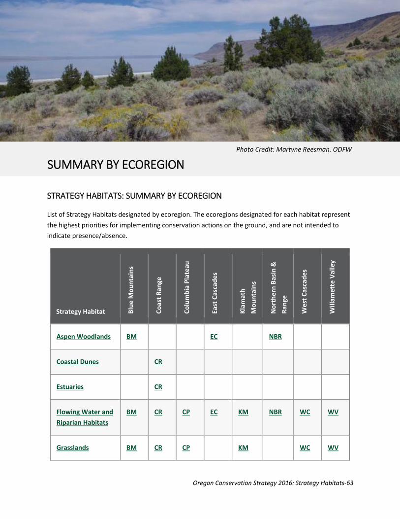
Oregon Conservation Strategy 2016: Strategy Habitats-63
STRATEGY HABITATS: SUMMARY BY ECOREGION
List of Strategy Habitats designated by ecoregion. The ecoregions designated for each habitat represent
the highest priorities for implementing conservation actions on the ground, and are not intended to
indicate presence/absence.
Strategy Habitat Blu
e M
ou
nta
ins
Co
ast
Ran
ge
Co
lum
bia
Pla
teau
East
Cas
cad
es
Kla
mat
h
Mo
un
tain
s
No
rth
ern
Bas
in &
Ran
ge
We
st C
asca
de
s
Will
ame
tte
Val
ley
Aspen Woodlands
BM
EC
NBR
Coastal Dunes
CR
Estuaries
CR
Flowing Water and
Riparian Habitats
BM
CR
CP
EC
KM
NBR
WC
WV
Grasslands
BM
CR
CP
KM
WC
WV
SUMMARY BY ECOREGION
Photo Credit: Martyne Reesman, ODFW

Oregon Conservation Strategy 2016: Strategy Habitats-64
Strategy Habitat Blu
e M
ou
nta
ins
Co
ast
Ran
ge
Co
lum
bia
Pla
teau
East
Cas
cad
es
Kla
mat
h
Mo
un
tain
s
No
rth
ern
Bas
in &
Ran
ge
Wes
t C
asca
des
Will
ame
tte
Val
ley
Late Successional
Mixed Conifer
Forests
BM
CR
EC
KM
WC
Natural Lakes
BM
CR
CP
EC
KM
NBR
WC
WV
Oak Woodlands
CR
EC
KM
WC
WV
Ponderosa Pine
Woodlands
BM
EC
KM
Sagebrush
Habitats
BM
CP
EC
NBR
Wetlands
BM
CR
CP
EC
KM
NBR
WC
WV

Oregon Conservation Strategy 2016: Strategy Habitats-65
Some natural communities and landscape features are not adequately represented through Strategy
Habitats. These communities and features often occur at the local scale and have a patchy distribution
across the landscape. They may be difficult to map from satellite data and may not be represented well
in those datasets. Some communities are highly specialized to the local environment and host a suite of
rare or endemic species. To address the conservation needs of these communities and their associated
species, “local and specialized habitats” were determined through review of geographic vegetation data,
rare plant or animal occurrences, importance to Strategy Species, and occurrences of animal
concentrations, such as migrating or wintering birds.
ALPINE HABITATS: MEADOWS, DWARF SHRUBLANDS, ALPINE TUNDRA, AND WHITE BARK PINE
Ecoregions BM, EC, KM, NBR, WC
Comments Alpine habitats provide important foraging and breeding areas for many
mammals and birds as well as critical resources for birds during migration
periods. They are especially at risk as the climate changes and as recreational
demand increases. Alpine habitats provide important resources for many at-risk
species, such as white bark pine that is particularly vulnerable to white pine
blister rust, outbreaks of mountain pine beetles, and fire suppression resulting
in replacement by more shade-tolerant tree species.
Conservation Actions Support efforts to address climate change and to provide refugia for fish and
wildlife. Manage recreation, human disturbance, and domestic sheep grazing to
minimize impacts to plant communities. Monitor and control invasive plants.
Re-introduce fire into the ecosystem as feasible and appropriate to the local
area.
SPECIALIZED AND LOCAL HABITATS
Photo Credit: Janna Nichols

Oregon Conservation Strategy 2016: Strategy Habitats-66
AQUATIC VEGETATION BEDS
Ecoregions All
Comments Habitat for invertebrates that are the base of the aquatic food chain
Conservation Actions Retain and restore natural water flow regimes. Control invasive plants such as
reed-canary grass. See Flowing Water and Riparian Habitat.
ASH FLOWS AND ASH BEDS
Ecoregions BM, EC, NBR
Comments Habitat for endemic and other rare plants, and important fossil localities
Conservation Actions Manage grazing, mining, and off-highway vehicle use to minimize conflicts with
rare plants.
BALDS AND BLUFFS
Ecoregions BM, CR, EC, KM, WC, WV
Comments Habitat for unique plant communities and invertebrates such as butterflies. In
the Coast Range ecoregion, includes coastal bluffs and headlands. In the
Klamath Mountains ecoregion, includes serpentine barrens and outcrops.
Conservation Actions Control encroaching conifers and shrubs at priority sites. Monitor for and
control key invasive plants at priority sites. In serpentine barrens, minimize
disturbance (e.g., trail or road construction) to rare plant communities.
BAYS
Ecoregions CR, NS
Comments Winter habitat for waterfowl and other waterbirds. Rearing area for juvenile
anadromous salmonids.
Conservation Actions Provide areas of low disturbance during critical time periods. Also see Estuaries.
Oregon Conservation Strategy 2016: Strategy Habitats-67
BITTERBRUSH COMMUNITIES
Ecoregions BM, EC, NBR
Comments Bitterbrush is an important habitat component that provides forage, cover, and
nesting habitat for a variety of wildlife. In the Northern Basin and Range
ecoregion, bitterbrush is found in canyons, often in areas with more moisture,
in a mosaic with sagebrush and rabbitbrush.
Conservation Actions Continue restoration efforts. Improve understanding of bitterbrush
regeneration methods.
CANYON SHRUBLANDS
Ecoregions BM, CP, EC, NBR
Comments Also known as moist deciduous shrublands, these areas provide nesting habitat
for songbirds, and winter habitat for Sharp-tailed Grouse.
Conservation Actions Maintain healthy stands and restore degraded stands. Some degraded stands
can benefit from prescribed fire, removal of encroaching invasive junipers, or
management of grazing season timing.
CAVES AND OLD MINES
Ecoregions BM, CR, EC, KM, NBR, WC
Comments Habitat for rare invertebrates and cave-roosting bats, such as Townsend’s big-
eared bat and several Myotis species. In the East Cascades ecoregion, includes
lava tubes.
Conservation Actions Use gates or seasonal closures to protect known roost sites from recreational
caving and other disturbance. When mines are closed for human safety, provide
for bat entry and exit.
Oregon Conservation Strategy 2016: Strategy Habitats-68
CHAPARRAL AND CEANOTHUS SHRUBLAND
Ecoregions BM, CR, KM, WC, WV
Comments Nesting and foraging habitat for songbirds. Important for kingsnakes, some
butterflies, and other invertebrates. May occur in early successional habitats or
at high elevations, where temperatures and other factors inhibit tree growth. In
the Klamath Mountains ecoregion, it is often removed as a fire hazard. It is
increasingly removed with development, particularly in lowland valleys. Where
not removed, often it becomes senescent without the fires needed for
regeneration. Unusual habitat in the Willamette Valley, which makes existing
sites important for local diversity.
Conservation Actions Maintain shrub diversity during forest management activities. Delay replanting
with conifers where shrub habitat is limited. Control key invasive plants (e.g.,
Scotch broom and Armenian (Himalayan) blackberry) at priority sites.
EELGRASS BEDS
Ecoregions CR, NS
Comments Basis for aquatic food chain. Important rearing area for juvenile fish, including
commercially important species. Foraging habitat for Black Brant.
Conservation Actions Maintain and restore eelgrass habitats. Also see Estuaries.
FEN PEATLANDS
Ecoregions BM, EC, WC
Comments Fens are peat-accumulating wetlands that form where groundwater discharge is
low but constant, and where appropriate geologic conditions occur, such as
glacial plus pumice deposits. Fens provide habitat for sensitive plant species and
provide long-term carbon storage in the form of peat. They are highly sensitive
to climate change, which may reverse the process of peat accretion and lead to
carbon loss.
Conservation Actions Maintain groundwater recharge areas, especially at higher elevations. Use
conservation incentives, and where applicable, maintain existing protection
standards to provide buffers around fen area. Seek opportunities to enhance
recharge from local aquifers supporting the fens.

Oregon Conservation Strategy 2016: Strategy Habitats-69
FOREST OPENINGS
Ecoregions CR, EC, WC
Comments Forest openings provide essential structural complexity and plant diversity.
These structures provide foraging and nesting habitat for Olive-sided
Flycatchers, Willow Flycatchers, and Common Nighthawks. Open areas with
snags are important for Purple Martins and Western Bluebirds. Clouded
salamanders live in large logs and stumps in openings, and their populations
increase following wildfires. Disturbances, such as wildfire, disease, and insect
outbreaks, reset succession and often result in large or small openings with high
forb and shrub diversity and structure (e.g., large snags and logs). With
management emphasis on older successional stages on public land and more
intensive management of private forestlands, openings with structural
complexity and plant diversity are now rare. This has resulted in a loss of nesting
and foraging habitat for some songbirds.
Conservation Actions During salvage logging or other timber harvest, minimize ground disturbance,
and maintain and create snags and downed logs. Look for opportunities to
create forest openings and maintain natural forb, grass, and shrub species.
Openings of 5 acres or greater provide the most benefit to songbirds and other
wildlife. Control key invasive plants in openings. After burns, reseed with native
grasses and forbs, and delay replanting with conifers. Carefully evaluate salvage
logging in burned late successional forests.
UNIQUE GRASSLAND HABITATS
Ecoregions EC, NBR
Comments Includes alkali grasslands, perennial bunchgrass, and montane grasslands.
Important for raptors, grassland birds, and rare plants.
Conservation Actions Maintain and restore these features using site-appropriate tools. Monitor for
invasive species. Manage grazing to minimize impacts to native species.

Oregon Conservation Strategy 2016: Strategy Habitats-70
GREASEWOOD FLATS AND WASHES
Ecoregions BM, CP, EC
Comments Typically found in flats, washes, and terraces with saline soils and shallow water
tables. They flood intermittently, but remain dry for most growing seasons, and
provide habitat for rare plants. High estimated habitat loss in the Blue
Mountains ecoregion but still common in Baker and Grande Ronde Valleys. Very
high estimated loss in Columbia Plateau (greater than 96 percent) and East
Cascades (greater than 9 percent) ecoregions.
Conservation Actions Maintain and restore greasewood habitats. In Blue Mountains, include black
greasewood habitats when managing for a mosaic of valley bottom habitats.
INLAND DUNES
Ecoregions CR
Comments Includes unvegetated to moderately vegetated (10-30 percent plant cover),
active, and stabilized dunes. Habitat for reptiles, small mammals, and rare
plants.
Conservation Actions This habitat type currently has few limiting factors but could be impacted by
uncontrolled off-highway vehicle use in the future. Monitor priority sites.
INTER-DUNAL LAKES AND WETLANDS
Ecoregions CR
Comments Shallow lakes and wetlands located in areas between coastal sand dunes. These
habitats are outcroppings of the water table, so water levels are controlled by
hydrology of the unconfined sand dune aquifers which are recharged by local
precipitation. These wetlands support breeding habitat for Strategy Species,
including northern red-legged frogs and wetland plant communities.
Conservation Actions Maintain groundwater recharge areas at sand dune aquifers. Protect from off-
road vehicle use and other impacts.

Oregon Conservation Strategy 2016: Strategy Habitats-71
INTERTIDAL MUDFLATS
Ecoregions CR, NS
Comments Foraging habitat for shorebirds; critically important during migration. Habitat for
invertebrates such as clams.
Conservation Actions Manage water flows to maintain mudflat habitats. Maintain or restore water
quality and natural sedimentation patterns to maintain habitat quality for
invertebrates. See Estuaries.
MOUNTAIN MAHOGANY WOODLAND AND SHRUBLAND
Ecoregions BM, EC, NBR
Comments Mountain mahogany communities may spread with fire suppression but depend
on fire for long-term maintenance. Expanding in some areas but lacking
regeneration in others. Threatened by juniper encroachment in some areas,
especially in Northern Basin and Range. Many stands have non-native
understory vegetation. In East Cascades ecoregion, mountain mahogany is more
diverse than other ecoregions. Here, it includes birchleaf mountain mahogany,
which covers moist shrublands in the southern portion of the ecoregion.
Mountain mahogany is important nesting habitat for birds because it provides
tree structure in open shrub-dominated landscapes.
Conservation Actions Develop methods to manage mahogany stands and encourage regeneration.
Restore understory vegetation at priority sites.
OFF-CHANNEL HABITAT
Ecoregions All inland ecoregions
Comments Provides critical habitat for juvenile salmonids and other fish, western pond
turtles, freshwater mussels, dragonflies, and other invertebrates.
Conservation Actions Raise awareness so that activities can be managed for minimal impact. Maintain
current off-channel habitat and restore, where possible. Maintain or restore
stream hydrology. Manage beaver populations to provide for beaver-created
habitats, while minimizing conflicts with other land uses. See Flowing Water
and Riparian Habitat.
Oregon Conservation Strategy 2016: Strategy Habitats-72
OFF-SHORE ROCKS (E.G., SEA STACKS)
Ecoregions CR, NS
Comments Critical nesting habitat for seabirds. Haul-outs for marine mammals. Roosting
areas for Peregrine Falcons.
Conservation Actions Implement existing restrictions and continue successful outreach efforts to
minimize disturbance during sensitive nesting and pupping seasons.
PORT-ORFORD CEDAR FORESTS
Ecoregions KM
Comments Endemic to Klamath Mountains; associated with serpentine soils and
characterized by unusual plant and animal associations. Severely impacted by
the invasive Port-Orford root-rot, particularly near the coast.
Conservation Actions Maintain existing habitat. Minimize vehicular traffic and/or new road
construction where potential exists to spread the invasive root pathogen.
ROCK HABITATS: CLIFFS, RIMROCK, ROCK OUTCROPS, AND TALUS
Ecoregions BM, CR, CP, EC, KM, NBR, WC, WV
Comments Habitat for Peregrine Falcons and other cliff-nesting birds, cliff-roosting bats,
rare plants, and wildlife that use rocks for shelter and/or foraging areas. Talus is
habitat for Larch Mountain salamander, pika, and unusual invertebrates. In the
Willamette Valley, hibernacula for snakes, including western rattlesnakes. In dry
ecoregions, rock habitats are particularly important for salamanders as a refuge
from hot, dry weather.
Conservation Actions These habitats have few limiting factors in most ecoregions. In the East
Cascades, residential development at the edge of rims alters vegetation and
disturbs nesting birds. Work with local planners to implement existing setback
distance standards. Rock mining should be avoided in talus areas where known
populations of Larch Mountain salamander and rare invertebrates occur. For all
ecoregions, if important roosts or nest sites are known, minimize disturbance
(such as rock climbing) during the breeding season.

Oregon Conservation Strategy 2016: Strategy Habitats-73
ROCKY SHORE AND TIDEPOOLS
Ecoregions CR, NS
Comments Rocky shores are habitat for marine invertebrates and shorebirds, such as Black
Oystercatcher, Rock Sandpiper, and Surfbird. Tidepools are habitat for marine
invertebrates and fish.
Conservation Actions Minimize disturbance during shorebird nesting season. Work with local
communities and land management agencies to minimize impacts from tidepool
viewing.
SALT DESERT SCRUB
Ecoregions NBR
Comments This low-to-medium shrub habitat can be found on dry sites with saline soils,
such as dry lake beds, flat desert pavements, low alkaline dunes, around playas,
or on gentle slopes above playas. It provides habitat for kit fox and suits reptile
and small mammal species that are primarily or exclusively associated with this
habitat.
Conservation Actions Cheatgrass invasion and increasing surface fuel accumulation are problems at
some locations. Microbiotic soil crusts are particularly critical in these habitats,
so it is important to minimize activities that cause soil disturbance.
SAND SPITS, SAND BARS, AND SPARSELY VEGETATED ISLANDS
Ecoregions CR, EC, NBR, NS
Comments Sparsely vegetated sandy habitats that are isolated from disturbance due to
humans and mammalian predators are important roosting and nesting sites for
colonial waterbirds, such as American White Pelicans, Brown Pelicans, and
Caspian Terns. In eastern Oregon, this habitat occurs around large lakes and
wetlands. Sparsely vegetated island habitat can be surrounded by either
saltwater or freshwater.
Conservation Actions Maintain open habitat characteristics and minimize disturbance at key sites.

Oregon Conservation Strategy 2016: Strategy Habitats-74
SPRINGS, SEEPS, AND HEADWATERS
Ecoregions All inland ecoregions
Comments Habitat for amphibians, invertebrates, and rare plants. The isolated nature of
springs is one of the factors resulting in high levels of invertebrate endemism in
the East Cascades. In dry ecoregions, spring and seep habitats are important as
a source of water for wildlife and as habitat for amphibians and invertebrates.
These habitats have been impacted by livestock watering and agricultural uses.
Conservation Actions Use incentives, and where applicable, maintain existing protection standards to
provide buffers around springs, seeps, and stream headwaters during forest
management and road building activities. Maintain groundwater recharge
areas. Use open-bottomed culverts or bridges when building roads or upgrading
culverts to allow fish and amphibian passage. In dry ecoregions, use cooperative
incentive programs to fence spring heads, which provides benefits to wildlife
but allows water to be available for other uses.
SPRING-FED STREAMS
Ecoregions BM, EC, KM, WC, WV
Comments Streams dominated by groundwater rather than surface runoff have nearly
constant discharge, low water temperatures, and distinct geomorphologic
characteristics, such as few or no gravel bars and wood which remains in the
channel. These streams support cool-water species such as bull trout and may
provide refugia for other temperature-limited species.
Conservation Actions Maintain groundwater recharge areas, especially at higher elevations. Maintain
and restore natural water flow regimes. Maintain supporting aquifers.
Oregon Conservation Strategy 2016: Strategy Habitats-75
WESTERN JUNIPER SAVANNA WITH MATURE TREES; LATE SUCCESSIONAL WESTERN JUNIPER WOODLANDS
Ecoregions BM, CP, EC, NBR
Comments Western juniper savanna consists of scattered, often large, juniper trees within
shrub-steppe. Late successional juniper woodlands may have a higher density of
trees but are characterized by large-diameter trees. These juniper habitats are
important for songbirds and raptors. In the Columbia Plateau ecoregion, the
remaining Ferruginous Hawk nest sites are primarily juniper trees.
Currently, about 3-5 percent of Oregon’s juniper woodland is considered late
successional. A high percentage of old-growth juniper in Central Oregon near
Bend, Redmond, and Madras has been lost. Remaining stands are highly
fragmented and are threatened by encroaching small junipers. In contrast,
recruitment of juniper in sandy shrub-steppe of the Columbia Plateau is
naturally poor, so young juniper trees are not replacing older ones lost to
cutting or natural death.
Conservation Actions Remove small-diameter encroaching juniper trees while maintaining larger
diameter junipers and connectivity of juniper patches. Reintroduce fire where
practical. Need better spatial data on distribution of mature juniper savanna. In
the Columbia Plateau, maintain existing large juniper trees and examine factors
affecting tree recruitment. Research is underway to determine the age,
composition, structure, and wildlife usage of old growth juniper woodlands (for
more information, see the Eastern Oregon Agricultural Research Center
website).
WESTERN LARCH FOREST AND WOODLAND
Ecoregions BM, EC
Comments Occurs on cool, moist sites interspersed with ponderosa pine habitats; may have
been much more common historically in the Blue Mountains ecoregion.
Conservation Actions Maintain large-diameter larch trees and patches of larch forest to provide local
diversity. Control key invasive plants.

Oregon Conservation Strategy 2016: Strategy Habitats-76
Native habitats provide many values for people, fish, and wildlife in Oregon. In the last few decades,
great progress has been made in understanding how Oregon’s habitats function. In addition,
landowners, land managers, and restoration experts have learned on-the-ground lessons through
experimentation and sharing information. However, there are still data gaps that need to be addressed
in order to effectively restore and manage native habitats in Oregon. Below are some broad themes for
data gaps identified for Strategy Habitats. This list is not meant to be comprehensive, but represents
some high priority information needs.
ALL HABITATS
Determine disturbance factors (e.g., fire, flooding, winter storms) and regimes that historically
maintained Strategy Habitats.
Increase understanding of how to manage habitats at multiple scales. For example, improve
methods for managing wetland and riparian habitats across landscape and watershed scales.
Continue to refine habitat distribution maps. Improve ability to map specialized and local
habitats.
Continue to update historical vegetation maps as additional information is developed regarding
temporal and spatial ecosystem dynamics.
Develop innovative management techniques and markets with potential to support job creation
and local economies while restoring habitats (e.g., markets for small-diameter trees removed
during forest restoration).
Establish propagation methods for native plants for restoration. Collaborate with partners to
develop sustainable markets for native plant producers in order to provide a reliable supply of
restoration materials (e.g., Native Seed Network’s programs).
HABITAT DATA GAPS
Photo Credit: Keith Kohl, ODFW

Oregon Conservation Strategy 2016: Strategy Habitats-77
Determine most effective methods to restore natural hydrological conditions to streams, rivers,
and wetlands, including seasonal wetlands (e.g., vernal pools, wet prairies, and playas).
Determine distribution and spread rates of priority invasive species.
Develop measurable indicators of high quality habitat.
Improve our ability to measure the change in habitats, as well as our ability to measure habitat
quality and habitat quality indicators.
Increase our understanding of how management decisions impact habitats. For example,
continue development of state-and-transition models.
TERRESTRIAL HABITATS
Improve bitterbrush and mountain mahogany regeneration.
Control encroaching native vegetation (e.g., conifers in oak woodlands, western juniper in
sagebrush) and effects on native plant composition and ecological function (e.g., transpiration
impacts on surface water flows caused by western juniper).
Reintroduce natural fire regimes into forested habitats and reduce wildfire risk while
maintaining late successional habitats.
Reintroduce fire into fire-dependent landscapes, such as native grasslands, chaparral, oak
savannas, and ponderosa pine habitats. Develop fire prescriptions to address the constraints of
surrounding land uses, smoke management, safety, and other considerations.
Address wildfire in areas with mid-term fire (30-70 year) fire return intervals, such as shrub-
steppe and old-growth forest habitats, where it can be especially damaging to the wildlife
habitat, and prescribed fire may not always be possible.
Maintain fire-dependent habitats in the absence of natural fire regimes, especially where
prescribed fire is not practical.
Oak Woodlands and Savanna
Enhance cavity development in oak trees (e.g., fungal inoculations, limbing).
Determine effectiveness of snag creation from competing conifers to provide cavity-nesting
habitat for oak-associated birds, such as the Western Bluebird, Acorn Woodpecker, and White-
breasted Nuthatch.
Encourage large, open-structure Oregon white oak tree growth.
Evaluate effects of management practices on natural oak regeneration.

Oregon Conservation Strategy 2016: Strategy Habitats-78
Aspen Woodlands
Determine the effects of altered subsoil water levels on aspen.
Utilize prescribed fire techniques that can be applied in aspen habitats to control junipers while
stimulating aspen shoots.
Ponderosa Pine Woodlands
Determine desired patch size and connectivity across landscapes.
Determine gap dynamics (e.g., how forest openings are created, maintained, change over the
landscape, and are used by or affect wildlife).
For high-elevation ponderosa pine habitats that have converted to mixed-conifer habitats,
determine if restoration is possible and desirable. If so, investigate restoration methods.
AQUATIC HABITATS
Determine specific requirements for large woody debris levels in streams.
Identify factors that impact channel stability and channel conditions.
Understand and assess effects of changes in channel geometry.
Assess historical temperature and water quality regimes.
Improve methods to understand impacts of upland management on aquatic habitats.
To ensure effective management of non-point source pollutants, such as fertilizers and
pesticides:
o Understand the chemical breakdown of pollutants in wetlands and other temporary
aquatic habitats.
o Investigate potential impacts of pesticides or herbicides on ecological communities,
considering trophic dynamics.
o Compile management suggestions for reducing the impact of non-point source
pollution.
o Develop non-toxic alternatives to pesticides and fertilizers, where feasible.
MULTIPLE-OBJECTIVE RESOURCE LANDS
Develop decision-making tools to help land owners and land managers assess and compare the
short-term and long-term risks to wildlife and habitat of forest management practices that
reduce the risk of uncharacteristic fire.

Oregon Conservation Strategy 2016: Strategy Habitats-79
Determine the impacts of intensive vegetation management (through herbicides and fertilizers)
on native wildlife and ecological communities.
Increase efforts to understand and evaluate the benefits of managed farm and rangeland (for
example, soil and ecological processes; ability to adapt to change).
Investigate grazing regimes that are compatible with grassland conservation goals.
Investigate impacts of range management regimes on big sagebrush habitats, understanding
what habitat components are important to wildlife and how grazing or other activities affect
these habitats.
Evaluate management actions on range and other land to determine best practices.
Evaluate efficiency with which runoff and irrigation water is used, and evaluate the degree to
which farm and range land resist erosion and runoff.
Determine relationships between groundwater withdrawals and surface water volume.
Develop quantitative measures of environmental condition and performance for managed
landscapes, including managed forests, agricultural lands, rangelands, and urban areas.
Increase understanding about the ecological effects of urbanization, and ways to minimize
negative consequences for species and habitats within and beyond the urbanized footprint.
Improve our understanding of climate change and how:
o it may impact our ability to maintain native habitat.
o to increase resiliency of habitats.
o we can best allow for movement and migration of wildlife.