Embed Size (px)
Citation preview

1
Table of Contents
Section 1 Introduction
Section 2 Goals
Section 3 Background Analysis
Section 4 Land Use
Section 5 Community Facilities
Section 6 Economic Development
Section 7 Tourism/Recreation
Section 8 Transportation
Section 9 Housing
Section 10 Environment
Section 11 Future Land Use
Section 12 Community Facilities Plan
Section 13 Transportation Plan

2
List of Tables and Figures ILLUSTRATION TITLE ____ PAGE NUMBER Figure 1.1 Regional Context 5
Table 3.1 Regional Population Trends 9
Figure 3.1 Cincinnati-Northern KY MSA 10
Table 3.2 Cincinnati-Northern KY Population Trends 10
Figure 3.2 Kentucky Population Trends 11
Table 3.3 Projected Regional Population Trends 13
Table 3.4 Projected Total Households in Pendleton County, 2010-2020 13
Table 3.5 Projected Avg Household Size in Pendleton County, 2010-2020 13
Table 3.6 Pendleton County Population by Age, 2010-2020 14
Table 3.7 Estimate of Components of Resident Population, 2010-2016 14
Table 3.8 Pendleton County Employment by Industry, 1970-2000 16
Table 3.9 Pendleton County Employment by Industry, 2012 16
Table 3.10 Economic Trends 17
Table 3.11 Total & Avg Earning of Persons employed within Pendleton County 18
Table 3.12 % Out Commuting State 19
Table 3.13 % Out Commuting Region 19
Table 3.14 Commuting Trends, 2009-2013 20
Table 3.15 Commuting Times, 2011-2015 20
Table 3.16 Home Statistics in Region, 2011-2015 22
Figure 3.5 Cost of Community Services 22
Table 3.17 Regional Agricultural Trends, 2017 24
Table 3.18 Education Statistics in Region, 2011-2015 31
Figure 3.6 Licking River Watershed 34
Figure 11.1 2012 Future Land Use Map 59
Figure 11.2 Falmouth Future Land Use 60
Figure 11.3 Butler Future Land Use 61
Figure 11.4 Butler Flood Map 62
Figure 11.5 Falmouth Flood Map 63
Figure 11.6 Pendleton County Flood Map 64
Reference Materials 78

3
Section 1: Introduction
Pendleton County, which includes the cities of Falmouth and Butler, is located in north central Kentucky and is included in the Cincinnati/ Northern Kentucky Metropolitan Statistical Area. This primarily rural county is approximately 279 square miles (178,000 acres) in area, making it one of the smaller counties in the Commonwealth. The counties of Kenton and Campbell lie to the north, Bracken to the east, Harrison to the south, and Grant to the west. Pendleton County is the approximate mid-point between Cincinnati, Ohio and Lexington, Kentucky. The County is located in the Bluegrass physiographic region. The long ridge-tops and short slopes indicate the limestone, shale, and siltstone that lie directly below the surface. The landscape ranges from very steep slopes to relatively flat floodplains.
The South Fork Licking River and the Licking River join in Pendleton County at the site of Falmouth. These two rivers drain most of the area into the Ohio River that runs to the north of the County.
Role of the Comprehensive Plan A Comprehensive Plan is a statement of the community’s goals and objectives. The Plan expresses where the community is today and where it desires to be in the future, with recommendations on how to progress there. As such, the plan is a guide to decision making, a foundation for more detailed planning efforts. The plan may be implemented through a Capital Improvements Program, annual budgets, smaller scaled and more detailed plans, day-to-day operations, and through the efforts and resources of private citizens, businesses, and organizations.
In Kentucky, the comprehensive plan is also a legal document that satisfies numerous statutory requirements. State law KRS 100 requires this plan to be updated every five years.
The plan can serve as a good general introduction to community issues for a new resident, staff member, planning commissioner, or elected official.
The Comprehensive Plan is not a fixed document, but rather part of an ongoing planning and implementation process. Because conditions and circumstances are constantly changing, planning efforts must continuously be reevaluated and adjusted.
Update Process This Comprehensive Plan was rewritten over an eight month period in late 2005 and 2006. In 2005 the Fiscal Court contracted with the University of Kentucky Landscape Architecture Department to have their 5th year students prepare a “vision” study for the community. The resulting study entitled “Pendleton County: The Best of Both Worlds,” was referenced in preparing this Comprehensive Plan. The Comprehensive Plan was updated in 2012 and 2017 as part of the five (5) year update/amendment process required by KRS 197.197.

4
I-7
5
Figure 1.1 Regional Context
Indiana Ohio
Cincinnati
Boone Campbell
Kenton Gallatin
Pendleton Bracken Carroll Grant
Owen Harrison Note: The listed counties comprise the “region” referred to in this plan.
Planning History in Pendleton County
Pendleton County has three governing bodies: the Pendleton County Fiscal Court, and the City Councils of Butler and Falmouth. The members of each of these three governing bodies are elected by their constituencies. The members of the City Councils are elected by the residents of their respective cities, and the members of the Fiscal Court are elected by the residents of Pendleton County. In the 1980's, the three governing bodies of Pendleton County agreed to form a joint planning commission to serve all three bodies. The Planning Commission is known as the Pendleton County Joint Planning Commission. The Planning Commission consists of nine members, five of whom are appointed by the Fiscal Court, and two of which are appointed by each of the two city councils. The Planning Commissioners serve four-year terms, and the terms are staggered so that there are a couple of Commissioners whose terms expire each year and are up for reappointment or replacement. The Planning Commissioners elect officers to serve the Planning Commission from amongst themselves. The Commission adopts bylaws to govern their activities. The Planning Commission meets monthly on the last Monday of the month. They receive no compensation for their service. The selection of the membership of the Planning Commission is in the hands of the elected officials of the governing bodies. The Planning Commissioners are required to be in compliance with the applicable rules of ethics in place in the community.

5
In 2001, the three governing bodies agreed to reaffirm their commitment to a joint planning commission for Pendleton County and passed ordinances doing so. In 2002, the Planning Commission adopted a Pendleton County Comprehensive Plan. In the comprehensive planning process, the Planning Commission recognized the increased development occurring within the county, some of which was being done with substandard design and construction of infrastructure (streets, sidewalks, sewers, waterlines, etc.). After construction of this substandard infrastructure, the governing bodies were required to accept dedication of these facilities and provide maintenance to them. Due to the substandard design and construction of such infrastructure, the maintenance costs being imposed upon the governing bodies was significantly increasing, and significantly affecting their budgets and their financial ability to provide proper maintenance to these facilities. In 2003, the Pendleton County Joint Planning Commission adopted Subdivision Regulations to regulate the division of land in the county into parcels, and to establish minimum design and construction standards for infrastructure to be dedicated to the governing bodies. In 2007, 2012, and 2017, the Pendleton County Joint Planning Commission recognized its statutory obligation to update the Comprehensive Plan, which is required to be updated at a minimum of every five years. To begin the 2007 update process, the Planning Commission, in conjunction with the Fiscal Court, formed a Steering Committee of citizens to participate in the process of establishing policies for the updated Comprehensive Plan. The Steering Committee's vision ultimately led to the Goals & Objectives included into the current Comprehensive Plan.
Planning History in Pendleton County At the conclusion of the efforts of the Steering Committee, the Planning Commission proceeded with the drafting and adoption of an updated Comprehensive Plan. The three governing bodies are required to approve any changes to the goals and objectives of the Comprehensive Plan, if they are modified from the 2002 version. The Planning Commission has sole responsibility and authority with regard to all other elements of the Comprehensive Plan. After the adoption of the 2007 Comprehensive Plan Update, the Pendleton County Fiscal Court adopted a Zoning Ordinance for Unincorporated Pendleton County in 2008. The Falmouth City Council also adopted a Zoning Ordinance in 2010. Each body only has authority to implement regulations on the area within their geographic boundaries. To begin the 2012 update process, the Planning Commission distributed a community survey to allow citizens input on community direction and needs. In conjunction with the survey, the Planning Commission interviewed community leaders and entrepreneurs to gather perspective on future growth and needs in the county. The results of which are incorporated into the 2012 Comprehensive Plan Update. In 2012, the Falmouth City Council contracted with the University of Kentucky Landscape Architecture Department to have their 4th year students prepare a land use study for the City of Falmouth US 27 Corridor.

6
Section 2: Goals
The Importance of Goals The primary purpose of a comprehensive plan is to provide policy direction to a community on issues of growth, development and preservation.
The role of this Plan’s goals and objectives is to describe the vision residents and leaders of the County have for their community and to indicate the direction change should take in the future.
These Goals reflect the desires of the community. It should be noted that all of these goals are interrelated.
Note: for specific discussion and objectives and implementation actions, see the appropriate section.
1. Community Image: Pendleton County is rooted in traditional values, yet has a
progressive outlook for the future. Preservation of the rural, small town, agricultural and environmental heritage while accepting and managing change is vital to the future of the community. The community is clean, friendly, and offers special opportunities for residents and visitors alike.
2. General Planning: A comprehensive plan will be adopted to ensure a high quality of life and economic vitality in Pendleton County.
3. Growth Management and Land Use Planning: Growth and development in Pendleton County shall be managed for the benefit of the overall community and in a manner that minimizes undesirable impacts of development and change.
4. Agricultural Viability: Agriculture will continue to be a vital element of a diverse economy in Pendleton County.
5. Flood Control: The community will strive to make the Licking River less of a threat and more of a benefit to the quality of life in Pendleton County, Falmouth and Butler.
6. Economic Development: In order to achieve a sustainable economy with quality employment opportunities, Pendleton County will:
a. Promote a sustainable, strong, diverse and healthy economy firmly connected to local, regional, national and global trends; b. Promote the retention and expansion of existing businesses; c. Foster the startup and development of new businesses; d. Create and retain a skilled work force; e. Leverage local assets such as environmental quality, small town/rural atmosphere, outdoor recreation potential and overall quality of life to
keep and attract business to the community.

7
7. Community Facilities: Quality public services and facilities will be provided to
residents and business owners in Pendleton County. 8. Tourism Development: Pendleton County will be the recreational and tourism destination for northern Kentucky. 9. Infrastructure: Strategic infrastructure investments will be made to guide growth, and enhance economic development, tourism, environmental protection and the overall quality of life for residents. 10. Transportation: Plan safe and efficient transportation expansion and improvements that support and compliment the entire Comprehensive Plan. 11. Housing: Housing will be safe, sound and affordable to the existing and future residents of Pendleton County. 12. Public Safety: Residents and visitors of Pendleton County will experience a safe and secure community. 13. Environment: Pendleton County is recognized as a leader in managing, protecting, conserving and enhancing its natural environment. 14. Education: Pendleton County provides comprehensive, innovative and excellent educational opportunities for all residents. 15. Intergovernmental Cooperation: The three municipalities of Pendleton County, Falmouth and Butler will communicate effectively as a means to coordinate service delivery.

8
Section 3: Background Analysis
Introduction
Pendleton County is at a crossroads. The 21st century will place demands upon the leaders and residents of the County unlike any in the previous 200 years of its history. Rapid technological, economic, and social change is occurring, not only in the region, but across the globe. In order to best face this change, the County must understand both its attributes and its unique challenges. That is the purpose of this section: to provide the necessary information with which to begin that process.
Demographics Current Population
Over the course of the 2000’s, Pendleton County had the seventh highest rate of population growth (3.4%) among the ten counties located in Northern Kentucky (Table 3.1). Since 1970, the county’s population has increased 49% – averaging 1,200 new persons added to the population each decade.
Table 3.1 Regional Population Trends
Kentucky State Data Center
County 2000 2010 % Change 2000-2010
Boone 85,991 118,811 38.2
Bracken 8,279 8,488 2.5
Campbell 88,616 90,336 1.9
Carroll 10,155 10,811 6.5
Gallatin 7,870 8,589 9.1
Grant 22,384 24,662 10.2
Harrison 17,883 18,846 4.8
Kenton 151,464 159,720 5.5
Owen 10,547 10,841 2.8
Pendleton 14,390 14,877 3.4
Total 417,679 465,981 11.6
Our population on July 1, 2010 was estimated to be 14,877 according to the 2010 US Census. This represents a 3.4% increase from the 2000 census, and ranks Pendleton County as Kentucky’s 75th most populous.

9
Pendleton County is included in the Cincinnati-Northern Kentucky Metropolitan Statistical Area (MSA). Figure 3.1 shows the extent of the MSA, while Table 3.2 shows the population trends in the MSA. In 2010, the estimated population for the MSA was 2,130,151.
Figure 3.1
Cincinnati–Northern Kentucky MSA
Greater Cincinnati Chamber of Commerce
Table 3.2
Cincinnati-Northern Kentucky Population Trends
2000 MSA Population
2010 MSA Population
% Change
1,979,202 2,130,151 7.6
2010 US Census Bureau

10
Demographics Current Population On July 1, 2010, Kentucky’s population was estimated to be 4,339,367. Figure 3.2 shows population trends in Kentucky between 2000 and 2010. Counties shown in dark green have experienced the fastest population growth. These are primarily located in the outer fringes of the state’s three major metropolitan areas. Pendleton County lies in a band of fast growing counties located on the south end of the Cincinnati- Northern Kentucky MSA.
Figure3.2 Kentucky Population Trends
Kentucky State Data Center
Falmouth
In 2010, Falmouth was estimated to have a population of 2,169 people. This is an increase of 111 people from the 2000 Census figure of 2,058, a 5.4% increase. Falmouth’s population accounts for 14% of the entire County’s total population. The 2010 figure represents a decline in Falmouth’s population from the 1990 figure of 2,378, a total decline of 9.6%. This declining population trend has been occurring at least since 1980 when the population stood at 2,482.

11
Butler In 2010, Butler was estimated to have a population of 612 people. This represents 4.1% of the entire County population. The 2000 census reported a population of 613. Butler’s population has declined since 1980 when the population was recorded at 663.
Components of Current Population Past studies showed in-migration was fueling Pendleton County’s growth. In 2000, 22.3% of Pendleton County’s residents lived outside the county in 1995. Research conducted by University of Kentucky Professor Dr. Lori Garkovich, in 2005, shows significant shifts occurred in Pendleton County’s age structure from 1990 to 2000. First, the pro- portion of the population between the ages of 35-44 increased by 53% and similarly, the proportion between the ages of 45-54 increased 54%. Second, among adolescents there was a 24.4% increase in the population ages 5-9 and a 22.6% increase in the population age 10 to 14. These demographics reflect the in-migration of working-age families. As Dr. Garkovich points out, this is a group that typically moves in search of residential amenities. However, from 2000 to 2010, the population of school aged children has decreased. The 2000 Census showed the County as home to 4,072 children eighteen years old and under (28.3% of the county’s total population).The 2010 Census shows the County as home to 3,675 children eighteen years old and under (25% of the county’s total population). Pendleton County’s 2010 working age population (18 y.o. – 64 y.o.) is 63%, an increase of 2% since 2000. In 2000, the County had 1,510 senior citizens (10.5% of the county’s pop.). In 2010, the County had 1,830 senior citizens (12.3% of the county’s pop.). The last ten (10) year trend demonstrates Pendleton County as an aging population. As of 2010, within the ten county northern Kentucky region, Pendleton County now has the 7th highest proportion of persons age 25+ with at least a high school degree and the 7th highest proportion of persons age 25+ with at least a Bachelor’s degree. In 2010, high school attainment reached 78% of the population age 25 and older. Similarly, those with a bachelor’s degree or higher increased to 10.5%. These figures represent a significant increase from 1990. In 1990, only 60.1% of the population had graduated from high school or attained higher levels of education compared to 64.6% in the state. Further, in 1990, Pendleton County had only 6.8% of people with a bachelor’s degree or higher, which represented only about one-half of the statewide average of 13.6. Pendleton County’s population is almost exclusively white (97.8%), which is consistent with Kentucky’s predominantly white (88%) population in general. African-Americans make up approximately one-half of one percent of the population. People of Hispanic descent make up a larger percentage, 1% of the population.

12
Demographics Components of Future Population
Data released in October 2016 by the Ky State Data Center shows conflicting information from the previous information reflected in the 2012 Comprehensive Plan. The release, the Vintage 2016 Projections of Population and Households, forecast population change through 2040 in 5-year intervals for the State of Kentucky, Kentucky Counties, and Area Development Districts. Table 3.3 below, using Vintage 2016 Projections, shows Pendleton County is projected to lose the highest percentage of population in the 10 county region.
Table 3.3 Projected Regional Population Trends
Kentucky State Data Center
County 2010 2020 Change10-20
Boone 118,811 139,018 17%
Bracken 8,488 8,139 -4%
Campbell 90,336 92,898 3%
Carroll 10,811 10,766 -0.4%
Gallatin 8,589 8,857 3%
Grant 24,662 24,793 0.5%
Harrison 18,846 18,751 -0.5%
Kenton 159,720 169,386 6%
Owen 10,841 10,464 -3.5%
Pendleton 14,877 14,051 -5.5%
Total 478,027 497,123 4%
Table 3.4 Projected Total Households in Pendleton County 2010-
2020
Kentucky State Data Center
2010 2020 % Change
5494 5639 2.6%
Table 3.5 Projected Avg Household Size in Pendleton County 2010-
2020
Kentucky State Data Center
2010 2020 % Change
2.67 2.45 -8.2%

13
Table 3.6
Table 3.7 Estimates of the Components of Resident Population
Change: April 1, 2010 to July 1, 2016
Kentucky State Data Center
Source: US Census Burea, Release Date: March 23, 2017
The 2012 Comprehensive Plan, based on estimates by the 2010 US Census, projected an increase in the number of children up to age 18 from 2010 to 2020 by one-third. However, as previously noted, the 2010 census data showed the percentage of children up to age 18 had fallen from 28% to 25% of the county population. Pendleton County Schools have seen a decline in enrollment since 2008. In the 2016-2017 school year, 2,291 total students were enrolled in the school district; in 2012 there were 2,574 students.
County Total Pop Change
Births Deaths Natural Increase
Total Migration
Boone 9,717 10,308 4,849 5,459 4,258
Bracken -88 653 581 72 -160
Campbell 1,875 6,827 5,151 1,676 199
Carroll -132 996 759 237 -369
Gallatin 20 656 542 114 -94
Grant 261 2,206 1,346 860 -599
Harrison -203 1,300 1,374 -74 -129
Kenton 5,232 14,204 8,673 5,531 -299
Owen -193 650 656 -6 -187
Pendleton -316 1,035 913 122 -438

14
As referenced in Table 3.6, the population continues to age in the county. This information is consistent with data presented in the previous Comprehensive Plan indicating the number senior citizens in the county will double from 2000-2020. The aging population combined with the shrinking household averages indicates Pendleton County is losing its young adults to out-migration. This places an important need for planning to meet the specialized needs of the elderly, but also a critical need to increase economic development and an employment base in our county.
Household Projections
Households in Pendleton County are expected to increase 9% between 2000 and 2020. This represents an increase of 469 new units, from 5,170 in 2000 to 5,639 in 2020. The conclusion is that households are growing faster than the population, however, at a slower rate than previously estimated. The previous estimates from the 2010 US Census Data indicated the households in Pendleton County would increase at a rate of 27% from 2000 to 2020. Increasing household projections are important for many reasons. One is that each new household needs space, decreasing the amount of open space in the County. Two, each new housing unit adds, according to accepted engineering standards, ten new car trips per day to the traffic on the existing road network. Thus, the 469 new housing units predicted by this household projection forecast could, under conventional development patterns, add four thousand new car trips per day to the traffic system. Each new household can add up to 10 car trips per day.
Economic Data Economic activity in Pendleton County is in a significant transition period. Manufacturing and retail trade employment are stagnant and now comprise less than 17% of total employment, while service employment has grown from less than 100 employees in 1970 to nearly 600 in 2000. Growth in government employees grew 31.9% in the same period. Agricultural employment saw a steep decline. See Table 3.8 below. There were 2,285 total jobs in Pendleton County in 2012. In 2012, Public Administration including school and government jobs rose to 30% of the job share in Pendleton County. Services including health, food, waste, professional, and other rose to 579 jobs or 28% of the local job sector. Manufacturing combined with mining has 22% of the job market followed by retail at 8.4%.
15
Table 3.8 Pendleton County Employment by Industry, 1970 - 2000
Five Largest Industries by Number of Employees
Manufacturing Retail Services Government Farming
1970 304 409 n/a 435 1141
1980 903 365 n/a 456 1242
1990 523 481 n/a 587 1172
2000 528 494 599 774 1015
% change 1970-1980 197% -10.8% n/a 4.8% 8.9%
% change 1980-1990 -42.1% 31.8% n/a 28.7% -5.6%
% change 1990-2000 1% 2.7% n/a 31.9% -13.4%
Source: U.S. Census Bureau
Table 3.9 Pendleton County Employment by Industry, 2012 Five Largest Industries by Number of Employees
Manufacturing/Mining Retail Health/Social Government/Public Adm Food, Waste, other Services
504 192 242 684 406 Source: EMSI 2013
Unemployment was estimated to be 8.3% by 2012 and decreased to 4.8% in 2016. The 2016 figure is slightly below both the State (5%) and National (4.9%) unemployment numbers.
PER CAPITA PERSONAL INCOME
Per capita personal income is calculated as the total personal income of the residents of a given area
divided by the population of the area. In computing per capita personal income, BEA uses Census Bureau
mid-year population estimates. Personal income is measured before the deduction of personal income taxes
and other personal taxes and is reported in current dollars (no adjustment is made for price changes).
In 2003 Pendleton County residents had a per capita personal income (PCPI) of $20,801. ThisPCPI ranked 69th in the state and was 78% of the state average of $26,575 and 66 percent of the national average of $31,472. In 2015, the estimated PCPI was $33,951 and ranked 54th in the state. The average annual growth rate from 2014-2015 for the county was 4.1%, 4.1% for the state, and 3.7% for the nation.

16
Household Incomes As of 2010, Within the 10 county region, Pendleton County has the fourth highest median household income ($43,517) and the highest rural median house hold income (Table 3.10). 15% of all persons had incomes below poverty, the 4th lowest poverty rate in the region. But nearly one in four (23%) children under the age of 18 are in poverty in 2010. This is up from (19.7%) in poverty in 2000. Students eligible for free/reduced school lunch have increased 8% since 2000.
Table 3.10
Economic Trends
2010 US Census Bureau
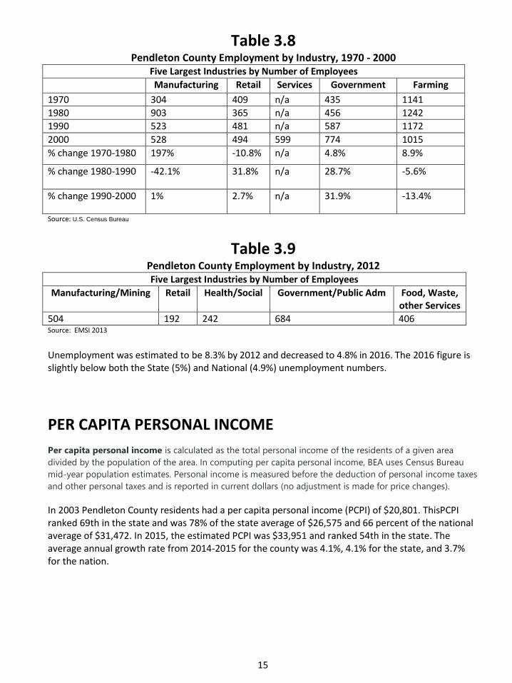
EARNINGS BY PLACE OF WORK Earnings of persons employed in Pendleton County in 2015 were $119,232,000 as referenced in Table 3.11. An increase of 28% from $93,047,000 in 2003, the date of the last referenced data in the Comprehensive Plan. Workers in Pendleton County earned a weekly average of $774 compared to the state weekly average of $834 in 2015.
Name
Poverty Estimate All Ages
Poverty Percent All Ages
Poverty Estimate
Under Age 18
Poverty Percent Under Age 18
Poverty Estimate Ages 5-17
Poverty Percent Ages 5-
17
Median Household
Income
PendletonCounty 2,210 15.0 830 23.0 549 20.3 43,517
BooneCounty 10,895 9.2 3,812 11.5 2,420 10.0 64,005
BrackenCounty 1,389 16.5 518 24.7 319 20.7 42,056
CampbellCounty 11,424 13.0 3,476 17.2 2,274 15.8 47,341
CarrollCounty 2,339 22.3 971 36.8 642 35.3 42,192
GallatinCounty 1,426 16.7 564 25.3 374 22.9 42,761
GrantCounty 4,417 18.4 1,745 26.1 1,173 24.4 42,690
HarrisonCounty 3,077 16.6 1,096 24.4 743 22.3 42,124
KentonCounty 20,906 13.3 7,118 18.3 4,504 16.3 51,049
OwenCounty 1,802 16.7 653 25.1 432 22.5 40,413
17
Table 3.11 Total & Avg Earnings of Persons Employed within Pendleton County, 2015
Description Measure
Total Earning, Wage, Salaries, & Proprietor Income $119,232,000
Wages & Salaries $98,717,000
Supplements to wages & salaries $27,669,000
Employer contributions for employee pension and ins. funds $20,357,000
Employer contributions for government social insurance $7,312,000
Proprietors' income 9/ $20,515,000
Farm proprietors' income -$2,380,000
Nonfarm proprietors' income $22,895,000
Total employment (number of jobs) 4,435
Wage and salary employment 2,488
Proprietors employment 1,947
Average Wage and Salary Earnings $50,798
Average Proprietors' Income $10,537
Source: Bureau of Economic Analysis, Table CA4 Personal Income and Employment by Major Component
Commuting Trends 68.8% of Pendleton County residents commute out of the County for work each day. This ranks Pendleton County 5th highest in the State and the highest percentage in the region. Pendleton County workers have an average commute time of 35.9 minutes, which is nearly twice as long as the shortest time in the region – Carroll County at 18.7 minutes. Pendleton County is ranked second in the state and region to Bracken County in commute time to work. From 2009-2013 an estimated 4,413 Pendleton County workers commuted to other counties. This is 987 Pendleton County Workers commuted to Campbell County, while 867 commuted to Hamilton County, OH. Out-commuting to these two counties alone accounts for over 29% of Pendleton County’s working population.
Bracken County provides the highest number of workers commuting into Pendleton County: 203. The next highest county is Harrison, which sends 193 workers north into the County.
18
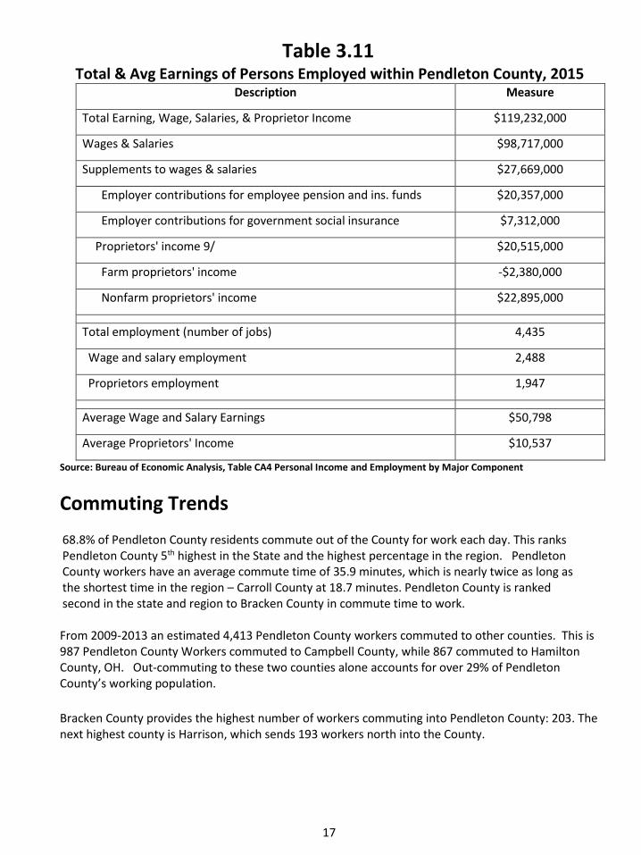
Table 3.12 2011-2015- % Out commuting State
Kentucky 31.5 Rank
Spencer 84.9 1
Edmonson 73.0 2
Garrard 72.6 3
Trimble 70.4 4
Pendleton 68.8 5
Oldham 68.5 6
Livingston 68.4 7
Bullitt 68.3 8
Meade 68.0 9
Grant 67.8 10
Gallatin 67.4 11
Bracken 67.1 12
Henry 64.7 13
Anderson 64.4 14
Campbell 64.0 15
Source Table 3.11 & 3.12) U.S. Census Bureau, 2011-2015 American Community Survey 5-Year Estimates. Commuting Characteristics by Sex.Table
Table 3.13
2011-2015- % Out commuting Region Pendleton 68.8 5
Grant 67.8 10
Gallatin 67.4 11
Bracken 67.1 12
Campbell 64.0 15
Kenton 60.7 22
Owen 55.1 33
Harrison 49.3 44
Boone 43.5 65
Carroll 28.4 96

19
Table 3.14 Commuting Trends 2009-2013
County of
Residence:
# of working in
Pendleton Co. Lives in Pendleton
& Works in:
# of
Workers:
Pendleton 1,948 Pendleton 1,948
Bracken 203 Campbell 987
Harrison 193 Hamilton, OH 867
Campbell 138 Boone 863
Mason 109 Kenton 603
Kenton 79 Grant 444
Grant 77 Harrison 195
Boone 58 Scott 148
Lewis 29 Fayette 99
Hamilton, OH 23 Bracken 78
Brown, OH 21 Philadelphia, PA 47
Macon, TN 16 Butler, OH 20
Fleming 14 Franklin 15
Henry 13 Trimble 12
Henderson 11 Warren, OH 12
Madison 11 Allen, OH 9
Robertson 11 Gwinnett, GA 6
Daviess 2 Denton, TX 6 Source: US Census 2009-2013 ACS 5 yr Est, Commuting Flow
Table 3.15 Commuting Times
KY Counties Mean Travel Time 2011-2015 State Region
Place
Mean Travel Time to Work in Minutes
Travel Time State Rank
Place
Mean Travel Time to Work in
Minutes
Travel Time State Rank
KY 23.0 KY 23.0
Pendleton 35.9 119 Carroll 18.7 5
Christian 17.0 1 Campbell 22.1 36
Calloway 17.5 2 Kenton 23.3 48
McCracken 17.6 3 Boone 24.1 54
Franklin 18.2 4 Harrison 26.2 72
Carroll 18.7 5 Gallatin 27.7 87
Daviess 18.7 5 Owen 29.7 99
Taylor 18.8 7 Grant 30.0 101
Clinton 19.1 8 Pendleton 35.9 119
Hickman 19.3 9 Bracken 37.8 120
20
In addition to “leaking” workers out of the county, Pendleton County currently does not capture the full economic potential of in-county trade. Rather, this economic potential is transferred to other counties in the region as indicated by the following research of Dr. Lori Garkovich. According to this research, Pendleton County has:
The 3rd lowest amount of retail trade.
The second lowest proportion of trade area capture with total sales of $57.7 million (only Bracken had lower total sales at $23.0 million).
More specifically, Pendleton County has:
The lowest share of sector sales for food and beverage stores.
The lowest share of sector sales for generalmerchandise stores.
The second lowest share ofsector sales for home furnishings andappliances.
The 4th lowest share ofsector sales for motor vehicles and parts stores.
The 5th lowest share of sector sales for food service and dining establishments. Dr. Garkovich’s research shows that between 1990 and 2001, despite population and household growth, Pendleton County’s share of trade area capture declined overall. In only one area, food service and dining establishments did Pendleton County’s trade area share increase. One key factor is the fact shown that more than six out of ten employed persons who live in Pendleton County actually work outside the county. This situation has a ripple effect on other aspects of the economy. Since many people are already going out-of-county for employment, they are more likely to stop for their shopping elsewhere. A 2003 Northern Kentucky ADD study confirms this: 71.6 cents of every consumer dollar “leaks out” of Pendleton County. In other words, the merchants of the community capture only 28.4 cents of the nearly $203 million dollars spent by local residents. The ADD study indicates that Pendleton County residents are likely to shop at superstores in other communities. This “leakage” makes it harder for local businesses to compete, further continuing the cycle.
Housing Pendleton County has 6,310 housing units in 2016 according to the estimates of the US Census Bureau. Of those units, 77.5% are owner occupied. The median value of owner-occupied homes in Pendleton County was $104,800 from 2011-2015. The median selected owner costs with a mortgage for a homeowner in Pendleton County from 2011-2015 was $1,115 while the median gross rent from 2011-2015 in Pendleton County was $583. 72% of the homes in Pendleton County are single family detached while 21% are mobile homes. Pendleton County’s housing value is the 6th highest in the 10 county region. Pendleton County has the sixth highest percentage of mobile homes in the region. This fact may help explain the relatively low housing values in Pendleton County, especially compared to other counties in the Northern Kentucky area. (See Table 3.16) These low values may continue to drive housing expansion in the County with potentially undesirable consequences. Recent studies have shown that residential growth rarely provides enough revenue to cover the required service provisions that accompany it.

21
Many of these studies routinely show that housing growth demands a larger investment than it contributes to County revenues. (See Figure 3.5) Low housing values mean low property tax revenues, which do little to offset service demands that all types of housing demand.
Table 3.16
Home Statistics in Region 2011-2015
County Housing Units Owner Occ. Housing
Rate % Median Value Owner
Occ. Housing Unit
Boone 48,774 73.3 $175,100
Campbell 40,174 68.7 $150,400
Kenton 69,812 65.8 $145,200
Grant 10,006 70.4 $124,900
Harrison 8,221 67.3 $113,000
Gallatin 3,834 68.8 $107,500
Pendleton 6,310 77.5 $104,800
Carroll 4,682 60.8 $99,200
Owen 5,639 75.5 $98,000
Bracken 3,829 76.2 $95,800
Figure 3.5
Cost of Community Services
Commercial/ Ag land/ Residential Industrial Open
Graph: Median cost- per dollar American Farmland Trust
of revenue raised–to provide public services to different land uses.

22
Business Climate
Pendleton County has many attributes that are attractive to business. Labor and energy costs are much lower than national and regional averages. The County has a surplus of available labor.
The County has available industrial sites located along U.S. 27. All necessary utilities are available within the County. Over 50 Colleges, Universities, and Technical Schools are located within 60 miles of Pendleton County. Further, the community enjoys low property taxes and low occupational license taxes (1/2 of 1%).
The Community also has a well-organized and aggressive Industrial Development Authority and Economic Development Office dedicated to attracting, retaining, and expanding business within the County. In 2017 Pendleton County was designated as "Work Ready in Progress" by the State of Ky, which certifies the workforce quality of Kentucky counties.
Agriculture
An expected correlation to increasing housing demands is a shift in land use from rural to urban uses. Historically, Pendleton County has been an agricultural community. Yet as expected with the increased housing growth, between 1987 and 2012, the amount of land in farms decreased from 135,728 acres in 1987 to 101,299 acres in 2012. The number of farms in Pendleton County decreased from 949 to 810 or 14.6% during this same period. This occurred as the number of farms in the 10 county region declined from 2002 to 2007 by 3.5% and from 2007 to 2012 by 9.8%. As a result, Pendleton County’s share of farms in the region actually rose from 12.1% in 1978 to 13.5% in 2012. The market value of the agricultural products sold by Pendleton County’s 964 farms was $8.8 million in 2002, averaging $9,130 per farm. The market value of the agricultural products sold by Pendleton County’s 910 farms was $12.4 million in 2007, averaging $13,626 per farm. The market value of the agricultural products sold by Pendleton County’s 810 farms was $11.4 million in 2012, averaging $14,166 per farm. This showed an increase in real dollars from 2002 by approximately $400,000. Operational expenses for Pendleton County’s farmers in 2012 were $12.4 million which includes expenditures for fuel, feed, seed, chemicals, livestock, property taxes, and lease/rental payments. $1 million in expenditure was paid to farm labor in 2012. Pendleton County ranked 80th in the state in market value of agricultural products sold in 2012. The average farm in Pendleton County had a net profit of $967.00 in 2012 according to the USDA Census.
The decrease in land devoted to agricultural squares with the urbanization of the County over the last 20 years with an increasing trend of people seeking “farmettes” as an alternative to conventional suburban development. An interview with the PC Ag Extension Director revealed there will be less tobacco production with an increase of production in soybean, corn, cattle, and wine vineyards. There has been an increase in leased farms showing a trend that fewer landowners are farming. Agro tourism and recreation (horse trails, educational farms, etc) is a growing trend in Pendleton County. Agriculture is becoming more diverse and involves less land for production than traditional farming. Urban gardens, chicken coops, etc are being allowed within city limits in major cities. There needs to be a community emphasis placed on locating a Farmer's Market in the community. (Table 3.17)

23
Table 3.17 Regional Agricultural Trends
2007
Source: Census of Agriculture
2012
County # of Farms Farm
Acreage
% of CountyLand
Used as Farms
Net Farm Income per
farm ($)
Boone County 682 74,750 47 3909
Bracken County 618 100,660 77 4170
Campbell County 535 47,335 49 -1248
Carroll County 326 63,708 77 2428
Gallatin County 204 33,816 52 4009
Grant County 959 114,965 70 -531
Harrison County 1083 161,777 82.5 4828
Kenton County 481 42,544 41.5 -383
Owen County 864 157,932 70 4201
Pendleton County 910 126,968 71 1815
County # of Farms Farm
Acreage
% of County Land Used as
Farms
Net Farm Income per
farm ($)
Boone County 608 67,211 43 -3216
Bracken County 587 86,813 67 162
Campbell County 504 42,164 43 -1929
Carroll County 278 53,562 64 4873
Gallatin County 185 27,783 44 2790
Grant County 812 98,372 59 -756
Harrison County 1064 164,457 83 2620
Kenton County 459 38,144 37 -7545
Owen County 701 131,959 59 4025
Pendleton County 810 101,299 57 967

24
Infrastructure Water Service There are currently four providers of water service in Pendleton County. They areas follow: the City of Falmouth, the Pendleton County Water District, the East Pendleton County Water District, and the Bullock Pen system. The four providers service over 4,406 households and businesses. The main source of water in Pendleton County is the Licking River. In terms of both quantity and quality, the Licking River is a reliable source and is expected to remain so into the foreseeable future. The city of Falmouth obtains its water from the Licking River and sells a portion of it to the rural water districts. Pendleton County Water District also purchases water from Northern Kentucky Water District to supply a portion of its customers as well as the entire city of Butler. Falmouth’s water treatment plant has a capacity of treating 2.1 million gallons per day. Current users demand less than 1 million gallons per day, leaving a significant excess capacity. However, the facility is aging and will have extensive rehabilitation needs in the near future.
Waste Water Treatment Pendleton County has limited wastewater treatment facilities, service being limited to the urban areas in and around Falmouth and Butler. The City of Falmouth Sewer District has a new treatment plant (opened in 2008) that treats about 500,000 gallons per day and then discharges it into the Licking River. The system operates at about 60+% capacity. The City of Butler Water and Sewer operates two package facilities for treating wastewater. The two facilities can treat a total of 140,000 gallons per day. After treatment, the City discharges it into the Licking River. Currently the plants treat approximately 40,000-50,000 gallons per day, leaving an excess of 90,000 gallons per day. The City of Butler is upgrading its wastewater treatment plant and sewer lines to comply with clean water regulations and to extend sewer lines along Lock Rd Spur from Hwy 177 to US Hwy 27N. Sewage provision in the remainder of the County is through septic systems, lagoons and private package plant systems. The soil in Pendleton County is often very poor for septic systems. It has high clay content and therefore does not percolate well. This fact means that incorrectly installed or poorly functioning septic systems could pollute surface and groundwater. This can also make residential life miserable.
Transportation Pendleton County is located in the Highway District 6 of the Kentucky Transportation Cabinet. The 2016 – 2022 State Six-Year Plan currently shows six improvements planned within the County:
1. Bridge Replacement on Ky 3185 2. Bridge Replacement on Ky 330; (completed 2017) 3. Bridge Replacement on Ky 159N (completed 2017) 4. Bridge Replacement on Hale Rd 5. Bridge Replacement on E Fairview Rd 6. US Hwy 27 widening from Hwy 154 S to Hwy 177 (proposed 2019)

25
The State Six-Year Plan currently shows one scope study within the County:
1. Scope Study of AA Hwy widening
The lack of any significant planning or construction design should be addressed by the County’s political and business leaders. The Goals and Objectives contained in Section 8 of as well as the Transportation Plan in Section 13 should be used as a guide.
Functional classification
The classification of roads in the Community is as follows:
Rural Principal Arterial: S.R. 9 (AA Highway) is the only Principal Arterial in the County. It stretches from the Bracken County Line to the Campbell County Line.
Rural Minor Arterial: U.S. 27. This is the only minor arterial in Pendleton County and stretches from the Harrison County Line to the Campbell County Line.
Rural Collector Roads: In Pendleton County there are seven Major Collectors. These include, KY 22 from the Grant County Line to the Bracken County Line, KY 17 from Kenton County to KY467, KY 467 from KY 17 to KY 177, KY 177 from U.S. 27 to Kenton County, KY 154 from Campbell County to KY 10, KY 10 from KY 154 to the Bracken County Line, and KY 8 from Campbell County to Bracken County. These were developed to provide service to county seats and other generators of inter-county importance.
Rural Minor Collector Roads: these collect traffic from local roads. These are mainly the remaining State Roads in the County.
Rural Local Roads: These basically provide access to adjacent land and provide service from residences or businesses to the collector road or higher designation inthe system.
In 2015, the Kentucky Transportation Cabinet reported that 7,351 cars used U.S. 27 at the Campbell County line daily. The southern end of U.S. 27 at the Harrison County line handles 2,358 cars per day. The highest traffic count on U.S. 27 occurs at the intersection of KY 22, where 8,472 cars are reported daily, a total of 353 per hour, or six cars per minute. Ky 22 carries 1,239 cars per day at the Grant County line and 660 at the Bracken County line. The AA
Highway carries 7,608 cars per day at the Campbell County line.
Air Transportation The Gene Snyder Airport (also known as the Falmouth - Pendleton County Airport) is located four miles northwest of Falmouth. It has one paved runway that is 4,000 feet long. The Falmouth-Pendleton County Airport is included in the twenty-year Statewide Transportation Plan. Improvements totaling nearly $4 million include a runway extension, apron construction, pavement overlays, general improvements and T-hangars. The nearest commercial airport is located near Cincinnati, the Cincinnati/Northern Kentucky International Airport. It is thirty-seven miles northwest of Falmouth near Covington.

26
Rail Transportation CSX operates main lines that service Pendleton County by passing through Falmouth and Butler. Intermodal facilities are located in Cincinnati for the CSX and Norfolk Southern Corporations.
Community Services HealthCare Both Butler and Falmouth have medical clinics with a total of five doctors and two dentists practicing in Pendleton County. The nearest hospital is in Cynthiana (22 miles) with 99 beds available. The next closest hospital is in Ft. Thomas (34 miles) with 362 beds available. The hospitals in Campbell, Grant and Harrison Counties offer ambulance services as well as the Pendleton County Ambulance Service. Pendleton County participates in the Enhanced 911 service.
Police Protection There are four police departments that service Pendleton County. The Pendleton County Sheriff’s Office is located in Falmouth and serves the entire County. The City of Falmouth has six officers that work full time to serve the people within the city limits. The City of Butler has a small police department with only one full time and two part-time policemen. State Police Post #6 in Dry Ridge serves the Pendleton County citizens as well.
Fire Protection Pendleton County’s fire insurance rating is 9/10. Falmouth's fire insurance rating is 6. Butler’s fire insurance rating is 6. There are three volunteer fire departments in Pendleton County. These are located in Falmouth, Butler and Peach Grove. One of the biggest problems with the current fire protection service is providing adequate manpower. All three departments are experiencing similar problems. Peach Grove has begun to address this problem by creating a special taxing district. In addition, Falmouth's hydrant system is in bad repair. It was further damaged by the 1997 flood. Improving the hydrant system should be an important capital project.
Solid Waste Disposal The Rumpke Landfill handles most of Pendleton County's solid waste. This landfill is located north of Falmouth off of S.R. 17. The Operators acquired a permit in 2007 to expand the landfill, which provides 10 years, or 7.5 million tons (750,000 tons/annually) of capacity. The 10 year lifespan is based on the maximum annual tonnage and could be extended if capacity is not met within 10 years. The landfill accepts 2,000 tons of waste per day. The 2017 Solid Waste 5 –Yr Plan indicates the current permit allows for 6 million tons remaining capacity. A waste to Energy plant has been used at the Rumpke facility since 2007. Rumpke sells methane to Owen Electric Coop which supplies electric to residents at a reduced rate. Rumpke also hosts a “free day at the landfill” for customers once a month.

27
Electricity Service Pendleton County is serviced withelectrical power from three different companies. The City of Falmouth services all of Falmouth and some of the adjacent areas. Falmouth buys power from the Kentucky Utilities Company and simply provides the service of supplying its residents with this power. The Kentucky Utilities Company also provides Butler and other areas of Pendleton County with power as well as manages the service and maintenance of electrical power in these areas. There are also two electric cooperatives operating in Pendleton County. The East Kentucky Power Cooperative and the Owen Electric Cooperative provide power to customers in the County. They buy their power from the East Kentucky Power Cooperative.
Natural Gas Service Natural gas service is available to the cities of Falmouth and Butler from the Duke Energy. In addition, there is a high pressure gas transmission line in the vicinity of the AA Highway.
Communication Pendleton County has broadband and fiber optic high speed internet with capabilities of 1GBps in Falmouth and along US Hwy 27.
Community Facilities
Parks and Recreation Currently, Pendleton County is perfectly suited to attract day trippers to visit for recreational and cultural activities. The following list (from the Pendleton County website) details many of the County’s amenities.
The Licking River The finest fresh water fishing facility in all of the Northern Kentucky/Cincinnati area is found on this river that runs throughout Pendleton County.
Joey Wells Memorial Licking River Boat Ramp Located in the Shoemakertown Landing section of the City of Falmouth. Provided by the Kentucky Department of Fish and Wildlife and allowing small fishing and recreational boat access to the Licking River.
Thaxton’s Licking River Canoe Rentals Follow the paths first explored by Simon Kenton and Daniel Boone by canoe down both the Main Licking River and its south fork. Kayaking, moonlight floats, tube trips and primitive riverside camping is also available.

28
Hunting Paradise Hunters from far and wide annually traverse to Pendleton County, as we are known as one of the finest deer and wild turkey hunting areas in the state. Pendleton County has the second highest number of deer harvested in Kentucky.
Kincaid Lake State Park This Park offers a 183-acre fishing lake –one of Kentucky’s premier Large Mouth Bass fishing lakes - camping and recreational paradise. Junior Olympic pool, multipurpose building, marina and boat ramp, miniature golf, hiking trails, paddle tennis, tennis, horseshoes, basketball, volleyball, handball, shuffleboard, paddle boats, picnicking and playgrounds.
Pendleton County Fairgrounds and Exposition Center A 35-acre facility located on the grounds of SouthernElementary School. Home of the Pendleton County Youth 4-H Fair and the Griffin Centre Amphitheatre.
Pendleton Athletic Park A 22-acre complex representing a $1.7 million community investment adjacent to the above- mentioned fairgrounds facility. Amenities to include a four diamond softball/baseball field complex, four tennis courts, two football/soccer fields, two sand volleyballcourts, a golf driving range for teaching purposes, a nature trail along the Licking River and a walking trail throughout the entire facility. The project is a collaborative effort involving the Pendleton County Board of Education, Pendleton County Fiscal Court, City of Falmouth, local/regional/national/global business and industry, and the citizens of the community.
Max Goldberg Falmouth City Park Named in honor of the former City of Falmouth Mayor who devoted 33 years to that office. The park offers basketball, tennis, a skate park, horseshoes and a playground area.
Veterans Rigg Street Park A three-acre complex in a residential area includes a shelter house, picnic areas, two separate playground areas (one for toddlers)and plenty of passive open green space.
City of Butler Community Park A one-acre complex with a paved full-court basketball facility, picnic tables, and a playground area.
Northern Ky Golf Club A public 18-hole golfing and family complex featuring the finest putting greens in the area, practice range, practice green, clubhouse, locker rooms, swimming pool, and fishing lake.
Cedar Ridge Nature Preserve The Cedar Line Nature Preserve is 43 acres situated at the intersection of Flour Creek Road and Hale
Road in the north central part of Pendleton County and is open to the public for daily visiting. There
are several trails throughout the preserve to be used by the public which make the viewing of the
aforementioned vegetation and wildlife convenient and accessible.
29
ATTRACTIONS
Kentucky Wool Festival A three-day event held annually at the Kentucky Wool Festival Grounds and Exposition Center, adjacent to Kincaid Lake State Park, on the first full weekend in October. Our premier attraction that draws as many as 35,000 to this one-of-a-kind celebration of the sheep and features arts, crafts, antiques, heritage demonstrations, great food and down home entertainment.
Historic Downtown Falmouth A stroll through our quiet, quaint six-block historic district, founded in 1793, reveals several buildings listed on the National Historic Register of Historic Places. The Kennett Tavern is a must see. Located on the corner of the downtown district main intersection, it is the Commonwealth of Kentucky’s oldest standing commercial building of Federated architectural construction. The facility has been completely renovated and now serves as the City of Falmouth Municipal Building.
Kincaid Regional Theatre In the historic district, provides a unique atmosphere for professional theatrical productions of Broadway musicals and classic comedies.
Griffin Centre Amphitheatre A 1200 seat, state of the art, open-air entertainment complex with a pavilion roof located at the Pendleton County Fairgrounds and Exposition Center. This remarkable facility was donated to the community by Griffin Industries, Inc., in 1993, to commemorate their 50th year business anniversary.
Ewenique Art Walk Experience the arts all around as we celebrate LIVE music, local artists, food, drinks, unveil one-of-a-kind sheep sculptures and celebrate community in the streets of Downtown Falmouth.
Wineries Rose Hill Farm Winery is owned by fifth-generation members of the T. J. Campbell family. The farm was originally settled in the mid-1800's. With two vineyards planted in 2006 and 2007, and 800 blackberry plants, they offer many varieties of wine.
Pendleton County Farmers Market Locally grown produce, flowers, herbs, wine, etc. Located at 165 Ridgeway Ave, Falmouth, Ky. Season runs from May through October.
Ag- tourism Agriculture is the heart of Pendleton County. Its diversity of farming reflects the pride of the farmer and the love of the land. From horses, sheep, produce, tobacco, wine, to organic crops, maple syrup and cattle, local agricultural resources are in abundance. Ag tourism venues include: Best Case Farm, Punkyville, Faith Acres Farm, Fox Run, Rose Hill Winery and the Pendleton County Youth Fair.

30
Education The Pendleton County School System serves all of Pendleton County. There are four schools that form the Pendleton County School System. They are the Pendleton County High School, Phillip Sharp Middle School, Northern Elementary School and Southern Elementary School. Enrollment for the 2017 school year stood at 2,291 pupils compared to 2,722 pupils in 2010. The district had a graduation rate of 94.5% compared to the state rate of 89.5% at the 5 yr adjusted cohort. The county population as a whole has a graduation rate of 83.9%, higher than Kentucky’s average 77% for persons 25 yrs or older. The county as a whole has 10.8% of its population with a bachelor degree or higher for persons 25 or older.
Table 3.18 Education Statistics in Region 2011-2015
County High School Grad Rate persons age 25 yrs (+)
Bachelors Degree or Higher persons age 25 yrs (+)
Boone 92% 30.8%
Campbell 89.3 29.1
Kenton 89.2 28.9
Owen 83.9 12.2
Pendleton 83.9 10.8
Bracken 83.0 14.0
Grant 82.6 12.4
Gallatin 82.1 10.1
Harrison 81.4 14.0
Carroll 78.1 11.2
The School District’s goal is to provide an intellectually challenging curriculum that is appropriate for all students. A variety of opportunities are available to students including but not limited to: strong technology programs, programs for students with disabilities, multiple services for gifted and talented students during school, after school, and in the summer, extended school services, outstanding resource center services, Adult and Community Education programs, sports opportunities, academic and many other clubs.
Library Facilities The Pendleton Co. Public Library’s mission is to “assist Pendleton County residents in the pursuit of
knowledge, information, education, research and recreation in order to promote an enlightened
citizenry and to enrich their quality of life.

31
The new 13,400 sq. ft. library facility (built in 2013 at 801 Robbins Ave., Falmouth, KY) has easy
access from Hwy. 27, a large parking lot, and drive-thru service for customer convenience. The
Library facility is open to the public seven days a week, with late hours Monday-Thursday, and offers
27 public access computers with high-speed internet, free Wi-Fi, comfortable seating areas, and a
private meeting room with a capacity of up to 50 people. The staff of 12 maintain a collection of
54,736 physical items, provide reference and technical assistance, and offer programs and events for
all ages throughout the year. Online library services are available 24/7 through the library’s website
(www.pcplibrary.org) and social media.
The Pendleton Co. Public Library completed its current strategic plan in 2016 in an effort to improve
services and meet community needs. Focus areas are: Marketing, Programs/Outreach, and Facility
planning.
Land Use Overview Discussion of land use in Pendleton County must begin with an understanding of the natural forces that shape it. This sub-section will briefly analyze those forces.
Geology Pendleton County is located inthe Outer Bluegrass geologic region. There are few geological formations that are unique to Pendleton County. This region is characterized by rolling hillsides, rock outcroppings and sinkholes. Several areas of important mineral deposits, mainly stone for gravel, are found in the County, primarily in the northern section.
Soils Soils can help determine the areas most suitable for certain land uses. Often, however, there is competition between land uses over the best use of the soil. For example, prime agricultural soils are, obviously, best for farming. Yet, most times these soils are deemed best for urban development as they are generally level and well drained. This competition is not as evident in Pendleton County as elsewhere due to the limited amount of
prime farmland available outside the floodplains in the County. Soil types in the County are important for determining suitability for building and occupancy utilizing septic sewage disposal systems. There are three major groups of soils in Pendleton County. These are the Eden, Lowell-Nicholson, and Otwell-Licking-Elk soil types.
Eden soils are moderately deep and well drained. They can often be found on narrow ridge
tops and hillsides. They are formed from the shale that is interbedded within thin layers of limestone and siltstone. Approximately 125,000 acres (nearly 70% of the total land area) are covered by this soil type. Corn, wheat, alfalfa hay, grass-legume hay and pasture grasses are grown in this type of soil. This soil is not practical for development because of its slope,

32
shrink-swell potential, and its low strength. This soil type is dominant in Pendleton County, except the areas discussed below.
Lowell-Nicholson soils are usually deep and well drained. They can be found on either,
narrow or wide ridges and the upper part of hillsides. They are formed from siltstone and limestone embedded in thin layers of shale. This is the best soil in the County for agriculture, having some of the County's highest yields in tobacco, corn and alfalfa hay. Its development potentialis constrained because of the slope, shrink-swell and wetness of the soils. These soil qualities all inflate the hazards and costs of development in these types of soils. The areas containing this soil type are concentrated only in the northeast corner of the county along parts of Highway 10 north of Highway 154, and along Highway 154 west of Highway 10 in Pendleton County.
The least found soils are the Otwell-Licking-Elk soils. These are deep and moderately drained
soils located on stream terraces and toe slopes. They are formed in lacustrine sediment (sediment of lakes or wetlands) or mixed alluvium (sediment of streams) of soils formed from limestone, siltstone and shale. These soils have some of the highest yields in all crops and pasture grasses making these good soils for agriculture. Nevertheless, these are also the best soils for development (Licking soils being the exception). They have very low slopes and good drainage. They do, however, carry the risk of flooding since they are typically located in the flood plain. These soil types are generally concentrated along the Licking River basin and the South Fork Licking River extending between Falmouth and the southeast corner of the County.
Landforms The topography of PendletonCounty has historically formed the areas of urban development. The rugged nature of most of the County has forced development into the flood plains, often with disastrous consequences. Balancing the need for new growth while ensuring that it does not conflict with either flood prone areas or steep and unstable slopes will require careful actions.
Surface Water The Licking River and the South Fork of the Licking River join in Falmouth and form the primary drainage basin of the County. These two streams were the cause of four disastrous floods in the 20th Century - 1937, 1964, 1989 and 1997. The most recent flood crested at 52 feet, nearly double the flood stage height of 28 feet. The Licking River has a watershed that extends to just north of Prestonsburg, Kentucky and encompasses the cities of Carlisle, Cynthiana, Mount Sterling, Morehead, Paris and Winchester. Rapid growth is occurring in many of these towns while few have stringent storm water management regulations. This fact may increase flood potential in the County incoming years. (See Figure 3.6 next page.) (See Figures 11.4-11.6 in Section 11 for Flood Maps) The Ohio River abuts a small portion of the north eastern part of the County.

33
Figure 3.6
Licking River Watershed Source: Original data from Kentucky Geography Network
Pendleton County Dry Ridge Falmouth
Licking River Watershed Cynthiana
Paris Carlisle
Mount Sterling Winchester Morehead Licking River
Prestonsburg

34
Wetlands 401 KAR 5:029 defines wetlands as: “Land that has a predominance of hydric soils and that is inundated or saturated by surface or groundwater at a frequency and duration sufficient to support, and that under normal circumstances does support, a prevalence of hydrophytic vegetation typically adapted for life in saturated soil conditions.” Each wetland has three characteristics: 1) Characteristic hydric soils that become flooded, saturated, or ponded long enough during the growing season to develop anaerobic conditions in the upper layers. 2) Plants that tolerate and thrive in such conditions and 3) a degree of flooding, saturation, orponding during the growing season to sustain characteristic soils and vegetation. According to the 2002 Pendleton County Comprehensive Plan, the Licking River has 3,274 acres of pulastrine wetlands (marshes) located on it. Most Kentucky wetlands are palustrine vegetated which means that they are fed by fresh water, are less than twenty acres have maximum depth less than two meters during low water, and no rock shoreline.
Historic Sites The Kentucky Heritage Council maintains a database of historic properties and sites throughout the state. This database includes sites listed onthe National Register of Historic Places and those that have been determined as meeting the criteria for inclusion on the National Register. Previous floods have damaged the historic fabric of both Butler and Falmouth; however, the structures in Falmouth's downtown are included on the National Register of Historic Places. It includes the Kennett Tavern building which has been renovated for use as the new City Hall. This is the oldest commercial building in Kentucky, dating back to 1810. The Kentucky Heritage Council's complete list of structures listed on the National Register of Historic Places is as follows:
Dolph Aluck Smokehouse, Milford Rd
Leslie T. Applegate House, 410 Maple St.
Bishop House, 200 4th St.
Central Falmouth Historic District, Roughly bounded by Shelby, 2nd
Charity's House, 108 Montjoy St.
Chipman House, 901 Shelby St.
Henry Colvin House, Colvin Bend Rd.
Fryer House, NE of Butler on U.S. 27
House at 206 Park Street, Falmouth, Ky
Elzey Hughes House, 308 2nd St.
Immaculate Conception Catholic Church and Cemetery, Stepstone Rd.
George W. Jameson House, 306 Park St.
Kellum House, 714 Shelby St.
McBride House, 401 Main St.
Oldham Plantation
Pendleton House, 506 W. Shelby St.
35
Frederick Reed House, 405 Broad St.
Seaman Sisters' House, 706 Shelby St.
Sheehan House, 206 N. Maple St.
Southgate House, 106 Montjoy St.
Watson Store, 504 W. Shelby St.
Emphasis should be placed on historic structures and land uses in the county and cities. Efforts should be made to preserve historic structures and promote as a source of tourism. An interview in 2017 with the Pendleton County Historical Society placed emphasis on the following land use objectives:
an updated historical areas list with address and mapping in the Comprehensive Plan
The county should have a GIS mapping inventory of historic cemeteries
setbacks and buffers between commercial and cemeteries or other historical cemetery properties
The Historical Society is not interested in promoting "Main Street" regulations due to the economic and flood concerns. They feel that extra design criteria will detract from occupancy.
Existing Land Use Pendleton County comprises 180,480 acres (282 sq. miles). Farmland accounts for approximately 56% (101,299 acres) of the land usage in the County. Livestock pastures account for nearly 69% (69,576) of this land usage. Less than 31% (31,723 acres) is devoted to cropland. According to the U.S. Census Bureau, the city of Falmouth encompasses approximately 832 acres (1.3 sq. miles). The Census Bureau records Butler as encompassing 128 acres (.2 sq. miles). The primary areas of urban residential and commercial development in the County focus on Falmouth and Butler and the approaches to these citiesalong U.S. 27. Housing is scattered throughout the county along rural roads and in rural settlements.
Property located within the 1% Special Flood Hazard Area accounts for 8% of the total acreage in Pendleton County. Nearly 42% of the City of Falmouth is located within the SFHA and 49% of the city of Butler is located within the SFHA.
Land Use Types
Downtown The downtowns of Falmouth and Butler are generally higher density and more mixed use in nature than other areas of the County. These downtowns consist of single and multi- story buildings, some of which are of high historic value. Land uses include retail, residential, service, civic and office.

36
Commercial The primary commercial area of Pendleton County is not in either downtown Falmouth or Butler, but along a stretch of U.S. 27 west of downtown Falmouth. It is here that most business is conducted in the County. This commercial area consists primarily of single-story, single-use buildings that rely on auto access for their success. A smaller commercial strip exists on U.S. 27 just east of downtown Butler. Several smaller commercial uses are located along U.S. 27 between Falmouth and Butler.
Industrial The industrial area includes manufacturing, wholesale, mining, railroad, commercial shipping and repair, and other similar uses. The industrial parks and the area near Griffin Industries, Inc. and the Rumpke Landfill are examples of industrial land use areas.
Residential Pendleton County was estimated to contain 6,310 residential units in 2016. The 2010 Census indicated that there were 6,339 dwelling units in Pendleton County, of which 5,170 were occupied. Of the occupied units 77.5% were owner- occupied and 22.1% were rented to tenants. The density of residential units was 23/sq mile. There are several sub-categories of residential uses in Pendleton County:
Low Density Urban Residential Low-density urban residential areas include those that have primarily single-family lots at a density above 1 unit per acre. This encompasses the cities of Falmouth and Butler as well as the areas adjacent to their city limits.
Low Density Rural Residential Low-density rural residential areas are those that have densities of 1 unit per acre or less. These include single rural lots of an acre or more, “farmettes” of between 1 and 20 acres or larger, as well as housing on larger parcels.
Rural Settlements Pendleton County contains several rural settlements, defined residential areas of mixed densities concentrated in a particular location. Often, these settlements include small commercial uses.
High Density Urban Residential High-density areas are those that have duplexes, apartments, and other forms of multifamily housing. The senior housing on Shelby Street in Falmouth would be considered high density.
Open Space This area includes land that is either left permanently as open space or used for recreational land uses such as parks and boat launches. This includes both public and private areas of open space. Kincaid Lake State Park is an example of this type of land use.

37
Public/Institutional The public/institutional land uses include government offices, schools, large churches, libraries, cemeteries, and other similar non-recreational public or institutional uses. The Pendleton County High School qualifies as a public/institutional land use.
Agricultural This is land that is used primarily for the purpose of growing crops or raising livestock.

38
Section 4: Goals Implementation The following sections contain the implementation actions necessary to achieve the goals of the community. It is important to note that additional objectives and recommended actions may be agreed upon during the life of this Plan. Further, for the community to be successful it is not necessary for the community to enact every recommended item. One of the greatest concerns and challenges facing Pendleton County in modern times is the repeated damage and loss of life, property and livelihoods resulting from flooding by the Licking River. The results of the flooding that has taken place over the course of history have resulted in significant changes by Federal Government programs, FEMA, Commonwealth of KY KRS Chapter 151 updates and other State and local regulations and ordinances, all for the purpose of limiting the damage and losses suffered by flooding that is certain to repeat in our county. The costs of Flood Insurance as well as floodplain regulations continue to rise out of control almost as much as raging flood waters and make property ownership more and more costly. The message is clear that we need to do everything possible to encourage development to be focused out of the flood plain areas and to strictly limit any new development or update/remodeling inside a floodplain area. At the minimum any development or change inside a floodplain area must meet all current federal, state and local regulations and ordinances. Pendleton County, Falmouth and Butler have all updated flood control ordinances in recent years and these ordinances must be followed and not taken lightly.
Section 4: Land Use Goals Implementations
Goal 1: Community Image: Pendleton County is rooted in traditional values, yet has a
progressive outlook for the future. Preservation of the rural, small town, agricultural and environmental heritage while accepting and managing change is vital to the future of the community. The community is clean, friendly, and offers special opportunities for residents and visitors alike.
Sec 4 - Goal 1: Policy Objective 1.0 Protect the “view from the road.”
Implementation Actions Create a view shed map in order to analyze those areas visible from the major road corridors.
Continue land use, design, setback, signage, and landscape standards for new development within visible areas to ensure continuation of rural character.

39
Sec 4 - Goal 1: Policy Objective 1.1 Make downtowns the “heart”.
Implementation Actions
Encourage redevelopment of Falmouth and Butler outside of the floodplain in accordance with Local, State, and Federal guidelines.
Continue historic preservation efforts.
Institute a “Clean Sweep” program to ensure the attractiveness of downtowns.
Create unified signage standards to give the county a cohesive feel
Sec 4 - Goal 1: Policy Objective 1.2 Get serious about “getting green”.
Implementation Actions
Make a community-wide commitment to following the Environmental Goal and Objectives contained in Section 10 of this plan.
Sec 4 - Goal 1: Policy Objective 1.3 Welcome growth that respects community values.
Implementation Actions
Continue a solid but appropriate Zoning Ordinance in order to protect and promote community values as well as to control controversial and objectionable land uses. Focus on strengthening those areas that have the support of residents and reflect the ongoing change over the course of time.
Plan the development of new residential areas around the neighborhood concept by developing new areas as a neighborhood within itself, or by integrating it into an established neighborhood.
Ensure that urban neighborhoods have access to municipal services and facilities capable of supporting the population of the neighborhood (See Section 4, Goal 2, Policy Objective 1.1).
Recommend traffic calming techniques such as curb bump- outs, roundabouts, and raised cross-walks for neighborhood/ subdivision streets in order to produce safer and more livable streets for motorists, pedestrians and neighborhood residents.
Include civic uses within larger contemporary neighborhoods in order to provide for close-to-home opportunities for residents, or to provide locations for important public services or facilities that serve the neighborhood.
Plan land for neighborhood parks, open space, and environmentally sensitive areas in new development.
Identify culturally and historically significant areas that should be protected from incompatible development.
Create a design Master Plan for downtown Falmouth andButler that: o identifies redevelopment opportunities and rehabilitation needs; o proposes future mixed land use zones in areas unaffected by flooding to allow
expansion of those areas compromised by the flood zone
o identifies potential locations for urban parks; o identifies pedestrian linkages;

40
o highlights the location of the town as adjacent to the Licking River; and offers recommendations for businesses and management strategies.
Re-imagine the “strip” along U.S. 27 in Falmouth by working to reduce visual blight and light pollution, by discussing the possibility of removing power lines from the highway side, by supporting mixed-uses such as apartments and offices above stores, and increasing pedestrian access and visual attractiveness through architecture and landscaping.
In 2012, the Falmouth City Council contracted with the University of Kentucky Landscape Architecture Department to have their 4th year students prepare a land use study for the City of Falmouth US 27 Corridor. The report from the study was issued just prior to the adoption of this Comprehensive Plan, and should be considered in the future for possible modification to the Comprehensive Plan.
Design and place attractive welcome signs at the entrances to the County and prepare a “way finding” plan to coordinate signage for attractions throughout the County.
Sec 4 - Goal 1: Policy Objective 1.4 The community should enact property maintenance and appearance standards.
Implementation Actions Property maintenance and appearance codes should cover the following issues:
o Littered, debris, or trash-covered property; o Illegal dumping; o Inoperable or unregistered vehicles; o Outdoor storage of appliances; o Excessive animal waste; o Tall grass or weeds in excess of 8 inches in height; o Dangerous or deteriorated buildings; o Dead animals; o Noxious gasses, noises, vibrations, or lighting.
Create a position of “Code Enforcement Officer” to implement this section.
Sec 4 - Goal 1: Policy Objectives 1.5 Ensure a diversity of housing in Pendleton County
Implementation Actions Inventory current housing stock for condition and value.
Prepare a regional comparison of housing stock to determine Pendleton County’s likely housing market.
Determine desired future housing “identity” by size and type.
Continually monitor housing affordability for low income families.
Goal 2: Growth Management and Land Use Planning: Growth and development in
Pendleton County shall be managed for the benefit of the overall community and in a manner that minimizes undesirable impacts of development and change.

41
Sec 4 - Goal 2: Policy Objective 1.0 The community should understand the revenues and costs associated with growth.
Implementation Actions Conduct a Cost of Services Study in order to understand the financial impacts of various
development types on community budgets and services.
Sec 4 - Goal 2: Policy Objective 1.1 Urban services should be used to guide urban growth.
Implementation Actions
Adopt a future land use plan that shows the ideal locations for each of these types of developments.
Define urban growth as any residential development at a greater than 1 unit per acre density, commercial development of over 5000 square feet, or any industrial use.
Define urban services to include public water, sanitary sewer facilities, adequate roadways, and high speed internet.
All developments that fit into the above categories shall be connected to public water and sewer services and located on adequate roadways.
Sec 4 - Goal 2: Policy Objective 1.2
Strong, flexible should be created to guide growth.
Implementation Actions Revise the Subdivision Regulations to encode the planning goals and objectivesin this
document. o Key areas for revision should include:
Identification of appropriate building areas with each subdivision plat/development plan based on maximum slopes, floodplains, existing vegetation, relationship to other natural features and relationship to roads;
Street design; Storm water drainage design; Open space and park requirements;
Revise the planning and permitting process to ensure predictability and to reduce delay;
Continue to staff a fulltime planning department.
Goal 3: Agricultural Viability: Agriculture will continue to be a vital element of a diverse
economy in Pendleton County.

42
Sec 4 - Goal 3: Policy Objectives 1.0 Protect productive agricultural lands.
Implementation Actions
Require new non-agricultural uses within these areas to be located in such a way as to minimize loss of prime soils and to reduce impact on existing agricultural activities, including
provisions for buffering and fencing.
Sec 4 - Goal 3: Policy Objective 1.1 Promote local markets.
Implementation Actions Work with local farmers, business people, and land owners to create a permanent space for a
Farmer’s Market.
Sec 4 - Goal 3: Policy Objectives 1.2 Encourage compatible land uses.
Implementation Actions • Encourage bed and breakfasts through coordinated marketing and promotion.
Promote agricultural tourism activities such as educational tours and value-added production such as creating table- ready food products on site or fashioning organic material into art or furniture.

43
Section 5: Community Facilities Goals & Objectives Goal 1: Community Facilities: Quality public services and facilities will be provided to
residents and business owners in Pendleton County.
Sec 5 - Goal 1: Policy Objective 1.0 Ensure that public expenditures are guided by thorough planning.
Sec 5 - Goal 1: Policy Objective 1.1
Improve Information Technology and Telecommunications services within the County.
Implementation Actions
Consider adopting a Capital Improvements Plan to guide community spending and program development priorities including the following areas:
o Water and Sewer development; o Country roads; o Emergency services, including new fire stations; o Social services; o Parks and recreation; o Economic development.
Create a GIS map that is updated on a regular basis showing all capital projects or proposals.
Sec 5 - Goal 1: Policy Objective 1.2 Plan for improved water and sewer treatment facilities in Falmouth.
Implementation Actions Make fire hydrant upgrades a priority.
Sec 5 - Goal 1: Policy Objective 1.3
Manage storm water run-off from existing and new urban development.
Implementation Actions
Fund a Countywide storm water drainage study.
Commit capital funds to improving storm water drainage in areas identified as needing improvement.
Continue storm water management, including on-site detention or retention, in all new urban developments.

44
Sec 5 - Goal 1: Policy Objective 1.4 Provide accessible and high quality government operations.
Implementation Actions Provide orientation and education on pertinent local issues for all new members of
governmental bodies and organizations.
Encourage local elected officials, members of all boards and agencies, and government staff to attend training and educational venues to enhance their knowledge and skills.
Keep community websites up-to-date and create a community “helpline.”
Goal 2: Infrastructure: Strategic infrastructure investments will be made to guide
growth, enhance economic development, tourism, environmental protection and the overall quality of life for residents.
Sec 5 - Goal 2: Policy Objective 1.0 Achieve a balance between annual increases in revenues and an annual improvement in all services and facilities.
Implementation Actions Evaluate and address the incremental effects of on-going residential, commercial, and
industrial development on public facilities and services.
Promote efficient coordination of sanitary sewer, storm sewer, water, school and fire jurisdictions. This coordination shall be facilitated through computer technology, including Geographic Information Systems (GIS).
Base priorities for growth within any individual infrastructure system on the predicted needs of specific areas as prescribed by the future land use projections of this plan. No infrastructure system shall commit the county to excessive growth by the system's expansion.
Sec 5 - Goal 2: Policy Objective 1.1 Continue regional sewer planning.
Implementation Actions Finalize a sanitary sewer treatment plan for the northern area of the county.
Goal 3: Public Safety: Residents and visitors of Pendleton County experience a safe
and secure community.
Sec 5 - Goal 3: Policy Objective 1.0 Employ technology and planning to maximize safety and emergency response.

45
Implementation Actions Continue the Geographic Information System mapping program to help coordinate, among
other things, emergency response. Such a system could show immediately show dispatchers addresses, best response routes, property owners, and such vital information as medical or social needs.
Plan facilities and staffing such that the heaviest concentration of law enforcement, fire and rescue services shall be located near residential areas, business districts, and large industrial areas.
Sec 5 - Goal 3: Policy Objective 1.1 Insure a broader range of health services in Pendleton County.
Implementation Actions Conduct a study to identify gaps in needed health services and then prioritize needed
services.
Work with Local, State and Federal governments as well as with private enterprise to attract priority health services.
Sec 5 - Goal 3: Policy Objective 1.2 Fire protection infrastructure will be a priority
Implementation Actions Locate, maintain, and update fire hydrants on every new water line and place where feasible
on existing water lines.
Goal 4: Education: Pendleton County provides comprehensive, innovative and excellent
educational opportunities for all residents.
Sec 5 - Goal 4: Policy Objective 1.0 Coordinate local community planning efforts with the School Board
Implementation Actions Encourage cross participation at meetings of Planning Commission members and School
Board officials.
Sec 5 - Goal 4: Policy Objective 1.1 Integrate community businesses, leaders and School Board.
Implementation Actions Create a workforce training program in local schools based on survey of existing business
needs. Review and update the program on an annual basis to ensure that evolving business needs are met.

46
Sec 5 - Goal 4: Policy Objective 1.2 Expand opportunities for post-secondary education within Pendleton County.
Implementation Actions Continue support to place a community college and/or technical school in Pendleton County.
Goal 5: Intergovernmental Cooperation: The three municipalities of Pendleton County,
Falmouth and Butler will communicate effectively as a means to coordinate service delivery.
Sec 5 - Goal 5: Policy Objective 1.0 Encourage ongoing communication and coordination between units of local government as a means of promoting well-planned and orderly growth, infrastructure and service provision and economic development.
Implementation Actions Coordinate the efforts of the Planning Commission, the local elected bodies, Community and
Economic Development, the Main Street Program, the Chamber of Commerce, local utility companies, School Board, and other organizations, which have a direct impact on community decisions.

47
Section 6: Economic Development Goals & Objectives
Goal 1: Economic Development: In order to achieve a sustainable economy
with quality employment opportunities, Pendleton County will: a. Promote a sustainable, strong, diverse and healthy economy firmly connected to local, regional, national and global trends; b. Promote the retention and expansion of existing businesses; c. Foster the startup and development of new businesses; d. Create and retain a skilled work force; e. Leverage local assets such as environmental quality, small town/rural atmosphere, outdoor recreation potential and overall quality of life to keep and attract business to the community.
Sec 6 - Goal 1: Policy Objective 1.0 Promote a sustainable, strong, diverse and healthy economy firmly connected to local, regional, national and global trends.
Implementation Actions
Provide and maintain sufficient land area for industrial purposes to enable the expansion of existing industries and the establishment of new facilities.
Aggressively attract new employers, both domestic and international, that match community assets, workforce capacity, and infrastructure.
Prioritize and implement the Transportation Plan, found in Section 14 of this Plan, to meet the long term economic development needs of the County.
Develop an information technology and telecommunications implementation plan to facilitate business development.
Establish and maintain strong inter-governmental relationships among local, regional, state, and federal governments and organizations to promote effective economic planning, and implementation of development services such as marketing, identity branding and recruitment and retention.
Sec 6 - Goal 1: Policy Objective 1.1 Promote the retention and expansion of existing businesses.
Implementation Actions Promote a regulatory framework that encourages business development and expansion.
Regulations and ordinances should be written with consideration for their economic impact.
Review City and County ordinances and regulations on a regular basis to ensure that ordinances and regulations are consistent with the objectives of this Plan.
(June 2012) NKADD is working with PCIDA to implement a Business Retention and Expansion Program.
Continue the employee liaison program through the Adult Learning Center
Develop aplan for responses to businesses needs and concerns.

48
Sec 6 - Goal 1: Policy Objective 1.2 Foster the startup and development of new businesses.
Implementation Actions
• Conduct workshops for persons interested in starting their own businesses, featuring local business people as well as County officials to explain the regulatory process.
• Create a “new business information” link in the County’s website that includes all required forms and permits for new businesses.
• Work with County Board of Education to develop entrepreneurship training in local schools.
• Evaluate the opportunities to create a venture capital fund to help fund local business development.
• Focus on tourism support, such as restaurants, hotels, and recreation and amusement
facilities.
Sec 6 – Goal 1: Policy Objective 1.3 Create and retain a skilled work force
Implementation Actions • Maintain an environment that fosters the highest quality of education available in order to
prepare citizens for the continued changes necessary for their economic well being.
• Enhance education partnerships with business to ensure that the education system is strategically focused to meet educational needs of the future job market.
• Ensure the availability and encourage the use of high quality continuing adult education and retraining programs.
• Adult Learning Center now issues test for National Employability Certificate, signed by governor, which certifies workers are skilled and educated.
Sec 6 - Goal 1: Policy Objective 1.4 Leverage local assets such as environmental quality, small town/rural atmosphere, outdoor recreation potential and overall quality of life to keep and attract business to the community.
Implementation Actions
• Implement the objectives found in the other Sections of this document, including the following general ideas:
o Provide a safe environment through state-of-the-art public safety services including police, fire protection, and emergency services.
o Protect the environment, preserving land, air and water quality and sustaining a well-balanced level of rural and small town amenities.
o Maintain a high quality system of public infrastructure including transportation, schools, libraries, parks and water and sewer services.
49
Section 7: Tourism/Recreation Goals & Objectives
Goal 1: Tourism Development: Pendleton County will be the recreational and tourism
destination for northern Kentucky.
Sec 7 - Goal 1: Policy Objective 1.0 Create a Pendleton County Tourism Commission.
Implementation Actions
• Adopt local legislation creating a Tourism Commission.
• Appoint qualified members with diverse expertise to the Tourism Commission.
• Fund a full-time Director position for this Commission.
• Fund promotional and marketing activities, primarily aimed at the northern and central Kentucky markets.
• Work collaboratively with State Tourism officials and regional governments and tourism related organizations to help build “brand recognition” of Pendleton County’s recreational opportunities and to improve general tourism infrastructure.
Sec 7 - Goal 1: Policy Objective 1.1 Enhance the tourist experience and improve the community “brand”.
Implementation Actions
• Establish loop driving tours along roads in the County based on scenic appeal and historic and environmentally important areas;
• Create attractive maps and on-line displays of these loops;
• Protect the “view from the road” along these routes (see Section 5, Goal 1. Policy Objective 1.0);
• Conduct on-going “hospitality training” for people in occupations that routinely come in contact with visitors, potentially offered through the Adult Education Center.
• Create "placemaking" signage with a common theme identifying public municipalities and areas of interest.
Sec 7 - Goal 1: Policy Objective 1.2 Expand opportunities for overnight visitors.
Implementation Actions
• Provide active support for a lodge at Kincaid Lake State Park;
• Identify appropriate areas for commercial lodging within the county and consider providing incentives as an attraction;
• Promote the creation of Bed and Breakfast facilities in theCounty.

50
Sec 7 - Goal 1: Policy Objective 1.3 Provide a range of recreational activities for tourists and residents.
Implementation Actions
• Continue support for the expansion of WilliamstownLake.
• Create a system of horseback riding trails throughout the county.
• Identify appropriate areas for “4-wheeler”access.
• Expand access to the main water ways in the County, such as boat/canoe launches, for boating and fishing.
• Designate appropriate roads as scenic bikeways and encourage their use by providing parking areas, signage and safety improvements.
• Study the Ohio River shoreline in Pendleton County for its potential for recreational development. Any development shall both retain the ecological integrity of the river area and
create sustainable economic opportunities for the citizens of the county. • Continue support for the expansion of Kincaid Lake State Park Golf Course.
• Expand the greenway trail from the Falmouth Athletic Park throughout the city.
• Identify appropriate locations for park expansions, as well as new park land, and make allowance for parkland acquisition in yearly capital budgets.
• Continue to grow the hunting and fishing aspects by preserving lands best suited for wildlife
and protecting water quality of the County’s streams.
Sec 7 - Goal 1: Policy Objective 1.4 Support tourism and recreation related businesses in Pendleton County.
Implementation Actions
• Identify existing tourism and recreational businesses, assess their business support needs, and actively support them.
• Identify gaps in tourism and recreation businesses and support local entrepreneurial activity to fill those gaps.
• Actively recruit tourism and recreation business operators.
Sec 7 - Goal 1: Policy Objective 1.5 Meet local resident needs and desires for recreational activities through appropriate facilities and programs.
Implementation Actions
• Fund and support the creation of a comprehensive parks and recreation and master plan whose purpose is to:
o Develop innovative parks and recreation facilities and programs; o Enhance programming and facilities at existing parks; o Develop level of service (LOS) indices to identify specific facility needs on the
neighborhood or area level; o Develop a community recreational profile to track demographic changes in order to
modify programs and facilities to meet population needs;
51
o Establish a parks and recreation capital improvement evaluation process to determine project priorities;
o Establish alternative funding mechanisms to supplement traditional funding sources for park improvements, acquisition, recreation programs and maintenance;
o Create a computerized database to better managethe park system; o Map the parks using GIS to identify and locate the various amenities and features in
the parks; o Work with community organizations, including the School Board, to ensure
cooperation in the development of parks and recreation facilities.
Sec 7 - Goal 1: Policy Objective 1.6 Involve and inform the public on parks and recreational issues.
Implementation Actions
• Expand use of the Internet to share information, respond to resident comments, register for programs and reserve facilities;
• List the benefits of Parks and Recreation services and the positive impact they have on Pendleton County.
• Include the residents in the planning of parks and recreation facilities and programs through solicitation of public input (e.g. public meetings, surveys, evaluations, feedback, task forces, etc.);
• Address resident concerns in a timely manner;
• Improve utilization of volunteers and develop a comprehensive volunteer recognition program.
52
Section 8: Transportation Goal & Objectives
Goal 1: Transportation: Plan safe and efficient transportation expansion and
improvements that support and compliment the entire Comprehensive Plan.
Sec 8 - Goal 1: Policy Objective 1.0 Promote efficient coordination between local, county and state jurisdictions for transportation improvements.
Implementation Actions
• Encourage the preparation of a study of an East-West highway connection across the County including potential routes, access management and land use recommendations.
• Support the State Transportation Cabinet’s plans to widen U.S.27 to either a three lane or five lane sections where appropriate.
• Continually update the Unscheduled Needs project list and push for that project’s inclusion in the Six-year plan.
Sec 8 - Goal 1: Policy Objective 1.1 Roadway design and access management standards should be adopted to promote efficiency and safety.
Implementation Actions
• Encourage the use of service roads and controlled access points for construction along proposed and existing arterial corridors.
• Explore options available to handle off-site improvements related to widening of roads to accommodate higher traffic volumes.
• Promote circulation patterns that provide efficient and effective access to all sectors of the city.
• Improve traffic flow by extending dead-end streets, requiring loop streets and widening of existing thorough fares
• Make widening all county roads to allow for two lanes of traffic a priority.
• Develop new connector streets where needed and feasible thus lessening the total dependence on arterial, collector and local streets. Existing connector streets shall be improved where needed
• Provide and/or retain proper vehicular and pedestrian access to adjoining property when a property develops or redevelops.
• Make intersection improvements, signal system enhancements and maintenance, and other types of operational improvements with new development when appropriate.
• Provide for sufficient right-of-way to allow for road improvements or future roads with all transportation planning and development.
• Design roadways under County or City jurisdiction to recognize the planned character of an area, and provide space for landscaping and entry features.

53
Sec 8 - Goal 1: Policy Objective 1.2 Plan for alternative transportation such as walking and biking.
Implementation Actions
• Provide for the safe movement of pedestrians in all newly developing areas.
• Encourage the development of bicycle paths especially as such paths relate to and serve downtowns, commercial areas, civic uses such as schools, and recreational areas.
• Study existing street systems and retail areas to identify for deficient pedestrian/bicycle facilities.
• Consider pedestrian and bicycle facilities for all new and improved roadways. As a design consideration, preference should be given to bike and pedestrian paths that are separated from the roadway for safety.
Sec 8 - Goal 1: Policy Objective 1.3 Involve the public in all transportation planning activities.
Implementation Actions
• Involve the public at the earliest possible moment when considering transportation planning or improvements.

54
Section 9: Housing Goals & Objectives
Goal 1: Housing: Housing will be safe, sound and affordable to the existing and future residents
of Pendleton County.
Sec 9 - Goal 1: Policy Objective 1.0 Provide a variety of housing in Pendleton County.
Implementation Actions
• Encourage redevelopment of low density housing to medium and high density housing in appropriate areas.
• Provide and promote additional affordable rental housing.
• Increase the number of units oriented to the special needs of seniors.
• Continue to actively pursue federal, state and regional financial resources for affordable housing.
Sec 9 - Goal 1: Policy Objective 1.1 Encourage the maintenance of sound existing housing, as well as, the rehabilitation of deteriorating housing.
Implementation Actions
• Create unified and comprehensive building codes to cover all new residential construction and remodeling as well as creating minimum acceptable conditions for existing housing.
• Reduce the number of substandard structures and code violations within residential areas through active code enforcement.
• Create and staff a professional building inspection department.
Sec 9 - Goal 1: Policy Objective 1.2 Development of residential areas should add value to the community through good design.
Implementation Actions
• Encourage residential developments that plan and build in a manner which is compatible not only with the general housing density and design planned for the area but also with the existing conditions of the site, including the suitability of adjoining lands for appropriate access and significant site features.
• Insure continuity of the interior street system of new residential developments with adjacent built or planned neighboring areas. Encourage residential developments to provide interconnections between sections of their developments and with adjacent developments to promote safe and easy transportation access and a sense of neighborhood interaction.

55
• Promote clustering (increasing net density while not altering overall gross usable density) by use of appropriate incentives in order to preserve green space, scenic views, other identified significant site features, and land for public facilities or recreation. The recreational usability of green space should be carefully reviewed. The provision of green space shall not in itself guarantee an increase of density.
• Review the current subdivision regulations to determine how the above actions may be integrated.

56
Section 10: Environment Goal & Objectives
Goal 1: Environment: Pendleton County is recognized as a leader in managing,
protecting, conserving and enhancing its natural environment
Sec 10 - Goal 1: Policy Objective 1.0 Understand the County’s natural environment.
Implementation Actions
• Identify and map developmentally sensitive areas, including steep slopes, wetlands, flood plains, ground water aquifers and existing vegetation.
• Preserve undisturbed areas possessing unique environmental characteristics, as determined by the above described inventory/assessment, and used as passive or active recreational areas or appropriately incorporated into development design.
• Encourage the development of educational programs designed to increase awareness of the importance of protecting the County’s natural environment.
Sec 10 - Goal 1: Policy Objective 1.1
Protect water quality.
Implementation Actions
• Institute storm water drainage and erosion control regulations for new development.
• Utilize natural features to reduce the impacts of storm water run-off in new development.
• Pendleton County will work with Bracken and Grant Counties to form regional joint management units within the watersheds of Kincaid Lake and Williamstown Lake respectively whose purpose is to monitor and protect water quality through land use and design regulations.
Sec 10 – Goal 1: Policy Objective 1.2 Minimize the impact of flooding on new development.
Implementation Actions
• Allow only appropriate new development within the 100 year floodplain.
• Continue participation in the Federal Flood Insurance Program
• Be proactive in maintaining a Certified Floodplain Manager, maintaining regulations in order to continue participating in the Community Ratings System to receive discounts on flood insurance.
Sec 10 - Goal 1: Policy Objective 1.3 Welcome appropriate business and industry to the County.
Implementation Actions
• Develop a set of environmentalguidelines to consider when promoting the
• County as a business location.

57
Sec 10 - Goal 1: Policy Objective 1.4 Promote the efficient use of resources.
Implementation Actions
• Commit to water and energy conservation and fuel efficiency for local government buildings and vehicles.
• Promote increased recycling in the County through educational materials and programs.
Sec 10 - Goal 1: Policy Objective 1.5 Promote the beautification of the community.
Implementation Actions
• Organize regular “clean sweeps” of the County to remove large scale trash and debris.
• Create and vigorously enforce anti-littering laws.
• Control visual blight through the regulation of signs, billboards, lighting, and derelict properties.
Sec 10 - Goal 1: Policy Objective 1.6
Promote alternative transportation.
Implementation Actions
• Adopt and pursue the objectives and recommendations in Section 8, Transportation, Policy Objective 1.2
• Work with officials to plan a flood tolerant vehicle access system, which will keep the county connected throughout a 1% flood event.
Goal 2: Flood Control: The community will strive to make the Licking River less of a threat
and more of a benefit to the quality of life in Pendleton County, Falmouth and Butler.
Sec 10 - Goal 2: Policy Objective 1.0 Work regionally and locally to reduce the Licking River’s negatives and improve positives
Implementation Actions
• Monitor urban development in the Licking River watershed and continually strive to impress upon the State as well as local governments the importance of stringent storm water management regulations as a means to minimize the social and economic costs of flooding.
• No urban development will occur within any 100 year floodplains.
• Continue the fine record of emergency notification and management established since the 1997 flood.
• Strive to reorient the perception through education programs of the Licking River as a “front door” (a new way of entering and exploring the county) for the community, a vital quality of life element that can help the community prosper in the 21st century.

58
Section 11: Future Land Use Plan Figure 11.1
2012 Future Land Use Map
Butler
Kincaid Lake State Park
KY22 Falmouth
Future Land Use Classifications
Agricultural/Rural
Residential Industrial
Notes: This map must be used in Urban Residential School Conjunction with the 2012 Pendleton Expansion County Comprehensive Plan Update. Planned Sewage
Urban Treatment Plant
Potential Sewage
A zoning map must be used to reflect Treatment Plant parcel specific zoning classifications.
Any commercial nodes should be located per the text of this document. This map does not recommend any changes to existing land uses in the County.

59
Figure 11.2 2012 Falmouth Future Land Use Map

60
Figure 11.3 2012 Butler Future Land Use Map
Butler Future Land Use
Railroad Floodplain Commercial Cemetery Agriculture High density residential > 1 unit per acre
Mixed density residential < 1 unit per acre
Industrial Open Space Public/Institutional
Note: This map recommends no changes from the 2007 Butler Future Land Use Plan

61
Figure 11.4 2013 Butler Flood Map
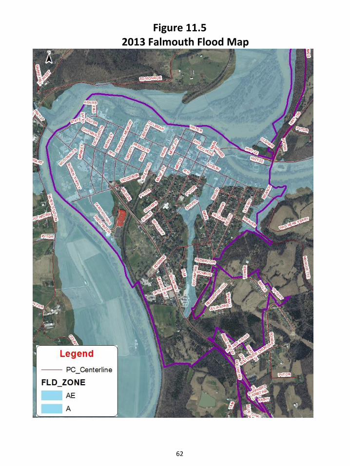
62
Figure 11.5 2013 Falmouth Flood Map

63
Figure 11.6 2013 Pendleton County Flood Map

64
Overview This section is intended to be a tool for the management of growth and development in Pendleton County.
Planned growth is essential to achieving this balance (between maintaining traditions and embracing progress), through the appropriate distribution of land uses ranging from residential to commercial to downtown to agricultural and by instilling quality in new developments.
The recommendations of this section are guided by the Goals and Objectives of this plan, which advocate the efficient use of land resources, timely and efficient infrastructure and public facilities improvements, and protection and enhancement of the natural and social environment. NOTE: This section should be considered as a guide to the appropriateness of proposed land uses throughout the county.
The purpose of this chapter is to determine the GENERAL future land use needs of Pendleton County and the cities of Falmouth and Butler and to designate those areas that are most appropriate for development or preservation. The future land use needs are projected by examining the existing land use patterns, natural features, development opportunities and constraints, infrastructure and public services, and the population trends and projections for Pendleton County as a whole. Economic trends also provide a good foundation for determining local future commercial and industrial needs. The proposed land use classifications and their locations have been designed to give meaning to the desires of the community. The thrust of the Goals and Objectives are also realized here.
For example, from these it is realized that a large part of the perceived quality of life and sense of place are tied up in the agricultural and rural landscapes of Pendleton County. Additionally, a stronger harmony with the environment has figured prominently in the desires of the community. Accordingly, this Plan recommends the preservation and protection of environmentally sensitive areas like flood plains, wetlands, wildlife habitat, and steep wooded slopes. These actions will not only ensure a continuance of a high quality of life and the improvement of safety but can also become one of the County’s prime economic development strategies. Heritage and recreational tourism are increasing in popularity. Pendleton County is in a great position to leverage its unique natural and built environment to attract visitors from around the region and beyond. The Land Use recommendations of this plan can strengthen the attributes of the County and provide a springboard to a thriving economy. The areas recommended for urban development land use classifications are appropriately sited. They are close to roads, water lines, and have present or future sewer availability. Growth can be expected in Pendleton County over the next few years. Much of this growth is projected to be primarily residential as people seek to move into the county in search of affordable housing and more rural lifestyles. (See Table 3.3)

65
When discussing housing future residents, it is important to remember the components of the County’s future population. Both the young and elderly populations are expected to increase. (See Figure 3.3) These populations have similar needs when designing new residential developments – the need for connectivity to commercial, social and public land uses, and parks and recreation facilities. Encouraging quality developments will help meet these needs. The urban development areas identified by this plan can both help accomplish the community's vision of a variety of housing types and prices while at the same time encouraging these quality developments. New commercial areas could stimulate economic expansion and encourage residents to shop within Pendleton County. While no industrial expansion is projected at thistime, it will be important for the community to monitor availability to suit existing and potential businesses. Pursuing the path outlined in this Section is the best way to ensure the community goes where it desires. A failure to act in these ways will only ensure a continual degrading of the values the community treasures.
Cluster Development Agricultural Land Use Pendleton County should be a community rooted in traditional values while maintaining a progressive outlook toward the future. The small town and rural character of the community should be maintained, even in the face of change, which is not only vital to the quality of life of current residents, but will also attract tourists and outside investment.
The foundation of each of these lies in the soil of the County. Agriculture has been, and should continue to be part of the County’s economic base. This plan recognizes this by showing a majority of the County as “Agricultural/ Rural Residential” on the Future Land Use Map.
This Plan also acknowledges that there should be balance between protection for the best interests of the community as a whole and an understanding of private property interests. There is a concern in Pendleton County regarding the need to protect the right of the farmer to carry on agricultural activities with a minimum amount of regulation and a minimum amount of impact from urban-type development, combined with a strongly held view point that many land use alternatives, including residential, should be preserved to the property owner.
To address the balance of these interests, the use of “clustered” low density residential development will be considered for these lands in order to recognize the economic potential for property owners. These residential clusters will be located on portions of properties least suited for agriculture and most easily buffered from agriculturalactivities as well as roadways. The density calculation in these clusters will strive to preserve at least half of the property as open space. For example, a density of one unit per acre on a 100 acre farm produces 100-one acre lots, with no open space or agricultural preservation area.

66
By clustering the allowed number of units, in this case 100, on smaller lots, land for preservation and open space is protected. So for example, by clustering 100 residential units on one-half acre lots, the resulting development occupies 50 acres and preserves 50 acres. Sanitary sewage disposal is a critical concern on these smaller lots and innovative methods beyond on-site septic systems, such as community systems utilizing advanced septic technology - must be employed.
Other concerns such as fencing and buffering, lot dimensions and road standards should be addressed through the County’s Subdivision Regulations.
Environmentally Sensitive Areas
A respect for the environment will ensure a high and healthy quality of life for residents and will help demonstrate the values of the community to the larger region.
The Licking River, long seen as a detriment to the community, should now be managed as one of the community’s greatest assets.
These environmental assets are an indispensable part of the community’s recreational and tourism planning. This Plan defines environmentally sensitive areas as flood- plains, steep slopes, wetlands, and identified areas of endangered or unique animal habitat. No development should be allowed within these areas. In order to protect property rights, the overall density of a property containing such areas should be calculated, then that density should be allowed to be transferred to another portion of the property. While such areas have not been identified on the Future Land Use Map, they should be identified with development applications.
Urban development Urban development is defined as any commercial, non-mineral related industrial, or public use such as a school or library, as well as any residential use at a density of greater than one unit to the acre. These “urban” uses require urban services, such as city water, sanitary sewage disposal, and appropriate roads. Therefore, all urban uses should be planned for connectivity to these urban services. At some point, more extensive urban uses might be appropriate in the sewer shed of a proposed regional sewage treatment plant to be located in the northern part of the County.
Land Use Categories Residential Land Use Due to its proximity to one of the U.S.A.’s largest metropolitan areas, its affordable housing prices, and rural/small town atmosphere, Pendleton County is beginning to feel large scale residential growth pressures. This growth is becoming most evident in the northern portion of the county, as well as on some rural roads throughout the county. Given the nature of the physical constraints in Pendleton County – little flat land outside of dangerous floodplains and many steep slopes – residential pressures will be focused on just a few

67
areas. The existing cities of Falmouth and Butler are obviously two places to be impacted by increased growth. The community should encourage growth in these areas by planning for infrastructure, by supporting redevelopment, and by ensuring that services like schools and parks are available. All urban-density residential growth in these cities should be located within the gravity sewer shed of waste water treatment plants to eliminate the need for costly and unreliable sewage pumping stations. (For further information, see pages 69-70.)
Urban development Land Use Categories The other main area potentially suitable for urban residential growth is found in the northern part of the County for the following reasons:
• less prime/productive farmland would be lost to development; • the location is closer to commercial and job centers, creating less cross- county traffic demand; • sanitary sewage service could be provided by a regional treatment plant on the Grassy Creek; • urban development would not infringe on prime scenic resources; • the topography and land cover provide an ability to create handsome, environmentally sensitive developments.
As attractive as this area is for urban development there are many short comings as well. Much infrastructure and environmental planning would need to occur to ensure that roads are adequate, sanitary sewage service is available, water service is adequate for urban uses, and that environmentally sensitive lands are identified and protected. Due to these limitations, therefore, no urban expansion is planned for this area at this time. When, or if, urban development becomes appropriate in this area, the following standards are proposed for urban development in this area:
• located on “adequate” (a minimum of two travel lanes and shoulders) existing roads, or have the ability to connect new streets to existing “adequate” roads; • water service suitable for fire protection; • be within the sewer shed of, and connected to, a newsewer plant located in the Northern Part of the County; • located away from steep slopes, wetlands, and floodplains; • and be appropriately buffered from existing mining operations.
Due to the potential detrimental impact on roads, water infrastructure, and the environment, urban residential development (greater than one unit per acre) should not occur in this area until and unless these standards can be satisfied.

68
Commercial Land Use Commercial growth in Pendleton County poses a dilemma to many people. While it would be good to capture more retail spending within the county, the primary way to do it currently is to accommodate low cost, large scale retailing. This accommodation could have the unforeseen effect of changing the character of the county visually as well as in a social sense as small retailers would likely suffer. In order to create a balance, new lands for large scale, auto-oriented development should be planned in appropriate places – “Nodes” - along U.S. 27 such as near the Middle School and just north of Butler. While no definitive location for these uses has been shown on the map, the general areas of these are deemed best for the following reasons:
• best highway access in the County; • location near to much of the County’s potential growth; • location near the potential east-west connector route; • not on prime or productive farmlands; • potential availability of urban services of water and sewer; • and less threat of flooding.
These larger scale commercial centers should be planned with an eye for design standards that would prescribe building appearance, signage, maximum parking requirements, highway access, storm water drainage and landscaping. National chains are used to such requirements in other places and would not have any trouble meeting them in Pendleton County. These areas should be developed as “nodes” that include residential, office, and park land within them. Some very light commercial (< 5,000 square feet) may be appropriate in rural areas as “general stores” and in proposed “Hamlet Communities.”
Falmouth Land Use As the economic center and county seat for Pendleton County, it is vital that Falmouth grow efficiently while retaining its uniqueness. Current land use patterns consist of three primary components: the downtown “core,” residential areas, and general commercial “strip” development along U.S. 27. Little room exists within the current city boundaries for new growth. Thus, any significant new development within the city would have to occur on lands that are annexed into the city limits. This Plan recommends and urban residential expansion to the immediate north and south of Falmouth for the following reasons:
• development in these areas would be contained within the sewer shed of the Falmouth Waste Water Treatment Plant; • The lands for the most part lie well above the floodplain of the Licking River; • There is little prime or productive farmland in these areas.

69
As noted earlier in this Chapter, Falmouth accounts for approximately 14% of the County’s current population. For this proportion to continue, Falmouth could expect to see as many as 200 new housing units over the next 20 years. If each of these were constructed on a “typical” one-quarter acre lot, then approximately 50 acres would be needed to be annexed. Less land would be needed if the housing density was higher. Since this Plan anticipates a significant commercial node along U.S. 27 south of Butler, significant commercial expansion beyond the current Falmouth city limits is not recommended at this time. Instead, existing retail areas in Falmouth should be eyed for “makeovers,” intensive rehabilitation and refurbishment of commercial properties. The purpose of these makeovers would be to improve the functionality of Falmouth’s main “strip” with regard to traffic and safety, to improve profitability by adding new land uses as well as increasing size, and to improve the appearance and thus the character of the area. Downtown Falmouth should be promoted to entice people who seek specialized goods, personal service, and a “real experience.” While creating these are absolutely vital for success, it is also important for local merchants to operate on a more standardized economic model with coordinated advertising, common opening hours and mutually supporting organizations. Falmouth has seen a decrease in property values and an increase in flood insurance rates in the areas located within the 1% Special flood Hazard Area. This area of the city also has an aging infrastructure. The combination of the lower property values, increased flood insurance rates, and an aging infrastructure makes this area less valuable for future development. New Urban Development is recommended in an area along US 27 with access to utilities and not within the SFHA. Downtown Falmouth is located within the SFHA, as well. Downtown should be promoted as stated above; however, new urban development should occur in a flood sustainable manner.
Butler Land Use As the northern area of the county is anticipated to be the primary focus for most of the growth over the life of this Plan, the city of Butler can be seen in an advantageous position. This growth will create the need for an identity, which Butler’s quaint downtown can help provide. As with Falmouth, Butler’s downtown could be promoted to entice people who seek specialized goods, personal service, and a “real experience.” Further, the area designated along U.S. 27 for commercial growth could become a hub for the entire northern portion of the county. This would give the current residents of Butler and its surroundings the ability to help shape the character of this area.
Housing growth within Butler proper is not expected to be significant, given that most of the current city limits are built-out. Thus annexation would be needed to add new development within the city. For Butler to keep its current proportion of residents to the overall county as a whole (4.25%), then approximately an additional 50-60 dwelling units would need to be added to the city over the next 20 years. If each of these were constructed on a “typical”one-quarter acre lot, then no more than approximately 15 acres would be needed to be annexed. Less land would be needed if the housing density was higher.

70
Consideration of annexing more residential land than this should encourage a discussion of the benefits and drawbacks to the city of Butler of providing that land with appropriate services.
Industrial Land Use Having enough physical capacity for increased Industrial development is critical to economic and job growth in Pendleton County. The County must decide the appropriate type of industrial activity that best suits it. For example, a desire to accommodate heavy industry that which creates light, smoke, smells, noise, or vibrations may be deemed appropriate. But finding a suitable location for that type of industry in Pendleton County may be difficult. The increased demand for residential growth coupled with the very limited areas in which it may be accommodated may lead to conflicts with this type of industry. Thus it may be that the County would wish to pursue a strategy of seeking light industry. Light industry is defined as a business that has no noticeable effects off the premises of the use. Because of this, light industry uses are generally more compatible with other land uses. However, light industry still creates traffic flow, may have large parking areas, include signage and night lighting and could generate truck traffic. Generally, these uses are best placed in industrial “parks.” Growth of the existing parks in Pendleton County should be encouraged before any new industrial land is designated. The Butler Industrial Park should be included in the sewer shed of the proposed regional sewer plant in the northern portion of the County. The Commonwealth Commerce Center in Falmouth has full utilities and excellent transportation access. Also, natural gas is available via a nearby gas transmission line. It has been designated as the principal industrial development site in the Falmouth vicinity. Mineral related industrial uses are tied directly to the land and as such cannot be shifted into these parks. Current mining activities must be supported, but the community should seriously consider whether to allow new mining activities on previously un-mined land to locate or expand in the County.
Office Land Use As Pendleton County seeks to increase its job base, it may consider adding lands available for office use. The service or “white collar”sector is growing the fastest in the 21st century. These types of jobs are primarily located in office environments and generally these environments are grouped together, creating a critical mass. While it may be premature to designate large areas of the County for office use, considering the possibility is important when reviewing large scale commercial and residential developments. Office uses can be combined with these development types to create employment opportunities close to residents as well as to attract workers to commute into the county.
Public Land Use Public land uses in Pendleton County include the schools, County Courthouse, Falmouth City Hall, Pendleton County Library, Post Office, the wastewater treatment facilities in Butler and Falmouth, Kincaid Lake State Park, and several small recreational spaces. Generally, public land uses may be

71
located anywhere (critical facilities should be located outside of floodplains and historic and culturally sensitive areas) and thus this plan makes no specific recommendations as to locations.
Achieving the Vision The unincorporated county and City of Falmouth zoning ordinances help implement the Vision as well as the Goals and Objectives of this plan. The ordinances are solid, easy to understand and even handedly apply. The primary purpose of the zoning ordinances are to protect existing primary uses in the County, such as agricultural and residential ,while controlling or excluding noxious or undesirable uses. Other purposes of these regulations are to accomplish a number of specific objectives including: conserving the value of buildings and land; facilitating the provision of transportation, water systems, sewage treatment, schools and parks; lessening traffic congestion; preventing overcrowding; providing adequate light and air; and containing damage from fires, floods, and other dangers.
The Future Land Use Map shows four basic land use types, which could be converted into zoning districts: agricultural/rural residential, urban residential, commercial, and industrial. A zoning ordinance could recognize these land use types to encourage their proper development. For example, in a proposed Agriculture/Rural Residential zone – which would encompass the vast majority of the County - all types of farming and farm operations would be permitted, as well as residential development and churches, and perhaps even certain professional office uses as conditional uses. The purpose of this zone would be more to exclude incompatible uses than to regulate residential or agricultural uses. The incompatible land uses that could be excluded, discouraged, or regulated could include such things as drug treatment centers, adult-oriented business, or heavy industry. This protection against unsuitable land uses would hold true for the other zones as well. Specific land development issues regarding lot sizes, setbacks, signage, and landscaping are addressed with a zoning ordinance.

72
Section 12: Community Facilities Plan
IMPORTANCE OF COMMUNITY FACILITIES Much of the quality of life and standard of living for residents in Pendleton County is dependent upon the facilities and public services available to them. These facilities and services support the economic and social fabric of the community and include schools, libraries, parks, municipal buildings, public safety facilities, and sanitation facilities such as water and sewer systems. Public facilities, especially school systems, play an important role in attracting new residents and industries as well as retaining present residents and employers. The age and efficiency of the existing public facilities affect the revenue needs of the cities and county. The efficient layout and construction of new facilities determines the direction for future growth of residential, commercial, and industrial development. For all of the above reasons, it is important that the development of public facilities be coordinated according to the needs and desires of Pendleton County residents and elected officials for their future.
The following are some of the general issues and recommendations regarding local community facilities. Since most of the providers of community facilities have their own detailed plans, it is simply the intention of this plan to bring the various issues to the forefront to provide the Planning Commission a guide to decision making. The complex interrelationship of all of the various infrastructure needs and public services with current and future land use demands that those in positions to make land use decisions consider all of these issues in their decision making process as well aspurely land use compatibility issues. This Plan Update recognizes the fact that growth does have an impact on existing community facilities and encourages the governing bodies to investigate methods to fairly fund public facilities or infrastructure improvements.
Water Service Continued cooperation between the four providers of water service is essential. Each provider should study this plan to see how growth will affectits service area and make future service plans accordingly. It is important to note that installing water lines encourages residential growth, primarily along rural roads. Therefore, if plans are made only to serve existing populations with water service that service is likely to be over-taxed in a short amount of time. It is best to properly size improvements to meet projected needs. Planning for rehabilitation improvements to Falmouth’s water treatment plant should begin now. While the facility has excess capacity, according to the City WWTP/Water Director it is an “aging facility” and will have extensive rehabilitation needs in the future. The City of Falmouth will need to replace waterlines in the near future. The City is currently studying a solution. The City of Butler has recently upgraded waterlines using a community development block grant.

73
Sanitary Sewage Service The City of Falmouth Sewer District has a new treatment plant (opened in 2008) that treats about 500,000 gallons per day and then discharges it into the Licking River. The system operates at about 60+% capacity. The City of Butler Water and Sewer operates two package facilities for treating wastewater. The two facilities can treat a total of 140,000 gallons per day. After treatment, the City discharges it into the Licking River. Currently the plants treat approximately 40,000-50,000 gallons per day, leaving an excess of 90,000 gallons per day. The City of Butler has recently upgraded its sewer lines. The City of Falmouth will need to upgrade sewer lines in the older sections within the next five years.
Future Sanitary Sewage Service The Community should put forth great effort into determining the most appropriate location for a new sanitary sewage treatment facility in the northern area of the County. Finding the proper location for this plant is critical, as its location and construction will inevitably spur urban growth in the watershed surrounding it. Outside the urban areas of Falmouth and Butler, homes and businesses are served by private on-site sewage treatment systems. Alternatives to a proliferation of individual on-site private septic systems need to be pursued, particularly in areas where greater density is being encouraged. This Plan Update recommends the consideration of innovative alternative sewage disposal methods. Private package sewer treatment plants should be discouraged. These plants are notorious for being inefficient, often leading to environmental pollution, as well as costly to operate, which often leads to a need for taxpayer subsidy.
Fire Protection Often new water line extensions are not completed with fire hydrants. This conflict sometimes occurs, because the rural water districts are charged with providing potable water for drinking purposes and are not designed to address rural fire protection. This creates conflict between the increased rural growth and lack of adequate fire protection. This Plan Update proposes that the County consider requiring that all new and replacement water lines installed by any supplier be of a consistent and compatible level of construction, capable of accommodating firehydrants, and that hydrants be constructed at locations designated by the county fire department. Fire station locations must also be considered as the County grows. Planning in advance for advantageous locations will save the community money in the long run. Since this Plan anticipates most of the growth of the County to be in the northern portions of the county it would make sense to make this the main priority area. Fire stations can also serve as magnets for growth as their proximity can help reduce homeowner’s insurance premiums, so early selections of appropriate locations can help locate growth in the desired sections of the county.

74
Section 13: Transportation Plan
Overview Except for U.S. 27, inter-region transportation infrastructure within Pendleton County is poor. While U.S. 27 provides for adequate north/south movement, east/west movement is very difficult. Unfortunately, the Kentucky Transportation Cabinet Six-and Twenty-Year plans do not at this time reflect major transportation improvements.
Key Issues As a growing community, Pendleton County faces numerous transportation issues. Among these many issues are: • Access to interstate is critical to further economic development in the county. • Transportation system that can continue to function in the event of a flood or other natural disaster is important to the county. • Pendleton County has geographic barriers which inhibit accessibility to communities beyond the County’s borders. These barriers are expensive to overcome when developing a cohesive regional highway system. • Good connectivity throughout the transportation system is needed, which would promote intermodal transfer between modes of transportation. In many areas, connectivity of the highway system with the rail transit system and pedestrian system is still lacking. • Gaps in the existing pedestrian and bicycle facilities, cause unsafe conditions for walkers and bikers and make intermodal access difficult.
U.S. 27 As the prime north-south link through Pendleton County, the future of U.S. 27 is vitally important. A small portion of the extreme northern end of U.S. 27 is scheduled for the design phase of a future widening. However, there are no current plans to widen the entire length of U.S. 27. It is important for community leaders to continually push for improvements to the road. Planned improvements should include three and five-lane sections and access management.
KY 22 Emphasis on safety improvements should continue.

75
Unscheduled Needs Every community in the Commonwealth has an opportunity to advocate for locally vital transportation needs through their respective Area Development Districts. Local officials from each community comprising the ADD gather on a regular basis to put forth such local recommendations, which are then collected into a regional Unscheduled Needs list. These “Unscheduled Needs” are simply projects that have not been approved for funding in the State’s current Six-year Plan for construction. This list is regularly updated as projects A project’s appearance on the list is imperative. Few transportation improvements are ever funded without first being listed on an adopted Unscheduled Needs list. The following list represents key items representing Pendleton County’s needs, as put forth by County Judge-Executive David Fields during the 2017 Comprehensive Plan Update. The entire list is available at the Pendleton County Judge/Executive Office.
• PENDLETON 06 096 B0027 171. US 27 RECONSTRUCTION FROM LICKING RIVER BRIDGE TO KY 177. • PENDLETON 06 096 B0027 173. US 27 0.800 TRUCK CLIMBING LN. NB NEAR HARRISON\ PENDLETON C\L. • PENDLETON 06 096 C0000 1. NEW 6.000 NEW ROUTE FROM US 27 APPROX. 1.3 MI N OF HARRISON C\L IN PENDLETON CO. TO KY 539 NEAR THE LICKING RIVER NORTH FORK BRIDGE IN BRACKEN CO. PENDLETON 06 096 COOOO 2. NEW 6.000 NEW ROUTE F US 27 NEAR BUTLER TO KY 9 NEAR MT.AUBURN
• PENDLETON 06 096 D0009 1. KY 911.100 AA HIGHWAY MAJOR WIDENING TO 4 LANES FROM KY 11091N BRAC CO. TO 4 LANE SECTION IN CAMPBELL CO. SEE ALTERNATE 3, PRIORITY SECTION 21N SEPTEMBER 20 KY 9 WIDENING STUDY. • PENDLETON 06 096 D0017 1. KY 170.800 RECONSTRUCTION FROM US 27 TO KY 1853 • PENDLETON 06 096 D0017 2. KY 176.400 RECONSTRUCTION FROM KY 1853 TO KY 467 • PENDLETON 06 096 D0017 3. KY 173.100 RECONSTRUCTION FROM KY 467 TO KENTON C\L • PENDLETON 06 096 D0022 4. KY 229000 RECONSTRUCTION FROM KY 159 TO KY 539 IN BRACK CO. PENDLETON 06 096 D0154 1. KY 154 3.300 RECONSTRUCTION FROM KY 10 AT PEACH GROVE TO 8 • PENDLETON 06 096 D015917 5. KY 159 3.900 RECONSTRUCTION FROM KY 22 AT FALMOUTH TO KY N OF KINCAID STATE PARK

76
• PENDLETON 06 096 00159 ‘ 76. KY 159 6.700 RECONSTRUCTION FROM KY 609 N OF KINCAID STATE PARK TO KY 10 AT MT. AUB..JRN
• PENDLETON 06 096 D0159 ’77 . KY 159 2.500 NEW EXTENSION FROM KY 10 TO AA HWY. KY (KY 9)
• PENDLETON 06 096 D0177 2. KY 177 0.100 REPLACE C RR UNDERPASS IN BUTLER. SEE ALTERNATE 5 IN 200 FIELD STUDY
• PROPOSED LIMITED-ACCESS TWO-LANE HWY FROM FALMOUTH
TO WILLIAMSTOWN • PROPOSED CONNECTOR ROAD FROM BUTLER TO AA HWY

77
Reference Materials
A. Pendleton County “Best of Both Worlds” Plan, Landscape Architecture Department, University of Kentucky, 2005 B. February 25, 2006 Steering Committee Charette Materials C. Determining the Feasibility of Expanding the Economy of
Pendleton County Kentucky: A Market Analysis. January 2005 D. Survey materials (2017 Pendleton County Joint Planning Commission Comprehensive Plan
Update) E. Interviews with county leaders, agencies and entrepreneurs.
2017 Comprehensive Plan Update Community Survey Results: A community survey was prepared and distributed to the public for a three month time period of 2016 and 2017. Notices were posted in the paper, distributed in community centers, on the Pendleton County Facebook page, and on the Pendleton County Website. Surveys were distributed to local businesses, agencies, the Pendleton County Website, and government centers for citizens to complete. The results were 292 surveys were completed, approximately 3% of the county’s approximately 9900 registered voters. Some key results were as follows: 45% of responses were residents of Falmouth. The majorities of participants were between the ages 35-65, have lived in Pendleton County for over 20 years, and 90% of the respondents owned their home. Most respondents choose to live in Pendleton County due to the fact their friends and family are here and they like the rural atmosphere. Two of the most important land use issues to the respondents were improving infrastructure and preserving farms. Important needs for the county were economic development, improving existing roads, tourism development. The survey of housing needs shows a majority of those surveyed would like to see more retirement/assisted living facilities. The survey of recreational needs indicate that those surveyed would like to see a movie theater and a larger farmer’s market. Those surveyed feel zoning regulations are important to preserve existing uses such as hillsides and farms. There was also an interest in enacting local residential building codes. The detailed results are available at the Pendleton County Department of Planning & Zoning.