Embed Size (px)
Citation preview

TAKING STOCK Natural Hazards and Federally Assisted Housing
A joint report byThe Public and Affordable Housing Research Corporation &The National Low Income Housing Coalition

T A K I N G S T O C K : N a t u r a l H a z a r d s a n d F e d e r a l l y A s s i s t e d H o u s i n g
3
4
6
Contents
Executive Summary
Introduction
Methodology
Federally Assisted Homes and Natural Hazards 7
7
10
10
11
12
Overall Risk
Tornadoes
Riverine Flooding
Hurricanes
Earthquake
Wildfire 13
Residents of Federally Assisted Housing 14
14Preparedness Among Low-Income Households
Residents of Federally Assisted Homes Vulnerable to Displacement 15
15
16
Households of Color
Older Adult Households
Households with Children 16
Social Vulnerability and Community Resiliency 17
18
19
The Risk of Natural Hazards by Federal Housing
Program Conclusion and Policy Recommendations
Appendix A: Methodology 21

Andrew Aurand, PhD., MSWNLIHC Vice President for Research
Dan Emmanuel, MSWNLIHC Senior Research Analyst
About NLIHCEstablished in 1974 by Cushing N. Dolbeare, the National Low Income Housing Coalition is dedicated solely to achieving socially just public policy that ensures people with the lowest-incomes in the United States have affordable and decent homes. NLIHC educates, organizes, and advocates to ensure decent, affordable housing for everyone.
The National Low Income Housing Coalition1000 Vermont Avenue, NW Suite 500Washington, DC 20005202-662-1530www.nlihc.org
Keely Stater, PhD.PAHRC Director of Research and Industry Intelligence
Kelly McElwain, MPP PAHRC Research Analyst III
Anna Ward PAHRC Research Analyst
About PAHRCThe Public and Affordable Housing Research Corporation (PAHRC) is a non-profit research center dedicated to conducting research that promotes the national conversation about the importance of affordable housing. PAHRC spotlights the impact, outcomes, and value affordable housing brings to the families it serves and to the communities it supports, delivering data and tools that assist researchers, practitioners, and advocates to build an evidence-based case for why affordable housing matters.
Public and Affordable Housing Research Corporation189 Commerce CourtPO Box 189 Cheshire, CT 06410203-272-8220www.pahrc.org
T A K I N G S T O C K : N a t u r a l H a z a r d s a n d F e d e r a l l y A s s i s t e d H o u s i n g

03
Executive Summary
As the costs and frequency of severe weather events climb, fully understanding and planning for their potential impact on affordable housing is critical. Federally assisted rental properties represent roughly five million homes and account for more than 10% of the nation’s rental stock. They provide housing stability to some of our nation’s most marginalized people with the fewest resources, who are often least able to prepare for a disaster and face significant hurdles during recovery.
This report examines the locations of project-based federally assisted properties in relation to the Federal Emergency Management Agency’s National Risk Index (NRI). The NRI compares across locations the risk of harm from 18 different types of weather, geological, and climate events. Using this measure and other data about the frequency and risk of natural hazards, we find that:
• Nearly one-third of the federally assisted housing stock is in areas with very high or relatively high risk ofnegative impacts from natural hazards compared to one-quarter of all renter occupied homes and14% of owner occupied homes.
• Federally assisted households are less likely than their low-income unassisted peers to have thesupplies and resources needed to adequately to evacuate or prepare to weather a natural hazard.
• Households of color in HUD-assisted housing are more likely than white HUD-assisted householdsto live in areas with greater risk. The Public Housing program has the largest share of units (40%) in areasof very high or relatively high risk of natural hazards.
• USDA programs have the smallest share of units (7%) in areas with very high or relatively high riskof natural hazards.
• Tornadoes pose the largest risk to the federally assisted housing stock among the natural hazardsstudied in this report, though there could be increasing risk from hurricanes and flooding as theseevents intensify.
Natural hazards pose a significant threat to federally assisted housing, while its residents are especially vulnerable to adverse impacts. We encourage federal, state, and local stakeholders to assess the vulnerability of the federally assisted housing in their communities and improve strategies and resources for equitable planning, mitigation, and recovery. The Reforming Disaster Recovery Act and the Disaster Learning and Life Saving Act, two bills under consideration in Congress, provide direction an resources towards this goal.

04
Introduction
The U.S. has seen a significant increase in the frequency and intensity of weather and climate-related events, such as fires, hurricanes, and flooding, as well as a surge in the damages incurred from them.1 The impacts of these events have cost more than $1.9 trillion (in 2021 dollars) since 1980. Over the last decade, the U.S. has experienced at least ten disasters per year whose overall costs have exceeded $1 billion each.2 Disasters place a significant burden on households with low incomes, who are more likely to live in older homes more vulnerable to disaster and who often lack the resources to evacuate in the face of danger or find similar quality housing in the aftermath of loss.3 Residents of federally assisted rental housing may be particularly vulnerable to disasters.
Research suggests rental housing can experience greater damage and recover more slowly from disasters than owner-occupied housing.4 Multifamily and duplex structures are typically slower to recover than single-family structures.5 Multifamily properties may sustain more damage and be more costly to repair when exposed to a natural hazard due to the scale of the physical building and its related systems. Additionally, renters and landlords might not have the same incentives as homeowners to make long-term investments in mitigation features.6 Rental housing is also less likely to benefit from recovery resources.7 Landlords are not eligible for Federal Emergency Management Agency (FEMA) repair assistance, and Community Development
Block Grant – Disaster Recovery (CDBG-DR) funds have historically been disproportionately allocated to programs serving homeowners.8
Lower-cost rental housing is likely at even greater risk of damage and negative recovery outcomes because it is more often characterized by lower physical quality and located in less desirable and more risk-prone areas.9 Many lower-cost rental units, including those that are federally assisted, are older, making them more susceptible to damage due to wear, a lack of upgraded building materials, and older systems than those found or required in newer properties.10
Owners of lower-cost rental properties may find it especially challenging to repair or rebuild their housing due to limited rental income to pay for repairs and meet newer mitigation standards.11 These owners may need to raise rents or sell to new owners with sufficient capital, jeopardizing affordability. In weaker markets where they cannot raise rents, landlords may be harder pressed to rehabilitate their housing at all. Owners of federally assisted rental housing may face an even greater challenge to generate funds to repair or rebuild after a disaster, because rent increases are typically restricted. Without further subsidy for recovery, these owners may be unable to rehab or rebuild their housing.

05
Residents of lower-cost rental housing in either the private or subsidized markets face significant risk of displacement. Displaced low-income renters, moreover, are likely to experience higher housing cost burdens than displaced homeowners.12 Low-income renters living in federally assisted housing may face even greater risks for displacement and loss of affordability. Research on Hurricane Katrina suggests that subsidized renters are least likely to return to their pre-disaster home compared to low-income homeowners or low-income market-rate renters.13 Given that federally assisted units account for approximately 10% of the U.S. rental housing stock and its residents are at significant risk for permanent displacement and financial hardship, it is important to understand how much of the federally assisted housing stock may be vulnerable to natural hazards.14
This report estimates the potential for natural hazards to negatively impact the federally assisted rental housing stock. Natural hazards are severe weather, geological events, and other environmental occurrences that pose a risk to people and property. Not all natural hazards result in disasters with costly or catastrophic outcomes, yet they represent a risk and can also result in negative impacts on a smaller scale. The potential exposure of federally assisted housing to natural hazards is of interest given its inherent vulnerabilities and social value.
The report is divided into six sections. The next section describes the methodology for this report. The third section estimates the number of federally assisted properties at risk of natural hazards. The fourth section explores the risk for people of color, older adults, and people with disabilities served by federally assisted housing. The fifth section examines differences in risk across federal housing programs. The final section provides policy recommendations to mitigate the impact of natural hazards and disasters for federally assisted properties and improve outcomes for residents.
06
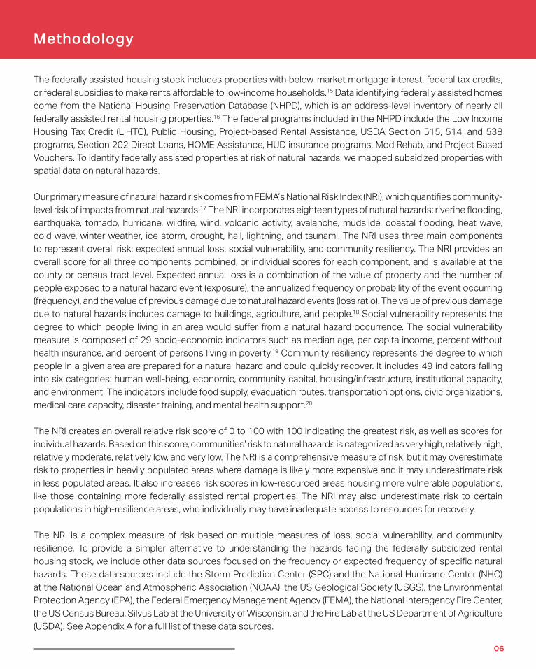
Methodology
The federally assisted housing stock includes properties with below-market mortgage interest, federal tax credits, or federal subsidies to make rents affordable to low-income households.15 Data identifying federally assisted homes come from the National Housing Preservation Database (NHPD), which is an address-level inventory of nearly all federally assisted rental housing properties.16 The federal programs included in the NHPD include the Low Income Housing Tax Credit (LIHTC), Public Housing, Project-based Rental Assistance, USDA Section 515, 514, and 538 programs, Section 202 Direct Loans, HOME Assistance, HUD insurance programs, Mod Rehab, and Project Based Vouchers. To identify federally assisted properties at risk of natural hazards, we mapped subsidized properties with spatial data on natural hazards.
Our primary measure of natural hazard risk comes from FEMA’s National Risk Index (NRI), which quantifies community-level risk of impacts from natural hazards.17 The NRI incorporates eighteen types of natural hazards: riverine flooding, earthquake, tornado, hurricane, wildfire, wind, volcanic activity, avalanche, mudslide, coastal flooding, heat wave, cold wave, winter weather, ice storm, drought, hail, lightning, and tsunami. The NRI uses three main components to represent overall risk: expected annual loss, social vulnerability, and community resiliency. The NRI provides an overall score for all three components combined, or individual scores for each component, and is available at the county or census tract level. Expected annual loss is a combination of the value of property and the number of people exposed to a natural hazard event (exposure), the annualized frequency or probability of the event occurring (frequency), and the value of previous damage due to natural hazard events (loss ratio). The value of previous damage due to natural hazards includes damage to buildings, agriculture, and people.18 Social vulnerability represents the degree to which people living in an area would suffer from a natural hazard occurrence. The social vulnerability measure is composed of 29 socio-economic indicators such as median age, per capita income, percent without health insurance, and percent of persons living in poverty.19 Community resiliency represents the degree to which people in a given area are prepared for a natural hazard and could quickly recover. It includes 49 indicators falling into six categories: human well-being, economic, community capital, housing/infrastructure, institutional capacity, and environment. The indicators include food supply, evacuation routes, transportation options, civic organizations, medical care capacity, disaster training, and mental health support.20
The NRI creates an overall relative risk score of 0 to 100 with 100 indicating the greatest risk, as well as scores for individual hazards. Based on this score, communities’ risk to natural hazards is categorized as very high, relatively high, relatively moderate, relatively low, and very low. The NRI is a comprehensive measure of risk, but it may overestimate risk to properties in heavily populated areas where damage is likely more expensive and it may underestimate risk in less populated areas. It also increases risk scores in low-resourced areas housing more vulnerable populations, like those containing more federally assisted rental properties. The NRI may also underestimate risk to certain populations in high-resilience areas, who individually may have inadequate access to resources for recovery.
The NRI is a complex measure of risk based on multiple measures of loss, social vulnerability, and community resilience. To provide a simpler alternative to understanding the hazards facing the federally subsidized rental housing stock, we include other data sources focused on the frequency or expected frequency of specific natural hazards. These data sources include the Storm Prediction Center (SPC) and the National Hurricane Center (NHC) at the National Ocean and Atmospheric Association (NOAA), the US Geological Society (USGS), the Environmental Protection Agency (EPA), the Federal Emergency Management Agency (FEMA), the National Interagency Fire Center, the US Census Bureau, Silvus Lab at the University of Wisconsin, and the Fire Lab at the US Department of Agriculture (USDA). See Appendix A for a full list of these data sources.

07
Taki
ng S
tock
— N
atur
al H
azar
ds a
nd F
eder
ally
Ass
iste
d H
ousi
ng
Federally Assisted Homes and Natural HazardsThis section estimates the risk of natural hazards to federally assisted rental homes based on the properties’ census tract NRI ratings. We consider the overall risks to the federally assisted rental housing portfolio and then discuss the risk of the more costly natural hazards: tornadoes, flooding, hurricanes, earthquakes, and wildfires. Interactive maps depicting federally assisted housing properties and the risk of these hazards can be found here.
Overall RiskMore than 1.5 million federally assisted housing units, or 32% of the assisted stock, are at very high or relatively high risk of a negative impact from natural hazards. When we include only expected annual loss in the measure of risk (excluding the NRI’s community resiliency and social vulnerability components), one-quarter of federally assisted units are in census tracts with very high or relatively high risk of loss of property and life.
Table: Federally Assisted Homes, Renter Occupied Homes, and Owner Occupied Homes by Overall National Risk Index (NRI) Rating of Census Tract
Assisted Rental Homes Renter Occupied Homes Owner Occupied Homes
NRI (Overall) Risk Rating Number Percent Number Percent Number Percent
Very High 533,521 11% 3,380,542 8% 2,689,173 3%
Relatively High 1,047,797 21% 8,117,791 19% 8,686,907 11%
Relatively Moderate 1,285,185 26% 10,964,893 25% 15,339,237 20%
Relatively Low 1,309,190 26% 11,343,362 26% 22,057,158 29%
Very Low 803,639 16% 9,662,475 22% 28,471,696 37%
Data Unavailable 868 0% 12,604 0% 30,210 0%PAHRC & NLIHC tabulation of NHPD, retrieved 2020, and American Community Survey 2015-2019 (five-year estimates), matched to the National Risk Index (2020).
Federally assisted units are more likely to be located in areas of very high or relatively high risk of a negative impact from natural hazards than renter occupied units and have a similar risk of monetary loss. Twenty-seven percent of renter occupied units are located in census tracts rated as having a very high or relatively high overall risk and 24% are located in areas rated as having a very high or relatively high risk of annual monetary loss. In contrast, just 14% of owner occu-pied units are located in very high or relatively high areas of overall risk and 17% are located in areas with a very high or relatively high annual expected loss risk. Renter occupied units, including federally subsidized units, are likely located in more densely populated and commercial areas that would have greater potential losses from natural hazard damage leading to a higher risk of annual expected
loss. Federally assisted units serve more vulnerable populations, which factor into the socio-economic indicators em-bedded in the NRI, potentially contributing to a higher overall risk of negative impacts from natural hazards in areas where these properties are sited.

08
Taki
ng S
tock
— N
atur
al H
azar
ds a
nd F
eder
ally
Ass
iste
d H
ousi
ng
Table: Federally Assisted Homes, Renter Occupied Homes, and Owner Occupied Homes by NRI Overall Expected Annual Loss of Census Tract
Assisted Rental Homes Renter Occupied Homes Owner Occupied Homes
NRI Overall Expected Annual Loss Number Percent Number Percent Number Percent
Very High 281,812 6% 2,711,830 6% 2,793,240 4%
Relatively High 940,920 19% 7,954,499 18% 9,673,030 13%
Relatively Moderate 1,359,615 27% 11,278,944 26% 16,055,834 21%
Relatively Low 1,398,388 28% 11,195,342 26% 21,353,034 28%
Very Low 999,418 20% 10,329,122 24% 27,370,495 35%
Data Unavailable 47 0% 11,930 0% 28,748 0%PAHRC & NLIHC tabulation of NHPD, retrieved 2020, and American Community Survey 2015-2019 (five-year estimates), matched to the National Risk Index (2020).
Ten states, including California, Florida, Georgia, Illinois, Missouri, New York, New Jersey, Pennsylvania, Ohio, and Tex-as, have more than 50,000 federally assisted rental units in census tracts very high or with elatively high risk ratings.
Map: The Number of Federally Assisted Rental Homes with Very High or Relatively High Risk of Negative Impacts from Natural Hazards (All Hazards) by State
PAHRC & NLIHC tabulation of NHPD, retrieved 2020, matched to the National Risk Index (2020).
MD
MA
OR
CA
NV
ID
MT
WY
UT
AZ
CO
NM
TX
OK
KS
NE
SD
NDMN
IA
MO
AR
LA
WIMI
IL IN OH
KY
TN
MSAL GA
SC
NC
WVDC
PA
DE NJCT
RI
VT
NH
ME
WA
VA
FL
NYNY
AK
HI

09
Taki
ng S
tock
— N
atur
al H
azar
ds a
nd F
eder
ally
Ass
iste
d H
ousi
ng
While fewer in absolute numbers, states in the Midwest tend to have the largest share of their federally assisted portfolios at risk from natural hazards likely due to the widespread risk of tornadoes. States in the west and New England tend to have the lowest shares of their federally assisted housing stock at risk.
Map: The Percent of Federally Assisted Homes by State with Very High or Relatively High Risk of Negative Impacts from Natural Hazards (All Hazards)
PAHRC & NLIHC tabulation of NHPD, retrieved 2020, matched to the National Risk Index (2020).
Most federally assisted housing units face very high or relatively high risk for at least one natural hazard. Eighty-five percent of federally assisted units are in census tracts at high risk for at least one of the 18 natural hazards included in the NRI. The most common threats to federally assisted rental units include tornadoes, strong wind, lightning, winter weather, and heatwaves.
Table: Top Five Natural Hazards (NRI) Impacting Federally Assisted Homes.
Assisted rental homes in census tracts with relatively high or very high hazard risk ratings
Hazard Type Number Percent
Any natural hazard 4,218,571 85%
Tornado 1,796,732 36%
Strong wind 1,517,290 30%
Lightning 1,371,697 28%
Winter weather 1,247,513 25%
Heatwave 1,198,061 24% PAHRC & NLIHC tabulation of NHPD, retrieved 2020, matched to the National Risk Index (2020).
MD
MA
OR
CA
NV
ID
MT
WY
UT
AZ
CO
NM
TX
OK
KS
NE
SD
NDMN
IA
MO
AR
LA
WIMI
IL IN OH
KY
TN
MSAL GA
SC
NC
WVDC
PA
DE NJCT
RI
VT
NH
ME
WA
VA
FL
NY
AK
HI

10
Taki
ng S
tock
— N
atur
al H
azar
ds a
nd F
eder
ally
Ass
iste
d H
ousi
ng
TornadoesTornadoes represent a growing risk to federally assisted housing as the traditional ‘tornado alley’ shifts east towards larger population centers and the average number of storms occurring on a given day increases.21 Tornadoes can raze buildings or leave them uninhabitable due to damage to the structure or building systems like heating, plumb-ing, and electrical power. Thirty-six percent of federally assisted units are located in census tracts with very high or relatively high tornado hazard risk.
According to NOAA data on the frequency of past tornadoes, 37% of federally assisted units (1.8 million) were locat-ed within 25 miles of a tornado’s path (any intensity) at least once per year, on average, over the last 30 years. Many more federally subsidized housing units have been near the path of past tornadoes whose wind speeds can cause considerable damage, though not with such frequency. More than half of federally assisted units (2.5 million) are within 25 miles of the path of at least three tornadoes capable of considerable damage (EF2+) since 1990.22
Table: Federally Assisted Rental Homes’ Risk and Previous Exposure to Tornadoes
Sited in location that has… Number of Units Percent of Units
Very high or relatively high tornado hazard risk rating (NRI) 1,796,732 36%
Experienced 1 tornado (EF0+) per year, on average, since 1990 1,828,923 37%
Experienced 1 tornado capable of considerable damage (EF2+) per decade since 1990
2,518,788 51%
PAHRC & NLIHC tabulation of NHPD, retrieved 2020, matched to NOAA: SVRGIS Severe Weather Report 1990-2019 and the National Risk Index (2020). Excludes proper-ties located in Alaska and Hawaii.
While the number of properties directly impacted by tornadoes in a given year may be small, the fact that over one-third of federally assisted homes are in areas with a high frequency of tornadoes suggests housing providers and policymakers should review their level of preparedness, current mitigation practices, and recovery resources for homes at risk of tornadoes.
Riverine FloodingFlooding of waterways and low-lying areas can cause significant property damage and tenant displacement. One inch of flooding can cause $26,000 in damage and lead to mold or other health concerns.23 Sixteen percent of federally assisted housing units are in census tracts with very high or relatively high risk of negative conse-quences from riverine flooding.
FEMA’s National Flood Hazard Layer (NFHL) indicates fewer federally assisted rental homes at risk of a major flood than the NRI. FEMA cre-ated the NHFL map to assist property-owners in determining flood risk and to support the National

11
Taki
ng S
tock
— N
atur
al H
azar
ds a
nd F
eder
ally
Ass
iste
d H
ousi
ng
Flood Insurance Program, which underwrites property losses not always covered by private insurance in flood-prone areas.24 Yet the NFHL may underestimate the risk of flood. A recent analysis by First Street found that the number of properties at substantial risk of flooding was 1.7 times the number in FEMA’s 100-year flood hazard layer.25 The disparity between the number of federally assisted units at risk using the NRI versus the NFHL suggests that a more in-depth consideration of flood risk beyond the NFHL may be needed when siting subsidized housing properties or recommending flood mitigations for these properties.
Over 200,000 federally assisted rental homes are located within a regulatory floodway or within FEMA’s 100-year flood plain, which identifies areas with a 1% annual chance of a flood. An additional 242,000 federally assisted units, or 5% of the stock, are located in the 500-year flood plain, which are areas with a .2% annual chance of a flood. Nine percent of federally assisted units are in areas of undetermined flood hazard by the NFHL.
Table: Federally Assisted Rental Homes’ Risk and Potential Exposure to Riverine Flooding
Sited in location that is… Number of Units Percent of UnitsVery high or relatively high riverine flooding hazard risk rating (NRI) 821,325 16%
in the 100 year floodplain or a Regulatory Floodway 224,608 5%
in the 500 year floodplain 241,525 5%PAHRC & NLIHC tabulation of NHPD, retrieved 2020, matched to NFHL (2020) and the National Risk Index (2020).
HurricanesHurricanes and tropical storms pose a significant risk to property and can cause long-term displacement of tenants. Annual costs across the residential, commercial, and public sectors due to property damage from hurricane wind, storm surge, and rain is estimated at $54 billion.26 Hurricanes are growing stronger and intensifying more rapidly due to climate change, which puts more of the housing stock at potential risk for severe damage.27 Five percent of feder-ally assisted units are at very high or relatively high risk of a negative impact from hurricane winds based on the NRI.
Yet examining historical storm tracks compiled by NOAA, we find that 10% of federally assisted housing units are within 50 nautical miles of at least one hurricane per decade, on average. Over 100,000 of federally assisted rental units, or 2%, are in areas that are, on average, within 50 nautical miles of at least one category three, four, or five hurricane per decade. Even if the frequency of hurricanes does not increase, more federally assisted rental units will likely face high risk as storms continue to intensify.
Table: Federally Assisted Homes’ with Risk and Previous Exposure to Hurricanes
Sited in location that is… Number of Units Percent of Units
Very high or relatively high hurricane risk rating (NRI) 253,681 5%
Within 50 nautical miles of at least 1 hurricane each decade, on average, since 1990 516,013 10%
Within 50 nautical miles of at least 1 category 3-5 hurricane each decade, on average, since 1990 104,540 2%
PAHRC & NLIHC tabulation of NHPD, retrieved 2020, matched to NOAA International Best Track Archive for Climate Stewardship 1900-2019 historical hurricane tracks (2020) and the National Risk Index (2020).

12
Taki
ng S
tock
— N
atur
al H
azar
ds a
nd F
eder
ally
Ass
iste
d H
ousi
ng
Coastal flooding from storm surges due to tropical storms and hurricanes also puts residents at risk of displacement. The Congressional Budget Office (CBO) estimated residential sector property losses from hurricane and tropical storm-related flooding to be approximately $20 billion per year in 2017 dollars.28 Based on the NRI, 1.5% of federally assisted units are at very high or relatively high risk of negative impacts from coastal flooding, which could increase as sea levels rise due to climate change. The National Housing Trust and Climate Central estimate that three times as many federally assisted and naturally occurring affordable housing units could be at risk of coastal flooding by 2050 due to sea level rise.29 This projection would put nearly 5% of federally assisted units at risk of coastal flooding by 2050.
NOAA’s coastal flooding zones indicate a greater potential risk of coastal flooding for the federally assisted hous-ing stock than the NRI. More than 475,000 federally assisted rental units, or 9%, are at risk of storm surge from a major – category 3, 4, or 5 – hurricane. Nearly 250,000 units, or 5%, are at risk of storm surge during a Category 1 or 2 hurricane. The higher number of units in NOAA’s coastal flooding zones than in NRI high risk areas suggests that many areas in NOAA’s coastal flooding zones may not yet have experienced actual flooding-related losses, which are included in the NRI. This gap may close as development along the coast and the severity of coastal storms both increase.
Table Seven: Federally Assisted Rental Homes’ Risk and Potential Exposure to Coastal Flooding
Sited in location that … Number of Units Percent of Units
At very high or relatively high coastal flood risk rating (NRI) 76,973 1.5%
Could experience coastal flooding in a major (category 3-5) hurricane 470,875 9%
Could experience coastal flooding in a category 1 or 2 hurricane 248,388 5%
PAHRC & NLIHC tabulation of NHPD, retrieved 2020, matched to NOAA National Storm Surge Hazard Maps (2018) and the National Risk Index (2020).
EarthquakeEarthquakes cost $6.1 billion annually in damage to the building stock according to USGS and FEMA.30 According to the NRI, 13% of federally assisted units are located in census tracts with very high or relatively high risk for im-pacts from earthquakes. More generally, we estimate with USGS data units, that 6% of federally assistance units have a 10% chance of experiencing moderate to heavy damage from ground shaking within 50 years. Retrofitting existing properties to mitigate earthquake damage, such as reinforcing structural walls and supports, is critical where applicable.31
Table Eight: Federally Assisted Rental Homes’ Risk and Potential Exposure to Earthquakes
Sited in location that… Number of Units Percent of Units
Has a very high or relatively high earthquake risk rating (NRI) 646,690 13%
Has a 10% chance of experiencing ground motion that could incur moderate to heavy damage over 50 years 307,608 6%
PAHRC & NLIHC tabulation of NHPD, retrieved 2020, matched to USGS National Seismic Hazard Model for the conterminous United States (2018), Alaska Seismic Hazard Model (2007), and the Hawaii Seismic Hazard Model (1998) and the National Risk Index (2020).

13
Taki
ng S
tock
— N
atur
al H
azar
ds a
nd F
eder
ally
Ass
iste
d H
ousi
ng
WildfireThe annual cost of wildfires, including preparedness, suppression, evacuation, and losses can range from $71 billion to $341 billion.32 Only 2% of federally assisted units, however, have a very high or relatively high risk for experiencing a wildfire, accord-ing to the NRI. According to the USGS, less than 1% of federally assisted rental units have been within the perimeter of a wildfire since 2000.
Wildland-Urban Interface (WUI) perimeters represent the spatial relationship between housing density and nearby wildland vege-tation that can sustain wildfires. Fire spreads more easily in areas with plentiful vegeta-tion for fuel and residential development.33 Twenty-two percent of federally assisted housing units are in WUIs associated with a higher-than-average risk of fire, three percent of which are in low-density WUIs, where the space between houses and areas of vegetation for fuel are enough to create an even greater risk of exposure to wildfire.34
Wildfire season duration and damage appear to be increasing due to climate change, previous wildfire suppression policies, and increased development in vegetated areas or WUI’s.35 Moreover, serious droughts exacerbate wildfire risk. An average of 12% of federally assisted units were located in areas experiencing at least six months of moder-ate to exceptional drought annually since 2009, and 7% of units were located in areas with severe to exceptional drought. These trends may indicate more federally assisted housing stock will be at risk for wildfire in the future.
Sited in location that … Number of Units Percent of Units
Has a very high or relatively high wildfire risk rating (NRI) 94,772 2%
Is in the perimeter of a previous wildfire 2,356 .05%
Is in a Wildland-Urban Interface (WUI) 1,087,736 22%
Is in a low-density WUI 70,060 3%
Has experienced a severe to exceptional drought for half the year each year, on average, since 2009 325,992 7%
PAHRC & NLIHC tabulation of NHPD, retrieved 2020, matched Silvus Lab Wildland-Urban Interface (WUI) Change 1990-2010 Data (2018), National Interagency Fire Center: Historical Wildfire Perimeters 2000-2018 (2020), and the National Risk Index (2020).

14
Taki
ng S
tock
— N
atur
al H
azar
ds a
nd F
eder
ally
Ass
iste
d H
ousi
ng
Residents of Federally Assisted HousingRenters living in federally assisted properties tend to have more health and financial challenges than their low-in-come unassisted renter peers.36 Federal assistance programs disproportionately serve people of color, older adults, individuals with disabilities, and families with children.37 Nearly half of householders living in these properties are older adults, living with a disability, or both. Households receiving federal housing assistance also have lower in-comes, on average, than their unassisted low-income peers.38
Preparedness Among Low-Income Households Federally assisted renters may find it more difficult to prepare for or evacuate and recover from a disaster due to their limited financial resources and possible health limitations. The American Housing Survey indicates that federally assisted households are less likely than their low-income unassisted peers to have an adequate supply of bottled water, money to cover a short evacuation, or access to a vehicle for evacuation. Only 30% of low-income federally assisted households report having savings or credit card balances to fund evacuation expenses up to $2,000 com-pared to 48% of low-income unassisted renters. Additionally, only 63% of low-income federally assisted households reported having access to a vehicle to evacuate their family compared to 84% of low-income unassisted renters. They are also less likely than unassisted households to have access to key financial information, a communication plan if phone service is disrupted, an emergency kit, or a predetermined meeting place if household members are separated. With fewer resources for preparedness, federally assisted households are more vulnerable to negative impacts from disasters than their low-income counterparts and other households.
Household has…Low-Income Federally Assisted Renter Households
.Unassisted Low-Income Renter Households
All Unassisted Households, Any Income (renters and homeowners)
3 gallons of water per person 54% 58% 60%***
3 days of non-perishable food 78% 77% 83%***
Access to vital financial information 74% 75% 83%***
Communication plan if cell service disrupted 33% 30% 27%**
Pre-determined meeting location if household members are separated
39% 39% 37%
Access to vehicle 63% 84%*** 94%***
Emergency kit 51% 51% 54%*
Evacuation funds of $2,000 30% 48%*** 81%**
PAHRC tabulation of American Housing Survey 2017. Difference between group and assisted renters is statistically significant: * p=<.05 **p<=.01***p<=.001. Low-income is defined as income below 200% of poverty level. In some high-cost areas, assisted renters may have incomes above 200% of the poverty level.

15
Taki
ng S
tock
— N
atur
al H
azar
ds a
nd F
eder
ally
Ass
iste
d H
ousi
ng
Residents of Federally Assisted Homes Vulnerable to DisplacementEvidence from hurricanes Harvey, Katrina, and An-drew demonstrate that low-income households and people of color are hit the hardest by severe natural hazards and experience higher long-term displacement rates.39 These trends likely arise because investments in preparedness and mitigation strategies are lower in communities of color.40 People of color are more likely to live in older, segregated, and disaster prone areas41, and have less economic, social, and cultural capital to prepare and respond to a disaster.42
Since federally assisted properties dispropor-tionately assist people of color, older adults, and families with children – residents who may have
greater vulnerabilities to disasters – we compare the risk of these households relative to other tenants of federally assisted properties, using the NRI. To do so, we identify households in HUD-assisted housing in which the head is a person of color, an older adult (62+ years of age), or has children living in the household. We included in this analysis Public Housing and Section 202, Section 811, and Project-Based (Section 8) Rental Assistance. Resident characteristic data are not widely available for LIHTC, FHA, USDA, or HOME properties. We find that households of color in HUD-as-sisted housing are more likely than white HUD-assisted households to live in areas with greater risk.
Households of Color
Forty-three percent of HUD-assisted households of color live in areas with very high or relatively high risk of natural hazards, compared to 28% of HUD-assisted white households. Meanwhile, 28% of HUD-assisted households of color live in relatively low or very low risk areas, compared to 46% of white HUD-assisted households. This pattern may be slightly overstated since HUD-assisted properties predominantly serving people of color may be located in more pop-ulated areas, which the NRI weights more heavily for risk. Nonetheless, pre-disaster planning, mitigation strategies, and recovery must include marginalized populations to ensure equitable outcomes.
Table: HUD-assisted Households’ Risk of Natural Hazards (NRI) by Race/Ethnicity
National Risk Index Rating
Head of household is person of color Head of household is white
Households (1.3M) Percent Households (872k) Percent
Very High 217,155 16% 80,387 9%
Relatively High 359,335 27% 164,656 19%
Relatively Moderate 380,070 29% 228,843 26%
Relatively Low 268,229 20% 244,507 28%
Very Low 104,167 8% 153,883 18%
PAHRC & NLIHC tabulation of NHPD, retrieved 2020, matched to the National Risk Index (2020) and Picture of Subsidized Households (2020).

16
Taki
ng S
tock
— N
atur
al H
azar
ds a
nd F
eder
ally
Ass
iste
d H
ousi
ng
Older Adult Households Older adults living in federally assisted housing have lower levels of mobility and more medical conditions than unas-sisted low-income older adult households.43 They may have more difficulty leaving their homes during an evacuation. According to the NRI, 38% of HUD-assisted households with a householder or spouse aged 62 years or older live in census tracts with a very high or relatively high risk of a natural hazard, which is similar to the share of HUD-assist-ed households with younger householders. Nonetheless, pre-disaster planning and disaster response and recovery should consider the location of older HUD-assisted households given their potentially limited ability to respond to a disaster.
Table: HUD-assisted Households’ Risk of Natural Hazards (NRI) by Age
National Risk Index Rating
Head of household or spouse is 62+ years of age
Head of household or Spouse is under 62 years of age
Households (1.0M) Percent Households (1.2M) Percent
Very High 137,997 13% 159,539 14%
Relatively High 252,742 25% 271,227 23%
Relatively Moderate 276,814 27% 332,093 28%
Relatively Low 239,555 23% 273,152 23%
Very Low 123,983 12% 134,087 11%
PAHRC & NLIHC tabulation of NHPD, retrieved 2020, matched to the National Risk Index (2020) and Picture of Subsidized Households (2020).
Households with ChildrenLow-income families with children may have special concerns during evacuation or potential displacement, such as an adequate supply of infant food and diapering materials and temporary housing with adequate sleeping arrange-ments. According to the NRI, 36% of HUD-assisted households with children live in census tracts with a very high or relatively high risk of a natural hazard, compared to 38% of those without children.
Table: HUD-assisted Households’ Risk of Natural Hazards (NRI) by Presence of Children
National Risk Index Rating
With Children Without Children
Households (637k)Households (637k) PercentPercent Households (1.3M)Households (1.3M) PercentPercent
Very High 82,983 13% 182,118 14%
Relatively High 145,975 23% 318,069 24%
Relatively Moderate 181,804 29% 356,969 27%
Relatively Low 151,727 24% 299,205 23%
Very Low 75,289 12% 144,070 11%PAHRC & NLIHC tabulation of NHPD, retrieved 2020, matched to the National Risk Index (2020) and Picture of Subsidized Households (2020).

17
Taki
ng S
tock
— N
atur
al H
azar
ds a
nd F
eder
ally
Ass
iste
d H
ousi
ng
Social Vulnerability and Community Resiliency A community’s ability to respond to and recover from a disaster due to a natural hazard depends on the commu-nity’s resources and capacity of its residents.44 The NRI’s social vulnerability component, which reflects the level of difficulty community residents may face in responding to the negative impacts of a disaster, includes demographic and economic factors like median age of residents, per capita income, poverty rate, percent of female-headed households, and other indicators that represent residents’ capacity to prepare for, respond to, and successfully recover from a disaster.45 Communities with fewer social and economic resources will likely face greater challenges after a disaster. Federally assisted units are more likely to be located in areas of very high or relatively high levels of social vulnerability than rental occupied units in general and owner occupied units. Forty-one percent of the federal-ly assisted housing stock is in census tracts with very high or relatively high levels of social vulnerability compared to 22% of renter occupied units and 13% of owner occupied units.
Table: Federally Assisted Homes, Renter Occupied Homes, and Owner Occupied Homes by Social Vulnerability Index (NRI)
Social Vulnerability Index
Assisted Rental Homes Renter Occupied Homes Owner Occupied Homes
Number Percent Number Percent Number Percent
Very High 211,456 4% 563,489 1% 581,233 1%
Relatively High 1,852,865 37% 9,253,791 21% 9,106,375 12%
Relatively Moderate 1,894,805 38% 16,913,159 39% 26,715,039 35%
Relatively Low 857,505 17% 13,358,788 31% 30,040,153 39%
Very Low 162,701 3% 3,379,836 8% 10,801,371 14%
Data Unavailable 868 0% 12,604 0% 30,210 0%PAHRC & NLIHC tabulation of NHPD, retrieved 2020, American Community Survey 2015-2019 (five-year estimates), matched to the National Risk Index (2020).
The NRI’s community resiliency component, which measures the ability of a community to prepare for and respond to a disaster, includes community factors such as social networks, volunteerism, local food supply, disaster training and experience, and evacuation routes, along with social and economic indicators.46 Forty-two percent of federally
assisted homes are in census tracts with very high or relatively high community resiliency. Federally assisted units are slightly less likely to be located in areas of very low or relatively low levels of community resiliency than renter occupied units in general, but are more likely to be in areas with very or relatively low com-munity resiliency than owner occupied units. Twenty-six percent of the federally assisted housing stock is in census tracts with very low or relatively low levels of community resiliency compared to 28% of all renter occupied units and 21% of owner occupied units.

18
Taki
ng S
tock
— N
atur
al H
azar
ds a
nd F
eder
ally
Ass
iste
d H
ousi
ng
Table: Federally Assisted Homes, Renter Occupied Homes, and Owner Occupied Homes by Community Resiliency Index (NRI)
Community Resiliency Index
Assisted Rental Homes Renter Occupied Homes Owner Occupied Homes
Number Percent Number Percent Number Percent
Very High 653,570 13% 5,177,027 12% 12,087,896 16%
Relatively High 1,461,427 29% 11,635,070 27% 23,651,784 31%
Relatively Moderate 1,593,952 32% 14,363,827 33% 24,726,297 32%
Relatively Low 1,077,391 22% 11,013,524 25% 14,975,775 19%
Very Low 193,813 4% 1,280,289 3% 1,803,881 2%
Data Unavailable 47 0% 11,930 0% 28,748 0%PAHRC & NLIHC tabulation of NHPD, retrieved 2020, American Community Survey 2015-2019 (five-year estimates), matched to the National Risk Index (2020).
Together, the results of the NRI’s Social Vulnerability Index and Community Resiliency Index suggest that a significant portion of federally assisted rental housing is in areas where residents may lack the tools to stave off negative impacts of a disaster, like displacement or income shocks. At the same time, a substantial portion of federally assisted housing units are in communities with infrastructure and community supports to aid recovery. These infrastructure supports must reach and aid the most vulnerable and marginalized populations living in these communities. Local planning and emergency management officials can identify federally assisted housing properties and work with the owners of these properties in advance to ensure that residents receive assistance if a disaster threatens the community.
The Risk of Natural Hazards by Federal Housing ProgramOne-third of the federally assisted housing stock is in census tracts with very high or relatively high risk of negative impacts from natural hazards, according to the NRI. Exposure or potential exposure to natural hazards, however, varies among federal housing programs. Public Housing might be at higher risk due to a history of building it on land not valued by the market.47 Indeed, 40% of Public Housing units are located in very high or relatively high-risk
areas, making it the program with the largest share of its units at risk. Developers utilizing other subsidies, like LIHTC, may also have found it easier to produce affordable rental housing in low-cost areas, potentially more vulnerable to natural hazards or with lower community resilience.48 Yet, thirty percent of LIHTC units are located in very high or relatively high-risk areas compared to 27% of all rental units in the U.S. Some states have attempted to reduce risk by prioritizing LIHTC development in areas with lower natural hazard exposure.49 USDA programs have the lowest share of units located in very high or relatively high risk areas.

19
Taki
ng S
tock
— N
atur
al H
azar
ds a
nd F
eder
ally
Ass
iste
d H
ousi
ng
Table: NRI Risk Rating of Very High or Relatively High by Subsidy Type
Number of Units Percent of Units
Low-income Housing Tax Credit (LIHTC) (2.5M)
Very High/Relatively high 775,784 30%
Project-based Rental Assistance (1.5M)
Very High/ Relatively High 531,277 35%
Public Housing (947k)
Very High/Relatively High 374,278 40%
USDA Housing (435k)
Very High/ Relatively High 31,869 7%
Other HUD-assisted housing (1.6M)
Very High/ Relatively High 510,913 33%PAHRC & NLIHC tabulation of NHPD, retrieved 2020, matched to the National Risk Index (2020).
While units subsidized through USDA programs are less likely located in very high or relatively high risk areas, the NRI may underestimate risks in rural communities. The NRI is weighted by previous losses and vulnerability to loss, so that more populated areas will necessarily score higher on the risk factors incorporated into the index. At the same time, the NRI’s methodology increases risk scores in low-resourced areas housing more vulnerable populations, like those containing more federally assisted rental properties.
Conclusion and Policy RecommendationsOne-third of the federally assisted rental housing stock is located in areas at very high or relatively high risk of natural hazards. This housing, which is the result of major public investments, provides affordable and stable housing to some of the nation’s lowest-income renters and is difficult to replace. We must ensure that this housing supply, and the residents who rely upon it, are protected in the face of growing risks.
The bipartisan Reforming Disaster Recovery Act, a bill introduced and passed in the House of Representatives during the 116th Congress, includes key improvements to federal recovery policy that would benefit federally assisted hous-ing. The Act would permanently authorize the Community Development Block Grant – Disaster Recovery (CDBG-DR) program and make important reforms to achieve more equitable disaster recovery and resilience. CDBG-DR is one of the most important federal resources for infrastructure and housing recovery after disasters. Permanently authoriz-ing the CDBG-DR program will expedite the distribution of funds to impacted communities by requiring HUD to allo-cate CDBG-DR funds within 60 days of approval by Congress. This will help ensure that recovery funds reach federally assisted properties and their residents more quickly and shorten the recovery process.
The Reforming Disaster Recovery Act requires federal recovery dollars to prioritize one-for-one repair or replacement of federally assisted rental housing damaged or destroyed by a disaster, while requiring that the housing rebuilt or substantially repaired using federal recovery dollars in flood-prone areas meets mitigation standards. The Act also requires HUD to release recovery data disaggregated by race, geography, and any classes protected under federal fair housing and civil rights laws. These data will allow community advocates and survivors to hold states accountable for ensuring racial equity during recoveries, including for the residents of federally assisted housing. The Act also requires states to develop plans for compliance with federal fair housing obligations in recovery contexts.

20
Taki
ng S
tock
— N
atur
al H
azar
ds a
nd F
eder
ally
Ass
iste
d H
ousi
ng
The Disaster Learning and Life Saving Act, a bill reintroduced in the current Congress by Senators Brian Schatz (D-HI) and Bill Cassidy (R-LA), would establish an independent National Disaster Safety Board (NDSB) modeled on the National Transportation Safety Board (NTSB). The NDSB would investigate the underlying causes of disaster-related fatalities and property damage after disasters and make evidenced-based recommendations for all levels of govern-ment to improve community resiliency. The NDSB would also include a special office with a focus on mitigating disas-ter impacts for socially vulnerable populations such as people with low incomes, the elderly, people with disabilities, and communities of color.
A thorough assessment of federal housing programs is needed to determine which properties and populations are most at risk and, consequently, which mitigation strategies might be most needed and effective. For example, at the national level, tornadoes pose the greatest risk to the federally assisted housing stock. Additional mitigation strat-egies for wind may need to be reviewed and further incentivized through funding mechanisms for the subsidized housing stock. When it comes to flood mitigation, the federal government has already taken important steps. The Biden Administration’s recent reinstatement of the Federal Flood Risk Mitigation Standard (FFRMS) will help ensure housing constructed through federal funds is located in areas safe from the future effects of climate change-driven sea level rise. The White House, however, should direct HUD to implement these standards quickly.
Federal agencies could also provide more resources to help local housing providers assess their own risks and access the appropriate mitigation resources. At the same time, templates for business continuity planning and other disas-ter planning aids could assist local housing providers prepare for future impacts from natural hazards. Resources for resident preparedness are also critical as assisted renters are less likely to be prepared for a disaster than low-income unassisted renters.
At the state and local level, policy and planning can help preserve federally assisted housing after disasters and mitigate risk. LIHTC, the largest federal rental housing production program, is administered by state housing fi-nance agencies (HFAs). HFAs can use their Qualified Allocation Plans (QAP) to incentivize the development of LIHTC projects in census tracts with lower exposure to natural hazards and encourage robust preparedness efforts, while also prioritizing credits for communities hardest hit by disasters. When scoring proposed housing developments for LIHTC awards, for example, Alabama includes points in their QAP for properties with a storm shelter on site, Arizona prohibits tax credit awards in a 100-year flood plain, and Indiana awards points to projects rehabilitating properties left vacant due to disasters.50
At the local level, housing providers can engage emergency managers to ensure their residents’ needs are consid-ered in pre-disaster planning and mitigation strategies improve disaster resilience for their properties.51 Likewise, emergency managers can reach out to HUD-assisted and USDA housing providers and homeless shelter and service providers to integrate their residents into current local planning processes and ensure mitigation investments benefit vulnerable communities.
Low-income families living in federally assisted housing properties may be the most vulnerable to displacement or financial hardships after disasters. Continuing to enhance our planning, mitigation, and recovery resources for the federally assisted housing stock is critical to helping these families improve their outcomes after disaster.

21
Appendix A: Methodology
Methodology: Assessing Vulnerability to Natural Hazards
Natural Hazard
Methodology
Tornado
Tornado point and path data from 1990 to 2019 was obtained from NOAA’s SVRGIS Severe Weather Report.52 Coordinates of tornado start points between 1990 and 2019 were converted to polylines, if necessary, by adding .0001 to the end lat/long coordinates if they were missing an end point. North America Albers Equal Area Conic was used for the mapping using an equal area projection. A fishnet grid of 80km per grid was created over the contiguous 48 states and storm paths were intersected with the grid and then clipped to the 80km grid cells. Storm paths and the grid layer were spatially joined. The joined data was then extracted to calculate the average number of EF0+, EF2+, and EF4+ tornadoes per time period in each grid cell and any storms passing through a grid repeatedly were de-duplicated. These data were then rejoined to the grid cells.
The EF0+, EF2+, and EF4+ tornadoes per time period in each polygon grid cells were then converted to raster grid cells and were smoothed by applying a low pass 3x3 filter. The smoothed raster was converted to points and IDW interpolation was applied (using a cell size of 80km, Power 2, and a fixed radius 360km) to further smooth the data. Contours following NOAA’s 30-year severe weather climatol-ogy maps were then created from the smoothed raster file53. Contours were clipped to the contiguous US boundaries and the layer re-projected to WGS_1984_Web_Mercator_Auxiliary_Sphere. This layer was then spatially joined to NHPD data with point locations of federally assisted housing properties to estimate the number of properties in grids within 25 miles of various storms. This method applies a modified version of the method described in FEMA Benefit-Cost Analysis Reengineering (BCAR): Tornado Safe Room Module Methodology Report54.
Earthquake
Peak horizontal acceleration (pga) with a 10% probability of exceedance in 50 years (site class D) esti-mates were obtained from the USGS 2018 National Seismic Hazard Model for the conterminous United States55, 2007 Alaska Seismic Hazard Model56, and the 1998 Hawaii Seismic Hazard Model.57 Esti-mates for soil type D (rock) are presented in this report because site class B/C (stiff soil) estimates are not available in Alaska and Hawaii. Earthquake peak ground acceleration values were projected using GSC_WGS_1984 as specified by USGS. This point data was converted to .05 degree raster grid cells and contours following USGS probabilistic seismic hazard maps were created. The raster was then re-projected to WGS_1984_Web_Mercator_Auxiliary_Sphere and reclassified as a polygon feature clipped US contiguous boundaries. AK and HI data were then appended to the polygon. This feature was spatially joined to NHPD property locations. Areas with a 10% chance of experiencing pga values exceeding .34g over 50 years were classified as capable of experiencing an earthquake that could incur moderate to heavy damage,
Riverine Flooding
National Flood Hazard Layer (NFHL) was obtained from Esri’s 2020 USA Flood Hazard Areas map service.58 The polygon features were re-projected to the WGS_1984_Web_Mercator_Auxiliary_Sphere coordinate system. The features were then spatially joined to NHPD property locations.

22
Wildfire
Wildland-Urban Interface (WUI) boundaries for 1990, 2000, and 2010 were obtained through Silvus Lab59, wildfire perimeters from 2000 to 2018 were obtained by the National Interagency Fire Center60, and 2020 wildfire hazard potential index were obtained by the USDA.61 The polygon and raster features were re-projected to the WGS_1984_Web_Mercator_Auxiliary_Sphere coordinate system. The fea-tures were then spatially joined to NHPD property locations.
Hurricanes
Hurricane path data from 1990 to 2019 was obtained from NOAA’s International Best Track Archive for Climate Stewardship62 and coastal storm surge estimates by hurricane intensity were obtained from NOAA’s 2018 National Storm Surge Hazard Maps.63
SVRGIS Severe Weather Report.64 Storm tracks were re-projected to the North America Albers Equal Area Conic coordinate system. 50km grid cells were imported from: https://www.epa.gov/crwu/coast-al-storm-surge-scenarios-water-utilities to follow EPA’s hurricane frequency map and re-projected to the North America Albers Equal Area Conic coordinate system. A 50 nautical mile buffer was applied to each storm track and spatially joined one to many to identify which grid cells each storm intersected. These data were exported and aggregated by grid cell accounting for duplicate storms (the strongest version of each storm within 50 nautical miles of each grid was counted). They were then joined to the grid layer and re-projected to WGS_1984_Web_Mercator_Auxiliary_Sphere to spatially join to NHPD property locations to estimate the number of properties in grids 50 nautical miles from various storms and the storm surge depth by hurricane intensity.
NRINational risk index, expected annual loss, social vulnerability, community resilience rating, and individ-ual hazard risk ratings by census tracts were obtained by FEMA’s 2020 National Risk Index data65 and matched to NHPD property locations.
23
Endnotes
1 NOAA. 2018. Fourth National Climate Assessment. Smith, A. 2020 US Billion-Dollar Weather and Climate Disasters in Historical Context. Climate Watch Magazine, NOAA.
2 NOAA National Center for Environmental Information. US Billion Dollar Weather and Climate Disasters 1980-2020.3 Fothergill, A., & Peek, L. A. (2004). Poverty and Disasters in the United States: A Review of Recent Sociological Findings. Natural Hazards, 32, 89–110.
Ortiz, G. et al. (2019). A Perfect Storm: Extreme Weather as an Affordable Housing Crisis Multiplier. Center for American Progress. Yabe, T., Tsubouchi, K.,Fujiwara, N., Sekimoto, Y., Ukkusuri, S. (2020). Understanding Post-Disaster Population Recovery Patterns. J. R. Soc. Interface 17:20190532. http://dx.doi.org/10.1098/rsif.2019.0532 Burby, R.J., Steinberg, L. J., & Basolo, V. (2003). The Tenure Trap: The Vulnerability of Renters to Joint Natural and Technological Disasters. Urban Affairs Review, 39(1), 32–58. doi:10.1177/1078087403253053
4 Peacock, W., Van Zandt, S., Zhang, Y. Highfield, W. (2014). Inequities in Long-Term Housing Recovery After Disasters. Journal of the American Planning Association. 80(4), 356-371. Zhang, Y. & Peacock, W. (2009). Planning for Housing Recovery? Lessons Learned From Hurricane Andrew. Journal of the American Planning Association, 76(1), 5–24. Hamideh, S. et al. (2021). Housing Type Matters for Pace of Recovery: Evidence from Hurricane Ike. International Journal of Disaster Risk Reduction, 57:15, https://doi.org/10.1016/j.ijdrr.2021.102149
5 Peacock, W., Van Zandt, S., Zhang, Y. Highfield, W. (2014). Inequities in Long-Term Housing Recovery After Disasters. Journal of the American Planning Association. 80(4), 356-371. Hamideh, S. et al. (2021). Housing Type Matters for Pace of Recovery: Evidence from Hurricane Ike. International Journal of Disaster Risk Reduction, 57:15, https://doi.org/10.1016/j.ijdrr.2021.102149
6 Collins, T. (2008). What Influences Hazard Mitigation? Household Decision Making About Wildfire Risks in Arizona’s White Mountains. The Professional Geographer, 60(4), 508-526.
7 Lee, J. Y. & Van Zandt, S. (2019). Housing Tenure and Social Vulnerability to Disasters: A Review of the Evidence. Journal of Planning Literature, 34(2), 156-170. doi:10.1177/0885412218812080
8 Spader, J. & Turnham, J. (2014). CDBG Disaster Recovery Assistance and Homeowners’ Rebuilding Outcomes Following Hurricanes Katrina and Rita. Hous-ing Policy Debate 24(1), 213–237. U.S. Government Accountability Office (GAO). (2010). Disaster Assistance: Federal Assistance for Permanent Housing Primarily Benefited Homeowners; Opportunities Exist to Better Target Rental Housing Needs. (GAO-1-17).
9 Lee, J. Y. & Van Zandt, S. (2019). Housing Tenure and Social Vulnerability to Disasters: A Review of the Evidence. Journal of Planning Literature, 34(2), 156-170. doi:10.1177/0885412218812080
10 Fothergill, A., & Peek, L. A. (2004). Poverty and Disasters in the United States: A Review of Recent Sociological Findings. Natural Hazards, 32, 89–110.FEMA. (2020). Building Codes Save: A Nationwide Study Losses Avoided as a Result of Adopting Hazard-Resistant Building Codes.
11 National Low Income Housing Coalition. (2019). Long-Term Recovery of Rental Housing: A Case Study of Highly Impacted Communities in New Jersey After Superstorm Sandy.
12 Johnson, P. and A. Carswell. (2021). The Effects of Unplanned Moves on Post-Crisis Housing Situations. Housing and Society, 42(2), 137-154.13 Fussell, E. and E. Harris. (2014). Home Ownership and Housing Displacement after Hurricane Katrina Low-Income African-American Mothers in New
Orleans. Social Science Quarterly, 95(4), 1086-1100. 14 PAHRC. (2019). 2019 Housing Impact Report: Trends in Housing Assistance and Who it Serves.
PAHRC tabulation of the NHPD & ACS 2019 one-year file.15 Estimate included in this report include properties assisted by HUD Section 8 PBRA, Section 202 direct loans, HUD insurance programs, State Housing
Finance Agency (HFA) Funded Section 236, LIHTC, HOME Assistance, Section 515 rural rental housing loans, Section 514 direct loans, rural development Section 538, Public Housing Mod Rehab, and Project Based Vouchers
16 PAHRC & NLIHC. (2021). National Housing Preservation Database.17 FEMA. National Risk Index Technical Documentation.18 The statistical value of life approach is used by FEMA to estimate the cost associated with injuries and fatalities in the NRI. Each fatality or 10 injuries
is equated to $7.4 million in economic losses as described by Federal Emergency Management Agency (FEMA). (2016). Benefit-Cost Sustainment and Enhancements: Baseline Standard Economic Value Methodology Report.
19 University of South Carolina. (2010-2014). Social Vulnerability Index.20 University of South Carolina. (2015). Baseline Resilience Indicators for Communities (BRIC). 21 Gensini, V. & Brooks, H. (2018) “Spatial Trends in US Tornado Frequency.” npj Climate and Atmospheric Science (38) 1.22 NOAA Storm Prediction Center. Fujita Tornado Damage Scale.23 FEMA. Estimated Flood Loss Potential.24 National Flood Insurance Program25 First Street Foundation. (2020) The First National Flood Risk Assessment: Defining America’s Growing Risk. 26 Congressional Budget Office. (2019) Expected Costs of Hurricane Winds and Storm-related Flooding. 27 Holland, G., & Bruyere, G. (2014). Recent Intense Hurricane Response to Global Climate Change. Climate Dynamics, 42, 617-627.
Balaguru, K. et al. (2018). Increasing Magnitude of Hurricane Rapid Intensification in the Central and Eastern Tropical Atlantic. Geophysical Research Letters.
28 Congressional Budget Office. (2019) Expected Costs of Hurricane Winds and Storm-related Flooding.29 Buchanan, M et al. (2020). Sea Level Rise and Coastal Flooding Threaten Affordable Housing.30 USGS and FEMA. (2017). Earthquake Cost Estimates.31 National Institute of Standards and Technology. Earthquake Risk Reduction in Buildings and Infrastructure Program.32 US Department of Commerce, National Institute of Standards and Technology. (2017). The Costs and Losses of Wildfires: A Literature Survey.
24
33 Stewart, S. et al. (2007). Defining the Wildland-Urban Interface. Journal of Forestry, June 2007.34 Haight, R. et al. (2004). Assessing Fire Risk in the Wildland-Urban Interface. Journal of Forestry, 41-48.35 Jolly, W.M. et al (2015). Climate-induced Variations in Global Wildfire from 1979 to 2013. Nature Communications, 6, 7357.
Radeloff, V. et al. (2018) Rapid Growth of the US Wildfire-Urban Interface Raises Wildfire Risk. Proceedings of the National Academy of Sciences.36 PAHRC. (2019). Housing Impact Report: Trends in Housing Assistance and Who it Serves.
Lewin Group. (2014). Picture of Housing and Health: Medicare and Medicaid Use Among Older Adults in HUD-Assisted Housing. PAHRC. (2018). 2018 Housing Impact Report: Trends in Housing Assistance and Who it Serves.
37 PAHRC. (2015). PAHRC Report: Value of Home.38 PAHRC & NLIHC tabulation of AHS 2019. 39 Krause, E. & Reeves, R. (2017). Hurricanes Hit the Poor the Hardest.
Fussell, E., Sastry, N., VanLandingham, M. (2010). Race, socioeconomic status, and return migration to New Orleans after Hurricane Katrina. Population Environment, 31(1-3), 20-42. Raker, E. (2020). Natural Hazards, Disasters, and Demographic Change: The Case of Severe Tornadoes in the United States, 1980–2010. Demography, 57, 653-674. Peacock, W., Van Zandt, S., Zhang, Y. Highfield, W. (2014). Inequities in Long-Term Housing Recovery After Disasters. Journal of the American Planning Association. 80(4), 356-371.
40 Rivera, J.D. & Miller, D.S. (2007). Continually Neglected: Situating Natural Disasters in the African AmericanExperience. J. Black Stud., 37, 502–522. Hendricks, M. (2017). The Infrastructures of Equity and Environmental Justice.
41 Zahran, S., Brody, S.D., Peacock, W.G., Vedlitz, A., Grover, H. (2008). Social Vulnerability and the Natural Built Environment: A Model of Flood Casualties in Texas. Disasters, 32(4), 537-560.
42 Donner, W., Rodriquez, H. (2008). Population Composition, Migration, and Inequality: The Influence of Demographic Changes on Disaster Risk and Vulner-ability. Social Forces, 87(2), 1089-1114. Fothergill, A,, Maestas, E., & Darlington, J. (1999). Race, Ethnicity and Disasters in the United States: A Review of the Literature. Disasters, 23(2):156–173.
43 PAHRC. (2020). The Security of Home: How Rental Assistance Provides Low-Income Seniors with a Healthier Future.44 Eisenman, D. et al. (2009). Variations in Disaster Preparedness by Mental Health, Perceived General Health, and Disability Status. Disaster Medicine and
Public Health Preparedness, 3(1): 33-41. Burton, C. (2014). A Validation of Metrics for Community Resilience to Natural Hazards and Disasters Using the Recovery from Hurricane Katrina as a Case Study. Annals of the Association of American Geographers, 105(1): 67-86. Fothergill, A., & Peek, L. A. (2004). Poverty and Disasters in the United States: A Review of Recent Sociological Findings. Natural Hazards, 32, 89–110. SAMHSA. (2017). Greater Impact: How Disasters Affect People of Low Socioeconomic Status.
45 FEMA. (2020). National Risk Index Technical Documentation. 46 FEMA. (2020). National Risk Index Technical Documentation.47 Caputo, A. & Lerner, S. House Poor, Pollution Rich. APM Reports.
Shriver Center on Poverty Law. (2020). Poisonous Homes: The fight for environmental justice in federally assisted housing.48 McClure, K. (2018). What Should Be the Future of the Low Income Housing Tax Credit Program? Housing Policy Debate, 29(1), 65-81 DOI: 10.1080/10511
482.2018.146952649 Mehta, A., Brenan, M., & Steil, J. (2020). Affordable Housing, Disasters, and Social Equity: LIHTC as Tool for Preparedness and Recovery. Journal of the
American Planning Association, 86(1), 75-88.50 Mehta, A., Brenan, M. & Steil, J. (2020). Affordable Housing, Disasters, and Social Equity: LIHTC as Tool for Preparedness and Recovery. Journal of the
American Planning Association, 86(1), 75-88.51 Enterprise Community Partners. (n.d.) Strategies for Multifamily Building Resilience. 52 NOAA. (2020). SVRGIS.53 NOAA. (2015). Storm Prediction Center WCM Page.54 FEMA. (2009). FEMA Benefit-Cost Analysis Reengineering (BCAR): Tornado Safe Room Module Methodology Report.55 USGS. (2018). Data Release for the 2018 Update of the U.S. National Seismic Hazard Model.56 USGS. (2007). Data Release for the 2007 Alaska Seismic Hazard Model.57 USGS. (1998). Data Release for the 1998 Hawaii Seismic Hazard Model.58 Esri. (2020). USA Flood Hazard Areas.59 Silvus Lab. (2018). Wildland-Urban Interface (WUI) Change 1990-2010.60 National Interagency Fire Center. (2018). Historical Wildfire Perimeters.61 USDA. (2020). Wildfire Hazard Potential.62 NOAA. (2020). International Best Track Archive for Climate Stewardship (IBTrACS).63 NOAA. (2018). National Storm Surge Hazard Maps - Version 2.64 NOAA. (2020). SVRGIS.65 FEMA. (2020). National Risk Index.
25
TAKING STOCK Natural Hazards and Federally Assisted HousingA joint report byPublic and Affordable Housing Research Corporation &National Low Income Housing Coalition