Embed Size (px)
Citation preview
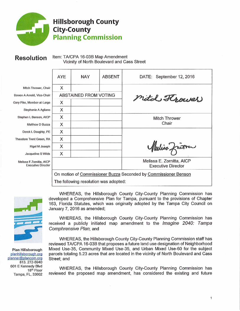
1
Resolution Page 2 Tampa Comprehensive Plan Amendment: TA/CPA 16-03B Map Amendment Vicinity of North Boulevard and Cass Street September 12, 2016
development patterns and community facilities, as well as the adopted goals, objectives and policies of the Imagine 2040: Tampa Comprehensive Plan as follows: Livable City- Goals, Objectives and Policies LU Objective 1.1: Recognize that the City is comprised of five unique districts: University, Central Tampa, Westshore, New Tampa, and South Tampa. LU Policy 1.1.1: Recognize the Central Tampa District as the primary urban employment, civic and cultural center, building upon the heritage assets found in its diverse neighborhoods while fostering a vibrant urban lifestyle through mixed-use development via entertainment and cultural facilities. LU Policy 1.1.6: Encourage transit oriented, pedestrian friendly mixed-use development with attractive and multifunctional corridors through Community Planning efforts in the Westshore, Central Tampa and University planning districts. LU Policy 1.1.7: Continue to consider the development of strategically located mixed-use areas in all districts that accommodate local serving commercial, employment, and entertainment uses. City Design- Goals, Objectives and Policies LU Objective 1.2: Create inspired urban design while respecting Tampa’s human scale, unique history, aesthetics, natural environment, and sense of community identity as the City changes and evolves. LU Policy 1.2.3: Relate new buildings and development to the context of the neighborhood and community. LU Policy 1.2.6: Encourage small and medium scale development, particularly of unique design to enhance Tampa’s urban character. Central City- Goals, Objectives and Policies LU Objective 3.4: Establish the Hillsborough River as the focus of the Center City, creating and linking a series of “River Places” that will promote pedestrian and economic activity and extend value into the community. LU Policy 3.4.1: Encourage more and diverse housing opportunities in the Center City area by amending current land development regulations in a way to promote the development of residential and/or mixed-use residential projects. LU Policy 3.4.2: Encourage new mixed-use developments along and proximate to the Hillsborough River. LU Objective 3.5: Recognize and strengthen Center City neighborhoods, creating a vibrant, diverse, distinctive, inter-connected community.
2
Resolution Page 3 Tampa Comprehensive Plan Amendment: TA/CPA 16-03B Map Amendment Vicinity of North Boulevard and Cass Street September 12, 2016 LU Policy 3.5.2: Create a new mixed-use residential community along the western edge of the Hillsborough River in West Tampa, repositioned with enhanced schools, open space, connected streets and community services. LU Objective 3.6: Transit: Encourage the formation of attractive, vibrant, compact, mixed-use, connected places that will support multi-modal transit alternatives. Urban Villages- Goals, Objectives and Policies LU Objective 5.1: Support the Urban Village designations that produce a distinctive, high-quality built environment whose forms and character respect Tampa’s unique historic, environmental, and architectural context, and create memorable places that enrich community life. LU Policy 5.1.2: Recognize that urban villages are a very livable and sustainable form of development. Continue to emphasize the compact and mixed-use nature of these villages. Look for ways to make it easier to create this type of development pattern. Mixed Use Corridors- Goals, Objectives and Policies LU Objective 6.1: The transformation of major corridors to include a broader mix of uses, both horizontal and vertical, that provides opportunities for medium and higher density housing, while also addressing local and citywide demand for retail and services. LU Policy 6.1.7: The long-term development direction is to create linear mixed-use centers within these corridors. Four types of mixed-use corridor centers are defined based on the scale of the development pattern to be expected. (1) suburban mixed-use scale (refer to the SMU-6 plan category); (2) neighborhood mixed-use scale (refer to the NMU categories); (3) community mixed-use scale (refer to the CMU-35 and CC- 35 plan categories); and (3) urban mixed-use scale (refer to the RMU-100 and UMU-60 plan categories). LU Policy 6.1.8: Each mixed-use corridor should be analyzed with the intent of being developed in harmony with adjacent neighborhoods. The type of corridor village will be determined at that point (i.e. suburban, community serving, or urban scale). Corridors may be divided into several mixed-use corridor villages the size, configuration and type will be determined during the planning process for the corridor. LU Policy 6.1.10: Promote densities, mixes of uses, and transportation improvements that support walking and use of public transportation. LU Policy 6.1.11: Accommodate planned levels of household and employment growth. Depending on the characteristics of each area, establish concentrations of employment and housing at varying densities and with varying mixes of uses. LU Policy 6.1.12: Collaborate with the community in planning for the future.
3
Resolution Page 4 Tampa Comprehensive Plan Amendment: TA/CPA 16-03B Map Amendment Vicinity of North Boulevard and Cass Street September 12, 2016 Urban Neighborhoods LU Objective 9.1: Locate higher density housing in or near the downtown core and medium density housing near employment, shopping and transit facilities to support and encourage pedestrian, bicycle and transit trips. LU Policy 9.1.2: Encourage sensitive design and site planning in urban neighborhoods that mitigates the scale of larger buildings through careful use of building massing, setbacks, facade articulation, fenestration, varied parapets and roof planes, and pedestrian-scaled architectural details. LU Policy 9.1.3: Encourage, where appropriate, higher density urban neighborhoods to include small public spaces and have tree-lined sidewalks furnished with appropriate pedestrian amenities that provide comfortable and attractive settings to accommodate high levels of pedestrian activity. LU Policy 9.1.4: Encourage the vertical and horizontal integration of a complementary mix of commercial, service and other non-residential uses that address the needs of families and other household types living in urban neighborhoods. Such uses may include daycare and school facilities, retail and services, and parks, plazas, and open spaces. Overall Residential Development and Redevelopment – Goals, Objectives, and Policies LU Objective 9.4: Accommodate the greatest concentration of housing in desirable, pedestrian oriented urban areas having convenient access to regional transit stations, where the mix of activity provides convenient access to a full range of residential services and amenities, and opportunities for people to live within walking distance of employment. LU Policy 9.4.1: Encourage higher-density multifamily development in pedestrian-oriented urban areas with access to transit, a broad range of services and amenities and access to employment to:
Encourage housing development of a medium to large scale with heights greater than those in low rise areas;
Accommodate larger scale structures while maintaining the livability of these communities, including measures which minimize the appearance of bulk; or
Promote high-density residential development in Business Centers and Urban Villages. Multifamily Residential Areas LU Objective 9.6: Increase the diversity and improve the sustainability of multi-family residential areas. LU Policy 9.6.2: Promote a residential development pattern consistent with the compact city form strategy, with increased availability of housing at densities that promote walking and transit use near employment concentrations, residential services and amenities.
4

Resolution Page 5 Tampa Comprehensive Plan Amendment: TA/CPA 16-03B Map Amendment Vicinity of North Boulevard and Cass Street September 12, 2016 Mixed Income Residential Neighborhoods LU Objective 9.9: Continue to promote mixed income residential development in the Westshore, Central and University Planning Districts. LU Policy 9.9.1: Encourage mixed-use, mixed-income housing development in Tampa’s new downtown areas of West Tampa, Riverfront and Ybor, the downtown core and along transit lines, consistent with the goals of the Comprehensive Plan’s land use and mobility strategies and InVision Tampa Master Plan. LU Policy 9.9.4: Create, preserve, and provide amenities in the University, Central and Westshore Planning Districts that will provide services for a great urban living space. Neighborhoods/Community Plans- Goals, Objectives, and Policies NE Objective 1.1: A City of diverse, distinct, and well-structured neighborhoods that meet the community’s needs for complete, sustainable, and high-quality living environments from the historic downtown core to well-integrated new growth areas. NE Policy 1.1.2: Continue to protect and enhance single family neighborhoods by providing sensitive transitions between these neighborhoods and adjoining areas, and requiring new development, both private and public, to respect and respond to those existing physical characteristics - buildings, streetscapes, open spaces, and city form that contribute to the overall character and livability of the neighborhood
WHEREAS, the Planning Commission staff has determined that TA/CPA16-03B is consistent with the goals, objectives and policies of the Imagine 2040: Tampa Comprehensive
Plan.
NOW, THEREFORE, BE IT RESOLVED, that the Hillsborough County City-County Planning Commission finds Tampa Comprehensive Plan Amendment TA/CPA 16-03B
CONSISTENT with the Imagine 2040: Tampa Comprehensive Plan and recommends that it be
forwarded to the Tampa City Council for approval.
5
This Page Intentionally Left Blank
6
City of Tampa: TA/CPA 16-03B Vicinity of North Boulevard and Cass Street
Planning Commission Public Hearing: September 12, 2016
7
Future Land Use Map Amendment Summary Information
Application Type Publicly-Initiated
Location Address: 909, 911, 913, 1006, 1008 West Cypress Street 1002, 1007, 1010 West Lemon Street
910, 1001,1010, West Cass Street 707, 711,900, 903, 905, 907 North Delaware Avenue
903 North Gilchrist Avenue
Property Size 5.23 ± acres
Folio Number 179805.0000, 179805.0100, 179806.0000, 179818.0000, 179822.0000, 180939.0000, 180983.0000, 180982.0000, 180979.0000, 180981.0000, 181050.0000, 181052.0000, 181053.0000, 181054.0000, 181055.0000, 180985.0000, 180986.0000, 180987.0000, 180990.0000, 181043.0000, 181046.0000, 181048.0000, 181047.0000
Existing Future Land Use Residential-20 (R-20), Residential-35 (R-35), General Mixed Use-24 (GMU-24)
Proposed Future Land Use Neighborhood Mixed Use-35 (NMU-35), Community Mixed Use-60 (CMU-60), Urban Mixed Use-60 (UMU-60)
Existing Land Use Various (Residential, Commercial, and Vacant)
Roadways North Boulevard is classified as an arterial. West Cass Street and West Cypress Street are classified as collector roadways.
West Arch Street, North Munro Street, North Edison Avenue, and Lemon Street are classified as local roadways.
Neighborhood West Riverfront
Vision Map Designations Central Tampa Planning District and the West Tampa Urban Village
Agency Review Comments All Agency Comments are provided in Attachment B City of Tampa staff finds TA/CPA 16-03B consistent only if TA/CPA16-03A is approved.
Applicable Plan Sections Livable City, Central City, Urban Villages, Mixed Use Corridors, Overall Residential Development, Urban Neighborhoods, Mixed Income Residential Neighborhoods, Commercial Areas
Staff Planner Jennifer Malone, 813-273-3774, ext. 324, [email protected]
Staff Recommendation CONSISTENT
Impact of Proposed Change
The applicant is requesting the following Future Land Use Map designation changes:
Potential Impact Current Land Use Category Proposed Land Use Category
Acres: 0.73+/- Residential-35 (R-35) Urban Mixed Use-60 (UMU-60)
Maximum Density Up to35 dwelling units per gross acre(DU/AC)
Up to 60 dwelling units per gross acre (DU/AC)
Maximum Residential Development Potential
25 DU 43 DU
Range of Allowable Uses Multi-family residential development. Limited neighborhood serving commercial uses consistent with Locational Criteria in the Tampa Comprehensive Plan.
High density multi-family residential development, professional offices and general and intensive commercial uses.
Maximum Floor Area Ratio (FAR)/Non-Residential Development
0.6 FAR/19,204 square feet of non-residential development
3.25 FAR/104,026 square feet of non-residential uses. To encourage a true mixture of uses, residential development may be guided by either density or FAR.
Practical Impacts
The proposed change would increase the density and intensity of the site and encourage mixed use development.
Potential Impact Current Land Use Category Proposed Land Use Category
Acres: 1.83 +/- General Mixed Use-24(GMU-24) Urban Mixed Use-60 (UMU-60)
Maximum Density Up to 24 dwelling units per gross acre(DU/AC)
Up to 60 dwelling units per gross acre (DU/AC)
Maximum Residential Development Potential
43 DU 109 DU
Range of Allowable Uses A mixture of residential, commercial and light industrial.
High density multi-family residential development, professional offices and general and intensive commercial uses.
Maximum Floor Area Ratio (FAR)/Non-Residential Development
1.5 FAR/119,386 square feet of non-residential development
3.25 FAR/258,678 square feet of non-residential uses. To encourage a true mixture of uses, residential development may be guided by either density or FAR.
Practical Impacts
The proposed change would increase the density and intensity of the site and encourage mixed use development.
8
Potential Impact Current Land Use Category Proposed Land Use Category
Acres: 1.12 +/- Residential-35 (R-35) Community Mixed Use-35 (CMU-35)
Maximum Density Up to 35 dwelling units per gross acre(DU/AC)
Up to 35 dwelling units per gross acre (DU/AC)
Maximum Residential
Development Potential 39 DU 39 DU
Range of Allowable Uses Multi-family residential development. Limited neighborhood serving commercial uses consistent with Locational Criteria in the Tampa Comprehensive Plan.
General commercial, professional office and multi-family development (by either density or floor area ratio); gathering places such as a plaza, courtyard, or parks; and compatible public, quasi-public and special uses.
Maximum Floor Area Ratio (FAR)/Non-Residential Development
0.6 FAR/29,393 square feet of non-residential development
2.0 FAR/97,996 square feet of non-residential uses. To encourage a true mixture of uses, residential development may be guided by either density or FAR.
Practical Impacts
The proposed change would increase the density and intensity of the site and encourage mixed use development.
Potential Impact Current Land Use Category Proposed Land Use Category
Acres: 0.77 +/- Residential-35 (R-35) Neighborhood Mixed Use-35 (NMU-35)
Maximum Density Up to 35 dwelling units per gross acre(DU/AC)
Up to 35 dwelling units per gross acre (DU/AC)
Maximum Residential Development Potential
26 DU 26 DU
Range of Allowable Uses Multi-family residential development. Limited neighborhood serving commercial uses consistent with Locational Criteria in the Tampa Comprehensive Plan.
Neighborhood serving office and commercial uses, and single-family and multi-family uses (by either density or floor area ratio); gathering places such as a plaza, courtyard, or parks; and compatible public and quasi-public uses.
Maximum Floor Area Ratio (FAR)/Non-Residential Development
0.6 FAR/20,208 square feet of non-residential development
1.0 FAR, 1.5 FAR for vertical mixed use development/33,621 square feet of non-residential uses or 50,431 square feet of vertical mixed use development. To encourage a true mixture of uses, residential development may be guided by either density or FAR.
Practical Impacts
The proposed would provide for neighborhood scale mixed use development sensitive to the surrounding area.
9

Potential Impact Current Land Use Category Proposed Land Use Category
Acres: 0.77 +/- Residential-20 (R-20) Neighborhood Mixed Use-35 (NMU-35)
Maximum Density Up to 20 dwelling units per gross acre(DU/AC)
Up to 35 dwelling units per gross acre (DU/AC)
Maximum Residential Development Potential
15 DU 26 DU
Range of Allowable Uses Single family residential, two-family, and small scale multi-family development.
Neighborhood serving office and commercial uses, and single-family and multi-family uses (by either density or floor area ratio); gathering places such as a plaza, courtyard, or parks; and compatible public and quasi-public uses.
Maximum Floor Area Ratio (FAR)/Non-Residential Development
0.5 FAR/16,810square feet of non-residential development
1.0 FAR, 1.5 FAR for vertical mixed use development/33,621 square feet of non-residential uses or 50,431 square feet of vertical mixed use development. To encourage a true mixture of uses, residential development may be guided by either density or FAR.
Practical Impacts
The proposed change would provide for neighborhood scale mixed use development sensitive to the surrounding area.
CUMULATIVE TOTAL OF ENTIRE REQUEST
Potential Impacts Current Land Use Category Proposed Land Use Category
Acres: 5.23 +/- acres Residential-20, Residential-35, General Mixed Use-24
Neighborhood Mixed Use-35, Community Mixed Use-35, Urban Mixed Use-60
Maximum Density Up to 20, 35 and 24 dwelling units per gross acre, dependent on Future Land Use designation (DU/AC)
Up to 35, 35 and 60 dwelling units per gross acre, dependent on Future Land Use designation (DU/AC)
Maximum Residential Development Potential
148 DU 244 DU
Maximum Floor Area Ratio (FAR)/Non-Residential Development
The total allowable maximum non-residential square footage that can be considered is 205,004 square feet. Maximum square footage may require development meeting performance measures.
The total allowable maximum non-residential square footage that can be considered is 561,633 square feet. Maximum square footage may require development meeting performance measures.
Practical Impacts
The proposed change would increase the density and intensity of the site, encourage mixed use-development, provide appropriate transitions and neighborhood scaled development, and expand the allowable uses.
10
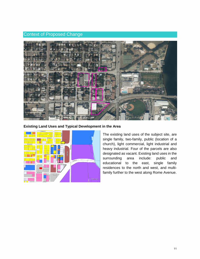
Context of Proposed Change
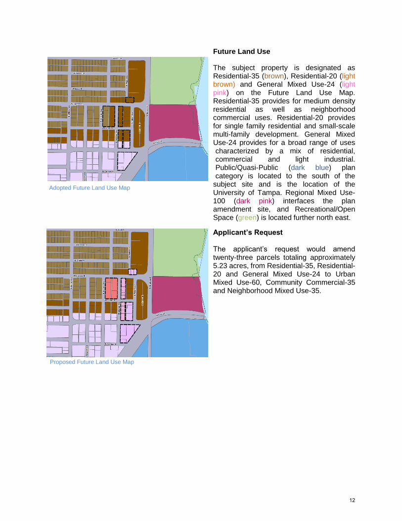
Existing Land Uses and Typical Development in the Area
The existing land uses of the subject site, are
single family, two-family, public (location of a
church), light commercial, light industrial and
heavy industrial. Four of the parcels are also
designated as vacant. Existing land uses in the
surrounding area include: public and
educational to the east, single family
residences to the north and west, and multi-
family further to the west along Rome Avenue.
11
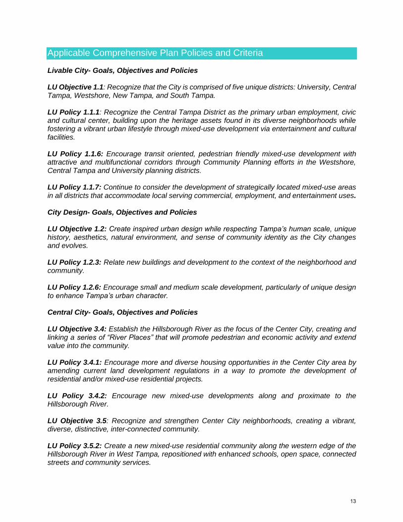
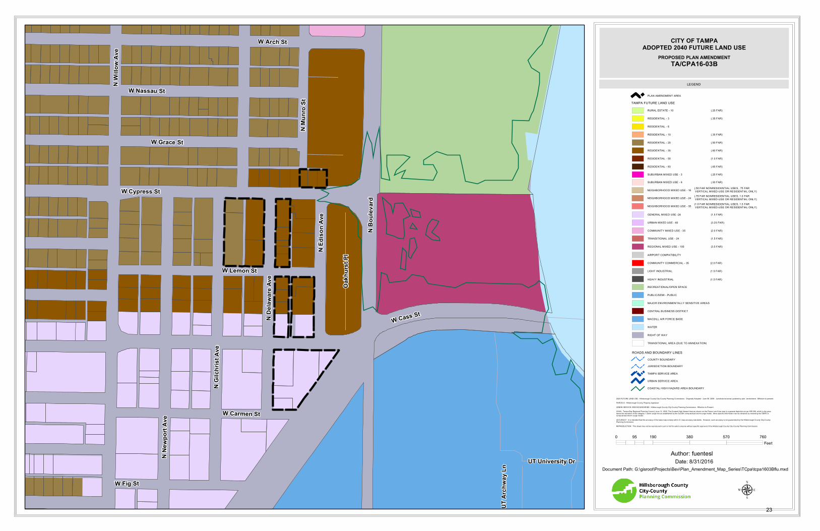
Future Land Use
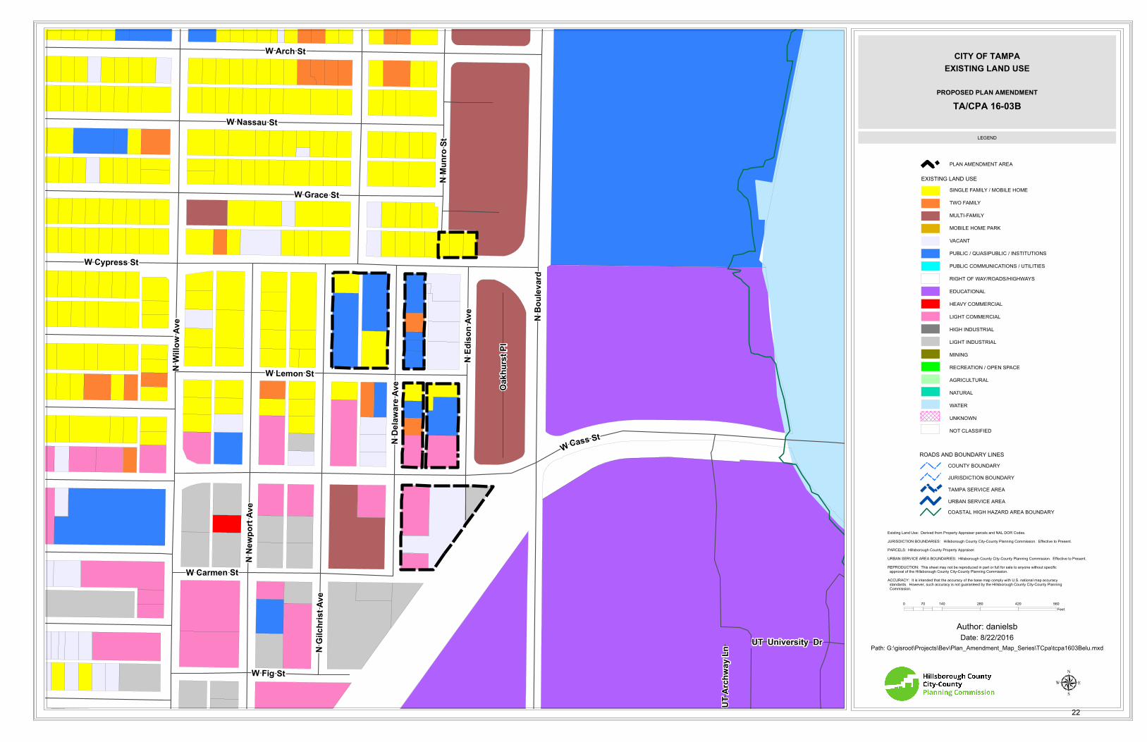
The subject property is designated as Residential-35 (brown), Residential-20 (light brown) and General Mixed Use-24 (light pink) on the Future Land Use Map. Residential-35 provides for medium density residential as well as neighborhood commercial uses. Residential-20 provides for single family residential and small-scale multi-family development. General Mixed Use-24 provides for a broad range of uses characterized by a mix of residential, commercial and light industrial. Public/Quasi-Public (dark blue) plan category is located to the south of the
subject site and is the location of the University of Tampa. Regional Mixed Use-100 (dark pink) interfaces the plan amendment site, and Recreational/Open Space (green) is located further north east.
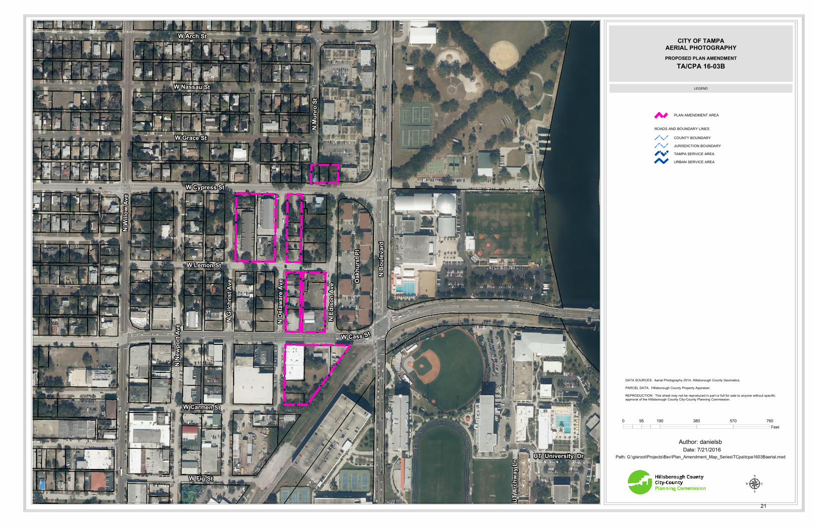
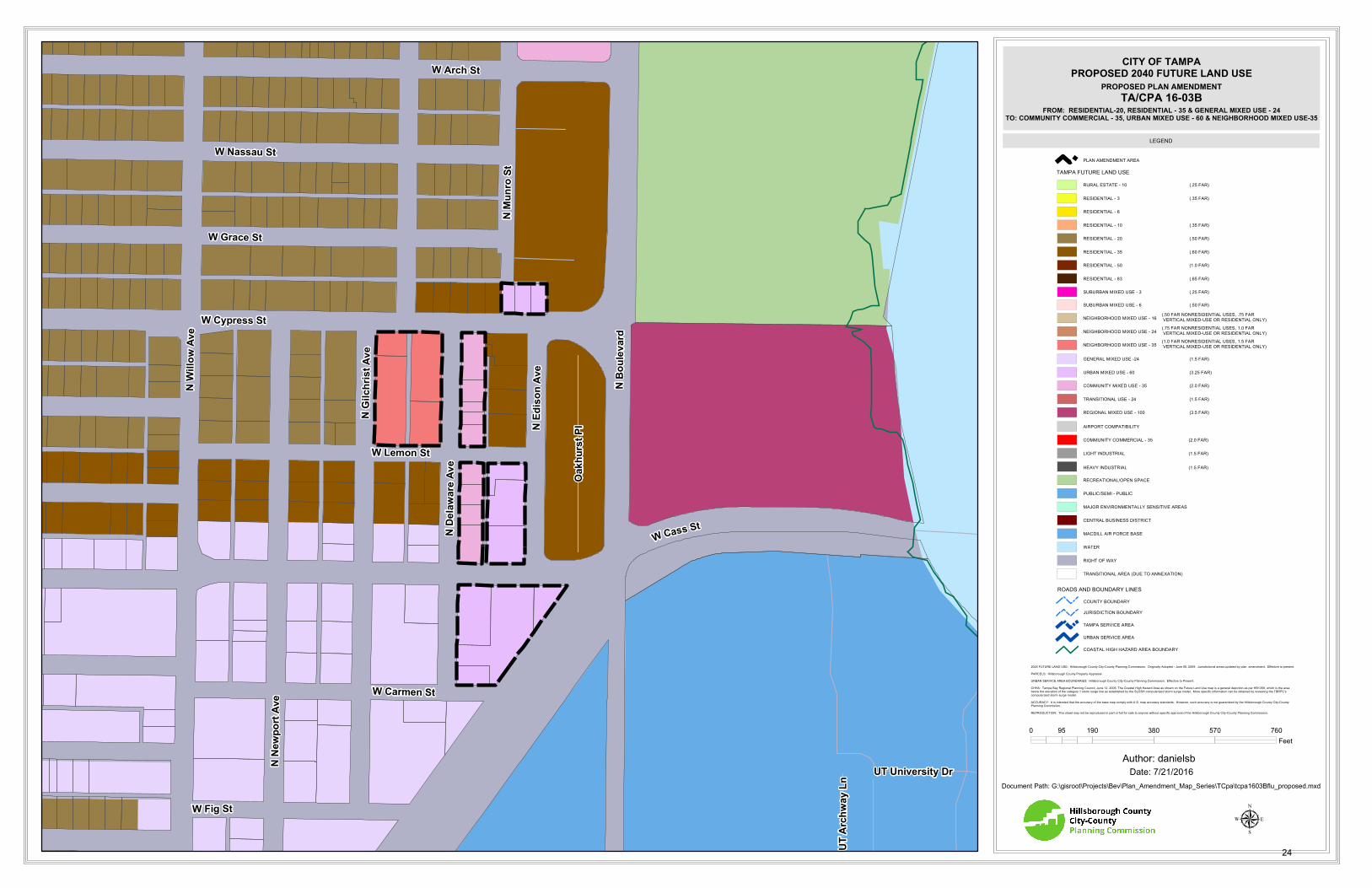
Applicant’s Request The applicant’s request would amend twenty-three parcels totaling approximately 5.23 acres, from Residential-35, Residential-20 and General Mixed Use-24 to Urban Mixed Use-60, Community Commercial-35 and Neighborhood Mixed Use-35.
Existing Land Use Map
Adopted Future Land Use Map
Proposed Future Land Use Map
12
Applicable Comprehensive Plan Policies and Criteria
Livable City- Goals, Objectives and Policies LU Objective 1.1: Recognize that the City is comprised of five unique districts: University, Central Tampa, Westshore, New Tampa, and South Tampa. LU Policy 1.1.1: Recognize the Central Tampa District as the primary urban employment, civic and cultural center, building upon the heritage assets found in its diverse neighborhoods while fostering a vibrant urban lifestyle through mixed-use development via entertainment and cultural facilities. LU Policy 1.1.6: Encourage transit oriented, pedestrian friendly mixed-use development with attractive and multifunctional corridors through Community Planning efforts in the Westshore, Central Tampa and University planning districts. LU Policy 1.1.7: Continue to consider the development of strategically located mixed-use areas in all districts that accommodate local serving commercial, employment, and entertainment uses. City Design- Goals, Objectives and Policies LU Objective 1.2: Create inspired urban design while respecting Tampa’s human scale, unique history, aesthetics, natural environment, and sense of community identity as the City changes and evolves. LU Policy 1.2.3: Relate new buildings and development to the context of the neighborhood and community. LU Policy 1.2.6: Encourage small and medium scale development, particularly of unique design to enhance Tampa’s urban character. Central City- Goals, Objectives and Policies LU Objective 3.4: Establish the Hillsborough River as the focus of the Center City, creating and linking a series of “River Places” that will promote pedestrian and economic activity and extend value into the community. LU Policy 3.4.1: Encourage more and diverse housing opportunities in the Center City area by amending current land development regulations in a way to promote the development of residential and/or mixed-use residential projects. LU Policy 3.4.2: Encourage new mixed-use developments along and proximate to the Hillsborough River. LU Objective 3.5: Recognize and strengthen Center City neighborhoods, creating a vibrant, diverse, distinctive, inter-connected community. LU Policy 3.5.2: Create a new mixed-use residential community along the western edge of the Hillsborough River in West Tampa, repositioned with enhanced schools, open space, connected streets and community services.
13
LU Objective 3.6: Transit: Encourage the formation of attractive, vibrant, compact, mixed-use, connected places that will support multi-modal transit alternatives. Urban Villages- Goals, Objectives and Policies LU Objective 5.1: Support the Urban Village designations that produce a distinctive, high-quality built environment whose forms and character respect Tampa’s unique historic, environmental, and architectural context, and create memorable places that enrich community life. LU Policy 5.1.2: Recognize that urban villages are a very livable and sustainable form of development. Continue to emphasize the compact and mixed-use nature of these villages. Look for ways to make it easier to create this type of development pattern. Mixed Use Corridors- Goals, Objectives and Policies LU Objective 6.1: The transformation of major corridors to include a broader mix of uses, both horizontal and vertical, that provides opportunities for medium and higher density housing, while also addressing local and citywide demand for retail and services. LU Policy 6.1.7: The long-term development direction is to create linear mixed-use centers within these corridors. Four types of mixed-use corridor centers are defined based on the scale of the development pattern to be expected. (1) suburban mixed-use scale (refer to the SMU-6 plan category); (2) neighborhood mixed-use scale (refer to the NMU categories); (3) community mixed-use scale (refer to the CMU-35 and CC- 35 plan categories); and (3) urban mixed-use scale (refer to the RMU-100 and UMU-60 plan categories). LU Policy 6.1.8: Each mixed-use corridor should be analyzed with the intent of being developed in harmony with adjacent neighborhoods. The type of corridor village will be determined at that point (i.e. suburban, community serving, or urban scale). Corridors may be divided into several mixed-use corridor villages the size, configuration and type will be determined during the planning process for the corridor. LU Policy 6.1.10: Promote densities, mixes of uses, and transportation improvements that support walking and use of public transportation. LU Policy 6.1.11: Accommodate planned levels of household and employment growth. Depending on the characteristics of each area, establish concentrations of employment and housing at varying densities and with varying mixes of uses. LU Policy 6.1.12: Collaborate with the community in planning for the future. Urban Neighborhoods LU Objective 9.1: Locate higher density housing in or near the downtown core and medium density housing near employment, shopping and transit facilities to support and encourage pedestrian, bicycle and transit trips. LU Policy 9.1.2: Encourage sensitive design and site planning in urban neighborhoods that mitigates the scale of larger buildings through careful use of building massing, setbacks, facade
14
articulation, fenestration, varied parapets and roof planes, and pedestrian-scaled architectural details. LU Policy 9.1.3: Encourage, where appropriate, higher density urban neighborhoods to include small public spaces and have tree-lined sidewalks furnished with appropriate pedestrian amenities that provide comfortable and attractive settings to accommodate high levels of pedestrian activity. LU Policy 9.1.4: Encourage the vertical and horizontal integration of a complementary mix of commercial, service and other non-residential uses that address the needs of families and other household types living in urban neighborhoods. Such uses may include daycare and school facilities, retail and services, and parks, plazas, and open spaces. Overall Residential Development and Redevelopment – Goals, Objectives, and Policies LU Objective 9.4: Accommodate the greatest concentration of housing in desirable, pedestrian oriented urban areas having convenient access to regional transit stations, where the mix of activity provides convenient access to a full range of residential services and amenities, and opportunities for people to live within walking distance of employment. LU Policy 9.4.1: Encourage higher-density multifamily development in pedestrian-oriented urban areas with access to transit, a broad range of services and amenities and access to employment to:
Encourage housing development of a medium to large scale with heights greater than those in low rise areas;
Accommodate larger scale structures while maintaining the livability of these communities, including measures which minimize the appearance of bulk; or
Promote high-density residential development in Business Centers and Urban Villages.
Multifamily Residential Areas LU Objective 9.6: Increase the diversity and improve the sustainability of multi-family residential areas. LU Policy 9.6.2: Promote a residential development pattern consistent with the compact city form strategy, with increased availability of housing at densities that promote walking and transit use near employment concentrations, residential services and amenities. Mixed Income Residential Neighborhoods LU Objective 9.9: Continue to promote mixed income residential development in the Westshore, Central and University Planning Districts. LU Policy 9.9.1: Encourage mixed-use, mixed-income housing development in Tampa’s new downtown areas of West Tampa, Riverfront and Ybor, the downtown core and along transit lines, consistent with the goals of the Comprehensive Plan’s land use and mobility strategies and InVision Tampa Master Plan.
15
Neighborhoods/Community Plans- Goals, Objectives, and Policies NE Objective 1.1: A City of diverse, distinct, and well-structured neighborhoods that meet the community’s needs for complete, sustainable, and high-quality living environments from the historic downtown core to well-integrated new growth areas. NE Policy 1.1.2: Continue to protect and enhance single family neighborhoods by providing sensitive transitions between these neighborhoods and adjoining areas, and requiring new development, both private and public, to respect and respond to those existing physical characteristics - buildings, streetscapes, open spaces, and city form that contribute to the overall character and livability of the neighborhood.
Staff Analysis
The subject property is comprised of twenty-three parcels and totals approximately 5.23 acres. The subject site is located within the West Tampa Overlay District, West Tampa Urban Village and within the limits of the West Tampa Community Redevelopment Area (CRA). The subject property is surrounded by residential, public and industrial land uses. East across North Boulevard is Julian B. Lane Riverfront Park, Tampa Preparatory School, and the University of Tampa, which all boarder the Hillsborough River. The Central Business District, also referred to as Downtown Tampa, is located further east, across the Hillsborough River. The Julian B. Lane Riverfront Park is currently undergoing an extensive renovation. When complete, this park will be a significant public gathering space for the community along the Hillsborough River. The development trend west along Cass and Cypress Streets, headed west towards Rome Avenue, has experienced a residential transition over the last decade to higher residential density projects. Several multi-family developments have recently been constructed along Rome Avenue. The area still has some evidence of what once was an industrial presence, with several of the existing warehouses in proximity of the new developments having been repurposed as gyms, shops, or still functioning as industrial uses. An established single-family neighborhood does exist north of Cypress Street, south of Interstate-275. However, with most of the land between Cypress and Cass Streets, both collector roads, consisting mostly of underutilized land with higher residential future land use designations proximate to the urban core, the opportunity for higher density development and shorter transit trips exists and continues to be the trend. The plan amendment site is located within the West Tampa Urban Village, on the eastern edge of the West Riverfront neighborhood. The purpose of the Urban Village is to cultivate a high quality built environment whose character represents Tampa’s historical context. The area has recently experienced a renewed interest in development with its unique characteristics, historical context and close proximity to Downtown Tampa. The Tampa Comprehensive Plan recognizes the importance of Urban Villages as livable and sustainable forms of development, and encourages fostering and creating compact mixed use development patterns within the Urban Village (LU Policy 5.1.2). In addition to its designation as part of the West Tampa Urban Village, the plan amendment site was also part of the InVision Tampa, Tampa Center City Plan (Center City Plan). The Center City Plan was a master planning effort conducted by the City of Tampa working with the Urban Land Institute and AECOM. The result is a comprehensive and holistic vision of Downtown Tampa and the neighborhoods to the west, north and east, referred to as the Center City neighborhoods. The
16
City of Tampa, Urban Land Institute and AECOM solicited public engagement from community members, working to determine the values and long term desires of the residents of the Center City neighborhoods. Transit is also an important component of the Center City neighborhoods; the Tampa Comprehensive Plan promotes increasing density in areas where transit service is available (LU Policy 9.6.2). Transit Service is currently provided in the rea (HART Route #7, #14) connecting the site to the West Tampa, Yukon Transfer Center and Marion Transfer Centers, and Hillsborough Community College - Dale Mabry Campus. The proposed land use categories, Urban Mixed Use-60, Community Mixed Use-35 and Neighborhood Mixed Use-35 would allow for higher density along arterial roadways (North Boulevard) and less intensity further west along Cypress Street. The result, if both TA/CPA 16-03A and TA/CPA 16-03B are approved, is a holistic land use plan for the area, in which higher density growth is concentrated along an arterial roadway (North Boulevard) and transitions to an intensity appropriate for the surrounding neighborhood. The proposed Community Mixed Use-35 and Neighborhood Mixed Use-35 land use categories will provide an appropriate buffer between the proposed Urban Mixed Use-60 and the existing Residential-20 the north and Residential-35 to the south (NE Policy 1.1.2). Overall, the Urban Mixed Use-60, Community Mixed Use-35 and Neighborhood Mixed Use-35 plan categories would provide for neighborhood scale mixed use development and high density mixed use development in the appropriate areas. These plan amendments fit the vision articulated by the community in the Center City Plan and the policy direction of the Tampa Comprehensive Plan. This amendment will complement TA/CPA 16-03A, providing for more opportunities for a vibrant mixed use center near the Hillsborough River, in an area where growth is encouraged by policy direction in the Tampa Comprehensive Plan.
Recommendation
Staff recommends that the Planning Commission find the proposed future land use designation change for Tampa Plan Amendment TA/CPA 16-03B from Residential-35, Residential-20 and General Mixed Use-24 to Urban Mixed Use-60, Community Mixed Use-35 and Neighborhood Mixed Use-35 CONSISTENT with the Imagine 2040: Tampa Comprehensive Plan, predicated on the approval of TA/CPA 16-03A, and forward this recommendation to Tampa City Council.
17
This Page Intentionally Left Blank
18
Attachment A
Map Series
1. Aerial Map 2. Existing Land Use Map 3. Adopted Future Land Use Map 4. Proposed Future Land Use Map Change
19
This Page Intentionally Left Blank
20
NWi
ll ow
Ave
N Mu
nro S
t
N Bo
uleva
rd
W Fig St
W Cypress StN
Newp
o rt A
v e
NE d
is on A
veW Cass St
W Lemon St
W Carmen St
W Nassau St
W Arch St
W Grace St
NDe
lawa re
Ave
NGi
lc hr is
t Av e Oa
khur
st Pl
UT University Dr
UTAr
chwa
yLn
0 190 380 570 76095Feet
µ
Date: 7/21/2016Path: G:\gisroot\Projects\Bev\Plan_Amendment_Map_Series\TCpa\tcpa1603Baerial.mxd
DATA SOURCES: Aerial Photography 2014, Hillsborough County Geomatics. PARCEL DATA: Hillsborough County Property Appraiser.REPRODUCTION: This sheet may not be reproduced in part or full for sale to anyone without specificapproval of the Hillsborough County City-County Planning Commission.
LEGEND
Author: danielsb
ROADS AND BOUNDARY LINES
COUNTY BOUNDARYJURISDICTION BOUNDARY
URBAN SERVICE AREA
PLAN AMENDMENT AREA
TAMPA SERVICE AREA
CITY OF TAMPAAERIAL PHOTOGRAPHY
TA/CPA 16-03BPROPOSED PLAN AMENDMENT
21
NWi
ll ow
Ave
N Mu
nro S
t
N Bo
uleva
rd
W Fig St
W Cypress StN
Newp
o rt A
ve
NE d
i son A
v eWCass St
W Lemon St
W Carmen St
W Nassau St
W Arch St
W Grace St
NDe
la wa re
A ve
NGi
lc hris
t Ave
Oakh
urst
Pl
UT University Dr
UTAr
chwa
yLn
Existing Land Use: Derived from Property Appraiser parcels and NAL DOR Codes.JURISDICTION BOUNDARIES: Hillsborough County City-County Planning Commission. Effective to Present.PARCELS: Hillsborough County Property Appraiser.URBAN SERVICE AREA BOUNDARIES: Hillsborough County City-County Planning Commission. Effective to Present.REPRODUCTION: This sheet may not be reproduced in part or full for sale to anyone without specific approval of the Hillsborough County City-County Planning Commission.ACCURACY: It is intended that the accuracy of the base map comply with U.S. national map accuracy standards. However, such accuracy is not guaranteed by the Hillsborough County City-County Planning Commission.
Date: 8/22/2016
µ
0 140 280 420 56070Feet
Path: G:\gisroot\Projects\Bev\Plan_Amendment_Map_Series\TCpa\tcpa1603Belu.mxd
LEGEND
Author: danielsb
SINGLE FAMILY / MOBILE HOME
TWO FAMILY
MULTI-FAMILY
MOBILE HOME PARK
VACANT
PUBLIC / QUASIPUBLIC / INSTITUTIONS
PUBLIC COMMUNICATIONS / UTILITIES
RIGHT OF WAY/ROADS/HIGHWAYS
EDUCATIONAL
HEAVY COMMERCIAL
LIGHT COMMERCIAL
HIGH INDUSTRIAL
LIGHT INDUSTRIAL
MINING
RECREATION / OPEN SPACE
AGRICULTURAL
NATURAL
WATER
UNKNOWN
NOT CLASSIFIED
CITY OF TAMPA
TA/CPA 16-03B
PLAN AMENDMENT AREA
EXISTING LAND USE
ROADS AND BOUNDARY LINESCOUNTY BOUNDARYJURISDICTION BOUNDARY
URBAN SERVICE AREACOASTAL HIGH HAZARD AREA BOUNDARY
TAMPA SERVICE AREA
PROPOSED PLAN AMENDMENT
EXISTING LAND USE
22
Document Path: G:\gisroot\Projects\Bev\Plan_Amendment_Map_Series\TCpa\tcpa1603Bflu.mxd
LEGEND
CITY OF TAMPAADOPTED 2040 FUTURE LAND USE
Date: 8/31/2016Author: fuentesl
NWi
llow
Ave
N Mu
nro S
t
N Bo
uleva
rd
W Fig St
W Cypress St
NNe
wpo r
tAv e
NE d
isonA
v eW Cass St
W Lemon St
W Carmen St
W Nassau St
W Arch St
W Grace St
NDe
la war e
Ave
NGi
lchr is
t Ave
Oakh
urst
Pl
UT University Dr
UTAr
chwa
yLn
TA/CPA16-03B
2025 FUTURE LAND USE: Hillsborough County City-County Planning Commission. Originally Adopted - June 08, 2009. Jurisdicitonal areas updated by plan amendment. Effective to present.PARCELS: Hillsborough County Property Appraiser.
URBAN SERVICE AREA BOUNDARIES: Hillsborough County City-County Planning Commission. Effective to Present.CHHA: Tampa Bay Regional Planning Council, June 12, 2006. The Coastal High Hazard Area as shown on the Future Land Use map is a general depiction as per HB1359, which is the areabelow the elevation of the category 1 storm surge line as established by the SLOSH computerized storm surge model. More specific information can be obtained by reviewing the TBRPC's computerized storm surge model.
ACCURACY: It is intended that the accuracy of the base map comply with U.S. map accuracy standards. However, such accuracy is not guaranteed by the Hillsborough County City-CountyPlanning Commisiion.REPRODUCTION: This sheet may not be reproduced in part or full for sale to anyone without specific approval of the Hillsborough County City-County Planning Commission.
0 190 380 570 76095Feet
µ
PROPOSED PLAN AMENDMENT
TAMPA SERVICE AREA
ROADS AND BOUNDARY LINESCOUNTY BOUNDARY
JURISDICTION BOUNDARY
URBAN SERVICE AREA
COASTAL HIGH HAZARD AREA BOUNDARY
PLAN AMENDMENT AREA
TAMPA FUTURE LAND USE
GENERAL MIXED USE -24
REGIONAL MIXED USE - 100
TRANSITIONAL USE - 24
SUBURBAN MIXED USE - 3
SUBURBAN MIXED USE - 6
URBAN MIXED USE - 60
COMMUNITY MIXED USE - 35
RURAL ESTATE - 10
RESIDENTIAL - 6
RESIDENTIAL - 83
RESIDENTIAL - 50
RESIDENTIAL - 10
RESIDENTIAL - 20
RESIDENTIAL - 35
RESIDENTIAL - 3
(1.5 FAR)
(3.5 FAR)
(1.5 FAR)
(.25 FAR)
(.50 FAR)
(3.25 FAR)
(2.0 FAR)
(.65 FAR)
(1.0 FAR)
(.35 FAR)
(.50 FAR)
(.60 FAR)
(.25 FAR)
(.35 FAR)
MACDILL AIR FORCE BASE
RECREATIONAL/OPEN SPACE
PUBLIC/SEMI - PUBLIC
MAJOR ENVIRONMENTALLY SENSITIVE AREAS
HEAVY INDUSTRIAL (1.5 FAR)
LIGHT INDUSTRIAL (1.5 FAR)
COMMUNITY COMMERCIAL - 35 (2.0 FAR)
AIRPORT COMPATIBILITY
CENTRAL BUSINESS DISTRICT
WATER
RIGHT OF WAY
TRANSITIONAL AREA (DUE TO ANNEXATION)
NEIGHBORHOOD MIXED USE - 16
NEIGHBORHOOD MIXED USE - 24
NEIGHBORHOOD MIXED USE - 35
(.50 FAR NONRESIDENTIAL USES, .75 FAR VERTICAL MIXED-USE OR RESIDENTIAL ONLY)(.75 FAR NONRESIDENTIAL USES, 1.0 FAR VERTICAL MIXED-USE OR RESIDENTIAL ONLY)(1.0 FAR NONRESIDENTIAL USES, 1.5 FAR VERTICAL MIXED-USE OR RESIDENTIAL ONLY)
23
Document Path: G:\gisroot\Projects\Bev\Plan_Amendment_Map_Series\TCpa\tcpa1603Bflu_proposed.mxd
LEGEND
CITY OF TAMPAPROPOSED 2040 FUTURE LAND USE
Date: 7/21/2016Author: danielsb
NWi
llow
Ave
N Mu
nro S
t
N Bo
uleva
rd
W Fig St
W Cypress St
NNe
wpo r
t Ave
NE d
i son A
v eW Cass St
W Lemon St
W Carmen St
W Nassau St
W Arch St
W Grace St
NDe
l awar e
A ve
NGi
lc hr is
t Ave
Oakh
urst
Pl
UT University Dr
UTAr
chwa
yLn
TA/CPA 16-03BFROM: RESIDENTIAL-20, RESIDENTIAL - 35 & GENERAL MIXED USE - 24
TO: COMMUNITY COMMERCIAL - 35, URBAN MIXED USE - 60 & NEIGHBORHOOD MIXED USE-35
0 190 380 570 76095Feet
µ
PROPOSED PLAN AMENDMENT
TAMPA SERVICE AREA
ROADS AND BOUNDARY LINESCOUNTY BOUNDARY
JURISDICTION BOUNDARY
URBAN SERVICE AREA
COASTAL HIGH HAZARD AREA BOUNDARY
PLAN AMENDMENT AREA
TAMPA FUTURE LAND USE
GENERAL MIXED USE -24
REGIONAL MIXED USE - 100
TRANSITIONAL USE - 24
SUBURBAN MIXED USE - 3
SUBURBAN MIXED USE - 6
URBAN MIXED USE - 60
COMMUNITY MIXED USE - 35
RURAL ESTATE - 10
RESIDENTIAL - 6
RESIDENTIAL - 83
RESIDENTIAL - 50
RESIDENTIAL - 10
RESIDENTIAL - 20
RESIDENTIAL - 35
RESIDENTIAL - 3
(1.5 FAR)
(3.5 FAR)
(1.5 FAR)
(.25 FAR)
(.50 FAR)
(3.25 FAR)
(2.0 FAR)
(.65 FAR)
(1.0 FAR)
(.35 FAR)
(.50 FAR)
(.60 FAR)
(.25 FAR)
(.35 FAR)
MACDILL AIR FORCE BASE
RECREATIONAL/OPEN SPACE
PUBLIC/SEMI - PUBLIC
MAJOR ENVIRONMENTALLY SENSITIVE AREAS
HEAVY INDUSTRIAL (1.5 FAR)
LIGHT INDUSTRIAL (1.5 FAR)
COMMUNITY COMMERCIAL - 35 (2.0 FAR)
AIRPORT COMPATIBILITY
CENTRAL BUSINESS DISTRICT
WATER
RIGHT OF WAY
TRANSITIONAL AREA (DUE TO ANNEXATION)
NEIGHBORHOOD MIXED USE - 16
NEIGHBORHOOD MIXED USE - 24
NEIGHBORHOOD MIXED USE - 35
(.50 FAR NONRESIDENTIAL USES, .75 FAR VERTICAL MIXED-USE OR RESIDENTIAL ONLY)(.75 FAR NONRESIDENTIAL USES, 1.0 FAR VERTICAL MIXED-USE OR RESIDENTIAL ONLY)(1.0 FAR NONRESIDENTIAL USES, 1.5 FAR VERTICAL MIXED-USE OR RESIDENTIAL ONLY)
2025 FUTURE LAND USE: Hillsborough County City-County Planning Commission. Originally Adopted - June 08, 2009. Jurisdicitonal areas updated by plan amendment. Effective to present.
PARCELS: Hillsborough County Property Appraiser.URBAN SERVICE AREA BOUNDARIES: Hillsborough County City-County Planning Commission. Effective to Present.
CHHA: Tampa Bay Regional Planning Council, June 12, 2006. The Coastal High Hazard Area as shown on the Future Land Use map is a general depiction as per HB1359, which is the areabelow the elevation of the category 1 storm surge line as established by the SLOSH computerized storm surge model. More specific information can be obtained by reviewing the TBRPC's computerized storm surge model.
ACCURACY: It is intended that the accuracy of the base map comply with U.S. map accuracy standards. However, such accuracy is not guaranteed by the Hillsborough County City-CountyPlanning Commisiion.
REPRODUCTION: This sheet may not be reproduced in part or full for sale to anyone without specific approval of the Hillsborough County City-County Planning Commission.
24
Attachment B
Agency Comments
25

This Page Intentionally Left Blank
26
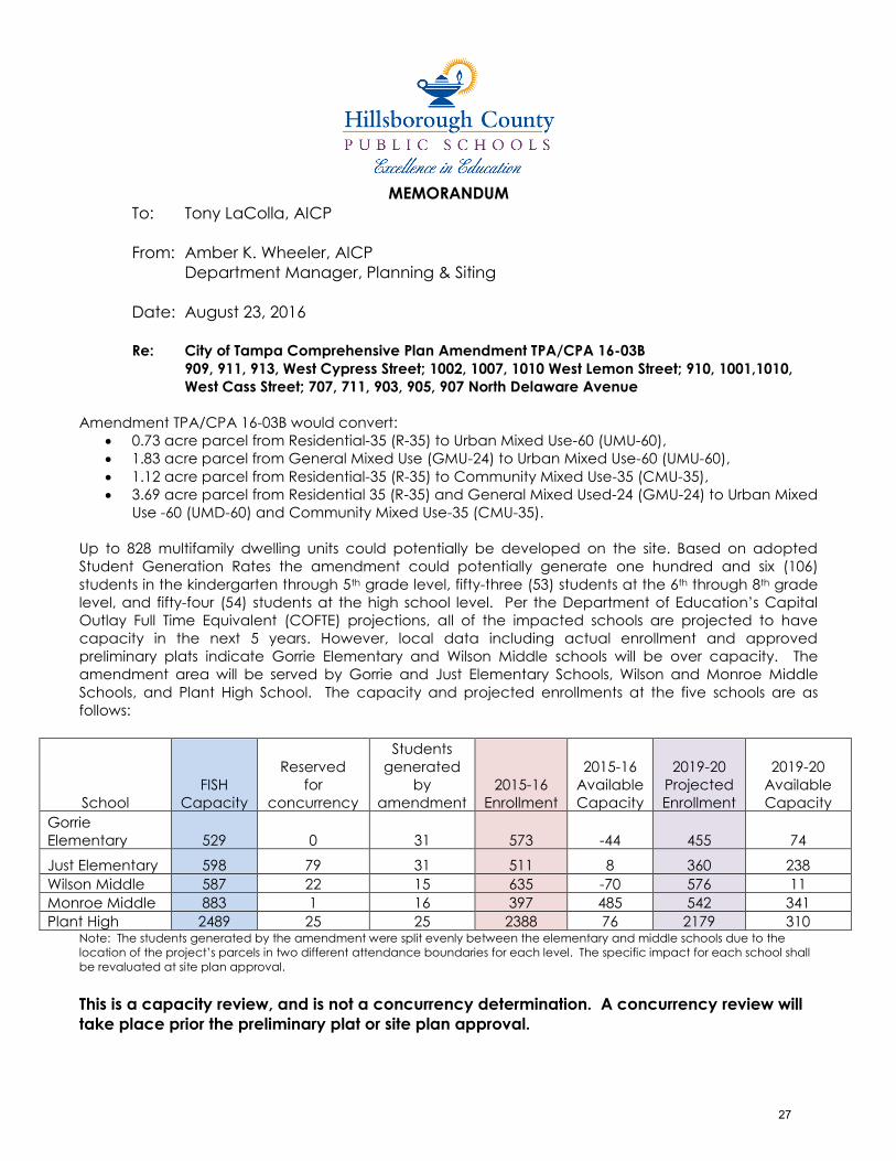
MEMORANDUM
To: Tony LaColla, AICP
From: Amber K. Wheeler, AICP
Department Manager, Planning & Siting
Date: August 23, 2016
Re: City of Tampa Comprehensive Plan Amendment TPA/CPA 16-03B
909, 911, 913, West Cypress Street; 1002, 1007, 1010 West Lemon Street; 910, 1001,1010,
West Cass Street; 707, 711, 903, 905, 907 North Delaware Avenue
Amendment TPA/CPA 16-03B would convert:
0.73 acre parcel from Residential-35 (R-35) to Urban Mixed Use-60 (UMU-60),
1.83 acre parcel from General Mixed Use (GMU-24) to Urban Mixed Use-60 (UMU-60),
1.12 acre parcel from Residential-35 (R-35) to Community Mixed Use-35 (CMU-35),
3.69 acre parcel from Residential 35 (R-35) and General Mixed Used-24 (GMU-24) to Urban Mixed
Use -60 (UMD-60) and Community Mixed Use-35 (CMU-35).
Up to 828 multifamily dwelling units could potentially be developed on the site. Based on adopted
Student Generation Rates the amendment could potentially generate one hundred and six (106)
students in the kindergarten through 5th grade level, fifty-three (53) students at the 6th through 8th grade
level, and fifty-four (54) students at the high school level. Per the Department of Education’s Capital
Outlay Full Time Equivalent (COFTE) projections, all of the impacted schools are projected to have
capacity in the next 5 years. However, local data including actual enrollment and approved
preliminary plats indicate Gorrie Elementary and Wilson Middle schools will be over capacity. The
amendment area will be served by Gorrie and Just Elementary Schools, Wilson and Monroe Middle
Schools, and Plant High School. The capacity and projected enrollments at the five schools are as
follows:
School
FISH
Capacity
Reserved
for
concurrency
Students
generated
by
amendment
2015-16
Enrollment
2015-16
Available
Capacity
2019-20
Projected
Enrollment
2019-20
Available
Capacity
Gorrie
Elementary 529 0 31 573 -44 455
74
Just Elementary 598 79 31 511 8 360 238
Wilson Middle 587 22 15 635 -70 576 11
Monroe Middle 883 1 16 397 485 542 341
Plant High 2489 25 25 2388 76 2179 310 Note: The students generated by the amendment were split evenly between the elementary and middle schools due to the
location of the project’s parcels in two different attendance boundaries for each level. The specific impact for each school shall
be revaluated at site plan approval.
This is a capacity review, and is not a concurrency determination. A concurrency review will
take place prior the preliminary plat or site plan approval.
27
28
29
Comprehensive Plan Amendment Request TA/CPA 16-03 A and B
Transportation Information
Road Name From - To Number of Lanes
Adopted LOS
Standard
Current LOS
Pedestrian LOS
Bicycle LOS
North Blvd. Cass St. to Laurel St.
4LD D C B B
W. Cypress St.
Willow Ave to N. Boulevard
2LU D C B C
W. Cass St. Willow Ave to N. Boulevard
4LU D C B C
Transportation Analysis – Existing Access to the site is from North Blvd., W. Cypress St., and W. Cass St. There are sidewalks and bicycle lanes on both North Blvd. and W. Cass St. Cypress St. has sidewalks but no designated bicycle facilities. Currently, HART provides bus service in this area. Transportation Analysis – Future Proposed Capacity is currently being added to I-275 in this area. This project is in the 5 year Transportation Improvement Program and the 2040 Long Range Transportation Plan. The current 2040 Long Range Transportation Plan identifies a Light Rail Transit or Modern Streetcar route (from Downtown to the Westshore area) that would pass through this area. Also, the City of Tampa’s “Green Spine” project is proposed along Cass St. in this area. The HART Transit Development Plan identifies the need for expansion of transit service in this area, (including MertoRapid service on Kennedy Blvd.). Special Area Analysis This area is identified in the MPO’s Demographic Analysis for Environmental Justice Purposes as an area having a high density of minority populations. *This is a cursory transportation assessment. Once a site plan has been revealed, a more detailed Transportation Impact Assessment should be performed.
30
STAFF REPORT ON C COMPREHENSIVE PLAN AMENDMENT
APPLICATION: CPA 16-03B HEARING DATE: SEPTEMBER 12, 2016
PROPERTY ADDRESS: CURRENT FUTURE LAND USE: REQUESTED FUTURE LAND USE:
909, 911, & 913 W CYPRESS ST, 1002 W LEMON ST
910, 1001, 1010 W CASS ST
RESIDENTIAL-35
GENERAL MIXED USE-24 URBAN MIXED USE-60
707, 711, 903, 905, & 907 N DELAWARE AVE, 1007 & 1010 W LEMON ST
1003 W CASS ST
RESIDENTIAL-35
GENERAL MIXED USE-24
COMMUNITY MIXED USE-35
1008 W CYPRESS ST & 903 N GILCHRIST AVE
1006 W CYPRESS ST & 900 N DELAWARE AVE RESIDENTIAL-20
RESIDENTIAL-35 NEIGHBORHOOD MIXED
USE-35
GENERAL DESCRIPTION OF SITE The subject parcels contain 5.23± acres or 227,891.02± square feet. The overall site is located in the general vicinity south of I-275, west of North Boulevard, and west of the River. The most northern parcels are located on West Cypress Street, west of North Boulevard, east of Delaware Avenue. The most southern parcels are bounded by West Carmen Street to the south, North Delaware Avenue to the west, West Cass Street to the north, and North Boulevard to the east. The subject site is located in the West Tampa Urban Village and Central Tampa Planning district and is a part of the newly created West Tampa Community Redevelopment Area. The subject site currently has multiple zoning designations: RM-24 Residential Multiple-family, RS-50 Residential Single-family, CI Commercial Intensive, and IG Industrial General. The parcels located along North Delaware Avenue are zoned RS-50. This district provides areas for primarily low density single-family detached dwellings. The parcels bordered by West Lemon Street to the north, N Edison to the East, and the alley between North Delaware and Edison Avenues are zoned RS-50 and CI. This district provides areas for primarily low density single-family detached dwellings. This district provides primarily for medium density multiple-family residential development. The parcels located between North Edison and Delaware Avenues are zoned RS-50 The subject property is adjacent to single family residential to the west, a park and a private school to the east, offices to the north, and a mix of commercial and warehousing uses south of West Cass Street.
PROPOSED FUTURE LAND USE DESIGNATION The proposed future land use categories of Community Mixed Use-35 (CMU-35), Neighborhood Mixed Use-35 (NMU-35), and Urban Mixed Use-60 (UMU-60) would allow for the consideration of any of the allowable zoning districts from residential through commercial. The most intensive development could occur with the IG Industrial General zoning district which provides for intense commercial activity, permitting heavy commercial and service uses. The maximum FAR for the CI district is 1.5 (with parking structure). For residential development the most intensive zoning district is
31
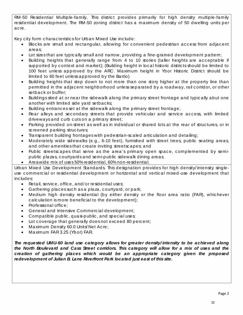
Page 2
RM-50 Residential Multiple-family. This district provides primarily for high density multiple-family residential development. The RM-50 zoning district has a maximum density of 50 dwelling units per acre. Key city form characteristics for Urban Mixed Use include:
Blocks are small and rectangular, allowing for convenient pedestrian access from adjacent areas;
Lot sizes that are typically small and narrow, providing a fine-grained development pattern; Building heights that generally range from 4 to 10 stories (taller heights are acceptable if
supported by context and market); (Building height in local historic districts should be limited to 100 feet unless approved by the ARC. Maximum height in Ybor Historic District should be limited to 60 feet unless approved by the Barrio)
Building heights that step down to not more than one story higher at the property line than permitted in the adjacent neighborhood unless separated by a roadway, rail corridor, or other setback or buffer;
Buildings sited at or near the sidewalk along the primary street frontage and typically abut one another with limited side yard setbacks;
Building entrances set at the sidewalk along the primary street frontage; Rear alleys and secondary streets that provide vehicular and service access, with limited
driveways and curb cuts on a primary street; Parking provided on-street as well as in individual or shared lots at the rear of structures, or in
screened parking structures; Transparent building frontages with pedestrian-scaled articulation and detailing; Moderately wide sidewalks (e.g., 6-10 feet), furnished with street trees, public seating areas,
and other amenities that create inviting streetscapes; and Public streetscapes that serve as the area’s primary open space, complemented by semi-
public plazas, courtyards and semi-public sidewalk dining areas. Areawide mix of uses 50% residential, 60% non-residential.
Urban Mixed Use Development Standards. This designation provides for high density/intensity single-use commercial or residential development or horizontal and vertical mixed-use development that includes:
Retail, service, office, and/or residential uses; Gathering places such as a plaza, courtyard, or park; Medium high density residential (by either density or the floor area ratio (FAR), whichever
calculation is more beneficial to the development); Professional office; General and Intensive Commercial development; Compatible public, quasi-public, and special uses; Lot coverage that generally does not exceed 80 percent; Maximum Density 60.0 Units/Net Acre; Maximum FAR 3.25 (Ybor) FAR.
The requested UMU-60 land use category allows for greater density/intensity to be achieved along the North Boulevard and Cass Street corridors. This category will allow for a mix of uses and the creation of gathering places which would be an appropriate category given the proposed redevelopment of Julian B. Lane Riverfront Park located just east of this site. C
32
Page 3
COMPREHENSIVE PLAN OBJECTIVES AND POLICIES Livable City Goals, Objectives and Policies Policy 18.6.1: Encourage the development of commercial uses in character and/or scale with
the general look and scale of the community and in context with its culture and history. This site is located in the West Tampa Urban Village and the Central Tampa Planning District. The requested land use categories of CMU-35, NMU-35 and UMU-60 allows for placement of the higher density/intensity UMU-60 along the North Boulevard and Cass Street corridors. The land use categories of NMU-35 and CMU-35 allow for lower intensity development and create a more appropriate transition to the existing residential uses to the west.
URBAN VILLAGE GOALS, OBJECTIVES AND POLICIES Goal 18: Every neighborhood will be a desirable place to live.
Policy 18.1.5: Relate new buildings to the context of the neighborhood and community.
The area contained within this request is immediately adjacent to single family residential uses to the west across North Gilchrist Avenue. The parcels located south of West Cass Street and north of West Carmen Street are immediately adjacent to commercial uses. The areas under this request contain current land use designations of R-20, R-35, and GMU-24. Given the depths of the blocks contained in this request, the UMU-60 category is requested along the North Boulevard and Cass Street corridors. The CMU-35 and NMU-35 categories are requested to the west to create a transition to the existing single family residential uses. This request creates an appropriate transition into the neighborhood and will allow for buildings in context with the surrounding community.
Objective 18.2:
Locate higher density housing in or near the downtown core and medium density bicycle and transit trips.
Policy 18.2.5: Ensure that new growth areas include neighborhoods that maintain a mix of residential types and densities, and that the residential mix will provide appropriate transitional features that integrate the area with adjacent existing neighborhoods and development.
Policy 18.3.2: Consider the impacts of (re) development projects on the existing, physical and social framework and character of the affected area should be recognized and discussed during the development review process.
The area contained within this request is surrounded with R-20 and R-35 land use designations to the west, GMU-24 along and south of West Cass Street, and RMU-100 to the east. While the Planning staff finds a mixed use category is appropriate in this location, a mixed use category with a lower scale FAR such as the 2.0 FAR allowed in the CMU-35 land use category would create a more appropriate transition to the surrounding residential neighborhoods and development. This request, if approved, will create an appropriate transition to the neighborhood to the west.
33
Page 4
REVIEW CRITERIA FOR PLAN AMENDMENT REQUESTS City Council must consider the following criteria as set forth in the City of Tampa Comprehensive Plan when deciding the request for a Comprehensive Plan Amendment; both staff’s professional opinion and factual information is provided in bold below: 1. The requested land use category meets the intent of the general character description of the City
Form component in which it is being requested and is otherwise consistent with the Comprehensive Plan.
What is Tampa’s specific ‘City Form’? (Chapter 3, Pages 49 – 50) Tampa’s form is and will continue to be shaped by historical development patterns. The City has developed over the span of 150 years, and is influenced by the building patterns that occurred during three significant periods of time as described below.
In general, Tampa has developed and redeveloped as an urban city, with a defined urban core, regional and community centers, and established residential neighborhoods. As an urban city, Tampa has a defined city form that encompasses many components, such as business centers, urban villages, mixed-use corridor villages, transit stations and neighborhoods.
The growth management strategy established in this Plan focuses on establishing sustainable and livable environments in areas with diverse needs. This will require sustained efforts to improve the mix of land uses. The sustainability and livability of Tampa’s city form relating to future growth and further redevelopment relies heavily on the natural evolution of all of the city form components, coupled with survival and protection of the established residential neighborhoods. This site is located within the West Tampa Urban Village and is predominately surrounded with single and multiple family residential to the west and public uses to the east across North Boulevard. The requested UMU-60 land use category will allow for a much greater increase in density/intensity, allowing for building heights ranging up to ten (10) stories. Based upon the existing character of the surrounding residential uses which vary from one (1) to two (2) story single family residential to four (4) story multi-family residential located further west along West Cypress Street, staff finds this companion request will allow for an appropriate transition, should Council decide to approve CPA 16-03A.
2. In approving any request for a land use category that provides for an increase in density, intensity
or for a broader range of uses, than the existing land use category, City Council shall determine whether: a. a land use category of similar density or intensity is located on at least one (1) side of the
subject site, and The closest site has an RMU-100 (similar to the UMU-60) land use category and is located on the east side of North Boulevard. This site contains a private school use.
b. the subject site is within 1320’ (1/4 mile) of a designated transit station or designated transit
corridor, and There is not a designated transit station or designated transit corridor with ¼ mile of this site.
c. if the subject parcel is located adjacent to a parcel which has a land use classification of R-6
or R-10, the subject site is located within 660’ (1/8 mile) of a designated transit station or designated transit corridor. N/A
3. In the event that City Council determines that the above criteria are not met, then City Council
may deny the amendment or make a determination that the existing land use classification is no
34
Page 5
longer in the best interests of the public. In this event, then City Council may approve the amendment or direct the local planning agency to propose an alternative amendment to the existing land use classification. The requested CMU-35 and NMU-35 land use categories will create an appropriate transition given the development potential under this designation. These categories will achieve lower intensities than the requested UMU-60 and are requested in locations to allow for transitions to existing lower density/intensity uses. City Planning staff finds this companion amendment will create an appropriate transition between the commercial corridor of North Boulevard and the existing residential uses which exists to the west of this site. Staff finds the requested UMU-60 in CPA 16-03A will be consistent only in conjunction with this companion amendment request.
4. If a land use is changed based on this criteria, the property owner shall process through a site
plan district and, if provided for in the City’s land development regulations, shall meet the “Development Performance Incentive Criteria,” unless the development is within an approved Community Planning Area/Adopted Form Based Code Area, in which case a site plan zoning may not be required, as provided for in the specific plan in the land development regulations. Acknowledged.
35

This Page Intentionally Left Blank
36
Attachment C
Site Photos
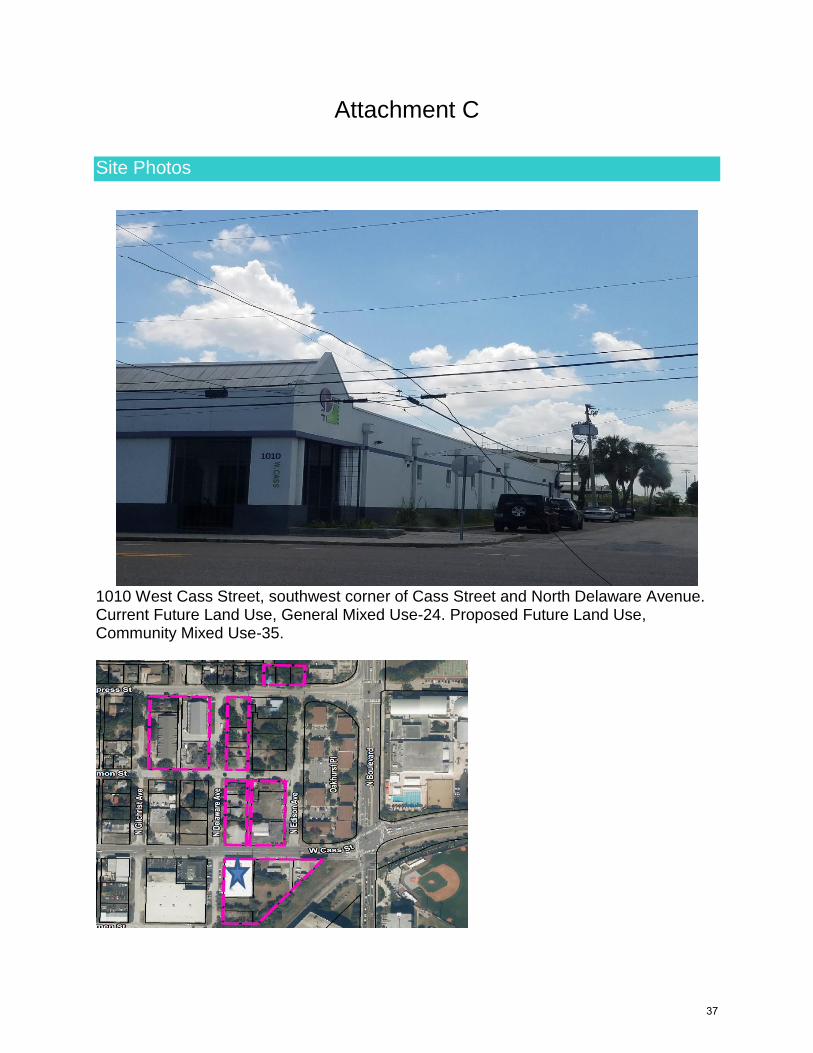
1010 West Cass Street, southwest corner of Cass Street and North Delaware Avenue. Current Future Land Use, General Mixed Use-24. Proposed Future Land Use, Community Mixed Use-35.
37
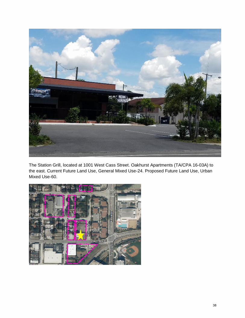
The Station Grill, located at 1001 West Cass Street. Oakhurst Apartments (TA/CPA 16-03A) to
the east. Current Future Land Use, General Mixed Use-24. Proposed Future Land Use, Urban
Mixed Use-60.
38
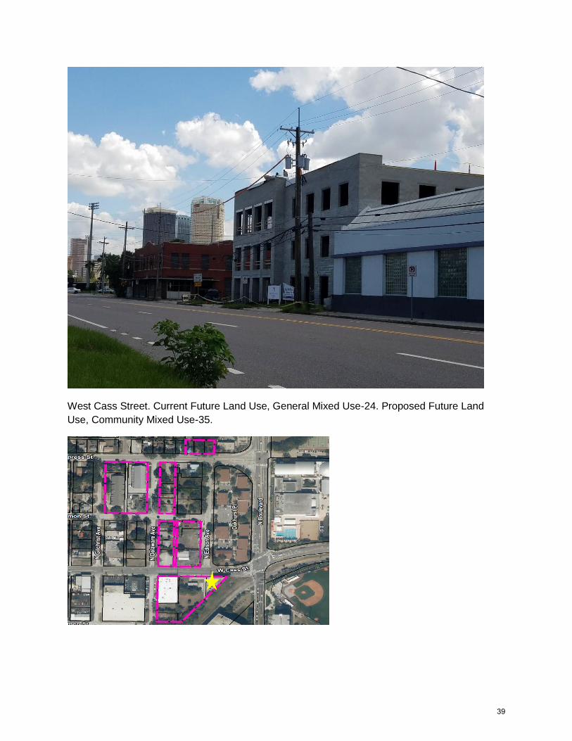
West Cass Street. Current Future Land Use, General Mixed Use-24. Proposed Future Land
Use, Community Mixed Use-35.
39
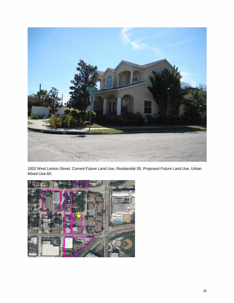
1002 West Lemon Street. Current Future Land Use, Residential-35. Proposed Future Land Use, Urban
Mixed Use-60.
40
1010 West Lemon Street. Current Future Land Use, Residential-35. Proposed Future Land Use,
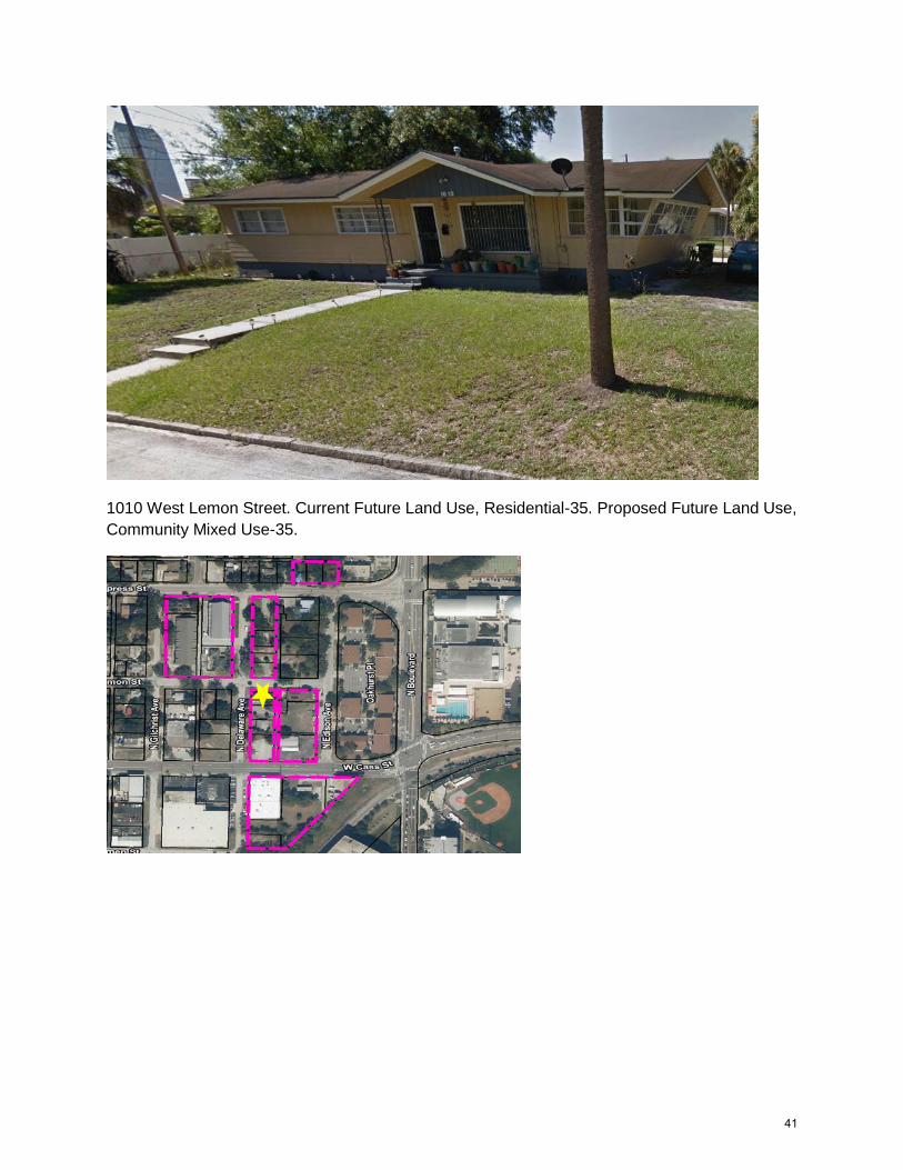
Community Mixed Use-35.
41
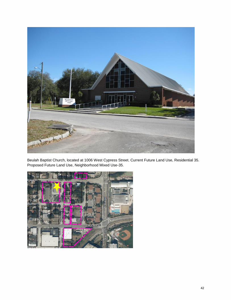
Beulah Baptist Church, located at 1006 West Cypress Street. Current Future Land Use, Residential 35.
Proposed Future Land Use, Neighborhood Mixed Use-35.
42
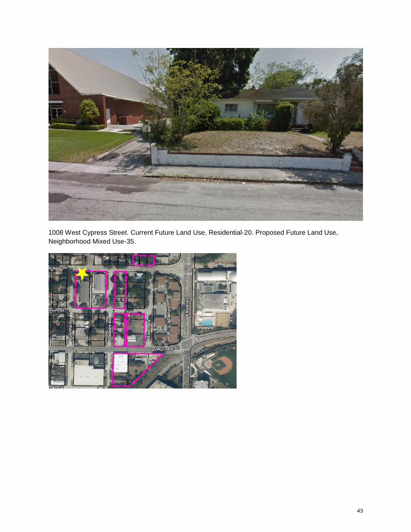
1008 West Cypress Street. Current Future Land Use, Residential-20. Proposed Future Land Use,
Neighborhood Mixed Use-35.
43
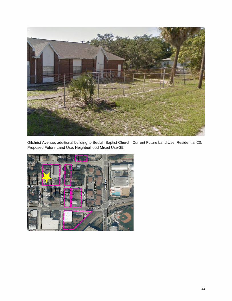
Gilchrist Avenue, additional building to Beulah Baptist Church. Current Future Land Use, Residential-20.
Proposed Future Land Use, Neighborhood Mixed Use-35.
44