Embed Size (px)
Citation preview
TASK 2. ANADROMOUS ADULT AND SMOLT MONITORING WITH DIDSON CAMERA IN TOPANGA CREEK
SANTA MONICA BAY ANADROMOUS ADULT AND JUVENILE
STEELHEAD MONITORING 2013-2018
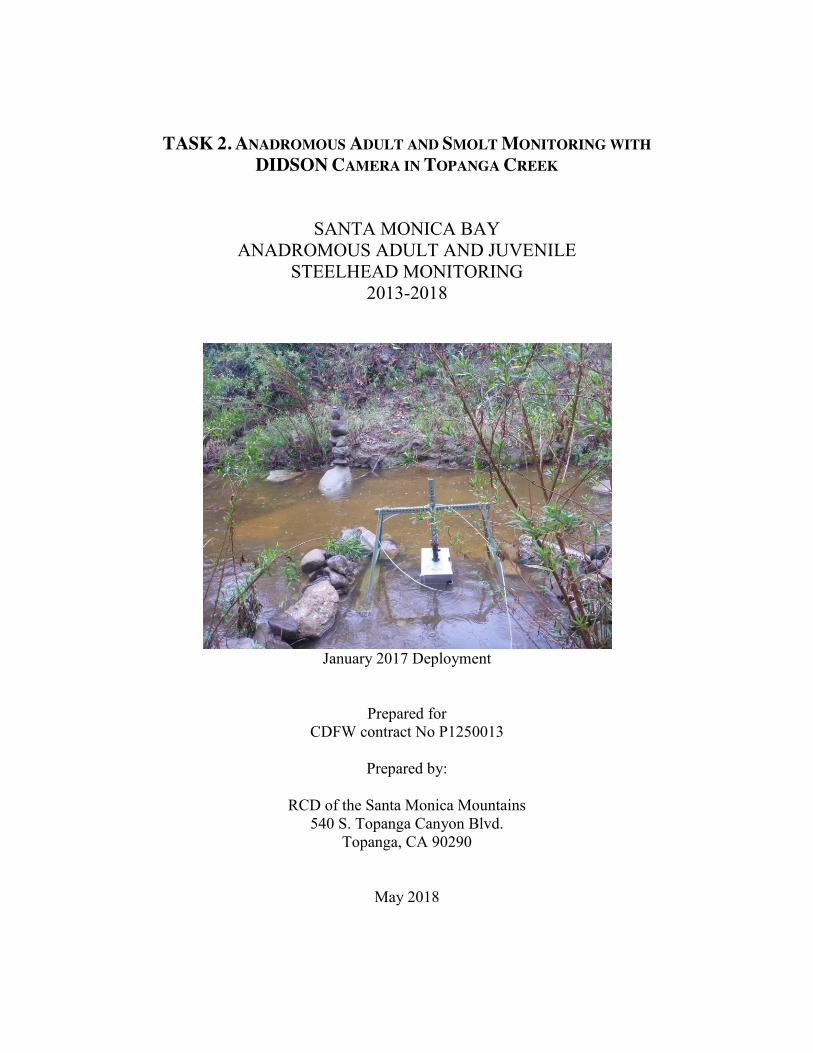
January 2017 Deployment
Prepared for CDFW contract No P1250013
Prepared by:
RCD of the Santa Monica Mountains
540 S. Topanga Canyon Blvd. Topanga, CA 90290
May 2018
TASK 2. Anadromous Adult and Smolt Monitoring with DIDSON camera SMB Steelhead Monitoring 2013-2018
2-2
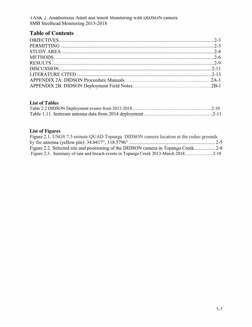
Table of Contents OBJECTIVES ............................................................................................................................. 2-3 PERMITTING ............................................................................................................................ 2-3 STUDY AREA ........................................................................................................................... 2-4 METHODS ................................................................................................................................. 2-6 RESULTS ................................................................................................................................... 2-9 DISCUSSION ........................................................................................................................... 2-11 LITERATURE CITED ............................................................................................................. 2-13 APPENDIX 2A: DIDSON Proceedure Manuals………………………………..…………….…..................2A-1 APPENDIX 2B: DIDSON Deployment Field Notes……………………………………….………............2B-1 List of Tables Table 2.2 DIDSON Deployment events from 2012-2018……………………………………………..2-10 Table 1.11. Instream antenna data from 2014 deployment……………………………………2-11 List of Figures Figure 2.1. USGS 7.5-minute QUAD Topanga DIDSON camera location at the rodeo grounds by the antenna (yellow pin): 34.0417°, 118.5796° ...................................................................... 2-5 Figure 2.2. Selected site and positioning of the DIDSON camera in Topanga Creek ................. 2-8 Figure 2.3. Summary of rain and breach events in Topanga Creek 2013-March 2018……………….2-10
TASK 2. Anadromous Adult and Smolt Monitoring with DIDSON camera SMB Steelhead Monitoring 2013-2018
2-3
OBJECTIVES To augment the current Topanga Creek Life Cycle Monitoring program, a DIDSON camera was deployed in Topanga Creek State Park, just upstream of the upper end of Topanga Lagoon, in accordance with recommendations by NMFS Southern Steelhead Trout Recovery Program research priorities and the priorities and methods outlined in the CA Coastal Salmonid Population Monitoring Strategy, Design and Methods (Adams et al. 2011). The DIDSON camera was intended to be utilized to capture anadromous adults and smolts migrating during high flow events when traps could not be deployed, thereby expanding the ability to effectively monitor the full extent of the migration period. Although an instream antenna array was also functional during the study period (2013-2018), it was only capable of documenting the passage of tagged individuals. Tagging of O. mykiss was initiated in Topanga Creek in 2008 and 1,674 individuals have been tagged to date. Aside from individuals tagged by Kelley (2008) in the Santa Clara River, anadromous adults coming upstream from other source creeks are unlikely to be tagged, and thus unidentifiable by the instream antenna array alone. Deployment of the DIDSON camera in conjunction with the instream antenna array provided the capacity to capture all individuals whether tagged or not, the ability to identify tagged verses untagged individuals, and provide a more accurate count of anadromous adults entering and smolts leaving Topanga Creek. Utilizing these tools in conjunction also provides an opportunity to compare the effectiveness of different methods under varying conditions of flow, turbidity, etc. The relationship between smolt size and probability of return from the ocean suggests that larger smolts have a higher survival rate (Bond et al. 2008). Identifying the suite of environmental factors within the mainstem of small coastal creeks that foster rapid juvenile growth has been identified as a high research priority (NMFS 2012). Another priority is to ascertain what encourages successful anadromy. The addition of the DIDSON camera to the on-going Lifecycle Monitoring in Topanga Creek afforded the opportunity to determine size of migrating individuals, to obtain a more accurate count, and to provide data for addressing the following research questions posed by NMFS (2012):
� the relationship between reliability of migration corridors and anadromous faction, � the spawner density (at spatial and temporal scales) necessary to indicate a viable
population of steelhead, � the mechanism for, and frequency of, life-history crossovers in the southern CA region
and the effect crossovers have on persistence of the anadromous form, and � whether fast growth and good conditions in freshwater encourage a more resident
population, or conversely, whether such conditions set the stage for successful marine survival when out-migration is possible.
PERMITTING Right of Entry and CDPR Scientific Collecting permits for deploying the DIDSON camera in lower Topanga Creek State Park were obtained in 2012 (and have been renewed until 2020). No other permits were needed to seasonally deploy the portable 10 foot Mobile Mini office in the dirt parking area of the former Rodeo Grounds Road. During deployment, the camera was sited
TASK 2. Anadromous Adult and Smolt Monitoring with DIDSON camera SMB Steelhead Monitoring 2013-2018
2-4
in such a way as to avoid any erosion or channel impacts, even during high flows, therefore avoiding the need for a Streambed Alteration Agreement.
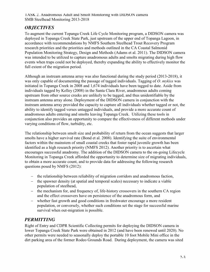
STUDY AREA Topanga Creek Watershed is the third largest in the Santa Monica Bay at 18 square miles. The natural limit of anadromy is located approximately four miles upstream from the ocean. Ownership in the Topanga Creek Watershed is 70% state park, 2% federal parkland, 26% private, and 2% local parks. Existing development includes two residential sub-divisions, a mobile home park, three commercial areas (under 20 acres each), and residential development located in historic small lot sub-divisions or on private lots. Most parcels in Topanga are under 40 acres and regulated by Hillside Management Criteria, the Santa Monica Mountains North Area Plan, and the Santa Monica Mountains Local Coastal Plan, all of which restrict development density. The creek is accessible from numerous locations along the road shoulder of Topanga Canyon Blvd. The DIDSON site is accessed from the old Rodeo Grounds Road, which is approximately 500m north of Pacific Coast Highway at Topanga Canyon Boulevard in Malibu, CA (Figure 2.1). The deployment location of the DIDSON camera was approximately 600 meters upstream from the ocean, and approximately 25 meters upstream of the instream antenna location. The weir trap deployment site was an additional 1000 meters upstream.
TASK 2. Anadromous Adult and Smolt Monitoring with DIDSON camera SMB Steelhead Monitoring 2013-2018
2-5
Figure 2.1. USGS 7.5-minute QUAD Topanga
DIDSON camera location at the Rodeo Grounds by the antenna (green star): 34.0417°, 118.5796° Ocean/creek mouth: 34.0403°, 118.5806°
TASK 2. Anadromous Adult and Smolt Monitoring with DIDSON camera SMB Steelhead Monitoring 2013-2018
2-6
METHODS
Equipment A temporary secure 8ft x 10ft mobile office trailer (Mobile Mini) was rented and placed on site between November and May each year to provide a safe and dry place to work and to house the computers and all ancillary equipment. The Mobile Mini was set up next to a utility pole with a breaker box from which electricity was accessed. A portable electrical connection was used to prevent vandalism. A Verizon mobile hotspot was also activated to provide internet access to the analysis laptop. For the first two deployments (April 2012 and January 2013), CDFW’s mobile solar trailer was used to power the DIDSON. The majority of equipment needed for DIDSON deployment was provided by CDFW, with additional equipment purchased as needed. The primary components included:
1. DIDSON Pelican Case with DIDSON camera, topside box, topside box power cable, Ethernet cable, and bolts,
2. Silt box and metal debris box with a metal plate for attaching to the camera, a ball mount to connect to the A-frame, and a lock for keeping debris box closed and protected from vandalism,
3. 500 foot DIDSON cable with spool 4. A-frame mount with 3 locking pins and ball joint, 5. Two laptop computers with power cords, 6. Two external memory devices, and 7. 7/16 wrench and a flat head screw driver.
Additional equipment included water quality testing probes (for recording pH, conductivity, DO, water and air temperature), turbidity meter, rite in the rain notebook, data sheets, pencils, cameras with chargers, two-way radios, tether cord, waders, life vests, waterproof flashlights, sand bags, zip ties, shovels, rebar, loppers, towels, and rain gear. Refer to Appendix 2 for further equipment information.
Training Training was conducted for all RCDSMM, CDFW field staff, and RCDSMM Stream Team volunteers who would be assisting in the operation and maintenance of the equipment. Annual training sessions were coordinated by Rosi Dagit of the RCDSMM and led by DIDSON specialists from CDFW Santa Barbara office. Training events took place in November 2013, December 2013, June 2014 (Malibu), November 2014, and December 2015, 2016 and 2017.
Deployment of DIDSON camera Timing Due to the flashy nature of the Topanga Creek hydrograph, the DIDSON camera could only be deployed during significant storm events occurring within the typical rainy season (November through May) of 2012, 2013, and 2014. Due to the on-going drought, it was not possible to deploy the camera at all in 2015 and 2018, and only once in 2016. With the return of the rains in 2017, four deployments were possible. Multiple conditions need to be present in order to prompt
TASK 2. Anadromous Adult and Smolt Monitoring with DIDSON camera SMB Steelhead Monitoring 2013-2018
2-7
deployment:
1) A storm forecasted to produce enough rainfall and flow to allow for proper use of the DIDSON camera arrived,
2) Topanga Lagoon was connected and passable at high tide, 3) Water levels in the creek were at least 40 cm deep at the deployment location and
holding steady two hours prior to expected deployment. 4) Topanga Creek was connected upstream to at least 3.6 rkm.
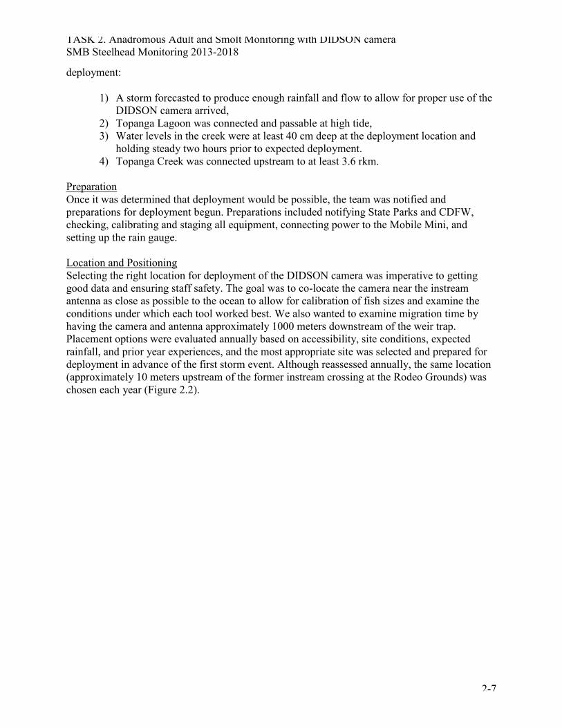
Preparation Once it was determined that deployment would be possible, the team was notified and preparations for deployment begun. Preparations included notifying State Parks and CDFW, checking, calibrating and staging all equipment, connecting power to the Mobile Mini, and setting up the rain gauge. Location and Positioning Selecting the right location for deployment of the DIDSON camera was imperative to getting good data and ensuring staff safety. The goal was to co-locate the camera near the instream antenna as close as possible to the ocean to allow for calibration of fish sizes and examine the conditions under which each tool worked best. We also wanted to examine migration time by having the camera and antenna approximately 1000 meters downstream of the weir trap. Placement options were evaluated annually based on accessibility, site conditions, expected rainfall, and prior year experiences, and the most appropriate site was selected and prepared for deployment in advance of the first storm event. Although reassessed annually, the same location (approximately 10 meters upstream of the former instream crossing at the Rodeo Grounds) was chosen each year (Figure 2.2).
TASK 2. Anadromous Adult and Smolt Monitoring with DIDSON camera SMB Steelhead Monitoring 2013-2018
2-8
Figure 2.2. Selected site and positioning of the DIDSON camera in Topanga Creek
One of the main considerations for the chosen site was substrate. Since the substrate needs to be fairly smooth to avoid turbulence around cobbles and boulders that obscure the image, we utilized a section of the creek where an old concrete slab remained from a former road crossing. Stream banks were another important consideration for placement. Positioning the camera in the creek so that the device was secure and accessible during increasing flows and as the channel width and depth expanded was critical. The gently sloping bank on the camera side of the selected site allowed us to more easily move the camera as flows increased and at the same time provided safe passage for staff to move along the bank during peak flow. Sandbags, cobbles, and boulders were used to both secure the A-frame in place and create deflection barriers to prevent fish from swimming behind the camera as water level increased. Deployment Procedure The first step of deployment included measuring wetted width and flow, installing flagged rebar at the water edge to mark changes in stream width over time, collecting water quality data, and collecting and processing turbidity samples. This was followed by moving equipment to the creek, setting up the A-frame, attaching and positioning the camera, connecting the cables, and initializing the software as per CDFW instructions (Appendix 2A).
TASK 2. Anadromous Adult and Smolt Monitoring with DIDSON camera SMB Steelhead Monitoring 2013-2018
2-9
End of Deployment Deployment ended once water levels had dropped to the point that the camera was no longer submerged. At the end of deployment, all equipment was moved up from the creek to be checked, cleaned, dried and stored in the Mobile Mini office until the next deployment.
Monitoring of equipment For safety and data quality considerations, a minimum of two people were on site at all times that the camera was deployed. The camera imagery was continually monitored on the laptop, and field checks of the camera itself were performed hourly or more frequently if needed. Camera location, window length, focus, and angle of the sonar unit were adjusted as stream conditions changed. In addition to monitoring the camera and processing video, the onsite staff took hourly measurements of turbidity, water and air temperatures, total rainfall, flow, and wetted width of the channel at the camera location. They also tracked the storm activity online, checked tides, monitored the lagoon, and checked the weir trap and instream antenna.
Data analysis The collected data was analyzed using the Echogram feature of the DIDSON Sondmetrics topside software. The Echogram function maps out data on a time verses range graphic, allowing easy determination of objects changing in range over time. Echograms with and without motion detection enabled were used as a tool for identifying where potential fish movement occurred in the data set. When a mark was seen on the echogram that resembled fish movement, the raw footage for that time period was then reviewed for species verification, direction and size measurements. Fish were measured using the Box measuring method (Pipal et al. 2010). All fish observations were recorded on hard copy data sheets and an excel file, and then compared with instream antenna, mark-recapture, and trap data. Data review and processing were done daily by staff working in the mobile mini office and overseeing camera function and security, and then sent to Pacific States Marine Fisheries Commission technicians for a second pass.
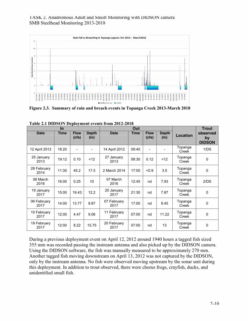
RESULTS In the study period (2013-2018), it was only possible to deploy the DIDSON camera was deployed on seven occasions at the Topanga Creek Rodeo Grounds site (2013-2018) and once in Malibu Lagoon (June 2014) to test and see if it was possible to find O. mykiss in the larger area. No O. mykiss were observed in Malibu by the DIDSON. It was otherwise too dry with insufficient flow in the creek and lack of connectivity to the ocean to warrant deployment (Table 2.1). During these seven events, three O. mykiss were captured by the sonar device (Table 2.2). The 2012 deployment was completed prior to the start of this study, but is included for completeness.
TASK 2. Anadromous Adult and Smolt Monitoring with DIDSON camera SMB Steelhead Monitoring 2013-2018
2-10
Figure 2.3. Summary of rain and breach events in Topanga Creek 2013-March 2018 Table 2.1 DIDSON Deployment events from 2012-2018
In Out Location
Trout observed
by DIDSON
Date Time Flow (cfs)
Depth (in)
Date Time Flow (cfs)
Depth (in)
12 April 2012 18:20 - - 14 April 2012 09:40 - - Topanga Creek 1/DS
25 January 2013 19:12 0.10 <12 27 January
2013 08:30 0.12 <12 Topanga Creek 0
28 February 2014 11:30 45.2 17.5 2 March 2014 17:00 <0.9 3.5 Topanga
Creek 0
06 March 2016 16:00 0.25 10 07 March
2016 12:45 nd 7.93 Topanga Creek 2/DS
19 January 2017 15:00 19.43 12.2 20 January
2017 21:30 nd 7.87 Topanga Creek 0
06 February 2017 14:00 13.77 9.87 07 February
2017 17:00 nd 9.45 Topanga Creek 0
10 February 2017 12:00 4.47 9.06 11 February
2017 07:00 nd 11.22 Topanga Creek 0
19 February 2017 12:00 8.22 15.75 20 February
2017 07:00 nd 13 Topanga Creek 0
During a previous deployment event on April 12, 2012 around 1940 hours a tagged fish sized 355 mm was recorded passing the instream antenna and also picked up by the DIDSON camera. Using the DIDSON software, the fish was manually measured to be approximately 270 mm. Another tagged fish moving downstream on April 13, 2012 was not captured by the DIDSON, only by the instream antenna. No fish were observed moving upstream by the sonar unit during this deployment. In addition to trout observed, there were chorus frogs, crayfish, ducks, and unidentified small fish.
TASK 2. Anadromous Adult and Smolt Monitoring with DIDSON camera SMB Steelhead Monitoring 2013-2018
2-11
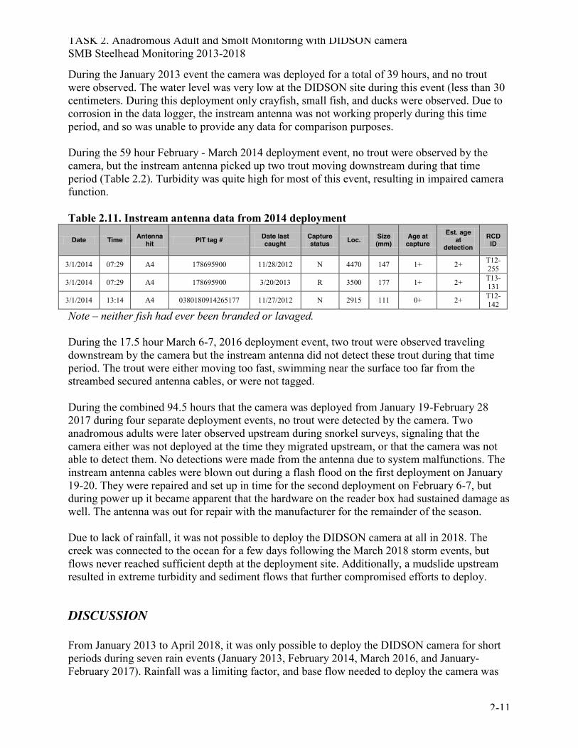
During the January 2013 event the camera was deployed for a total of 39 hours, and no trout were observed. The water level was very low at the DIDSON site during this event (less than 30 centimeters. During this deployment only crayfish, small fish, and ducks were observed. Due to corrosion in the data logger, the instream antenna was not working properly during this time period, and so was unable to provide any data for comparison purposes. During the 59 hour February - March 2014 deployment event, no trout were observed by the camera, but the instream antenna picked up two trout moving downstream during that time period (Table 2.2). Turbidity was quite high for most of this event, resulting in impaired camera function. Table 2.11. Instream antenna data from 2014 deployment
Date Time Antenna hit PIT tag # Date last
caught Capture status Loc. Size
(mm) Age at
capture Est. age
at detection
RCD ID
3/1/2014 07:29 A4 178695900 11/28/2012 N 4470 147 1+ 2+ T12-255
3/1/2014 07:29 A4 178695900 3/20/2013 R 3500 177 1+ 2+ T13-131
3/1/2014 13:14 A4 0380180914265177 11/27/2012 N 2915 111 0+ 2+ T12-142
Note – neither fish had ever been branded or lavaged. During the 17.5 hour March 6-7, 2016 deployment event, two trout were observed traveling downstream by the camera but the instream antenna did not detect these trout during that time period. The trout were either moving too fast, swimming near the surface too far from the streambed secured antenna cables, or were not tagged. During the combined 94.5 hours that the camera was deployed from January 19-February 28 2017 during four separate deployment events, no trout were detected by the camera. Two anadromous adults were later observed upstream during snorkel surveys, signaling that the camera either was not deployed at the time they migrated upstream, or that the camera was not able to detect them. No detections were made from the antenna due to system malfunctions. The instream antenna cables were blown out during a flash flood on the first deployment on January 19-20. They were repaired and set up in time for the second deployment on February 6-7, but during power up it became apparent that the hardware on the reader box had sustained damage as well. The antenna was out for repair with the manufacturer for the remainder of the season. Due to lack of rainfall, it was not possible to deploy the DIDSON camera at all in 2018. The creek was connected to the ocean for a few days following the March 2018 storm events, but flows never reached sufficient depth at the deployment site. Additionally, a mudslide upstream resulted in extreme turbidity and sediment flows that further compromised efforts to deploy.
DISCUSSION From January 2013 to April 2018, it was only possible to deploy the DIDSON camera for short periods during seven rain events (January 2013, February 2014, March 2016, and January-February 2017). Rainfall was a limiting factor, and base flow needed to deploy the camera was
TASK 2. Anadromous Adult and Smolt Monitoring with DIDSON camera SMB Steelhead Monitoring 2013-2018
2-12
extremely ephemeral. During this period two anadromous adults were documented migrating into Topanga Creek in winter 2017 but were not detected by the camera or instream antenna, and only two out-migrating smolts were documented by the sonar camera (March 2016). An additional out-migrating smolt was documented prior to this study period, in an experimental deployment in April 2012. Due to such limited opportunities to deploy the device, there is yet insufficient data to effectively address the proposed research questions comparing efficiency between different detection tools (antenna vs. weir trap vs. DIDSON). The few O. mykiss observations by the DIDSON camera 2013-2018 can be attributed to low flows and insufficient depth associated with the drought. High turbidity levels (maximum = 1295 NTU, average = 180 NTU) were found to impair camera function in 2014 as compared to the instream antenna, which detected two confirmed out-migrating smolts that the camera missed. With only two observations by the DIDSON camera and two by the instream antenna, it is not yet possible to compare DIDSON detections to instream antenna detections. It was also not possible to deploy the weir trap during the study period, so we are unable to analyze trapping efficiency, detection of tagged individuals, and detection of untagged individuals. Nor is it possible to estimate fish movement patterns, such as duration of travel between the camera and antenna or traps located upstream, numbers and size entering or leaving the system, timing of movement, and flows associated with movement of both anadromous adults and smolts. However, this data does suggest that drought coupled with low abundance of O. mykiss overall results in minimal detectable migration. Throughout the Southern California Coast DPS the lack of detections suggests that the few sightings in Topanga Creek are consistent with the few sightings at other sites in the Santa Ynez or Ventura Rivers, which shared the same impacts from the drought. In 2013 a total of six and in 2014 a total of five observations of anadromous adults were observed throughout the DPS (CDFW unpublished data). There were no sightings of anadromous adults by DIDSON, however two adults were observed in 2015. There was only one anadromous individual seen in 2016, and tent in 2017, with five of those found in the Santa Monica Bay (CDFW and RCDSMM unpublished data). Two entered Arroyo Sequit following the January storms, one adult female died in Malibu Creek in March 2017, and two others over-summered in Topanga Creek, with one adult female dying in September 2017.We do not know the fate of the other steelhead from Topanga but it was not observed after the summer. One of the adults in Arroyo was found dead in September and the other one was re-located from Arroyo to Topanga in November due to pool drying down. A single anadromous adult was captured in San Juan Creek in 2018 (NMFS unpublished data). While it was also anticipated that DIDSON data would be useful for examining effectiveness of restoration efforts in lower Topanga Creek, there has not been enough consistent flow in the steam channel to allow for a full evaluation of stream connectivity and function. The few sightings suggest an extremely low baseline steelhead population. The need for continued monitoring is key to understanding recovery after the future restoration of Topanga Lagoon, or other lagoon systems.
TASK 2. Anadromous Adult and Smolt Monitoring with DIDSON camera SMB Steelhead Monitoring 2013-2018
2-13
Even with the additional flows during 2017, the data available thus far suggests that the low abundance combined with drought-limited fish passage opportunities makes it challenging to address research questions posed by NMFS (2012) regarding the relationship between reliability of migration corridors (minimal during drought), the spawner density (extremely low abundance) necessary to indicate a viable population of steelhead, the mechanism for and effect of life-history crossovers, or whether fast growth and good conditions in freshwater encourage a more resident population. It appears that at this time the combination of drought restricted access to freshwater spawning systems coupled with the extremely low numbers of anadromous adults is cause for extreme concern. Additional analysis of drought impacts indicated a significant correlation between rainfall and relative abundance associated with the lack of anadromous spawners and few redds (Dagit et al. 2017).
LITERATURE CITED Adams, P. B., Boydstun, L. B., Gallagher, S. P., Lacy, M. K., McDonald, T., & Shaffer, K. E. 2011. California coastal salmonid population monitoring: strategy, design, and methods. Fish Bulletin, 180. Bond, M.H., S.A. Hayes, C.V. Hanson, and R.B. MacFarlane. 2008. Marine survival of steelhead (Oncorhynchus mykiss) enhanced by a seasonally closed estuary. Canadian Journal of Fisheries and Aquatic Sciences 65: 2242-2252. Dagit, R., E. Bell, K. Adamek, J. Mongolo, E. Montgomery, N. Trusso, and P. Baker. 2017. The effects of a prolonged drought on southern Steelhead Trout (Oncorhynchus mykiss) in a coastal creek, Los Angeles County, California. Bulletin of the Southern California Academy of Sciences Vol 116(3):162-173 Kelley, E. 2008. Steelhead Smolt Survival in the Santa Clara and Santa Ynez River Estuaries. Prepared for The California Department of Fish and Game. University of California, Santa Barbara. August 2008. 61 pp. NMFS (National Marine Fisheries Service). 2012. Southern California Steelhead Recovery Plan. Southwest Regional Office, Protected Resources Division, National Marine Fisheries Service, Long Beach, California, USA. Pipal, K., M. Jessop, D. Boughton, and P. Adams. 2010. Using DUAL-FREQUENCY IDENTIFICATION SONAR (DIDSON) to estimate adult steelhead escapement in the And Lorenzo River, California California Fish and Game Bulletin, 96(1): 90-95.
Appendix 2A
DIDSON Procedure Manuals
TASK 2. ANADROMOUS ADULT AND SMOLT MONITORING WITH DIDSON CAMERA IN TOPANGA CREEK
SANTA MONICA BAY ANADROMOUS ADULT AND JUVENILE
STEELHEAD MONITORING 2015-2018
Prepared for CDFW contract No P1250013
Prepared by:
RCD of the Santa Monica Mountains 540 S. Topanga Canyon Blvd.
Topanga, CA 90290
May 2018

TASK 2. Appendix 2A - DIDSON Procedures Manuals
2A-1
RCDSMM DIDSON Deployment Protocol 2014-2018
The purpose of this protocol is to guide the installation and deployment of a DIDSON camera in Topanga Creek. Some of the steps will vary depending on flow regime and rainfall rates, and can be adjusted accordingly. Project Contacts and Phone Numbers: Contact one of the following people if there are questions or concerns: Rosi Dagit, RCD Project Manager (Cell) – 310-488-6381 Rosi Dagit (Home Office) – 310-455-7528 Sam Bankston, CDFW – 805-423-5477 RCD Office (Topanga) – 818-597-8627 ext. 102 (John Hendra) Marcel Bourget (electrician) – 310-488-5361 Sandra Albers 909.262.4618 Krista Adamek 951.312.6785 Steve Williams 310.699.1489 Lizzy Montgomery 715.212.7679 Andre Sanchez 559.474.0225 Mary Larson 562.537.8624 Dana McCanne 805.962.4841 Kate McLaughlin 805.962.4475 c Danielle Yaconelli 562.666.5695 c 805.288.3519o STATE PARKS – Dispatch – 951.443.2969 Suzanne Goode 310.699.1720c 818.880.0364 o Stephen Bylin 310.562.1669 Jamie King 310.699.3951c 818.880.0674 o I. Prior to deployment – when to deploy When a storm is approaching, the current depth and flow of the creek should be noted and the storm should be tracked using NOAA and other weather tracking sites. Suggested websites for storm tracking:
x NOAA Weather (also see Forecast Discussion for details) - http://forecast.weather.gov/MapClick.php?site=lox&textField1=34.09361&textField2=-118.60056
x The Weather Channel Satellite Video – http://www.weather.com/maps/geography/westus/westcoastussatellite_large.html
x LA County DPW WRD (for approximate rainfall totals) - http://www.ladpw.org/wrd/precip/
When it appears like the storm will produce enough rainfall and flow to allow for proper use of DIDSON and/or traps, preparation for deployment should begin.
TASK 2. Appendix 2A - DIDSON Procedures Manuals
2A-2
Water levels in the creek should be monitored closely as well when expecting a storm – check Topanga Bridge (mm 2.02), Fish Camp, DIDSON site, and Lagoon for connectedness. Lagoon needs to be connected and passable at high tide. Water levels need to be at least 20 inches and holding steady by noon before getting everyone organized to deploy. Start calling and emailing the team the day before you think it might be possible to deploy and get a sense of who is available when. Have folks on stand by to activate and set camera and traps meeting at the DIDSON office by 2pm in order to have sufficient time to set both camera and traps before dark, earlier if possible, especially for the first seasonal deployment! II.A. Prior to deployment – notify State Parks and CDFW Email Suzanne Goode, Jamie King, Stephen Bylin and let them know when you hope to deploy. Email Mary Larson, Dana McCanne and Kate McLaughlin from CDFW to let them know about the plan and coordinate possible help. Email/ Call Danielle Yaconelli (CCC) to get help from Emily Hovendick II.B Prior to deployment – check equipment When a storm is approaching, all equipment should be checked for proper functioning and water quality equipment should be calibrated as needed. All necessary equipment should be staged in the DIDSON OFFICE (Mobile Mini Unit) so that it is ready to go when needed. Power should be connected to make sure it is working properly (see Section III. below for complete instructions on connecting power to the Mobile Mini). The rain gauge should be attached to a pole outside of Mobile Mini to be able to track rainfall nearest to the DIDSON. II.C. Prior to deployment – staging equipment The following is a list of equipment is staged in the DIDSON OFFICE:
x DIDSON camera x DIDSON camera housing x A-frame x Black cable connecting camera to topside x 2 laptops – one for recording, one for processing x Dive lights, Headlamps and extra batteries x Life vests x Waders x Sand bags and zip ties x Towels x Rain gear
TASK 2. Appendix 2A - DIDSON Procedures Manuals
2A-3
x Water quality test probes – pH, conductivity, dissolved oxygen, water and air temperature (see notes above re: calibrating)
x Keys to power boxes and locks for camera housing and tether x Tether cord x Yellow DIDSON field notebook x Data sheets for processing and in-situ data collection x Pencils x Cameras and chargers x Shovels, rebar, loppers, other tools
III. Connecting Power to the Mobile Mini Unit (Reverse these steps to SHUT DOWN) Follow these steps exactly:
1) Unlock and open the Right side grey breaker box on pole (key in mobile mini) 2) Make sure both breakers (125, 50) are OFF 3) Unlock and open grey breaker box on mobile mini (MM) and make sure everything is in
the OFF position 4) Plug in extension cord into MM FIRST – roll it like a wheel towards the pole – then plug
in to the pole a. To insert, line up arrow on bottom and twist b. Make sure the cable is laid out flat and there are no coils!
5) Once both ends are connected a. FIRST turn ON 125, 50 at POLE b. SECOND turn on all breakers at MM
6) Check that Power is on in MM and lock up both breaker boxes IV. Deployment Once it has been decided that the DIDSON should be deployed, first step is to connect power to the shed (see Section III. above). The rain gauge should already be set up in anticipation of rain. Then, the following should be completed (can be simultaneous if staffing allows): Measure wetted width and flow. Install rebar at water edge to mark changes in stream width over time. Be sure it is flagged! Collect water quality data Collect turbidity sample and process. Coordinate schedules for personnel to monitor! A minimum of 2 people needed on site at all times that camera is deployed, 3 during the night if possible. Lead person on site should be either: Rosi, Sandra, Steve, Krista, Lizzy (in a pinch but she is not on the permit!) People should not work more than 12 hour shifts and 8 hours is best if possible. Call CDFW to get help with staffing. Volunteer list will be emailed to everyone and posted on the wall in the office. Camera can stay in water as long as depth sufficient, typically 2-3 days.
TASK 2. Appendix 2A - DIDSON Procedures Manuals
2A-4
Traps need to be installed after the storm has passed and typically does not stay in as long. Once depth is <6 inches at the trap, it should be pulled out. If depth stabilizes over 6” and the camera is still deployed, traps need to be checked for fish every 2 hours at night and 4 hours during the day. Once the lagoon is closed or not passable, end the deployment unless it looks like fish are still trying to move to the lagoon and are able to get there. A. Setting up the DIDSON
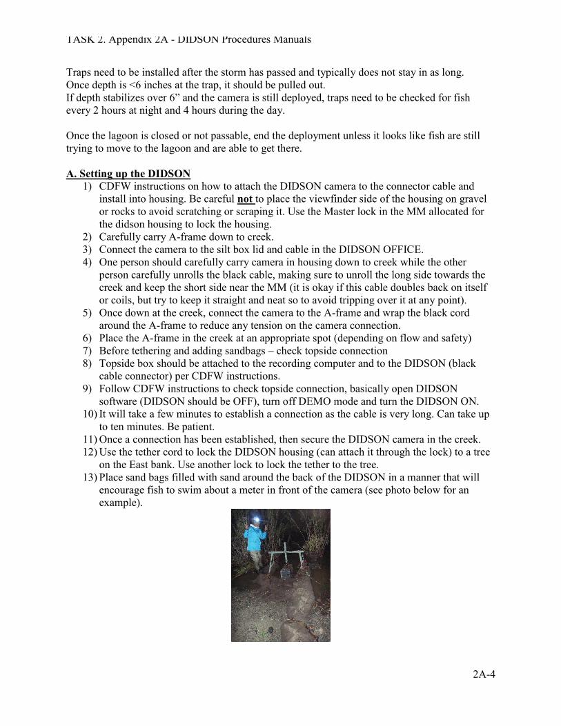
1) CDFW instructions on how to attach the DIDSON camera to the connector cable and install into housing. Be careful not to place the viewfinder side of the housing on gravel or rocks to avoid scratching or scraping it. Use the Master lock in the MM allocated for the didson housing to lock the housing.
2) Carefully carry A-frame down to creek. 3) Connect the camera to the silt box lid and cable in the DIDSON OFFICE. 4) One person should carefully carry camera in housing down to creek while the other
person carefully unrolls the black cable, making sure to unroll the long side towards the creek and keep the short side near the MM (it is okay if this cable doubles back on itself or coils, but try to keep it straight and neat so to avoid tripping over it at any point).
5) Once down at the creek, connect the camera to the A-frame and wrap the black cord around the A-frame to reduce any tension on the camera connection.
6) Place the A-frame in the creek at an appropriate spot (depending on flow and safety) 7) Before tethering and adding sandbags – check topside connection 8) Topside box should be attached to the recording computer and to the DIDSON (black
cable connector) per CDFW instructions. 9) Follow CDFW instructions to check topside connection, basically open DIDSON
software (DIDSON should be OFF), turn off DEMO mode and turn the DIDSON ON. 10) It will take a few minutes to establish a connection as the cable is very long. Can take up
to ten minutes. Be patient. 11) Once a connection has been established, then secure the DIDSON camera in the creek. 12) Use the tether cord to lock the DIDSON housing (can attach it through the lock) to a tree
on the East bank. Use another lock to lock the tether to the tree. 13) Place sand bags filled with sand around the back of the DIDSON in a manner that will
encourage fish to swim about a meter in front of the camera (see photo below for an example).
TASK 2. Appendix 2A - DIDSON Procedures Manuals
2A-5
14) Once the camera is secure, set save directory a. Set up a folder on one of the external hard drives named with the deployment date
and location (e.g., Topanga_28 Feb 2014) b. Save (should be set to save as the date and time in HHMMSS). Do not add
anything to the Save As file name. Ex.: 2014-02-28_134000_HF.ddf c. Make sure Auto Rate, Auto Frequency and HF are all selected and adjust window
length as needed (see CDFW instructions for details) d. Start Recording!
B. Data collection and note taking At the start of each deployment, a WORD document for notes and personnel tracking, and an EXCEL spreadsheet for data entry, should be set up on the processing computer. Lead person from each shift (likely the same person processing videos) should record shift time and personnel and any notes taken during the shift. Review all previous data and notes at the end/start of each shift and update whomever is taking over next shift. At a minimum, the following notes should be taken during each shift:
x Hourly, and as needed, field checks on DIDSON camera position x Any time the DIDSON is adjusted or moved and how/where it was adjusted or moved x Hourly measurements of turbidity, water and air temperatures, total rainfall (rain gauge
and LACDPW WRD) x Flow (cfs) measurements, when possible. Do not take flow if you feel unsafe or if you see
many fish swimming by. x Lagoon monitoring – check tides and go visit the lagoon to check passability as often as
needed. More frequent as flows decline. x Fish trap monitoring – lock the DIDSON Office at night and whole team go in one car to
the weir trap. C. Video processing In order to avoid any missing images, at least every six hours all new DIDSON files should be backed up from the recording external hard drive onto the second processing external hard drive. When ejecting the processing hard drive, make sure you are ejecting the correct one! The hard drives are labeled, the USB ports are labeled, and you can see real-time images being saved on the recording drive, so make sure you have the correct drive. Process data from each six hour time period, recording onto the appropriate data sheets. Once a six hour time period is complete or at the end of your shift, you should enter all processing data into the appropriate EXCEL spreadsheet.
TASK 2. Appendix 2A - DIDSON Procedures Manuals
2A-6
V. SETTING UP THE TRAP The stakes and weir frames are staged at Fish Camp and locked together to a willow tree. Other equipment will be either in the shed or in the DIDSON OFFICE. Be sure and take the correct keys to the site! Equipment needed to set up the traps: 1. Weir panels (at Fish Camp) 2. fence posts (at Fish Camp) 3. post pounder 4. hard hat and ear plugs 5. long zip ties to tie panels together and to the fence posts (14”) 6. short zip ties for tying the sandbags 7. dikes and wire cutters to cut the zip ties 8. tarps to cover the boxes 9. big net to check the boxes 10. 4 buckets 11. waders 12. 2 shovels 13. loppers 14. Fish processing box that contains: pit tag master list on clipboard pit tag reader pit tags prepared in envelops ready to use fish kit containing scale knife, scalpel and blades, alcohol, scissors for fin clips, tweezers to change scalpel blades, Vet Bond MS-222 FISH MEASURING BOARD Camera Dip nets to move fish to and from buckets Put together the connected upstream weir panels with bottom netting on shore! Tag should be on the upstream side! Carry to the creek and secure with fence posts. Be sure to securely fasten the wood part that keeps the panels open for fish access! Attach the labeled downstream panels and secure to the upstream side. Install the panels both up and downstream to direct fish into the openings. Be sure to feel along the bottom and make sure there are no holes under the panels. Use sandbags to fill in any gaps. Use a tarp to cover the tops of the up and downstream boxes and lay fence posts on top to hold them in the wind.
TASK 2. Appendix 2A - DIDSON Procedures Manuals
2A-7
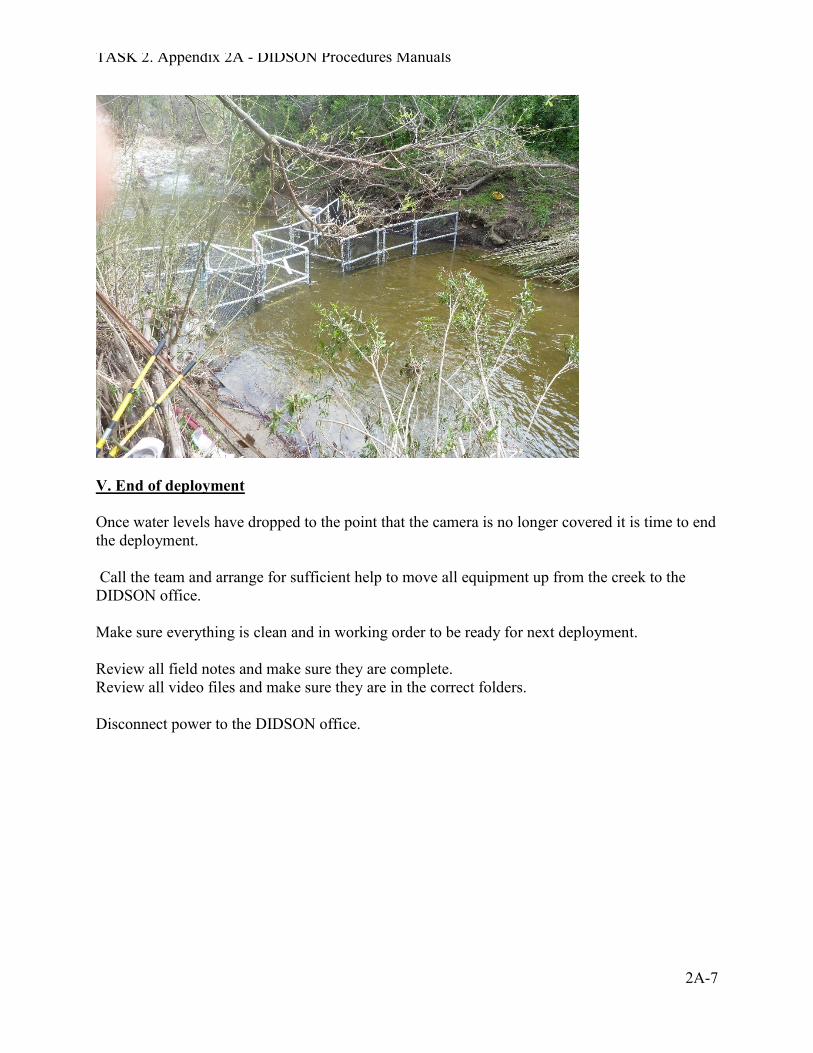
V. End of deployment Once water levels have dropped to the point that the camera is no longer covered it is time to end the deployment. Call the team and arrange for sufficient help to move all equipment up from the creek to the DIDSON office. Make sure everything is clean and in working order to be ready for next deployment. Review all field notes and make sure they are complete. Review all video files and make sure they are in the correct folders. Disconnect power to the DIDSON office.
TASK 2. Appendix 2A - DIDSON Procedures Manuals
2A-8
DIDSON Hardware Procedures
Equipment List: 1. Tools
a. 7/16 wrench b. Flat head screw driver
2. DIDSON Pelican Case a. DIDSON b. Topside box c. Topside box power cable d. Ethernet cable e. Bolts
3. DIDSON Cable a. 500ft cable on spool
4. Silt Box and Metal Debris Box a. Attached with metal plate b. Has attached ball mount c. Lock (keeps debris box closed and prevents easy access to the DIDSON)
5. Mount a. A frame b. 3 locking pins c. Ball joint
6. Laptop Computer a. Power cord
7. External hard drive a. All necessary cords
8. A “can-do” attitude -
TASK 2. Appendix 2A - DIDSON Procedures Manuals
2A-9
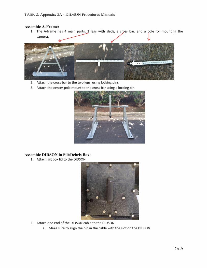
Assemble A-Frame: 1. The A-frame has 4 main parts, 2 legs with sleds, a cross bar, and a pole for mounting the
camera.
2. Attach the cross bar to the two legs, using locking pins 3. Attach the center pole mount to the cross bar using a locking pin
Assemble DIDSON in Silt/Debris Box:
1. Attach silt box lid to the DIDSON
2. Attach one end of the DIDSON cable to the DIDSON
a. Make sure to align the pin in the cable with the slot on the DIDSON
TASK 2. Appendix 2A - DIDSON Procedures Manuals
2A-10
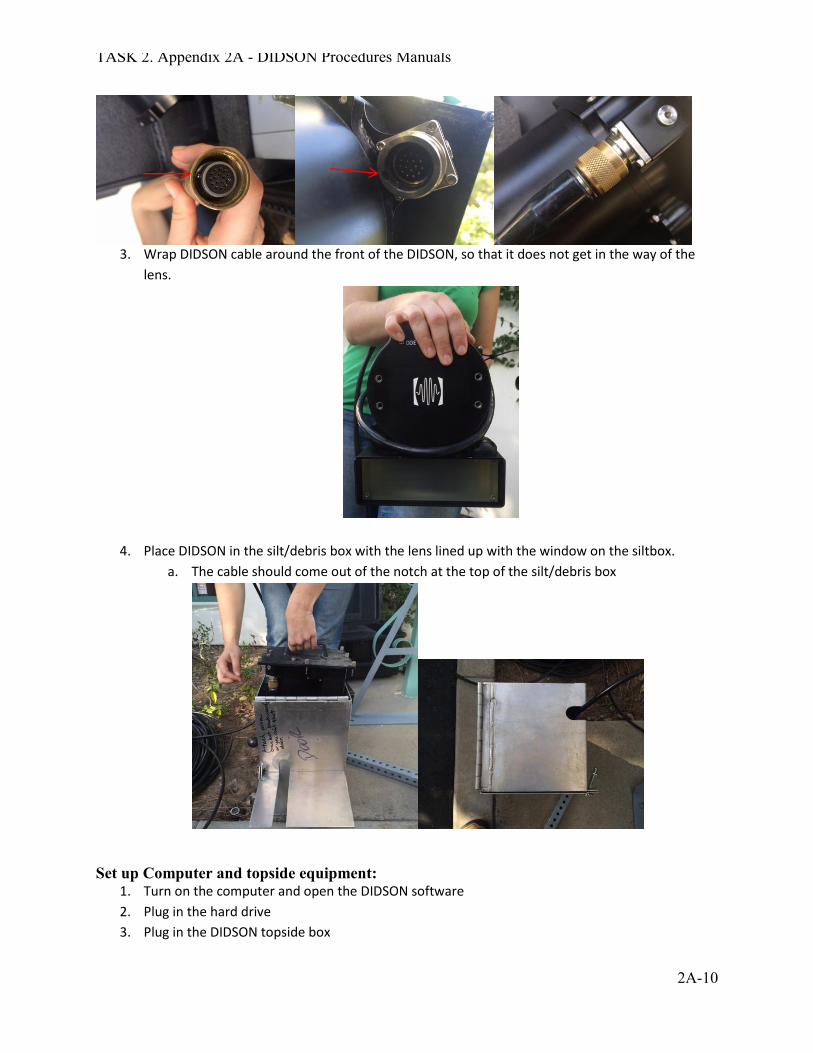
3. Wrap DIDSON cable around the front of the DIDSON, so that it does not get in the way of the
lens.
4. Place DIDSON in the silt/debris box with the lens lined up with the window on the siltbox. a. The cable should come out of the notch at the top of the silt/debris box
Set up Computer and topside equipment:
1. Turn on the computer and open the DIDSON software 2. Plug in the hard drive 3. Plug in the DIDSON topside box

TASK 2. Appendix 2A - DIDSON Procedures Manuals
2A-11
a. Make sure the topside box is off 4. Plug the blue DIDSON Ethernet cable into the topside box (where it says PC) and then into the
computer 5. See DIDSON Software procedures for DIDSON software setup and recording
TASK 2. Appendix 2A - DIDSON Procedures Manuals
2A-12
DIDSON Software Procedures
Powering up the DIDSON
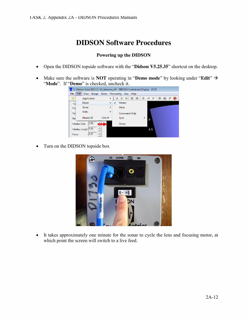
x Open the DIDSON topside software with the “Didson V5.25.35” shortcut on the desktop. x Make sure the software is NOT operating in “Demo mode” by looking under “Edit” Æ
“Mode”. If “Demo” is checked, uncheck it.
x Turn on the DIDSON topside box
x It takes approximately one minute for the sonar to cycle the lens and focusing motor, at
which point the screen will switch to a live feed.
TASK 2. Appendix 2A - DIDSON Procedures Manuals
2A-13
Recording with the DIDSON
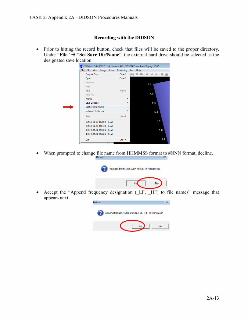
x Prior to hitting the record button, check that files will be saved to the proper directory.
Under “File” Æ “Set Save Dir/Name”, the external hard drive should be selected as the designated save location.
x When prompted to change file name from HHMMSS format to #NNN format, decline.
x Accept the “Append frequency designation (_LF, _HF) to file names” message that
appears next.
TASK 2. Appendix 2A - DIDSON Procedures Manuals
2A-14
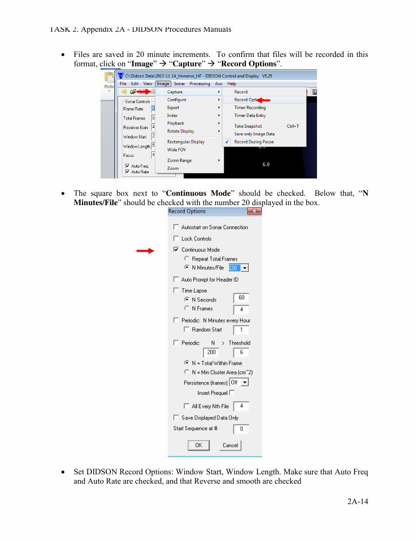
x Files are saved in 20 minute increments. To confirm that files will be recorded in this format, click on “Image” Æ “Capture” Æ “Record Options”.
x The square box next to “Continuous Mode” should be checked. Below that, “N Minutes/File” should be checked with the number 20 displayed in the box.
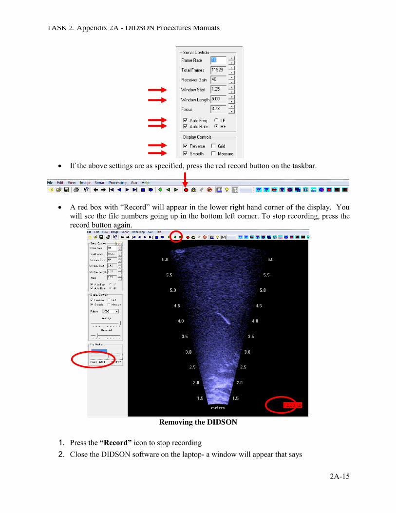
x Set DIDSON Record Options: Window Start, Window Length. Make sure that Auto Freq
and Auto Rate are checked, and that Reverse and smooth are checked
TASK 2. Appendix 2A - DIDSON Procedures Manuals
2A-15
x If the above settings are as specified, press the red record button on the taskbar.
x A red box with “Record” will appear in the lower right hand corner of the display. You will see the file numbers going up in the bottom left corner. To stop recording, press the record button again.
Removing the DIDSON
1. Press the “Record” icon to stop recording 2. Close the DIDSON software on the laptop- a window will appear that says

TASK 2. Appendix 2A - DIDSON Procedures Manuals
2A-16
“please wait while the lens is being retracted”, a second window will notify you when the retraction is complete
3. Turn off the Top Side Box, you can now remove the DIDSON from the stream 4. Disconnect the Top Side Box by disconnecting the Ethernet cable, sonar cable and power
cables 5. Eject the external hard drive, and power down the computer 6. Disassemble the DIDSON, making sure to put all hardware in the appropriate locations
TASK 2. Appendix 2A - DIDSON Procedures Manuals
2A-17
DIDSON Analysis updated 12.16.14
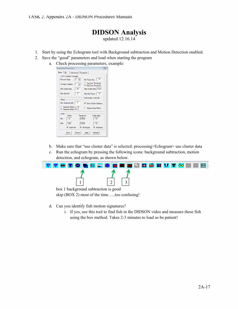
1. Start by using the Echogram tool with Background subtraction and Motion Detection enabled. 2. Save the “good” parameters and load when starting the program
a. Check processing parameters, example:
b. Make sure that “use cluster data” is selected: processing>Echogram> use cluster data c. Run the echogram by pressing the following icons: background subtraction, motion
detection, and echogram, as shown below.
box 1 background subtraction is good skip (BOX 2) most of the time…..too confusing!
d. Can you identify fish motion signatures? i. If yes, use this tool to find fish in the DIDSON video and measure these fish
using the box method. Takes 2-3 minutes to load so be patient!
1 2 3
TASK 2. Appendix 2A - DIDSON Procedures Manuals
2A-18
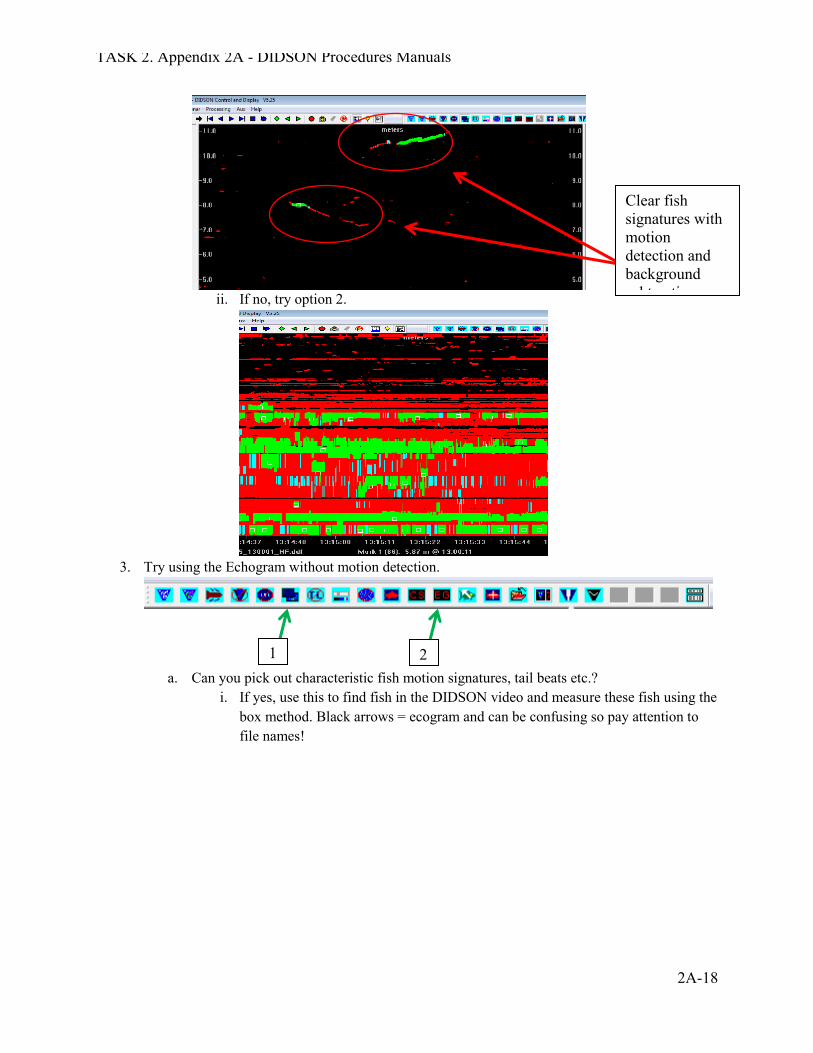
ii. If no, try option 2.
3. Try using the Echogram without motion detection.
a. Can you pick out characteristic fish motion signatures, tail beats etc.? i. If yes, use this to find fish in the DIDSON video and measure these fish using the
box method. Black arrows = ecogram and can be confusing so pay attention to file names!
2
Clear fish signatures with motion detection and background subtraction
1
TASK 2. Appendix 2A - DIDSON Procedures Manuals
2A-19
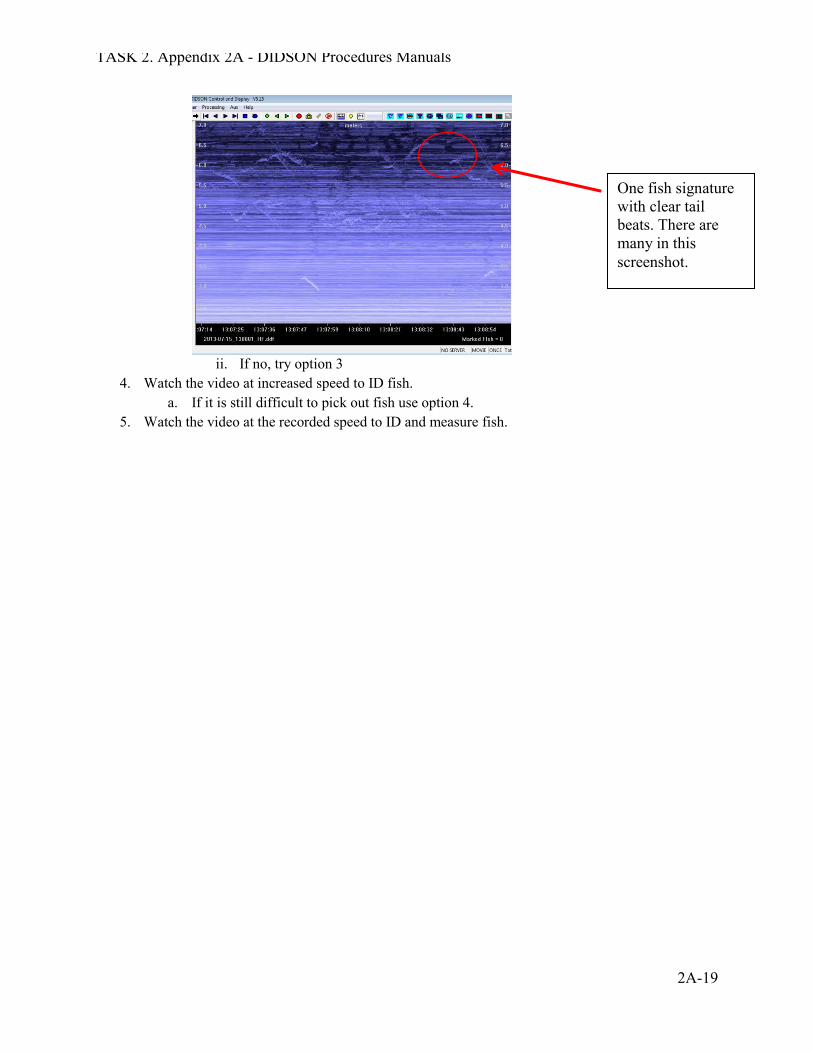
ii. If no, try option 3
4. Watch the video at increased speed to ID fish. a. If it is still difficult to pick out fish use option 4.
5. Watch the video at the recorded speed to ID and measure fish.
One fish signature with clear tail beats. There are many in this screenshot.
TASK 2. Appendix 2A - DIDSON Procedures Manuals
2A-20
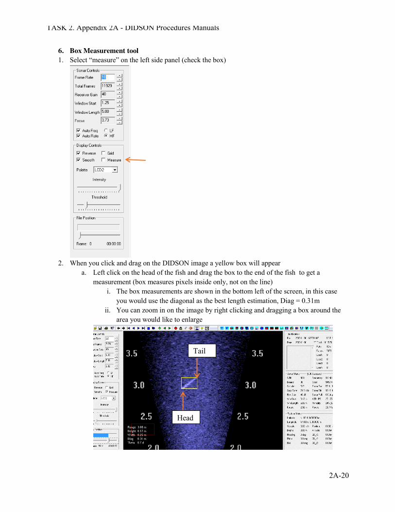
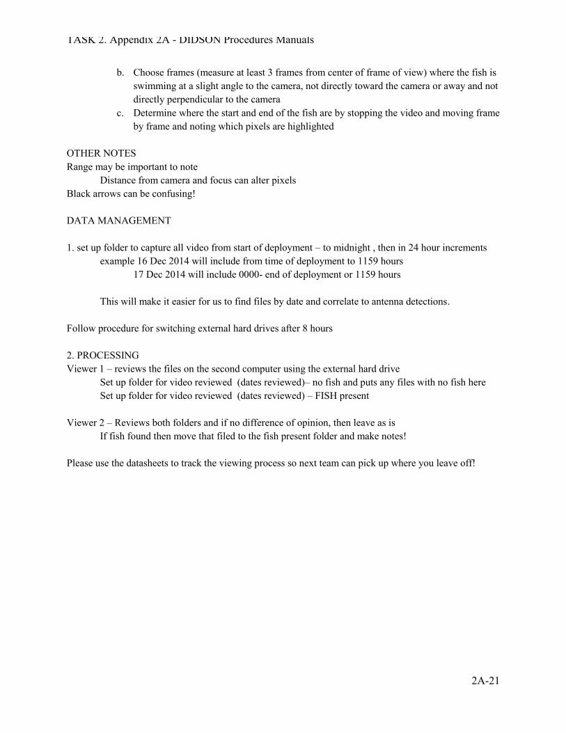
6. Box Measurement tool 1. Select “measure” on the left side panel (check the box)
2. When you click and drag on the DIDSON image a yellow box will appear
a. Left click on the head of the fish and drag the box to the end of the fish to get a measurement (box measures pixels inside only, not on the line)
i. The box measurements are shown in the bottom left of the screen, in this case you would use the diagonal as the best length estimation, Diag = 0.31m
ii. You can zoom in on the image by right clicking and dragging a box around the area you would like to enlarge
Head
Tail
TASK 2. Appendix 2A - DIDSON Procedures Manuals
2A-21
b. Choose frames (measure at least 3 frames from center of frame of view) where the fish is swimming at a slight angle to the camera, not directly toward the camera or away and not directly perpendicular to the camera
c. Determine where the start and end of the fish are by stopping the video and moving frame by frame and noting which pixels are highlighted
OTHER NOTES Range may be important to note Distance from camera and focus can alter pixels Black arrows can be confusing! DATA MANAGEMENT 1. set up folder to capture all video from start of deployment – to midnight , then in 24 hour increments example 16 Dec 2014 will include from time of deployment to 1159 hours 17 Dec 2014 will include 0000- end of deployment or 1159 hours This will make it easier for us to find files by date and correlate to antenna detections. Follow procedure for switching external hard drives after 8 hours 2. PROCESSING Viewer 1 – reviews the files on the second computer using the external hard drive Set up folder for video reviewed (dates reviewed)– no fish and puts any files with no fish here Set up folder for video reviewed (dates reviewed) – FISH present Viewer 2 – Reviews both folders and if no difference of opinion, then leave as is If fish found then move that filed to the fish present folder and make notes! Please use the datasheets to track the viewing process so next team can pick up where you leave off!
Appendix 2B
DIDSON Deployment Field Notes
TASK 2. ANADROMOUS ADULT AND SMOLT MONITORING WITH DIDSON CAMERA IN TOPANGA CREEK
SANTA MONICA BAY ANADROMOUS ADULT AND JUVENILE
STEELHEAD MONITORING 2012-2018
Prepared for CDFW contract No P1250013
Prepared by:
RCD of the Santa Monica Mountains 540 S. Topanga Canyon Blvd.
Topanga, CA 90290
May 2018
TASK 2. Appendix 2B - DIDSON Deployment Field Notes
2B-1
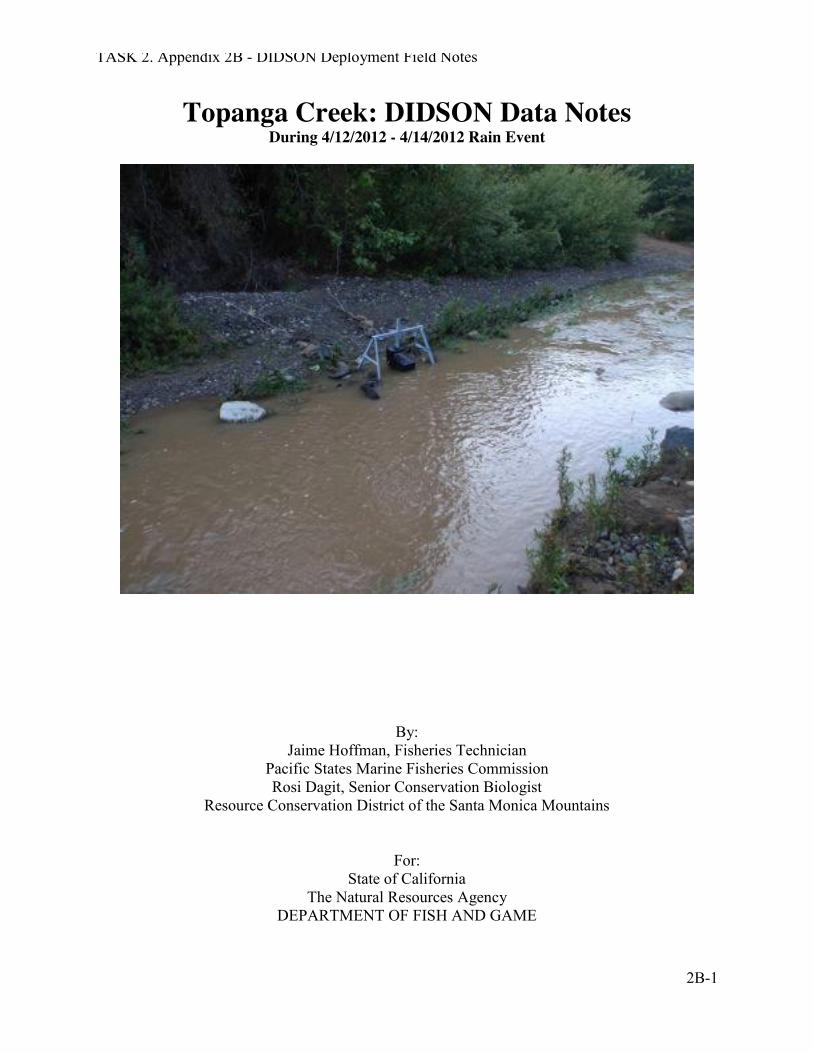
Topanga Creek: DIDSON Data Notes During 4/12/2012 - 4/14/2012 Rain Event
By: Jaime Hoffman, Fisheries Technician
Pacific States Marine Fisheries Commission Rosi Dagit, Senior Conservation Biologist
Resource Conservation District of the Santa Monica Mountains
For: State of California
The Natural Resources Agency DEPARTMENT OF FISH AND GAME
TASK 2. Appendix 2B - DIDSON Deployment Field Notes
2B-2
Acknowledgements: There are far too many people that have contributed to make this first DIDSON deployment in Topanga Creek possible. Rosi Dagit from the RCD of the Santa Monica Mountains was instrumental in the planning and organizational aspects of the project. Jenna Krug, Steve Williams, Ken Wheeland and the rest of the RCD of the Santa Monica Mountains provided a great deal of help to project operations. We would also like to thank Jill Taylor and Dillon Brook of the CCC for their contributions. As well as Stan Allen of PSMFC, Mary Larson, Dana McCanne and Chris Lima of the CDFG for their continued support. As well Gaytha Morningstar PSMFC, Ester Ball CDFG, Paul Lopez PSMFC and the many others who helped us make this project possible.
TASK 2. Appendix 2B - DIDSON Deployment Field Notes
2B-3
This document is meant to provide an overview of both the data collected during the April 12th -14th, 2012 rain event at Topanga Creek as well as the issues/problems that were encountered while processing the collected sonar data. The DIDSON was deployed around 6:20 pm on April 12th and removed at 9:40 am on April 14th. The peak flow occurred mid-afternoon on 13 April about 3 hours after the rain ended.
Background: Since 2008, we have been conducting a mark-recapture lifecycle monitoring program in Topanga Creek. As of March 2012, a total of 591 O. mykiss have been PIT tagged. As part of this effort, we deploy an instream antenna during the rainy season between November and May each year. We also install upstream and downstream weir traps when possible, usually on the falling limb of the hydrograph due to the flashy nature of flows in Topanga Creek that make it unsafe for traps to be deployed during peak flows. The opportunity to experiment with placing the DIDSON camera adjacent to the antenna allowed us to examine fish movement during flow conditions when trapping is not possible. As part of our on-going monitoring we also conduct monthly snorkel surveys. In anticipation of the April rain events, we snorkeled in Topanga on Thursday 12 April. Due to high flow and reduced visibility in the upper reaches, the survey covered only 0-5000 meters. During this survey, a total of 88 O. mykiss were observed.
Rainfall Information: Between November 2011 and January 2012, Topanga Creek received a total of 7.41 inches of rain brought by several pulses of storms. Between January and 25 March 2012 (when a 2.8” event was recorded), there were scattered storms that totaled another 6 inches. The rain on 11 April brought 0.9 inches, and then the following storm arrived mid-day on 13 April and added another 1.4 inches. The total rainfall for the water year is 16.51 inches. Lagoon/Ocean Interface condition: Due to the low amounts of precipitation and long intervals between storms, the sand berm that closes off the mouth of Topanga Creek remained in place for much of the potential movement window for O. mykiss. The creek was connected to the ocean for limited duration, and a slug of sandy sediments created a narrow, shallow thalweg and limited migration passage opportunities. The creek breached the berm on Wed, 11 April, and it remained connected until later in the month, although after 19 April it was mostly connected by overwash at high tides. There was full connectivity during the deployment of the DIDSON camera. DIDSON Data Summary: The data collected on 4/12 through 4/14 was analyzed using the Echogram (EG) feature on the DIDSON Soundmetrics topside software. A total of 91 20 minute files were recorded, of which 72 were readable. The results were then put into an excel file, seen below.
TASK 2. Appendix 2B - DIDSON Deployment Field Notes
2B-4
In total, 18 out migrating trout sized 150 mm to 270 mm were captured by the DIDSON unit during the rain event. No fish were observed moving upstream by the sonar unit. The fish moved between the hours of 1940-2120 hours on 12 April, immediately following the installation of the camera but prior to the onset of the next rain event. The rain began at around 1130 hrs on 13 April, with heavy showers lasting for several hours. The peak flow arrived at the camera location at 1430 hrs, raising the water level and requiring movement of the camera. The adjustments made to camera position in the creek and subsequent computer modifications caused the data to be unreadable until 2000 that evening, which means we do not know if fish were moving throughout that time or not. As soon as the camera was reset properly at 2020 hrs, fish movement was observed until almost midnight (0000 hrs). There was a short lull, and then fish movement was observed between 0200 and 0720 hrs.
On April 12th around 7:40 pm a tagged fish sized 355mm was recorded passing the sonar unit as it traveled downstream and was also noted by the instream antenna. In the DIDSON software the fish was manually measured to be ~270mm. The other tagged fish sized 164 mm that moved downstream on April 13th was not captured by the DIDSON, only by the antenna. During this time period, the window length, focus and angle of the sonar unit were incorrectly configured making analysis of the data nearly impossible. During this 30+ hour deployment event, about 6 hours of the recorded data are impossible to analyze and are denoted on the excel tables as “-1”. This was due to improper movement and camera alignment.
While the first deployment of the DIDSON in Topanga Creek was bound to encounter issues, the project overall was a great success. The categories described below are not ranked, so the order they are presented in is not indicative of their importance.
TASK 2. Appendix 2B - DIDSON Deployment Field Notes
2B-5
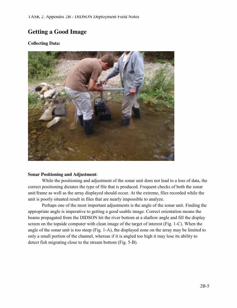
Getting a Good Image Collecting Data:
Sonar Positioning and Adjustment:
While the positioning and adjustment of the sonar unit does not lead to a loss of data, the correct positioning dictates the type of file that is produced. Frequent checks of both the sonar unit/frame as well as the array displayed should occur. At the extreme, files recorded while the unit is poorly situated result in files that are nearly impossible to analyze.
Perhaps one of the most important adjustments is the angle of the sonar unit. Finding the appropriate angle is imperative to getting a good usable image. Correct orientation means the beams propagated from the DIDSON hit the river bottom at a shallow angle and fill the display screen on the topside computer with clean image of the target of interest (Fig. 1-C). When the angle of the sonar unit is too steep (Fig. 1-A), the displayed zone on the array may be limited to only a small portion of the channel, whereas if it is angled too high it may lose its ability to detect fish migrating close to the stream bottom (Fig. 5-B).
TASK 2. Appendix 2B - DIDSON Deployment Field Notes
2B-6
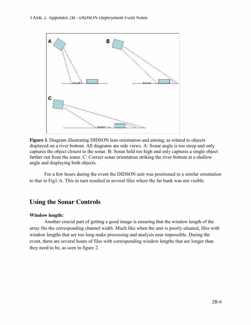
Figure 1. Diagram illustrating DIDSON lens orientation and aiming, as related to objects displayed on a river bottom. All diagrams are side views. A: Sonar angle is too steep and only captures the object closest to the sonar. B: Sonar held too high and only captures a single object farther out from the sonar. C: Correct sonar orientation striking the river bottom at a shallow angle and displaying both objects.
For a few hours during the event the DIDSON unit was positioned in a similar orientation to that in Fig1-A. This in turn resulted in several files where the far bank was not visible.
Using the Sonar Controls Window length:
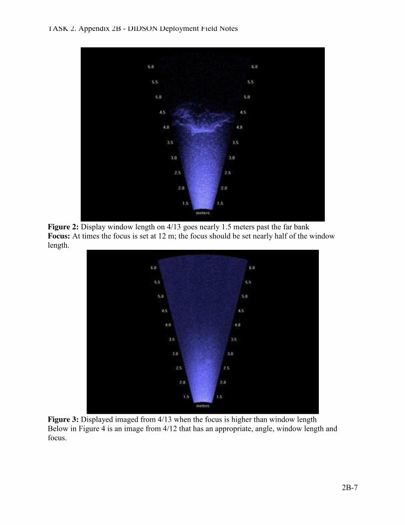
Another crucial part of getting a good image is ensuring that the window length of the array fits the corresponding channel width. Much like when the unit is poorly situated, files with window lengths that are too long make processing and analysis near impossible. During the event, there are several hours of files with corresponding window lengths that are longer than they need to be, as seen in figure 2.
TASK 2. Appendix 2B - DIDSON Deployment Field Notes
2B-7
Figure 2: Display window length on 4/13 goes nearly 1.5 meters past the far bank Focus: At times the focus is set at 12 m; the focus should be set nearly half of the window length.
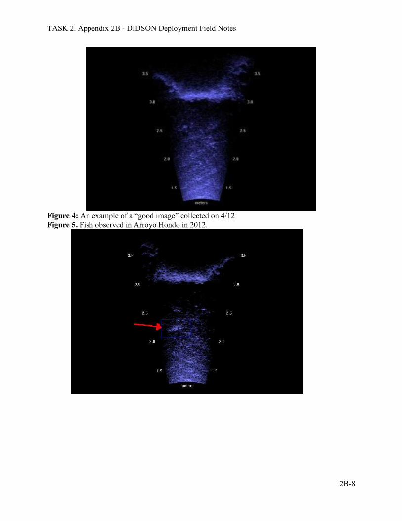
Figure 3: Displayed imaged from 4/13 when the focus is higher than window length Below in Figure 4 is an image from 4/12 that has an appropriate, angle, window length and focus.
TASK 2. Appendix 2B - DIDSON Deployment Field Notes
2B-8
Figure 4: An example of a “good image” collected on 4/12 Figure 5. Fish observed in Arroyo Hondo in 2012.
TASK 2. Appendix 2B - DIDSON Deployment Field Notes
2B-9
What we learned: 1. Training: Because this deployment was done on the spur of the moment, it was not
possible to properly train all staff on the manipulation and intricacies of this equipment. Given the brief time when trained staff was available, it is great that we got as much usable data as we did. For the future, we need to provide adequate training for key staff to ensure that data collection is as consistent as possible.
2. Staffing Logistics: For safety and data quality considerations, it is critical to have 2 people attending the camera during deployment at all times. One person needs to have sufficient training to move and manipulate the camera so that it is recording properly. The second person does not need to be as skilled, but needs to be available to help move the camera, and assist as needed. Ideally, in addition to the recording computer and external hard drive, there should be a second computer with internet connection in the trailer. The data collected on the external hard drive can then be moved to the second computer for analysis, while the main computer continues to record data. Doing data analysis while at the site provides several benefits. First, if there are problems with the images, corrections can be made. Second, since it takes almost as much time to analyze the data as it does to record it, using the time staff are already sitting at the camera site to do both data collection and analysis makes sense.
3. Deployment constraints: In this case, we observed a storm approaching and decided to deploy the camera within 24 hours. Because it is so labor intensive to have 2 people attending the camera at all times, we will need to have a consistent and well thought out procedure for deciding when to set up and take down the camera. Based on the experience of this trial, it appears that the fish begin moving prior to the arrival of the rain, perhaps in response to changes in atmospheric pressure associated with the fronts. This would suggest that deploying the camera 24 hours before a storm makes sense. If the camera confirms that fish rarely move during daylight hours, as we have found in the trapping efforts, it may be possible to set up the camera in late afternoon, pull it out around 0900, and not have to worry about daytime deployment unless it is actually raining. Until we spend more time observing the fish movement, it seems that we should prepare to deploy and keep the camera in place for as long as possible based on staff availability.
4. Location considerations: One of the concerns in camera placement is ensuring that the field of view is such that the fish are not “milling” about, but rather moving up or downstream. The substrate needs to be fairly smooth to avoid turbulence around cobbles and boulders that obscure the image. Deploying the camera within 10-15 meters upstream of the antenna allowed us to correlate data collected by both devices and was very helpful. This also allowed us to determine that there are a significant number of untagged fish moving out of the system. One possible problem was that the camera position during
TASK 2. Appendix 2B - DIDSON Deployment Field Notes
2B-10
this deployment was that the slab of concrete embedded in the creek may have provided a “raceway” where fish moved so quickly across the field of view that they were difficult to measure.
Another consideration should be the status of the creek banks. Having one bank with a gentler slope allowed us to move the camera as flows increased fairly easily to a position where fish could not swim behind the camera device. It also provided a safe passage for staff to move along the bank during the peak flow.
Positioning the camera in the creek so that the device is secure during increasing flows and when the channel width and depth expands is critical. We found that using cobbles and boulders from the channel as deflection barriers to ensure that fish could not swim behind the camera worked well, but were not sufficient to keep the camera tight to the substrate when the flashy flows hit all at once. For future deployments, a more secure system of fence posts might also be helpful.
Finally, if the camera is to be deployed for more than 2-3 days, the trailer needs to be located where it can absorb as much sun as possible to keep the solar power battery charging process going. Placing the trailer on flat ground is also key!
5. Setting up the Camera and Field Notes: When the camera is deployed, the wetted width of the channel at the camera location, as well as depth at the camera box should be recorded. This information should be noted hourly during the entire deployment, and more frequently when peak flows hit. A rain gage should be installed near the camera so that rainfall patterns can be documented. This will help in analyzing the flow patterns correlated to camera efficiency and fish movement.
A rite-in-the-rain bound field notebook should be part of the camera set up and kept in the trailer at all times. Hourly notes should be made concerning staff present, rainfall amounts, wetted width and depth, observations of other wildlife (ducks, frogs, etc.), problems with computer, and any other notes to document the chain of events during the camera deployment.
6. Lagoon conditions and tides: In the flashy systems such as Topanga Creek, it is critical to also monitor the tidal stage and ocean/creek mouth connectivity during the camera deployment. This will provide key information on fish movement related to ocean accessibility.
7. Importance of Watershed knowledge: It is important to have an understanding of the overall watershed patterns, especially any time lags between heavy rain and peak flows arriving at the camera location. By tracking the storm movements on the internet, this will enhance safety of staff working with the camera, as well as provide key data on how upper watershed rainfall patterns coalesce and impact flows in the mainstem of the creek and the lagoon/ocean interface.
TASK 2. Appendix 2B - DIDSON Deployment Field Notes
2B-11
RECOMMENDATIONS FOR FUTURE EVENTS 1. It would really help to have a Quick Checklist of Instructions, Do’s and Don’ts
reference sheet with important information regarding camera management, along with the longer manual available in the trailer. Additionally, a list of important contact phone numbers should be taped on the trailer wall.
2. Having a second computer with internet access would allow data processing while the camera is also recording, and would provide added safety by allowing real time storm monitoring.
3. An experienced camera person should be present at all times, with less experienced staff assisting and learning.
4. All connecting cables should be labeled with length and any other important information.
5. The trailer should also include the following additional equipment:
Rain gage, meter stick, meter tape, flagging tape, waterproof walkie talkies, door mat to catch mud, small broom, towels, first aid kit.
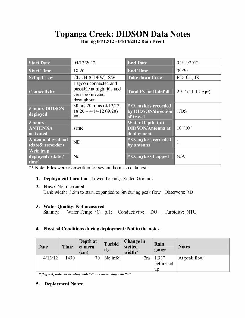
Topanga Creek: DIDSON Data Notes During 04/12/12 - 04/14/2012 Rain Event
** Note: Files were overwritten for several hours so data lost.
1. Deployment Location: Lower Topanga Rodeo Grounds
2. Flow: Not measured Bank width: 3.5m to start, expanded to 6m during peak flow Observers: RD
3. Water Quality: Not measured Salinity: Water Temp: °C pH: Conductivity: DO: Turbidity: NTU
4. Physical Conditions during deployment: Not in the notes
Date Time Depth at camera (cm)
Turbidity
Change in wetted width*
Rain gauge Notes
4/13/12 1430 70 No info 2m 1.33” before set up
At peak flow
* flag = 0; indicate receding with “-“ and increasing with “+”
5. Deployment Notes:
Start Date 04/12/2012 End Date 04/14/2012
Start Time 18:20 End Time 09:20 Setup Crew CL, JH (CDFW), SW Take down Crew RD, CL, JK
Connectivity
Lagoon connected and passable at high tide and creek connected throughout
Total Event Rainfall 2.5 “ (11-13 Apr)
# hours DIDSON deployed
30 hrs 20 mins (4/12/12 18:20 – 4/14/12 09:20) **
# O. mykiss recorded by DIDSON/direction of travel
1/DS
# hours ANTENNA activated
same Water Depth (in) DIDSON/Antenna at deployment
10"/10”
Antenna download (date& recorder) ND # O. mykiss recorded
by antenna 1
Weir trap deployed? (date / time)
No # O. mykiss trapped N/A
TASK 2. Appendix 2B - DIDSON Deployment Field Notes
2B-13
This effort was spur of the moment and our first deployment effort, which meant some data did not get collected. The camera was installed just upstream of the old Rodeo Grounds Rd. instream crossing on the east bank, to make access possible. Camera was anchored to a willow tree and then connected to the solar trailer. Flow was initially steady, but peaked at 1430 on 4/13 within 15 minutes, requiring movement back to prevent fish from swimming behind the camera and resulted in some lost data files.
6. Antenna Notes: One fish observed moving DS on 4/12/12 at 1954, Pit Tag # 178695858, which was initially tagged on 11/14/11 at 2.0 RKM and measured 140 mm FL. This fish was subsequently captured again on 03/20/12 and measured 164 mm. Smolting condition was not noted.
7. Analysis Notes: Analysis by: Jaime Hoffman did the intial review followed by subsequent review and revision by Sam Bankston and Heidi Block. Final QAQC revealed that what initially had been thought to be a trout was not. Only a single downstream migrant was confirmed.
Analysis Date(s): Summer 2012
Jaime Hoffman reviewed a total of 91 20 minute files, of which 72 were readable. He observed what he thought were 18 outmigrating fish ranging in estimated size from 120-270 mm FL based on video measurements. Subsequent review of the images by H. Block and S. Bankston reduced this to only 1 individual.
8. QA/QC Summary: Summary table of only O. mykiss records:
Initial Recorder
Avg Length
(cm) QAQ
C1
Avg Length
(cm) QAQC
2
Avg Length
(cm)
Trout (Y/N)
Overall Avg
Length (cm)
Time of Passage
Direction
JH 20 HB 19 SB 23 Y 20 1946 DS JH 20 HB 20 SB 20 Y 20 1951 DS
Summary of "Non-trout/other" records: None of the entries recorded by the processor as non-trout/other were falsely interpreted. Chorus frogs, crayfish, ducks and unidentified small fish (most likely Arroyo chub) were observed.
Confidence on a scale from 1 to 3 (1=extremely, 3=not confident) that no trout were missed during viewing and processing the footage =3 not confident (there were issues with recording so some hours lost)
9. Table of Personnel:
Name Abbr. Affiliation Date Shift Total hours
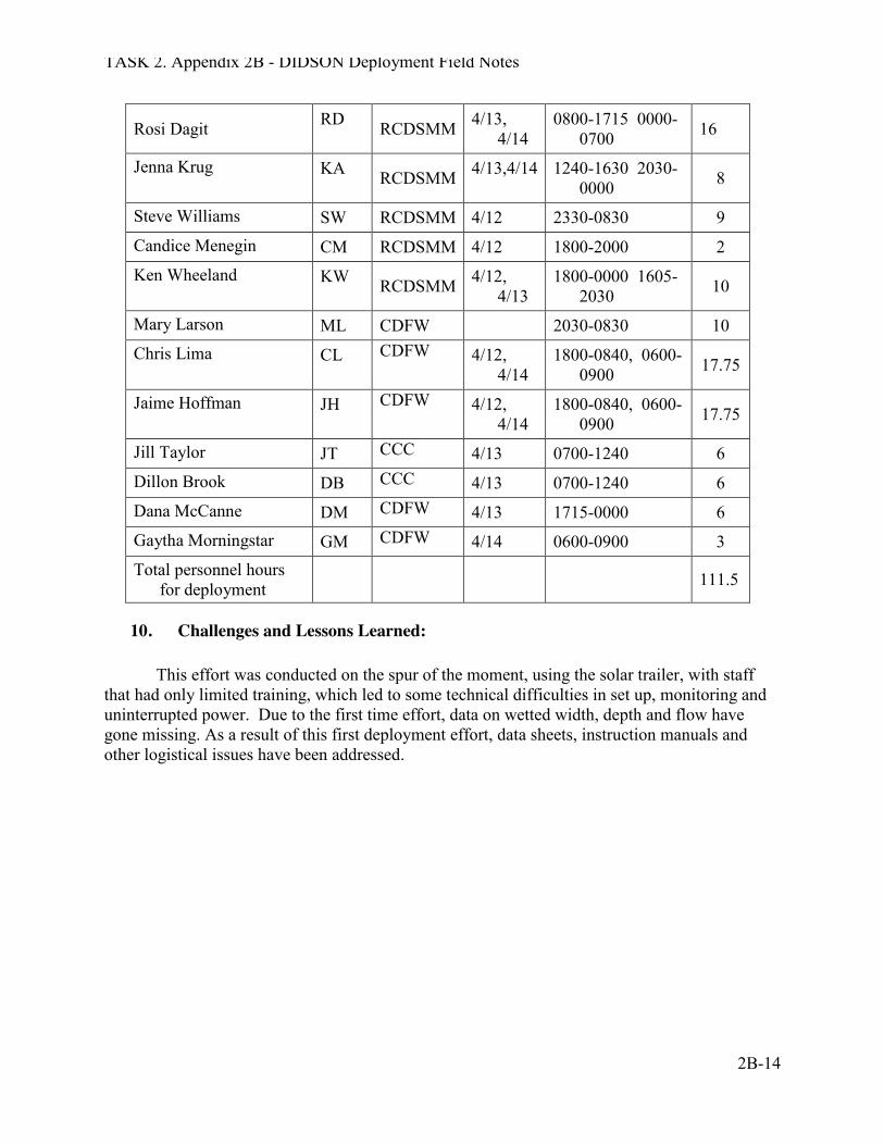
TASK 2. Appendix 2B - DIDSON Deployment Field Notes
2B-14
Rosi Dagit RD RCDSMM 4/13, 4/14
0800-1715 0000-0700 16
Jenna Krug KA RCDSMM 4/13,4/14 1240-1630 2030-0000 8
Steve Williams SW RCDSMM 4/12 2330-0830 9 Candice Menegin CM RCDSMM 4/12 1800-2000 2 Ken Wheeland KW RCDSMM 4/12,
4/13 1800-0000 1605-
2030 10
Mary Larson ML CDFW 2030-0830 10 Chris Lima CL CDFW 4/12,
4/14 1800-0840, 0600-
0900 17.75
Jaime Hoffman JH CDFW 4/12, 4/14
1800-0840, 0600-0900 17.75
Jill Taylor JT CCC 4/13 0700-1240 6 Dillon Brook DB CCC 4/13 0700-1240 6 Dana McCanne DM CDFW 4/13 1715-0000 6 Gaytha Morningstar GM CDFW 4/14 0600-0900 3 Total personnel hours
for deployment 111.5
10. Challenges and Lessons Learned: This effort was conducted on the spur of the moment, using the solar trailer, with staff that had only limited training, which led to some technical difficulties in set up, monitoring and uninterrupted power. Due to the first time effort, data on wetted width, depth and flow have gone missing. As a result of this first deployment effort, data sheets, instruction manuals and other logistical issues have been addressed.
Topanga Creek: DIDSON Data Notes During 01/25/13 - 0/27/2013 Rain Event
Start Date 1/25/13 End Date 1/27/13 Start Time 21:30 End Time 08:30 Setup Crew JK, SW, SB, PR Take down Crew JK,
Connectivity
Lagoon connected and passable at high tide and creek connected throughout
Total Event Rainfall 3.4" (Mar 05-7)
# hours DIDSON deployed
39 hours (1/25/13 2130 – 1/27/13 0830)
# O. mykiss recorded by DIDSON/direction of travel
0
# hours ANTENNA activated
Not operable Water Depth (in) DIDSON/Antenna at deployment
14 cm
Antenna download (date& recorder) NA # O. mykiss recorded
by antenna NA
Weir trap deployed? (date / time)
No # O. mykiss trapped N/A
1. Deployment Location: Lower Topanga Rodeo Grounds
2. Flow: Date: 1/25/13 Time: 2130 Bank width: 3.9m Observers: JK, PR, SW, SB
Distance (meter)
Depth (mm)
Flow (m) Notes
0 55 0 0.5 140 0.17
1 140 0.10 1.5 145 0.14
2 140 0.04 2.5 110 0.26
3 110 0.10 3.5 80 0.0
End of deployment: Date: 1/27/13 Time: 0830 Bank width: 3.75m Observers: JK, SW
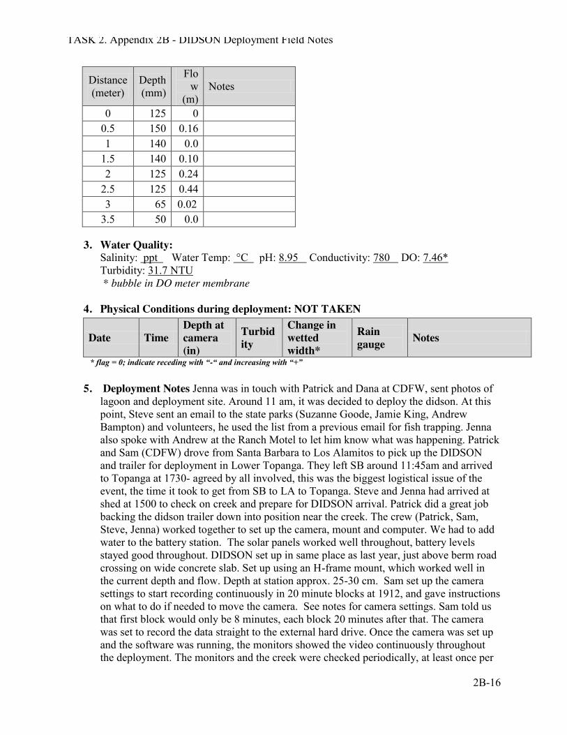
TASK 2. Appendix 2B - DIDSON Deployment Field Notes
2B-16
Distance (meter)
Depth (mm)
Flow
(m) Notes
0 125 0 0.5 150 0.16 1 140 0.0
1.5 140 0.10 2 125 0.24
2.5 125 0.44 3 65 0.02
3.5 50 0.0
3. Water Quality: Salinity: ppt Water Temp: °C pH: 8.95 Conductivity: 780 DO: 7.46* Turbidity: 31.7 NTU * bubble in DO meter membrane
4. Physical Conditions during deployment: NOT TAKEN
Date Time Depth at camera (in)
Turbidity
Change in wetted width*
Rain gauge Notes
* flag = 0; indicate receding with “-“ and increasing with “+”
5. Deployment Notes Jenna was in touch with Patrick and Dana at CDFW, sent photos of lagoon and deployment site. Around 11 am, it was decided to deploy the didson. At this point, Steve sent an email to the state parks (Suzanne Goode, Jamie King, Andrew Bampton) and volunteers, he used the list from a previous email for fish trapping. Jenna also spoke with Andrew at the Ranch Motel to let him know what was happening. Patrick and Sam (CDFW) drove from Santa Barbara to Los Alamitos to pick up the DIDSON and trailer for deployment in Lower Topanga. They left SB around 11:45am and arrived to Topanga at 1730- agreed by all involved, this was the biggest logistical issue of the event, the time it took to get from SB to LA to Topanga. Steve and Jenna had arrived at shed at 1500 to check on creek and prepare for DIDSON arrival. Patrick did a great job backing the didson trailer down into position near the creek. The crew (Patrick, Sam, Steve, Jenna) worked together to set up the camera, mount and computer. We had to add water to the battery station. The solar panels worked well throughout, battery levels stayed good throughout. DIDSON set up in same place as last year, just above berm road crossing on wide concrete slab. Set up using an H-frame mount, which worked well in the current depth and flow. Depth at station approx. 25-30 cm. Sam set up the camera settings to start recording continuously in 20 minute blocks at 1912, and gave instructions on what to do if needed to move the camera. See notes for camera settings. Sam told us that first block would only be 8 minutes, each block 20 minutes after that. The camera was set to record the data straight to the external hard drive. Once the camera was set up and the software was running, the monitors showed the video continuously throughout the deployment. The monitors and the creek were checked periodically, at least once per
TASK 2. Appendix 2B - DIDSON Deployment Field Notes
2B-17
hour, throughout the deployment for movement or flow. No movement was noted during the deployment.
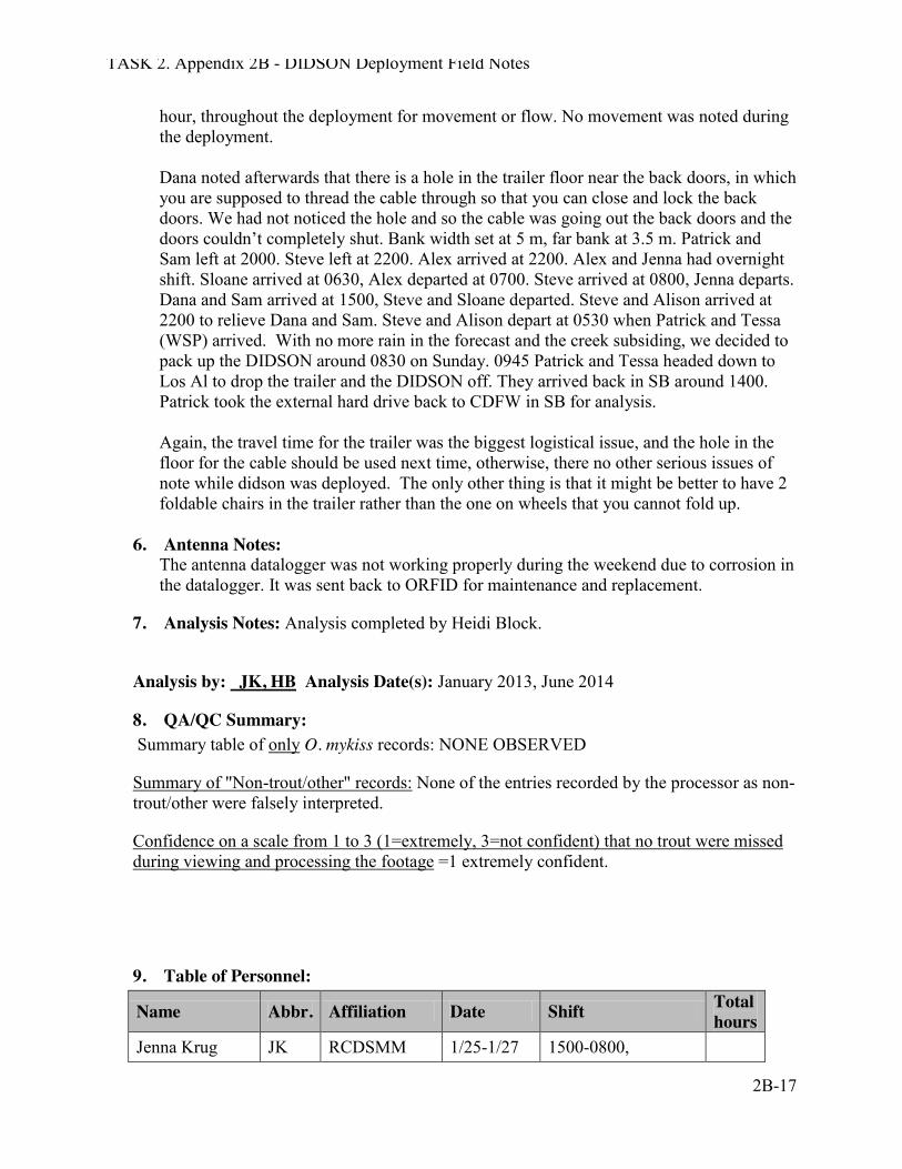
Dana noted afterwards that there is a hole in the trailer floor near the back doors, in which you are supposed to thread the cable through so that you can close and lock the back doors. We had not noticed the hole and so the cable was going out the back doors and the doors couldn’t completely shut. Bank width set at 5 m, far bank at 3.5 m. Patrick and Sam left at 2000. Steve left at 2200. Alex arrived at 2200. Alex and Jenna had overnight shift. Sloane arrived at 0630, Alex departed at 0700. Steve arrived at 0800, Jenna departs. Dana and Sam arrived at 1500, Steve and Sloane departed. Steve and Alison arrived at 2200 to relieve Dana and Sam. Steve and Alison depart at 0530 when Patrick and Tessa (WSP) arrived. With no more rain in the forecast and the creek subsiding, we decided to pack up the DIDSON around 0830 on Sunday. 0945 Patrick and Tessa headed down to Los Al to drop the trailer and the DIDSON off. They arrived back in SB around 1400. Patrick took the external hard drive back to CDFW in SB for analysis.
Again, the travel time for the trailer was the biggest logistical issue, and the hole in the floor for the cable should be used next time, otherwise, there no other serious issues of note while didson was deployed. The only other thing is that it might be better to have 2 foldable chairs in the trailer rather than the one on wheels that you cannot fold up.
6. Antenna Notes:
The antenna datalogger was not working properly during the weekend due to corrosion in the datalogger. It was sent back to ORFID for maintenance and replacement.
7. Analysis Notes: Analysis completed by Heidi Block.
Analysis by: JK, HB Analysis Date(s): January 2013, June 2014
8. QA/QC Summary: Summary table of only O. mykiss records: NONE OBSERVED
Summary of "Non-trout/other" records: None of the entries recorded by the processor as non-trout/other were falsely interpreted.
Confidence on a scale from 1 to 3 (1=extremely, 3=not confident) that no trout were missed during viewing and processing the footage =1 extremely confident.
9. Table of Personnel:
Name Abbr. Affiliation Date Shift Total hours
Jenna Krug JK RCDSMM 1/25-1/27 1500-0800,
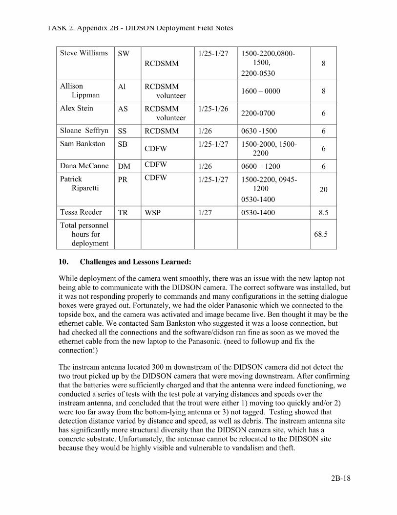
TASK 2. Appendix 2B - DIDSON Deployment Field Notes
2B-18
Steve Williams SW RCDSMM
1/25-1/27 1500-2200,0800-1500,
2200-0530 8
Allison Lippman
Al RCDSMM volunteer
1600 – 0000 8
Alex Stein AS RCDSMM volunteer
1/25-1/26 2200-0700 6
Sloane Seffryn SS RCDSMM 1/26 0630 -1500 6 Sam Bankston SB CDFW 1/25-1/27 1500-2000, 1500-
2200 6
Dana McCanne DM CDFW 1/26 0600 – 1200 6 Patrick
Riparetti PR CDFW 1/25-1/27 1500-2200, 0945-
1200 0530-1400
20
Tessa Reeder TR WSP 1/27 0530-1400 8.5 Total personnel
hours for deployment
68.5
10. Challenges and Lessons Learned:
While deployment of the camera went smoothly, there was an issue with the new laptop not being able to communicate with the DIDSON camera. The correct software was installed, but it was not responding properly to commands and many configurations in the setting dialogue boxes were grayed out. Fortunately, we had the older Panasonic which we connected to the topside box, and the camera was activated and image became live. Ben thought it may be the ethernet cable. We contacted Sam Bankston who suggested it was a loose connection, but had checked all the connections and the software/didson ran fine as soon as we moved the ethernet cable from the new laptop to the Panasonic. (need to followup and fix the connection!)
The instream antenna located 300 m downstream of the DIDSON camera did not detect the two trout picked up by the DIDSON camera that were moving downstream. After confirming that the batteries were sufficiently charged and that the antenna were indeed functioning, we conducted a series of tests with the test pole at varying distances and speeds over the instream antenna, and concluded that the trout were either 1) moving too quickly and/or 2) were too far away from the bottom-lying antenna or 3) not tagged. Testing showed that detection distance varied by distance and speed, as well as debris. The instream antenna site has significantly more structural diversity than the DIDSON camera site, which has a concrete substrate. Unfortunately, the antennae cannot be relocated to the DIDSON site because they would be highly visible and vulnerable to vandalism and theft.

TASK 2. Appendix 2B - DIDSON Deployment Field Notes
2B-19
Overall the deployment, monitoring and take down were successful and despite lack of sleep, all went very smoothly.
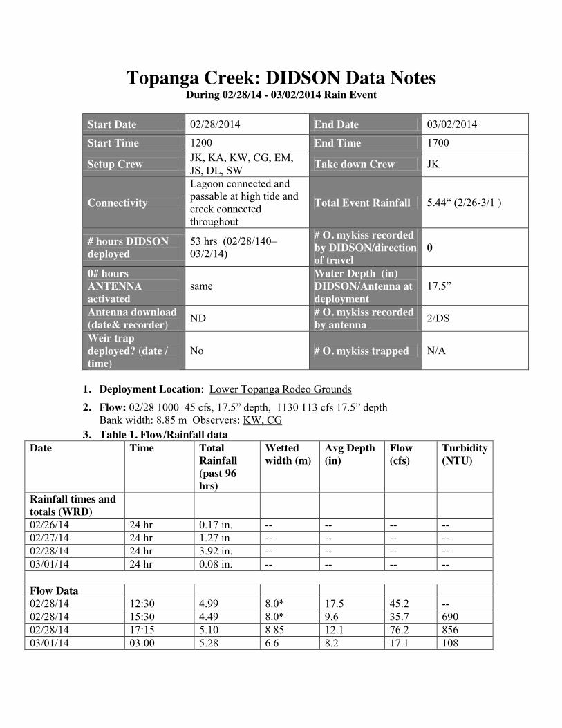
Topanga Creek: DIDSON Data Notes During 02/28/14 - 03/02/2014 Rain Event
Start Date 02/28/2014 End Date 03/02/2014
Start Time 1200 End Time 1700
Setup Crew JK, KA, KW, CG, EM, JS, DL, SW Take down Crew JK
Connectivity
Lagoon connected and passable at high tide and creek connected throughout
Total Event Rainfall 5.44“ (2/26-3/1 )
# hours DIDSON deployed
53 hrs (02/28/140–03/2/14)
# O. mykiss recorded by DIDSON/direction of travel
0
0# hours ANTENNA activated
same Water Depth (in) DIDSON/Antenna at deployment
17.5”
Antenna download (date& recorder) ND # O. mykiss recorded
by antenna 2/DS
Weir trap deployed? (date / time)
No # O. mykiss trapped N/A
1. Deployment Location: Lower Topanga Rodeo Grounds
2. Flow: 02/28 1000 45 cfs, 17.5” depth, 1130 113 cfs 17.5” depth Bank width: 8.85 m Observers: KW, CG
3. Table 1. Flow/Rainfall data Date Time Total
Rainfall (past 96 hrs)
Wetted width (m)
Avg Depth (in)
Flow (cfs)
Turbidity (NTU)
Rainfall times and totals (WRD)
02/26/14 24 hr 0.17 in. -- -- -- -- 02/27/14 24 hr 1.27 in -- -- -- -- 02/28/14 24 hr 3.92 in. -- -- -- -- 03/01/14 24 hr 0.08 in. -- -- -- -- Flow Data 02/28/14 12:30 4.99 8.0* 17.5 45.2 -- 02/28/14 15:30 4.49 8.0* 9.6 35.7 690 02/28/14 17:15 5.10 8.85 12.1 76.2 856 03/01/14 03:00 5.28 6.6 8.2 17.1 108
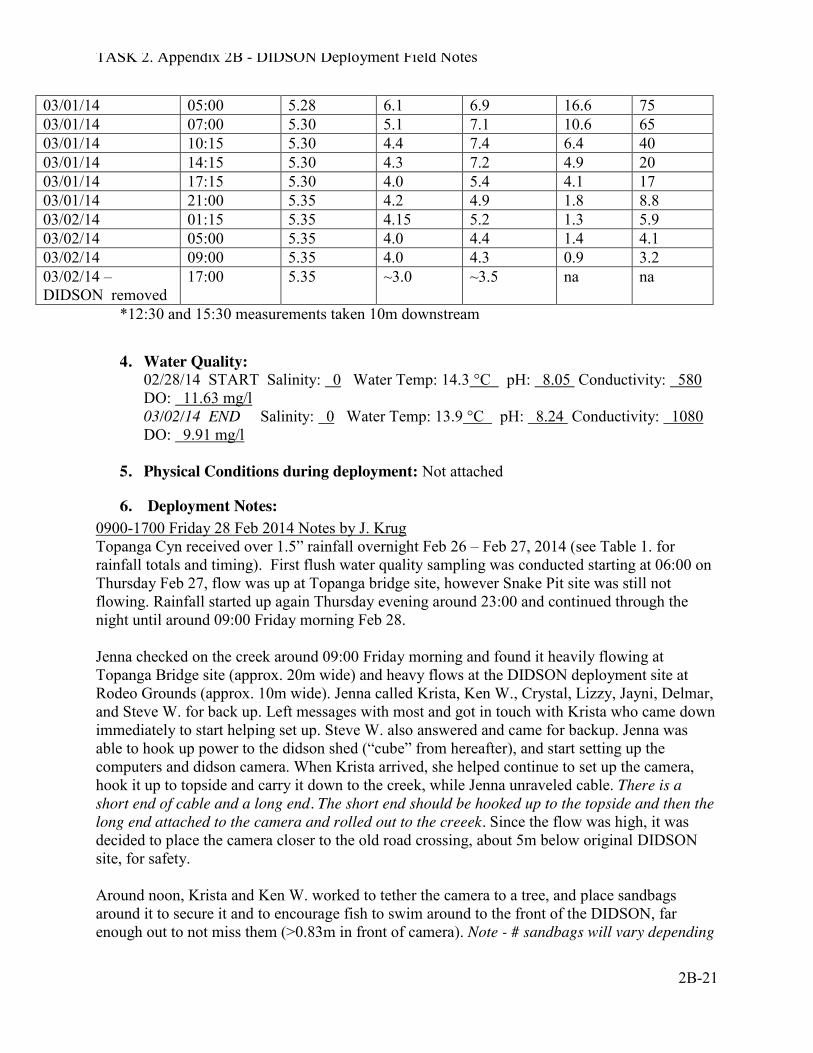
TASK 2. Appendix 2B - DIDSON Deployment Field Notes
2B-21
03/01/14 05:00 5.28 6.1 6.9 16.6 75 03/01/14 07:00 5.30 5.1 7.1 10.6 65 03/01/14 10:15 5.30 4.4 7.4 6.4 40 03/01/14 14:15 5.30 4.3 7.2 4.9 20 03/01/14 17:15 5.30 4.0 5.4 4.1 17 03/01/14 21:00 5.35 4.2 4.9 1.8 8.8 03/02/14 01:15 5.35 4.15 5.2 1.3 5.9 03/02/14 05:00 5.35 4.0 4.4 1.4 4.1 03/02/14 09:00 5.35 4.0 4.3 0.9 3.2 03/02/14 – DIDSON removed
17:00 5.35 ~3.0 ~3.5 na na
*12:30 and 15:30 measurements taken 10m downstream
4. Water Quality:
02/28/14 START Salinity: 0 Water Temp: 14.3 °C pH: 8.05 Conductivity: 580 DO: 11.63 mg/l 03/02/14 END Salinity: 0 Water Temp: 13.9 °C pH: 8.24 Conductivity: 1080 DO: 9.91 mg/l
5. Physical Conditions during deployment: Not attached
6. Deployment Notes: 0900-1700 Friday 28 Feb 2014 Notes by J. Krug Topanga Cyn received over 1.5” rainfall overnight Feb 26 – Feb 27, 2014 (see Table 1. for rainfall totals and timing). First flush water quality sampling was conducted starting at 06:00 on Thursday Feb 27, flow was up at Topanga bridge site, however Snake Pit site was still not flowing. Rainfall started up again Thursday evening around 23:00 and continued through the night until around 09:00 Friday morning Feb 28. Jenna checked on the creek around 09:00 Friday morning and found it heavily flowing at Topanga Bridge site (approx. 20m wide) and heavy flows at the DIDSON deployment site at Rodeo Grounds (approx. 10m wide). Jenna called Krista, Ken W., Crystal, Lizzy, Jayni, Delmar, and Steve W. for back up. Left messages with most and got in touch with Krista who came down immediately to start helping set up. Steve W. also answered and came for backup. Jenna was able to hook up power to the didson shed (“cube” from hereafter), and start setting up the computers and didson camera. When Krista arrived, she helped continue to set up the camera, hook it up to topside and carry it down to the creek, while Jenna unraveled cable. There is a short end of cable and a long end. The short end should be hooked up to the topside and then the long end attached to the camera and rolled out to the creeek. Since the flow was high, it was decided to place the camera closer to the old road crossing, about 5m below original DIDSON site, for safety. Around noon, Krista and Ken W. worked to tether the camera to a tree, and place sandbags around it to secure it and to encourage fish to swim around to the front of the DIDSON, far enough out to not miss them (>0.83m in front of camera). Note - # sandbags will vary depending
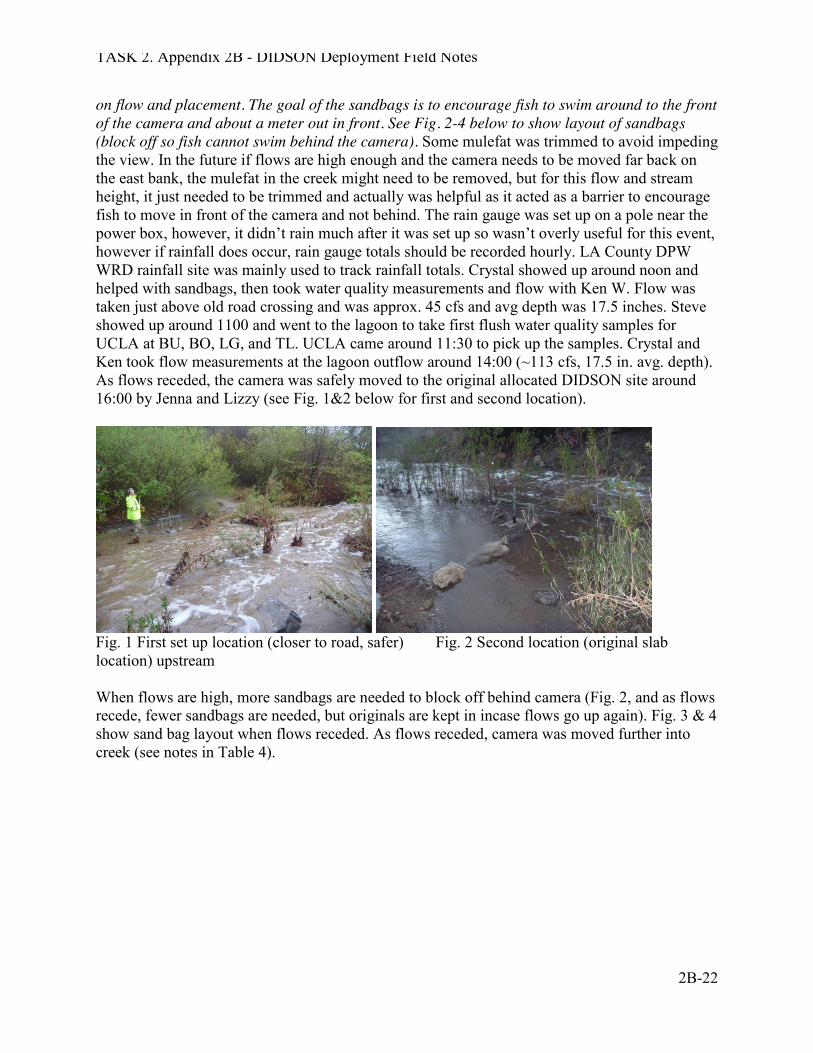
TASK 2. Appendix 2B - DIDSON Deployment Field Notes
2B-22
on flow and placement. The goal of the sandbags is to encourage fish to swim around to the front of the camera and about a meter out in front. See Fig. 2-4 below to show layout of sandbags (block off so fish cannot swim behind the camera). Some mulefat was trimmed to avoid impeding the view. In the future if flows are high enough and the camera needs to be moved far back on the east bank, the mulefat in the creek might need to be removed, but for this flow and stream height, it just needed to be trimmed and actually was helpful as it acted as a barrier to encourage fish to move in front of the camera and not behind. The rain gauge was set up on a pole near the power box, however, it didn’t rain much after it was set up so wasn’t overly useful for this event, however if rainfall does occur, rain gauge totals should be recorded hourly. LA County DPW WRD rainfall site was mainly used to track rainfall totals. Crystal showed up around noon and helped with sandbags, then took water quality measurements and flow with Ken W. Flow was taken just above old road crossing and was approx. 45 cfs and avg depth was 17.5 inches. Steve showed up around 1100 and went to the lagoon to take first flush water quality samples for UCLA at BU, BO, LG, and TL. UCLA came around 11:30 to pick up the samples. Crystal and Ken took flow measurements at the lagoon outflow around 14:00 (~113 cfs, 17.5 in. avg. depth). As flows receded, the camera was safely moved to the original allocated DIDSON site around 16:00 by Jenna and Lizzy (see Fig. 1&2 below for first and second location).
Fig. 1 First set up location (closer to road, safer) Fig. 2 Second location (original slab location) upstream When flows are high, more sandbags are needed to block off behind camera (Fig. 2, and as flows recede, fewer sandbags are needed, but originals are kept in incase flows go up again). Fig. 3 & 4 show sand bag layout when flows receded. As flows receded, camera was moved further into creek (see notes in Table 4).
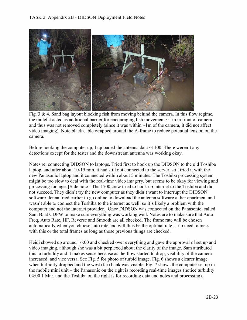
TASK 2. Appendix 2B - DIDSON Deployment Field Notes
2B-23
Fig. 3 & 4. Sand bag layout blocking fish from moving behind the camera. In this flow regime, the mulefat acted as additional barrier for encouraging fish movement ~ 1m in front of camera and thus was not removed completely (since it was within ~1m of the camera, it did not affect video imaging). Note black cable wrapped around the A-frame to reduce potential tension on the camera. Before hooking the computer up, I uploaded the antenna data ~1100. There weren’t any detections except for the tester and the downstream antenna was working okay. Notes re: connecting DIDSON to laptops. Tried first to hook up the DIDSON to the old Toshiba laptop, and after about 10-15 min, it had still not connected to the server, so I tried it with the new Panasonic laptop and it connected within about 5 minutes. The Toshiba processing system might be too slow to deal with the real-time video imagery, but seems to be okay for viewing and processing footage. [Side note - The 1700 crew tried to hook up internet to the Toshiba and did not succeed. They didn’t try the new computer as they didn’t want to interrupt the DIDSON software. Jenna tried earlier to go online to download the antenna software at her apartment and wasn’t able to connect the Toshiba to the internet as well, so it’s likely a problem with the computer and not the internet provider.] Once DIDSON was connected on the Panasonic, called Sam B. at CDFW to make sure everything was working well. Notes are to make sure that Auto Freq, Auto Rate, HF, Reverse and Smooth are all checked. The frame rate will be chosen automatically when you choose auto rate and will thus be the optimal rate… no need to mess with this or the total frames as long as those previous things are checked. Heidi showed up around 16:00 and checked over everything and gave the approval of set up and video imaging, although she was a bit perplexed about the clarity of the image. Sam attributed this to turbidity and it makes sense because as the flow started to drop, visibility of the camera increased, and vice versa. See Fig. 5 for photo of turbid image. Fig. 6 shows a clearer image when turbidity dropped and the west (far) bank was visible. Fig. 7 shows the computer set up in the mobile mini unit – the Panasonic on the right is recording real-time images (notice turbidity 04:00 1 Mar, and the Toshiba on the right is for recording data and notes and processing).
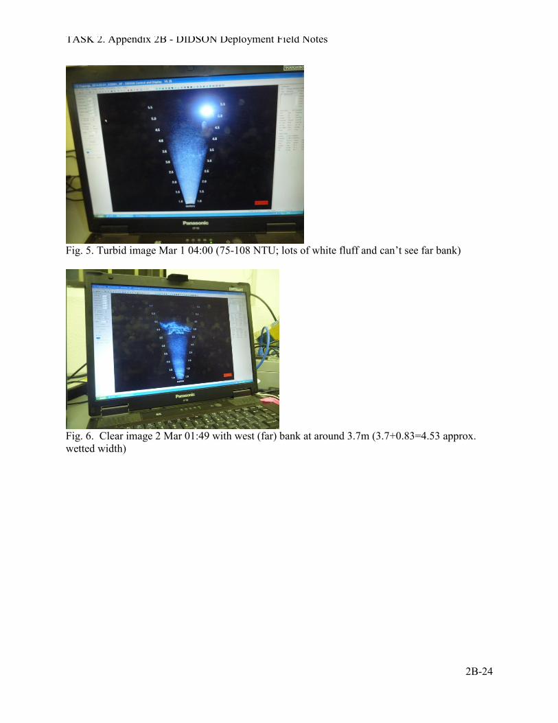
TASK 2. Appendix 2B - DIDSON Deployment Field Notes
2B-24
Fig. 5. Turbid image Mar 1 04:00 (75-108 NTU; lots of white fluff and can’t see far bank)
Fig. 6. Clear image 2 Mar 01:49 with west (far) bank at around 3.7m (3.7+0.83=4.53 approx. wetted width)
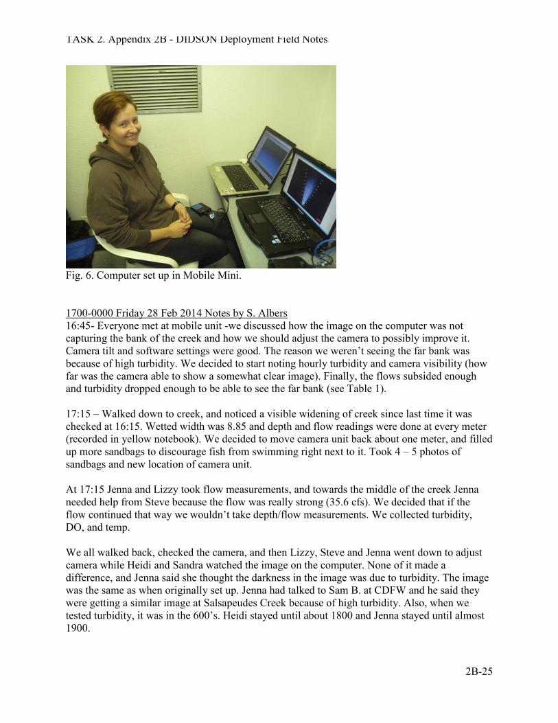
TASK 2. Appendix 2B - DIDSON Deployment Field Notes
2B-25
Fig. 6. Computer set up in Mobile Mini. 1700-0000 Friday 28 Feb 2014 Notes by S. Albers 16:45- Everyone met at mobile unit -we discussed how the image on the computer was not capturing the bank of the creek and how we should adjust the camera to possibly improve it. Camera tilt and software settings were good. The reason we weren’t seeing the far bank was because of high turbidity. We decided to start noting hourly turbidity and camera visibility (how far was the camera able to show a somewhat clear image). Finally, the flows subsided enough and turbidity dropped enough to be able to see the far bank (see Table 1). 17:15 – Walked down to creek, and noticed a visible widening of creek since last time it was checked at 16:15. Wetted width was 8.85 and depth and flow readings were done at every meter (recorded in yellow notebook). We decided to move camera unit back about one meter, and filled up more sandbags to discourage fish from swimming right next to it. Took 4 – 5 photos of sandbags and new location of camera unit. At 17:15 Jenna and Lizzy took flow measurements, and towards the middle of the creek Jenna needed help from Steve because the flow was really strong (35.6 cfs). We decided that if the flow continued that way we wouldn’t take depth/flow measurements. We collected turbidity, DO, and temp. We all walked back, checked the camera, and then Lizzy, Steve and Jenna went down to adjust camera while Heidi and Sandra watched the image on the computer. None of it made a difference, and Jenna said she thought the darkness in the image was due to turbidity. The image was the same as when originally set up. Jenna had talked to Sam B. at CDFW and he said they were getting a similar image at Salsapeudes Creek because of high turbidity. Also, when we tested turbidity, it was in the 600’s. Heidi stayed until about 1800 and Jenna stayed until almost 1900.
TASK 2. Appendix 2B - DIDSON Deployment Field Notes
2B-26
2030 Friday 28 Feb 2104 Notes by S. Williams Met Jenna at DIDSON shed at 1100. Then went to motel office to pick up water bottles for beach grab samples. Grabbed samples at Beach Upper, Lagoon, Berm Opening, and Lifeguard Station. Berm open; very low tide; lagoon drained. Water turbid, brown. All samples brown except Beach Upper. Met Amy at shed to transfer samples to her cooler. Samples collected between 1150 and 1225. She got the bridge sample. Returned to DIDSON camp. Went with Jenna to check flow at fish camp, and get extra didson shed keys made. Swift flow; creek full. Back to DIDSON; we looked at weather and decided to prepare for possible fish trap deployment for this evening. Crystal and I went to shed and loaded the traps into my van. We unloaded at end of fish camp road. Jenna, Heidi (stopped by to visit enroute back from work) and Lizzie joined us in moving traps to camp. Once there we all re-assessed trapping then versus waiting until am. Since heavy rains were predicted for “morning”, and the flow was still swift, we decided to wait till the next heavy pulse cleared in the am, and creek was safe for deployment. We left the traps near the creek for the night. Rosi called in and confirmed that traps should be deployed following the last pulse of rain if at all. 1700 Back at DIDSON, we tried adjusting the camera to see if we could pick up more visibility by raising or lowering the lens. There was some discussion that it might not be pointed straight, so we were not seeing the other bank…just blackout after about 3.5-4m. We tried the up and down adjustments, in communication with shed by walkie talkie. No improvement noted. Current theory is that turbidity is so high, that we cannot get a read all the way across creek. We collected flow data, turbidity, and DO. Jenna and Lizzy had a bit of a time crossing creek safely with equipment; decided not to do flow again until it drops and feels safe, especially at night. Hourly creek checks with turbidity and DO. We set a ceramic wetted edge marker at 1700; level has dropped and risen, then dropped since then. Been dry for last couple hours. 00:00 1 Mar – 17:00 2 Mar 2014 Camera kept in overnight Feb 28-Mar 1, and Mar 1-2, and shut down around 17:00 on March 2. Every hour or so, 2 people walked down to check on the camera, the water level, and take appropriate data (flow, water quality, turbidity). Turbidity, dissolved oxygen, water and air temperatures, rainfall totals (from the LA County DPW WRD website), camera visibility and any other interesting notes were taken. Water quality measurements, wetted width and flow were taken when seemed appropriate (when safe and when there was a big change or every few hours). Photos were taken often as well. Hourly data and notes were recorded into an EXCEL spreadsheet throughout the deployment (Table 4). See Table 3 for details on personnel and shift changes. Flow (and turbidity) continued to decrease throughout the time. We were expecting another bought of rain on Mar 1 that never showed. Flows continued to decline overnight on the 1st and dropped fairly quickly in the early morning to afternoon on the 2nd. We checked and monitored the lagoon at high and low tides as well. Heidi came around 11:00 on Mar 2 to review and try to start processing with Heidi and Krista (see data book notes for more information on that). Heidi, Steve, and Jenna removed camera and cleaned up around 17:00, flow low and wetted width about 3m, depth at antenna approx. 10cm.
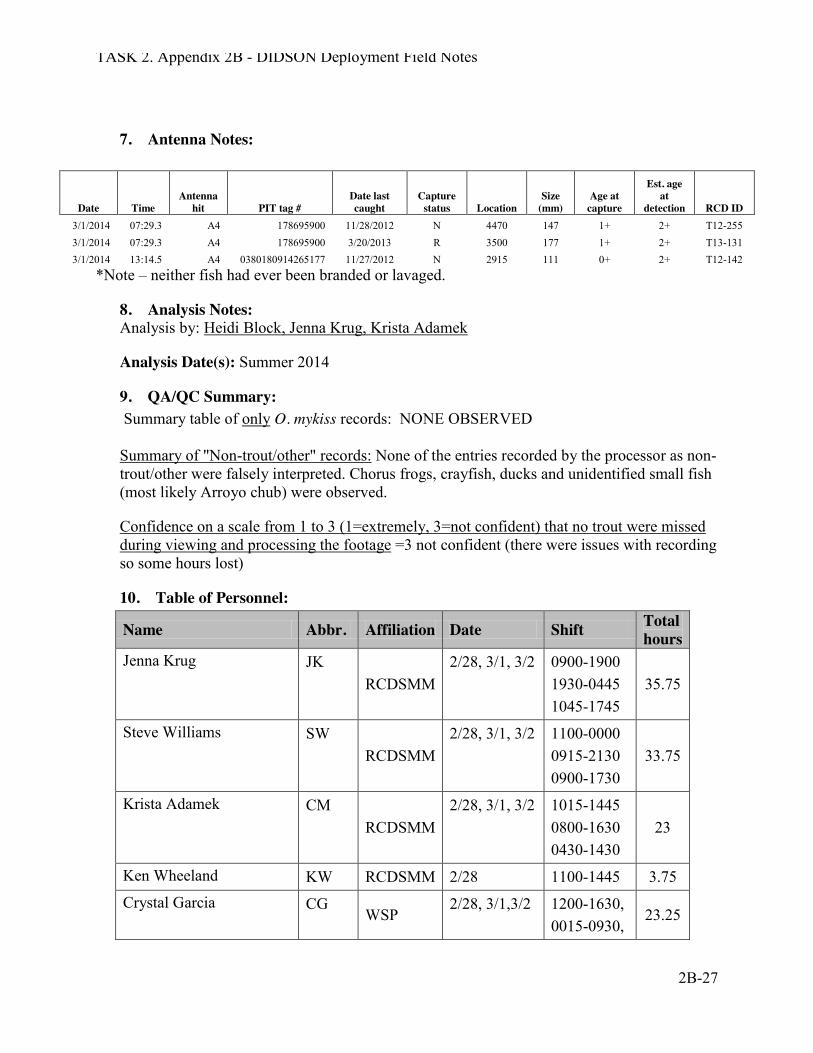
TASK 2. Appendix 2B - DIDSON Deployment Field Notes
2B-27
7. Antenna Notes:
Date Time Antenna
hit PIT tag # Date last caught
Capture status Location
Size (mm)
Age at capture
Est. age at
detection RCD ID 3/1/2014 07:29.3 A4 178695900 11/28/2012 N 4470 147 1+ 2+ T12-255 3/1/2014 07:29.3 A4 178695900 3/20/2013 R 3500 177 1+ 2+ T13-131 3/1/2014 13:14.5 A4 0380180914265177 11/27/2012 N 2915 111 0+ 2+ T12-142
*Note – neither fish had ever been branded or lavaged.
8. Analysis Notes: Analysis by: Heidi Block, Jenna Krug, Krista Adamek
Analysis Date(s): Summer 2014
9. QA/QC Summary: Summary table of only O. mykiss records: NONE OBSERVED Summary of "Non-trout/other" records: None of the entries recorded by the processor as non-trout/other were falsely interpreted. Chorus frogs, crayfish, ducks and unidentified small fish (most likely Arroyo chub) were observed.
Confidence on a scale from 1 to 3 (1=extremely, 3=not confident) that no trout were missed during viewing and processing the footage =3 not confident (there were issues with recording so some hours lost)
10. Table of Personnel:
Name Abbr. Affiliation Date Shift Total hours
Jenna Krug JK RCDSMM
2/28, 3/1, 3/2 0900-1900 1930-0445 1045-1745
35.75
Steve Williams SW RCDSMM
2/28, 3/1, 3/2 1100-0000 0915-2130 0900-1730
33.75
Krista Adamek CM RCDSMM
2/28, 3/1, 3/2 1015-1445 0800-1630 0430-1430
23
Ken Wheeland KW RCDSMM 2/28 1100-1445 3.75 Crystal Garcia CG
WSP 2/28, 3/1,3/2 1200-1630,
0015-0930, 23.25
TASK 2. Appendix 2B - DIDSON Deployment Field Notes
2B-28
0000-0930 Lizzy Montgomery LM WSP 2/28,3/1 1415-0030
2100-0515 18.5
Jayni Shuman JS RCDSMM 3/1 1600-2100 5 Heidi Block HB CDFW 2/28, 3/2 1600-1800
1100-1700 8
Sandra Albers SA RCDSMM 2/28 1645-2345 7 Amanda Rosenblum AB RCDSMM 3/1 0000-0830 8.5 Total personnel hours for
deployment 166.5
11. Challenges and Lessons Learned: Lessons Learned Issue with file saving: We had an issue with the date on the file name not automatically updating (so duplicate file names were being made and saved onto the recording drive). When the recording external drive was plugged in, it appeared that it was still saving all files regardless of duplicates (based on date last modified – all dates and times were there). The problem occurred when we unplugged the recording drive at the end of the event. When plugged back in to check and backup all data, the duplicate file names from the earlier date had been deleted. Talked to Sam at CDFW and he is also unsure about why they would have been deleted. Jenna checked into file recovery and is using Stellar Phoenix Photo Recovery to attempt to recover the lost files, no luck. Ways to avoid this issue in the future:
1) when setting save directory, open save file location and press save, don’t add anything to the file name in case it affects file saving ability
2) file name example: 2014-02-28_121018_HF.ddf 3) transfer all files from recording external drive to another drive every 6 hours, each time
putting it into its own folder named with the date and time of transfer 4) should check every hour to make sure it is properly recording to the external drive, and
time and date stamps are correct Other notes for future events:
1) Might want to consider moving set up location closer to road crossing. In high flows, it is unsafe to walk that far upstream to the location with the concrete slab. Note- in those high flows, water is generally too turbid to see much on the camera.
2) Turbidity affects the visibility of the didson camera such that when flows are really high and water is very turbid (like in a first flush or turbid stream), you won’t be able to get really clear images from the DIDSON. We noticed that when we first deployed, the image was very grainy and had a lot of “static” which seemed likely to be a factor of turbidity, because as turbidity (and flows) decreased, the “visibility” of the camera (how far you could see a good image on the screen) increased.
TASK 2. Appendix 2B - DIDSON Deployment Field Notes
2B-29
3) The cable connecting the didson to the computer is very long and thus it takes a good few minutes for the didson to show that it has connected with the computer (just be patient). If it’s been ten minutes and there is still no connection, something might be wrong – check all connections and power.
4) When the auto rate/auto frequency boxes are checked, and HF is selected, the program will choose the optimal frame rate for the data. You don’t need to change this. You can change it if it seems reasonable, and if you change it to something too high or too low, as long as the auto boxes are checked, it will be changed back automatically. Changing frame rates doesn’t seem to affect image recording.
5) When you disconnect the recording hard drive, you lose the remainder of the 20 min. segment, you also have to shut down the system and software and restart. When transferring files from one hard drive to another, make sure to disconnect the correct hard drive (you can check which one it is recording on by figuring out which one has a file being currently written if you are unsure). They are also labeled 1 and 2
6) When possible, turbidity measurements should be taken especially when flows are high and the image is blurry (also turbidity can be used as a proxy for flow).
7) If it is unsafe to take a full transect flow measurement, try to get at least one flow measurement, and estimate average depth and wetted width that can be used to estimate flow (cfs). DO NOT take flow if you feel it is unsafe to do so. If flows are high but safe enough for taking flow, make sure to be wearing a life vest and head lamp.
8) Full water quality measurements (DO, pH, conductivity, salinity, flow, turbidity) at the start of each event, once per day following, and at the end of each deployment?
9) Data sheets! We should print up some data sheets for field data and for processing, print on waterproof paper and keep on clipboard.
10) Set up a WORD document at the beginning of the deployment with suggested notes to be taken during each shift. Notes should include shift times and personnel at a minimum and should be typed into the word document throughout.
11) Set up an EXCEL spreadsheet for hourly data. Record on data sheet and into spreadsheet as you go.

TASK 2. Appendix 2B - DIDSON Deployment Field Notes
2B-30
Topanga Creek: DIDSON Data Notes During 03/06/16 - 03/07/2016 Rain Event
Start Date 03/06/16 End Date 03/07/16 Start Time 16:00 End Time 12:45 Setup Crew RD, KA, BC, DH Take down Crew SW, DH, RD
Connectivity
Lagoon connected and passable at high tide and creek connected throughout
Total Event Rainfall 3.4" (Mar 05-7)
# hours DIDSON deployed
17 hrs 20 mins (3/6/16 18:00 – 3/7/16 11:20)
# O. mykiss recorded by DIDSON/direction of travel
2/DS
# hours ANTENNA activated
same Water Depth (in) DIDSON/Antenna at deployment
10"/10”
Antenna download (date& recorder) 03/07/16 DH # O. mykiss recorded
by antenna 0
Weir trap deployed? (date / time)
No # O. mykiss trapped N/A
1. Deployment Location: Lower Topanga Rodeo Grounds
2. Flow: Date: 3/6/16 Time: 1620 Bank width: 17.7’ Observers: RD, DH
Distance (ft)
Depth (in)
Flow (ft/s) Notes Distance
(ft) Depth (in)
Flow (ft/s) Notes
0 2.0 0 10 9.5 0.31 2 7 0.1 12 8.75 0 behind rock baffles 4 9.5 0.89 14 6.25 0.02 6 9.75 1.14 16 3.75 0 8 9.5 0.95 18 0.3 0
3. Water Quality: Salinity: 0ppt Water Temp: 14.9°C pH: 8.95 Conductivity: 780 DO: 7.46* Turbidity: 31.7 NTU * bubble in DO meter membrane
4. Physical Conditions during deployment: Date Time Depth at Turbid Change in Rain Notes
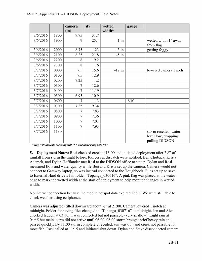
TASK 2. Appendix 2B - DIDSON Deployment Field Notes
2B-31
camera (in)
ity wetted width*
gauge
3/6/2016 1800 9.75 31.7 3/6/2016 1900 9 25.1 -1 in wetted width 1" away
from flag 3/6/2016 2000 8.75 23 -3 in getting foggy! 3/6/2016 2100 8.25 21.8 -5 in 3/6/2016 2200 8 19.2 3/6/2016 2300 8 16 3/7/2016 0000 7.5 15.6 -12 in lowered camera 1 inch 3/7/2016 0100 7.5 12.9 3/7/2016 0200 7.25 11.2 3/7/2016 0300 7 12.6 3/7/2016 0400 7 11.19 3/7/2016 0500 6.95 10.9 3/7/2016 0600 7 11.3 2/10 3/7/2016 0700 7.25 9.34 3/7/2016 0800 7 7.83 3/7/2016 0900 7 7.36 3/7/2016 1000 7 7.01 3/7/2016 1100 7 7.93 3/7/2016 1130 storm receded; water
level low, dropping. pulling DIDSON
* flag = 0; indicate receding with “-“ and increasing with “+”
5. Deployment Notes: Rosi checked creek at 13:00 and initiated deployment after 2.8” of rainfall from storm the night before. Rangers at dispatch were notified. Ben Chuback, Krista Adamek, and Dylan Hofflander met Rosi at the DIDSON office to set up. Dylan and Rosi measured flow and water quality while Ben and Krista set up the camera. Camera would not connect to Gateway laptop, so was instead connected to the Toughbook. Files set up to save to External Hard drive #1 in folder “Topanga_030616”. A pink flag was placed at the water edge to mark the wetted width at the start of deployment to help monitor changes in wetted width.
No internet connection because the mobile hotspot data expired Feb 6. We were still able to check weather using cellphones.
Camera was adjusted (tilted downward about ½” at 21:00. Camera lowered 1 notch at midnight. Folder for saving files changed to “Topanga_030716” at midnight. Jen and Alex checked lagoon at 03:30; it was connected but not passable (very shallow). Light rain at 04:45 but main storm did not arrive until 06:00. 06:00 storm brought brief heavy rain and passed quickly. By 11:00 storm completely receded, sun was out, and creek not passable for most fish. Rosi called at 11:15 and initiated shut down. Dylan and Steve disconnected camera
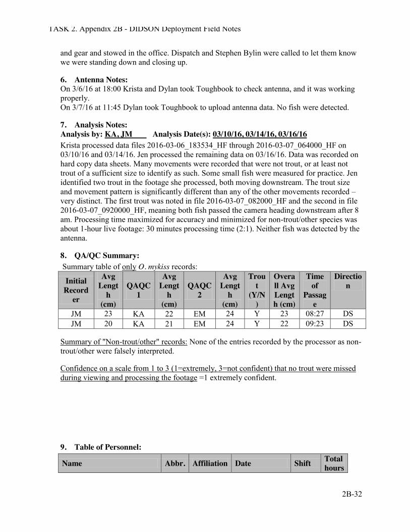
TASK 2. Appendix 2B - DIDSON Deployment Field Notes
2B-32
and gear and stowed in the office. Dispatch and Stephen Bylin were called to let them know we were standing down and closing up.
6. Antenna Notes: On 3/6/16 at 18:00 Krista and Dylan took Toughbook to check antenna, and it was working properly. On 3/7/16 at 11:45 Dylan took Toughbook to upload antenna data. No fish were detected.
7. Analysis Notes: Analysis by: KA, JM Analysis Date(s): 03/10/16, 03/14/16, 03/16/16 Krista processed data files 2016-03-06_183534_HF through 2016-03-07_064000_HF on 03/10/16 and 03/14/16. Jen processed the remaining data on 03/16/16. Data was recorded on hard copy data sheets. Many movements were recorded that were not trout, or at least not trout of a sufficient size to identify as such. Some small fish were measured for practice. Jen identified two trout in the footage she processed, both moving downstream. The trout size and movement pattern is significantly different than any of the other movements recorded – very distinct. The first trout was noted in file 2016-03-07_082000_HF and the second in file 2016-03-07_0920000_HF, meaning both fish passed the camera heading downstream after 8 am. Processing time maximized for accuracy and minimized for non-trout/other species was about 1-hour live footage: 30 minutes processing time (2:1). Neither fish was detected by the antenna.
8. QA/QC Summary: Summary table of only O. mykiss records:
Initial Record
er
Avg Lengt
h (cm)
QAQC1
Avg Lengt
h (cm)
QAQC2
Avg Lengt
h (cm)
Trout
(Y/N)
Overall Avg Length (cm)
Time of
Passage
Direction
JM 23 KA 22 EM 24 Y 23 08:27 DS JM 20 KA 21 EM 24 Y 22 09:23 DS
Summary of "Non-trout/other" records: None of the entries recorded by the processor as non-trout/other were falsely interpreted.
Confidence on a scale from 1 to 3 (1=extremely, 3=not confident) that no trout were missed during viewing and processing the footage =1 extremely confident.
9. Table of Personnel:
Name Abbr. Affiliation Date Shift Total hours
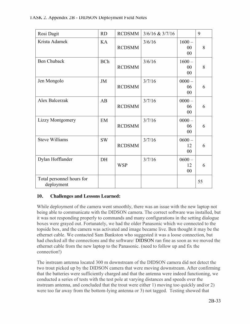
TASK 2. Appendix 2B - DIDSON Deployment Field Notes
2B-33
Rosi Dagit RD RCDSMM 3/6/16 & 3/7/16 9 Krista Adamek KA
RCDSMM 3/6/16 1600 –
0000
8
Ben Chuback BCh RCDSMM
3/6/16 1600 – 0000
8
Jen Mongolo JM RCDSMM
3/7/16 0000 – 0600
6
Alex Balcerzak AB RCDSMM
3/7/16 0000 – 0600
6
Lizzy Montgomery EM RCDSMM
3/7/16 0000 – 0600
6
Steve Williams SW RCDSMM
3/7/16 0600 – 1200
6
Dylan Hofflander DH WSP
3/7/16 0600 – 1200
6
Total personnel hours for deployment
55
10. Challenges and Lessons Learned:
While deployment of the camera went smoothly, there was an issue with the new laptop not being able to communicate with the DIDSON camera. The correct software was installed, but it was not responding properly to commands and many configurations in the setting dialogue boxes were grayed out. Fortunately, we had the older Panasonic which we connected to the topside box, and the camera was activated and image became live. Ben thought it may be the ethernet cable. We contacted Sam Bankston who suggested it was a loose connection, but had checked all the connections and the software/ DIDSON ran fine as soon as we moved the ethernet cable from the new laptop to the Panasonic. (need to follow up and fix the connection!)
The instream antenna located 300 m downstream of the DIDSON camera did not detect the two trout picked up by the DIDSON camera that were moving downstream. After confirming that the batteries were sufficiently charged and that the antenna were indeed functioning, we conducted a series of tests with the test pole at varying distances and speeds over the instream antenna, and concluded that the trout were either 1) moving too quickly and/or 2) were too far away from the bottom-lying antenna or 3) not tagged. Testing showed that
TASK 2. Appendix 2B - DIDSON Deployment Field Notes
2B-34
detection distance varied by distance and speed, as well as debris. The instream antenna site has significantly more structural diversity than the DIDSON camera site, which has a concrete substrate. Unfortunately, the antennae cannot be relocated to the DIDSON site because they would be highly visible and vulnerable to vandalism and theft.
Overall the deployment, monitoring and take down were successful and despite lack of sleep, all went very smoothly.
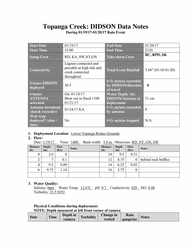
Topanga Creek: DIDSON Data Notes During 01/19/17-01/20/17 Rain Event
Start Date 01/19/17 End Date 01/20/17 Start Time 15:00 End Time 2130
Setup Crew RD, KA, SW,NT,GN Take down Crew BC, RPD, SK,RPD, SKBDC,SK,RPD
Connectivity
Lagoon connected and passable at high tide and creek connected throughout
Total Event Rainfall 3.68" (01/18-01/20)
# hours DIDSON deployed 30.5
# O. mykiss recorded by DIDSON/direction of travel
00
# hours ANTENNA activated
On: 01/18/17 Blew out in flood 1100 01/21/17
Water Depth (in) DIDSON/Antenna at deployment
31 cm
Antenna download (date& recorder) 01/24/17 KA # O. mykiss recorded
by antenna 0
Weir trap deployed? (date / time)
No # O. mykiss trapped N/A
1. Deployment Location: Lower Topanga Rodeo Grounds 2. Flow:
Date: 1/19/17 Time: 1400 Bank width: 5.9 m Observers: RD, NT, GN, SW Distance (ft)
Depth (in)
Flow (ft/s) Notes Distance
(ft) Depth (in)
Flow (ft/s) Notes
0 2.0 0 10 9.5 0.31 2 7 0.1 12 8.75 0 behind rock baffles 4 9.5 0.89 14 6.25 0.02 6 9.75 1.14 16 3.75 0
3. Water Quality: Salinity: 0ppt Water Temp: 12.6°C pH: 9.7 Conductivity: 820 DO: 8.98 Turbidity: 21.5 NTU
Physical Conditions during deployment: NOTE: Depth measured at left front corner of camera
Date Time Depth at camera Turbidity Change in
wetted Rain
gauge(in) Notes
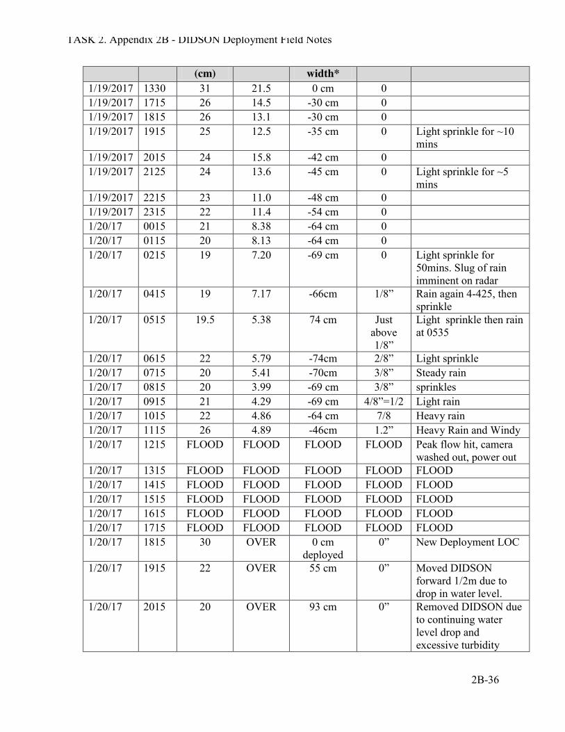
TASK 2. Appendix 2B - DIDSON Deployment Field Notes
2B-36
(cm) width* 1/19/2017 1330 31 21.5 0 cm 0 1/19/2017 1715 26 14.5 -30 cm 0 1/19/2017 1815 26 13.1 -30 cm 0 1/19/2017 1915 25 12.5 -35 cm 0 Light sprinkle for ~10
mins 1/19/2017 2015 24 15.8 -42 cm 0 1/19/2017 2125 24 13.6 -45 cm 0 Light sprinkle for ~5
mins 1/19/2017 2215 23 11.0 -48 cm 0 1/19/2017 2315 22 11.4 -54 cm 0 1/20/17 0015 21 8.38 -64 cm 0 1/20/17 0115 20 8.13 -64 cm 0 1/20/17 0215 19 7.20 -69 cm 0 Light sprinkle for
50mins. Slug of rain imminent on radar
1/20/17 0415 19 7.17 -66cm 1/8” Rain again 4-425, then sprinkle
1/20/17 0515 19.5 5.38 74 cm Just above 1/8”
Light sprinkle then rain at 0535
1/20/17 0615 22 5.79 -74cm 2/8” Light sprinkle 1/20/17 0715 20 5.41 -70cm 3/8” Steady rain 1/20/17 0815 20 3.99 -69 cm 3/8” sprinkles 1/20/17 0915 21 4.29 -69 cm 4/8”=1/2 Light rain 1/20/17 1015 22 4.86 -64 cm 7/8 Heavy rain 1/20/17 1115 26 4.89 -46cm 1.2” Heavy Rain and Windy 1/20/17 1215 FLOOD FLOOD FLOOD FLOOD Peak flow hit, camera
washed out, power out 1/20/17 1315 FLOOD FLOOD FLOOD FLOOD FLOOD 1/20/17 1415 FLOOD FLOOD FLOOD FLOOD FLOOD 1/20/17 1515 FLOOD FLOOD FLOOD FLOOD FLOOD 1/20/17 1615 FLOOD FLOOD FLOOD FLOOD FLOOD 1/20/17 1715 FLOOD FLOOD FLOOD FLOOD FLOOD 1/20/17 1815 30 OVER 0 cm
deployed 0” New Deployment LOC
1/20/17 1915 22 OVER 55 cm 0” Moved DIDSON forward 1/2m due to drop in water level.
1/20/17 2015 20 OVER 93 cm 0” Removed DIDSON due to continuing water level drop and excessive turbidity
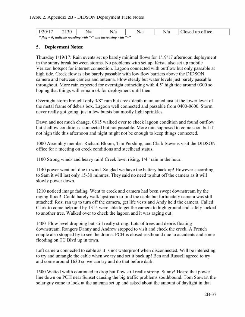
TASK 2. Appendix 2B - DIDSON Deployment Field Notes
2B-37
1/20/17 2130 N/a N/a N/a N/a Closed up office. * flag = 0; indicate receding with “-“ and increasing with “+”
5. Deployment Notes:
Thursday 1/19/17: Rain events set up barely minimal flows for 1/19/17 afternoon deployment in the sunny break between storms. No problems with set up. Krista also set up mobile Verizon hotspot for internet connection. Lagoon connected with outflow but only passable at high tide. Creek flow is also barely passable with low flow barriers above the DIDSON camera and between camera and antenna. Flow steady but water levels just barely passable throughout. More rain expected for overnight coinciding with 4.5’ high tide around 0300 so hoping that things will remain ok for deployment until then.
Overnight storm brought only 3/8” rain but creek depth maintained just at the lower level of the metal frame of debris box. Lagoon well connected and passable from 0400-0600. Storm never really got going, just a few bursts but mostly light sprinkles.
Dawn and not much change. 0815 walked over to check lagoon condition and found outflow but shallow conditions- connected but not passable. More rain supposed to come soon but if not high tide this afternoon and night might not be enough to keep things connected.
1000 Assembly member Richard Bloom, Tim Pershing, and Clark Stevens visit the DIDSON office for a meeting on creek conditions and steelhead status.
1100 Strong winds and heavy rain! Creek level rising, 1/4” rain in the hour.
1140 power went out due to wind. So glad we have the battery back up! However according to Sam it will last only 15-30 minutes. They said no need to shut off the camera as it will slowly power down.
1210 noticed image fading. Went to creek and camera had been swept downstream by the raging flood! Could barely walk upstream to find the cable but fortunately camera was still attached! Rosi ran up to turn off the camera, get life vests and Andy held the camera. Called Clark to come help and by 1315 were able to get the camera to high ground and safely locked to another tree. Walked over to check the lagoon and it was raging out!
1400 Flow level dropping but still really strong. Lots of trees and debris floating downstream. Rangers Danny and Andrew stopped to visit and check the creek. A French couple also stopped by to see the drama. PCH is closed eastbound due to accidents and some flooding on TC Blvd up in town.
Left camera connected to cable as it is not waterproof when disconnected. Will be interesting to try and untangle the cable when we try and set it back up! Ben and Russell agreed to try and come around 1630 so we can try and do that before dark.
1500 Wetted width continued to drop but flow still really strong. Sunny! Heard that power line down on PCH near Sunset causing the big traffic problems southbound. Tom Stewart the solar guy came to look at the antenna set up and asked about the amount of daylight in that
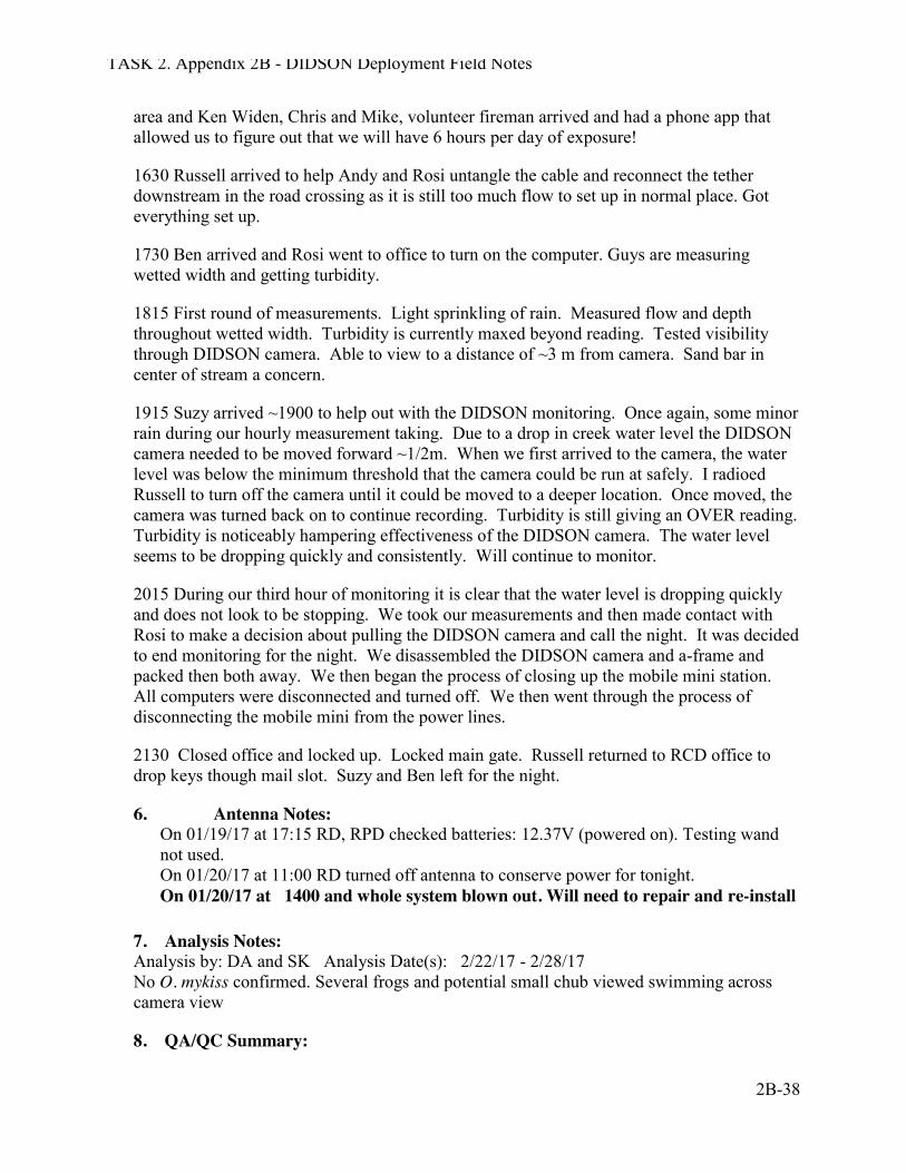
TASK 2. Appendix 2B - DIDSON Deployment Field Notes
2B-38
area and Ken Widen, Chris and Mike, volunteer fireman arrived and had a phone app that allowed us to figure out that we will have 6 hours per day of exposure!
1630 Russell arrived to help Andy and Rosi untangle the cable and reconnect the tether downstream in the road crossing as it is still too much flow to set up in normal place. Got everything set up.
1730 Ben arrived and Rosi went to office to turn on the computer. Guys are measuring wetted width and getting turbidity.
1815 First round of measurements. Light sprinkling of rain. Measured flow and depth throughout wetted width. Turbidity is currently maxed beyond reading. Tested visibility through DIDSON camera. Able to view to a distance of ~3 m from camera. Sand bar in center of stream a concern.
1915 Suzy arrived ~1900 to help out with the DIDSON monitoring. Once again, some minor rain during our hourly measurement taking. Due to a drop in creek water level the DIDSON camera needed to be moved forward ~1/2m. When we first arrived to the camera, the water level was below the minimum threshold that the camera could be run at safely. I radioed Russell to turn off the camera until it could be moved to a deeper location. Once moved, the camera was turned back on to continue recording. Turbidity is still giving an OVER reading. Turbidity is noticeably hampering effectiveness of the DIDSON camera. The water level seems to be dropping quickly and consistently. Will continue to monitor.
2015 During our third hour of monitoring it is clear that the water level is dropping quickly and does not look to be stopping. We took our measurements and then made contact with Rosi to make a decision about pulling the DIDSON camera and call the night. It was decided to end monitoring for the night. We disassembled the DIDSON camera and a-frame and packed then both away. We then began the process of closing up the mobile mini station. All computers were disconnected and turned off. We then went through the process of disconnecting the mobile mini from the power lines.
2130 Closed office and locked up. Locked main gate. Russell returned to RCD office to drop keys though mail slot. Suzy and Ben left for the night.
6. Antenna Notes: On 01/19/17 at 17:15 RD, RPD checked batteries: 12.37V (powered on). Testing wand not used. On 01/20/17 at 11:00 RD turned off antenna to conserve power for tonight. On 01/20/17 at 1400 and whole system blown out. Will need to repair and re-install
7. Analysis Notes: Analysis by: DA and SK Analysis Date(s): 2/22/17 - 2/28/17 No O. mykiss confirmed. Several frogs and potential small chub viewed swimming across camera view
8. QA/QC Summary:
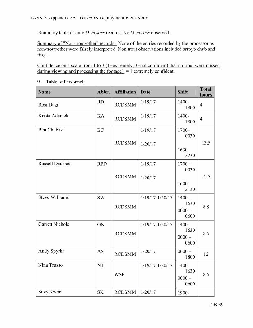
TASK 2. Appendix 2B - DIDSON Deployment Field Notes
2B-39
Summary table of only O. mykiss records: No O. mykiss observed.
Summary of "Non-trout/other" records: None of the entries recorded by the processor as non-trout/other were falsely interpreted. Non trout observations included arroyo chub and frogs.
Confidence on a scale from 1 to 3 (1=extremely, 3=not confident) that no trout were missed during viewing and processing the footage) = 1 extremely confident.
9. Table of Personnel:
Name Abbr. Affiliation Date Shift Total hours
Rosi Dagit RD RCDSMM 1/19/17 1400-1800 4
Krista Adamek KA RCDSMM 1/19/17 1400-1800 4
Ben Chubak BC
RCDSMM
1/19/17 1/20/17
1700–0030
1630-
2230
13.5
Russell Dauksis RPD
RCDSMM
1/19/17 1/20/17
1700–0030
1600-
2130
12.5
Steve Williams SW
RCDSMM
1/19/17-1/20/17 1400-1630
0000 – 0600
8.5
Garrett Nichols GN
RCDSMM
1/19/17-1/20/17 1400-1630
0000 – 0600
8.5
Andy Spyrka AS RCDSMM 1/20/17 0600 – 1800 12
Nina Trusso NT
WSP
1/19/17-1/20/17 1400-1630
0000 – 0600
8.5
Suzy Kwon SK RCDSMM 1/20/17 1900-
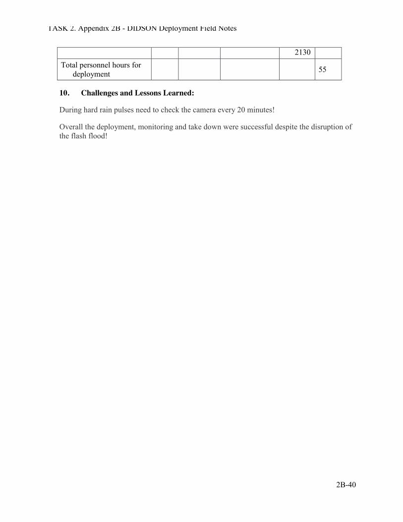
TASK 2. Appendix 2B - DIDSON Deployment Field Notes
2B-40
2130 Total personnel hours for
deployment 55
10. Challenges and Lessons Learned:
During hard rain pulses need to check the camera every 20 minutes!
Overall the deployment, monitoring and take down were successful despite the disruption of the flash flood!
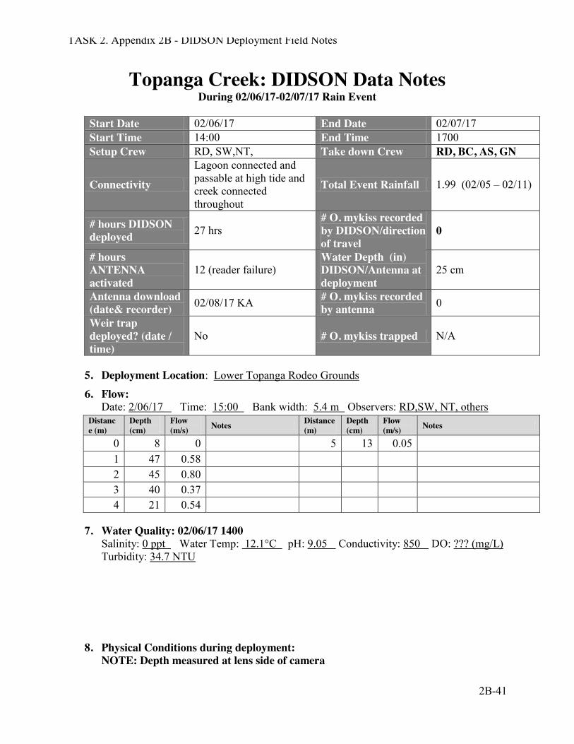
TASK 2. Appendix 2B - DIDSON Deployment Field Notes
2B-41
Topanga Creek: DIDSON Data Notes During 02/06/17-02/07/17 Rain Event
Start Date 02/06/17 End Date 02/07/17 Start Time 14:00 End Time 1700 Setup Crew RD, SW,NT, Take down Crew RD, BC, AS, GN
Connectivity
Lagoon connected and passable at high tide and creek connected throughout
Total Event Rainfall 1.99 (02/05 – 02/11)
# hours DIDSON deployed 27 hrs
# O. mykiss recorded by DIDSON/direction of travel
0
# hours ANTENNA activated
12 (reader failure) Water Depth (in) DIDSON/Antenna at deployment
25 cm
Antenna download (date& recorder) 02/08/17 KA # O. mykiss recorded
by antenna 0
Weir trap deployed? (date / time)
No # O. mykiss trapped N/A
5. Deployment Location: Lower Topanga Rodeo Grounds
6. Flow: Date: 2/06/17 Time: 15:00 Bank width: 5.4 m Observers: RD,SW, NT, others
Distance (m)
Depth (cm)
Flow (m/s) Notes Distance
(m) Depth (cm)
Flow (m/s) Notes
0 8 0 5 13 0.05 1 47 0.58 2 45 0.80 3 40 0.37 4 21 0.54
7. Water Quality: 02/06/17 1400 Salinity: 0 ppt Water Temp: 12.1°C pH: 9.05 Conductivity: 850 DO: ??? (mg/L) Turbidity: 34.7 NTU
8. Physical Conditions during deployment: NOTE: Depth measured at lens side of camera
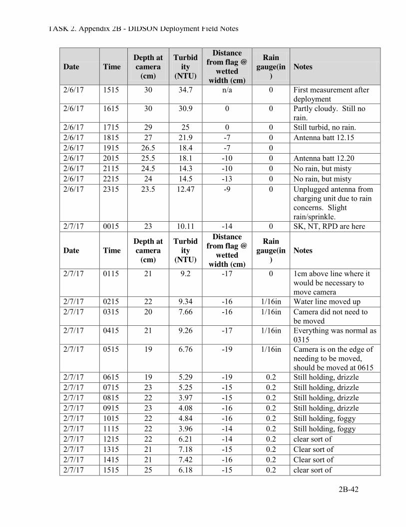
TASK 2. Appendix 2B - DIDSON Deployment Field Notes
2B-42
Date Time Depth at camera
(cm)
Turbidity
(NTU)
Distance from flag @
wetted width (cm)
Rain gauge(in
) Notes
2/6/17 1515 30 34.7 n/a 0 First measurement after deployment
2/6/17 1615 30 30.9 0 0 Partly cloudy. Still no rain.
2/6/17 1715 29 25 0 0 Still turbid, no rain. 2/6/17 1815 27 21.9 -7 0 Antenna batt 12.15 2/6/17 1915 26.5 18.4 -7 0 2/6/17 2015 25.5 18.1 -10 0 Antenna batt 12.20 2/6/17 2115 24.5 14.3 -10 0 No rain, but misty 2/6/17 2215 24 14.5 -13 0 No rain, but misty 2/6/17 2315 23.5 12.47 -9 0 Unplugged antenna from
charging unit due to rain concerns. Slight rain/sprinkle.
2/7/17 0015 23 10.11 -14 0 SK, NT, RPD are here
Date Time Depth at camera
(cm)
Turbidity
(NTU)
Distance from flag @
wetted width (cm)
Rain gauge(in
) Notes
2/7/17 0115 21 9.2 -17 0 1cm above line where it would be necessary to move camera
2/7/17 0215 22 9.34 -16 1/16in Water line moved up 2/7/17 0315 20 7.66 -16 1/16in Camera did not need to
be moved 2/7/17 0415 21 9.26 -17 1/16in Everything was normal as
0315 2/7/17 0515 19 6.76 -19 1/16in Camera is on the edge of
needing to be moved, should be moved at 0615
2/7/17 0615 19 5.29 -19 0.2 Still holding, drizzle 2/7/17 0715 23 5.25 -15 0.2 Still holding, drizzle 2/7/17 0815 22 3.97 -15 0.2 Still holding, drizzle 2/7/17 0915 23 4.08 -16 0.2 Still holding, drizzle 2/7/17 1015 22 4.84 -16 0.2 Still holding, foggy 2/7/17 1115 22 3.96 -14 0.2 Still holding, foggy 2/7/17 1215 22 6.21 -14 0.2 clear sort of 2/7/17 1315 21 7.18 -15 0.2 Clear sort of 2/7/17 1415 21 7.42 -16 0.2 Clear sort of 2/7/17 1515 25 6.18 -15 0.2 clear sort of
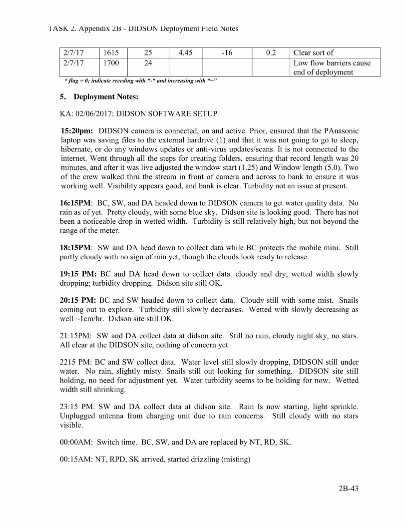
TASK 2. Appendix 2B - DIDSON Deployment Field Notes
2B-43
2/7/17 1615 25 4.45 -16 0.2 Clear sort of 2/7/17 1700 24 Low flow barriers cause
end of deployment * flag = 0; indicate receding with “-“ and increasing with “+”
5. Deployment Notes:
KA: 02/06/2017: DIDSON SOFTWARE SETUP
15:20pm: DIDSON camera is connected, on and active. Prior, ensured that the PAnasonic laptop was saving files to the external hardrive (1) and that it was not going to go to sleep, hibernate, or do any windows updates or anti-virus updates/scans. It is not connected to the internet. Went through all the steps for creating folders, ensuring that record length was 20 minutes, and after it was live adjusted the window start (1.25) and Window length (5.0). Two of the crew walked thru the stream in front of camera and across to bank to ensure it was working well. Visibility appears good, and bank is clear. Turbidity not an issue at present.
16:15PM: BC, SW, and DA headed down to DIDSON camera to get water quality data. No rain as of yet. Pretty cloudy, with some blue sky. Didson site is looking good. There has not been a noticeable drop in wetted width. Turbidity is still relatively high, but not beyond the range of the meter.
18:15PM: SW and DA head down to collect data while BC protects the mobile mini. Still partly cloudy with no sign of rain yet, though the clouds look ready to release.
19:15 PM: BC and DA head down to collect data. cloudy and dry; wetted width slowly dropping; turbidity dropping. Didson site still OK.
20:15 PM: BC and SW headed down to collect data. Cloudy still with some mist. Snails coming out to explore. Turbidity still slowly decreases. Wetted with slowly decreasing as well ~1cm/hr. Didson site still OK.
21:15PM: SW and DA collect data at didson site. Still no rain, cloudy night sky, no stars. All clear at the DIDSON site, nothing of concern yet.
2215 PM: BC and SW collect data. Water level still slowly dropping, DIDSON still under water. No rain, slightly misty. Snails still out looking for something. DIDSON site still holding, no need for adjustment yet. Water turbidity seems to be holding for now. Wetted width still shrinking.
23:15 PM: SW and DA collect data at didson site. Rain Is now starting, light sprinkle. Unplugged antenna from charging unit due to rain concerns. Still cloudy with no stars visible.
00:00AM: Switch time. BC, SW, and DA are replaced by NT, RD, SK.
00:15AM: NT, RPD, SK arrived, started drizzling (misting)
TASK 2. Appendix 2B - DIDSON Deployment Field Notes
2B-44
01:15AM The water line is 1cm above the water cooling hole, misting persisting
02:15AM The water line moved up , misting persisting
03:15AM The camera did not need to be moved, misting persisting.
04:15AM Same conditions seen in 03:15AM, camera did not need to be moved
05:15AM Camera is on edge of needing to be moved, the water line is right at the water cooling hole. Will probably need to be moved on the next check. The misting stopped, no precipitation.
0615 Rosi , Andy and Garrett take over. Camera still ok but flow level is dropping.
0715 Morning light! Flow holding over debris box so camera left in place. Started charging antenna batteries again but the reader is making funny light shows. Will call Krista for help. Andy and Garrett walked over to check lagoon connection. High tide at 0752 (6.2’). Lagoon connected and passable.
0815 Camera holding. No change.
0915- 1315 Camera holding. No change. May have seen a fish moveon video around 11 am!
1415 water level dropping to just below debris box window.
1515 moved camera approx 30 cm into creek to get to deeper flow. Flow is dropping and there are fish passage barriers both 10m up and downstream at the moment. Ben arrived to help and take over for Rosi.
Rosi went to check lagoon and it is connected but not passable for over 20 m. Ran up hill to check radar and storm system has been downgraded to showers so have called off the deployment. Called the team to let everyone know.
1630 Ben shut off top box before DIDSON program and jammed the camera lens. Had to power down the computer to break the logjam and waited 20 seconds before powering up computer and following directions to reconnect the camera. Once connected and recording, did correct procedure for shutting down and camera lens was ok.
1730 finished dep;oyment and went home
6. Antenna Notes: 2/6/2017: Connecting several extension cords from Mobile Mini to the 12V batteries in strong box to recharge them while it is not raining. 1815 – 12.15V 2015 –12.22V 2215—12.27V 0615- Antenna smells bad and turned off until light and we can see the problem more clearly.

TASK 2. Appendix 2B - DIDSON Deployment Field Notes
2B-45
0720 – Began recharging batteries again. Reader is making weird light show. 0830 spoke with krisa and went down to check connections again. Battery up to 12.24V off but drops when on.. weird light show continues. All connections look ok….turned off and continued charging. 1215 Krista came and trouble shooted….no clear reason but seems like hardware issue? Kept charging batteries and Krista took reader home to dry and speak with Warren,
7. Analysis Notes: Analysis by: RPD Analysis Date(s): 2/21/17 – 2/28/17
No observations of O. mykiss were detected from this deployment
8. QA/QC Summary: Summary table of only O. mykiss records: No O. mykiss observed
Summary of "Non-trout/other" records: None of the entries recorded by the processor as non-trout/other were falsely interpreted. Some chub were viewed but very small size distinguished them from trout.
Confidence on a scale from 1 to 3 (1=extremely, 3=not confident) that no trout were missed during viewing and processing the footage) = 1 extremely confident.
9. Table of Personnel:
Name Abbr. Affiliation Date Shift Total hours
Rosi Dagit RD
RCDSMM 2/6/2017 2/7/17
1400-1700 0600-1730
14.5
Krista Adamek KA RCDSMM
2/6/2017 2/7/17
1430-1530 1130-1300
2.5
Ben Chubak BC RCDSMM
2/6/2017 2/7/2017
1600-0015 1445-1730
11
Russell Dauksis RPD RCDSMM 2/7/17 0000-0600 6 Steve Williams SW RCDSMM 2/6/2017 1400-0015 8.25 Garrett Nichols GN RCDSMM 2/7/17 0600-1730 11.5 Andy Spyrka AS RCDSMM 2/7/17 0600-1730 11.5 Nina Trusso NT
WSP 2/6/2017 2/7/17
1400-1700 0000-0600
9
Suzy Kwon SK RCDSMM
2/6/2017 2/7/17
1400-1600 0000-0600
8
Danielle Alvarez DA RCDSMM 2/6/2017 1400-0015 8.25
TASK 2. Appendix 2B - DIDSON Deployment Field Notes
2B-46
Griffin Srednick GS RCDSMM 2/6/2017 1400-1600 2 Total personnel hours for
deployment 92.5
10. Challenges and Lessons Learned:
Really important to follow shut down directions! We were able to get things back up by doing a hard crash, but not ideal. Sam will send some directions on other way to do this when camera is frozen.
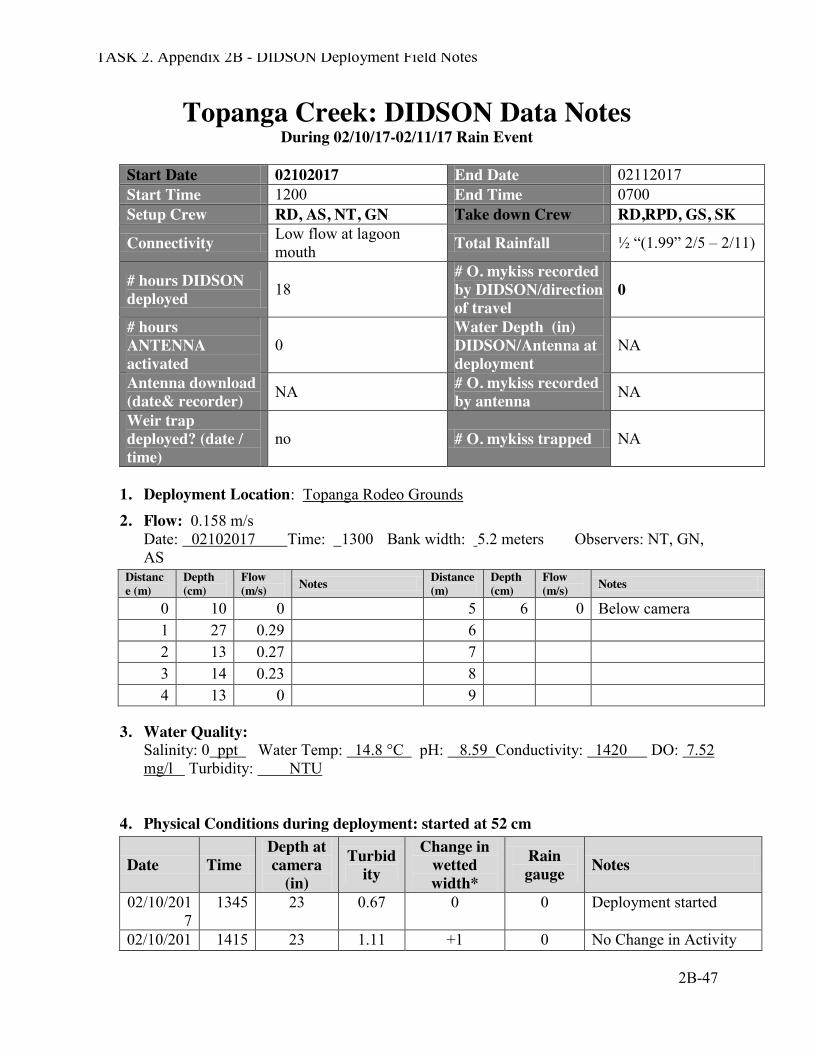
TASK 2. Appendix 2B - DIDSON Deployment Field Notes
2B-47
Topanga Creek: DIDSON Data Notes During 02/10/17-02/11/17 Rain Event
Start Date 02102017 End Date 02112017 Start Time 1200 End Time 0700 Setup Crew RD, AS, NT, GN Take down Crew RD,RPD, GS, SK
Connectivity Low flow at lagoon mouth Total Rainfall ½ “(1.99” 2/5 – 2/11)
# hours DIDSON deployed 18
# O. mykiss recorded by DIDSON/direction of travel
0
# hours ANTENNA activated
0 Water Depth (in) DIDSON/Antenna at deployment
NA
Antenna download (date& recorder) NA # O. mykiss recorded
by antenna NA
Weir trap deployed? (date / time)
no # O. mykiss trapped NA
1. Deployment Location: Topanga Rodeo Grounds
2. Flow: 0.158 m/s Date: 02102017 Time: 1300 Bank width: 5.2 meters Observers: NT, GN, AS
Distance (m)
Depth (cm)
Flow (m/s) Notes Distance
(m) Depth (cm)
Flow (m/s) Notes
0 10 0 5 6 0 Below camera 1 27 0.29 6 2 13 0.27 7 3 14 0.23 8 4 13 0 9
3. Water Quality: Salinity: 0 ppt Water Temp: 14.8 °C pH: 8.59 Conductivity: 1420 DO: 7.52 mg/l Turbidity: NTU
4. Physical Conditions during deployment: started at 52 cm
Date Time Depth at camera
(in)
Turbidity
Change in wetted width*
Rain gauge Notes
02/10/2017
1345 23 0.67 0 0 Deployment started
02/10/201 1415 23 1.11 +1 0 No Change in Activity
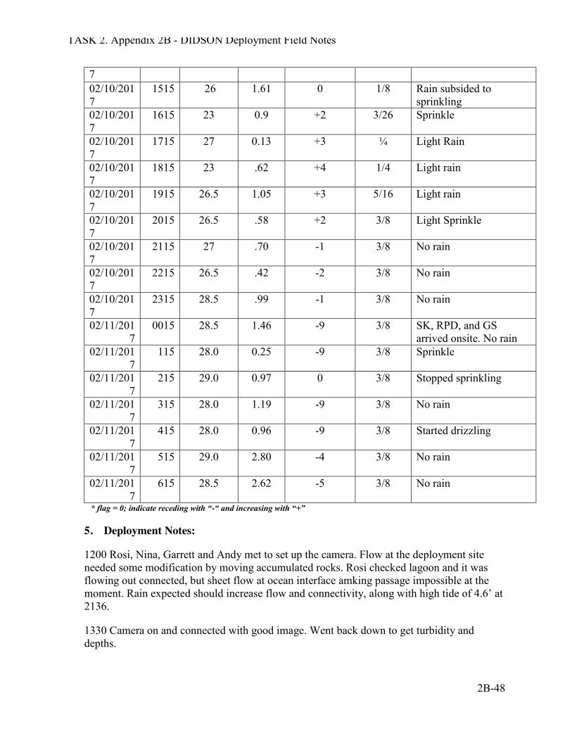
TASK 2. Appendix 2B - DIDSON Deployment Field Notes
2B-48
7 02/10/2017
1515 26 1.61 0 1/8 Rain subsided to sprinkling
02/10/2017
1615 23 0.9 +2 3/26 Sprinkle
02/10/2017
1715 27 0.13 +3 ¼ Light Rain
02/10/2017
1815 23 .62 +4 1/4 Light rain
02/10/2017
1915 26.5 1.05 +3 5/16 Light rain
02/10/2017
2015 26.5 .58 +2 3/8 Light Sprinkle
02/10/2017
2115 27 .70 -1 3/8 No rain
02/10/2017
2215 26.5 .42 -2 3/8 No rain
02/10/2017
2315 28.5 .99 -1 3/8 No rain
02/11/2017
0015 28.5 1.46 -9 3/8 SK, RPD, and GS arrived onsite. No rain
02/11/2017
115 28.0 0.25 -9 3/8 Sprinkle
02/11/2017
215 29.0 0.97 0 3/8 Stopped sprinkling
02/11/2017
315 28.0 1.19 -9 3/8 No rain
02/11/2017
415 28.0 0.96 -9 3/8 Started drizzling
02/11/2017
515 29.0 2.80 -4 3/8 No rain
02/11/2017
615 28.5 2.62 -5 3/8 No rain
* flag = 0; indicate receding with “-“ and increasing with “+”
5. Deployment Notes:
1200 Rosi, Nina, Garrett and Andy met to set up the camera. Flow at the deployment site needed some modification by moving accumulated rocks. Rosi checked lagoon and it was flowing out connected, but sheet flow at ocean interface amking passage impossible at the moment. Rain expected should increase flow and connectivity, along with high tide of 4.6’ at 2136.
1330 Camera on and connected with good image. Went back down to get turbidity and depths.
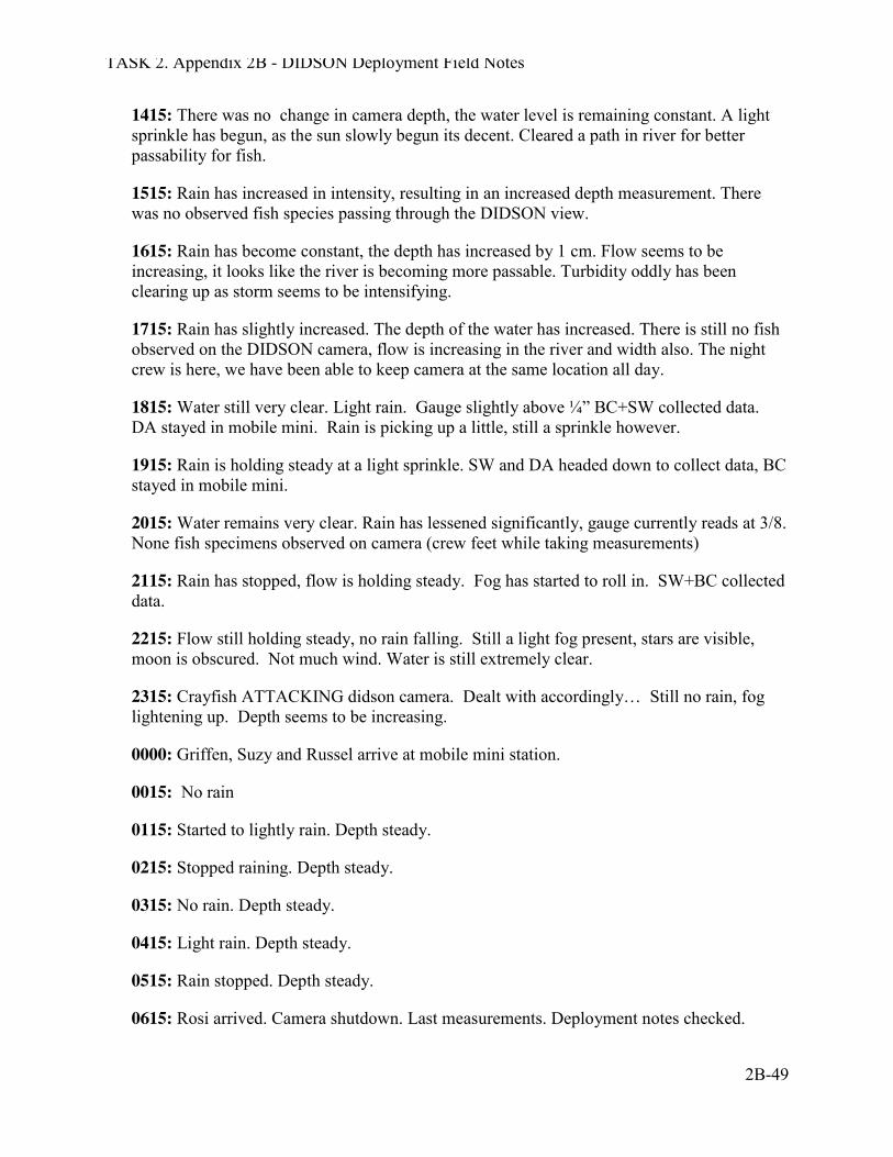
TASK 2. Appendix 2B - DIDSON Deployment Field Notes
2B-49
1415: There was no change in camera depth, the water level is remaining constant. A light sprinkle has begun, as the sun slowly begun its decent. Cleared a path in river for better passability for fish.
1515: Rain has increased in intensity, resulting in an increased depth measurement. There was no observed fish species passing through the DIDSON view.
1615: Rain has become constant, the depth has increased by 1 cm. Flow seems to be increasing, it looks like the river is becoming more passable. Turbidity oddly has been clearing up as storm seems to be intensifying.
1715: Rain has slightly increased. The depth of the water has increased. There is still no fish observed on the DIDSON camera, flow is increasing in the river and width also. The night crew is here, we have been able to keep camera at the same location all day.
1815: Water still very clear. Light rain. Gauge slightly above ¼” BC+SW collected data. DA stayed in mobile mini. Rain is picking up a little, still a sprinkle however.
1915: Rain is holding steady at a light sprinkle. SW and DA headed down to collect data, BC stayed in mobile mini.
2015: Water remains very clear. Rain has lessened significantly, gauge currently reads at 3/8. None fish specimens observed on camera (crew feet while taking measurements)
2115: Rain has stopped, flow is holding steady. Fog has started to roll in. SW+BC collected data.
2215: Flow still holding steady, no rain falling. Still a light fog present, stars are visible, moon is obscured. Not much wind. Water is still extremely clear.
2315: Crayfish ATTACKING didson camera. Dealt with accordingly… Still no rain, fog lightening up. Depth seems to be increasing.
0000: Griffen, Suzy and Russel arrive at mobile mini station.
0015: No rain
0115: Started to lightly rain. Depth steady.
0215: Stopped raining. Depth steady.
0315: No rain. Depth steady.
0415: Light rain. Depth steady.
0515: Rain stopped. Depth steady.
0615: Rosi arrived. Camera shutdown. Last measurements. Deployment notes checked.
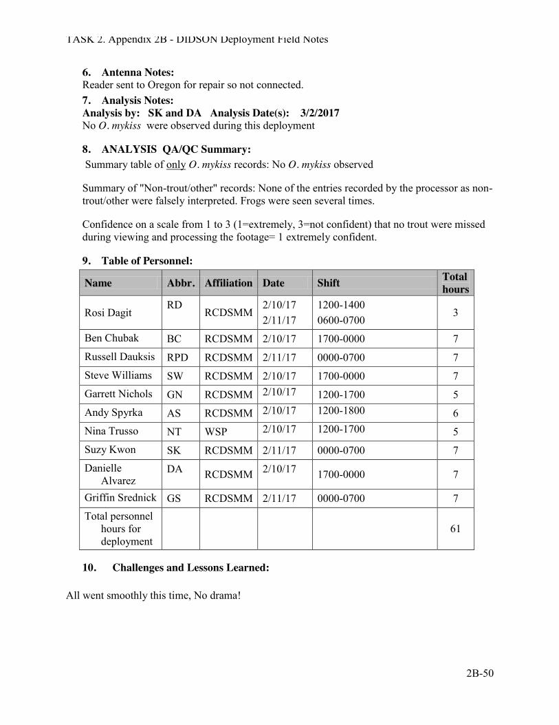
TASK 2. Appendix 2B - DIDSON Deployment Field Notes
2B-50
6. Antenna Notes: Reader sent to Oregon for repair so not connected. 7. Analysis Notes: Analysis by: SK and DA Analysis Date(s): 3/2/2017 No O. mykiss were observed during this deployment
8. ANALYSIS QA/QC Summary: Summary table of only O. mykiss records: No O. mykiss observed
Summary of "Non-trout/other" records: None of the entries recorded by the processor as non-trout/other were falsely interpreted. Frogs were seen several times.
Confidence on a scale from 1 to 3 (1=extremely, 3=not confident) that no trout were missed during viewing and processing the footage= 1 extremely confident.
9. Table of Personnel:
Name Abbr. Affiliation Date Shift Total hours
Rosi Dagit RD
RCDSMM 2/10/17 2/11/17
1200-1400 0600-0700
3
Ben Chubak BC RCDSMM 2/10/17 1700-0000 7 Russell Dauksis RPD RCDSMM 2/11/17 0000-0700 7 Steve Williams SW RCDSMM 2/10/17 1700-0000 7 Garrett Nichols GN RCDSMM 2/10/17 1200-1700 5 Andy Spyrka AS RCDSMM 2/10/17 1200-1800 6 Nina Trusso NT WSP 2/10/17 1200-1700 5 Suzy Kwon SK RCDSMM 2/11/17 0000-0700 7 Danielle
Alvarez DA RCDSMM 2/10/17 1700-0000 7
Griffin Srednick GS RCDSMM 2/11/17 0000-0700 7 Total personnel
hours for deployment
61
10. Challenges and Lessons Learned: All went smoothly this time, No drama!
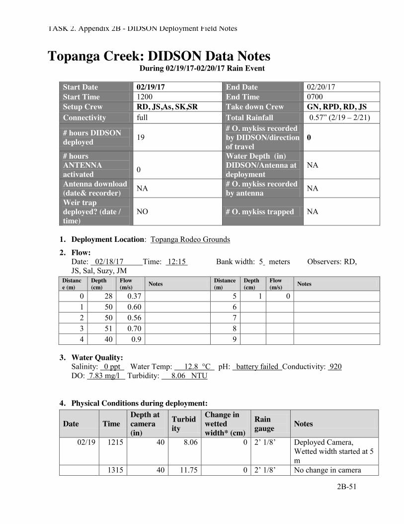
TASK 2. Appendix 2B - DIDSON Deployment Field Notes
2B-51
Topanga Creek: DIDSON Data Notes During 02/19/17-02/20/17 Rain Event
Start Date 02/19/17 End Date 02/20/17 Start Time 1200 End Time 0700 Setup Crew RD, JS,As, SK,SR Take down Crew GN, RPD, RD, JS Connectivity full Total Rainfall 0.57” (2/19 – 2/21)
# hours DIDSON deployed 19
# O. mykiss recorded by DIDSON/direction of travel
0
# hours ANTENNA activated
0
Water Depth (in) DIDSON/Antenna at deployment
NA
Antenna download (date& recorder) NA # O. mykiss recorded
by antenna NA
Weir trap deployed? (date / time)
NO # O. mykiss trapped NA
1. Deployment Location: Topanga Rodeo Grounds
2. Flow: Date: 02/18/17 Time: 12:15 Bank width: 5 meters Observers: RD, JS, Sal, Suzy, JM
Distance (m)
Depth (cm)
Flow (m/s) Notes Distance
(m) Depth (cm)
Flow (m/s) Notes
0 28 0.37 5 1 0 1 50 0.60 6 2 50 0.56 7 3 51 0.70 8 4 40 0.9 9
3. Water Quality: Salinity: 0 ppt Water Temp: 12.8 °C pH: battery failed Conductivity: 920 DO: 7.83 mg/l Turbidity: 8.06 NTU
4. Physical Conditions during deployment:
Date Time Depth at camera (in)
Turbidity
Change in wetted width* (cm)
Rain gauge Notes
02/19 1215 40 8.06 0 2’ 1/8’ Deployed Camera, Wetted width started at 5 m
1315 40 11.75 0 2’ 1/8’ No change in camera
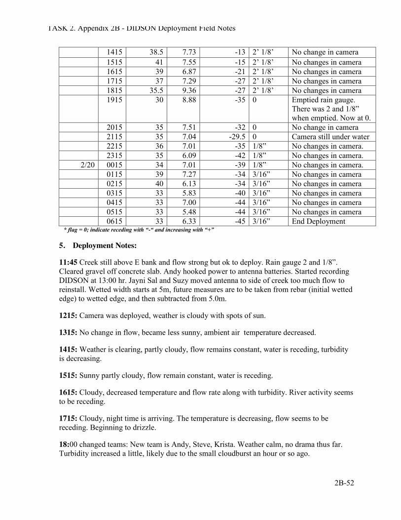
TASK 2. Appendix 2B - DIDSON Deployment Field Notes
2B-52
1415 38.5 7.73 -13 2’ 1/8’ No change in camera 1515 41 7.55 -15 2’ 1/8’ No changes in camera 1615 39 6.87 -21 2’ 1/8’ No changes in camera 1715 37 7.29 -27 2’ 1/8’ No changes in camera 1815 35.5 9.36 -27 2’ 1/8’ No changes in camera 1915 30 8.88 -35 0 Emptied rain gauge.
There was 2 and 1/8” when emptied. Now at 0.
2015 35 7.51 -32 0 No change in camera 2115 35 7.04 -29.5 0 Camera still under water 2215 36 7.01 -35 1/8” No changes in camera. 2315 35 6.09 -42 1/8” No changes in camera.
2/20 0015 34 7.01 -39 1/8” No changes in camera. 0115 39 7.27 -34 3/16” No changes in camera 0215 40 6.13 -34 3/16” No changes in camera 0315 33 5.83 -40 3/16” No changes in camera 0415 33 7.00 -44 3/16” No changes in camera 0515 33 5.48 -44 3/16” No changes in camera 0615 33 6.33 -45 3/16” End Deployment
* flag = 0; indicate receding with “-“ and increasing with “+”
5. Deployment Notes:
11:45 Creek still above E bank and flow strong but ok to deploy. Rain gauge 2 and 1/8”. Cleared gravel off concrete slab. Andy hooked power to antenna batteries. Started recording DIDSON at 13:00 hr. Jayni Sal and Suzy moved antenna to side of creek too much flow to reinstall. Wetted width starts at 5m, future measures are to be taken from rebar (initial wetted edge) to wetted edge, and then subtracted from 5.0m.
1215: Camera was deployed, weather is cloudy with spots of sun.
1315: No change in flow, became less sunny, ambient air temperature decreased.
1415: Weather is clearing, partly cloudy, flow remains constant, water is receding, turbidity is decreasing.
1515: Sunny partly cloudy, flow remain constant, water is receding.
1615: Cloudy, decreased temperature and flow rate along with turbidity. River activity seems to be receding.
1715: Cloudy, night time is arriving. The temperature is decreasing, flow seems to be receding. Beginning to drizzle.
18:00 changed teams: New team is Andy, Steve, Krista. Weather calm, no drama thus far. Turbidity increased a little, likely due to the small cloudburst an hour or so ago.
TASK 2. Appendix 2B - DIDSON Deployment Field Notes
2B-53
1815: Cloudy, and quite dark. No drizzle. Rained lightly about an hour ago up in Topanga.
19:25: Emptied the rain gauge, no change since the morning (when it read 2 and 1/8”). Turbidy down a little bit. Water level still decreasing slightly, but camera still covered with water.
20:15: Creek level has slightly risen.
21:15: Stopped drizzling. Camera still under water.
21:30: Light rain starting.
22:15: Rain gauge 1/8” in 30 minutes. Light rain continues, creek level steady, seems like it is flowing faster.
23:15: Still raining. Water levels are staying the same, but wetted edge is getting further from the rebar.
00:00 Change in crew to Jayni, Garrett and Russell.
00:15: Drizzling.
01:15: The drizzle has lessened to very light drizzling. Water level about level to the top of the DIDSON box
02:15: Drizzle still same. Water level the same. Wetting area is starting to vary because edge is hard to discern and the bank is nearly horizontal with the water level.
03:15: Drizzle still same. Water level slightly lowered but still level with top of DIDSON box. Wetting area now clearly decreased. Surrounding temperature turned very cold. (~50 degree Fahrenheit)
04:15: Drizzle still same. Wetting area decreased.
05:15: No noticeable change.
06:36: End Deployment drizzle not much excitement.
6. Antenna Notes: Antenna blown out still! 7. Analysis Notes: Analysis by: AS Analysis Date(s): 2/27 – 2/28 No O. mykiss observed during this deployment
8. ANALYSIS QA/QC Summary: Summary table of only O. mykiss records: No O. mykiss observed
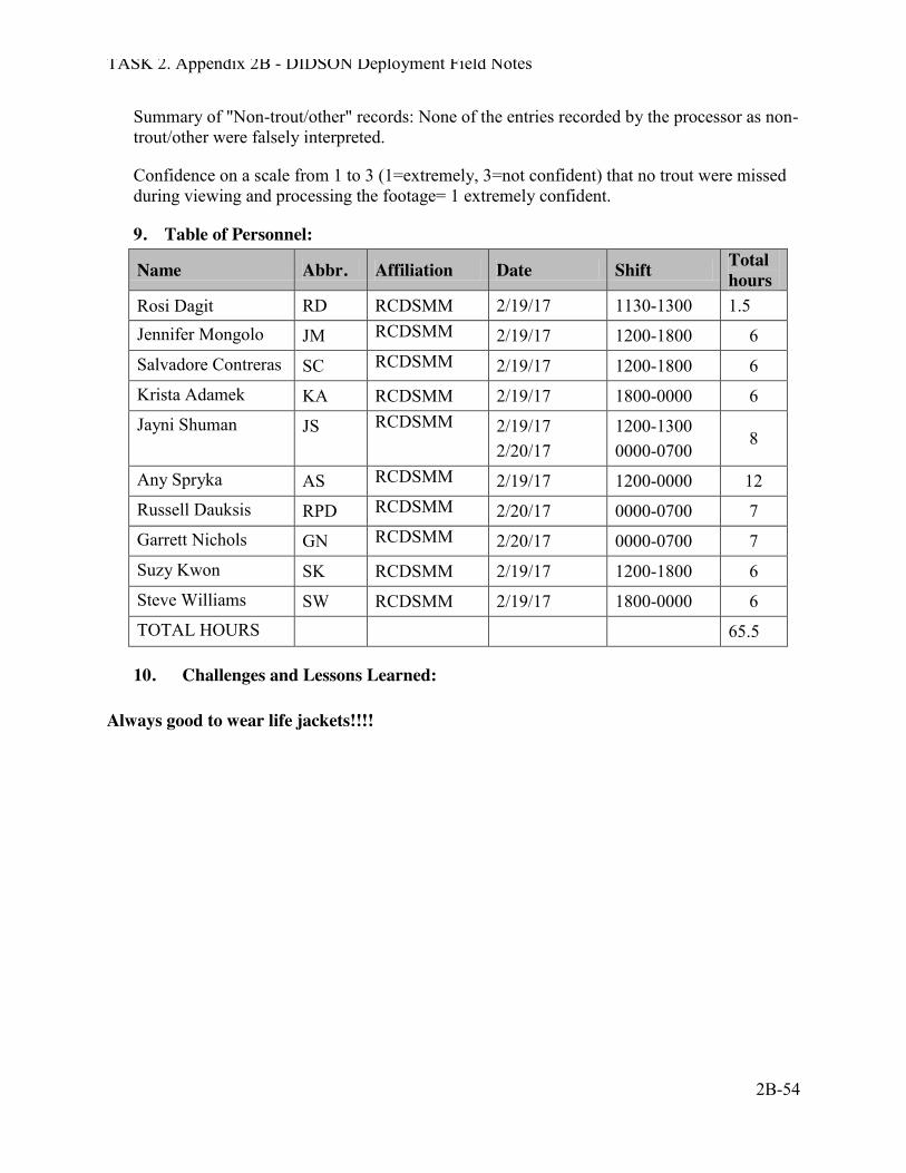
TASK 2. Appendix 2B - DIDSON Deployment Field Notes
2B-54
Summary of "Non-trout/other" records: None of the entries recorded by the processor as non-trout/other were falsely interpreted.
Confidence on a scale from 1 to 3 (1=extremely, 3=not confident) that no trout were missed during viewing and processing the footage= 1 extremely confident.
9. Table of Personnel:
Name Abbr. Affiliation Date Shift Total hours
Rosi Dagit RD RCDSMM 2/19/17 1130-1300 1.5 Jennifer Mongolo JM RCDSMM 2/19/17 1200-1800 6 Salvadore Contreras SC RCDSMM 2/19/17 1200-1800 6 Krista Adamek KA RCDSMM 2/19/17 1800-0000 6 Jayni Shuman JS RCDSMM 2/19/17
2/20/17 1200-1300 0000-0700
8
Any Spryka AS RCDSMM 2/19/17 1200-0000 12 Russell Dauksis RPD RCDSMM 2/20/17 0000-0700 7 Garrett Nichols GN RCDSMM 2/20/17 0000-0700 7 Suzy Kwon SK RCDSMM 2/19/17 1200-1800 6 Steve Williams SW RCDSMM 2/19/17 1800-0000 6 TOTAL HOURS 65.5
10. Challenges and Lessons Learned:
Always good to wear life jackets!!!!