Embed Size (px)
Citation preview
COLUMBIA RIVER CROSSING TASK FORCE | September 27, 2006
PAGE 1 OF 11
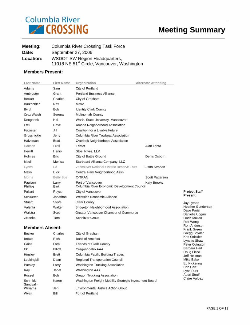
Meeting: Columbia River Crossing Task Force
Date: September 27, 2006
Location: WSDOT SW Region Headquarters, 11018 NE 51st Circle, Vancouver, Washington
Members Present: Last Name First Name Organization Alternate Attending Adams Sam City of Portland Ambruster Grant Portland Business Alliance Becker Charles City of Gresham Burkholder Rex Metro Byrd Bob Identity Clark County Cruz Walsh Serena Multnomah County Dengerink Hal Wash. State University- Vancouver Frei Dave Amada Neighborhood Association Fuglister Jill Coalition for a Livable Future Grossnickle Jerry Columbia River Towboat Association Halverson Brad Overlook Neighborhood Association Hansen Fred TriMet Alan Lehto Hewitt Henry Stoel Rives, LLP Holmes Eric City of Battle Ground Denis Osborn Isbell Monica Starboard Alliance Company, LLC Lynch Ed Vancouver National Historic Reserve Trust Elson Strahan Malin Dick Central Park Neighborhood Assn. Morris Betty Sue C-TRAN Scott Patterson Paulson Larry Port of Vancouver Katy Brooks Phillips Bart Columbia River Economic Development Council Pollard Royce City of Vancouver Schlueter Jonathan Westside Economic Alliance Stuart Steve Clark County Valenta Walter Bridgeton Neighborhood Association Walstra Scot Greater Vancouver Chamber of Commerce Zelenka Tom Schnitzer Group Members Absent: Becker Charles City of Gresham Brown Rich Bank of America Caine Lora Friends of Clark County Eki Elliott Oregon/Idaho AAA Hinsley Brett Columbia Pacific Building Trades Lookingbill Dean Regional Transportation Council Pursley Larry Washington Trucking Association Ray Janet Washington AAA Russel Bob Oregon Trucking Association Schmidt Karen Washington Freight Mobility Strategic Investment Board Sundvall-Williams Jeri Environmental Justice Action Group Wyatt Bill Port of Portland
Meeting Summary
Project Staff Present: Jay Lyman Heather Gundersen Dave Parisi Danielle Cogan Linda Mullen Rex Wong Ron Anderson Frank Green Gregg Snyder Kris Strickler Lynette Shaw Peter Ovington Barbara Hart Doug Ficco Jeff Heilman Mike Baker Ed Pickering Bob Hart Lynn Rust Audri Streif Claire Valdez

COLUMBIA RIVER CROSSING TASK FORCE | September 27, 2006
PAGE 2 OF 11
1. Welcome & Announcements
• Eric Holmes: Resigned as city manager for City of Battle Ground.
--My last day with the City of Battle Ground will be Oct. 13. Denis Osborn, who is here, will fill in for me. He has filled in on the Task Force for me and is familiar with the CRC project and the process. He will transition seamlessly. Denis will take my place at the table later tonight, and I have enjoyed being involved in the project and look forward seeing something be built
2. Acknowledge letter to Co-Chairs from Task Force business representatives
Scot Walstra briefly explained purpose of the letter to Co-Chairs : --This is a culmination of some work that the representatives for business, freight, transportation and general economics in the region have put together. It is a summary to acknowledge the bridge has economic implications and opportunities well beyond the bridge influence area and is critically important to the economy of our region. We wanted to make sure that those of us who represent business, freight mobility, transportation, and the general economy are going to push for a bridge that really does add capacity, improves access, and that acknowledges the economic importance of this bridge to the region. We appreciate the opportunity to enter this into the record. This is a once in a lifetime opportunity, and the importance of this bridge to the western region is critical. That is really what this is about. --At what point might this group expect a response to this letter?
(The co-chairs have asked project staff to draft a letter and we will have that ready in a couple of weeks to send around to the Task Force.)
--Part of the discussion we want to have is whether the current criteria will satisfy the needs that were raised here or if there are special ones we need to pull out and address 3. City of Portland moratorium on development on Hayden Island --Hal: We did not have enough notice to put this in the agenda, We did not receive this early enough to notify the public of this item. Our ordinary rules indicate that this information is supposed to be made public ahead of time, we will have to address that before we can take action, perhaps make a motion to suspend the rules for this case. Commissioner Adams introduced his proposal for Task Force consideration: --The information being passed around summarizes the findings from David Evans and Associates and the internal review of aspects of the earlier version. We did pass a resolution noting this and we noted that we would be considering taking an actual position on the findings. DEA found that I-5 in the vicinity
NOTE: Task Force questions and comments are in italics (Staff responses are in parentheses)

COLUMBIA RIVER CROSSING TASK FORCE | September 27, 2006
PAGE 3 OF 11
of Hayden Island operates at full capacity for at least 7 hours a day, there is only one way on and off the island via I-5. During congested periods emergency vehicles experience delays and ramps exceed capacity. There is an increase in crashes, 75 percent are rear-end crashes, which indicates that the freeway is at capacity. Transit does not serve the island well. There is only a bus line that gets stuck in traffic. All residential capacity has been built, but there is still significant retail square footage that can be built in commercial zones. If there is evidence that there is a lack of transportation capacity and a lack of plans to deal with the transportation capacity, then a development moratorium may be imposed.
• Action: Approved - Suspension of the rules pertaining to taking action on a subject that was not presented to the public prior to the meeting.
--Bi-state coordinating committee and JPACT discussed this moratorium and decided to support it --Does anyone have information about commercial development along the I-205 area? Adams: Yes, that area was designed to support much more mixed use, and not necessarily IKEA. We have studied the effect of 8,000 to 13,000 additional trips to the area. They have fewer customers that stay longer, and they do not have the same impact as other big box stores. Outside experts show that the area can handle the traffic. -- On Hayden Island, most of the new alignments being developed there are exactly through and over the big box areas. On the I-205 side those alignments are already defined.
• Action: Approved resolution presented by Commissioner Adams
4. Public Comment • Jim Howell: Representing Association of Oregon Rail and Transit Advocates (AORTA).
Submitted remarks in writing. The alleged need to retrofit the bridge has not been established. If the big one hits, the bridge over the Columbia River will not be our concern. The railroad bridge will be. The highway traffic has an alternate route to use in the chance of an earthquake, the rail system does not. The string of barges snaking through the river would be more likely to damage to the bridge than an earthquake. The top priority of the Columbia River Crossing should be a replacement of the swing span with a lift span on the BNSF railroad bridge. It would allow more barge totes to avoid bridge lifts. Traffic would be minimal because fewer bridge lifts would be required to allow barge traffic. If this can be kept to a minimum, then no other changes to the current bridge system is needed. If a lower speed limit is implemented to accommodate less sight distance, that would solve congestion problems. This brings into question the earlier decision of eliminating any bridge that has a lift span. We should consider the trade off of a low profile bridge with occasional lifts versus a high profile bridge expanding over the railroad field in downtown Vancouver. Building a low profile supplemental bridge with a lift span with retrofits to the railroad bridge would be far less expensive, not become an eye sore, would hold up during a major earthquake, and would enhance navigational ability.
• Sharen Nasset: I went to the Coast Guard hearing. I spoke with the bridge inspector and he indicated that he was really surprised that we are so obsessed with seismic of the bridge. It is not required by the federal government, would only be triggered if something was actually done to the bridge, including taking the on and off ramps off at Jantzen beach. He had never heard of an obsession and that the seismic mostly had to do with a bridge that is in A-1 status, meets all federal requirements. He had never seen pilings that were made so large. The drawings for

COLUMBIA RIVER CROSSING TASK FORCE | September 27, 2006
PAGE 4 OF 11
the new seismic upgrades were not to scale or were not done by experts because they were so enormous in scale to things he had seen before. The concern is that those would make the channels small. The pilings underneath are wooden. That is standard throughout the world and is commonly used in the Netherlands today. They do not decay because they do not hit air. These pilings that were driven into the ground are from old growth and are huge and are not 2 or 3 inches. These pilings are what is common, any bridge built before 1950, and most bridges now throughout the US use these pilings. The seismic issues, and the pile-on issues are both red herrings. And as many people have suggested…when are seismic upgrades called for? What triggers it needs to be answered. There is nothing wrong with those bridges. You will regret taking them down. I am glad DEA has finally recognized that Hayden Island has 7 hours of congestion.
5. Meeting Summary Approval • Action: Approved - Draft summary of August 16, 2006 meeting summary
6. Design Concepts – Part Two Transit presentation - Gregg Snyder Highway presentation - Ron Anderson Break to view maps on display in the back of the room
(There are not two different efforts at work with highway and transit. The engineers for both pieces work together everyday and on the maps in the back we have integrated the transit alignments into the highway alignment maps. I would like to reiterate that these are models that are being tested. We do not have the data to show how well they work. The input is needed to help decide whether or not these designs will answer the questions that need to be answered.)
Discussion --We are going to begin collecting data about how these alternatives work. It is critical that we get your questions and input.
--On our transit models, we talked about measuring the impacts of these transit alternatives. We are looking at ending the transit alignment at SR-500, when we ought to be looking at the location north where one of the largest park n’ rides we have is at 134th.
(During the next phase of work we will be looking at different transit alignments than what you have seen in the back in the room. Right now we are using the representative alignments to gather information about the modes.)
--You have already decided to go beyond to Clark College to Kiggins. Also, how many of those riders are coming out of 134t ? Instead of using a hypothetical park n’ ride location, why not consider using one that already exists? It seems like it would give you a lot better data.
(We are making sure that those that use Salmon Creek park and ride would have a transfer to Kiggins, and as we move into the next phase we will be able to more appropriately determine where the right terminus should go. That decision will be made based on potential ridership and cost. Ultimately the right terminus is a function of ridership and the cost to fund it. We will be looking at those two factors in determining the right point to end the alignment.)

COLUMBIA RIVER CROSSING TASK FORCE | September 27, 2006
PAGE 5 OF 11
--How can you judge that if you are not going to asses it? How will you know how the more northern spots will perform?
(For the light rail alternative that stops at Kiggins, the modeling assumptions include transit service that will provide access to Clark College station and Kiggins Bowl from other areas. While it is not a perfect test, it will give us a sense of the potential level of transit ridership in those areas.)
--If that information is important, why not test it?
(At this point it is a matter of timing. We have a schedule to test a set of alternatives. We can certainly capture that idea as we move forward.)
--My understanding of where we are is setting up ways to choose the transit mode. Once that decision is made, then we can work through the alignments, stations, and bus stop decision in the next phases.
--Data is skewed against Bus Rapid Transit because it starts higher and does not transfer. It skews it not to study it more like Hal said. The comparison is unfair. In the I-5 strategy an alignment is not going to go to 134th, but down SR-500 to do the light rail loop. That is not portrayed in any of these models.
(We are not ignoring the recommendations. It is a question of timing at which we answer those questions.)
(We have a group made up of our six sponsoring agencies, and we reached the conclusion that these are fair ways to compare the transit modes. The data is not skewed. They comply with federal agency standards of ways to compare the modes.)
--How do you create the alignments? The alignments will affect how they perform. It can change cost, rider-ship, land acquisition, efficiency, right of way acquisition. It seems backwards to choose the mode, then the alignment. Why are we doing it this way? We need to choose the alignments based on our criteria first.
(We have done a lot of work to decide which alignments to test the modes on. We did look at many options. We settled on alignments that would work well for all the transit modes we are looking at.)
--What criteria did you use to decide those?
(Availability of right of way, cost, park and ride use, potential speed issues, transit market service. In Vancouver we have the benefit of the city’s downtown plan that identifies a preferred alignment for high capacity transit. )
-- Are we using numbers outside the Bridge Influence Area (BIA) for commute times?
(We are looking at total time for trips through the BIA.) --In each direction there would be three auxiliary and three through, which adds up to 12 lanes. Is that true?
(For design layout purposes we have looked at maximum amount of lanes, but we have not made any decisions on their performance or lane balance. That decision will be made in the DEIS process.)
--The agreement we came to was to look at 10 lanes, and now it has morphed. If that has changed we need to notify the public

COLUMBIA RIVER CROSSING TASK FORCE | September 27, 2006
PAGE 6 OF 11
--Alternative 4 is dead upon arrival, because Federal Transit Administration (FTA) is not going to approve light rail on a bridge that is not safe.
(We were trying to show some representative alignments for upstream, downstream, and supplemental. There is not one treated more favorably than another.)
--Are we evaluating the option of leaving a single bridge for ped/bike?
(Later tonight we are having a discussion on the use for existing bridges, including potential uses, and yes, the use for bike/ped is one of those uses.)
--What is the sequence for the rest of the year?
(This is the second of two meetings where we have been introducing the design concepts that were developed over the summer. The next two meeting in October and November will be starting to report the results of analysis that was developed. The last part of setting the stage for the upcoming discussion of analysis results will be the presentation this evening of the performance measures that were developed for each of the evaluation criteria adopted earlier this year. The next two meetings will be for presenting data for making decisions about a river crossing and transit mode to be carried into the DEIS. In November we will be presenting all the information we have available for making transit mode choices that will be studied in the DEIS. We will also be presenting the draft staff recommendation for those two key decisions and we will have a chance to have conversations about that. In January we will go public with that information and in February you will hear the public comments and have a chance to weigh in on whether we are going in the right direction.)
--When is freight modeling happening? When are we going to hear about how trucks will move in and about those designs?
(The freight working group is meeting regularly and is currently working on a memo that responds to the freight components that were developed. Hopefully we will have that soon. The metro modeling part that we are doing now includes trucks, and we will have that information this fall.)
--I was glad to hear discussion about the design alternatives and the variety of criteria being used. What is unclear is how you weighed those or measured them. Whether it is transit or roadway, we need to understand the weighing and criteria and why you have bundled thing up the way you have. There are a variety of good reasons why you did this, but it is not transparent.
(There are two parts to that. The first part is that this group adopted a set of criteria for the whole project. Those criteria are driving decisions down to the detail level, but when you get down to a decision about interchange ramps, for example, there are other things to consider as well. There are many ideas that we may have initially considered, but they may not have made it beyond the first doodle because they were not physically buildable. There are two levels of analysis. Most of what you are seeing today is the result of a lot of background work about what is feasible. While at the same time designers are thinking about the things that this group has said are important to them.)
(As we narrow the alternatives to go into DEIS, we are not going to ask this group to pick an interchange design, but we are looking for a decision on a river crossing and transit. Those two decisions will allow the EIS to evaluate options for the other pieces. The interchanges and such can be developed after the two main decisions have been made.)
--At what point do we discuss the performance measures? We didn’t adopt these measures as I recall. Is that correct?

COLUMBIA RIVER CROSSING TASK FORCE | September 27, 2006
PAGE 7 OF 11
(There is time later to talk about these criteria and about how these were adopted. There was a technical analysis about how we measure these criteria. It has gone through a technical review and INTERCEP review. It is a report on how we think we can measure your criteria. We are not asking this group to approve that, but it is rather a report to you about how we think we can best measure the criteria you have developed.)
--If we have additions or changes to the evaluations, can we submit those?
(Yes, we certainly welcome your input on the measures, and we will try to incorporate those into our process.)
(We do have some constraints on this project. We are trying to stay in the BIA as far improvements we will make. As we talk about extending the line north, there is no justification to study anything like that. There is no existing line up there to connect to. We have to be careful about what we are trying to measure. As far as the measurements between light rail and BRT, they do compare apples to apples. There is only one option that has a boost compared to others and that is the express bus option because we have added an HOV lane north that would have benefits outside the BIA and will perform outside the BIA. I just want to remind everybody that we are trying to keep our cost inside the BIA.)
--If the supplemental bridge were to be kept, who would have ownership?
(Ownership is going to be a big question if we keep the bridges, and it will be centered around the functions of the bridges. If it carries transit, we will likely talk to our transit agencies, if it is for bike/ped use, then we will probably look to our local agency.)
-I think that ownership is something this group needs to think about. Also you show 60 foot ramps going through the Reserve and downtown Vancouver. But I want it on record that that is totally unacceptable. --When you have an encroachment point on infrastructure of significance, what criteria is used to determine what is too high and what is not high enough? How do we arrive at a decision to what is ok or not?
(It would be measured through the environmental process; through air quality, noise, and the public process.)
--So in the illustration it is not a design criteria creating a pinch point? (No, we were just trying to point out that there are options of going out versus going up.) --How does that pinch point look with five lanes instead of six?
(We will carry out that analysis. We are being challenged by the City of Vancouver to provide a variety of options, and analysis will be done later to show those options.)
--The Historic Reserve looks forward to working with the Task Force to eliminate the option of having anything but ground level improvements. We have talked about a ramping system and have decided that would be detrimental to the Reserve. So we will be working with project staff to get a design that will be at ground level.

COLUMBIA RIVER CROSSING TASK FORCE | September 27, 2006
PAGE 8 OF 11
7. Report on Existing Interstate Bridge Section 4(f) presentation – Heather Gundersen Discussion --Why is the “prudent” analysis separate from our criteria that we outlined? The values we’ve identified should define whether something is prudent. How can we proceed without the data?
(A lot of the factors do align with the criteria, it is laid out differently now for the sake of producing the 4(f) document. There are a lot of areas where we need more information such as cost) (It is setting the structure for evaluation of the criteria. Tonight is not about conclusions, but rather a progress report about how things are unfolding. You are right that a lot of the pieces that will allow us to write the end of the story are forthcoming).
--Is it true that the DEIS will provide us with a lot of the information we need? The 4(f) process says you have to have your information in place after the DEIS. Won’t we be able to get a lot of the 4(f) information we need from the DEIS?
(Yes, but right now we are making some key decisions. By next March we want to narrow the range of alternatives down to 3 or 4 and that group of alternatives may not include reusing the existing structures. As we take the 12 alternatives and screen those down and take a specific set in the DEIS, we need to make sure we have thought about this 4(f) process. We don’t want get too far into the project before we have information needed for the 4(f) documentation.
--Why don’t we do carry at least one supplemental bridge option into the DEIS so that we can get that information during the DEIS process?
(That is a strong possibility. All we are trying to do here is say that we are moving toward a decision that may or not affect 4(f). If that occurs we want to be prepared that any recommendation this group makes is supportable under federal law. A lot of it is going to come down to the strength of the information at that time. If at the end of this analysis in November, December, January or February we find that the sense of this group is that the information is very strong and supports a decision, we want to make sure that decision is supported under federal law. If the information does not support a conclusion then it will be that the information will come out at a later time.)
--Do we have to wait six months to get the data if we choose a replacement bridge?
(If we get a clear decision from the data presented in this phase then we can draw a conclusion now. If the information does not lead to a clear decision now then we want to make sure that our bases are covered as we go into the DEIS )
--Who reads the 4(f) documentation and makes the final decision to determine if we have complied with the process. (Federal Transit Administration (FTA) and Federal Highway Administration (FHWA) ) --If we went through this extensive documentation process, is there a significant chance that there is another administration that will not agree with this project?
(We are meeting with FTA and FHWA to make sure we meet all the documentation criteria and are providing all the information we will need in the end. They are helping us frame our argument.)
COLUMBIA RIVER CROSSING TASK FORCE | September 27, 2006
PAGE 9 OF 11
--The question is not whether the project is feasible or prudent, it is whether leaving the bridges is not feasible or prudent, which is an entirely different question.
(The law says that the resources are to be protected unless there are no feasible or prudent alternative. The way that is tested as we have set it up is by looking at the alternatives to leaving them in place.) (You have to prove the negative. To be able to drop an avoidance alternative you have to show the negative, that it isn’t prudent).
--4(f) seems to miss an important part used in all federal decisions. That is cost effectiveness. Additional cost can make something not feasible.
(Yes, if the cost of keeping the existing bridges is significantly more than replacing them that could fail the prudence test. What is the difference in the cost is a question we are looking at for 4(f). Again, it is kind of proving the negative. If there is an extraordinary cost to keeping the bridges then that can become the test to determining the prudence of the option)
--Do the 4(f) laws only protect the bridge in its current location? Can it be moved?
(If it is moved it would be considered an adverse impact and so it would count as an impact to the bridge and would take it out of its historic status.)
--The 4(f) criteria only pertains to the northbound bridge, correct? The southbound bridge can be taken down without going through the 4(f) process?
(Yes, that is correct, but in two years the southbound bridge will be 50 years old, and will be up for review. It has been proposed before and the argument was that there was a current bridge next to it that is identical and is already listed so there is no reason to add the other.)
Can it be used for other uses and still remain on 4(f) compliant?
(Yes, any use as long as you don’t change the character of the bridge. However, if the Coast Guard sees it not being used for transportation purposes, they can request that it be removed.
--All of the alternatives that include the existing bridges have very significant seismic upgrades required. Would that qualify it for not being used under 4(f)?
(Yes, that would be an adverse impact.) Use of Existing Bridges presentation – Jeff Heilman Discussion: --Is there a requirement to preserve them, or just not damage them?
(It is a little of both. There is another law that does not allow it to just degrade, we would be required to do some preservation of it under 4(f))
--Something that is very critical is the seismic panel that met and the public needs the information available that says this bridge would not survive in a major earthquake. My council would like a summary of those conclusions.
(The seismic panel met in late August, a panel of national experts from all over the country, their work was completed just before Labor Day and their report is in progress. It will be available to this group and the public in 3 to 4 weeks)
--There are a lot of questions to be answered regarding the existing bridges. A lot of that information could be provided in the DEIS and should be included. Why would we spend all this money over the
COLUMBIA RIVER CROSSING TASK FORCE | September 27, 2006
PAGE 10 OF 11
short term?. Why not just recognize that that information will come from the DEIS? Will it be cheaper to do it later?
(If we find we can make a decision, and there is no reason to carry it forward, then we should take it off. We need to carry it forward until we have a supportable decision, but as soon as we reach that point the most cost-effective way to move forward is to act on the information.)
-- Stewart: Can I get a list of short term natural resource impacts during construction? Can I also get seismic status of the Willamette river bridges, and information about if the Steel Bridge was required to have seismic upgrades before light rail was put on it? What are the specific federal regulations about retrofitting requirements? --Who currently owns the bridges? (Joint ownership by the Department of Transportation) --Can they just be abandoned?
(If no one wants it, normally we would just take it down. Since it is a historical site we have to go through other justifications to show why we would want to do that.)
8. Report on US Coast Guard Hearing
Jay Lyman provided a brief report on the hearing and open house held on September 21. (On Sept. 21, the US Coast Guard, at the request of the CRC project, held a public hearing to hear testimony on the project. CRC gave a presentation about pier placement and some of the vertical and horizontal constraints associated with the bridges. A total of 60 people showed up and 17 people testified. Several people who testified either are on the Task Force or are represented on the Task Force. Some of the issues brought up were height issues, need to preserve navigation safety, preserving landing approaches at Pearson Air Park, and the need to address railroad swing span issues. Many of the folks who spoke said they were pleased that to this point they felt they have had the opportunity to speak and participate in the project. The hearing was covered in the news, reporters from The Columbian, The Oregonian, and Portland Tribune showed up.)
Jerry Grossnickle: We brought the testimony from the Truman Hobbs hearing into the record. The navigation system currently is a hazard. It was concluded during that process that the funding for a rail bridge could not come from the Coast Guard but from highway trust funds, since it would benefit the freeway.. We as the Towboat Association have taken the position that since the conditions are dangerous, and we are predicting that there will be a major catastrophe, we would like to see that whatever is done with the I-5 crossing be an improvement over current conditions. If a new structure is put downstream, and if piers of the new structure impede access to the rail bridge, we cannot support any change that does not include total and free access to the I-5 bridge lifts. We believe the Coast Guard would back us up on this.
(By placing a supplemental bridge downstream, there would be a pier that would be placed in the way of the channel that is under the high point of the bridge. The only way around that would be to make available the lift span channel at all times.)

COLUMBIA RIVER CROSSING TASK FORCE | September 27, 2006
PAGE 11 OF 11
9. Performance Measures Mike Baker introduced the measures that are being used in the analysis of the preliminary alternative packages. --This is a good list for folks to take home and look at. Try to decide if we are comfortable that they are meeting our evaluation criteria. We will need to have a greater discussion about these performance measures.
(They do represent the technical staffs’ take at what will be supportable by the data we will have in hand that will allow us to respond to how well these criteria are met. They will also help us understand the costs and benefits of the equation as we look at cost effectiveness.
--How do we discuss through these, and are we comfortable that they are meeting criteria?
(The important thing to remember is that these criteria will also help us understand who benefits from that benefit. How is the data going to be that defined?)
--There are a couple of inverses – for example neighborhood cohesion. A number of neighborhoods could be rejoined together. Same thing under land use criteria. Such as the question of land lost, could we discuss land gained? --I agree with taking a lot more time with understanding what is being measured. One thing I want to point out is the air quality effects general measure. I think it is important to know what exactly is being measured. What specific toxins are we looking at? --This is a good opportunity for folks to drop into the CRC offices and talk to staff and learn and understand some of these things. --When we were considering the evaluation criteria there was discussion about maintain versus enhance natural resources. We seemed to have lost that distinction.
(This is short hand. We have not lost that long hard earned text.)
Next Meeting Date / Location Wednesday, October 25, 2006, 4pm – 6:30 pm at Oregon Association of Minority Entrepreneurs 4134 N. Vancouver Ave., Portland, OR
Appendices to Task Force Meeting Summary
Handouts from Task Force Members
Appendix 1: City of Portland Commissioner Adams’ update about the temporary development moratorium for Hayden Island


Appendices to Task Force Meeting Summary
Handouts from Public Commenters
Appendix 1: Jim Howell’s comment: A systemic
approach to the Columbia River Crossing