Embed Size (px)
Citation preview
3rd Grade Teacher Notes for the Georgia Standards of Excellence in Social Studies
Georgia Department of Education 4.12.2018 Page 1 of 25
The Teacher Notes were developed to help teachers understand the depth and breadth of the standards. In some cases,
information provided in this document goes beyond the scope of the standards and can be used for background and enrichment
information. Please remember that the goal of social studies is not to have students memorize laundry lists of facts, but rather to
help them understand the world around them so they can analyze issues, solve problems, think critically, and become informed
citizens.
Children’s Literature: A list of book titles aligned to the 3rd Grade Social Studies GSE may be found at the Georgia Council for
the Social Studies website: http://gcss.net/uploads/files/gr3socstkidsbooks.pdf
TEACHER NOTES 3rd GRADE SOCIAL STUDIES
United States History: Year 1 Cultures through Colonization
SS3H1 – Describe early American Indian cultures and their development in North America.
Standard H1 explores the American Indian in historical and cultural terms. The standard asks teachers to
discuss generally the American Indian cultures in each region and does not call on the teacher to teach
specific tribes. However, teachers can use specific tribes within each region as a way of providing
examples of how American Indians obtained food, clothing and shelter, and how they currently contribute
to American life.
SS3H1 – Describe early American Indian cultures and their development in North America.
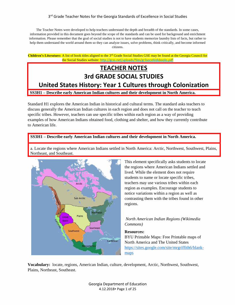
a. Locate the regions where American Indians settled in North America: Arctic, Northwest, Southwest, Plains,
Northeast, and Southeast.
This element specifically asks students to locate
the regions where American Indians settled and
lived. While the element does not require
students to name or locate specific tribes,
teachers may use various tribes within each
region as examples. Encourage students to
notice variations within a region as well as
contrasting them with the tribes found in other
regions.
North American Indian Regions (Wikimedia
Commons)
Resources:
BYU Printable Maps: Free Printable maps of
North America and The United States
https://sites.google.com/site/mrgriffith6/blank-
maps
Vocabulary: locate, regions, American Indian, culture, development, Arctic, Northwest, Southwest,
Plains, Northeast, Southeast.
3rd Grade Teacher Notes for the Georgia Standards of Excellence in Social Studies
Georgia Department of Education 4.12.2018 Page 2 of 25
American Indian tribes living in the regions listed in the standard developed and adopted unique ways to
use their environment to obtain food, clothing, and shelter. Factors such as climate and geography played
major roles in what was available for American Indians to use within the areas they inhabited. An
important aspect of this element is that it requires students to compare and contrast and not just list or
describe. To accomplish this task, students could use a variety of charts or graphs to compare and contrast
the American Indians in each region.
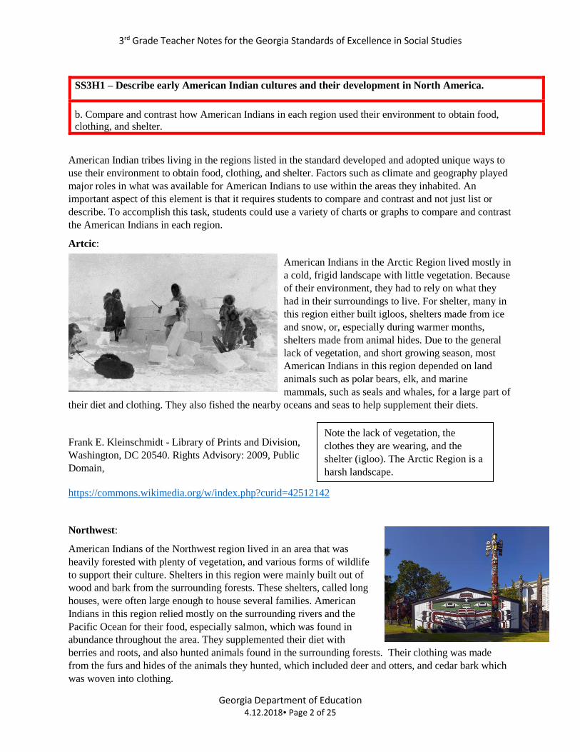
Artcic:
American Indians in the Arctic Region lived mostly in
a cold, frigid landscape with little vegetation. Because
of their environment, they had to rely on what they
had in their surroundings to live. For shelter, many in
this region either built igloos, shelters made from ice
and snow, or, especially during warmer months,
shelters made from animal hides. Due to the general
lack of vegetation, and short growing season, most
American Indians in this region depended on land
animals such as polar bears, elk, and marine
mammals, such as seals and whales, for a large part of
their diet and clothing. They also fished the nearby oceans and seas to help supplement their diets.
Frank E. Kleinschmidt - Library of Prints and Division,
Washington, DC 20540. Rights Advisory: 2009, Public
Domain,
https://commons.wikimedia.org/w/index.php?curid=42512142
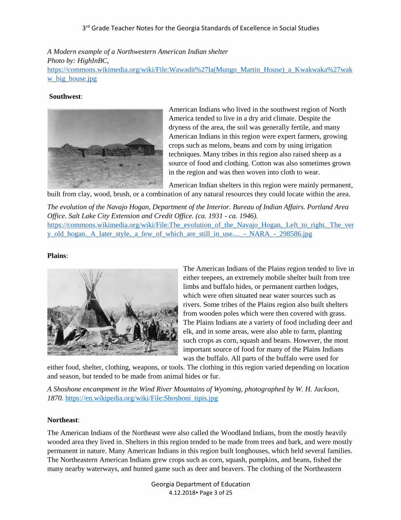
Northwest:
American Indians of the Northwest region lived in an area that was
heavily forested with plenty of vegetation, and various forms of wildlife
to support their culture. Shelters in this region were mainly built out of
wood and bark from the surrounding forests. These shelters, called long
houses, were often large enough to house several families. American
Indians in this region relied mostly on the surrounding rivers and the
Pacific Ocean for their food, especially salmon, which was found in
abundance throughout the area. They supplemented their diet with
berries and roots, and also hunted animals found in the surrounding forests. Their clothing was made
from the furs and hides of the animals they hunted, which included deer and otters, and cedar bark which
was woven into clothing.
SS3H1 – Describe early American Indian cultures and their development in North America.
b. Compare and contrast how American Indians in each region used their environment to obtain food,
clothing, and shelter.
Note the lack of vegetation, the
clothes they are wearing, and the
shelter (igloo). The Arctic Region is a
harsh landscape.
3rd Grade Teacher Notes for the Georgia Standards of Excellence in Social Studies
Georgia Department of Education 4.12.2018 Page 3 of 25
A Modern example of a Northwestern American Indian shelter
Photo by: HighInBC,
https://commons.wikimedia.org/wiki/File:Wawadit%27la(Mungo_Martin_House)_a_Kwakwaka%27wak
w_big_house.jpg
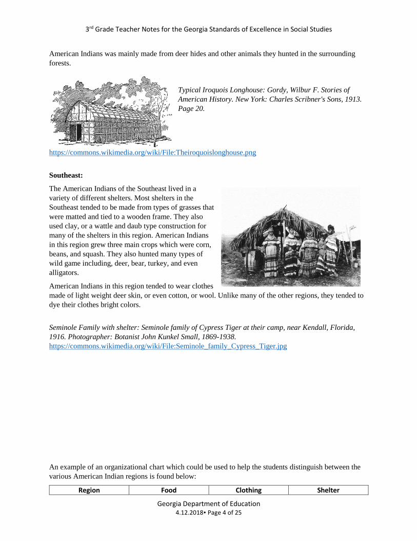
Southwest:
American Indians who lived in the southwest region of North
America tended to live in a dry arid climate. Despite the
dryness of the area, the soil was generally fertile, and many
American Indians in this region were expert farmers, growing
crops such as melons, beans and corn by using irrigation
techniques. Many tribes in this region also raised sheep as a
source of food and clothing. Cotton was also sometimes grown
in the region and was then woven into cloth to wear.
American Indian shelters in this region were mainly permanent,
built from clay, wood, brush, or a combination of any natural resources they could locate within the area.
The evolution of the Navajo Hogan, Department of the Interior. Bureau of Indian Affairs. Portland Area
Office. Salt Lake City Extension and Credit Office. (ca. 1931 - ca. 1946).
https://commons.wikimedia.org/wiki/File:The_evolution_of_the_Navajo_Hogan,_Left_to_right._The_ver
y_old_hogan._A_later_style,_a_few_of_which_are_still_in_use...._-_NARA_-_298586.jpg
Plains:
The American Indians of the Plains region tended to live in
either teepees, an extremely mobile shelter built from tree
limbs and buffalo hides, or permanent earthen lodges,
which were often situated near water sources such as
rivers. Some tribes of the Plains region also built shelters
from wooden poles which were then covered with grass.
The Plains Indians ate a variety of food including deer and
elk, and in some areas, were also able to farm, planting
such crops as corn, squash and beans. However, the most
important source of food for many of the Plains Indians
was the buffalo. All parts of the buffalo were used for
either food, shelter, clothing, weapons, or tools. The clothing in this region varied depending on location
and season, but tended to be made from animal hides or fur.
A Shoshone encampment in the Wind River Mountains of Wyoming, photographed by W. H. Jackson,
1870. https://en.wikipedia.org/wiki/File:Shoshoni_tipis.jpg
Northeast:
The American Indians of the Northeast were also called the Woodland Indians, from the mostly heavily
wooded area they lived in. Shelters in this region tended to be made from trees and bark, and were mostly
permanent in nature. Many American Indians in this region built longhouses, which held several families.
The Northeastern American Indians grew crops such as corn, squash, pumpkins, and beans, fished the
many nearby waterways, and hunted game such as deer and beavers. The clothing of the Northeastern
3rd Grade Teacher Notes for the Georgia Standards of Excellence in Social Studies
Georgia Department of Education 4.12.2018 Page 4 of 25
American Indians was mainly made from deer hides and other animals they hunted in the surrounding
forests.
Typical Iroquois Longhouse: Gordy, Wilbur F. Stories of
American History. New York: Charles Scribner's Sons, 1913.
Page 20.
https://commons.wikimedia.org/wiki/File:Theiroquoislonghouse.png
Southeast:
The American Indians of the Southeast lived in a
variety of different shelters. Most shelters in the
Southeast tended to be made from types of grasses that
were matted and tied to a wooden frame. They also
used clay, or a wattle and daub type construction for
many of the shelters in this region. American Indians
in this region grew three main crops which were corn,
beans, and squash. They also hunted many types of
wild game including, deer, bear, turkey, and even
alligators.
American Indians in this region tended to wear clothes
made of light weight deer skin, or even cotton, or wool. Unlike many of the other regions, they tended to
dye their clothes bright colors.
Seminole Family with shelter: Seminole family of Cypress Tiger at their camp, near Kendall, Florida,
1916. Photographer: Botanist John Kunkel Small, 1869-1938.
https://commons.wikimedia.org/wiki/File:Seminole_family_Cypress_Tiger.jpg
An example of an organizational chart which could be used to help the students distinguish between the
various American Indian regions is found below:
Region Food Clothing Shelter
3rd Grade Teacher Notes for the Georgia Standards of Excellence in Social Studies
Georgia Department of Education 4.12.2018 Page 5 of 25
Arctic
Northwest
Southwest
Plains
Northeast
Southeast
Resources:
Canada’s First People: A site dedicated to the American Indians of Canada includes information
concerning the Arctic and Northwest Regions. http://firstpeoplesofcanada.com/fp_groups/fp_inuit3.html
Mr. Donn’s First Nations of North America: A site which includes information on all the American
Indian Regions listed in the standards. http://nativeamericans.mrdonn.org/index.html
Annenberg Learner Indians: Another site which examines all of the listed regions and includes some
photographs, maps, and diagrams. http://www.learner.org/interactives/historymap/indians.html
National Archives: Pictures of American Indians doing various activities and of their homes.
https://www.archives.gov/research/native-americans/pictures#index
Readworks.org: Various Lexile leveled articles on American Indians.
http://www.readworks.org/rw/native-american-heritage-month
Native American Houses: A site that lists ten different styles of houses built by the various American
Indian tribes. Includes photographs and paintings of shelters. http://www.native-
languages.org/houses.htm
Vocabulary: compare, contrast, environment, food, clothing, shelter
SS3H1 – Describe early American Indian cultures and their development in North America.
c. Discuss how American Indians continue to contribute to American life (e.g., arts, literature).
This element should be taught as a way of reducing historical stereotypes of American Indians and to
demonstrate that Indian cultures have contributed, and continue to contribute, to the overall American
culture. Teachers can use, but are not limited to, such examples, as the Navajo Code Talkers, who helped
the United States defeat Japan during World War II, and famous American Indian writers such as
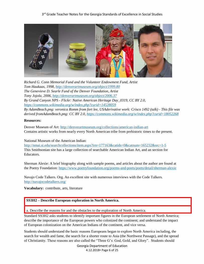
Sherman Alexie and Leslie Marmon Silko. Additionally, American Indians continue to create intricate
pieces of art such as the examples shown below, and American Indians such as Adam Beach (below right)
and Graham Green have become famous actors staring in several Hollywood movies and numerous
television shows.
3rd Grade Teacher Notes for the Georgia Standards of Excellence in Social Studies
Georgia Department of Education 4.12.2018 Page 6 of 25
Richard G. Conn Memorial Fund and the Volunteer Endowment Fund, Artist
Tom Haukaas, 1998, http://denverartmuseum.org/object/1999.80
The Genevieve D. Searle Fund of the Denver Foundation, Artist
Tony Jojola, 2006, http://denverartmuseum.org/object/2006.37
By Grand Canyon NPS - Flickr: Native American Heritage Day_0319, CC BY 2.0,
https://commons.wikimedia.org/w/index.php?curid=14528059
By AdamBeach.png: veronica Romm from fort lee, USAderivative work: Crisco 1492 (talk) - This file was
derived fromAdamBeach.png: CC BY 2.0, https://commons.wikimedia.org/w/index.php?curid=18052268
Resources:
Denver Museum of Art: http://denverartmuseum.org/collections/american-indian-art
Contains artistic works from nearly every North American tribe from prehistoric times to the present.
National Museum of the American Indian:
http://nmai.si.edu/searchcollections/item.aspx?irn=177163&catids=0&catnum=165232&src=1-5
This Smithsonian site has a large collection of searchable American Indian Art, and an section for
Educators.
Sherman Alexie: A brief biography along with sample poems, and articles about the author are found at
the Poetry Foundation: https://www.poetryfoundation.org/poems-and-poets/poets/detail/sherman-alexie
Navajo Code Talkers. Org. An excellent site with numerous interviews with the Code Talkers.
http://navajocodetalkers.org/
Vocabulary: contribute, arts, literature
SS3H2 – Describe European exploration in North America.
a. Describe the reasons for and the obstacles to the exploration of North America.
Standard SS3H2 asks students to identify important figures in the European settlement of North America;
describe the importance of the European powers who colonized the continent; and understand the impact
of European colonization on the American Indians of the continent, and vice versa.
Students should understand the basic reasons Europeans began to explore North America including, the
search for wealth and fame, the search for a shorter route to Asia (the Northwest Passage), and the spread
of Christianity. These reasons are also called the “Three G’s: God, Gold, and Glory”. Students should
3rd Grade Teacher Notes for the Georgia Standards of Excellence in Social Studies
Georgia Department of Education 4.12.2018 Page 7 of 25
also be able to describe the obstacles or hardships that European explorers faced, including lack of
funding, distance of travel, exploring unknown lands, and often times, the interaction with hostile natives.
Resources:
Exploration of North America: Provides background information about several of the listed explorers in
SS3H2b, and the reasons why their specific countries sent them to explore.
http://www.history.com/topics/exploration/exploration-of-north-america
Vocabulary: European, exploration, reasons, obstacles, North America
SS3H2 – Describe European exploration in North America.
b. Describe the accomplishments of: John Cabot (England), Vasco Núñez de Balboa (Spain), Hernando de
Soto (Spain), Christopher Columbus (Spain), Henry Hudson (The Netherlands), and Jacques Cartier (France).
Students must be familiar with these listed figures and be able to describe (at a basic level) their
contributions to the European settlement of North America. If desired,
students can learn about additional European explorers. It would be helpful
prior to beginning this standard to use maps or globes (both those from the 15th
and 16th centuries) to locate England, Spain, the Netherlands, and France.
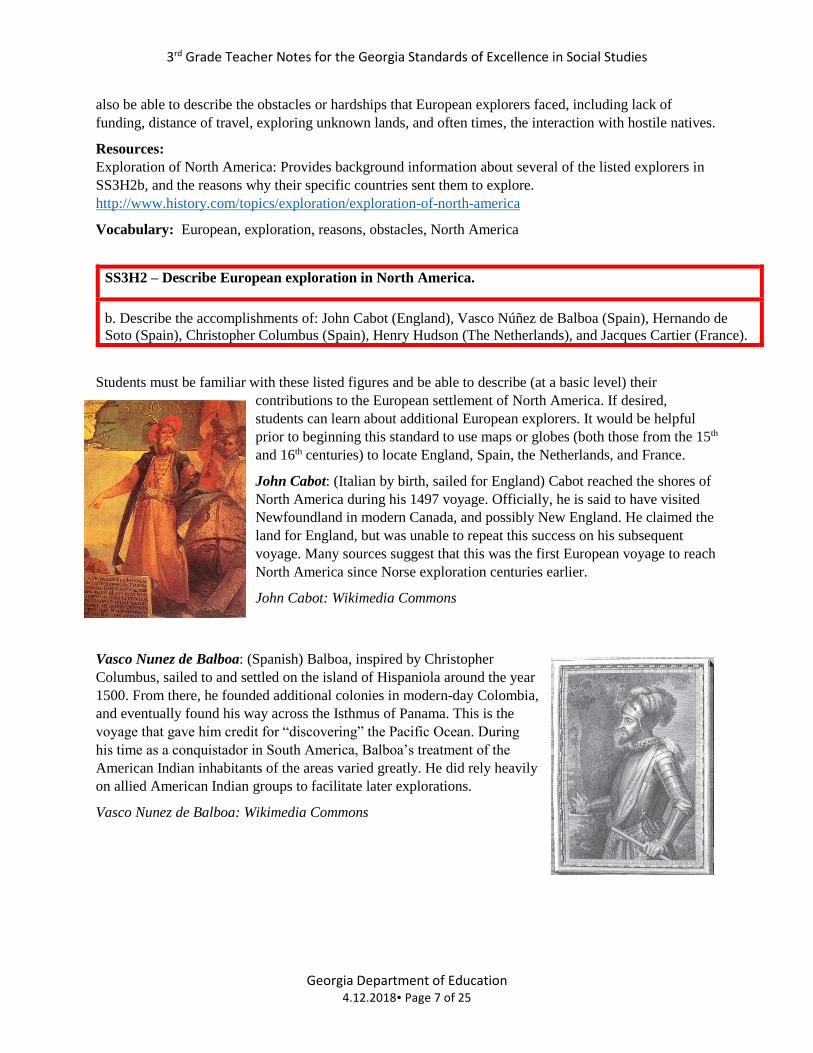
John Cabot: (Italian by birth, sailed for England) Cabot reached the shores of
North America during his 1497 voyage. Officially, he is said to have visited
Newfoundland in modern Canada, and possibly New England. He claimed the
land for England, but was unable to repeat this success on his subsequent
voyage. Many sources suggest that this was the first European voyage to reach
North America since Norse exploration centuries earlier.
John Cabot: Wikimedia Commons
Vasco Nunez de Balboa: (Spanish) Balboa, inspired by Christopher
Columbus, sailed to and settled on the island of Hispaniola around the year
1500. From there, he founded additional colonies in modern-day Colombia,
and eventually found his way across the Isthmus of Panama. This is the
voyage that gave him credit for “discovering” the Pacific Ocean. During
his time as a conquistador in South America, Balboa’s treatment of the
American Indian inhabitants of the areas varied greatly. He did rely heavily
on allied American Indian groups to facilitate later explorations.
Vasco Nunez de Balboa: Wikimedia Commons
3rd Grade Teacher Notes for the Georgia Standards of Excellence in Social Studies
Georgia Department of Education 4.12.2018 Page 8 of 25
Hernando de Soto: (Spain) De Soto began exploring at the age of 14, joining other Spanish explorers
searching for fame and fortune in the New World. By the age of thirty, de Soto had settled in modern day
Central America, making a fortune in the slave trade. After expanding
his wealth by helping to conquer the gold rich Incas in South America
(Peru), de Soto returned to Spain in 1536 an extremely rich man. Two
years later de Soto headed back to North America and explored present
day Florida, Georgia, the Carolinas, Tennessee, Alabama, Louisiana,
and Arkansas in search of gold. De Soto’s travel through the Southeast
led to continual battles with many of the American Indians he and his
men encountered. He was a brutal conqueror, killing, or capturing and
enslaving many of the American Indian tribes with whom he came in
contact. He is also blamed for the decimation of many of those same
tribes who eventually succumbed to a variety of the European diseases
de Soto’s men carried with them. After three years of exploring, de Soto
died near the Mississippi River, having never found the wealth he was
searching for in his last expedition.
Hernando de Soto, Wikimedia Commons
Christopher Columbus: (Italian, sailed for Spain) It is nearly impossible to
succinctly summarize the impact of Columbus and his voyages on modern
North America, and the transition that his legacy has undergone in recent
years. Students should know that Columbus did not “discover” America,
and that most educated Europeans were well aware of the curvature of the
Earth before his first expedition in 1492. Columbus should be noted as
making four trips to the “New World”, and not just one. Columbus may be
credited with establishing lasting European colonies in the Americas (the
Caribbean), and his explorations led to permanent European interest in the
area, even though the islands he claimed were not the East Indies, as he
initially thought.
Christopher Columbus, Wikimedia Commons
Henry Hudson: (English, sailed for England and Holland) Hudson’s
quest for a Northwest Passage from Europe to China began in 1607. His
Arctic route proved unsuccessful, though he did explore the area around
what is today New York City, and eventually sailed up the Hudson River.
Later voyages took him into modern Hudson Bay, but he was unable to
find a way further west. Hudson’s desire to continue searching for the
elusive (and ultimately non-existent) passage under harsh Arctic
conditions led to a mutiny of his crew on his final 1610 voyage, and he
was set adrift, never to be seen again. Teachers should note that most of
Hudson’s early life is lost to history, and be wary of sources accordingly.
Henry Hudson, Wikimedia Commons
3rd Grade Teacher Notes for the Georgia Standards of Excellence in Social Studies
Georgia Department of Education 4.12.2018 Page 9 of 25
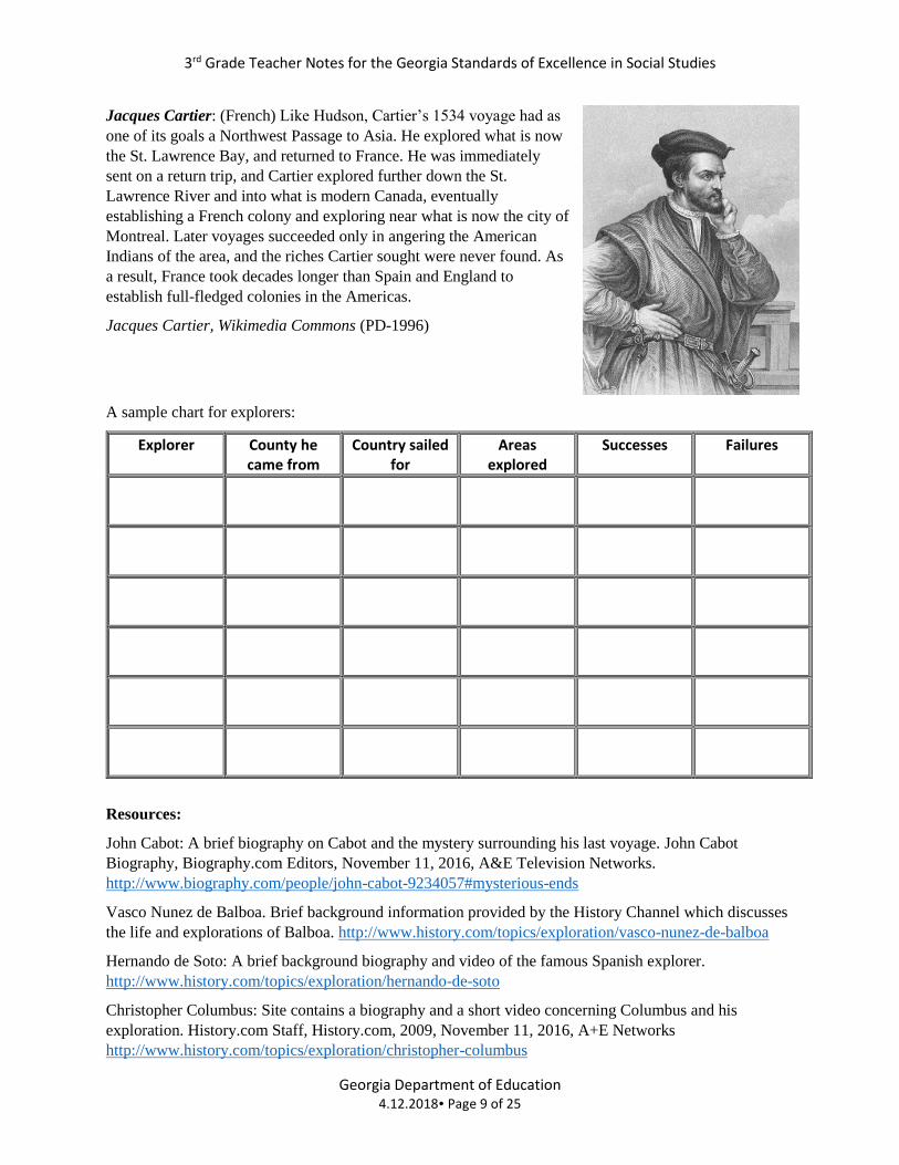
Jacques Cartier: (French) Like Hudson, Cartier’s 1534 voyage had as
one of its goals a Northwest Passage to Asia. He explored what is now
the St. Lawrence Bay, and returned to France. He was immediately
sent on a return trip, and Cartier explored further down the St.
Lawrence River and into what is modern Canada, eventually
establishing a French colony and exploring near what is now the city of
Montreal. Later voyages succeeded only in angering the American
Indians of the area, and the riches Cartier sought were never found. As
a result, France took decades longer than Spain and England to
establish full-fledged colonies in the Americas.
Jacques Cartier, Wikimedia Commons (PD-1996)
A sample chart for explorers:
Explorer County he came from
Country sailed for
Areas explored
Successes Failures
Resources:
John Cabot: A brief biography on Cabot and the mystery surrounding his last voyage. John Cabot
Biography, Biography.com Editors, November 11, 2016, A&E Television Networks.
http://www.biography.com/people/john-cabot-9234057#mysterious-ends
Vasco Nunez de Balboa. Brief background information provided by the History Channel which discusses
the life and explorations of Balboa. http://www.history.com/topics/exploration/vasco-nunez-de-balboa
Hernando de Soto: A brief background biography and video of the famous Spanish explorer.
http://www.history.com/topics/exploration/hernando-de-soto
Christopher Columbus: Site contains a biography and a short video concerning Columbus and his
exploration. History.com Staff, History.com, 2009, November 11, 2016, A+E Networks
http://www.history.com/topics/exploration/christopher-columbus
3rd Grade Teacher Notes for the Georgia Standards of Excellence in Social Studies
Georgia Department of Education 4.12.2018 Page 10 of 25
Henry Hudson. The History Channel provides a brief biography and video for teacher background
information. http://www.history.com/topics/exploration/henry-hudson
Jacques Cartier: A brief biography and video concerning the French explorer of Canada.
http://www.biography.com/people/jacques-cartier-9240128
Vocabulary: accomplishments, John Cabot, Vasco Núñez de Balboa, Hernando de Soto, Christopher
Columbus, Henry Hudson, Jacques Cartier
SS3H2 – Describe European exploration in North America.
c. Describe examples of cooperation and conflict between European explorers and American Indians.
For this element, students should focus on examples of cooperation and conflict between the Europeans
specifically mentioned in standard SS3H2b and the American Indians they encountered.
Teachers should provide information about the context in which American Indians and Europeans
interacted (trade, migration, colonization, etc.). For instance, the Spanish wanted to find gold and to
spread Christianity, the French wanted to develop a profitable fur trade, the English wanted to colonize to
grow cash crops, the American Indians wanted to trade for technology and manufactured items. These
desires shaped the relationship of each group with the natives in their region.
Some American Indians groups initially helped European settlers find and grow food (Thanksgiving), and
adopt to their new environment, however European ideas about land and property ownership conflicted
with those of the American Indians and the relationships often became strained and even violent.
Resources:
Teaching History.org: A brief description of the interaction between American Indians and the Spanish,
French, and Dutch. Great background information for teachers: http://teachinghistory.org/history-
content/ask-a-historian/25447
For information about Columbus and Native Americans visit:
http://www.history.com/topics/exploration/columbus-controversy
To see an example of interaction between the Jamestown colony and the Powhatan people visit:
http://www.historyisfun.org/jamestown-settlement/powhatan-village/pocahontas-and-the-powhatans-of-
virginia/
Plimoth Planation: Learn about one of the earliest interactions between Europeans and the Wampanoag.
Many great activities and ideas concerning the interaction of two cultures.
https://www.plimoth.org/learn/just-kids
Vocabulary: examples, cooperation, conflict
3rd Grade Teacher Notes for the Georgia Standards of Excellence in Social Studies
Georgia Department of Education 4.12.2018 Page 11 of 25
SS3H3 Explain the factors that shaped British Colonial America.
a. Identify key reasons why the New England, Mid-Atlantic, and Southern colonies were founded (religious
freedom and profit).
New England: Most of the colonies in the New England region were founded by people searching for
new lands to settle in which they could practice their own religious beliefs. The Pilgrims and the Puritans
are both examples of religious groups who escaped persecution in England for the relative safety of New
England. Rhode Island was also founded for religious freedom by people voluntarily leaving or by being
banished from the early Puritans’ strict and intolerant religious beliefs. For much of the settlement period,
religion and government were one in the same. New Hampshire was the only colony in New England
settled primarily for economic reasons, and was used initially as a base for fishing.
Mid-Atlantic: Unlike the New England colonies, the Mid-Atlantic colonies tended to be much more
tolerant towards different religious practices compared to the other regions and had a wide variety of
religions present including Quakers, Lutherans, and Presbyterians. The Mid-Atlantic region also had the
advantage of having rich fertile soil for farming, eventually becoming the “bread basket” of the colonies.
Southern: The Southern colonies were mainly founded for economic reasons. Beginning with the early
successful cultivation of tobacco in the Virginia colony, the land throughout the Southern colonies was
eventually turned into large plantations, where tobacco, corn, indigo, and rice were grown in large
quantities. Cotton would become a major cash crop in the early 1800s, after the invention of the cotton
gin.
Resources:
The Gilder Lehrman Institute of American History: Colonization and Settlement, 1585-1763, A brief
background article on why and how Europeans settled in North America. Written by historian John
Demos. https://www.gilderlehrman.org/history-by-era/essays/colonization-and-settlement-
1585%E2%80%931763
History Channel: The 13 Colonies: Article and short video on the founding of the 13 Colonies with
information divided up by region. http://www.history.com/topics/thirteen-colonies
Religion and the Founding of the American Republic: A helpful essay on religion and the colonial period.
http://www.loc.gov/exhibits/religion/rel01.html
Vocabulary: New England colonies, Mid-Atlantic colonies, Southern colonies, religious freedom, profit
SS3H3 Explain the factors that shaped British Colonial America.
b. Compare and contrast colonial life in the New England, Mid-Atlantic, and Southern colonies (education,
economy, and religion).
For this element, students should be able to explain how the location of the colonies shaped their culture,
politics, and economy, and be able to compare them on that basis.
New England:
Because the climate in this region is harsh, farms were small and most agricultural families grew just
enough for themselves. Shipping, commerce and manufacturing were important economic forces. Some
3rd Grade Teacher Notes for the Georgia Standards of Excellence in Social Studies
Georgia Department of Education 4.12.2018 Page 12 of 25
of these colonies were founded by groups such as the Puritans and Pilgrims, who sought freedom to
express their religious beliefs. They had been persecuted in Europe, and yet were not very tolerant of
other religions in their own newly established colonies. Even in the earliest colonial days, town
governments were established, and the rule of law was very important. Citizens were often given input
into local government decisions. This became even more important when Britain limited colonial political
participation in the late colonial period.
Mid-Atlantic:
Considered the “breadbasket” of the colonies, the staple crops of this region were grains. Also important
were fishing and shipping, but there was significantly less manufacturing than in New England. A wide
variety of religious traditions were present. Pennsylvania was settled by Quakers seeking religious
freedom, and colonial governments varied widely in their organization and influence.
Southern:
Due to the rich soil and mild climate in the Southern colonies, the backbone of the economy was based on
free/cheap labor (slaves and indentured servants) and cash crops such as tobacco and rice—cotton did not
become profitable until the invention of the cotton gin in the 1790’s. There was very little industry
outside of what was needed to keep plantations running, and Southern colonies were dependent upon
outside sources to ship their goods abroad. Because people tended to live far from each other, local
governments held less sway with colonists than in other regions.
Resources:
Everyday American, Exceptional Americans: A Teaching American History Project: Background
information and a lesson based on comparing and contrasting the three colonial regions. This activity was
developed for middle school, but can easily be tailored for the elementary level. http://chnm.gmu.edu/tah-
loudoun/blog/lessons/colonial-life-comparecontrast/
Mr. Nussbaum’s Colonial Regions: Gives a brief description of each of the three regions, and provides
corresponding activities. http://mrnussbaum.com/13regions/
Vocabulary: colonial life, education, economy, religion
SS3H3 Explain the factors that shaped British Colonial America.
c. Describe colonial life in America from the perspectives of various people: large landowners, farmers,
artisans, women, children, indentured servants, slaves, and American Indians.
For this element, students should be able to describe the typical lifestyle of members of each of the
following groups. Note that these are generalizations and that exceptions to nearly every statement listed
certainly existed.
Large landowners: Most large landowners lived in the Southern colonies, where fertile soil and
temperate climates made cash crop farming successful. These landowners relied on cheap/free labor
(initially indentured servants, then enslaved persons) to produce their crops and keep their
plantations/farms running. Large landowners tended to hold a greater amount of power and wealth
compared to others in their communities.
Farmers: There was no single type of “farmer” in colonial America. Smaller, family farms were found in
all three regions. Particularly in the Mid-Atlantic region, some family farms were large enough to produce
3rd Grade Teacher Notes for the Georgia Standards of Excellence in Social Studies
Georgia Department of Education 4.12.2018 Page 13 of 25
crops for sale. In general, smaller farmers were self-sufficient, and therefore susceptible to adverse
weather, armed conflict with American Indians along the moving frontier, and governmental whims.
Artisans: Artisans, people skilled in trades (e.g., blacksmiths, butchers, millers, gunsmiths, and printers)
were found in all three regions, though their lifestyles differed greatly. In the New England and Mid-
Atlantic colonies, these skills helped artisans live comfortably and independently, as the concentrations of
people in towns and cities sent customers to them. In the Southern colonies, many artisans were actually
enslaved and worked for their “owners,” or were leased by their “owners” to other large landowners.
Women: While the exact work required of them varied greatly by economic class, few colonial women
enjoyed the privileges of modern women. Unable to vote, and often excluded from any sort of “public”
life, women were typically viewed as living in a separate sphere of home and family. Women from poorer
families or enslaved women were typically expected to work physically as hard as any man, while still
maintaining a home and family life.
Indentured servants: These were people who came to the colonies without funds necessary for their
voyages across the Atlantic. In exchange for paying for these servants’ passage, larger farmers and
landowners would receive a set term (indenture) of labor without payment. While some farmers treated
these indentured servants fairly and honored their agreements, many others took advantage of this
situation and held their indentured servants in virtual slavery. Over time, the discontented state of most
indentured servants helped increase the slave trade and reliance on enslaved laborers.
Slaves: While most students will think of people being enslaved on large Southern plantations, there were
also people enslaved in the Mid-Atlantic and New England colonies – including in urban areas. For these
people, there were no personal or economic freedoms, and treatment was typically quite cruel. In
addition, enslaved people were deprived of the opportunity to educate themselves or maintain their family
structure. (This became worse following the American Revolution.) Students should be made aware that
the emancipation movement did begin early in the colonial period, and gained steam in the 19th century.
They should also learn that there were free people of color, particularly in northern cities, and that not all
people of African ancestry were enslaved.
American Indians: The original inhabitants of all of colonial America were subjected to numerous failed
treaties and attacks at the hands of the British settlers. What are widely known as the “Indian wars”
continued in varying places for most of the colonial period and into the first century of American
independence. While a tiny minority of American Indians continued to live on their traditional lands,
most were pushed far west toward (and then past) the Appalachian Mountains. Traditional lifestyles
eroded, and many American Indians took on characteristics of the settlers around them; many settlers also
began to emulate the American Indian lifestyle in terms of agriculture, hunting, clothing, and other factors
that let them succeed in unfamiliar terrain. Students should learn that there was (and is) no single
“American Indian” culture, and as much as is possible, teachers should guide their students to learn about
specific American Indians nations or tribes.
Resources:
Colonial Williamsburg: Experience the Life: A site that provides a variety of information about colonial
social classes, slavery, and family. http://www.history.org/Almanack/life/
U.S.History.org: Easy to find information about any time period in U.S. History, including the colonial
period. http://www.ushistory.org/us/3.asp
Vocabulary: colonial life, perspectives, landowners, farmers, artisans, women, children, indentured
servants, slaves, American Indians.
3rd Grade Teacher Notes for the Georgia Standards of Excellence in Social Studies
Georgia Department of Education 4.12.2018 Page 14 of 25
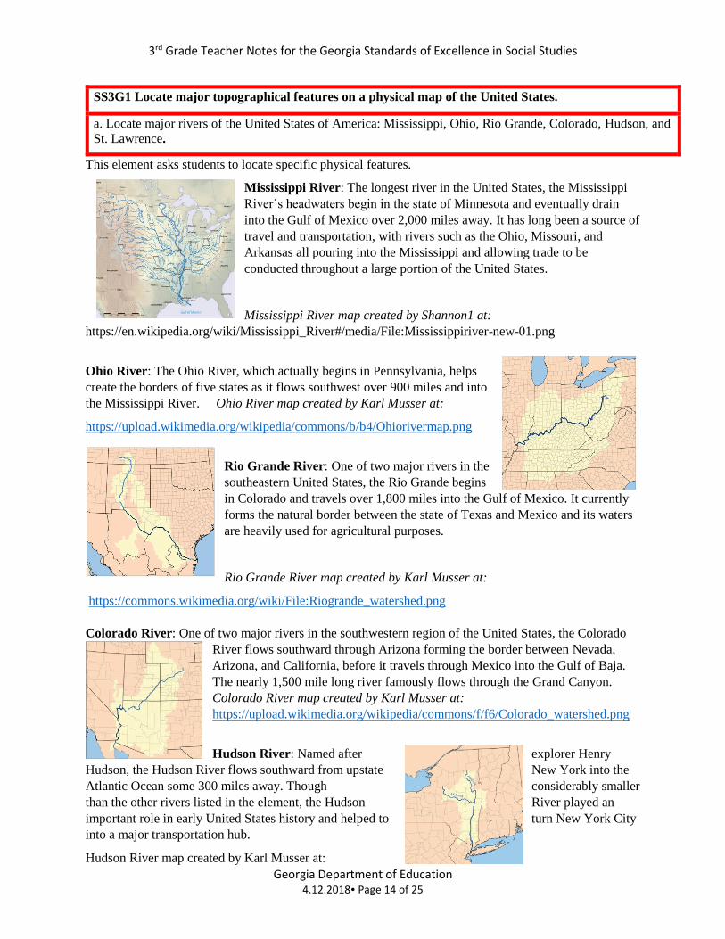
SS3G1 Locate major topographical features on a physical map of the United States.
a. Locate major rivers of the United States of America: Mississippi, Ohio, Rio Grande, Colorado, Hudson, and
St. Lawrence.
This element asks students to locate specific physical features.
Mississippi River: The longest river in the United States, the Mississippi
River’s headwaters begin in the state of Minnesota and eventually drain
into the Gulf of Mexico over 2,000 miles away. It has long been a source of
travel and transportation, with rivers such as the Ohio, Missouri, and
Arkansas all pouring into the Mississippi and allowing trade to be
conducted throughout a large portion of the United States.
Mississippi River map created by Shannon1 at:
https://en.wikipedia.org/wiki/Mississippi_River#/media/File:Mississippiriver-new-01.png
Ohio River: The Ohio River, which actually begins in Pennsylvania, helps
create the borders of five states as it flows southwest over 900 miles and into
the Mississippi River. Ohio River map created by Karl Musser at:
https://upload.wikimedia.org/wikipedia/commons/b/b4/Ohiorivermap.png
Rio Grande River: One of two major rivers in the
southeastern United States, the Rio Grande begins
in Colorado and travels over 1,800 miles into the Gulf of Mexico. It currently
forms the natural border between the state of Texas and Mexico and its waters
are heavily used for agricultural purposes.
Rio Grande River map created by Karl Musser at:
https://commons.wikimedia.org/wiki/File:Riogrande_watershed.png
Colorado River: One of two major rivers in the southwestern region of the United States, the Colorado
River flows southward through Arizona forming the border between Nevada,
Arizona, and California, before it travels through Mexico into the Gulf of Baja.
The nearly 1,500 mile long river famously flows through the Grand Canyon.
Colorado River map created by Karl Musser at:
https://upload.wikimedia.org/wikipedia/commons/f/f6/Colorado_watershed.png
Hudson River: Named after explorer Henry
Hudson, the Hudson River flows southward from upstate New York into the
Atlantic Ocean some 300 miles away. Though considerably smaller
than the other rivers listed in the element, the Hudson River played an
important role in early United States history and helped to turn New York City
into a major transportation hub.
Hudson River map created by Karl Musser at:
3rd Grade Teacher Notes for the Georgia Standards of Excellence in Social Studies
Georgia Department of Education 4.12.2018 Page 15 of 25
https://upload.wikimedia.org/wikipedia/commons/7/7d/Hudsonmap.png
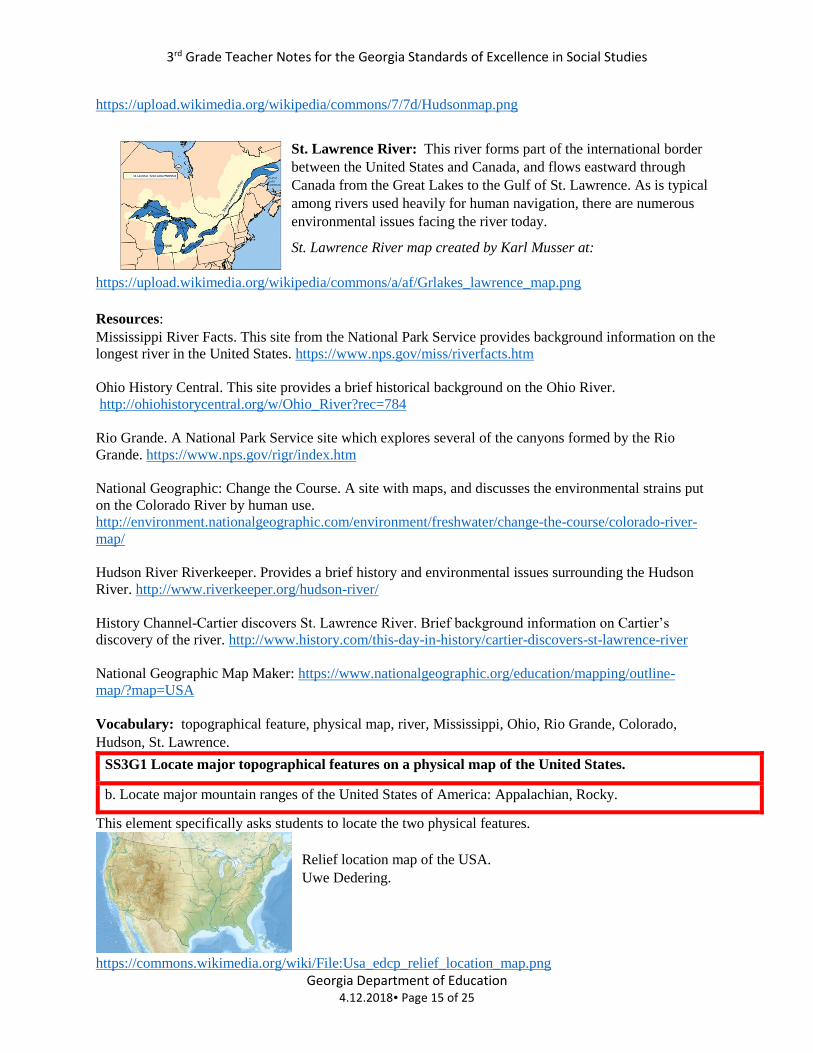
St. Lawrence River: This river forms part of the international border
between the United States and Canada, and flows eastward through
Canada from the Great Lakes to the Gulf of St. Lawrence. As is typical
among rivers used heavily for human navigation, there are numerous
environmental issues facing the river today.
St. Lawrence River map created by Karl Musser at:
https://upload.wikimedia.org/wikipedia/commons/a/af/Grlakes_lawrence_map.png
Resources:
Mississippi River Facts. This site from the National Park Service provides background information on the
longest river in the United States. https://www.nps.gov/miss/riverfacts.htm
Ohio History Central. This site provides a brief historical background on the Ohio River.
http://ohiohistorycentral.org/w/Ohio_River?rec=784
Rio Grande. A National Park Service site which explores several of the canyons formed by the Rio
Grande. https://www.nps.gov/rigr/index.htm
National Geographic: Change the Course. A site with maps, and discusses the environmental strains put
on the Colorado River by human use.
http://environment.nationalgeographic.com/environment/freshwater/change-the-course/colorado-river-
map/
Hudson River Riverkeeper. Provides a brief history and environmental issues surrounding the Hudson
River. http://www.riverkeeper.org/hudson-river/
History Channel-Cartier discovers St. Lawrence River. Brief background information on Cartier’s
discovery of the river. http://www.history.com/this-day-in-history/cartier-discovers-st-lawrence-river
National Geographic Map Maker: https://www.nationalgeographic.org/education/mapping/outline-
map/?map=USA
Vocabulary: topographical feature, physical map, river, Mississippi, Ohio, Rio Grande, Colorado,
Hudson, St. Lawrence.
SS3G1 Locate major topographical features on a physical map of the United States.
b. Locate major mountain ranges of the United States of America: Appalachian, Rocky.
This element specifically asks students to locate the two physical features.
Relief location map of the USA.
Uwe Dedering.
https://commons.wikimedia.org/wiki/File:Usa_edcp_relief_location_map.png
3rd Grade Teacher Notes for the Georgia Standards of Excellence in Social Studies
Georgia Department of Education 4.12.2018 Page 16 of 25
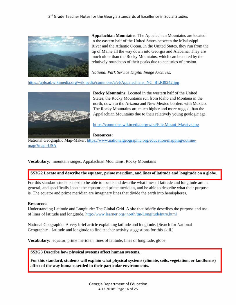
Appalachian Mountains: The Appalachian Mountains are located
in the eastern half of the United States between the Mississippi
River and the Atlantic Ocean. In the United States, they run from the
tip of Maine all the way down into Georgia and Alabama. They are
much older than the Rocky Mountains, which can be noted by the
relatively roundness of their peaks due to centuries of erosion.
National Park Service Digital Image Archives:
https://upload.wikimedia.org/wikipedia/commons/e/ef/Appalachians_NC_BLRI9242.jpg
Rocky Mountains: Located in the western half of the United
States, the Rocky Mountains run from Idaho and Montana in the
north, down to the Arizona and New Mexico borders with Mexico.
The Rocky Mountains are much higher and more rugged than the
Appalachian Mountains due to their relatively young geologic age.
https://commons.wikimedia.org/wiki/File:Mount_Massive.jpg
Resources:
National Geographic Map-Maker: https://www.nationalgeographic.org/education/mapping/outline-
map/?map=USA
Vocabulary: mountain ranges, Appalachian Mountains, Rocky Mountains
SS3G2 Locate and describe the equator, prime meridian, and lines of latitude and longitude on a globe.
For this standard students need to be able to locate and describe what lines of latitude and longitude are in
general, and specifically locate the equator and prime meridian, and be able to describe what their purpose
is. The equator and prime meridian are imaginary lines that divide the earth into hemispheres.
Resources:
Understanding Latitude and Longitude: The Global Grid. A site that briefly describes the purpose and use
of lines of latitude and longitude. http://www.learner.org/jnorth/tm/LongitudeIntro.html
National Geographic: A very brief article explaining latitude and longitude. [Search for National
Geographic + latitude and longitude to find teacher activity suggestions for this skill.]
Vocabulary: equator, prime meridian, lines of latitude, lines of longitude, globe
SS3G3 Describe how physical systems affect human systems.
For this standard, students will explain what physical systems (climate, soils, vegetation, or landforms)
affected the way humans settled in their particular environments.
3rd Grade Teacher Notes for the Georgia Standards of Excellence in Social Studies
Georgia Department of Education 4.12.2018 Page 17 of 25
a. Explain why American Indian groups occupied the areas they did (SS3H1a), with emphasis on why some
developed permanent villages and others did not.
For this element, students will explain why American Indians settled in certain areas, and decided to
create permanent or temporary settlements in the North American regions listed in SS3H1. They should
also understand that the ability to farm tended to lead to permeant settlement because they had a reliable,
constant source of food, making it unnecessary to move in search of migrating animals. Be mindful that
students do not need to learn about specific tribes, though teachers may mention specific tribes as
examples of people who lived within the stated regions.
Artcic:
Native Indians in the Arctic came to North America relatively late by traveling across the land bridge
from Asia. They settled in the cold Arctic region because other American Indian tribes were well
established to the south of them and they wanted to avoid conflicts with the already existing tribes. Due to
the cold climate, American Indian groups in this region relied on whatever resources were available to
them and tended to live in small, nomadic villages moving seasonally in search of migrating animals such
as caribou. They also hunted marine mammal and fished the local waters for food sources as well.
Northwest:
The Northwestern region of the United States has a climate that tends to be warm during the summer and
cold during the winter months, with abundant precipitation (rain or snow) year round. The area has a
wooded landscape which is broken up by rivers that flow into the Pacific Ocean. American Indians used
the heavily wooded region to hunt animals and gather berries. They also used the Pacific Ocean and the
many rivers to fish. The fishing, hunting, and gathering of food was done during the summer months by
small nomadic groups, which would then dry and store the food for the winter. During the winter months
the American Indians in this region built large houses using materials from the forests, forming small
villages. During these cold months, they mostly ate the dried food they had preserved during the summer
months.
Southwest:
American Indians who settled in the Southwest region of the United States lived in a desert climate with
little rain. Despite the dry conditions, many Southwestern American Indians were farmers, irrigating the
land with what little rainfall there was. Most of the Native Americans in the region, because they were
farmers, built permanent houses and settlements. These structures were mainly made out of sticks and
clay, both of which could be found in the region. Many in this region also used the abundant clay to
create pottery which was either used locally or traded.
Plains:
American Indians who inhabited the Plains region were nomadic in nature, were hunters, and gathered
berries and wild plants when available. In order to follow the seasonal migration of animals such as
buffalo, many American Indians in this region lived in tepees which could easily be set-up and taken
down. The Plains region provided ample grass which the buffalo could feed on, and plenty of water
sources which the tribes used for drinking and cooking.
Northeast:
Northeastern American Indians lived in a seasonal climate, which tended to be cold during the winter and
warm during the summer. They lived in heavily wooded areas and as such their shelters tended to be
made from trees, bark, and branches. These structures were usually permanent due to the fact that the
3rd Grade Teacher Notes for the Georgia Standards of Excellence in Social Studies
Georgia Department of Education 4.12.2018 Page 18 of 25
American Indians in the Northeast heavily cultivated crops such as corn, squash, and beans, and also
hunted, fished, and gathered berries in the surrounding region. Though they lived in wooded areas,
American Indians in this region would clear cut and burn trees in order to clear out an area to farm.
Southeast:
Southeastern American Indians lived in a generally warm climate, with seasonal rain. Much of the land
was very fertile, allowing many American Indians in this region to grow crops nearly year round.
Because the land was fertile and food was plentiful, the Southeastern Native Americans built permanent
homes, sometimes in very large villages. These shelters could be built out of materials that were found
locally including logs, branches, leaves, and grasses. To support the growing of crops, American Indians
in this region also hunted in the forest, fished, and gathered wild fruits and vegetables.
Resources:
Mr. Donn’s: A general history site for students which includes information all of the American Indian
regions listed in the standards. : http://nativeamericans.mrdonn.org/index.html
Annenberg Learner: A site which contains information about all the regions. The site lists specific
American Indian tribes, however the information can easily be generalized to fit within the listed
requirements. http://www.learner.org/interactives/historymap/indians.html
University of Oregon’s Mapping History: A variety of maps you are able to use in your classroom,
including one of North America. http://mappinghistory.uoregon.edu/english/US/US01-03.html
National Museum of the American Indian: A lot of information pertaining to American Indians including
many photographs and an Educator’s Newsletter. http://nmai.si.edu/
History: General information on American Indians. The site includes a few videos and photographs about
various tribes. http://www.history.com/topics/native-american-history/native-american-cultures
Vocabulary: physical systems, human systems, environments, permanent, villages
SS3G3 Describe how physical systems affect human systems.
b. Describe how the early explorers (SS3H2a) adapted, or failed to adapt, to the various physical environments
in which they traveled.
This element asks students to explain how the environments explored by each of the following people
directly contributed to the explorers’ successes and failures. In addition, students should be able to
explain in broader terms the relationship between certain geographical features and successful
exploration. {Teachers may wish to see the information included in the notes for SS4H2b for additional
information and resource links.}
John Cabot: Since first-hand information related to Cabot’s voyages is vague, some interpretation is
necessary to relate the geography of Newfoundland to his travels. Certainly, the inclement weather of the
region was an obstacle in Cabot’s attempts to reach the coastline. Since Cabot never returned from his
final voyage, it is also assumed that weather caused his ship to be lost at sea. Finally, the rocky coastline
of eastern Canada probably contributed to his limited attempts to actually land a vessel.
3rd Grade Teacher Notes for the Georgia Standards of Excellence in Social Studies
Georgia Department of Education 4.12.2018 Page 19 of 25
Vasco Nunez de Balboa: Having lived in the Caribbean/Central American region for many years,
Balboa’s familiarity with the environment and climate greatly contributed to his ability to explore new
places, and successfully to settle and live in the area. Once he crossed the Isthmus of Panama, he located
the fabled “South Sea,” now known as the Pacific Ocean.
Hernando de Soto: Having spent much of his early years helping to explore tropical areas such as
Columbia and Peru, the summer climate of the Southeastern United States presented few problems for de
Soto and his men. The cooler months however, usually drove him and his men into American Indian
encampments, where they would take up camp and steal their food supplies, causing ongoing issues with
the American Indians with whom he came in contact.
Christopher Columbus: Columbus found himself in unfamiliar and uncharted territory as he searched
for a water route to Asia. However, because of his southern route, he landed in the hospitable Caribbean,
as opposed to the frigid arctic. As with all sea voyages, the weather was the most potent threat, and one
voyage faced such a severe storm that Columbus himself thought that they would be lost at sea.
Henry Hudson: Wanting to find a passage across Canada, Hudson’s northerly voyages were greatly
affected by the harsh weather of the area. In addition, the simple fact that the passage did not exist made
the voyages treacherous, as the terrain was not friendly to ocean-going vessels, nor were the numerous
icebergs in the area easy to avoid. Ultimately, his crew grew tired of dealing with these conditions, and
mutinied, setting Hudson, his son, and several crew members adrift, never to be heard from again.
Jacques Cartier: Cartier’s search for a western route (Northwest Passage) to Asia encountered numerous
obstacles due to his ignorance about the climate of the region to which he sailed. At one point, his crew
encountered rapids that rendered the river on which they sailed unnavigable. This led to a decision to
spend the winter in a newly built fort; unfortunately, they were not prepared for the Canadian winter, and
were it not for the help of nearby Iroquois, it is likely they would all have perished.
Resources:
Bio: A series of short biographers describing the journeys to North America.
http://www.biography.com/people/groups/famous-explorers
Vocabulary: adapt (adapted, adaptation)
SS3G3 Describe how physical systems affect human systems.
c. Explain how the physical geography of the New England, Mid-Atlantic, and Southern colonies helped
determine economic activities.
For this element, students should explain the major geographic features that distinguish each region, and
then specifically link those features to the prominent economic activities of each region.
New England: Because most soil in New England is rocky and poorly suited for large-scale agriculture,
farms were small and few people practiced more than subsistence agriculture. The close proximity of
most towns to the coast made shipping, fishing, and whaling essential economic activities. In later years,
as the world industrialized, the region was also home to many factories due to the presence of raw
3rd Grade Teacher Notes for the Georgia Standards of Excellence in Social Studies
Georgia Department of Education 4.12.2018 Page 20 of 25
materials, adequate population growth for factory work, and access to shipping points to other colonies
and back to Europe.
Mid-Atlantic: Many farms in the Mid-Atlantic region were large, and the crops grown reflected the high
quality of the soil. Fishing and shipping were still important, and the cities in the region were home to
many different artisanal economic activities, supporting extensive specialization.
Southern: With less concentrated population than the other colonies, the large farms that thrived on the
rich soil of many of these colonies required the importation of labor. In addition, the larger size of the
colonies made transportation more difficult. There were a few large ports for shipping in each of the
Southern colonies, and a small economy developed that allowed agricultural goods to be transported from
the interior to these ports.
Resources:
The Thirteen Original Colonies: Basic background information which discusses the climate, geographic
features, soil, natural resources, and other features from each of the three colonial regions.
http://original13colonies.weebly.com/new-england-colonies.html
Vocabulary: physical geography, economic activity
SS3CG1: Describe the elements of representative democracy/republic in the United States.
a. Describe the three branches of national government: executive (president), legislative (Congress), and
judicial (Supreme Court of the United States).
For this element students need to describe the three branches of the national government.
-Executive: For 3rd grade standards, students need only to know that the head of the executive branch is
the president. In addition to the president, you can explain that the executive branch also includes the
vice-president, and the cabinet, all of whom provide advice to the president. The President is the head of
the United States government and shares power with the other two branches. The President is also the
commander in chief of the military.
-Legislative: Here students need only to know that the legislative branch consists of the Congress. You
can extend this to have them also understand that Congress is made up of two parts: the Senate and the
House of Representatives, and that they too share power with the other two branches. The Senate consists
of 100 members, two from each state, while the House of Representatives has 435 members, with the
number of representatives per state determined by each state’s population.
-Judicial: Students need to understand that the Judicial Branch is made up of the Supreme Court of the
United States. The Judicial Branch also consists of other Federal Courts located throughout the United
States. The Supreme Court is the highest court in the United States.
Vocabulary: representative democracy/republic, branches, national, government, executive, legislative,
judicial, courts, president, representative, senator, Congress, population
3rd Grade Teacher Notes for the Georgia Standards of Excellence in Social Studies
Georgia Department of Education 4.12.2018 Page 21 of 25
SS3CG1: Describe the elements of representative democracy/republic in the United States.
b. Describe the three branches of state government: executive (governor), legislative (Georgia General
Assembly), and judicial (Supreme Court of Georgia).
Students need to describe the three branches of state government. Georgia’s first constitution was written
in 1777 and created the three branches of Georgia government.
-Executive: The students need to understand that at the state level, the governor is the head of our state’s
government. The state executive branch is made up of the governor, lieutenant governor, and other
agencies.
-Legislative: The legislative branch in Georgia is called the General Assembly and has been in
continuous operation since 1777. Like the legislative branch at the national level, the state General
Assembly consists of two parts, the House of Representatives and the Senate.
-Judicial: The judicial branch in Georgia is made up of the Supreme Court of Georgia and many lower
courts. The Georgia Supreme Court is the highest court in the state of Georgia and decides on matters of
law within the state of Georgia.
Vocabulary: branches, executive, legislative, judicial, governor, lieutenant governor, General Assembly
SS3CG1: Describe the elements of representative democracy/republic in the United States.
c. State the main responsibility of each branch: executive (enforcing laws), legislative (making laws), judicial
(determining if laws are fair).
Students should be able to state the main responsibility, or job, of the three branches of government
discussed in Standard SS3CG1a.
*A tri-fold graphic organizer would work well for SS3CG1. *
-Executive Branch: The president is the head of the United States and commander-in chief of the
military. One of his main duties is to enforce the laws passed by the legislative branch. He does this
through the many national agencies at his disposal. The president also has the power to approve or veto
legislation passed by the legislative branch.
-Legislative Branch: The main responsibility of Congress is to make laws. Both houses of Congress have
to approve the bill, or proposed law, which is then sent to the president for final approval or denial.
-Judicial Branch: The main responsibility of the judicial branch is to make sure that the laws that the
legislative branch wrote, and the president approved, are legal and abide by the United States
Constitution. This check enables the judicial system to prevent the legislative or executive branch from
not following the laws.
Resources:
USA. Gov: A brief break down and explanation of the three branches of the United States government
and what they do. https://www.usa.gov/branches-of-government
3rd Grade Teacher Notes for the Georgia Standards of Excellence in Social Studies
Georgia Department of Education 4.12.2018 Page 22 of 25
Whitehouse.gov: Great information on all three branches of the national government.
https://www.whitehouse.gov/1600/executive-branch
Kids.gov: A description of the three branches of government. https://kids.usa.gov/three-branches-of-
government/index.shtml
Ben’s Guide to the US Government: Information by grade level, including general information and
games. https://bensguide.gpo.gov/a-what-are-branches
Brain Pop-The Three Branches. One of their free videos, this goes into depth about the three branches of
the United States Government and what they do (4:19):
https://www.brainpop.com/socialstudies/usgovernment/branchesofgovernment/
What are the Three Branches of Government for Kids Video. Very brief cartoon on what the three
branches of government are and what they do (1:00):
https://www.youtube.com/watch?v=vMQ_OSRL0YE
New Georgia Encyclopedia: In depth explanation of the three branches of Georgia’s State Government.
http://www.georgiaencyclopedia.org/topics/state-government
Vocabulary: enforcing, constitutional
SS3CG2 Explain the importance of Americans sharing certain central democratic beliefs and
principles, both personal and civic.
a. Explain the necessity of respecting the rights of others and promoting the common good.
For this standard, students will use the content of the elements to explain that acting as a just citizen is an
essential part of being an American.
For this element, students will need to be able to explain that citizens must consider the impact of their
actions on others. They should be aware that even if they have the “right” to do something, it does not
mean that they can (or should) do things that could harm others or negatively affect them. Finally,
students should be aware that the phrase “common good” refers to thinking about what is best for the
community in question, rather than just acting about one’s own self-interest. Students should be aware
that in a democratic society people need to work together to achieve common goals.
Vocabulary: democratic beliefs, principles, civic, personal, common good, rights
SS3CG2 Explain the importance of Americans sharing certain central democratic beliefs and
principals, both personal and civic.
b. Explain the necessity of obeying reasonable laws/rules voluntarily, and explain why it is important for
citizens in a democratic society to participate in public (civic) life (staying informed, voting, volunteering, and
communicating with public officials).
This element asks students to explain that following laws is essential in our society, and that by showing
good citizenship in the listed ways, they can serve as important members of their communities. Though at
the third grade level, the idea of voting may be a distant concept as a means of participating in civic life,
3rd Grade Teacher Notes for the Georgia Standards of Excellence in Social Studies
Georgia Department of Education 4.12.2018 Page 23 of 25
students should be made aware of how essential volunteering and communicating with elected officials is
as a way for Americans at any age to participate in civic life.
Resources:
National Constitution Center: We the Kids lesson on how students can become engaged in their school,
community, or state. https://constitutioncenter.org/learn/educational-resources/lesson-plans/we-the-civics-
kids-lesson-8-kid-power
USA.gov: Information on how to contact national, state, and locally elected officials.
https://www.usa.gov/elected-officials
Vocabulary: obeying, reasonable, voluntarily, democratic society, participate, public (civic) life,
informed, voting, volunteering, communicating, public officials
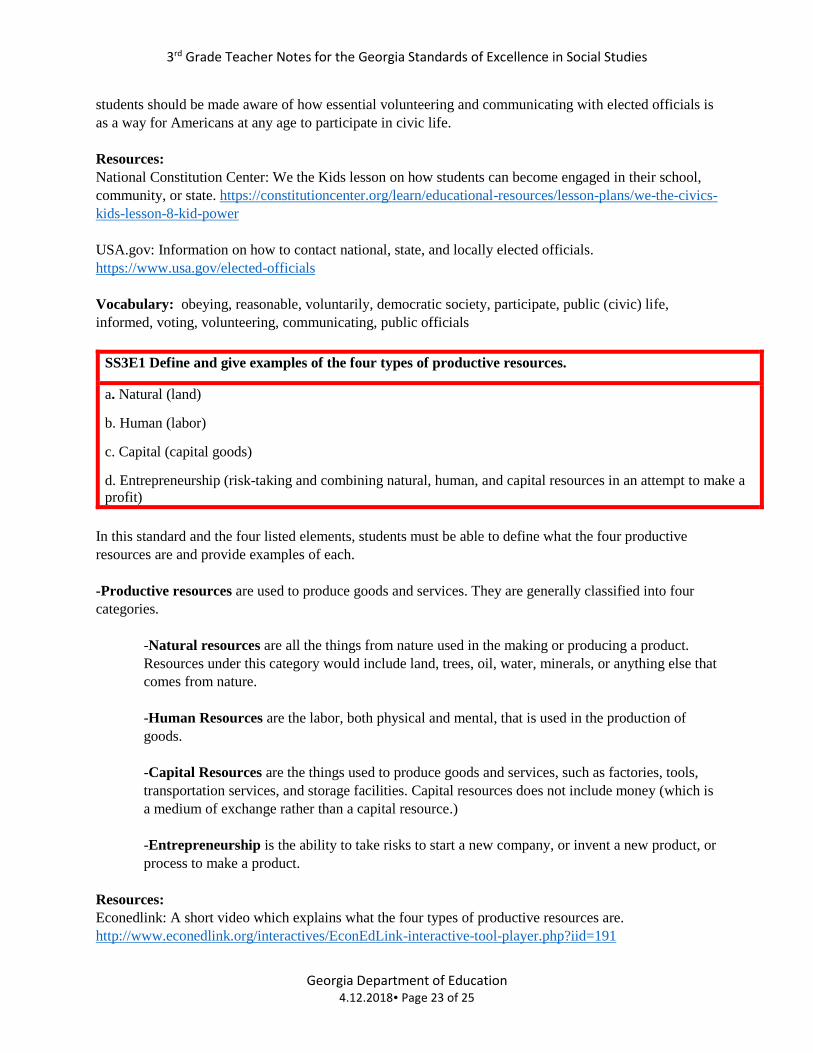
SS3E1 Define and give examples of the four types of productive resources.
a. Natural (land)
b. Human (labor)
c. Capital (capital goods)
d. Entrepreneurship (risk-taking and combining natural, human, and capital resources in an attempt to make a
profit)
In this standard and the four listed elements, students must be able to define what the four productive
resources are and provide examples of each.
-Productive resources are used to produce goods and services. They are generally classified into four
categories.
-Natural resources are all the things from nature used in the making or producing a product.
Resources under this category would include land, trees, oil, water, minerals, or anything else that
comes from nature.
-Human Resources are the labor, both physical and mental, that is used in the production of
goods.
-Capital Resources are the things used to produce goods and services, such as factories, tools,
transportation services, and storage facilities. Capital resources does not include money (which is
a medium of exchange rather than a capital resource.)
-Entrepreneurship is the ability to take risks to start a new company, or invent a new product, or
process to make a product.
Resources:
Econedlink: A short video which explains what the four types of productive resources are.
http://www.econedlink.org/interactives/EconEdLink-interactive-tool-player.php?iid=191
3rd Grade Teacher Notes for the Georgia Standards of Excellence in Social Studies
Georgia Department of Education 4.12.2018 Page 24 of 25
SS3E2 – Explain that governments provide certain types of goods and services in a market economy
(schools, libraries, roads, police/fire protection, and military) and pay for these through taxes.
For this standards, students first need to know what a market economy is: An economy where the prices
of products and services are set based on supply and demand. They also need to know that the
government provides certain services for its citizens. These can include, schools, libraries, roads,
police/fire protection, and the military. These services however, are not free. To pay for these services,
the government taxes its citizens through the things they buy or use, and through the income they earn at
their jobs.
Resources:
Investopedia: An explanation about goods and services:
http://www.investopedia.com/university/teaching-financial-literacy-kids/teaching-financial-literacy-kids-
goods-and-services.asp
Econedlink: Interactive activity on goods and services from Econedlink:
http://www.econedlink.org/tool/101/Goods-Services
Vocabulary: governments, goods, services, market economy, taxes
SS3E3 – Give examples of interdependence and trade and explain the benefits of voluntary exchange.
a. Describe the interdependence of consumers and producers.
In order for students to understand this standard, they need to know what the term interdependence
means. Simply put, it is the idea that people are dependent on others for some of their needs. People can’t
grow all the food they need to eat, or make the car they drive, or the house they live in. To get these
things people must rely on others to produce them. Trade is the idea of exchanging goods or services for
something you need or want. Money can be traded for food, a car, or a house, for example. The benefits
of voluntary exchange is that people are exchanging one thing for another which is beneficial to both
parties. If a person buys a car, the dealer is satisfied because they are gaining money for the car, and the
person buying the car is happy because they are gaining something they need or want.
Resources:
Econedlink: A lesson from Econedlink on consumers and producers which could be modified for 3rd
Grade.: http://www.econedlink.org/teacher-lesson/457/We-are-Consumers-Producers
Econedlink: Trade, Exchange and Interdependence Video from Econedlink (2:50):
http://www.econedlink.org/tool/196/Trade-Exchange-Interdependence-Video-Quiz
Vocabulary: interdependence, trade, benefits, voluntary exchange, consumers, producers
3rd Grade Teacher Notes for the Georgia Standards of Excellence in Social Studies
Georgia Department of Education 4.12.2018 Page 25 of 25
SS3E3 – Give examples of interdependence and trade and explain the benefits of voluntary exchange.
b. Describe how goods and services are allocated by price in the marketplace
For this standard students need to understand that a good is something that they can touch or hold (food, a
crayon, a video game), and a service is something another person does for someone else (a teacher, a
doctor, a mechanic all provide a service). These goods and services become part of the market place and
are allocated by what others are willing to paying for them.
Vocabulary: allocate (allocated, allocation), price, market place
SS3E3 – Give examples of interdependence and trade and explain the benefits of voluntary exchange.
c. Explain that some goods are made locally, and some elsewhere in the country, and some in other
countries.
Students need to understand that the goods and services they want and need are produced both locally,
within the United States, and elsewhere in the world. Where goods are made are dependent on the
economic resources, the wants and needs of people, and the geographic characteristics of an area (for
example, the ability to get fresh fruit from other places during the winter time). Additionally, trade
between countries also provide consumers with a greater choice of which product they want to purchase
(Think about automobiles: Imagine if there were no foreign automobiles available to consumers). The fact
that students can, and in most cases need to, purchase goods produced from all over the world, is an
example of interdependence.
Why do Nations Import: Globalization 101. Explanation on why nations import goods and services.
http://www.globalization101.org/why-do-nations-import/
Vocabulary: goods, locally, countries
SS3E4 – Explain the concept of opportunity cost as it relates to making a saving or spending choice.
Students need to explain that when they make a decision, like purchasing something, the next most
valuable thing they don’t purchase, is their opportunity cost. For example, if you go to the movies, the
money you spend is no longer available to spend on food or to save. Your opportunity cost would be the
food, or your savings.
When you choose to save, you are giving up the opportunity to purchase something you want now.
However, if you spend your money instead of saving it, you are giving up the ability to purchase more in
the future by saving up to have more money. Those next best alternatives you are giving up are your
opportunity costs.
Resources:
The Piggy Bank Primer from the St. Louis Federal Reserve- covers economic concepts such as saving,
budgeting, wants, goods, services, and opportunity cost. Can be printed from the site, or classroom sets
can be ordered for free https://www.stlouisfed.org/education/piggy-bank-primer-saving-and-budgeting
Econedlink: The Opportunity Cost of a Lifetime. Lesson which explores scarcity and opportunity cost.
http://www.econedlink.org/teacher-lesson/51/Opportunity-Cost-Lifetime
Vocabulary: opportunity cost, saving, spending, choices