Embed Size (px)
Citation preview
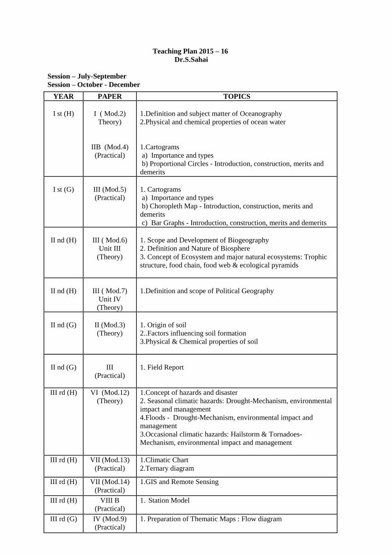
Teaching Plan 2015 – 16
Dr.S.Sahai
Session – July-September
Session – October - December
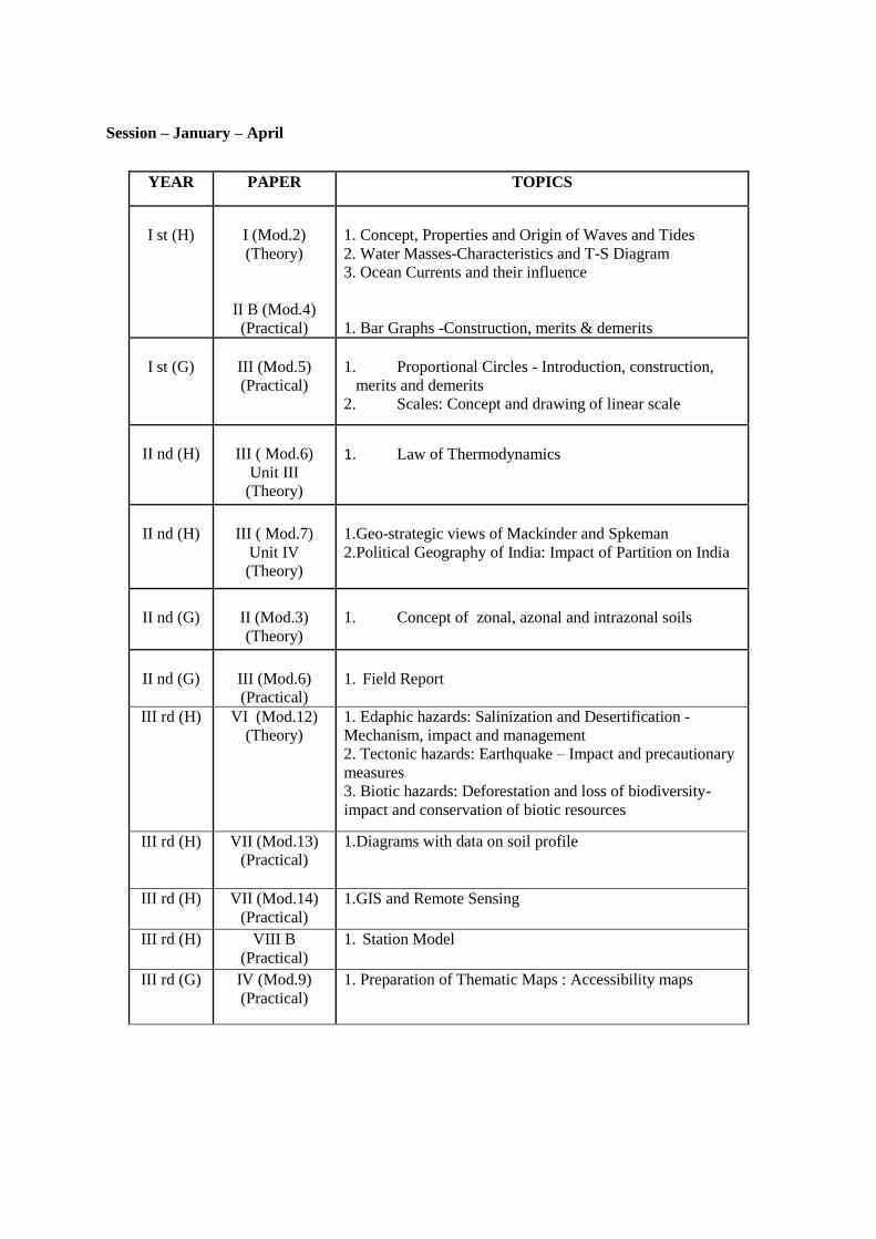
YEAR PAPER TOPICS
I st (H)
I ( Mod.2)
Theory)
IIB (Mod.4)
(Practical)
1.Definition and subject matter of Oceanography
2.Physical and chemical properties of ocean water
1.Cartograms
a) Importance and types
b) Proportional Circles - Introduction, construction, merits and
demerits
I st (G)
III (Mod.5)
(Practical)
1. Cartograms
a) Importance and types
b) Choropleth Map - Introduction, construction, merits and
demerits
c) Bar Graphs - Introduction, construction, merits and demerits
II nd (H)
III ( Mod.6)
Unit III
(Theory)
1. Scope and Development of Biogeography
2. Definition and Nature of Biosphere
3. Concept of Ecosystem and major natural ecosystems: Trophic
structure, food chain, food web & ecological pyramids
II nd (H)
III ( Mod.7)
Unit IV
(Theory)
1.Definition and scope of Political Geography
II nd (G)
II (Mod.3)
(Theory)
1. Origin of soil
2..Factors influencing soil formation
3.Physical & Chemical properties of soil
II nd (G)
III
(Practical)
1. Field Report
III rd (H) VI (Mod.12)
(Theory)
1.Concept of hazards and disaster
2. Seasonal climatic hazards: Drought-Mechanism, environmental
impact and management
4.Floods - Drought-Mechanism, environmental impact and
management
3.Occasional climatic hazards: Hailstorm & Tornadoes-
Mechanism, environmental impact and management
III rd (H) VII (Mod.13)
(Practical)
1.Climatic Chart
2.Ternary diagram
III rd (H) VII (Mod.14)
(Practical)
1.GIS and Remote Sensing
III rd (H) VIII B
(Practical)
1. Station Model
III rd (G) IV (Mod.9)
(Practical)
1. Preparation of Thematic Maps : Flow diagram
Session – January – April
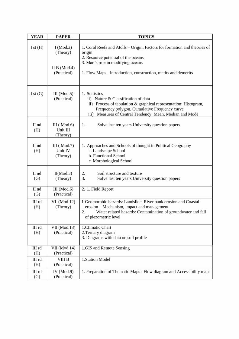
YEAR PAPER TOPICS
I st (H)
I (Mod.2)
(Theory)
II B (Mod.4)
(Practical)
II B
1. Concept, Properties and Origin of Waves and Tides
2. Water Masses-Characteristics and T-S Diagram
3. Ocean Currents and their influence
1. Bar Graphs -Construction, merits & demerits
I st (G)
III (Mod.5)
(Practical)
1. Proportional Circles - Introduction, construction,
merits and demerits
2. Scales: Concept and drawing of linear scale
II nd (H)
III ( Mod.6)
Unit III
(Theory)
1. Law of Thermodynamics
II nd (H)
III ( Mod.7)
Unit IV
(Theory)
1.Geo-strategic views of Mackinder and Spkeman
2.Political Geography of India: Impact of Partition on India
II nd (G)
II (Mod.3)
(Theory)
1. Concept of zonal, azonal and intrazonal soils
II nd (G)
III (Mod.6)
(Practical)
1. Field Report
III rd (H) VI (Mod.12)
(Theory)
1. Edaphic hazards: Salinization and Desertification -
Mechanism, impact and management
2. Tectonic hazards: Earthquake – Impact and precautionary
measures
3. Biotic hazards: Deforestation and loss of biodiversity-
impact and conservation of biotic resources
III rd (H) VII (Mod.13)
(Practical)
1.Diagrams with data on soil profile
III rd (H) VII (Mod.14)
(Practical)
1.GIS and Remote Sensing
III rd (H) VIII B
(Practical)
1. Station Model
III rd (G) IV (Mod.9)
(Practical)
1. Preparation of Thematic Maps : Accessibility maps
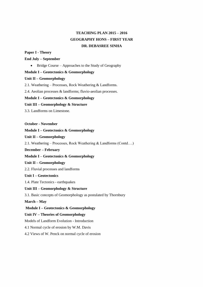
YEAR PAPER TOPICS
I st (H)
I (Mod.2)
(Theory)
II B (Mod.4)
(Practical)
1. Coral Reefs and Atolls – Origin, Factors for formation and theories of
origin
2. Resource potential of the oceans
3. Man’s role in modifying oceans
1. Flow Maps - Introduction, construction, merits and demerits
I st (G)
III (Mod.5)
(Practical)
1. Statistics
i) Nature & Classification of data
ii) Process of tabulation & graphical representation: Histogram,
Frequency polygon, Cumulative Frequency curve
iii) Measures of Central Tendency: Mean, Median and Mode
II nd
(H)
III ( Mod.6)
Unit III
(Theory)
1. Solve last ten years University question papers
II nd
(H)
III ( Mod.7)
Unit IV
(Theory)
1. Approaches and Schools of thought in Political Geography
a. Landscape School
b. Functional School
c. Morphological School
II nd
(G)
II(Mod.3)
(Theory)
2. Soil structure and texture
3. Solve last ten years University question papers
II nd
(G)
III (Mod.6)
(Practical)
2. 1. Field Report
III rd
(H)
VI (Mod.12)
(Theory)
1. Geomorphic hazards: Landslide, River bank erosion and Coastal
erosion – Mechanism, impact and management
2. Water related hazards: Contamination of groundwater and fall
of piezometric level
III rd
(H)
VII (Mod.13)
(Practical)
1.Climatic Chart
2.Ternary diagram
3. Diagrams with data on soil profile
III rd
(H)
VII (Mod.14)
(Practical)
1.GIS and Remote Sensing
III rd
(H)
VIII B
(Practical)
1.Station Model
III rd
(G)
IV (Mod.9)
(Practical)
1. Preparation of Thematic Maps : Flow diagram and Accessibility maps
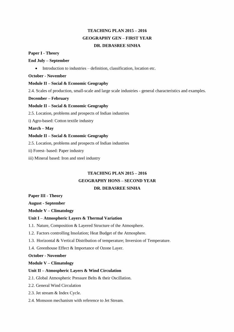
TEACHING PLAN 2015 – 2016
GEOGRAPHY HONS – FIRST YEAR
DR. DEBASREE SINHA
Paper I - Theory
End July – September
Bridge Course – Approaches to the Study of Geography
Module I – Geotectonics & Geomorphology
Unit II – Geomorphology
2.1. Weathering – Processes, Rock Weathering & Landforms.
2.4. Aeolian processes & landforms; fluvio-aeolian processes.
Module I – Geotectonics & Geomorphology
Unit III – Geomorphology & Structure
3.3. Landforms on Limestone.
October - November
Module I – Geotectonics & Geomorphology
Unit II – Geomorphology
2.1. Weathering – Processes, Rock Weathering & Landforms (Contd….)
December – February
Module I – Geotectonics & Geomorphology
Unit II – Geomorphology
2.2. Fluvial processes and landforms
Unit I – Geotectonics
1.4. Plate Tectonics - earthquakes
Unit III – Geomorphology & Structure
3.1. Basic concepts of Geomorphology as postulated by Thornbury
March – May
Module I – Geotectonics & Geomorphology
Unit IV – Theories of Geomorphology
Models of Landform Evolution - Introduction
4.1 Normal cycle of erosion by W.M. Davis
4.2 Views of W. Penck on normal cycle of erosion
TEACHING PLAN 2015 – 2016
GEOGRAPHY GEN – FIRST YEAR
DR. DEBASREE SINHA
Paper I - Theory
End July – September
Introduction to industries – definition, classification, location etc.
October - November
Module II – Social & Economic Geography
2.4. Scales of production, small-scale and large scale industries - general characteristics and examples.
December – February
Module II – Social & Economic Geography
2.5. Location, problems and prospects of Indian industries
i) Agro-based: Cotton textile industry
March – May
Module II – Social & Economic Geography
2.5. Location, problems and prospects of Indian industries
ii) Forest- based: Paper industry
iii) Mineral based: Iron and steel industry
TEACHING PLAN 2015 – 2016
GEOGRAPHY HONS – SECOND YEAR
DR. DEBASREE SINHA
Paper III - Theory
August - September
Module V – Climatology
Unit I – Atmospheric Layers & Thermal Variation
1.1. Nature, Composition & Layered Structure of the Atmosphere.
1.2. Factors controlling Insolation; Heat Budget of the Atmosphere.
1.3. Horizontal & Vertical Distribution of temperature; Inversion of Temperature.
1.4. Greenhouse Effect & Importance of Ozone Layer.
October - November
Module V – Climatology
Unit II – Atmospheric Layers & Wind Circulation
2.1. Global Atmospheric Pressure Belts & their Oscillation.
2.2. General Wind Circulation
2.3. Jet stream & Index Cycle.
2.4. Monsoon mechanism with reference to Jet Stream.
December – March
Module V – Climatology
Unit III – Precipitation & Airmass
3.1. Processes & Forms of Condensation.
3.2. Mechanism & Forms of Precipitation – Ice Crystal Theory, Collision-coalescence Theory. .
3.3. Airmass: Typology, origin & characteristics.
3.4. Warm & Cold Fronts; Frontogenesis & Frontolysis.
Unit IV – Weather Disturbance & Climatic Classification
4.1. Tropical Cyclone.
4.2. Mid-latitude Cyclone & Anticyclone.
4.3. Climatic Classification after Koppen.
4.4. Climatic Classification after Thornthwaite: 1931 & 1948.
TEACHING PLAN 2015 – 2016
GEOGRAPHY GEN – SECOND YEAR
DR. DEBASREE SINHA
Paper II – Theory
August - September
Module III - Climatology, Soil and Biogeography
3.6 Definition of ecosystem and Biomes; Tropical rainforest; Savannah; Hot desert
3.7 Plant types and distribution (halophyte, xerophytes, hydrophytes and mesophytes); animal
communities
October - November
Module III - Climatology, Soil and Biogeography
3.3 Climatic classification after Koppen
December – March
3.1 Insolation and Heat Budget
3.1 Horizontal and vertical distribution of temperature and pressure; Greenhouse effect
3.2 Monsoon system: its origin and mechanism; Tropical disturbances: thunderstorm and cyclone
Paper III – Practical
August – September
Module VI – Applied Geographical Techniques II
6.1 Map projections: Concept and classification; Polar Zenithal Stereographic Projection.
October - November
6.1 Simple Conic with One standard Parallel, Cylindrical Equal Area Projections
December – March
Module V - Applied Geographical Techniques - I
Revision of Scale and Statistics.
TEACHING PLAN 2015 – 2016
GEOGRAPHY HONS – THIRD YEAR
DR. DEBASREE SINHA
Paper VIII A – Practical
End July – September
Module XV – Statistical Techniques
Unit I – Basic Concepts
1.1. Significance of Statistical Techniques in Geography, nature of Statistical Data: Discrete,
Continuous, Parametric & non-Parametric.
1.2. Sampling Techniques: Random, Stratified random & Purposive.
1.3. Frequency Distribution: Histogram, Frequency Polygon, Ogive, Normal & Skewed Distribution.
1.4. Measures of Central Tendency: Mean, Median, Mode, Partition Values – Quartile, Decile &
Percentile.
Unit II – Dispersion & Regression
2.1. Measures of Dispersion: Mean Deviation, Quartile Deviation, Standard Deviation & Coefficient
of Variation.
October - November
Module XV – Statistical Techniques
Unit II – Dispersion & Regression
2.2. Bivariate Scatter Diagram & Regression Trend line.
2.3. Coefficient of Correlation after Karl Pearson.
December – February
Module XV – Statistical Techniques
Unit II – Dispersion & Regression
2.4. Time Series Analysis: Moving Average, Semi-average, Least Square Method.
Practice & Solution of Question Papers.
Completion of Practical File.
TEACHING PLAN 2015 – 2016
GEOGRAPHY GEN – THIRD YEAR
DR. DEBASREE SINHA
Paper IV A - Theory
End July – September
Module VII – Land Use & Settlement Geography
7.5. Concept and attributes of land.
7.6. Objectives and principles of land use.
7.7. Factors influencing land use and land categories
iii) Agricultural land use.
iv) Non-agricultural land use.
October - November
Module IX - Applied Geographical Techniques – III
9.1 Preparation of land use maps from cadastral maps based on primary or secondary data
December – February
Module VII – Land Use & Settlement Geography
7.8 Rural and urban settlements:
iii) Rural settlements: evolution, nature and characteristics, effect of physical environment;
iv) Urban settlements: definition, morphology and functions.
TEACHING PLANS 2015-16
Kaustuva Banerjee
(FIRST YEAR HONOURS)
SESSION: July to September:
Bridge course:Models.Definition, Scope and content of Hydrology. Global Hydrological Cycle; its
physical and biological role. Drainage basin as a hydrological unit. Run off
SESSION: October to December:
Run off cycle,Physical and chemical properties of ground water.Components, factors and processes
controlling storage and movement of ground water.
SESSION: JANUARY to MARCH:
Ground water movement and storage. Types of aquifers.
(FIRST YEAR GENERAL)
SESSION: July to September
Growth and distribution of world population; Migration: types, causes and consequences.
Sectors of Economy-primary, secondary, tertiary and quaternary. It’s changing emphasis through
time.
SESSION: October to December
Contemporary social issues; literacy, poverty and gender issues.
Forms of Economy-hunting, gathering and shifting cultivation of India
SESSION: January to March
Traditional economies-Intensive subsistence rice farming in India.
Modern economies-Commercial grain farming and Mixed farming
(SECOND YEAR HONOURS)
SESSION: July to September
Closed traverse survey by Prismatic Compass.
Preparation of Level Book.
Biogeochemical cycles
SESSION: October to December
Contouring by leveling along radial line by a Dumpy Level: at least three radial lines
to be set out from a common centre and their relative position to be obtained by
measurement of magnetic bearing and/or included angle by Prismatic Compass
Biomes
SESSION: JANUARY to MARCH
Longitudinal /profile leveling by Dumpy Level
Significance of biodiversity conservation
(SECOND YEAR GENERAL)
SESSION: July to September
Vagaries of monsoon
SESSION: October to December
Soil erosion and conservation
SESSION: JANUARY to MARCH
Revision
(THIRD YEAR HONOURS) SESSION: July to September
Ombrothermic chart, river bank erosion, climatic regions
GIS – Georeferencing and digitization.
SESSION: October to December
Rainfall Dispersion Diagram, drought and flood mapping, Edaphic and agricultural regions,
Preparation of cartograms and thematic maps.
SESSION: January to March
Biogeographic regions,Revision of gis through 21st Century software
Teaching Plan 2015-2016
For 1st Year
Geography Mrs S. Ganguly
Session : July - September
Bridge course : System analysis in geography
Session October - December
Module 1 GEOTECTONICS AND GEOMORPHOLOGY (Th.) 50 Marks
Unit I: Geotectonics
1.1 Origin of the Earth with particular reference to Big Bang Theory; Geological time scale and
related topographic and structural evolution (03)
1.2 Isostasy: Airy and Pratt (02)
1.3 Folds and Faults—origin, types and their topographic expressions (03)
Geography Mrs S. Ganguly
Teaching Plan 2015-2016 For 1st Yr Practical
Session July – December And Also From January -March Module 4 Cartograms and Geological Maps (Pr.) 50 Marks
1.3 Interpretation of Geological maps (16 marks)
a) Study of Horizontal, Vertical and tilted beds along with alignment of contours:
Study of strike, dip and bedding plane
b) Drawing of sections on uniclinal and simple folded structures depicting unconformity, succession
of beds and their thickness
c) Interpretation of the section covering geological history and relation between topography and
structure
Session july – december and also from January -march
Module 4 Cartograms and Geological Maps (Pr.) 50 Marks
1.3 Interpretation of Geological maps (16 marks)
a) Study of Horizontal, Vertical and tilted beds along with alignment of contours:
Study of strike, dip and bedding plane
b) Drawing of sections on uniclinal and simple folded structures depicting unconformity, succession
of beds and their thickness
Teaching Plan 2015-2016
For 2nd Year Honours
Geography Mrs S.Ganguly
Session : July – September
PART II Module 5 Climatology (Th.) 50 Marks
Unit I: Atmospheric Layers and Thermal Variation
1.1 Nature, composition and layered structure of the atmosphere (02)
1.2 Factors controlling insolation ; heat budget of the atmosphere (03)
1.3 Horizontal and vertical distribution of temperature; Inversion of temperature(02)
1.4 Green house effect and importance of ozone layer (04)
Session October - December
Unit II: Atmospheric Layers and Wind Circulation
2.1 Global atmospheric pressure belts and their oscillation (02)
2.2 General wind circulation
2.3 Jet stream and index cycle (04)
2.4 Monsoon mechanism with reference to jet stream (04)
Session January - March
Unit III: Precipitation and Air mass
3.1 Processes and forms of condensation (02)
3.2 Mechanism and forms of precipitation- Ice Crystal theory, Collision-coalescence Theory (04)
3.3 Airmass: typology, origin and characteristics (03)
3.4 Warm and cold fronts; frontogenesis and frontolysis (04)
Unit IV: Weather Disturbance and Climatic Classification
4.1 Tropical cyclone (03)
4.2 Mid-latitude cyclone and anti-cyclone (03)
4.3 Climatic classification after Koppen and Thornthwaite
Teaching Plan 2015-2016
For 2nd Year General
Geography Mrs S.Ganguly
Session : July – September
Definition of ecosystem and Biomes
; Tropical rainforest; Savannah; Hot desert;
4.7 Plant types and distribution (halophyte, xerophytes, hydrophytes and mesophyte); animal
communities
Session : July – September
2.3 Sectors of economy: primary, secondary tertiary and quaternary: Changing emphasis through time
; Forms of economy i) Tribal economies: hunting, gathering, shifting cultivation of India.
Teaching Plan 2015-2016
For 3rd Year Honours
Geography Mrs S.Ganguly
Session : July – September
Population and Settlement Geography (Th.) 50 Marks
Unit I: Population Dynamics and Settlement Geography
2) Unit III: Rural Settlements 3.1 Definition, nature and characteristics of rural settlements (02) 3.2
Morphology of rural settlements: site and situation, layout-internal and external (04) 3.3 Rural house
types with reference to India (03)
3.4 Social segregation in rural areas; Census categories of rural settlements (03)
Unit IV: Urban Settlements
4.1 Census definition and categories in India (02)
4.2 Urban morphology: Classical models-Burgess, Homer Hoyt, Harris and Ullman (04)
4.3 Metropolitan concept, City-region and Conurbation (03)
4.4 Functional classification of cities: Harris, Nelson and McKenzie (04)
Session – January - March
Unit IV: Studies of Geographical Problem
s 4.1 Problems of unreliability of rainfall (03)
4.4 Problems of slum and urban rehabilitation in India
Unit III: Case Studies
3.1 Meghalaya Plateau as Physiographic Region (03)
3.2 Damodar Valley as Planning Region (03)
3.3 Western Rajasthan as Arid Region (03)
3.4 Sundarbans as Biotic Region
Teaching Plan 2015-2016
For 3rd Year General
Mrs S.Ganguly
Session : July – September
`Remote Sensing and thematic mapping
8.1 Definition of remote sensing , different methods of remote sensing ,air photo and satellite imagery
8.2 Air photo: Charecteristics and interpretation
8.3 Satelllite imagery : types and characteristic of IRS Imageries0
Session –January - March
Practice the imageries and their interpretation.
Teaching Plan of First Year Honours 2015-16
(Mrs S. Ray Kumam)
Paper II A Module 3
July -Sept.
1. Unit I---1.1Concept of and classification of resources Economic and Environmental approaches.,
1.2, 1,4 (distribution and production of mineral resources)
2. Unit II—2.1, 2.3(Intensive agriculture-rice, Extensive agriculture- wheat)
Nov-Dec
1. Unit II---2.3 (Plantation farming and tea, Mixed farming in NW Europe)
2. Unit II----2.2 (Forestry)
Jan-May
0. Unit II---2.2 (Fishing, Livestock farming), 2.4
1. Unit I---- 1.3 Land as resource and Problems of land acquisition in developing countries,
EPZ,SEZ Land reforms with special reference to West Bengal, 1.4 (global scenario related to
problems and management)
2. Unit II---2.4 Land use and agricultural models:Stamp, von Thunen and Weaver
Teaching Plan Of Second Year Honours 2015-16
(Mrs S. Ray Kumam)
Paper IV A
Module 7
Aug -Oct
1. Unit III 3.1 Concept of Culture in Geography definition, scope, concept of Cultural Geography
2. Unit III 3.3 Cultural regions,cultural areas, cultural landscape
Nov- Dec.
1. Unit III 3.4 Cultural assimilation, integration and diffusion
Jan-March
1. Unit III 3.2 Cultural Groups (India)ethnic, linguistic, religious
Paper IV B
Module 8
Aug – Oct Morphometric techniques
Relative relief, Average slope, drainage density road density
Drawing and analysis of profiles and transect chart
Nov- Dec Analysis of landforms and drawing of physiographic regions and other
Maps
Jan- Mar Interpretation
Teaching Plan Of Third Year Honours 2015-16
(Mrs S. Ray Kumam)
Paper V
Aug- Oct
Module9 Unit I
1. Factors influencing spatial distribution and density of population
2. Population growth: global trends and patterns
Unit II
2.1 Determinants and Measures of Fertility, Mortality
Nov-Dec
Unit II
1. 2.1.Mortality, Migration
2. 2.2. Theories of Population : Malthus Marx
3. 2.3.Demographic Transition
Unit I
3. Population Structure
4. Population Composition
Jan –Feb
2.4 Population Resource Region
Module 10 Unit II
July-September
2.1 Structure and Physiography
2.4Agricultural Regions
October- December
2.2 Drainage
2.3 Climatic Edaphic Biotic regions
Paper VI
Module 12
Contemporary Issues
Aug-Oct
1. Meaning of development, basic indicators of economic development
2. Poverty and inequality, unemployment, dependency ratio, work participation ,poverty
alleviation
Nov -Dec
3. Food Security and Hunger, Population growth, malnutrition, morbidity and
mortality
4. Globalization
Jan-Feb
5. Sustainable Development
Paper VII
Module 13
July-September
3.1 Climatic Chart
October-December
3.3 Diagrams with data on soil profile
Jan- Feb
3.2 Ternary Diagram
Teaching Plan Of First Year General 2015-16
(Mrs S. Ray Kumam)
Module 1
July -September
Fluvial Processes Eolian Processes
October- December
Glacial Processes
Jan-May
Coastal Processes, Cycles of Erosion
Paper III
Scales
Teaching Plan Of Second Year General 2015-16
( Mrs S. Ray Kumam)
1.2 Broad Physiographic regions of India- Western Himalayas
1.3 Vagaries of Indian Monsoon and its impact
Problems of floods and droughts.
Paper III
August- September
Cartograms
October- December
Map Projections
January- March
Revision of Practicals
Teaching Plan Of Third Year General 2015-16
( Mrs S. Ray Kumam)
Module VII
July- September 1.1 Concept and Attributes of Land
1.2 Objectives and Principles of Landus 1.3 Factors influencing lands and land
cate a) Agricultural land use b) Non- agricultural land use
MrsSethwala
TEACHING PLAN 2015-16
IIIrd Year Honours
July to September
Module 13 Unit I Map Projections, concept , classification and properties.. Zenithal
Stereographic Projection, Simple Conical projection ,
Lorenz Curve
Module 10 Unit IV Problems of Development of SEZ in India
October to December
Module 13 Unit I Bonnes projection, Sinusoidal projection , Polyconic projection
Location Quotient
Module 10 Unit IV Problems of slum and Urban rehabilitation in India
January toFebruary
Module 13 Unit I Cylindrical projection and Mercators Projection
Mrs Sethwala
TEACHING PLAN 2015-16
II Year Honours
August to September
Module 7 Unit I Definition of Social Geography, Scope and content.
Evolution of Social Geography: Approaches
Project work
October to December
Module7 Unit I Approaches contd. Possibilistic, Behavioural, Radical, and
Welfare
January to April
Module 7 Unit I Social structure, social processes, social patterns.
Approches continued
Discussion of Question Papers