Embed Size (px)
Citation preview
wingtra.com
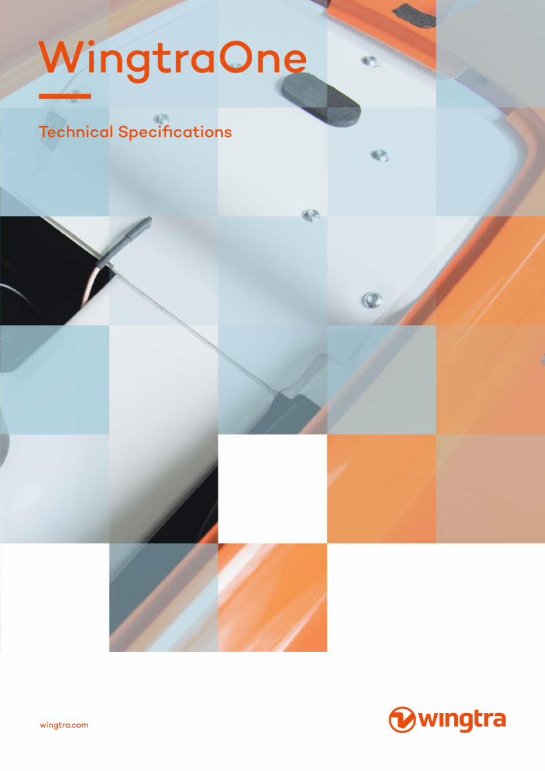
WingtraOneTechnical Specifications
01Technical Specifications WingtraOne 1
02 Technical Specifiications Payloads 8
CONTENT
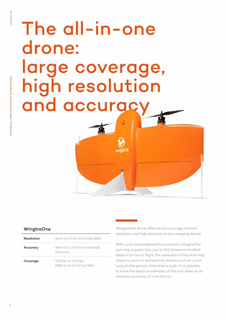
The all-in-one drone: large coverage, high resolution and accuracy
WingtraOne drone offers broad coverage, brilliant
resolution and high accuracy in one mapping device.
With such unprecedented functionality, WingtraOne
can map a quarry the size of 240 American football
fields in an hour‘s flight. The resolution of the final map
allows to zoom in and see tiny details such as a coin
lying on the ground. And what is best—it is possible
to know the exact coordinates of the coin down to an
absolute accuracy of 1 cm (0.4 in).
WingtraOne
Resolution down to 0.7 cm (0.3 in)/px GSD
Accuracy down to 1 cm (0.4 in) absolute accuracy
Coverage 400 ha at 3 cm/px (988 ac at 1.2 in/ px) GSD
1
0
1T
EC
HN
ICA
L S
PE
CIF
ICA
TIO
NS
WIN
GT
RA
ON
E
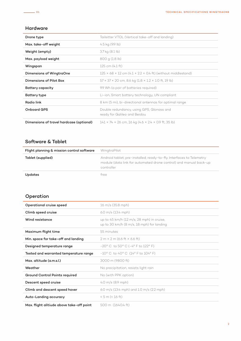
Hardware
Drone type Tailsitter VTOL (Vertical take-off and landing)
Max. take-off weight 4.5 kg (9.9 lb)
Weight (empty) 3.7 kg (8.1 lb)
Max. payload weight 800 g (1.8 lb)
Wingspan 125 cm (4.1 ft)
Dimensions of WingtraOne 125 × 68 × 12 cm (4.1 × 2.2 × 0.4 ft) (without middlestand)
Dimensions of Pilot Box 57 × 37 × 20 cm, 8.6 kg (1.8 × 1.2 × 1.0 ft, 19 lb)
Battery capacity 99 Wh (a pair of batteries required)
Battery type Li-ion, Smart battery technology, UN compliant
Radio link 8 km (5 mi), bi-directional antennas for optimal range
Onboard GPS Double redundancy, using GPS, Glonass and ready for Galileo and Beidou
Dimensions of travel hardcase (optional) 141 × 74 × 26 cm, 16 kg (4.6 × 2.4 × 0.9 ft, 35 lb)
Software & Tablet
Flight planning & mission control software WingtraPilot
Tablet (supplied) Android tablet; pre-installed; ready-to-fly. Interfaces to Telemetry module (data link for automated drone control) and manual back-up controller
Updates free
Operation
Operational cruise speed 16 m/s (35.8 mph)
Climb speed cruise 6.0 m/s (13.4 mph)
Wind resistance up to 45 km/h (12 m/s, 28 mph) in cruise, up to 30 km/h (8 m/s, 18 mph) for landing
Maximum flight time 55 minutes
Min. space for take-off and landing 2 m × 2 m (6.6 ft × 6.6 ft)
Designed temperature range -20° C to 50° C (-4° F to 122° F)
Tested and warranted temperature range -10° C to 40° C (14° F to 104° F)
Max. altitude (a.m.s.l.) 3000 m (9800 ft)
Weather No precipitation, resists light rain
Ground Control Points required No (with PPK option)
Descent speed cruise 4.0 m/s (8.9 mph)
Climb and descent speed hover 6.0 m/s (13.4 mph) and 1.0 m/s (2.2 mph)
Auto-Landing accuracy < 5 m (< 16 ft)
Max. flight alitiude above take-off point 500 m (1640.4 ft)
2
01 TECHNICAL SPECIF ICATIONS WINGTRAONE
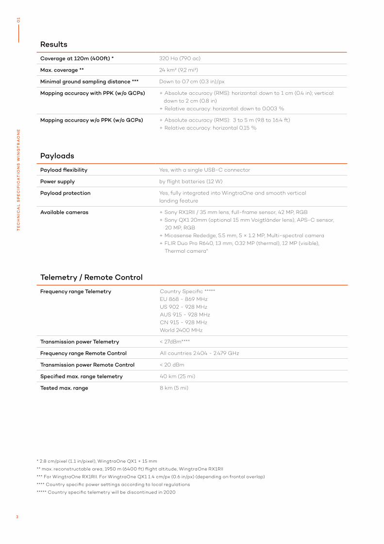
* 2.8 cm/pixel (1.1 in/pixel), WingtraOne QX1 + 15 mm
** max. reconstructable area, 1950 m (6400 ft) flight altitude, WingtraOne RX1RII
*** For WingtraOne RX1RII. For WingtraOne QX1 1.4 cm/px (0.6 in/px) (depending on frontal overlap)
**** Country specific power settings according to local regulations
***** Country specific telemetry will be discontinued in 2020
Results
Coverage at 120m (400ft) * 320 Ha (790 ac)
Max. coverage ** 24 km² (9,2 mi²)
Minimal ground sampling distance *** Down to 0.7 cm (0.3 in)/px
Mapping accuracy with PPK (w/o GCPs) + Absolute accuracy (RMS): horizontal: down to 1 cm (0.4 in); vertical: down to 2 cm (0.8 in)+ Relative accuracy: horizontal: down to 0.003 %
Mapping accuracy w/o PPK (w/o GCPs) + Absolute accuracy (RMS): 3 to 5 m (9.8 to 16.4 ft)+ Relative accuracy: horizontal 0.15 %
Telemetry / Remote Control
Frequency range Telemetry Country Specific *****EU 868 - 869 MHzUS 902 - 928 MHzAUS 915 - 928 MHzCN 915 - 928 MHzWorld 2400 MHz
Transmission power Telemetry < 27dBm****
Frequency range Remote Control All countries 2.404 - 2.479 GHz
Transmission power Remote Control < 20 dBm
Specified max. range telemetry 40 km (25 mi)
Tested max. range 8 km (5 mi)
Payloads
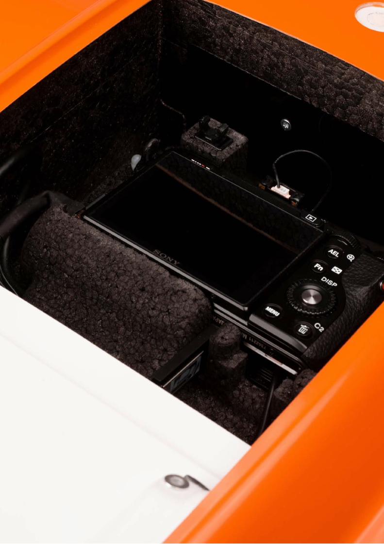
Payload flexibility Yes, with a single USB-C connector
Power supply by flight batteries (12 W)
Payload protection Yes, fully integrated into WingtraOne and smooth vertical landing feature
Available cameras + Sony RX1RII / 35 mm lens, full-frame sensor, 42 MP, RGB+ Sony QX1 20mm (optional 15 mm Voigtländer lens), APS-C sensor, 20 MP, RGB+ Micasense Rededge, 5.5 mm, 5 × 1.2 MP, Multi-spectral camera + FLIR Duo Pro R640, 13 mm, 0.32 MP (thermal), 12 MP (visible), Thermal camera"
0
1T
EC
HN
ICA
L S
PE
CIF
ICA
TIO
NS
WIN
GT
RA
ON
E
3
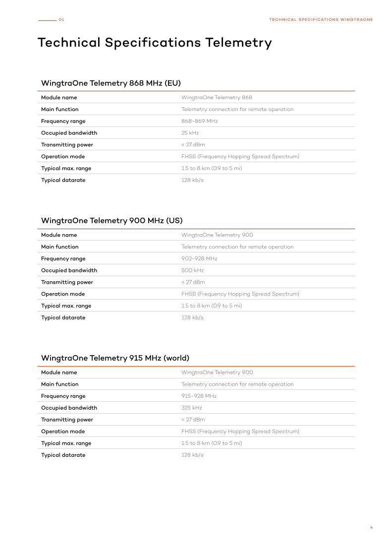
WingtraOne Telemetry 900 MHz (US)
Module name WingtraOne Telemetry 900
Main function Telemetry connection for remote operation
Frequency range 902-928 MHz
Occupied bandwidth 500 kHz
Transmitting power < 27 dBm
Operation mode FHSS (Frequency Hopping Spread Spectrum)
Typical max. range 1.5 to 8 km (0.9 to 5 mi)
Typical datarate 128 kb/s
WingtraOne Telemetry 868 MHz (EU)
Module name WingtraOne Telemetry 868
Main function Telemetry connection for remote operation
Frequency range 868-869 MHz
Occupied bandwidth 25 kHz
Transmitting power < 27 dBm
Operation mode FHSS (Frequency Hopping Spread Spectrum)
Typical max. range 1.5 to 8 km (0.9 to 5 mi)
Typical datarate 128 kb/s
Technical Specifications Telemetry
WingtraOne Telemetry 915 MHz (world)
Module name WingtraOne Telemetry 900
Main function Telemetry connection for remote operation
Frequency range 915-928 MHz
Occupied bandwidth 325 kHz
Transmitting power < 27 dBm
Operation mode FHSS (Frequency Hopping Spread Spectrum)
Typical max. range 1.5 to 8 km (0.9 to 5 mi)
Typical datarate 128 kb/s
4
01 TECHNICAL SPECIF ICATIONS WINGTRAONE
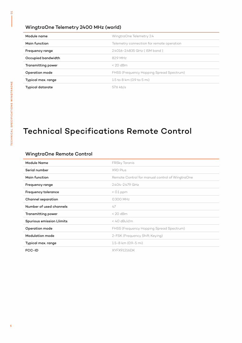
WingtraOne Telemetry 2400 MHz (world)
Module name WingtraOne Telemetry 2.4
Main function Telemetry connection for remote operation
Frequency range 2.4016-2.4835 GHz ( ISM band )
Occupied bandwidth 82.9 MHz
Transmitting power < 20 dBm
Operation mode FHSS (Frequency Hopping Spread Spectrum)
Typical max. range 1.5 to 8 km (0.9 to 5 mi)
Typical datarate 57.6 kb/s
WingtraOne Remote Control
Module Name FRSky Taranis
Serial number X9D Plus
Main function Remote Control for manual control of WingtraOne
Frequency range 2.404-2.479 GHz
Frequency tolerance < 0.1 ppm
Channel separation 0.300 MHz
Number of used channels 47
Transmitting power < 20 dBm
Spurious emission Llimits < 40 dBuV/m
Operation mode FHSS (Frequency Hopping Spread Spectrum)
Modulation mode 2-FSK (Frequency Shift Keying)
Typical max. range 1.5-8 km (0.9-5 mi)
FCC-ID XYFX91216DK
Technical Specifications Remote Control
5
0
1T
EC
HN
ICA
L S
PE
CIF
ICA
TIO
NS
WIN
GT
RA
ON
E
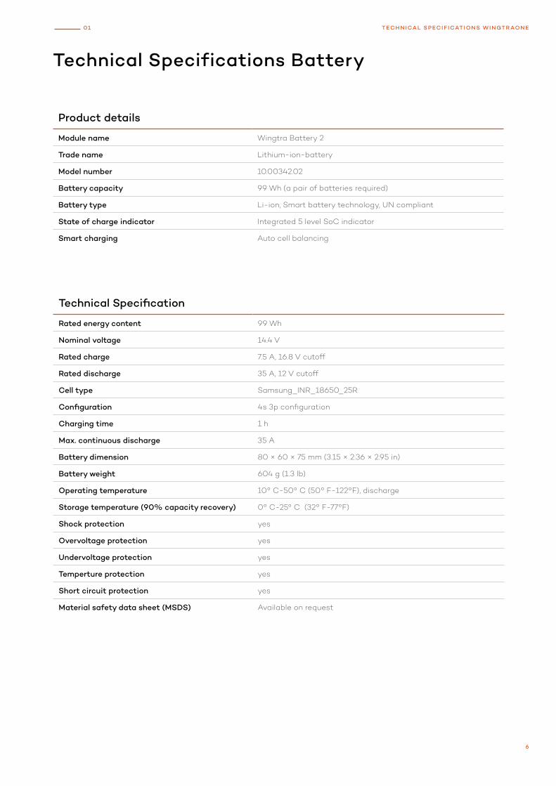
Product details
Module name Wingtra Battery 2
Trade name Lithium-ion-battery
Model number 10.00342.02
Battery capacity 99 Wh (a pair of batteries required)
Battery type Li-ion, Smart battery technology, UN compliant
State of charge indicator Integrated 5 level SoC indicator
Smart charging Auto cell balancing
Technical Specification
Rated energy content 99 Wh
Nominal voltage 14.4 V
Rated charge 7.5 A, 16.8 V cutoff
Rated discharge 35 A, 12 V cutoff
Cell type Samsung_INR_18650_25R
Configuration 4s 3p configuration
Charging time 1 h
Max. continuous discharge 35 A
Battery dimension 80 × 60 × 75 mm (3.15 × 2.36 × 2.95 in)
Battery weight 604 g (1.3 lb)
Operating temperature 10° C-50° C (50° F-122°F), discharge
Storage temperature (90% capacity recovery) 0° C-25° C (32° F-77°F)
Shock protection yes
Overvoltage protection yes
Undervoltage protection yes
Temperture protection yes
Short circuit protection yes
Material safety data sheet (MSDS) Available on request
Technical Specifications Battery
6
01 TECHNICAL SPECIF ICATIONS WINGTRAONE
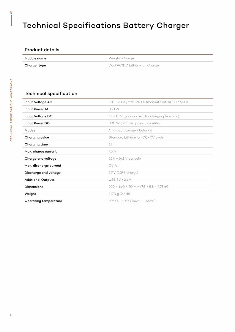
Product details
Module name Wingtra Charger
Charger type Dual AC/DC Lithium Ion Charger
Technical Specifications Battery Charger
Technical specification
Input Voltage AC 110-120 V / 220-240 V (manual switch), 50 / 60Hz
Input Power AC 350 W
Input Voltage DC 11 - 18 V (optional, e.g. for charging from car)
Input Power DC 300 W (reduced power possible)
Modes Charge / Storage / Balance
Charging cylce Standard Lithium Ion CC-CV cycle
Charging time 1 h
Max. charge current 7.5 A
Charge end voltage 16.4 V (4.1 V per cell)
Max. discharge current 0.6 A
Discharge end voltage 3.7 V (30% charge)
Addtional Outputs USB 5V / 2.1 A
Dimensions 190 × 140 × 70 mm (7.5 × 5.5 × 2.75 in)
Weight 1170 g (2.6 lb)
Operating temperature 10° C - 50° C (50° F - 122°F)
7
0
1T
EC
HN
ICA
L S
PE
CIF
ICA
TIO
NS
WIN
GT
RA
ON
E
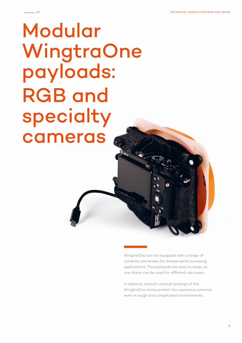
Modular WingtraOne payloads: RGB and specialty cameras
WingtraOne can be equipped with a range of
cameras and lenses for diverse aerial surveying
applications. The payloads are easy to swap, so
one drone can be used for different use cases.
In addition, smooth vertical landings of the
WingtraOne drone protect the expensive cameras
even in rough and complicated environments.
8
02 TECHNICAL SPECIF I ICATIONS PAYLOADS
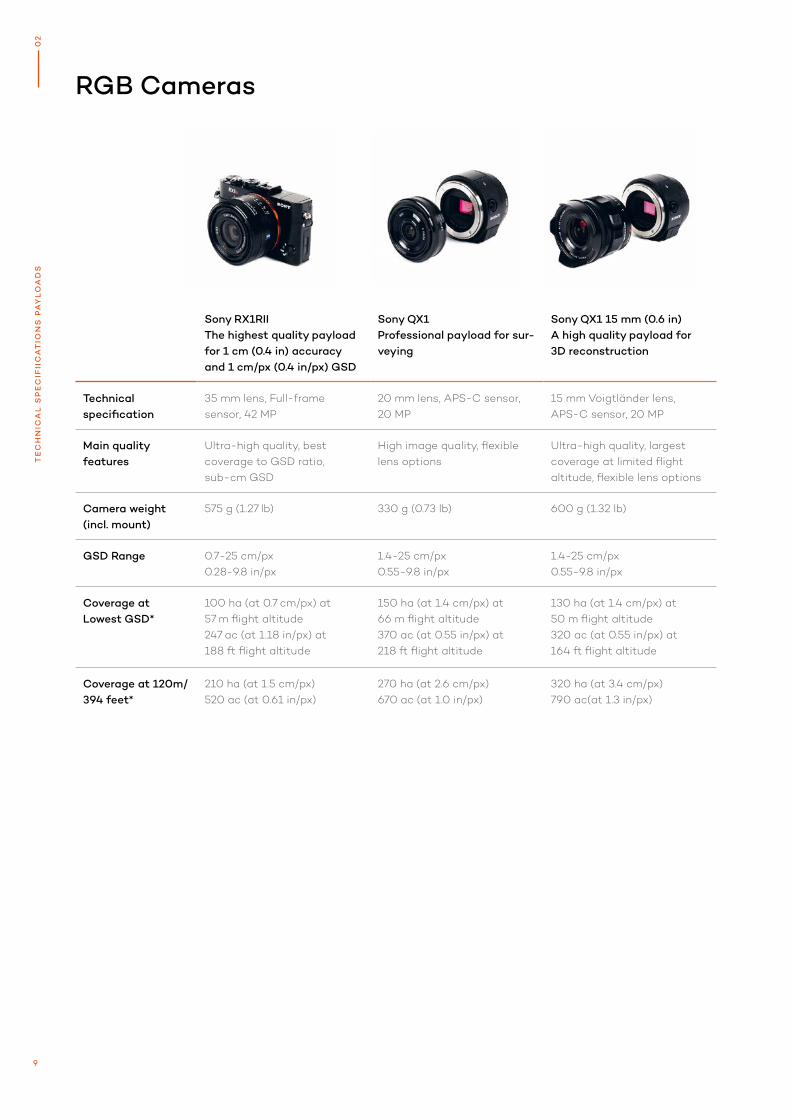
RGB Cameras
Sony RX1RIIThe highest quality payload for 1 cm (0.4 in) accuracy and 1 cm/px (0.4 in/px) GSD
Sony QX1Professional payload for sur-veying
Sony QX1 15 mm (0.6 in) A high quality payload for 3D reconstruction
Technical specification
35 mm lens, Full-frame sensor, 42 MP
20 mm lens, APS-C sensor, 20 MP
15 mm Voigtländer lens, APS-C sensor, 20 MP
Main quality features
Ultra-high quality, best coverage to GSD ratio, sub-cm GSD
High image quality, flexible lens options
Ultra-high quality, largest coverage at limited flight altitude, flexible lens options
Camera weight(incl. mount)
575 g (1.27 lb) 330 g (0.73 lb) 600 g (1.32 lb)
GSD Range 0.7-25 cm/px0.28-9.8 in/px
1.4-25 cm/px0.55-9.8 in/px
1.4-25 cm/px0.55-9.8 in/px
Coverage atLowest GSD*
100 ha (at 0.7 cm/px) at 57 m flight altitude247 ac (at 1.18 in/px) at 188 ft flight altitude
150 ha (at 1.4 cm/px) at 66 m flight altitude370 ac (at 0.55 in/px) at 218 ft flight altitude
130 ha (at 1.4 cm/px) at 50 m flight altitude320 ac (at 0.55 in/px) at 164 ft flight altitude
Coverage at 120m/ 394 feet*
210 ha (at 1.5 cm/px)520 ac (at 0.61 in/px)
270 ha (at 2.6 cm/px)670 ac (at 1.0 in/px)
320 ha (at 3.4 cm/px)790 ac(at 1.3 in/px)
9
02
TE
CH
NIC
AL
SP
EC
IFII
CA
TIO
NS
PA
YL
OA
DS
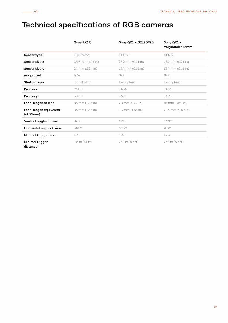
Technical specifications of RGB cameras
Sony RX1RII Sony QX1 + SEL20F28 Sony QX1 + Voigtländer 15mm
Sensor type Full Frame APS-C APS-C
Sensor size x 35.9 mm (1.41 in) 23.2 mm (0.91 in) 23.2 mm (0.91 in)
Sensor size y 24 mm (0.94 in) 15.4 mm (0.61 in) 15.4 mm (0.61 in)
mega pixel 42.4 19.8 19.8
Shutter type leaf shutter focal plane focal plane
Pixel in x 8000 5456 5456
Pixel in y 5320 3632 3632
Focal length of lens 35 mm (1.38 in) 20 mm (0.79 in) 15 mm (0.59 in)
Focal length equivalent (at 35mm)
35 mm (1.38 in) 30 mm (1.18 in) 22.6 mm (0.89 in)
Veritcal angle of view 37.8° 42.1° 54.3°
Horizontal angle of view 54.3° 60.2° 75.4°
Minimal trigger time 0.6 s 1.7 s 1.7 s
Minimal trigger distance
9.6 m (31 ft) 27.2 m (89 ft) 27.2 m (89 ft)
10
02 TECHNICAL SPECIF I ICATIONS PAYLOADS
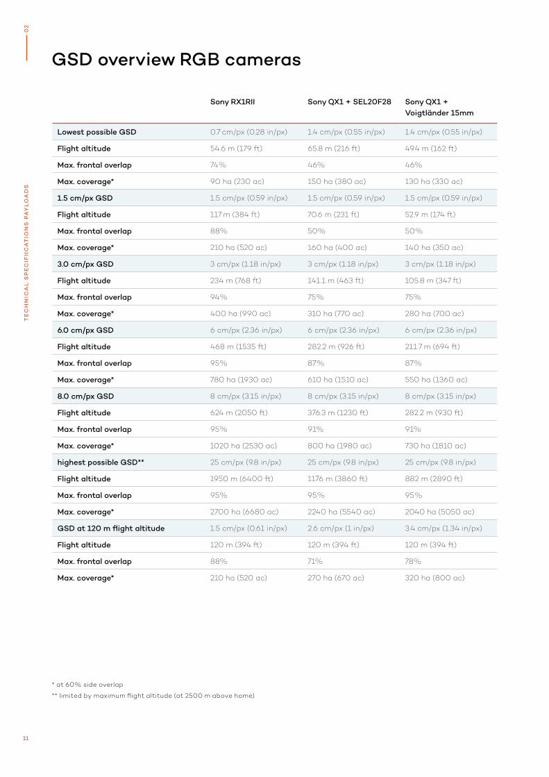
GSD overview RGB cameras
* at 60% side overlap
** limited by maximum flight altitude (at 2500 m above home)
Sony RX1RII Sony QX1 + SEL20F28 Sony QX1 + Voigtländer 15mm
Lowest possible GSD 0.7 cm/px (0.28 in/px) 1.4 cm/px (0.55 in/px) 1.4 cm/px (0.55 in/px)
Flight altitude 54.6 m (179 ft) 65.8 m (216 ft) 49.4 m (162 ft)
Max. frontal overlap 74% 46% 46%
Max. coverage* 90 ha (230 ac) 150 ha (380 ac) 130 ha (330 ac)
1.5 cm/px GSD 1.5 cm/px (0.59 in/px) 1.5 cm/px (0.59 in/px) 1.5 cm/px (0.59 in/px)
Flight altitude 117 m (384 ft) 70.6 m (231 ft) 52.9 m (174 ft)
Max. frontal overlap 88% 50% 50%
Max. coverage* 210 ha (520 ac) 160 ha (400 ac) 140 ha (350 ac)
3.0 cm/px GSD 3 cm/px (1.18 in/px) 3 cm/px (1.18 in/px) 3 cm/px (1.18 in/px)
Flight altitude 234 m (768 ft) 141.1 m (463 ft) 105.8 m (347 ft)
Max. frontal overlap 94% 75% 75%
Max. coverage* 400 ha (990 ac) 310 ha (770 ac) 280 ha (700 ac)
6.0 cm/px GSD 6 cm/px (2.36 in/px) 6 cm/px (2.36 in/px) 6 cm/px (2.36 in/px)
Flight altitude 468 m (1535 ft) 282.2 m (926 ft) 211.7 m (694 ft)
Max. frontal overlap 95% 87% 87%
Max. coverage* 780 ha (1930 ac) 610 ha (1510 ac) 550 ha (1360 ac)
8.0 cm/px GSD 8 cm/px (3.15 in/px) 8 cm/px (3.15 in/px) 8 cm/px (3.15 in/px)
Flight altitude 624 m (2050 ft) 376.3 m (1230 ft) 282.2 m (930 ft)
Max. frontal overlap 95% 91% 91%
Max. coverage* 1020 ha (2530 ac) 800 ha (1980 ac) 730 ha (1810 ac)
highest possible GSD** 25 cm/px (9.8 in/px) 25 cm/px (9.8 in/px) 25 cm/px (9.8 in/px)
Flight altitude 1950 m (6400 ft) 1176 m (3860 ft) 882 m (2890 ft)
Max. frontal overlap 95% 95% 95%
Max. coverage* 2700 ha (6680 ac) 2240 ha (5540 ac) 2040 ha (5050 ac)
GSD at 120 m flight altitude 1.5 cm/px (0.61 in/px) 2.6 cm/px (1 in/px) 3.4 cm/px (1.34 in/px)
Flight altitude 120 m (394 ft) 120 m (394 ft) 120 m (394 ft)
Max. frontal overlap 88% 71% 78%
Max. coverage* 210 ha (520 ac) 270 ha (670 ac) 320 ha (800 ac)
11
02
TE
CH
NIC
AL
SP
EC
IFII
CA
TIO
NS
PA
YL
OA
DS
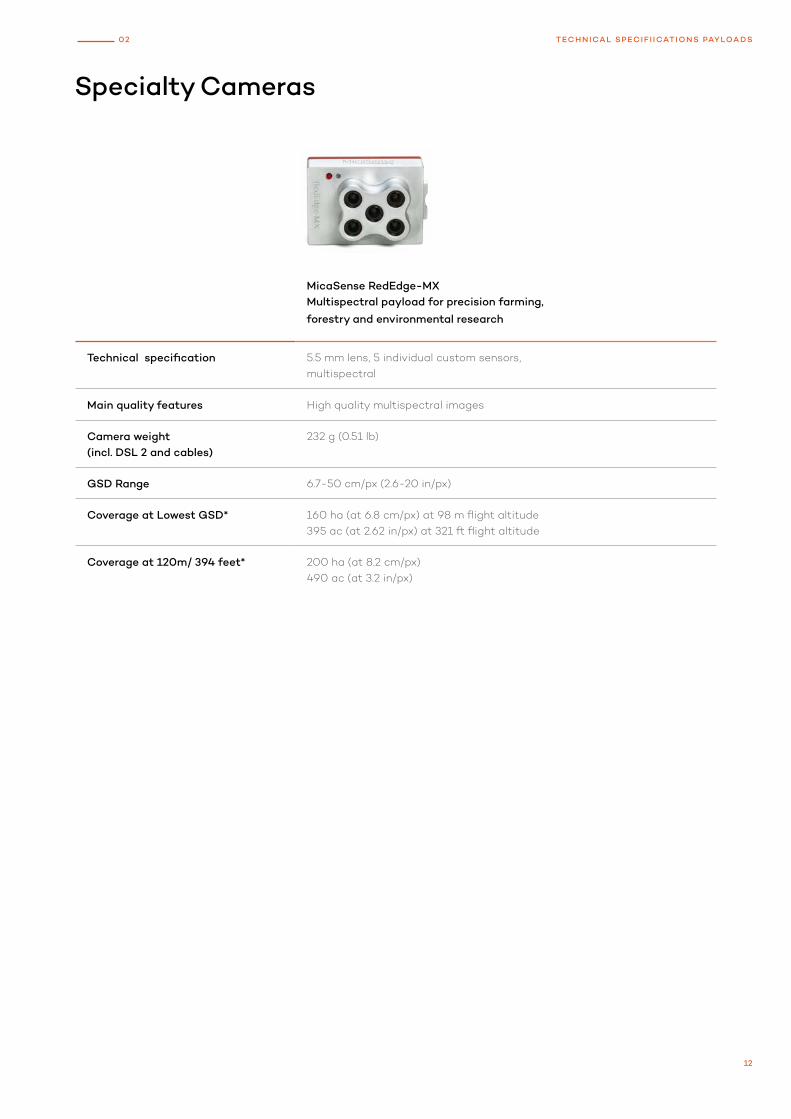
Specialty Cameras
MicaSense RedEdge-MXMultispectral payload for precision farming,
forestry and environmental research
Technical specification 5.5 mm lens, 5 individual custom sensors, multispectral
Main quality features High quality multispectral images
Camera weight (incl. DSL 2 and cables)
232 g (0.51 lb)
GSD Range 6.7-50 cm/px (2.6-20 in/px)
Coverage at Lowest GSD* 160 ha (at 6.8 cm/px) at 98 m flight altitude395 ac (at 2.62 in/px) at 321 ft flight altitude
Coverage at 120m/ 394 feet* 200 ha (at 8.2 cm/px)490 ac (at 3.2 in/px)
12
02 TECHNICAL SPECIF I ICATIONS PAYLOADS
Technical specifications of specialty cameras
Micasense Rededge-MX
Sensor type 5 individual sensors
Sensor size x 4.8 mm (0.19 in)
Sensor size y 3.6 mm (0.14 in)
Mega pixel 5 × 1.22
Shutter type electronic shutter
Pixel in x 1280
Pixel in y 960
Focal length of lens 5.5 mm (0.22 in)
Focal length (35mm equivalent) 40 mm (1.57 in)
Veritcal angle of view 36.2°
Horizontal angle of view 47.1°
Minimal trigger time 1 s
Minimal trigger distance 16 m (52 ft)
13
02
TE
CH
NIC
AL
SP
EC
IFII
CA
TIO
NS
PA
YL
OA
DS
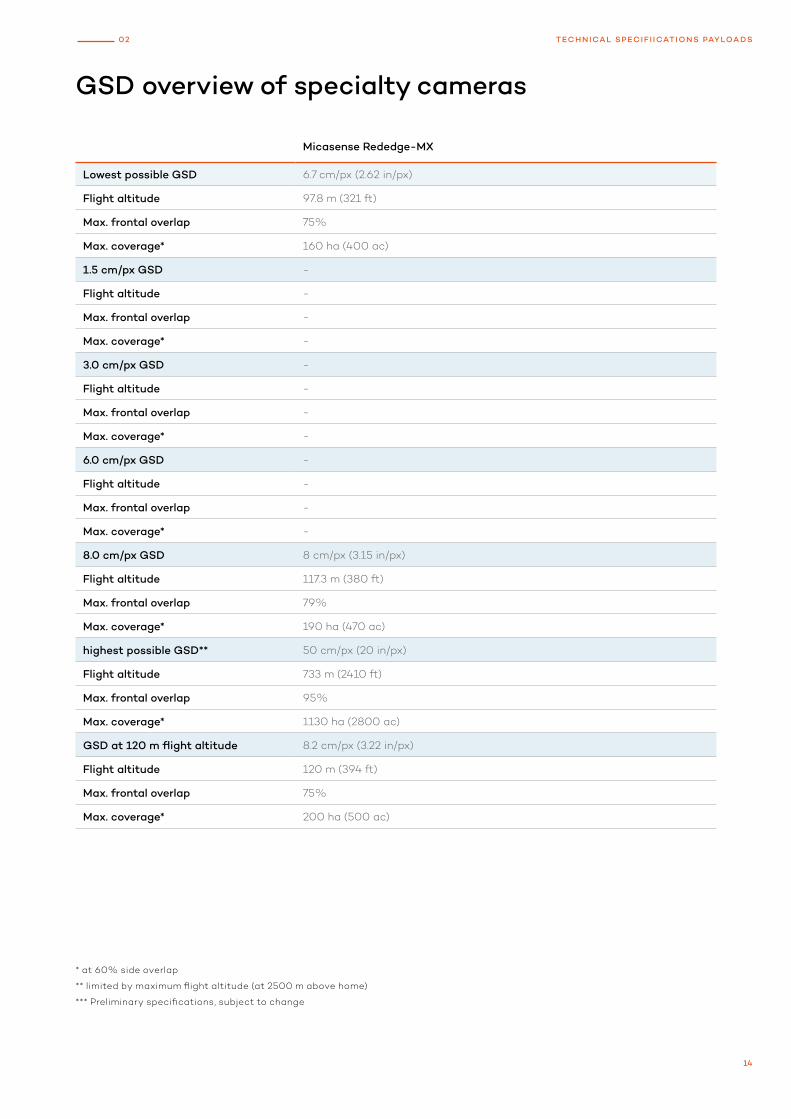
GSD overview of specialty cameras
Micasense Rededge-MX
Lowest possible GSD 6.7 cm/px (2.62 in/px)
Flight altitude 97.8 m (321 ft)
Max. frontal overlap 75%
Max. coverage* 160 ha (400 ac)
1.5 cm/px GSD -
Flight altitude -
Max. frontal overlap -
Max. coverage* -
3.0 cm/px GSD -
Flight altitude -
Max. frontal overlap -
Max. coverage* -
6.0 cm/px GSD -
Flight altitude -
Max. frontal overlap -
Max. coverage* -
8.0 cm/px GSD 8 cm/px (3.15 in/px)
Flight altitude 117.3 m (380 ft)
Max. frontal overlap 79%
Max. coverage* 190 ha (470 ac)
highest possible GSD** 50 cm/px (20 in/px)
Flight altitude 733 m (2410 ft)
Max. frontal overlap 95%
Max. coverage* 1130 ha (2800 ac)
GSD at 120 m flight altitude 8.2 cm/px (3.22 in/px)
Flight altitude 120 m (394 ft)
Max. frontal overlap 75%
Max. coverage* 200 ha (500 ac)
* at 60% side overlap
** limited by maximum flight altitude (at 2500 m above home)
*** Preliminary specifications, subject to change
14
02 TECHNICAL SPECIF I ICATIONS PAYLOADS

15
0
0N
OT
ES

Wingtra AG Giesshübelstrasse 408045 Zürich, Switzerland
For a quote, a live demonstration or more information
on the Wingtra products please contact us via
wingtra.com or [email protected]