Embed Size (px)
Citation preview
389Eng Sanit Ambient | v.26 n.3 | maio/jun 2021 | 389-399
ABSTRACTPopulation progress is one of the main factors affecting the
environment, modifying the natural dynamics of ecosystems.
The Camboriú River Basin is located on the southern coast of Brazil
and is strongly affected by population growth. This paper aimed to
verify the space-time variation in the land use of the Camboriú River
Basin by identifying changes in occupation and land use between
1986 and 2017. The rapid environmental assessment protocol was
applied using the following parameters: bottom substrate, habitat
complexity, backwaters quality, stability of banks, vegetative
protection, vegetative cover, vegetative quality, and riparian
vegetation presence. The changes in occupation and land use show
rapid urbanization with a rise of 9% in 1986 to 24% in 2017. In riparian
forest, higher altitude regions of the watershed show better results
when compared to lower course regions, which are, thus, reflected
in the environmental integrity of the stretches of stream studied.
As for the behavior of urban occupation in space, it was verified that
it did not occur continuously in comparison with the population, data
during the studied period.
Keywords: anthropogenic pressure; water resources; land use.
1Universidade do Vale do Itajaí – Itajaí (SC), Brazil.*Corresponding author: [email protected] of interest: the authors declare no conflicts of interest.Funding: none.Received: 03/17/2019 – Accepted: 10/28/2019 – Reg. ABES: 20190080
Technical Article
Spatial-temporal variation in land use in a coastal watershed under pressure of population growth
Variação espaço-temporal no uso do solo em uma bacia hidrográfica costeira sob pressão do crescimento populacional
Dafne Duani Pereira da Silva1* , Paulo Ricardo Schwingel1
RESUMOO avanço populacional é um dos principais fatores de alteração do meio
ambiente, modificando as dinâmicas naturais dos ecossistemas. A Bacia
Hidrográfica do Rio Camboriú localiza-se no litoral sul do Brasil e é fortemente
afetada pelo crescimento populacional. O presente trabalho teve como objetivo
verificar a variação espaço-temporal no uso do solo da Bacia Hidrográfica do Rio
Camboriú. Para tanto, foram identificadas mudanças no uso e ocupação do solo
ocorridas entre 1986 e 2017. Além disso, foi aplicado o protocolo de avaliação
rápida do ambiente, sendo verificados os parâmetros: substrato de fundo,
complexidade do habitat, qualidade dos remansos, estabilidade dos barrancos,
proteção vegetal dos barrancos, cobertura vegetal das margens, qualidade
vegetal das margens e presença de mata ciliar. As mudanças no uso e ocupação
do solo mostraram rápido avanço da urbanização, passando de 9% em 1986,
para 24% em 2017. Com relação à mata ciliar, foi verificado que regiões altas da
bacia hidrográfica apresentaram melhores resultados, quando comparadas às
áreas potamais, fato que apresentou similaridade com a integridade ambiental
dos trechos de cursos d’água estudados. Quanto ao comportamento da
ocupação urbana no espaço ao longo do período estudado, verificou-se que este
não ocorreu de forma contínua em comparação com os dados populacionais.
Palavras-chave: pressão antropogênica; recursos hídricos; uso do solo.
INTRODUCTIONRivers and tributaries are the aquatic ecosystems most affected by human activ-ity. Those located in coastal regions when associated with disordered indus-trial and urban growth suffer adverse consequences in their environmental quality (TUNDISI; TUNDISI, 2008). The contamination of water resources by anthropogenic activities not only reduces the economic potential of the waters (FIQUEPRON; GARCIA; STENGER, 2013), but also restricts its use for leisure and recreation by presenting a risk to the health of the population.
A key part in the maintenance of quality water resources is made by the riparian forest, which, as an ecotone between the terrestrial and aquatic
environments, provides protection to the watercourses. Riparian zones supply shelter for biota by detritus deposition (branches, trunks, leaves), help stabilize the banks with tree roots, filter sediment in runoff, and store water in the soil in order to refill the water table and the watercourses in periods of lower rainfall (DOSSKEY et al., 2010; ELMORE; BESCHTA, 1987; LACERDA; FIGUEIREDO, 2009; LIMA; ZAKIA, 2000). Despite vast knowledge about the importance of the riparian forest, there has been a reduction with the advancement of popu-lation. Land use represented by urban and rural occupation and some types of crops alters the riparian forest which directly and indirectly affects the integrity of the adjacent water resources (BREN, 1993; CAMPOS; RAMIRES; PAULA,
https://doi.org/10.1590/S1413-415220190080
390 Eng Sanit Ambient | v.26 n.3 | maio/jun 2021 | 389-399
Silva, D.D.P. & Schwingel, P.R.
2011; DONADIO; GALBIATTI; PAULA, 2005; EROL; RANDHIR, 2013; FOLEY et al., 2005; SOUZA; GASTALDINI, 2014; MORING; GARMAN; MULLEN, 1985; POLETO; CARVALHO; MATSUMOTO, 2010; SANTOS; HERNANDEZ, 2013; TUCCI, 2002; VANZELA; HERNANDEZ; FRANCO, 2010).
Statewide, the Camboriú River Watershed is part of the hydrographic region RH7, Itajaí Valley, located in the municipalities of Camboriú and Balneário Camboriú, Santa Catarina State (SANTA CATARINA, 2008). According to the Brazilian Institute of Geography and Statistics demographic census, the munici-palities which compose this Basin show accelerated population growth (IBGE, 2018). Furthermore, it shows that Balneário Camboriú is the municipality with the highest population density in the state of Santa Catarina (2,337.67 inhabit-ants/km2), tending to grow through verticalization. However, the expansion to less inhabited regions such as Camboriú is inevitable due to urban mobility and lack of water supply (PIATTO; POLETTE, 2012). The authors further hold that during holiday season the population of Balneário Camboriú increases tenfold, which overloads basic sanitation systems that are unequipped for such large fluctuations of inhabitants.
Agglomerated population growth poses a risk to the environment due to the concentrated exploitation of natural resources through the expansion of cultivated areas (mainly riziculture), mining, and logging for charcoal and cattle pastures. Studies carried out by Urban (2008) and Padilha (2013) in the
Camboriú River Basin showed signs of this degradation, mainly in relation to the permanent preservation areas where it was verified that more than half of these limits are represented by uses different from vegetal occupation.
In this context, the present study aims to diagnose and dimension the current conditions and land use evolution in light of the pressure exerted by population growth in the Camboriú River Watershed, verifying whether the spatiotemporal distribution of these uses presents a linear model (continuous) or shows pulses over time.
METHODOLOGY
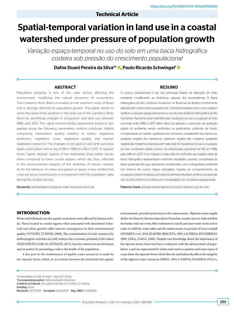
Study areaThe study area comprises the region occupied by the Camboriú River Watershed, located in the municipalities of Camboriú and Balneário Camboriú, central-north coast of the state of Santa Catarina, Brazil (Figure 1).
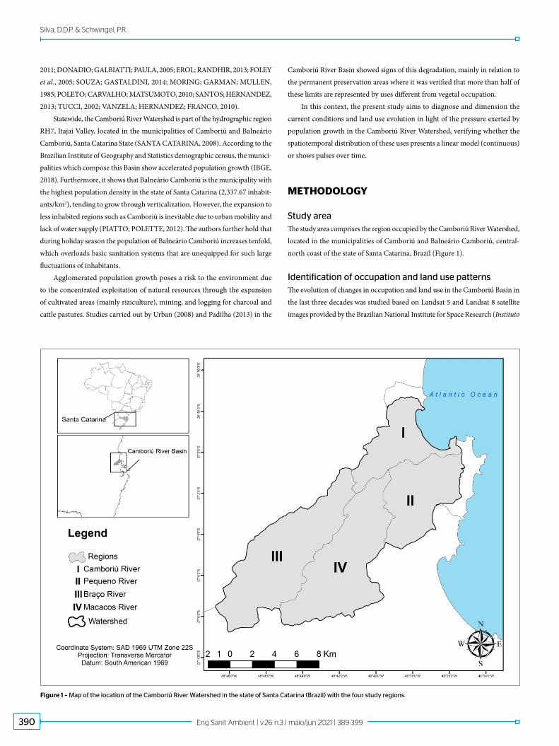
Identification of occupation and land use patternsThe evolution of changes in occupation and land use in the Camboriú Basin in the last three decades was studied based on Landsat 5 and Landsat 8 satellite images provided by the Brazilian National Institute for Space Research (Instituto
Figure 1 – Map of the location of the Camboriú River Watershed in the state of Santa Catarina (Brazil) with the four study regions.

391Eng Sanit Ambient | v.26 n.3 | maio/jun 2021 | 389-399
Spatial-temporal variation in land use in a coastal watershed under pressure of population growth
Nacional de Pesquisas Espaciais – INPE). The years used in the analysis were chosen based on the availability and visibility of the satellites images for the study area, being 1986, 1993, 2004, 2006, 2010, and 2017.
Using photo interpretation with the ArcGis 10.0 software, land occupation was classified into agriculture (where irrigated rice crop predominates), urban area, natural area (presence of medium and advanced stage vegetation), pas-ture/undergrowth, and water mirror. The uses were chosen based on the qual-ity of the satellite images, making classes such as reforestation areas difficult to interpret. From the analysis it was possible to verify the progress of land use in the area covered by the Camboriú River Basin in the study years. The results of the evolution of land use occupation were analyzed through descriptive statis-tics and in the form of maps and were subsequently compared with population data obtained by the Brazilian Institute of Geography and Statistics (Instituto Brasileiro de Geografia e Estatística – IBGE).
Riparian forest analysisThe methodologies proposed by Minatti-Ferreira and Beaumord (2006), Cionek, Beaumord and Benedito (2011) and Leal (2012) were applied to determine the condition of the riparian forest along the tributaries of the Camboriú River Basin using aerial images obtained by the Government of the state of Santa Catarina, a photogeoreferenced survey carried out by the Camboriú Committee (2013), and field visits. The methodologies are based on the determination of the quality of the environment through the application of a protocol using parameters directed to the riparian forest. For such, six field trips were carried out between June and August 2015, where 171 points of the River Basin were evaluated throughout four regions: Camboriú River (13), Pequeno River (28), Braço River (72), and Macacos River (58) (Figure 1).
For the classification of the riparian forest, presence and state param-eters were considered. Five classification intervals were defined for the pres-ence parameter and four for the riparian forest state. The presence of the riparian forest is the existence of vegetation inside the riverbank plotted according to the distances provided in the Brazilian Forest Code of 2012, quantified through the ArcGis 10.0 software, without considering the pro-visions in the consolidated areas until July 22nd, 2008 due to its difficult identification (BRASIL, 2012). In this way, it was possible to identify the presence of riparian forest within the limits imposed by legislation through the aerophotogrammetry of the watershed and to classify the area accord-ing to the methodology of Leal (2012). The state of the riparian forest is determined by the following parameters applied in field visits: the vegetal quality of the margins, the vegetal cover of the banks, the vegetal protec-tion of the ravines, and its stability.
Application of the rapid environmental integrity assessment protocolThe Rapid Assessment Protocol (RAP) of the environment was based on the simplified model of Minatti-Ferreira and Beaumord (2006), which consists of the in situ observation of the environment for analysis of different param-eters through a scoring system which will eventually score the environment in a range from optimum to poor. The RAP includes the parameters of: bot-tom substrate, habitat complexity, and backwater quality. Through field visits and the photogeorreferenced survey provided by the Camboriú Committee, the environmental integrity of the tributaries of the Camboriú River Basin
was determined. The RAP was applied only to streams and upstream regions of the basin, resulting in 54 sample points analyzed.
RESULTS AND DISCUSSION
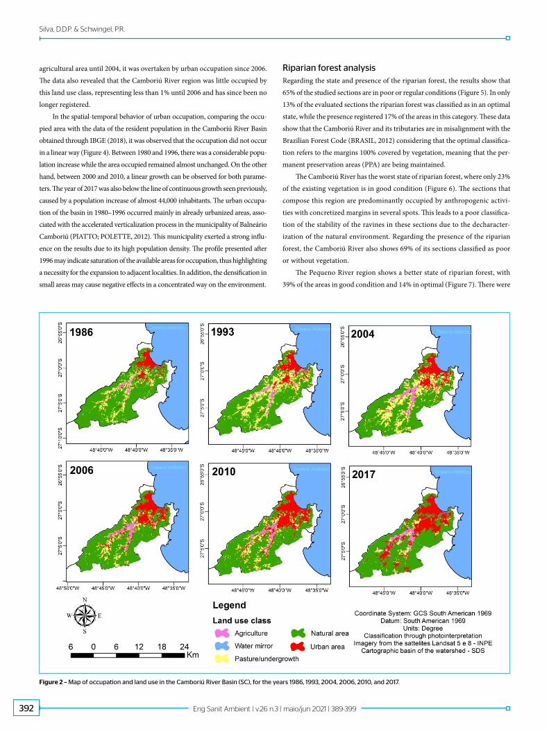
Land use and occupation patternsThe occupation and land use classification enabled visualize the distribution and quantification of urban, agricultural, natural, and pasture/undergrowth areas in the Camboriú River Basin (Figures 2 and 3; Table 1). Although it is still the most representative class in the basin, the natural area suffered the greatest percent-age reduction, reaching almost 10% between 1986 and 1993. In 2006, natural areas began to grow again in places formerly occupied by pasture/undergrowth. The Camboriú River region has the lowest vegetal representation among the stud-ied localities while also seeing the greatest percentage reduction in this class of land use during the period 1986–2017, reaching approximately 12% (Figure 3A).
Difficult access to some forest areas due to hills helps to maintain a great part of its extension, although urban occupation has also advanced in these regions, mainly from 2004 onwards. A study of the Camboriú River Basin by Dortzbach et al. (2015) shows that areas with declivity above 20% are repre-sented mainly by forest cover, confirming the hypothesis that difficult access helps to preserve vegetation. On the other hand, the increase of natural areas in environments exposed to stressful factors may be associated with the abandon-ment of cultivated areas and pasture and planting of species for wood exploita-tion (DORTZBACH et al., 2015; RUDEL et al., 2005; YACKULIC et al., 2011).
The area occupied by pasture/undergrowth increased more than 8% between 1986 and 1993, including in the upper reaches of the basin, regions such as the Braço and Macacos Rivers. The removal of native vegetation for eucalyptus plan-tations or cattle occupation in these regions was observed during field visits. This class presents great variation of area in the basin with different land uses over time, a fact also observed in the studies of Yackulic et al. (2011), in Puerto Rico, and Dortzbach et al. (2015) in the Camboriú River Basin.
Urban area increased from 9 to 10% in the period of 1986–1993, reaching 24% of the land occupation in 2017, making it the class of highest growth in the watershed. The increase of urban areas was more notable in the Camboriú River and Pequeno River regions, in which a gradual densification of urban areas was observed (Figures 3A and 3B). The Pequeno River and the Macacos River regions contain upper areas where new patches of urban occupation were also registered, including near the water springs. In the Pequeno River region, urban area increased from 11% in 1986 to 35% in 2017, the highest relative growth in the Camboriú River Basin. Conversely, the Braço River and Macacos River regions had the lowest urban occupation, however its extension has doubled in the Macacos region between 2006 and 2010. The urbanization process is strongly related to forest cover loss, a fact pointed out by Campos and Souza (2003) while studying the rate of deforestation and colonization of the island of Puerto Rico, Paraná, Brazil.
In general, the agricultural areas remained stable throughout the period, reaching almost 5% of occupation. Agriculture is located mostly in the region of Macacos River, where there was an increase between 1993 and 2006, followed by a reduction in 2010. Furthermore, between 1986 and 2006 there were more agricultural than urban areas in this region, however, the situation was reversed in 2010. The same was verified in the Braço River region, with a representative
392 Eng Sanit Ambient | v.26 n.3 | maio/jun 2021 | 389-399
Silva, D.D.P. & Schwingel, P.R.
agricultural area until 2004, it was overtaken by urban occupation since 2006. The data also revealed that the Camboriú River region was little occupied by this land use class, representing less than 1% until 2006 and has since been no longer registered.
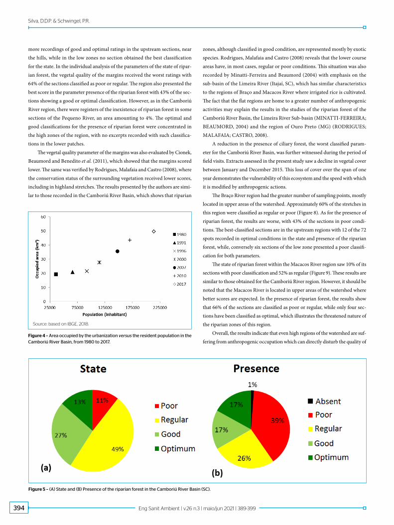
In the spatial-temporal behavior of urban occupation, comparing the occu-pied area with the data of the resident population in the Camboriú River Basin obtained through IBGE (2018), it was observed that the occupation did not occur in a linear way (Figure 4). Between 1980 and 1996, there was a considerable popu-lation increase while the area occupied remained almost unchanged. On the other hand, between 2000 and 2010, a linear growth can be observed for both parame-ters. The year of 2017 was also below the line of continuous growth seen previously, caused by a population increase of almost 44,000 inhabitants. The urban occupa-tion of the basin in 1980–1996 occurred mainly in already urbanized areas, asso-ciated with the accelerated verticalization process in the municipality of Balneário Camboriú (PIATTO; POLETTE, 2012). This municipality exerted a strong influ-ence on the results due to its high population density. The profile presented after 1996 may indicate saturation of the available areas for occupation, thus highlighting a necessity for the expansion to adjacent localities. In addition, the densification in small areas may cause negative effects in a concentrated way on the environment.
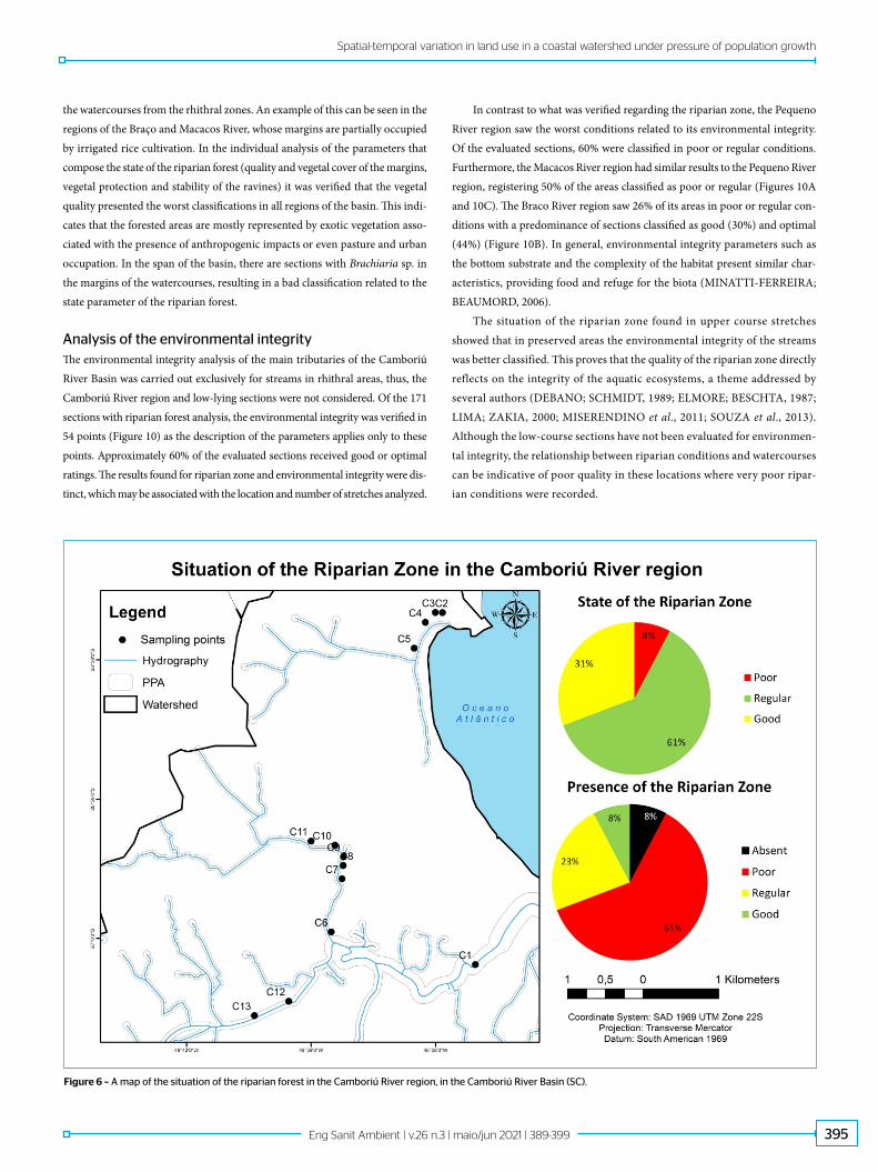
Riparian forest analysisRegarding the state and presence of the riparian forest, the results show that 65% of the studied sections are in poor or regular conditions (Figure 5). In only 13% of the evaluated sections the riparian forest was classified as in an optimal state, while the presence registered 17% of the areas in this category. These data show that the Camboriú River and its tributaries are in misalignment with the Brazilian Forest Code (BRASIL, 2012) considering that the optimal classifica-tion refers to the margins 100% covered by vegetation, meaning that the per-manent preservation areas (PPA) are being maintained.
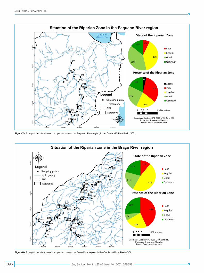
The Camboriú River has the worst state of riparian forest, where only 23% of the existing vegetation is in good condition (Figure 6). The sections that compose this region are predominantly occupied by anthropogenic activi-ties with concretized margins in several spots. This leads to a poor classifica-tion of the stability of the ravines in these sections due to the decharacter-ization of the natural environment. Regarding the presence of the riparian forest, the Camboriú River also shows 69% of its sections classified as poor or without vegetation.
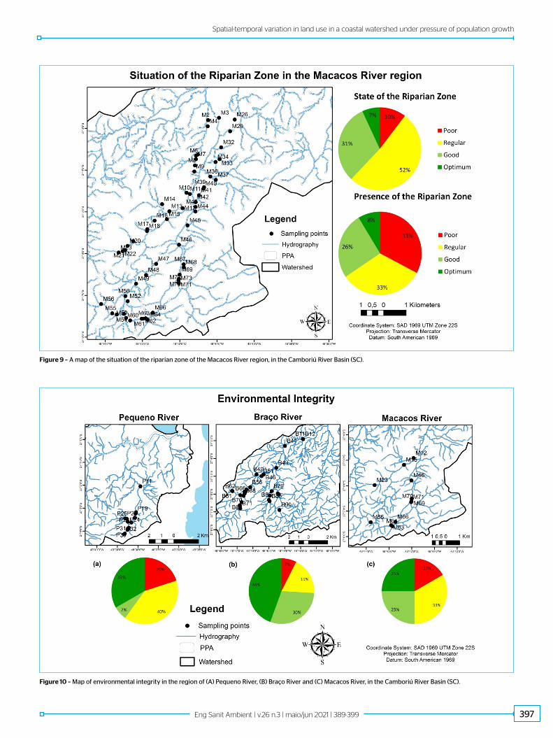
The Pequeno River region shows a better state of riparian forest, with 39% of the areas in good condition and 14% in optimal (Figure 7). There were
Figure 2 – Map of occupation and land use in the Camboriú River Basin (SC), for the years 1986, 1993, 2004, 2006, 2010, and 2017.
393Eng Sanit Ambient | v.26 n.3 | maio/jun 2021 | 389-399
Spatial-temporal variation in land use in a coastal watershed under pressure of population growth
Figure 3 – Area occupied by each class of land use in (A) Camboriú River region, (B) Pequeno River region, (C) Braço River region and (D) Macacos River region, Camboriú River Basin (SC).
Table 1 – Percentage of occupation of each class, for the 1986–2017 period, in the Camboriú River Basin (SC).
ClassYear/Occupation (%)
1986 1993 1999 2004 2006 2010 2017
Urban area 9.43 10.19 10.49 13.53 17.50 21.18 24.18
Natural area 73.72 64.30 62.88 59.23 67.65 63.38 65.51
Pasture/ undergrowth 13.40 21.42 23.62 22.71 10.63 11.84 4.85
Agriculture 1.97 2.57 2.51 4.07 3.77 3.23 4.94
Water mirror 0.40 0.65 0.50 0.45 0.45 0.37 0.51
No class 1.09 0.87 0.00 0.00 0.00 0.00 0.00
394 Eng Sanit Ambient | v.26 n.3 | maio/jun 2021 | 389-399
Silva, D.D.P. & Schwingel, P.R.
Source: based on IBGE, 2018.
Figure 4 – Area occupied by the urbanization versus the resident population in the Camboriú River Basin, from 1980 to 2017.
Figure 5 – (A) State and (B) Presence of the riparian forest in the Camboriú River Basin (SC).
more recordings of good and optimal ratings in the upstream sections, near the hills, while in the low zones no section obtained the best classification for the state. In the individual analysis of the parameters of the state of ripar-ian forest, the vegetal quality of the margins received the worst ratings with 64% of the sections classified as poor or regular. The region also presented the best score in the parameter presence of the riparian forest with 43% of the sec-tions showing a good or optimal classification. However, as in the Camboriú River region, there were registers of the inexistence of riparian forest in some sections of the Pequeno River, an area amounting to 4%. The optimal and good classifications for the presence of riparian forest were concentrated in the high zones of the region, with no excerpts recorded with such classifica-tions in the lower patches.
The vegetal quality parameter of the margins was also evaluated by Cionek, Beaumord and Benedito et al. (2011), which showed that the margins scored lower. The same was verified by Rodrigues, Malafaia and Castro (2008), where the conservation status of the surrounding vegetation received lower scores, including in highland stretches. The results presented by the authors are simi-lar to those recorded in the Camboriú River Basin, which shows that riparian
zones, although classified in good condition, are represented mostly by exotic species. Rodrigues, Malafaia and Castro (2008) reveals that the lower course areas have, in most cases, regular or poor conditions. This situation was also recorded by Minatti-Ferreira and Beaumord (2004) with emphasis on the sub-basin of the Limeira River (Itajaí, SC), which has similar characteristics to the regions of Braço and Macacos River where irrigated rice is cultivated. The fact that the flat regions are home to a greater number of anthropogenic activities may explain the results in the studies of the riparian forest of the Camboriú River Basin, the Limeira River Sub-basin (MINATTI-FERREIRA; BEAUMORD, 2004) and the region of Ouro Preto (MG) (RODRIGUES; MALAFAIA; CASTRO, 2008).
A reduction in the presence of ciliary forest, the worst classified param-eter for the Camboriú River Basin, was further witnessed during the period of field visits. Extracts assessed in the present study saw a decline in vegetal cover between January and December 2015. This loss of cover over the span of one year demonstrates the vulnerability of this ecosystem and the speed with which it is modified by anthropogenic actions.
The Braço River region had the greater number of sampling points, mostly located in upper areas of the watershed. Approximately 60% of the stretches in this region were classified as regular or poor (Figure 8). As for the presence of riparian forest, the results are worse, with 43% of the sections in poor condi-tions. The best-classified sections are in the upstream regions with 12 of the 72 spots recorded in optimal conditions in the state and presence of the riparian forest, while, conversely six sections of the low zone presented a poor classifi-cation for both parameters.
The state of riparian forest within the Macacos River region saw 10% of its sections with poor classification and 52% as regular (Figure 9). These results are similar to those obtained for the Camboriú River region. However, it should be noted that the Macacos River is located in upper areas of the watershed where better scores are expected. In the presence of riparian forest, the results show that 66% of the sections are classified as poor or regular, while only four sec-tions have been classified as optimal, which illustrates the threatened nature of the riparian zones of this region.
Overall, the results indicate that even high regions of the watershed are suf-fering from anthropogenic occupation which can directly disturb the quality of
395Eng Sanit Ambient | v.26 n.3 | maio/jun 2021 | 389-399
Spatial-temporal variation in land use in a coastal watershed under pressure of population growth
the watercourses from the rhithral zones. An example of this can be seen in the regions of the Braço and Macacos River, whose margins are partially occupied by irrigated rice cultivation. In the individual analysis of the parameters that compose the state of the riparian forest (quality and vegetal cover of the margins, vegetal protection and stability of the ravines) it was verified that the vegetal quality presented the worst classifications in all regions of the basin. This indi-cates that the forested areas are mostly represented by exotic vegetation asso-ciated with the presence of anthropogenic impacts or even pasture and urban occupation. In the span of the basin, there are sections with Brachiaria sp. in the margins of the watercourses, resulting in a bad classification related to the state parameter of the riparian forest.
Analysis of the environmental integrityThe environmental integrity analysis of the main tributaries of the Camboriú River Basin was carried out exclusively for streams in rhithral areas, thus, the Camboriú River region and low-lying sections were not considered. Of the 171 sections with riparian forest analysis, the environmental integrity was verified in 54 points (Figure 10) as the description of the parameters applies only to these points. Approximately 60% of the evaluated sections received good or optimal ratings. The results found for riparian zone and environmental integrity were dis-tinct, which may be associated with the location and number of stretches analyzed.
In contrast to what was verified regarding the riparian zone, the Pequeno River region saw the worst conditions related to its environmental integrity. Of the evaluated sections, 60% were classified in poor or regular conditions. Furthermore, the Macacos River region had similar results to the Pequeno River region, registering 50% of the areas classified as poor or regular (Figures 10A and 10C). The Braco River region saw 26% of its areas in poor or regular con-ditions with a predominance of sections classified as good (30%) and optimal (44%) (Figure 10B). In general, environmental integrity parameters such as the bottom substrate and the complexity of the habitat present similar char-acteristics, providing food and refuge for the biota (MINATTI-FERREIRA; BEAUMORD, 2006).
The situation of the riparian zone found in upper course stretches showed that in preserved areas the environmental integrity of the streams was better classified. This proves that the quality of the riparian zone directly reflects on the integrity of the aquatic ecosystems, a theme addressed by several authors (DEBANO; SCHMIDT, 1989; ELMORE; BESCHTA, 1987; LIMA; ZAKIA, 2000; MISERENDINO et al., 2011; SOUZA et al., 2013). Although the low-course sections have not been evaluated for environmen-tal integrity, the relationship between riparian conditions and watercourses can be indicative of poor quality in these locations where very poor ripar-ian conditions were recorded.
Figure 6 – A map of the situation of the riparian forest in the Camboriú River region, in the Camboriú River Basin (SC).
396 Eng Sanit Ambient | v.26 n.3 | maio/jun 2021 | 389-399
Silva, D.D.P. & Schwingel, P.R.
Figure 7 – A map of the situation of the riparian zone of the Pequeno River region, in the Camboriú River Basin (SC).
Figure 8 – A map of the situation of the riparian zone of the Braço River region, in the Camboriú River Basin (SC).
397Eng Sanit Ambient | v.26 n.3 | maio/jun 2021 | 389-399
Spatial-temporal variation in land use in a coastal watershed under pressure of population growth
Figure 9 – A map of the situation of the riparian zone of the Macacos River region, in the Camboriú River Basin (SC).
Figure 10 – Map of environmental integrity in the region of (A) Pequeno River, (B) Braço River and (C) Macacos River, in the Camboriú River Basin (SC).
398 Eng Sanit Ambient | v.26 n.3 | maio/jun 2021 | 389-399
Silva, D.D.P. & Schwingel, P.R.
BRASIL. Lei nº 12.651, de 25 de maio de 2012. Novo Código Florestal
Brasileiro. Brasil, 2012.
BREN, L.J. Riparian zone, stream, and floodplain issues: a review. Journal
of Hydrology, v. 150, n. 2-4, p. 277-299, 1993. https://doi.org/10.1016/0022-
1694(93)90113-N
CAMPOS, J.B.; SOUZA, M.C. Potential for natural forest regeneration from
seed bank in na upper Paraná river floodplain, Brazil. Brazilian Archives of
Biology and Technology, v. 46, n. 4, p. 625-639, 2003. https://doi.org/10.1590/
S1516-89132003000400018
CAMPOS, K.B.G; RAMIRES, I.; PAULA, S.M. Influência do uso e ocupação do solo
nos recursos hídricos de quatro córregos na região de Caarapó – MS. Revista de
Ciências Ambientais, Canoas, v. 5, n. 2, p. 77-92, 2011. https://doi.org/10.18316/263
CIONEK, V.M.; BEAUMORD, A.C.; BENEDITO, E. Protocolo de avaliação rápida
do ambiente para riachos inseridos na região do Arenito Caiuá – Noroeste
do Paraná. Maringá: Eduem, 2011. 47 p. (Coleção Fundamentum, n. 72).
COMITÊ CAMBORIÚ. Levantamento Fotogeorreferenciado dos afluentes do rio
Camboriú (SC). Relatório Técnico. Camboriú: Comitê Camboriú, 2013. Available
at: http://docplayer.com.br/10089842-Levantamento-fotogeorreferenciado-
dos-afluentes-do-rio-Camboriú-sc.html. Accessed on: Aug. 16, 2019.
DEBANO, L.F.; SCHMIDT, L.J. Improving southwestern riparian areas
through watershed management. Gen. Tech. Rep. RM-182. Fort Collins: U.S.
Department of Agriculture, Forest Service, Rocky Mountain Forest and
Range Experiment Station, 1989.
DONADIO, N.M.M.; GALBIATTI, J.A.; PAULA, R.C. Qualidade da água de
nascentes com diferentes usos do solo na Bacia Hidrográfica do Córrego
Rico, São Paulo, Brasil. Engenharia Agrícola, Jaboticabal, v. 25, n. 1, p. 115-125,
2005. https://doi.org/10.1590/S0100-69162005000100013
DORTZBACH, D. et al. Análise da dinâmica da paisagem no uso e cobertura
das terras nos municípios de Camboriú e Balneário Camboriú, SC. Caderno
Prudentino de Geografia, Presidente Prudente, v. 2, n. 37, p. 5-26, 2015.
DOSSKEY, M.G. et al. The role of riparian vegetation in protecting and improving
chemical water quality in streams. Journal of the American Resources Association,
v. 46, n. 2, p. 261-277, 2010. https://doi.org/10.1111/j.1752-1688.2010.00419.x
ELMORE, W.; BESCHTA, R.L. Riparian Areas: Perceptions in Management.
Rangelands, v. 9, n. 6, p. 260-265, 1987.
EROL, A.; RANDHIR, T.O. Watershed ecosystem modeling of land-use
impacts on water quality. Ecological Modelling, v. 270, p. 54-63, 2013. https://
doi.org/10.1016/j.ecolmodel.2013.09.005
FIQUEPRON, J.; GARCIA, S.; STENGER, A. Land use impact on water quality:
Valuing forest services in terms of the water supply sector. Journal of
Environmental Management, v. 126, p. 113-121, 2013. https://doi.org/10.1016/j.
jenvman.2013.04.002
FOLEY, J.A. et al. Global consequences of land use. Science, v. 309, n. 5734,
p. 570-574, 2005. https://doi.org/10.1126/science.1111772
INSTITUTO BRASILEIRO DE GEOGRAFIA E ESTATÍSTICA (IBGE). Cidades e
Estados do Brasil. IBG.E Available at: https://cidades.ibge.gov.br/. Accessed
in: May 2018.
LACERDA, D.M.A.; FIGUEIREDO, P.S. Restauração de matas ciliares
do rio Mearim no município de Barra do Corda – MA: seleção de
espécies e comparação de metodologias de reflorestamento. Acta
Amazônica, v. 39, n. 2, p. 295-303, 2009. https://doi.org/10.1590/S0044-
59672009000200008
LEAL, K.P. Bacias hidrográficas dos rios Gravatá e Irirí, municípios de
Navegantes e Penha (SC): caracterização ambiental e recomendações
para orientar políticas públicas. Monograph (Degree in Environmental
Engineering) – Universidade do Vale do Itajaí, Itajaí, 2012.
LIMA, W.P.; ZAKIA, M.J.B. Hidrologia de matas ciliares. In: RODRIGUES, R.R.;
LEITÃO FILHO, H.F. (org.). Matas ciliares: conservação e recuperação. 2. ed.
São Paulo: Editora da Universidade de São Paulo, 2000. p. 33-43.
MINATTI-FERREIRA, D.D.; BEAUMORD, A.C. Adequação de um protocolo
de avaliação rápida de integridade ambiental para ecossistemas de
rios e riachos: Aspectos físicos. Revista Saúde e Ambiente, v. 7, n. 1, p.
39-47, 2006.
MINATTI-FERREIRA, D.D.; BEAUMORD, A.C. Avaliação rápida de integridade
ambiental das sub-bacias do rio Itajaí-Mirim no município de Brusque, SC.
Revista Saúde e Ambiente, v. 5, n. 2, p. 21-27, 2004.
REFERENCES
FINAL CONSIDERATIONSFrom the results obtained for the Camboriú River Basin (Santa Catarina), in reference to changes in land use and occupation, it was concluded that the urban area of the basin grew by 156% between 1986 and 2017, which led to a reduction of 11% decrease in the natural area during the same period. Although the expansion of urban area was high, this pattern was verified only from the 2000s, thus not presenting a linear model in relation to the number of inhabitants during the studied period. This model of urban occupation over the watershed area is influenced by different external factors which shapes its pattern of dispersion in space. In the case of the studied coastal basin, one characterized by high touristic potential, the growth of urban occupation
occurred vertically. This pattern is associated with periods of elevated popu-lation densification, thus reducing the speed of the land occupation process in adjacent areas until the year 2000.
AUTHORS’ CONTRIBUTIONSPereira-Silva, D. D.: Conceptualization, Data Curation, Formal Analysis, Investigation, Methodology, Validation, Visualization, Writing — Original Draft, Writing — Review & Editing. Schwingel, P. R.: Conceptualization, Data Curation, Formal Analysis, Investigation, Methodology, Supervision, Validation, Visualization, Writing — Review & Editing.
399Eng Sanit Ambient | v.26 n.3 | maio/jun 2021 | 389-399
Spatial-temporal variation in land use in a coastal watershed under pressure of population growth
MISERENDINO, M.L. et al. Assessing land-use effects on water quality,
in-stream habitat, riparian ecosystems and biodiversity in Patagonian
northwest streams. Science of the Total Environment, v. 409, n. 3, p. 612-
624, 2011. https://doi.org/10.1016/j.scitotenv.2010.10.034
MORING, J.R.; GARMAN, G.C.; MULLEN, D.M. The value of riparian zones for
protecting aquatic systems: general concerns and recent studies in Maine.
North American Riparian Conference, Tucson, p. 315-319, 1985.
PADILHA, L.R. Modelagem da qualidade da água na bacia hidrográfica do rio
Camboriú, SC: Subsídios à gestão integrada dos Recursos Hídricos. Monograph
(Degree in Environmental Engineering) – Universidade do Vale do Itajaí, Itajaí, 2013.
PIATTO, L.; POLETTE, M. Análise do processo de artificialização do
município de Balneário Camboriú, SC, Brasil. Revista da Gestão Costeira
Integrada, v. 12, n. 1, p. 77-88, 2012.
POLETO, C.; CARVALHO, S.L.; MATSUMOTO, T. Avaliação da qualidade da
água de uma microbacia hidrográfica no município de Ilha Solteira (SP). Holos
Environment, v. 10, n. 1, p. 95-110, 2010. https://doi.org/10.14295/holos.v10i1.4241
RODRIGUES, A.S.L.; MALAFAIA, G.; CASTRO, P.T.A. Avaliação ambiental de
trechos de rios na região de Ouro Preto – MG através de um protocolo de
avaliação rápida. REA – Revista de Estudos Ambientais, v. 10, n. 1, p. 74-83,
2008. https://doi.org/10.7867/1983-1501.2008v10n1p74-83
RUDEL, T.K. et al. Forest transitions: towards a global understanding of land
use change. Global Environmental Change, v. 15, n. 1, p. 23-31, 2005. https://
doi.org/10.1016/j.gloenvcha.2004.11.001
SANTA CATARINA. Coletânea de legislação de recursos hídricos de Santa
Catarina. 2. ed. Florianópolis: SDS / DRHI, 2008.
SANTOS, G.O.; HERNANDEZ, F.B.T. Uso do solo e monitoramento dos
recursos hídricos no córrego do Ipê, Ilha Solteira, SP. Revista Brasileira
de Engenharia Agrícola e Ambiental, v. 17, n. 1, p. 60-68, 2013. https://doi.
org/10.1590/S1415-43662013000100009
SOUZA, A.L.T. et al. Influence of riparian vegetation and forest structure on
the water quality of rural low-order streams in SE Brazil. Forest Ecology and
Management, v. 298, p. 12-18, 2013. https://doi.org/10.1016/j.foreco.2013.02.022
SOUZA, M.M.; GASTALDINI, M.C.C. Avaliação da qualidade da água em
bacias hidrográficas com diferentes impactos antrópicos. Engenharia
Sanitária e Ambiental, v. 19, n. 3, p. 263-274, 2014. https://doi.org/10.1590/
S1413-41522014019000001097
TUCCI, C.E.M. Impactos da variabilidade climática e o uso do solo nos
recursos hídricos. Brasília: Fórum Brasileiro de Mudanças Climáticas, 2002.
TUNDISI, J.G.; TUNDISI, T.M. Limnologia. São Paulo: Oficina de Textos, 2008.
URBAN, S.R. Uso do solo na bacia hidrográfica do rio Camboriú (SC)
e sua influência sobre a qualidade da água. Dissertation (Mastering in
Environmental Science and Technology) – Universidade do Vale do Itajaí,
Itajaí, 2008.
VANZELA, L.S.; HERNANDEZ, F.B.T.; FRANCO, R.A.M. Influência do uso
e ocupação do solo nos recursos hídricos do córrego Três Barras,
Marinópolis. Revista Brasileira de Engenharia Agrícola e Ambiental, v. 14, n. 1,
p. 55-64, 2010. https://doi.org/10.1590/S1415-43662010000100008
YACKULIC, C.B. et al. Biophysical and socioeconomic factors associated
with forest transitions at multiple spatial and temporal scales. Ecology and
Society, v. 16, n. 3, p. 15, 2011. https://doi.org/10.5751/ES-04275-160315
© 2021 Associação Brasileira de Engenharia Sanitária e Ambiental
This is an open access article distributed under the terms of the Creative Commons license.