Embed Size (px)
Citation preview

Technical Assistance Consultant’s Report
Project Number: 45072-001 September 2014
Regional Technical Assistance TA7967-REG Innovations for More Food with Less Water Task 2
Prepared by
Lahmeyer International in association with Lahmeyer International India, BETS Consulting Services, Centre for Environment and Development, and Total Management Services
Asian Development Bank
Draft Final Report – India


ASIAN DEVELOPMENT BANK
DRAFT FINAL REPORT
INNOVATIONS FOR MORE FOOD WITH LESS WATER
TASK 2
RDTA 7967 – REG
SEPTEMBER 2014
This consultant’s report does not necessarily reflect the views of the ADB or the Government
concerned, and ADB and the Government cannot be held liable for its contents. All the views
expressed herein may not be incorporated into the proposed project’s design.

More Food with Less Water – Task 2 i Draft Final Report– India
CURRENCY EQUIVALENTS
(as of 30 June 2014)
Currency Unit – Indian Rupee (Rs)
Rs.1.00 = $0.167 $1.00 = Rs.60
ABBREVIATIONS
ADB – Asian Development Bank
BADC – Bangladesh Agriculture Development Corporation
BRBIP – Bagmati River Basin Improvement Project
BWDB – Bangladesh Water Development Board
CAD – Command Area Development
CWC – Central Water Commission (India)
DIP -- Dharoi Irrigation Project
DAE – Department of Agricultural Extension
DMF – Design and Monitoring Framework
WRD – Department of Irrigation
EA – executing agency
FAO – United Nations Food and Agriculture Organization
FCDI – flood control, drainage and irrigation
FFS – farmer field school
FGD – focus group discussion
GDP – gross domestic product
GOI – Government of India
GON – Government of Nepal
GPWM – Guidelines for Participatory Water Management
ha – hectare
HVC – high value crop
HYV – high yielding variety
I&D – irrigation and drainage
IE – irrigation efficiency
IMIIP – Irrigation Management Improvement Investment Program
IMIP – Irrigation Management Improvement Program
IPCC – Intergovernmental Panel on Climate Change
IR – Inception Report
ISC – irrigation service charge
ISF – irrigation service fee
KM – Kilometer
LGED – Local Government Engineering Department
LLP – low lift pump
MFLW – More Food with Less Water
MOF – Ministry of Finance
More Food with Less Water – Task 2 ii Draft Final Report– India
MOM – Management, Operation and Management
MOWR – Ministry of Water Resources
MOU – Memorandum of Understanding
MT – million tons
OFD – on-farm development
O&M – operation and maintenance
NDVI – normalized difference vegetation index
NGO – non-governmental organization
NWM – National Water Mission (India)
NWMP – National Water Management Plan (Bangladesh)
NWP – National Water Policy
NWRC – National Water Resources Council
NWUEISP – National Water Use Efficiency Improvement Support Program
PIM – participatory irrigation management
POW – productivity of water
PPTA – project preparatory technical assistance
PRA – participatory rural appraisal
QCBS – quality and cost based selection
RAP – rapid appraisal process
RDTA – Research and Development Technical Assistance
RP – Resettlement Plan
RPA – rapid performance assessment
RRP – Report and Recommendations of the President
SA – social assessment
SAP – sample area profiles
SCADA – supervisory control and data acquisition
SPS – Safeguard Policy Statement
SRI – System of Rice Intensification
SSIP – Sanjay Sarovar Irrigation Project
TA – Technical Assistance
ToR – terms of reference
UNFCC – United Nations Framework Convention on Climate Change
WALMI – Water and Land Management Institute
WRD – State Water Resources Departments
WUA – water users association
WUE – Water use efficiency

More Food with Less Water – Task 2 iii Draft Final Report– India

More Food with Less Water – Task 2 iv Draft Final Report– India
EXECUTIVE SUMMARY
A. Introduction
1. The Asian Development Bank (ADB) is financing the research and development technical assistance (RDTA) called Innovations for More Food with Less Water (MFLW) to support the identification, assessment, and design of new investments for more sustainable, water-efficient irrigated agriculture in Bangladesh, India and Nepal. The RDTA is divided between two tasks: Task 1 the research and compilation of international best practices, and Task 2 (the subject of this Draft Final Report) for the identification of methods for improving water productivity – growing more food with less water. The RDTA responds directly to ADB’s Operational Plan for sustainable food security and ADB’s Water Operational Plan for 2011-2020,1 which calls for improving the productivity and efficiency of water use through (i) investing in modern irrigation infrastructure, (ii) adopting enabling policies that correctly price the opportunity cost of water, and (iii) strengthening institutions for more efficient and sustainable water management. It is also consistent with the inclusive growth goal of ADB’s Strategy 20202 and the Water Policy3 objective of improving and expanding water service delivery.
2. The MFLW activities for the Indian pilot schemes will be linked to the recently developed framework for assessing and improving water use efficiency (WUE) on medium and major irrigation (MMI) schemes under the National Water Use Efficiency Improvement Support Program (NWUEISP).4 The NWUEISP is supporting the implementation of the National Water Mission (NWM); the study is financed by ADB. The outputs of the MFLW Task 2 studies will be reviewed by the government and ADB; the pilot schemes would be candidate schemes for investment under the NWUEISP.
3. The Task 2 MFLW studies in India started in March 2014. The two pilot schemes selected for study were the Dharoi Irrigation Project (DIP) in Gujarat and the Sanjay Sarovar Irrigation Project (SSIP) in Madhya Pradesh. In addition, reconnaissance studies for small-scale hill irrigation in Sikkim were also carried out. An interim report was submitted to ADB, the Ministry of Water Resources (MOWR), and the Water Resource Departments (WRDs) in the three states in June 2014. Extensive meetings with the WRDs, MOWR and CWC staff in the three states and at central government level have taken place throughout the study period.
B. Analytical Tools
4. The study team used the Food and Agriculture Organization’s Rapid Appraisal Process (RAP), supported by intensive consultations conducted through Participatory Rural Appraisals (PRAs), with support from remote sensing and other analytical tools, to assess the irrigation performance of the Dharoi and Sanjay Sarovar Schemes. The RAP is a knowledge-based toolkit that is useful for quickly and systematically collecting, compiling and organizing, and analyzing information about large canal irrigation systems. The results from the RAP benchmarking have quantified the performance of each pilot project in terms of the quality of water delivery service at each canal level (hydraulic layer) including parameters such as physical infrastructure, water control strategies, communications, maintenance, institutional capacity, and water delivery service, paying
1 ADB. 2011. Water Operational Plan 201-2020. October 2011. Manila.
2 ADB. 2008. Strategy 2020: The Long-Term Strategic Framework of the Asian Development Bank 2008-
2020. Manila. 3 ADB. 2003. Water for All: The Water Policy of the Asian Development Bank. Manila.
4 ADB. 2014. India: Support for the Implementation of the National Water Mission by State Governments in
India: Scoping Study for a National Water Use Efficiency Improvement Support Program. Final Report.
Project SC 100903 IND. India Resident Mission, New Delhi.

More Food with Less Water – Task 2 v Draft Final Report– India
particular attention to important technical and engineering details (the standardized forms cover over 700 questions/data points). The RAP procedures include a project-level water balance framework, as well as important accounting information about water use, yields and economics. The purpose of the benchmarking was to assist the RDTA develop a preliminary framework for strategic irrigation modernization plans and generate a baseline assessment (ie, benchmarking), against which future progress may be measured after investments in modernization. The benchmarking reports prepared for each project contain a detailed overview of the present operation and management of each system based on field visits and consultations with the WRD staff and stakeholders.
C. Benchmarking Findings for the Two Projects
5. The benchmarking results for the SSIP and DIP presented in this report generally reflect a low level of water delivery service and irrigation performance, which was not unexpected because both schemes have been prioritized by the State WRDs and MOWR for modernization. Most of the key internal indicators covering operations and service are low. External indicators such as irrigation efficiency, cost recovery ratio, and productivity were also relatively low, although there is considerable uncertainty in some of the estimates due to apparent inaccuracies in flow measurement, non-standardization of the available records, missing data, assumptions about the extent and timing of groundwater usage, among other factors. There are several categories of explanation for the assessment of low irrigation performance including aging infrastructure and designs flaws, a lack of sufficient cash-flow for regular maintenance, institutional weaknesses and management limitations, and serious difficulties in controlling and measuring water as it is conveyed and distributed to water users. Inflexible designs and difficulties in operations are limiting crop production (yields), cropping intensity, and contributing to the serious problems with unreliable and unequitable service in extensive parts of the command areas. However, while both projects have relatively similar overall service ratings, there are major differences in the components of service and in terms of the constraints and opportunities between them. However, in both projects there are a number of simple operational or design change opportunities available, which will make a significant beneficial impact on the level of water delivery service. The studies found that the present level of water delivery service in both projects is incapable of supporting modern field irrigation management and methods.
6. The proposed irrigation modernization plans for system improvements were developed after the RAP performance benchmarking, including field inspections of the scheme’s physical infrastructure and water management strategies, interviews with professional staff and field operators, and review of engineering technical data and the available design data. The integration of this technical information, with the results from the stakeholder consultations, contributed a better understanding of the canal systems, daily operating procedures, agricultural demands, problems and issues, and goals for the future management of the system. The common improvements to the two pilot projects generally involve upgrades to control and measurement infrastructure, construction of essential new facilities for re-regulation of canal flows, repairs to existing structures, canal lining, and the introduction of decision support systems and remote monitoring networks. A critical feature of future operations will be a more comprehensive and robust water planning process that occurs at the beginning of every irrigation season. This planning process will result in a water management plan that governs all aspects of water deliveries, scheduled maintenance, and cost recovery (payment amounts and fee collection). Another top priority is to overhaul the WRDs’ information management systems in the schemes, including a new detailed GIS survey and mapping of the entire command areas. The scope of work in these proposals involve a substantial amount of technical details and analyses that are important for proper design, but it is critical to consider them in terms of the overall strategic planning as presented in this report.

More Food with Less Water – Task 2 vi Draft Final Report– India
D. Dharoi Irrigation Project (DIP), Gujarat
7. The DIP has a net cultivated command area (CCA) of 95,200 ha. The irrigation water for the scheme is supplied by the Sabarmati Reservoir (Dharoi Dam) with a live storage volume of 735 Mm3, most of the scheme is supplied by gravity, but about 30% is irrigated by small low lift pump units abstracting from the canals. The surface water resources for the scheme are severely restricted; at 50% dependability the surface water irrigation is only sufficient to irrigate about 28,000 ha, while at 75% dependability the surface water irrigable area is 13,000 ha against a planned annual irrigation of about 61,000 ha. The shortage of surface water is met by groundwater through shallow tube wells and dug wells from a shallow aquifer, and deep tubewells from a deep unconfined aquifer. The shallow aquifer is recharged by rainfall and infiltration from the surface water irrigation (possibly pumped from the deep aquifer). There is very limited recharge to the deep aquifer due to the low permeability layer between the two aquifers. Over recent years the yield from the surface water aquifer has been insufficient to meet the needs of irrigation and hence deep wells have increasingly been used provide a reliable water source. The deep aquifer is over-exploited and abstractions are exceeding the recharge rate. The shallow aquifer provides a valuable and sustainable reservoir which is used to buffer the shortfalls of surface water in parts of the command area. There are reports of the shallow water table rising while in other parts, and during dry years, the wells run dry. The deep aquifer is now being extensively used to meet shortfalls of surface and groundwater from the shallow aquifer; the current levels of abstraction however appear to exceed the recharge and there is a need to restrict the level of abstractions from the deep aquifer.
8. The annual cropping intensity in the DIP is about 135% and during the Rabi season about 89% of the command area is cropped; the main crops being wheat (35%), millet (21%), and castor (19%). The current high water consuming cropping patterns and low distribution inefficiencies are not sustainable, and there is a need to move to lower water consuming crops including orchards and establishment of very high efficiency water distribution including micro irrigation.
9. The scheme is a high energy user mainly due to the groundwater pumping, as well as the 30% of the scheme that relies of lift irrigation using small portable pumpsets.
10. Surface water management is also seriously constrained by the severe shortfall of surface water availability. The policy of WRD is to spread the water to all parts of the scheme (extensive irrigation), which results in some offtakes only receiving 30% of the water needs during average years. Surface water use efficiency is currently only about 35%.
11. There is a requirement to increase surface water efficiency through investment in the surface water canal systems and improved irrigation management; this will make some improvements in water availability. An option for an additional second stage of efficiency improvements is proposed through the use of a buried pipe distribution system below the minor/sub-minor canal-level and high-efficiency micro-irrigation, which offers scope for additional water savings and productivity increases. The surface water would supply by gravity to a small storage tank with water pumped by an electric low lift. Groundwater from tubewells would also connect to the distributions system which would be operated to meet the shortfall in surface water. Private tubewell operators would be brought into the scheme through water supply franchises and contracts.
12. The PRAs identified a good level of farmer interest in piped distribution and micro irrigation, but farmers felt they did not have the resources to go it alone and adequate levels of finance, support and training would be required. Water savings may also be achieved through electricity payments based on consumption using prepaid electricity meters.
13. The increase in irrigation surface and groundwater efficiencies will, however,

More Food with Less Water – Task 2 vii Draft Final Report– India
likely result in a reduction in groundwater recharge that may impact on the yields from the shallow aquifer, but which have a limited impact on the deep aquifer. The savings through WUE improvements would, however, be greater than the loss of recharge, as not all irrigation losses support recharge. There is a need to investigate how losses of recharge can be offset. To some extent the loss of recharge can be compensated by inter-annual water management, as the drawdown on the shallow aquifer during dry years can reduce the quantity of recharge that is rejected when the groundwater table is at or near the ground surface allowing for increased recharge during wet years. Ongoing and new recharge initiatives need to be further researched and piloted.
14. The long-term water management strategy in Dharoi requires a move towards integrated management of the surface and groundwater resources; although this is currently occurring by default there would be benefits if the three water main water sources; surface water, shallow aquifer and deep aquifer – were managed conjunctively with the objective of optimizing the surface and groundwater resources, including the establishment of inter-annual water management. This would reduce groundwater use during good rainfall years and increase the abstractions from the aquifer during dry years. Through this approach the large variations in surface water can be buffered through the significant storage in the shallow aquifer. Conjunctive surface and groundwater management requires a major change in the water management operations involving surface water and groundwater users working together.
15. Two investment options for the DIP are proposed and assessed:
(i) Option 1: Upgrading and modernization of the surface water system, including the development of improved surface water management:
Option 1 would incorporate necessary upgrades to the control and measurement infrastructure, construction of essential new facilities for re-regulation of canal flows, repairs to existing structures, canal lining, and the introduction of decision support systems and remote monitoring networks. Strengthening of institutions would be undertaken to better manage surface water resources, including comprehensive water management planning that governs all aspects of water deliveries, scheduled maintenance, and cost recovery (payment amounts and fee collection).
(ii) Option 2: Upgrading and modernization of surface water system
together with conjunctive groundwater management, micro-irrigation and agriculture support.
Option 2 would incorporate the proposals for surface water modernization as proposed in Option 1 and in addition would include 25,000 ha of micro-irrigation supplied by conjunctive surface and groundwater. Surface water management would be extended to integrated management of surface water, groundwater and power. Agriculture support initiatives would be developed through promotion of commercial initiatives including increased involvement of the private sector. The outcome would be the establishment of long-term and sustainable institutional arrangements with capacities and resources for holistic management of surface and groundwater resources and energy.
E. Sanjay Sarovar Scheme (SSIP), Madhya Pradesh
16. The SSIP has a cultivable command area of about 80,500 ha with 410 Mm3 of live storage provided by the Bhimgarh Dam (Wainganga Reservoir). The scheme is divided in two parts with the upper part in Seoni District irrigates 45,300 ha and the lower part which offtakes from the Dhuty Weir in Balaghat located 107 km downstream of the reservoir and irrigates 35,200 ha. The Dhuty Weir has limited storage of 10 Mm3.

More Food with Less Water – Task 2 viii Draft Final Report– India
17. The upper part of the scheme is designed for Rabi season irrigation and currently 95% of the area is irrigated during the dry season mainly from surface water, but also some restricted groundwater contribution from shallow dug wells. During the Kharif season there has been some rainfed agriculture for soya bean, but recent crop losses due to hail storms and heavy rain have resulted in a drop in Kharif production with cropping to about 57%.
18. The lower area of the SSIP is designed to provide supplementary irrigation during the Kharif season with about 85% of the area growing wet season rice. There is no official surface water allocation during the Rabi season; however, there is a major increase in dry season summer paddy using groundwater with an estimated 8,000 ha or 23% currently being grown.
19. The WRD strategy is improve the surface water efficiency via reduced conveyance losses in order to allow better access to surface water to enable the scheme area to be expanded. The current proposals are to develop full concrete lining of the irrigation system in both the upper and lower command areas.
20. Modernization options for the canal water system in each part of the scheme have been reviewed during the study and it is proposed that canal lining needs to be more selective and primarily targeted to the areas where significant water loss is occurring. In addition to canal lining, the scheme requires improved control systems and measurement systems. Balancing reservoirs and upgraded cross regulators (long crested weirs) in the canals are required to reduce the fluctuations in water levels and make operations more robust.
21. The upper SSIP is undulating with sloping and irregular fields, which makes the use of surface water inefficient with resultant over- and under-applications of irrigation water, which restrict crop yields. Farmers in the upper area through the PRAs expressed a high interest in buried pipe distribution systems and micro-irrigation, and it is evident that this package could offer significant savings in water use and increases in crop yields. This would allow water savings that could be freed up to support additional Rabi irrigation in the lower area. The introduction of piped distribution with micro-irrigation (sprinkler and drip) for dry season wheat, and vegetables would have some impact on groundwater recharge; however, with the heavy soils, reduced infiltration and currently restricted groundwater use the impacts would be limited.
22. The rapid expansion of both pumped and dug wells in the lower area has resulted in large groundwater abstractions; however, the rice irrigation during the Kharif season provides a significant level of recharge and it is considered that increased groundwater use could be sustainable. Increased WUE in the upper area would allow some dry season allocation to the lower area. Farmers are achieving good yields and returns, and the high costs of pumping are now raising interest in initiatives to reduce water use including the System of Rice Intensification (SRI) rice. For the lower area two agricultural strategies are proposed: (i) to develop more efficient and lower water use rice irrigation technologies including SRI and alternative wetting and drying (AWD); and (ii) support for crop diversification and moves to high value cropping systems. Rice production could be supported by higher water efficiencies through the introduction of buried pipe distribution; for other crops use of micro irrigation can be introduced. The use of prepaid meters for electricity payment is proposed. The increased efficiency of the canal system during the would allow for supply to an additional area of 7,9500 ha on the Tilwara Left Bank Canal currently being developed using the government funds. Support would be provided to improve the efficiency of ground water irrigation in the Rabi season in the lower part of the SSIP.
23. Currently the major constraint to development of micro-irrigation in both areas is the

More Food with Less Water – Task 2 ix Draft Final Report– India
lack of reliable electric power and the poor water delivery service from the canal systems.
24. Two investment proposals for the SSIP have been proposed and assessed:
(i) Option 1: Upgrading and modernization of the surface water systems, including the development of improved surface water management:
Option 1 would incorporate necessary upgrades to the control and measurement infrastructure, construction of essential new facilities for re-regulation of canal flows, repairs to existing structures, selective canal lining, and the introduction of decision support systems and monitoring networks of water allocations. Strengthening of institutions to better manage surface water resources including water management planning that governs all aspects of water deliveries, scheduled maintenance, and cost recovery (payment amounts and fee collection).
(ii) Option 2: Upgrading and modernization of surface water systems
together with conjunctive groundwater management, micro-irrigation and agriculture support.
Option 2 would incorporate all the proposals for surface water modernization as proposed in Option 1, but in addition would include 40,000 ha of piped distribution and micro-irrigation in the upper and lower areas. Additional requirements for electric power for the piped and micro irrigation and improved groundwater irrigation would be provided by investing in solar power plants. Power from the solar plants could be sold to the grid during periods of low irrigation demand to enhance the economic and financial viability. Surface water management would be extended to integrated management of surface water, groundwater and power. Agriculture support initiatives would be developed through the promotion of commercial agriculture, including increased involvement of the private sector through PPP contracts. The outcome would be the establishment of long-term and sustainable institutional arrangements with capacities and resources for holistic management of surface and groundwater resources and energy.
F. Agriculture Support
25. The MFLW proposals for irrigation modernization require support from parallel investments in the agricultural systems, and therefore it is proposed that significant funding would be allocated towards intensive, professionalized agricultural support services in both the schemes. The current Department of Agriculture (DOA) extension staff are often under-resourced, so it is proposed that agricultural support be provided as a part of the investment in irrigation modernization. This parallel investment in agriculture support will facilitate increased crop yields and better financial returns, including a faster uptake of new agricultural technologies, such as micro-irrigation. To achieve long-term sustainability it is proposed that the agriculture support program is based on commercial activities through the model of public-private partnerships (PPPs) with seed money for startup costs supported by the investment program. Activities would be robustly designed to be financially viable, which allows the program to grow and be self-financing. The intention is to offer a nucleus of localized self-financing support services, either directly or by interacting and engaging with existing government agriculture programs, commercial agriculture companies, NGOs and farmer-level producer organizations. It is envisaged that the agriculture support initiatives would be a mix of those by a specialized central-level unit together with decentralized initiatives. Initiatives could include (i) support for crop storage and marketing systems to allow farmers improved opportunities to get improved returns for their crops, (ii) improved and more timely supply of inputs at fair market prices, (iii)

More Food with Less Water – Task 2 x Draft Final Report– India
higher quality and more availability of training and extension services, and (iv) contract farming to open up new technologies, farming and marketing systems.
G. Institutional and Management Framework
26. This vision for the two pilot schemes is intended not only to deal with current issues in each project, but to establish modern infrastructure and management systems that will benefit India’s irrigation sector and help with regional hydrology needs for the next 50 years or longer. It is becoming increasingly difficult for governments and donor agencies to justify continually spending great sums of money on rehabilitation of irrigation projects every 10 or 20 years, so financial sustainability is a clear MFLW objective.
27. Over and above the problems of the surface water systems, the studies have identified significant constraints to the long-term water use efficiency and productivity of water, and to the sustainability of the two schemes that are outside the scope of surface water management systems alone; these include the lack of integrated surface and groundwater management, over exploitation and lack of sustainable groundwater, the lack of support and weakness of the WUA who have no control on groundwater, high levels of dissatisfaction, poor opportunities and returns by farmers in agriculture, heavy levels of energy consumption based on financially unsustainable charging systems. The complexity of the large scale irrigation schemes and the variable performance of Participatory Irrigation Management (PIM) to tackle the wide ranging problems is now internationally documented.
28. The study presents proposals for the development of integrated management of the surface water, groundwater, power, and agriculture and introduction of modern irrigation technologies including SCADA, micro irrigation, electrification and pre-paid metering into the management of the two pilot projects. Technically these are all implementable, but the lack of an strong and integrated organization to proactively tackle and mainstream cross cutting issues across multiple sectors is a fundamental requirement. The other key requirement is how to ensure long-term financial sustainability including resources and funding for effective management, operation and maintenance
29. Both the DIP and SSIP schemes have established Water User Associations (WUAs) and transfers of irrigation management responsibilities of the lower level canals to the water users have resulted in some improvements; the benchmarking and PRAs have identified issues with the current functioning of the WUAs. The complexity and scale of the management skills and resources needed to efficiently operate these large irrigation projects is wider than surface water alone and requires a higher level of institutional capacity than currently available in either of the schemes. Alternative management strategies need to be explored in conjunction with the WRDs and WUAs including more effective mechanisms for integrated management .In both projects there is scope to increase staff capacities within the WRD and WUAs through training and capacity-building; however, the benchmarking and institutional studies indicate that major institutional reforms are required.
30. For some necessary functions these additional capacities can be effectively provided through outsourcing some management functions to the private sector through management contracts and, in the short-term, this is the recommended strategy. For the longer term, alternative approaches include: (i) the establishment of an Integrated Irrigation Authority; or (ii) the introduction of private sector management through concessions or long-term leases as is practiced in other parts of the world. In both cases the reformed organization would have the remit and financial incentives to achieve efficient, sustainable and self-financed irrigation management. The irrigation authority or private operator would work through the WRD and would be staffed by a mix of private

More Food with Less Water – Task 2 xi Draft Final Report– India
and government personnel; the organization would have autonomy and flexibility to develop the necessary levels of management including the requirements for integrated surface, groundwater, power and agriculture management as well as operation and maintenance cost recovery for the two pilot schemes.
31. Although there is limited experience of such irrigation authorities in India; power and potable water authorities are now being developed all over in India to meet the needs of improved service delivery. The Barind Multipurpose Development Authority (BMDA) in Bangladesh is an example of a successful large-scale irrigation authority that operates with a very high level of cost recovery and farmer satisfaction. The BMDA is self-financing and manages over 5,000 deep tubewells using buried pipe distribution and electric pumps fitted with prepaid meters; farmers pay for water based on the power consumed, tariffs are kept low through supplementary cost recovery initiatives. Another successful example is Guerdane Project (Morocco), which is an on-going concession of 30 years (signed in 2004) where the private operator is responsible for part financing (50% of the total investment), design, construction of a 10,000 ha pressurized irrigation scheme and 30 years of operation and maintenance costs.
32. Overall management of the schemes would continue to be on a joint basis with the strengthened WUAs, but a new irrigation authority would improve water delivery service through binding 'water service agreements' that set out the specific responsibilities and obligations of both parties. The authority would strengthen the links with the WUA to provide long term support and guidance.
33. Water and Land Management Institutes (WALMIs) have been established in 13 states in India, including Gujarat and Madhya Pradesh, to support irrigation and water resources management with the remit to promote the wider understanding of irrigation, outside usual engineering aspects, including the training of farmers and WUAs. The institutes are currently under-resourced and provide a limited level of service due to lack of resources. To meet these requirements similar reforms are also required for the WALMI to allow for an increased role including a remit to take on commercial and self-financing activities that allow for a major upgrade in the quality and the scale of their services. The reform and strengthening of WALMIS would benefit irrigation over the whole of the two states and it is proposed that development of modern strategies and training systems through the WALMIS could be developed initially in the two pilot projects.
H. Investment Proposals
34. Preliminary proposals for investment have been prepared for the two pilot projects. The costs are summarized below.
Project Option Total Cost ($, Rs.)
Cost ($/ha)
Dharoi Irrigation Project (95,200 ha)
Option 1: Modernization of the canal system and improved water and agricultural management
$124 million (Rs 743 crore)
$1300/ha
Option 2: Modernization of the canal systems, conjunctive management and 25,000 ha micro irrigation
$183 million (Rs 1098 crore )
$1900/ha
Sanjay Sarovar Irrigation Project (80,426 ha)
Option 1: Modernization of the canal system and improved water and agricultural management
$131 million (Rs 787 crore)
$1400/ha
Option 2: Modernization of the canal systems, conjunctive management and 40,000 ha micro irrigation
$217 million (Rs 1480 crore)
$2300/ha

More Food with Less Water – Task 2 xii Draft Final Report– India
35. A preliminary economic analysis of both pilot projects, for each of the development options has been carried out. From the analysis, both of the projects are considered to be economically viable.
I. Irrigation Studies in Sikkim
36. The MOWR requested MFLW’s support for a reconnaissance study on irrigated agriculture in Sikkim as a representative mountain state. Ten of the 28 Indian states can be classified as predominately mountain states and these contribute 4 million ha of irrigated land or about 3% of the total irrigated area of India.5 A number of other states have significant areas of mountain land but are not considered as predominately mountain.
37. The reconnaissance study has identified some potential areas for improving the performance of irrigation in Sikkim including foremost the development of a strategic master plan by the WRD to identify and rank potential projects for upgrading and construction; however, provisions for effective management and monitoring of the systems also have to be included.
38. Institutions. Better intra-department coordination is called for between the Irrigation and Flood Control Department (IFCD) and the Food Security and Agriculture Development Department (FSADD), and other line ministries for improving the planning process and preparing the WUAs and farmers to properly take on their roles and responsibilities regarding water distribution and operation and maintenance. A district-level inter-agency Special Purposes Vehicle (SPV) could provide the necessary cross-departmental coordination across implementing agencies.
39. Designs. The designs for minor irrigation canals (MICs) and infrastructure that supply the small hill schemes could be improved by investments in (i) an accurate projection of future water supplies, through an expanded network of stream gauge stations; (ii) an improved estimate of future irrigation requirements that are based on realistic expectations of cropping during the Rabi (dry) season; (iii) improved topographic surveys and GIS mapping and baseline surveys of new schemes; (iv) more robust designs for diversion weirs and MICs; and (v) better procedures for obtaining no objection certificates from the communities. There is a need to look at conveyance options including pre-cast parabolic flumes and pipelines to convey water to the fields. Pipelines can be used in conjunction with low pressure systems including sprinkler and drip systems. There is also scope to have dry season-only irrigation using streams with low flows using pipelines and micro-irrigation; thus avoiding some of high capital investments of major intake structures and canal systems; many parts of Sikkim have sufficient rainfall in most years to meet most demands during the Kharif season.
40. Operation and Maintenance. The existing MICs usually do not have formal and workable operations plans, and usually suffer from a lack of preventive maintenance. Farmers have been given responsibility for operation and maintenance; however, these activities assigned to the WUAs should be consistent with their capabilities and expressed commitments. A more precise definition of water allocation (in terms of both timing and quantity) needs to be elaborated and agreed with water users early in the planning process. The WUA then needs to be active in monitoring allocations throughout the season.
41. Funding. The budget allocation limit of $2,500 per hectare (Rs 150,000/ha) for construction of new MIC projects should be re-evaluated in the course of preparing detailed assessments of each scheme’s particular economic and financial viability. 5 Arunachel Pradesh, Himachal Pradesh, Jammu and Kashmir, Meghalaya, Sikkim, Tripura, Uttarkhand,
Manipur, Mizoram, Nagaland
More Food with Less Water – Task 2 xiii Draft Final Report– India
Based on the schemes where the sample area profiles (SAPs) were carried out during the study, the current funding limit for construction is insufficient and the built infrastructure is not robust enough to be sustainable or efficient.
42. Organic Farming. To strengthen returns from Sikkim’s organic agricultural production, the government should adopt and promote the certification approaches for organic farming including (i) certification by third-party entities for commodities aimed at export outside state the state (national or export); (ii) develop a participatory guarantee system of organic certification for commodities being marketed and consumed within the state; and (iii) develop the concept of niche branding for food items for marketing within state and support supply chain formation.
43. Farm Mechanization. Agriculture in Sikkim demands farm machinery that is small in size, lightweight, and has the capability to perform multiple operations in the narrow terraces. Power tillers (8 HP), manually-operated maize shellers, and hand-tool kits are the types of simple equipment suitable for future support programs.

More Food with Less Water – Task 2 xiv Draft Final Report– India
CONTENTS
I. INTRODUCTION .................................................................................................................... 1
A. Background of the Study ............................................................................................... 1 B. Study Design ................................................................................................................. 1 C. Scope of the Study ........................................................................................................ 3
II. GOVERNMENT STRATEGIES FOR IRRIGATION ............................................................... 8
A. Introduction ................................................................................................................... 8 B. India Government Strategies ....................................................................................... 8
1. Water Resources Departments (WRDs) ............................................................. 8 2. Participatory Irrigation Management ................................................................... 9 3. Information and Data ......................................................................................... 10 4. Water Use Efficiency ......................................................................................... 10 5. Agriculture ......................................................................................................... 11 6. Partnerships with Private Sector ....................................................................... 11 7. Groundwater ...................................................................................................... 12 8. Energy ............................................................................................................... 12 9. WALMIS ............................................................................................................ 13 10. Financing and Cost Recovery for Management, Operation and
Maintenance ...................................................................................................... 13
III. PROPOSED IRRIGATION MODERNIZATION .................................................................... 15
A. Overview ..................................................................................................................... 15 11. Introduction ........................................................................................................ 15
B. Expected Results and Benefits ................................................................................... 15 C. Strategic Plan and Priorities ........................................................................................ 17 D. Review of Current Water Operations DIP ................................................................... 20 E. Current Water Operations in the SSIP ........................................................................ 22 F. Proposals for System Improvements .......................................................................... 23
1. Main Canals ...................................................................................................... 24 2. Branch and Distributary Canals ........................................................................ 26 3. Regulating Reservoirs ....................................................................................... 28 4. Minor Canals and Field Outlets ......................................................................... 30 5. Decision Support System and SCADA ............................................................. 30
III. PROPOSED MODERNIZATION OF AGRICULTURE ......................................................... 33
A. Linking Agricultural Objectives .................................................................................... 33 B. Strategies for Improving Agricultural Productivity ....................................................... 34
IV. DEVELOPMENT OF EFFICIENT AND SUSTAINABLE MANAGEMENT .......................... 36
A. Institutional Arrangements in the Dharoi Irrigation Project ......................................... 36 B. Institutional Arrangements in Sanjay Sarovar Project Madhya Pradesh .................... 36 C. Water User Associations in the DIP and SSIP ........................................................... 37 D. Strengths and Weaknesses of the Current Management Arrangements ................... 39
1. Government ....................................................................................................... 39 2. Water User Associations ................................................................................... 39
E. New Directions for Irrigation Management ................................................................. 40 1. Integrated Surface and Groundwater Management .......................................... 41 2. Requirements for Irrigation Management.......................................................... 41
F. Proposals for Modern and Effective Management for the DIP and SSIP ................... 42 1. Strategy ............................................................................................................. 42 2. Development of Advance Irrigation Systems using Micro Irrigation and
Conjunctive Water Use...................................................................................... 43 3. Agriculture Support Services ............................................................................. 45 4. Energy Services ................................................................................................ 45 5. Overall Project Management Structure ............................................................. 46

More Food with Less Water – Task 2 xv Draft Final Report– India
6. Application of a Management Contract in the Initial Stage ............................... 48 7. Future Role of Water User Associations ........................................................... 48 8. Stakeholder Committee ..................................................................................... 49 9. Training ............................................................................................................. 49
V. DHAROI IRRIGATION PROJECT ....................................................................................... 50
A. Overview ..................................................................................................................... 50 B. Surface Water Resources ........................................................................................... 50 Source: WRD, 2014 ........................................................................................................... 51 C. Groundwater ............................................................................................................... 51 D. Benchmarking ............................................................................................................. 52
1. Main Findings .................................................................................................... 52 2. Benchmarking Indicators ................................................................................... 54
E. Participative Rural Appraisals ..................................................................................... 55 F. Strategic Planning for the DIP ..................................................................................... 57
1. Context .............................................................................................................. 57 2. Proposals for Agriculture ................................................................................... 59 3. Proposals for Surface Water Management ....................................................... 59 4. Proposals for Groundwater Management ......................................................... 62 5. Proposals for Energy Management ................................................................... 66
G. Plan for Modernization of DIP ..................................................................................... 67 1. Introduction ........................................................................................................ 67 2. Investment Plan ................................................................................................. 68 3. Operation and Maintenance Costs .................................................................... 68 4. Upgrading of the Canal Systems ...................................................................... 68 5. Pipe Distribution and Micro Irrigation ................................................................ 68 6. Agriculture Support ............................................................................................ 71 7. Pilot Recharge and Groundwater Management Activities ................................ 72 8. Training and Awareness ................................................................................... 72 9. Institutional and Management Framework ........................................................ 72 10. Consultancy and Management Support ............................................................ 72
H. Economic and Financial Analysis ............................................................................... 73
VI. SANJAY SAROVAR IRRIGATION PROJECT .................................................................... 75
A. Overview ..................................................................................................................... 75 B. Water Resources ........................................................................................................ 76
1. Rainfall .............................................................................................................. 76 2. Irrigation Releases ............................................................................................ 76
C. Groundwater ............................................................................................................... 77 D. Benchmarking ............................................................................................................. 78
1. Main Findings .................................................................................................... 78 1. Benchmarking Indicators ................................................................................... 79
E. Summary of Stakeholder Consultations...................................................................... 80 F. Strategic Planning for the SSIP .................................................................................. 83
1. Context .............................................................................................................. 83 2. Proposals for Agriculture ................................................................................... 84 3. Proposals for Water Management .................................................................... 85 4. Proposals for Energy Management ................................................................... 89 5. Investment Plan ................................................................................................. 90 6. Operation and Maintenance Costs .................................................................... 91 7. Upgrading of the Canal Systems ...................................................................... 92 8. Pipe Distribution and Micro Irrigation ................................................................ 93 9. Solar Power Plant .............................................................................................. 94 10. Agriculture Support ............................................................................................ 94 11. Training and Awareness ................................................................................... 94 12. Institutional and Management Framework ........................................................ 95 13. Consultancy and Management Support ............................................................ 95
G. Economic and Financial Analysis ............................................................................... 95

More Food with Less Water – Task 2 xvi Draft Final Report– India
VII. IRRIGATATION STUDIES IN SIKKIM ................................................................................. 97
A. Reconnaissance Studies for the Modernization of Mountain Irrigated Agriculture Systems in Sikkim ..................................................................................... 97
B. Strategic Roadmap ..................................................................................................... 98
VIII. REMOTE SENSING ........................................................................................................... 100
A. Productivity of Water ................................................................................................. 100 B. Remote Sensing Monitoring and Management System ........................................... 106
IX. SUMMARY AND CONCLUSIONS ..................................................................................... 110
A. Conclusions ............................................................................................................... 110 B. Summary of innovations ........................................................................................... 111
LIST OF APPENDICES Appendix 1 Government Strategies for Irrigation Appendix 2 Dharoi Performance Benchmarking Appendix 3 Dharoi Water Resources and Irrigation Appendix 4 Dharoi Groundwater Appendix 5 Dharoi Agriculture Appendix 6 Dharoi Institutions Appendix 7 Dharoi Stakeholder Consultations Appendix 8 Dharoi Remote Sensing Appendix 9 Sanjay Sarovar Benchmarking Appendix 10 Sanjay Sarovar Water Resources and Irrigation Appendix 11 Sanjay Sarovar Groundwater Appendix 12 Sanjay Sarovar Agriculture Appendix 13 Sanjay Sarovar Institutions Appendix 14 Sanjay Sarovar Stakeholder Consultations Appendix 15 Sanjay Sarovar Remote Sensing Appendix 16 Economic and Financial Analysis Appendix 17 Sikkim Irrigation Studies
LIST OF FIGURES
Figure 1: Dharoi Irrigation Project Map ........................................................................................... 4 Figure 2: Sanjay Sarovar Irrigation Project Map .............................................................................. 5 Figure 3: Proposed Management Structure ................................................................................... 47 Figure 4: Stages to Establish Effective and Sustainable Management.......................................... 48 Figure 5: Surface Water Releases and the Area under Surface Water Irrigation .......................... 51 Figure 6: Surface and Groundwater Systems ................................................................................ 61 Figure 7: Schematic of Surface Ground Water Balance Model ..................................................... 65 Figure 8: Mean Monthly Rainfall ..................................................................................................... 76 Figure 9: Sanjay Sarovar Schematic .............................................................................................. 77 Figure 10: (a) Histogram Mean NDVI [-] for 2002/3, 2003/4, 2007/8, 2011/12 and 2012/13;
and (b) Surface Area [ha] per NDVI class................................................................. 101 Figure 11: (a) Histogram Mean NDVI [-] for 2002/3, 2003/4, 2007/8, 2011/12 and 2012/13;
and (b) Surface Area [ha] per NDVI class................................................................. 103 Figure 12: Results season 2013-2014: (a) Mean NDVI, (b) Total ET [mm], (c) Total
Biomass [ton ha-1], and (d) POW-Biomass [kg/m3] .................................................. 104
Figure 13: Results season 2013-2014: (a) Mean NDVI, (b) Total ET [mm], (c) Total Biomass [ton ha-1], and (d) POW-Biomass [kg/m
3] .................................................. 106
Figure 14: Remote Sensing Dashboard and Monitoring Applications.......................................... 109 LIST OF TABLES
Table 1: Summary of MFLW Task 2 Analyses ................................................................................. 6
More Food with Less Water – Task 2 xvii Draft Final Report– India
Table 2: Scope of the MFLW Studies ............................................................................................... 7 Table 3: DIP CCA (ha) .................................................................................................................... 50 Table 4: Water Releases from the Dharoi Dam ............................................................................. 50 Table 5: Dharoi Irrigation Project Internal Indicators – Canal System ........................................... 53 Table 6: Irrigation Setting at the DIP .............................................................................................. 57 Table 7: Current and Proposed Cropping for the DIP .................................................................... 59 Table 8: Preliminary Water Balance DIP ........................................................................................ 60 Table 9: Management of Groundwater Quality .............................................................................. 63 Table 10: Surface Water Availability and Rainfall for a 37 Year Period ......................................... 64 Table 11: Summary of Conjunctive Surface and Ground Water Balances ................................... 66 Table 12: Dharoi Investment Plan .................................................................................................. 69 Table 13: DIP Estimated Costs for Operation and Maintenance ................................................... 70 Table 14: Summary of Surface Water Upgrading Works ($) .......................................................... 71 Table 15: Sanjay Sarovar Irrigation System CCA (ha) ................................................................... 75 Table 16: Sanjay Sarovar Irrigation Project Internal Indicators – Canal System ........................... 78 Table 17: Irrigation Setting at the SSIP .......................................................................................... 83 Table 18: Current and Proposed Cropping for the SSIP ................................................................ 85 Table 19: SSIP Dry Season Water Balance ................................................................................... 86 Table 20: Crop Water Requirements and Irrigation Efficiencies .................................................... 87 Table 21: Lower SSIP Recharge Targets ....................................................................................... 88 Table 22: SSIP Investment Plan ..................................................................................................... 91 Table 23: SSIP Estimated Costs for Operation and Maintenance ................................................. 92 Table 24: Summary of Surface Water Upgrading Works ($) .......................................................... 93 Table 25: Summary of Innovations ........................................................................................... 111

More Food with Less Water – Task 2 1 Draft Final Report– India
Lahmeyer International in association with Lahmeyer India and CED
I. INTRODUCTION
A. Background of the Study
1. Since 2000, world concerns about the impacts of climate change, increasing scarcity of water, and, more recently, sharply higher and more volatile international food prices have grown rapidly. The Asian Development Bank (ADB) will play catalytic roles in assisting Asia to both sustain and enhance food security and adapt to an environment of increasing scarcity and variability of fresh water supplies. This will require a continuous stream of new knowledge products and innovative operational approaches to sustainable water and land management.
2. The More Food with Less Water (MFLW) research and development technical assistance (RDTA) supports the identification, assessment, and design of new investments for more sustainable, water-efficient irrigated agriculture in Bangladesh, India and Nepal.
3. The RDTA was prepared in consultation with ADB’s South Asia Department, including the resident missions in each country. The RDTA is consistent with ADB’s Strategy 2020, which supports sustainable management of natural resources and investments in water systems and other essential public services, particularly those that benefit the poor. The TA responds directly to ADB’s operational plan for sustainable food security and ADB’s water operational plan for 2011–2020, which call for improving the productivity and efficiency of water use through (i) investing in modern irrigation infrastructure, (ii) adopting enabling policies that correctly price the opportunity cost of water, and (iii) strengthening institutions for more efficient and sustainable water management. The concept paper6 for the RDTA study was prepared and approved by the ADB in 2011 and the three participating governments in 2012.
B. Study Design
4. The RDTA has been designed in consultation with all three countries and is part of the on-going assistance provided by ADB. The MFLW studies will build on existing and current studies supported by the ADB, namely:
(i) In Bangladesh, the MFLW study was designed to build on the studies and program being developed by the ADB Irrigation Management Improvement Investment Program (IMIIP) and the studies prepared by the PPTA (ADB TA 8154-BAN). The IMIIP has carried out a feasibility study for the modernization, including initiatives to improve water use efficiency (WUE), of the Muhuri Irrigation Project (MIP). This will be implemented starting in 2014 under the Irrigation Management Improvement Program (IMIP). Feasibility studies and detailed designs for the modernization and management reform of the Teesta Barrage Project (TBP) and the Ganges Kobadak Irrigation Project (GKIP) have been selected under the IMIP.
(ii) In India, the MFLW study builds on the outputs of the technical assistance (TA) Scoping Study for a National Water Use Efficiency Improvement Support Program (NWUEISP). The NWUEISP supports the National Water Mission (NWM) and the 12th Five Year Plan (FYP) reform agendas aimed at improving WUE and agricultural production on major and medium (MMI) schemes in India. The Program, administered through central government, will support States in implementing the 12th FYP’s reform agenda of a “paradigm” shift in
6 Technical Assistance Report Innovations for More Food with Less Water. ADB (financed by the Japan Fund for
Poverty Reduction), December 2011.

More Food with Less Water – Task 2 2 Draft Final Report– India
Lahmeyer International in association with Lahmeyer India and CED
the way that irrigation schemes are managed operated and maintained. The program supports both physical and non-physical (management/ institutional) initiatives. Physical infrastructure will be upgraded/ modernized to improve the ability to convey, control and measure irrigation water. Management will be strengthened to improve the planning, delivery and monitoring of irrigation water and institutions will be strengthened to better support and implement participatory irrigation management (PIM) and improved water management. Thus, the knowledge products to result from MFLW are directly applicable towards solving issues in the Indian irrigation sector. The NWUEISP Final Report sets out criteria for the selection of pilot projects to be taken up by the MFLW project.
(iii) In Nepal, the MFLW study builds on the 2013 Bagmati River Basin Improvement Project (BRBIP), which is designed to improve water security through integrated river basin management and increased water availability in the dry season. More precisely, the RDTA will explore two opportunities in detail: (i) the potential for greater conjunctive use of surface and groundwater, mainly in the Bagmati River Basin’s lower reaches, and (ii) the scope for improving WUE in farmer-managed schemes in the Bagmati River Basin’s upper reach in the Kathmandu Valley.
5. The MFLW RDTA comprises two inter-related components:
Task 1 is a comprehensive synthesis of state-of-the-art knowledge and international best practices in water-efficient irrigated agriculture and is being implemented by the International Water Management Institute (IWMI). Task 1 will identify promising water saving management and technological interventions, assess key constraints in their adoption, and suggest necessary policy and institutional interventions that could facilitate in scaling up the adoption of these interventions within the context of South Asia, with special emphasis on Bangladesh, India and Nepal. The study will assess these opportunities for improving water use efficiency at different spatial scales – plant, field, system, and watershed levels. These identified best practices will thus provide the analytical and conceptual framework for activities in Task 2.
Task 2 involves country studies and capacity building to support the application of
innovative water efficient technologies and management systems in the design and implementation of ADB investment projects. Following ADB’s quality and cost based selection (QCBS) process, ADB has engaged the consulting firm Lahmeyer International GmbH (Lahmeyer) in association with BETS, CED, LII, and TMS to undertake Task 2.
6. For each case study, the RDTA prepared scheme-specific options through a consultative approach, in partnership with local government and civil society stakeholders. The RDTA has undertaken benchmarking and baseline measurements for a full crop year, culminating in the establishment of benchmarking systems and development of proposed intervention packages with pre-feasibility level assessments.
7. The RDTA Concept Paper 2011 defines the impact to be a more water-efficient and reliable (climate-change resistant) food supply in participating DMCs by 2020. Performance targets include (i) improved water efficiency in target irrigation systems with crop yield increases of at least 10% compared to 2012 baselines in irrigation systems covering at least 100,000 ha and in 50,000 poor farm households, and (ii) financing for more water-efficient irrigation of $500 million annually in South Asia by 2017. The outcome will be technically, economically, and environmentally sound technologies and associated institutional and

More Food with Less Water – Task 2 3 Draft Final Report– India
Lahmeyer International in association with Lahmeyer India and CED
policy frameworks ready for scaling up in future operations by ADB and other development partners. A specific outcome is that future ADB operations will reflect the RDTA’s recommendations in the design of new ADB projects in the participating DMCs by 2017.
8. The outputs of the MFLW RDTA (Task 1 and 2) are to be:
Detailed plans for adoption of locally appropriate innovations in selected irrigation systems of participating DMCs
Capacity created to monitor the adoption of new technology and management impacts on water efficiency and crop productivity
Outreach of identified innovative models combining technologies, enabling policies, and expanded institutional frameworks
9. The Design and Monitoring Framework (DMF) in the Concept Paper comprises both tasks. Some adjustments to better align and distinguish between the performance targets and indicators for Task 2 were proposed in the Inception Report for Task 2.7
C. Scope of the Study
10. The MFLW study follows the Terms of Reference (ToR), as well as adjustments as defined in the Inception Report, and incorporates a wide range of innovative analyses as described in Table 1.
11. Selection of Pilot Projects. The identification of the pilot schemes in India has been based on a selection process led by MOWR and CWC, and supported by the MFLW Consultant. The process included discussion with state officials, field visits by consultant, analysis and screening of project features. The Consultant prepared a summary report in February 2014 that assessed the suitability of a short-list of schemes for inclusion under MFLW. The selected schemes are:
Dharoi Dam (Sabarmati River) Irrigation Project (shown in Figure 2) Gujarat: CCA 95,200 ha
Sanjay Sarovar (Upper Wainganga) Irrigation Project (shown in Figure 1) Madhya Pradesh: CCA 80,500 ha
Four small irrigation schemes in state of Sikkim
12. Scope of the MFLW Studies. The main focus of the MFLW Task 2 studies directed at the Dharoi and Sanjay Sarovar pilot schemes are summarized in Table 2.
7 Final Inception Report: Regional Technical Assistance TA7967-REG, Innovations for More Food with Less
Water Task 2. ADB. October 22, 2013.

More Food with Less Water – Task 2 4 Draft Final Report– India
Lahmeyer International in association with Lahmeyer India and CED
Figure 1: Dharoi Irrigation Project Map

More Food with Less Water – Task 2 5 Draft Final Report– India
Lahmeyer International in association with Lahmeyer India and CED
Figure 2: Sanjay Sarovar Irrigation Project Map

More Food with Less Water – Task 2 6 Draft Final Report– India
Lahmeyer International in association with Lahmeyer India and CED
Table 1: Summary of MFLW Task 2 Analyses
Item Analytical
Method Description
1 Benchmarking Benchmarking following the FAO RAP approach to be implemented for selected schemes and adjusted depending on the features of each project. Benchmarking provides a systematic analytical approach to assess the current performance of each irrigation scheme.
2 Focus Group Discussions (FGDs)
To develop a quick non-quantitative assessment of current farming systems, constraints and indicative responses to possible initiatives to modernization and efficiency initiatives. The focus group discussions used to develop a broad understanding of the issues and opportunities. The outputs of the FGDs used to design the questionnaires for the PRAs as well as tailoring of the benchmarking to meet the specific characteristics of each pilot project.
3 Participatory Rural Appraisal (PRA)
These build on the FGDs and consist of structured and detailed household and farmer surveys using questionnaires and enumerators to widen the sample base. The PRAs allow some quantitative assessment of constraints, issues and responses to possible initiatives to increase WUE and productivity, as well as soliciting opinions regarding approaches to for cost recovery related to the O&M of the irrigation scheme now and in the future (ie, after irrigation modernization).
4 Remote Sensing
A vegetation index analysis based on a medium resolution 250-m pixel analysis of the Normalized Difference Vegetation Index (NDVI) for about 400,000 ha of total enclosed area provides a first assessment of land use during the dry season. Analysis of the imagery distinguishes 3 agriculture classes; very active, active and non-active, thus supporting the identification of trends in the evolution of irrigated agriculture in the areas. The medium resolution analysis supplemented with one high detail 30-m pixel snapshot per scheme. This snapshot covers part of the schemes, depending on satellite coverage and availability. While the medium analysis is insufficient to derive full crop-water productivity, the snapshot provides an indicative relation based on a high-detail analysis over a small sample which can contribute to preliminary estimates of the productivity of water (POW).
7 Institutional and Technical Analysis
The institutional and technical analysis depend on the integration of the findings from the benchmarking and PRAs for each scheme, together with new data collection and investigations.
8 Proposals for Improved Water Management
Pre-feasibility plans to assess options and present proposals to improve water management and agriculture, including proposals for conjunctive use and development of strategies to increase the POW, have been prepared. The plans are based on the available information and MFLW analyses of current water availability, water allocations and consumptive use and present options for improving WUE.
9 Preliminary Plans for Modernization and Efficiency
More detailed analyses of issues and presentation of preliminary plans to modernize and increase efficiencies. The plans build upon the proposals to improve water management and agriculture production systems (as described in 8 above). These encompass surface and groundwater systems, assessment of investments to upgrade and modernize infrastructure, together with policy and institutional reforms and development, as well as preliminary economic assessments.

More Food with Less Water – Task 2 7 Draft Final Report– India
Lahmeyer International in association with Lahmeyer India and CED
Table 2: Scope of the MFLW Studies
Nr Analytical
Method San
jay
Saro
var
Dh
aro
i
Sik
kim
Min
or
Irri
gati
on
Progress
1 Benchmarking √ √ ---
Benchmarking has been completed at the SSIP and DIP and has followed the FAO RAP approach. Adjustments have been to the approach to meet the specific features of each project.
2 Focus Group Discussions (FGDs)
√ √ √
The FGDs are being used to develop quick non-quantitative assessments of current farming systems, constraints and indicative responses to possible initiatives to modernization and efficiency initiatives.)
Participatory Rural Appraisals (PRAs)
√ √ ---
The PRAs and will provide a more quantitative assessment of constraints, issues and responses to possible initiatives to increase efficiency and productivity.
4 Remote Sensing Analysis (Sanjay Sarovar and Dharoi)
√ √ ---
The remote sensing analysis has been completed for the SSIP and DIP. Ground truthing to calibrate the remote sensing analyses has been completed.
6 Basin/Sub Basin water balance
√ √ ---
The sub basin water balance has been completed in the Sanjay Sarovar and Dharoi sub-basins and includes an assessment of water availabilities both surface and groundwater including a summary of withdrawals for irrigation and other water uses.
7 Institutional and Technical Analysis
√ √ ---
The institutional and technical analysis will be used to prepare the proposals for improved water management. Only reconnaissance assessments have been prepared for Sikkim.
8 Proposals for Improved Water Management
√ √ √
Pre-feasibility plans to assess options and develop proposals to improve water management and agriculture.
9 Preliminary Plans for Modernization and Efficiency
√ √ ---
An analysis of issues and presentation of preliminary plans to modernize and increase efficiencies.
Notes:
√ = Completed
--- = Not undertaken
RAP benchmarking and remote sensing analyses are appropriate for the large-scale schemes and thus were
carried out in the Dharoi and Sanjay Sarovar pilot schemes.

More Food with Less Water – Task 2 8 Draft Final Report– India
Lahmeyer International in association with Lahmeyer India and CED
II. GOVERNMENT STRATEGIES FOR IRRIGATION
A. Introduction
13. The MFLW activities have built on the findings of the scoping study by the ADB financed National Water Use Efficiency Improvement Support Program NWUEISP.8 The NWUEISP study was designed to address the states and central agencies constraints to successfully implement the National Water Mission and the 12th five year plan for water user efficiency reform agendas.
14. The key recommendations from the NWUEISP study include; (i) the broad recommendations from the scoping study should be tried and tested in the two pilot medium/large irrigation projects; (ii) measures for assessing WUE should be based on rapid performance assessments with adaptations to meet specific local conditions and constraints in India; and (iii) the assessments need to pay significant attention to institutional and organizational factors affecting scheme performance.
15. The MFLW study has implemented these recommendation and has used the FAO Rapid Appraisal Process (RAP) as a primary diagnostic framework for irrigation modernization. The RAP has been supported by extensive consultations with stakeholders through Focus Group Discussions (FGDs) and Participatory Rural Appraisals (PRAs) with farmers, WUAs, WRD and private sector organizations The MFLW studies have also looked carefully at the surface and groundwater resources, energy, agriculture and institutions in the two pilot projects. The findings have been compiled into assessments and pragmatic proposals for investment and management including the surface, groundwater, energy, agriculture, finance as well as the institutional and management framework.
16. Under the MFLW studies the vision for the two projects is intended not only to deal with current issues in each project, but to put in place a modern infrastructure and management systems that will benefit India’s irrigators and help with regional hydrology and hydrogeology needs for the next 50 years or longer. It is getting increasingly difficult for governments to justify continually spending great sums of money on rehabilitation of irrigation projects every 10 or 20 years, so financial sustainability is a clear objective.
B. India Government Strategies
17. National and State governments have developed a comprehensive set of strategies for irrigation development and management. The recent focus on water use efficiencies have been documented including the proposals of the 12th Five Year Plan and the National Water Mission. Government strategies for irrigation are summarized presented in Appendix 1.
18. The MFLW proposals for the two pilot projects in Gujarat and Madhya Pradesh and the irrigation studies in Sikkim have largely followed these guiding management and institutional frameworks. They key findings from the pilot studies and how they relate to Government strategies are summarized below.
1. Water Resources Departments (WRDs)
19. The Water Resources Departments (WRDs) are directed to manage surface water supplies with a parallel multi disciplinary teams developing the command area under the Command Area Development Authorities (CADA). In both states the CAD programs are
8 ADB. 2014. India: Support for the Implementation of the National Water Mission by State Governments in India:
Scoping Study for a National Water Use Efficiency Improvement Support Program. Final Report. Project SC
100903 IND. India Resident Mission, New Delhi.

More Food with Less Water – Task 2 9 Draft Final Report– India
Lahmeyer International in association with Lahmeyer India and CED
under the WRDs which potentially should allow for integration of the engineering requirements of the main systems and CAD program supporting the socio economic issues of the farmers. In reality it has been found that the CAD The concept of central government financed Command Area Development and Water Management Programme (CADWM) was based on the premise that all departments should orchestrate their services keeping the farmers’ need in focus. The concept was good but could not make headway on ground due to coordination problems between irrigation and agriculture departments in most of the states. The shortage of multidisciplinary staff was a perennial problem with CAD authorities as the staff was to be sourced by deputation from irrigation and agriculture departments. works. Even after three decades the Command Area Development works are not fully complete in the pilot projects.
20. The benchmarking results for the SSIP and DIP presented in the report generally reflect a poor level of water delivery service and irrigation performance, External indicators such as irrigation efficiency, cost recovery ratio, and productivity were also relatively low, although there is uncertainty in some of the estimates. There are several categories of explanation including outdated infrastructure and designs flaws, a lack of sufficient cash-flow for regular maintenance, institutional weaknesses and management limitations, and serious difficulties in controlling and measuring water as it is conveyed and distributed to water users. Inflexible, out-dated designs and operations are limiting crop production (yields), cropping intensity, and contributing to the serious problems with unreliable and inequitable service in extensive parts of the command areas.
21. The MFLW studies have found that over and above the problems of the surface water systems there are significant constraints to the long term efficiency, productivity and sustainability of the two schemes which are outside the scope of surface water management including the lack of integrated surface and groundwater management, over exploitation and lack of sustainable groundwater, the lack of support and weakness of the WUA who have no control on groundwater, high levels of dissatisfaction and poor opportunities and returns by farmers in agriculture, high levels of energy consumption based on unsustainable charging systems.
22. Currently there is no organization with the remit and capacity to tackle all these issues which are technical, institutional, social and political. The scale of the issues pose enormous challenges and are outside the current capacity and remit of the WRD, the CADA or the WUA.
23. In both projects there is some scope to increase capacities through training and capacity building, however achieving the necessary level of change within the government departments is considered to be extremely difficult and the institutional studies indicate that alternative management strategies need to be explored. These would include a staged program of institutional reform to develop a highly skilled and resourced management organization to meet the complex management tasks required for the level of long term efficiencies and sustainabilities required to increase the agricultural productivity and meet the needs of sustainability of the pilot projects.
2. Participatory Irrigation Management
24. All the States to different degrees have implemented the transfer of operation and management responsibilities to WUAs organized on hydrological basis at each level from outlet/group of outlets to project level. States have generally retained ownership of the canal systems, with the state irrigation agency and maintaining its responsibility for operation and maintenance of the main /upper levels of the canal systems.
25. Stakeholder consultations found there was a major gap in the level of support from the WRDs. The complexity of the large scale irrigation schemes and the variable

More Food with Less Water – Task 2 10 Draft Final Report– India
Lahmeyer International in association with Lahmeyer India and CED
performance of Participatory Irrigation Management (PIM) to tackle the wide ranging problems is now internationally documented. Strategies and policies for PIM were developed over twenty years ago and there is an urgent need to revisit the requirements and develop new approaches and strategies including how groundwater management can be incorporated into the scope of PIM.
26. The success of WUAs in handling irrigation management has been mixed; WUAs in the pilot project report a lack of legal back up and lack of clear policy on the take up PIM. Some WUAs also reported they had been given only a one off training at the time of establishment; WUAs who had received a continuous of support and training were in a much stronger position
27. The variable performance of participatory irrigation management (PIM) in improving operation and maintenance, especially in large canal schemes, needs to be addressed, Both the DIP and SSIP schemes have established Water User Associations (WUAs) and transfers of the lower level canals to the water users have resulted in some improvements, although the benchmarking and PRAs identified a number of issues with the current functioning of the WUAs. Discussions with WUA identified the very real need for WUA to be involved also in groundwater management; without this there was a feeling the WUAs may not be sustainable
28. The WUAs will continue to play a key role and they need to be strengthened and given a continuous level of support to meet ever changing circumstances. Their role and remit needs to be reviewed with consideration to include wider issues outside surface water management.
29. PIM needs to change from the current top-down fixed target mode which has resulted a major failure to take off. There is a need to review and update the requirements of the PIM to meet the current and medium term future needs of the and ensure continued support through new and revitalized initiatives..
3. Information and Data
30. Government strategy is develop improved availability of data. The National Water Mission document identified ' there is a need to review the restrictions on data access. The ministries and their agencies should also take action to digitize data and maintain databases of global quality and streamline procedures governing access.
31. The MFLW study received a high level of support from the two states who helped coordinate the studies and in general provided good data without problem. The MFLW studies have examined the whole irrigation systems including surface and groundwater ; the lack of data on the non surface water aspects including data on overall cropping, and groundwater use were however difficult to obtain.
4. Water Use Efficiency
32. Central and state governments are very interested to develop relatively quick but effective methodologies to assess the WUE of the medium and major irrigation schemes. The potential to estimate these indicators with reasonable certainty will depend on the type of data and measurement records available at the schemes, and their accuracy and completeness. The MFLW studies have followed the recommendations in the NWUEISP that:
'water use assessments should include any reuse of water taking account of any use or reuse of seepage or other conveyance, distribution or application losses as conventionally describe that might subsequently be used by farmers within the boundaries of the irrigation

More Food with Less Water – Task 2 11 Draft Final Report– India
Lahmeyer International in association with Lahmeyer India and CED
scheme; The use or reuse of conveyance, distribution or conveyance losses may relate to pumping from groundwater, direct use of seepage water, or other form of beneficial reuse within the boundaries of the scheme'. 33. The Rapid Appraisal Process (RAP) incorporates a water balance analysis of the current situation; this has been followed up by simple scenario assessments of water balance change under different intervention options. These analyses have used basic assumptions of water use efficiencies including surface and ground water including non as well as beneficial losses . Water use efficiencies is not a precise science but simple applications of current efficiencies and with project efficiencies is required to assess the impacts of different interventions including the impacts on the surface and groundwater systems. Simple rule of thumb methods can be used initially which can be gradually refined as improved data and understanding of the systems becomes available.
5. Agriculture
34. There are a wide range of national and state agriculture strategies and policies to support irrigated agriculture
35. From the PRAs it has been found that farmers lack sufficient information and support to achieve the full potentials of irrigated agriculture; WUAs said they had virtually no contact with the agriculture departments. The PRAs also identified that only about 20% farmers were satisfied in the agricultural sector; the small holdings and poor returns and lack of support were key reasons for dissatisfaction. Women especially reported a high degree of drudgery in agriculture with adverse health implications. The younger generation was generally not interested in agriculture with most of the farming is done by older people and women. Opening of new initiatives for agriculture support enterprises, especially increased access to mechanization were seen to be important. Moves to contract farming were identified as a possible way forward for the longer term
36. The agriculture extension staff are under-resourced with insufficient capacities support uptake of modern and high productivity irrigated agriculture. The project proposals for irrigation modernization require support from parallel investments in the agricultural systems, and therefore it is proposed that funding would be allocated towards intensive, professionalized agricultural support services in both the schemes.
37. Provision of parallel investment in agriculture support will facilitate increased crop yields and better financial returns, including a faster uptake of new agricultural technologies, such as micro-irrigation. To achieve long-term sustainability it is proposed that the agriculture support program is based on commercial activities through PPP contracts with seed money for start up costs supported by the investment program
6. Partnerships with Private Sector
38. According to the National Water Policy (NWP), PPP should be encouraged in the irrigation and drainage sectors for the processes of planning, development, and management. State governments anticipate that private sector participation (PSP) will encourage innovative ideas, generate finance, bring in corporate management, and ensure accountability to users. Most states, are exploring options for involving the private sector however in the irrigation sector private involvement has so far been negligible.
39. The MFLW study found the complexity and scale of the management skills and resources needed to efficiently operate large irrigation projects requires a higher level of institutional capacity than currently available and alternative management strategies need to be explored and developed. In both projects there is some scope to increase staff capacities within the WRD as well as the WUAs through training and capacity-building; however, the

More Food with Less Water – Task 2 12 Draft Final Report– India
Lahmeyer International in association with Lahmeyer India and CED
benchmarking and institutional studies indicate that significant increase in capacities through development of new strategies, policies and institutional reforms will be also be required.
40. The study has identified the need to develop dialogue and partnerships with the private sector to complement the government resources. For some necessary functions strengthened management can be effectively provided through outsourcing some management functions to the private sector through management contracts and, in the short-term, this is the recommended strategy. For the longer term, alternative approaches include: (i) the establishment of an Integrated Irrigation Authority; or (ii) the introduction of private sector management through concessions or long-term leases as is practiced in other parts of the world.
7. Groundwater
41. Government strategies on conjunctive surface and groundwater management are very limited although new regulations at state level to limit groundwater use are now being developed. The groundwater regulations and control strategies do not however consider the potential for the integrated and conjunctive use of groundwater
42. In both of the pilot projects groundwater through private entrepreneurial initiatives by farmers provides the bulk of the irrigation supply. PRAs with stakeholders identified the importance for the project and the WUA to gradually develop mechanisms for conjunctive surface and groundwater management; without this change the WUAs were severely weakened and long term sustainabilities would be affected. The WUAs were well aware of the difficulties but felt workable mechanisms could be developed
43. The groundwater provides a massive natural reservoir and an important buffer which can if properly and sustainably managed can significantly improve the productivity of the schemes. Current groundwater use is ad hoc and falls well short of the potential for effective and sustainable management. Conjunctive management requires the establishment of new protocols and making surface water managers understand the potentials of properly management of the combined resources.
44. The development of piped distribution and micro irrigation supplied by surface water outlets and groundwater have been identified as a possible entry point for conjunctive irrigation.
8. Energy
45. There is no reference to energy in national or state irrigation policies. The findings from the pilot studies have identified energy management as a key parameter for the long term strategies for the development and management of water resources. Energy is increasingly being used to meet the shortfalls of gravity irrigation including pumping of surface and groundwater as well as meeting the potentials for piped distribution and micro irrigation. Pumping is currently by (i) diesel which is inefficient and unsubsidized or (ii) electricity which is highly subsidized and charged based on a fixed fee irrespective of consumption.
46. Proposals to develop conjunctive surface and groundwater management and micro irrigation require to incorporate energy management and efficient cost recovery systems can be put in place including the use of electric prepaid meters.
47. The establishment of lower cost electric pumping can offer significant advantages to reduce costs and improve efficiencies of surface and groundwater pumping and development of micro irrigation. For the SSIP there is a major shortage of electric power and development of a solar power plant is proposed. Power from a solar plant could be sold to

More Food with Less Water – Task 2 13 Draft Final Report– India
Lahmeyer International in association with Lahmeyer India and CED
the grid during periods of low irrigation demand which improves the financial viability of the investments. It is proposed that the solar power plant would be built and operated through a PPP contract.
48. Incorporating energy management into irrigation opens many new opportunities; it requires a new institutional framework that allows energy to be incorporated into the the irrigation management organizations.
9. WALMIS
49. Government strategy is to develop comprehensive training for irrigation through the Water and Land Management Institutes (WALMIs) which have been established in 13 states in India including Gujarat and Madhya Pradesh to support irrigation and water resources management. The remit of the WALMIs is to promote the wider understanding of irrigation outside engineering aspects including the training of farmers and WUAs. The institutes currently are under resourced and provide a very limited level of service due to lack of resources. The institutes will have a clear continued role during the process of irrigation modernization and supporting the implementation of institutional reforms.
50. To meet these objective there is a major requirement for the WALMIS to develop a major upgrade in the quality and scale of their services including development of partnerships with the private sector.
10. Financing and Cost Recovery for Management, Operation and Maintenance
51. The National Water Mission was drafted by the Ministry of Water Resources through a consultative process. The importance of effective OM cost recovery is a core part of the national water mission's recommendations to achieve water use efficiency.
52. The MFLW studies strongly support these recommendations; from lessons learnt in the pilot projects it is very clear that increased levels and improved efficiency require higher levels of OM financing. Currently OM allocation for both of the pilot projects is around $66/ha for DIP and $40/ha for SSIP; these are clearly insufficient and more detailed studies are required to estimate the required costs. An indicative requirement of around $80/ha has been used for the economic analysis. The OM fee paid by farmers is around $6/ha which is around 7% of the requirements. Groundwater where electricity is used is also heavily subsidized with farmers pay a low fixed tariff which does nothing to support efficient water or power use.
53. The financial allocation by the Government for meeting the O&M cost is insufficient. Inadequate allocation results in the sub-standard operation and maintenance affecting the performance of irrigated agriculture which in turn leads to poor recovery rate; thus the irrigation services sector is caught in a vicious cycle of low recovery rate, less investment, improper operation and maintenance, low performance, and low recovery rate. The policy of not paying honorarium for water user association officials was raised many times during the stakeholder discussions as one reason for inadequate levels on management of the lower level canal systems.
54. The MFLW studies identify the fundamental importance achieving the full cost recovery of OM for long term efficient and sustainable irrigation management. The MFLW studies identify the good opportunities for electric prepaid meters for charging for pumping these are now extensively used throughout the world for electricity, potable water and increasingly in irrigation. The prepaid meter concept opens up opportunities for new initiatives for pumped irrigation including small low lift pumping systems, groundwater and micro irrigation. New approaches and strategies for the non pumped supplies need to be

More Food with Less Water – Task 2 14 Draft Final Report– India
Lahmeyer International in association with Lahmeyer India and CED
developed.
55. The current studies identify the need for an increased role of the private sector to support MOM of the irrigation. To attract private partnership in water distribution, the annual cost will require inclusion a certain percentage return on equity (currently 14% is being allowed in the hydropower sector)
56. The concept note9 by MoWR through the CWC and the Climate Change Directorate concludes that 'there is a need for an essential paradigm shift in reversing the vicious cycle of low water rates-low revenues-lack of funds for operation and maintenance-poor quality and unreliable water delivery service-farmers reluctance to pay higher water rates to virtuous cycle of increased water rate-higher revenue-adequate funds for operation and maintenance-good quality and reliable water delivery service farmers willingness to pay higher water rates. Assurance of good quality timely and reliable water deliveries hold the key to such a paradigm shift'.
9 Ministry of Water Resources Central Water Commission draft concept note on
"Incentivizing Water Use Efficiency" under National Water Mission Climate Change Directorate May 2014

More Food with Less Water – Task 2 15 Draft Final Report– India
Lahmeyer International in association with Lahmeyer India and CED
III. PROPOSED IRRIGATION MODERNIZATION
A. Overview
11. Introduction
57. This section presents irrigation modernization proposals for system improvements in the two pilot schemes comprising strategic program of works for engineering upgrades of the control and measurement equipment and associated conveyance and distribution hydraulic infrastructure; targeted canal lining; construction of essential new facilities including re-regulation reservoirs and canal interties; and new approaches to water management and planning including the implementation of practical decision support systems.
58. The proposed modernization works were developed after extensive site visits done to conduct the Rapid Appraisal Process (RAP) performance benchmarking, including field inspections of the project’s physical infrastructure and water management strategies, interviews with professional staff and field operators, and review of engineering technical data and the available design data (RAP assessments are given in Appendix 2 (DIP) and Appendix 9 SSIP The integration of this technical information with the results from the extensive stakeholder consultations allowed the Consultant to better understand the canal systems, daily operating procedures, agricultural demands, problems and issues, and goals for the future management of the system.
59. It is expected that the proposed system improvements will form the foundation for future efforts to improve efficiency and overall performance in Gujarat and Madhya Pradesh, as well as other large-scale irrigation schemes throughout the country. Therefore, as the WRD embarks on the detailed design and implementation of the steps summarized in these strategic modernization plans it is important to recognize the requirements that exist for all successful and sustainable modernization programs:
Responsiveness to water user request – a service attitude
Ability to control and measure water at key points in the system
Reasonable equity, reliability and flexibility in water delivery service
Real-time management of relevant data related to water operations
A well-understood mutually acceptable service agreement
Excellent communications
Strict attention to technical details
Enforcement of rules and regulations and timely resolution of conflicts
An adequate budget for O&M
A “game plan” for step-by-step implementation 60. In the following sections, design analyses and illustrative drawings are used with narrative project descriptions in this technical report to summarize the operational strategies envisioned for the future of the Dharoi and Sanjay Sarovar schemes.
B. Expected Results and Benefits
61. While the issues in the both pilot projects are serious and challenging from the perspective of being able to provide a high level of water delivery service, the opportunities are also significant. With the implementation of a comprehensive irrigation modernization program – including both system improvements and institutional reforms – there is the potential to greatly expand the irrigated areas and put both projects on a sustainable financial path.

More Food with Less Water – Task 2 16 Draft Final Report– India
Lahmeyer International in association with Lahmeyer India and CED
62. The implementation of the modernization improvements presented in this report will improve the efficiency of operations and water management, along with furnishing important increases in the level of water delivery service provided to water users (eg, reduced flow rate variations and increased flexibility). The performance of current water operations and record-keeping practices will be simplified. The integrated control strategies that were developed for the modernization plans will allow significant flow changes to pass through the canal systems so operations are more flexible, efficient and robust.
63. The proposed approach to system modernization addresses these three objectives simultaneously:
(i) Simplified water delivery operation for field operators and managers with limited
water supplies that have to be pumped
(ii) Improved water delivery service throughout the canal system. The main canals
provide better service (improved flexibility and reliability) to the secondary
canals, and they in turn provide good service to tertiary canals.
(iii) Operation with a minimum of surface drainage outflows. The project canals will
operate with fewer spills, and improved flexibility to the farm outlets will enable
farmers to better schedule irrigations, reducing surface runoff and subsurface
drainage outflows.
64. The recommendations in this report are guided by successful experience that other irrigation schemes have had in transforming old, manually-operated canal systems into modern projects that are operated with high levels of water delivery service and a clear accounting of water diversions. A successful irrigation modernization program balances the appropriate combination of technical upgrades and management sustainability. In the case of the DIP and SSIP, the motivation for irrigation modernization is the need for robust and cost-effective measurement and control of surface flows combination with an integrated groundwater management plan (conjunctive use) in order to serve a much large portion of the command areas and set the basis for sustainable cost recovery.
65. Implementation of the proposed system improvements will achieve:
Better flow rate and volumetric measurement of irrigation water diversions from the
main canals by new electronic flow meters and proven designs like the broad-
crested weir
Better flow control of branch and distributary canal headworks to improve the
manageability of water
Improved water level control for canal operations that result in more accurate water
deliveries to minor and sub-minor canals, so irrigation water is handed over to
WUAs in a more manageable fashion
Enhanced information management for canal management and water use
Experience gained by WRD staff in specific design and construction techniques
and operational changes associated with the first set of works that will be useful in
implementing the remaining works
Demonstration of the benefits listed above at initial projects sites for future
consideration and endorsement by the project’s stakeholders

More Food with Less Water – Task 2 17 Draft Final Report– India
Lahmeyer International in association with Lahmeyer India and CED
C. Strategic Plan and Priorities
66. The scope of work in this report involves a substantial amount of technical details and analyses that are important for proper design, but it is critical to consider them in terms of an overall strategic plan for the future. This vision is intended not only to deal with current issues, but to put in place a modern system that will benefit irrigators and help with regional hydrology needs in the future. A modernization program implemented today is being built for the next 50 years. The changes in water operations, population demographics, farming methods, energy constraints, water availability, etc. that India has seen in the last 20 years are phenomenal. It is getting increasingly difficult for governments and donor agencies to justify continually spending great sums of money on rehabilitation of irrigation projects every 10 or 20 years, so an investment in irrigation modernization today should not be something that constrains future decisions.
67. The modernization strategies incorporated into the proposals to improve operational flexibility, for the purpose of improving water delivery service and efficiency, include:
Improved accuracy of the control of flow rates at canal headings
Real-time remote monitoring of spills
Ability to “back water out” at the heads of branch and distributary canals or temporarily store the water in re-regulation reservoirs
Robust water level control structures to upgrade existing cross regulators
Repairs and rehabilitation to many partially functional or non-functional structures
Canal lining to reduce conveyance losses
Improved centralized information management for decision support
68. Implementation of the system improvements in the two pilot projects will result in new management capabilities for water managers and field staff. It is the case that when significant improvements are made to the physical infrastructure of an irrigation project, as a consequence, there are management and operational transformations. The key strategies being implemented comprise the following key points:
(i) Operation of the main canal releases from the dams and river diversions will become coordinated, in real-time, with canal and reservoir conditions, which is particularly important in the Sanjay Sarovar scheme where new DSS capabilities will permit operators to synchronize operations of Wainganga Reservoir and Dhuty Weir, while being able to provide year-round irrigation.
(ii) The cross regulators will be upgraded down to and including the minor and sub-minor canals. The canal systems will have the ability to operate at lower flows, depending on real-time demands, because the cross regulators will maintain more constant water levels.
(iii) Control of diversions from the main canals will be based on maintaining a constant target flow rate to match ordered demand for each branch or distributary canal. Each secondary canal headworks will be equipped with a new flow meter or device for this purpose.
(iv) One entity in the project management office, referred to as the central “watermaster”, will be able to have real-time information about flows at key points throughout the service area as well as information from storage reservoirs and other water sources - and critically, be able to make scheme-level decisions about main canal operations. This represents a real-time and coordinated approach to the water distribution management throughout the

More Food with Less Water – Task 2 18 Draft Final Report– India
Lahmeyer International in association with Lahmeyer India and CED
projects. These centralized water managers will make decisions on a more frequent basis as part of a real-time and coordinated approach to water distribution throughout the projects.
(v) Existing gated cross regulators structures in the canal systems will be prioritized for upgrading with long-crested weirs. The improved canal water level control at offtakes to lower-level canals will mean large changes in canal flow do not affect the capability to provide steady and measureable water deliveries – water levels will stay nearly constant over a wide range of canal flows. Operators will have the ability to run lower or higher canal flows in order to meet irrigation demands while keeping more constant the discharge to minor and sub-minor canals.
(vi) New re-regulation reservoirs will be built at strategic locations along selected main and branch/distributary canals. The proposed canal control strategy is integrated with reservoir operations. Buffer storage within the canal system provides the watermaster an opportunity to calmly and effectively re-assess the current pumping and demands, and then re-route flows in an appropriate manner. The role and activities of the central watermaster will be transformed by the capability to temporarily store excesses and deficits from the upstream-controlled canal system in the reservoirs. These regulating reservoirs will serve two functions:
a. Provide good service to upstream users by absorbing excesses and deficits from flexible operations upstream.
b. Provide flexibility to downstream users by having water readily available close to those users, and being able to absorb any flow reductions into the downstream areas.
(vii) Accurate measurement of canal diversions is important for the proper management of scarce water resources. Knowing the actual amount of water delivered to the branch and distributary canals allows a more complete knowledge of the water demands in the system, and makes water records for individual accounts more precise. The flow rates and volumes of water delivered to the different canal systems is also critical information for water users in assessing and upgrading their own on-farm water management. It is very difficult, if not impossible, to properly manage something that is not well measured.
(viii) To increase conveyance efficiencies and improve canal operations selected portions of the canal systems will be relined. The modernization proposals include significant amounts of concrete lining, although it is recommended that a comparative assessment of alternative lining methods, such as geo-composite liner materials, be undertaken during the detailed phase.
(ix) New DSS/SCADA capabilities will facilitate real-time remote monitoring of conditions throughout the service area. The performance of water operations and record-keeping practices and analyses will be more simplified and more transparent.
69. A critical feature of future operations in the two pilot projects will be a comprehensive water planning process that occurs at the beginning of every irrigation season. This planning process will result in a water management plan that governs all aspects of water deliveries, scheduled maintenance, and cost recovery (payment amounts and fee collection). At a suitable time prior to the start of each Kharif and Rabi season, farmers, through their respective WUA, will have to submit a cropping and irrigation plan for the upcoming season. At the same time, the project office will prepare a plan of forecasted water availability and tentative delivery schedules, taking into account required maintenance periods and water

More Food with Less Water – Task 2 19 Draft Final Report– India
Lahmeyer International in association with Lahmeyer India and CED
use during previous years. It will be the role of a new authority, tentatively called herein an Irrigation Management Operator (IMO),10 to reconcile the cropping and irrigation plans with the projected operation of the main canal system. It is anticipated there may be several iterations in the planning process involving extensive dialogue between WUAs/farmers throughout the entire command area and the WRD. These water management plans will also be updated and adjusted as necessary during the irrigation season to account for current conditions. The plan will serve as the basis for charging farmers/WUAs for irrigation water service. The exact structure and governing framework of this new entity has yet to be finalized and will be the subject of ongoing institutional reform efforts. However, the crucial point in terms of the O&M of the DIP and SSIP is that with the combination of the empowered watermaster, the new IMO’s responsibilities and the direct involvement of the WUAs, there will be robust planning process put in place that provides an administrative framework for day-to-day and hour-to-hour distribution and delivery of water.
70. Once the proposed strategic roadmap is accepted, there are a variety of specific structural and management changes to be made in each scheme. Within each of those changes are numerous details. The Consultant has learned that “the devil is in the details”. This means the implementation of the modernization programs will take time, consistency, and sincere dedication on the part of WRD staff. It is essential for everyone to understand that irrigation modernization is a process as much as specific changes. The specific construction practices will evolve as participants see what works best in particular conditions and which materials are the most cost-effective. Furthermore, although the strategic concepts for modernization of the two pilot projects are relatively simple, implementation of the details will undoubtedly involve some errors and learning curves. If the whole modernization process can be treated as a team effort, it will be successful.
71. Recognizing that the modernization of the schemes and the implementation of new management strategies is a multi-year process, it is necessary to assign specific priorities to the recommendations the Consultant has developed. The modernization works have thus been separated into two phases: short-term and longer-term. This is important in terms of WRD obtaining the maximum amount of benefits for the project and water users through investments in modernization. Further, the Consultant also believes that doing some things first will provide significantly more advantages to farmers and operators, and therefore, they should be considered a much greater priority. Building on the success of these initial modernization improvements is a key part of the strategy to getting endorsements for future works and for building a sustainable cost recovery mechanism. It will also give staff and contractors experience with local field conditions and build confidence in taking on new projects.
72. In terms of priorities, the following basic outline is proposed, with the expectation that some of these major items can be implemented in parallel:
73. The top priority is to carry out a detailed survey of every irrigated field in the project. The information to be gathered, and put into GIS, would include details such as:
(i) Net area and property boundaries (hectares)
(ii) Water supply used (canal or shallow/deep tubewell)
(iii) Cropping pattern for last 3 years
(iv) Crop plan for the next irrigation season
10
The details of the contractual arrangements and roles and responsibilities of the third-party operator will be the subject of further investigation during the project preparation and detailed design phases. In this report IMO is intended to represent a generic third-party entity organization involved with the management and operation of the scheme.

More Food with Less Water – Task 2 20 Draft Final Report– India
Lahmeyer International in association with Lahmeyer India and CED
(v) Location, condition and identification of farm outlet
(vi) Critical elevation (highest point) in the field(s)
(vii) Condition of field channel(s)
(viii) Membership status in water users association
74. The system improvements would generally proceed according to the levels in the canal system, on the basis that the primary concern is to get better control over the main canals so they provide good service to the secondary canals, and then likewise the improvements in the secondary canals will facilitate higher levels of management at the tertiary canals. Therefore, the order of system improvements should generally proceed according to something roughly as follows (Note: the canal lining would be done in coordination with the upgrades and repairs at each canal level, but not to impede timely implementation of the critical upgrades to control and measurement infrastructure):
(i) Main canal cross regulators and branch/distributary canal head gates
(ii) Branch/distributary canal cross regulators and minor canal head gates
(iii) Measurement devices at the headings of main canals
(iv) Measurement devices at the headings of branch/distributary canals
(v) Branch/distributary canal re-regulation reservoirs and inter-ties
(vi) Measurement devices and cross regulators in the minor canals
(vii) Repair/replacement of field outlets
(viii) SCADA/DSS system (adding remote monitoring capabilities)
(ix) Drainage system rehabilitation, siphon/bridge repairs, river bank protection works, etc.
D. Review of Current Water Operations DIP
75. Current water operations in the DIP have been covered in Appendix 2, which presents a detailed analysis of the system’s operations and service deficiencies. Within the project, operations are presently characterized by the following:
(i) The DIP is an upstream-control, manually-operated gated, lined canal system. The cross regulator structures are gated, which is the same for the branch and distributary canals. There are only a few cross regulators in the branch and distributary canals, which makes good canal water management more difficult. There are no cross regulators in the minor canals. The head gates of all canals are sluice gates. The offtakes from the minors (and sub-minors) canals supplying the field channels consist of un-gated pipe outlets. A large number of unauthorized pipe outlets have subsequently been installed by farmers in all levels of the canal system.
(ii) The DIP consists of two command areas on either side of the Sabarmati River,11 each supplied by a main canal system, referred to the Dharoi Right Bank Canal (DRBC) and Dharoi Left Bank Canal (DLBC), respectively. One WRD Executive Engineer is assigned to each command area (ie, to each main canal). In the right bank command area the Executive Engineer has seven (7) Deputy Executive Engineers on staff, who are supported by a number of
11
The Sabarmarti River is an inter-state river with approximately half its upper catchment area in the neighbouring state of Rajasthan.

More Food with Less Water – Task 2 21 Draft Final Report– India
Lahmeyer International in association with Lahmeyer India and CED
Assistant Engineers (also called Sectional Officers). Each Sectional Officer is responsible for about 3,000 ha, or about 10-15 km of a branch or distributary canal. Karkoons (field supervisors) and chowkidars (gate men) operate the various cross regulator gates and canal head gates. A karkoon is typically responsible for up to four (4) minor canals, while a chowkidar may only operate a single large structure or a series of several structures along a canal reach. The WRD controls the canal system down to and including the headings of the minor canals.
(iii) The WUAs and farmers operate the minor canals and field channels for final delivery of irrigation water to individual fields. There are 269 and 15 WUAs in the right and left bank command areas, respectively. The service area for a minor/sub-minor ranges typically ranges from 0 to 100 ha, although some areas as large as 800 ha. The operation of such long canals by WUAs was identified by WRD staff as playing a part in the inequitable water delivery service experienced by farmers at the tailends of the system (tailender problem).
(iv) There is no updated and accurate GIS inventory of the net irrigated area, including details about crop planning, ownership, and water use.
(v) Irrigation in the extension areas (at the lower ends of the canal network) is done via farmer-owned low-lift pumps directly from the branch, distributary and minor canals. When the extension areas were added to the scheme, the original canal network was enlarged, usually by raising the embankment height to increase conveyance capacities.
(vi) In addition to the main canals, supplied by the Sabarmati Reservoir, and the spreading canal, there are also pipelines entering the command area that are pumped from the Narmada Canal. Thus, the surface water supply system is quite complicated, which is supplemented by an unknown number of wells pumping groundwater, so the lack of a comprehensive water balance, based on reasonably accurate accounting of all flow paths in the scheme, severely limits effective strategic planning by WRD managers.
(vii) The Rabi irrigation season starts with the opening of the main canals, which usually occurs around October 15th. Irrigation usually stops around March 15-20th. Typically, water users receive five (5) irrigations per season, on twenty (20) day rotations (10 days on / 10 days off). Five (5) irrigations were given in the last few years, but in 2008 and 2009 the system was only able to provide three (3) irrigations. The volume of irrigation water allocated to the DIP is determined each year based on the estimated storage volume in the reservoir on September 15th. The WRD then announces the number of irrigations to be supplied in the upcoming Rabi season, and the canals are only run for that long.
(viii) During the irrigation season, rotation irrigation is practiced. For 14 days, the water in the DRBC will be divided among the branch and distributary canals in the original command area and the upper portions of the extension areas. During the last 6 days (out of a 20-day cycle), the flow into these branch and distributary canals is reduced by about 30% and the water is taken to the downstream portions of the area supplied by the DRBC. Irrigation water is rotated among minor canals and field channels based on their design discharge, local cropped areas, and agreements among WUAs/farmers and the WRD.
(ix) Flow rates at the start of branch and distributary canals are measured using rated canal sections. The rated sections are not actually calibrated though with independent field measurements of discharge and water levels. Instead, the rating tables are developed based on standard hydraulic formulas and canal cross-sectional dimensions. There are some flow measurement structures (eg, cut

More Food with Less Water – Task 2 22 Draft Final Report– India
Lahmeyer International in association with Lahmeyer India and CED
throat flumes and broad crested weirs) that have been tried unsuccessfully in the past. There are significant uncertainties in the flow data due to the methods and equipment used to measure water.
(x) There are no facilities to re-regulate canal flows, and water travel times from the dam are significant.
(xi) In general, water users take water on a rotation basis, but there is a high degree of inequity (tailender problems).
(xii) Irrigation of high ground in the scheme is done with farmer-owned low-lift pumps that are installed temporarily on the canal banks (refer to Figure 9). Farmers using low-lift pumps from the canal system are charged one-third of the normal water charge. There are approximately 200 authorized pumps in the original command area. Designated areas irrigated by low-lifts pumps are demarcated in the project and shown on command area maps. Before the start of each irrigation season, each WUA will submit a form to the WRD specifying the planned usage of low-lift pumps in their respective area. Farmer use 5-HP pumps for irrigating areas adjacent to the canals. These pumps usually run about 8-10 hrs per day
E. Current Water Operations in the SSIP
76. The SSIP is divided into an upper command area and a lower command area. The upper command area is supplied from a reservoir on the Wainganga River (410 Mm3, live storage), while the lower command area is supplied by a diversion from the Dhuty Weir located on the Wainganga River approximately 125 km downstream of the dam. The three (3) main canal systems in the SSIP include:
(i) Bhimgarh Right Bank Canal (BRBC) – upper command area (Seoni District)
(ii) Tilwara Left Bank Canal (TLBC) – upper command area (Seoni District)
(iii) Dhuty Left Bank Canal (DLBC) – lower command area (Balaghat District) 77. Current water operations in the SSIP have been covered in Appendix 9, which presents a detailed analysis of the system’s operations and service deficiencies. Within the project, operations are presently characterized by the following:
(i) The SSIP in both the upper and lower command areas are upstream-control, manually-operated gated, unlined canal systems with no-regulation reservoirs that are difficult to operate. Many structures are in poor condition, and vandalism and theft are common problems.
(ii) The WRD staff are too small in number, particularly in terms of trained operators in the field, and have too few resources at their disposal to effectively and efficiently manage such a large and complex canal system.
(iii) There are no dedicated flow measurement structures and there is almost no record-keeping of canal operations, except at key locations such as the outlet from the dam and the headings of major distributary canals. There are significant uncertainties in the flow data due to the methods and equipment used to measure water.
(iv) Water distribution is mostly done on the basis of rotation schedules, which has been achievable because cropping patterns are fairly uniform in both command areas. The system is designed for continuous flow up to and including the minor canals, with rotation to occur among the colabas. Each 40 ha chak was designed to receive a delivered flow rate of 1 ft3/s (approximately 30 l/s). In
More Food with Less Water – Task 2 23 Draft Final Report– India
Lahmeyer International in association with Lahmeyer India and CED
practice the minor canals in the upper command area are on a 10-day rotation cycle (10 days on; 10 days off). The estimated design water duty is on the basis of 1 Mm3 being able to supply 200 ha (with a water depth of 0.5 m). Paddy is allocated 300 mm of irrigation water supply.
(v) Conveyance losses are considerable, in part because of relatively high seepage rates in portions of the canal system, particularly in the lower command area where it is estimated that approximately 25-30% of the canals are in soils with extensive laterite deposits. However, the very disbursed nature of the irrigated fields in the lower command area also contributes greatly to the delivery efficiency of the canal system.
(vi) A significant amount of the irrigated lands in the upper command area (about 30%) are irrigated by low-lift pumps, which simplifies canal operations, although many of these pumps supply area that is outside of the scheme’s command area. These low-lift pumps are located in the upstream portions of the canals and therefore receive better water delivery service (ie, more reliability and more flexibility) than gravity deliveries further downstream. These pump users are charged ISF.
(vii) There is no updated and accurate GIS inventory of the net irrigated area or water balance of the scheme including details about crop types and water use.
(viii) There are no facilities to re-regulate canal flows, and water travel times from the main canal headings (ie, from the Wainganga Reservoir and the diversion at Dhuty Weir) are significant. Water released from the Wainganga Dam takes about 35-50 hrs to reach the Dhuty Weir (ie, a water travel time of around 2 days).
(ix) The resources available for O&M of the system, both in terms of equipment and manpower, are inadequate.
(x) Both canal systems lack sufficient cross regulators at all hydraulic levels (ie, main, distributary and minors). Even some distributary canals have no cross regulators, although some improvised check structures have been built in order to maintain sufficient hydraulic head on critical offtakes.
(xi) The canals are operated by a mix of WRD staff and laborers employed by WUAs and farmers. The WUAs are generally responsible for operations of the minor and sub-minor canals, although they also in some cases operate structures in the distributary canals.
(xii) The design and construction of the CAD works require improvement in terms of providing the level of water delivery service required for achieving institutional development.
F. Proposals for System Improvements
78. The following sections outline the proposed system improvements for the two pilot projects based the technical assessments and field inspections conducted, and the information collected and analyzed by the Consultant.

More Food with Less Water – Task 2 24 Draft Final Report– India
Lahmeyer International in association with Lahmeyer India and CED
1. Main Canals
a. Main Canal Infrastructure
79. The main canal cross regulators, as well as the head regulators of the branch and distributary canals are in need of major rehabilitation/ upgrades. In general, the condition of the existing mechanical equipment is very poor, although in the DIP some structures have been rehabilitated already under recent maintenance programs. In general, the gates, lifting mechanisms, and ancillary equipment at head regulators and cross regulators are all worn out and will be replaced or upgraded. In some cases the gate frames and mountings will also have to be replaced. In addition, there are other items requiring rehabilitation at certain critical structures, depending on the specific site, including repairs to the concrete bulkheads, support walls, and sills. This will involve demolition and removal of degraded concrete and steel works, including some existing foundation works, before installing new components. Care must be taken that these repairs will only involve removal of structural elements to the extent necessary, not creating additional unforeseen secondary damage to existing structures.
80. To help ensure that the infrastructure related rehabilitation measures achieve O&M benefits such as reduced cost and more convenience for operators, a uniform, standard gate control “package” from the same commercial manufacturer should be designed and deployed for each of the major gate types to the greatest extent practical. The use of robust equipment conforming to standardized specifications will reduce O&M costs and provide reliability and the capability for future expansion.
81. There are emergency spill structures positioned at different locations throughout each canal system, many of which require improvement. Monitoring of discharge from the major canal spills will be important feedback to the IMO about real-time canal operations. The proposed constructions works include a new weir structure (over-pour) with a sharp metal blade for measurement, and repairs as necessary. In addition, each spill site will be equipped with a remote monitoring unit, to measure canal water level(s) and computed flow rate, and provide an alarm to operations staff in the event of emergencies.
82. The system improvements in the main canals will facilitate more efficient and safer canal operations and management, in addition to allowing field operators to more closely match available water supplies with irrigation demands.
83. In general these proposed main canal improvements include the following:
(i) Civil works, which includes canal lining structural repairs to existing concrete bulkheads, basins/floors, wing walls, retaining walls, fences, footbridges and structure decks; replacement and repairs to steel radial and sluice gate assemblies; earthworks including diversion works; and bank protection repairs
(ii) Electro-mechanical works (equipment), which includes the replacement and repair of gate-lifting mechanisms, electric motors and control systems, and auxiliary equipment.
b. Canal Lining
84. The proposed system improvements in both schemes entail a considerable amount of concrete canal lining, although the costs for lining in the SSIP as a percentage of the construction costs have been reduced from 90% to about 50%. The DIP is already concrete lined and some sections of the main canals have already been re-lined under maintenance programs in recent years. The specific situation at the DIP would seem to be a good opportunity to try an alternative lining technique using a geo-composite liner directly in the

More Food with Less Water – Task 2 25 Draft Final Report– India
Lahmeyer International in association with Lahmeyer India and CED
existed concrete canal profile.
85. Not including earthworks or canal preparation, concrete lining in both places costs about $7-9 per m2. The costs differ according to factors such as the thickness of the concrete (eg, 7.5 cm or 10 cm), the skill and experience of local contractors, and whether a plastic (geomembrane) liner is placed under the concrete lining. The costs for using geomembranes as canal liners varies greatly; however, the costs for a geo-composite12 liner with plastic-fiber reinforced shotcrete outer cover (discussed below) are in roughly the same range ($9-12); it is recommended this alternative be assessed at the detailed design phase.
86. The choice of the correct lining material for the proposed works is essential to ensuring a long-lasting and effective canal lining. Several factors that should be accounted for in this important decision include (i) canal capacity/freeboard, (ii) location/access, (iii) installation/construction time, (iv) soils and vegetation, (v) maintenance requirements, and (v) costs, including canal preparation and labor.
87. Reference is made to canal lining alternatives such as a geo-composite liner consisting of a polypropylene non-woven bonded to a middle layer of 0.5 mm polyethylene geomembrane bonded to a bottom polyester non-woven. This material has very high puncture strength, as well as a high tensile strength. Because this product is a composite material, it is also an all-in-one solution, meaning that the geomembrane and geotextile do not have to be purchased separately. As a result, minimal subgrade preparation is necessary and the product can be left exposed. If coverage is preferred, the can be applied with shotcrete as the geotextile exterior meshes and sticks to concrete, providing extended protection and extended life to the product. Shotcrete (sprayed) concrete application is the preferred and fastest way to apply concrete over canal slopes and inverts. Shotcrete adheres well to geotextiles because concrete sticks to the polyester fibers and cures, forming a very strong bond. The thickness of shotcrete recommended for covering geo-composite liners varies depending on the specific material used, the environmental conditions, and usage.
c. Electronic Flow Meters
88. Each of the mains canals in both schemes will be equipped with new electronic (ultrasonic) flow meters. The flow meter will be the type with velocity and water depth sensors integrated with flow computation algorithms to directly measure open channel flow. The flow meters will be connected to a remote monitoring station containing a display unit and solar power system. These installations are intended to serve as pilots of the technology.
89. Knowing the actual amount of water delivered to individual secondary canals will allow a more complete knowledge of the irrigation demands in the system, and make accounting records more precise. The flow rates and volumes of water delivered to the secondary canals is also critical information for the IMO and WUAs/farmers in assessing and upgrading their own canal water management and on-farm activities, respectively.
90. For accurate flow measurement and to protect the device from weed growth, they will be installed in lined sections of the canal. The monitoring station shall be positioned at least 10× the width of the canal (at the water surface) downstream of any upstream obstructions, bends, contractions, etc. in order to have smooth flow conditions for the flow meter. This location is far enough downstream to avoid turbulence and maximize uniformity of flow for accurate measurement.
91. However, there is a real cost for getting good flow measurement. There must be a
12
A “geocomposite” consists of a geomembrane in between two layers of geotextile. There are choices in terms of the combined thickness of the membrane and nonwoven layers, and textile material parameters.

More Food with Less Water – Task 2 26 Draft Final Report– India
Lahmeyer International in association with Lahmeyer India and CED
sufficient level of resources dedicated to ongoing activities for flow measurement such as calibrating sensors, removing silt and debris from the flow meters, changing batteries, downloading data, repairing devices, quality control of data, and generating useful reports. Designing and installing new flow measurement structures adds to the list of sites where these activities must be done, and done on a regular basis. For these reasons, it is recommended that the IMO is responsible for the maintenance of the flow meters.
92. As a minimum standard, the following accuracy requirements are recommended:
(i) An acceptable flow meter must be certified by the manufacturer to register within ±2% accuracy.
(ii) The target for field measurements should be ±5% accuracy by flow volume.
(iii) The precision of the flow reading any time during an irrigation event should be within one liter per second.
(iv) Measurement errors will be checked at sufficient intervals to verify that the accuracy does not degrade over time.
93. An acceptable water measurement device for the secondary canals shall have the following minimum characteristics:
Totalizing function
On-site LCD/digital display that can be easily seen in the daylight
Data logging capability
Low power consumption
Minimal head loss
±2% device accuracy
±6% field accuracy
Weatherproof and vandalism resistant
Minimal maintenance requirements
2. Branch and Distributary Canals
a. Rehabilitation of Head Gates
94. The headworks of the branch and distributary canals consist of manually-operated sluice gates of varying dimensions and configurations. The headworks of some canal headworks are in poor condition. Restoring these canal head gates to fully operational condition will be a critical component of the overall modernization programs.
95. The proposed rehabilitation works include concrete repairs to the hydraulic structures, repair/replacement of the gates and lifting mechanisms, and channel cleaning around the structure to remove silt.
b. Broad-Crested Weirs for Flow Measurement
96. Properly designed, constructed and maintained water measurement devices are a key component of the proposed irrigation modernization improvements in both schemes. Proven technologies like broad-crested weirs at the heads of canals are recommended. One of the most important benefits is the ability to place these measurement structures into an existing control section, thereby greatly reducing the cost of a new measurement device. The broad-crested weir was chosen as a robust and cost-effective device for this application based on the following characteristics: (i) accurate over the entire range of flows; (ii) simple,

More Food with Less Water – Task 2 27 Draft Final Report– India
Lahmeyer International in association with Lahmeyer India and CED
easy to understand readings that are easily verifiable in the field; (iii) requires no manual adjustments, on-going calibration checks, or excessive maintenance; and (iv) vandalism resistant. It would also be very straightforward to equip these new flumes for integration into the proposed SCADA system.
97. Each of the branch and distributary canals will be equipped with a new broad-crested weir for flow measurement (to be verified by future topographic surveying is if sufficient hydraulic headloss is available at each design location). Knowing the actual amount of water delivered to individual branch/ distributary canals will allow a more complete knowledge of the irrigation demands in the system, and make accounting records more precise. All the broad-crested weirs would be equipped with staff gauges that read directly in flow units (m3/s or lps) making canal operations more transparent.
98. The broad-crested weir is a flow measurement device with a proven track record that has the potential for wide application in India. It is simple to construct, easy to maintain, requires minimal headloss, has high accuracy over the entire range of flows, is adaptable to existing control sections, and can be calibrated using as-built dimensions. This is most accurate device known for practical use. One critical design element is the amount of hydraulic headloss that would be available at the proposed locations in the main canals, and at the other canal locations discussed in the following sections. It is ideally suited for the entrance to canals if the water level at the start of the canal can be raised by about 0.3 meters at maximum flow rate. Suitable design parameters can be verified by topographic survey data during the detailed design phase.
c. Secondary Canal Cross Regulators
99. The cross regulators in the branch/ distributary canals are manually-operated sluice gate designs. The existing gated cross regulators are difficult (or in many cases impossible) to operate effectively for good water level control. Flexible canal operations that are responsive to water users and simple to manage would be achieved by upgrading the existing cross regulators with long-crested weirs consisting of concrete walls with slot for flashboards on top of the crests for fine-tuning of the controlled water level.
100. Long-crested weirs are recommended as the primary water level control device in secondary canals because they can be easily constructed, are simple, and are reliable. They are a cost-effective and inherently safe and reliable structure. They allow for a simple operation, creating more constant flow rates at field outlets and offtakes to tertiary canals while at the same time allowing the canal to be operated more flexibly. Long-crested weirs are used to control the water surface elevation and are not intended to be used for flow measurement.
101. One important aspect of utilizing long-crested weirs for cross regulators is that all the field outlets supplied by the secondary canals must be gated and must be regulated. Since the canal water levels will generally be maintained at FSL, it will imperative that the distribution of water is done in a controlled and planned manner. However, the new long-crested weirs will be equipped with at least one sluice gate. These sluice gates will (i) allow silt to be flushed from upstream of the structure, (ii) permit operators to lower the upstream water level below the design running level of the weir, and (iii) allow the upstream canal reach to be drained for maintenance purposes (and to avoid standing water in the canal pools when the system is not being operated). There must be a provision to flush silt and sediments out from the front of the long-crested weir.

More Food with Less Water – Task 2 28 Draft Final Report– India
Lahmeyer International in association with Lahmeyer India and CED
102. Justifications for upgrading secondary canal cross regulator structures for better water level control include:
(i) Better water delivery service to tertiary canals. The hydraulic head on those head gates would not vary nearly as much with time.
(ii) Less rodent damage to canal banks. If the water levels are more stable, the rodents will not have as much opportunity to dig into wet, but unsaturated, soil.
(iii) Fewer accidental spills; low-risk inherent safety for operations
(iv) Better worker safety conditions; safer access to control structures
(v) Less frequent adjustments and more efficient use of labor resources
(vi) Ability to operate at higher flow rates. If the water can be maintained at more stable levels, with a high degree of confidence, then the canals can be operated with less freeboard – allowing higher flow rates.
103. The effectiveness of a long-crested weir design is proportional to its crest length. The longer the weir, the better it can control the water level upstream of the weir for a change in canal flow rate. The actual design length must be determined based on a field survey of the sites according to (i) head loss across the outlet that is immediately upstream of the check structure, (ii) the typical percentage change in flow rate during a day through the check structure, and (iii) the area served by the outlet(s) upstream of the proposed long-crested weir. The general design criteria to be used in determining the design length, layout, and elevation of the long-crested weirs in the system are as follows:
For a major change in the canal flow rate (up to a 50% increase/decrease), the flow rate being delivered to a tertiary canal or field outlet should not change by more than 10-15% without any adjustment to the gate.
Long-crested weir check structures at the downstream end of the canals are designed to handle large enough flows to deal with farmers shutting off.
104. The proposed works to install long-crested weirs in the secondary canals include construction of concrete walls and floors for the weir, concrete repairs to the hydraulic structures (if the existing structure is retained for anchoring to the weir walls), installation of silt flushing gates, dismantling and removal of the existing sluice gates and metal frames, and channel cleaning around the structure to remove silt.
3. Regulating Reservoirs
105. New re-regulation reservoirs are proposed at strategic locations in the canal systems at both main canal level (SSIP) and branch/ distributary canal levels (DIP). These reservoirs will serve as centralized sources to absorb changes made to water deliveries based on variable operational demands throughout the canal systems. Physical storage capacity is a good substitute for software and management complexity. That is, physical water storage in a canal system enables operators to have more flexibility in how things are operated. The exact nature and details of future software and management complexities, and the abilities of operators to properly use new, are never fully realized in advance.
106. There are no hard and fast, standard rules about how big to make a re-regulation reservoir. There are many variables to be considered, especially when reservoirs are being implemented in a large system as part of a major overhaul of infrastructure and operations. In general the inlets to a regulating reservoir would be sized to be able to temporarily divert a reasonable percentage of the base canal flow. Each reservoir will have a sufficient volume to provide buffer storage for a period of up to 12-15 hrs. (Note: the required storage capacity is double the buffer amount because the reservoirs will normally be operated half-full in order

More Food with Less Water – Task 2 29 Draft Final Report– India
Lahmeyer International in association with Lahmeyer India and CED
to accommodate both excess and deficits in the system.) Those who have designed reservoirs for modernization programs have learned that after the reservoirs are in place and being used, project staff never wish that the reservoirs were smaller – they always would like larger reservoirs.
107. These reservoirs will consolidate all the errors resulting from the excesses or deficits upstream of these points – allowing flexible canal operations. These reservoirs are essential for making the modernization plan simple and effective. This will allow the secondary canals to be re-started much further downstream in the system with a controllable (and measured) flow rate available on short notice and integrated with the reservoir operations. A buffer provides the WMU an opportunity to calmly and effectively re-assess the current supplies and deliveries, and then re-route flows in an appropriate manner.
108. Advantages will occur at the service area level both upstream and downstream of the reservoirs:
(i) Upstream, canal spill is not a concern because it will only go the reservoir. This permits flexible operations in the secondary canal and faster responses in the areas upstream. It provides the capability to more precisely manage flows in the canal system.
(ii) The regulating reservoir will allow operators to quickly change the flows into upstream tertiary canals and field outlets. These changes will automatically be compensated for at the reservoir in terms of storage volume changes.
(iii) Flows downstream of the reservoirs are re-started with a controlled, constant flow rate at any time.
109. Regulating reservoir design capacities include three separate considerations:
(i) Inlet flow rate capacity: the inlet flow capacity must pass the maximum flow rejection rate upstream of the reservoir – not to exceed the upstream canal capacities. This inlet flow rate is often higher by several times than the outlet flow rate – especially if there are many outlets located upstream to supply tertiary canals and field outlets.
(ii) Outlet flow rate capacity: this size will vary somewhere between the total flow rate demand downstream of the regulating reservoir (the highest value) and the maximum anticipated deficit during normal operations.
(iii) Buffer volume: the buffer capacity of the reservoirs will define the flexibility offered by the project to water users. Therefore, the general rule is to make the reservoir “as large as possible.” In considering the proper size, it should be noted that the capacity of a regulating reservoir actually provides only slightly less than half as much buffer because reservoirs are kept half-full in order to handle either the “+’s” and “-’s” errors, and to account for the fact that it is often not half-full when a discrepancy in flow begins.
110. There must always be sufficient area downstream of a regulating reservoir to utilize the water that is being absorbed temporarily by the reservoir. For example, if a regulating reservoir is located at the tail end of a canal, there may only be a couple of fields onto which the water can be applied. In general, the theoretical ideal location for a regulating reservoir would be about 2/3rds of the distance down the canal.

More Food with Less Water – Task 2 30 Draft Final Report– India
Lahmeyer International in association with Lahmeyer India and CED
111. The water level in a canal pool close to the reservoir (this may be adjacent to the reservoir [most common], or in the next downstream pool) will be controlled by the inlet/outlet to the reservoir. From that “level pool”, the secondary canal will be supplied (re-started). The level pool will serve as the beginning for the downstream section of the secondary canal. Depending upon the (i) quality of water level control that is needed, (ii) the location of the target water level relative to the regulating reservoir, and (iii) the relative elevations of the water in the reservoir and the canal, a particular reservoir inflow structure may be a pump, a long-crested weir, a sluice gate, or a combination of the above. Likewise, the outflow structure may be a pump, a sluice gate, or a combination of the two.
112. Based on the existing site conditions, it is anticipated that the inlet structures will generally be a long-crested weirs (gravity inflow) and the outlets from the reservoir will be pump stations.
113. The major proposed works for each reservoir include excavation and embankment construction; a long-crested weir inlet structures; pump stations (outlets); new flow control gates in the adjacent supply canal; emergency spill structures (from either the reservoir or the adjacent canal pool); land acquisition; and electrical controls and auxiliary systems.
4. Minor Canals and Field Outlets
114. The headworks of the minor canals consist of single manually-operated sluice gates of varying dimensions and configurations. The proposed rehabilitation works include concrete repairs to the hydraulic structures, repair/ replacement of the gates and lifting mechanisms, and channel cleaning around the structure to remove silt.
115. Most of the field outlets are located on minor and sub-minor canals. As mentioned previously, one of the first steps in the modernization program will be to carry out a comprehensive GPS survey of all the existing field outlets and the fields they supply. This survey will form the basis for WRD staff and the WUA/farmers to (re-) establish the authorized locations of all field outlets to be served from the canal systems.
116. The new field outlets will consist of a concrete or PVC pipe connected to a pre-cast inlet structure equipped with a steel slide gate. The new gated outlets will allow canal operators and farmers to regulate the flow being delivered to each field channel or farm plot, and to start and stop irrigation deliveries according to the new water management plan.
5. Decision Support System and SCADA
a. Objectives
117. No remote monitoring system exists to measure and automatically record discharges and water levels at key points in the schemes, hence optimization of irrigation water distribution and delivery is limited (with the exception of an automated monitoring site at Dharoi Dam). The implementation of a Decision Support System (DSS) is to assist WRD staff and the IMO in making decisions initially related to optimized water allocations, and potentially in the future, to incorporate water quality, land-use and groundwater management is proposed. Installation of a Supervisory Control and Data Acquisition (SCADA) will perform remote monitoring purposes and provide accurate and timely information about water level and flow data in the canal and the status of the pumping units. The SCADA system shall be modular based and allow for extension in a potential later phase to also gather and manage other types of information, e.g. GIS imagery, salinity, groundwater levels, and meteorological data.
118. The proposed SCADA system will improve the reliability and flexibility of water deliveries throughout the service area. Other benefits of SCADA, besides real-time water accounting for decisions about where and how to adjust the system, will be upgraded record-

More Food with Less Water – Task 2 31 Draft Final Report– India
Lahmeyer International in association with Lahmeyer India and CED
keeping capabilities for historical analysis and forecasting, and faster response times to user inputs and alarms. Web-based reporting of public access for water use will also be facilitated by a well-designed SCADA system.
119. The DSS will be developed as a tool that can help organize the assumptions, opinions and conclusions of persons about the measures to be taken in such a complex situation. The DSS will facilitate water management being done in a structured and efficient way. To achieve this, the DSS is: a tool that helps to decide or rather supports the discussion on alternatives in a structured manner; and is capable of showing the relative sensitivities of various parameters. A DSS is not: capable of taking a decision; the only basis for decision taking; and, necessarily a good representation of the reality. A DSS is generally tailor-made for each application based on the requirements of the specific the necessary water management issues within the irrigation system. As more budget, data and sophisticated models become available, the DSS can be adapted, but only if this higher degree of sophistication yields more accurate results. Thus, ideally, a DSS is a dynamic model that has to be revised or updated from time to time. The degree of detail of the underlying models (or decision rules) depends not only on the objectives but foremost on the availability of data of sufficient quality. For instance, if there were no good data available about the discharges at a water control structure, the DSS is unlikely to add better understanding of the allocation of discharges to that individual zone of the system.
b. Key Activities
120. The establishment of the DSS each scheme will be divided into two phases, whereas Phase 1 is the setup of an irrigation system management data base. In the subsequent Phase 2 SCADA communications and networking features will be added in order to automatically provide real-time data as inputs to the DSS from site distributed in the canal system.
121. The irrigation data base shall include, but not be limited to information about flows measured at the main canals and key division structures (eg, branch and distributary canal head regulators), measured water levels at other key locations in the canals and at critical structures (eg, spills and interties), reservoir levels, and reservoir volumes and their inflows and outflows.
122. The primary reason for this data base is to facilitate the structured collection of all recordings and the analysis thereof for evaluation and planning purposes. The central computer system, including the data base software shall be located in the project offices.
123. In the initial phase of the DSS, information shall be entered manually from readings taken in the field, such as the average daily flow rate diverted from the main canals to branch and distributary canals. One significant outcome of Phase 1 shall be the analysis of the monthly and annual water allocations and determination of any deficiencies and improvement solutions thereof. Part of the Phase 1 analysis shall be the determination of which parameters are to be monitored remotely and details such as the appropriate frequency of office-site communications.
124. The future implementation consultant shall provide a technical design for SCADA network comprising the selection of SCADA facilities, field measurement instrumentation, display devices, database server, internet network devices, printing devices, and transmission technology equipment with an analysis of different technical and commercial options. Implementation issues to be detailed shall also include installation, interfaces to other utilities such as (electric utilities), financial and manpower requirements, future expansion, and expected life of the new system. Technical options regarding the final site listings, required field instrumentation and communication means shall be evaluated and will be discussed and agreed with WRD and the IMO.

More Food with Less Water – Task 2 32 Draft Final Report– India
Lahmeyer International in association with Lahmeyer India and CED
125. The implementation consultant will be obligated to develop the proper design defining the logical and physical interfaces in regard to the components of the SCADA system among each other and connected with the sub-systems/equipment to be designed and delivered by others. The consultant shall make an architectural design for SCADA software using to operate the communications network by, for example, investigating whether the installation of a wireless radio system is economically and technically feasible. The proposed wireless communication systems shall consist of base station to be located at the project offices, a second base station at the dams, and with repeater stations located at appropriate intervals (e.g., every 40 to 50 km).
126. All the designated remote monitoring sites set up in the field will be suitably equipped for future communications expansion.

More Food with Less Water – Task 2 33 Draft Final Report– India
Lahmeyer International in association with Lahmeyer India and CED
III. PROPOSED MODERNIZATION OF AGRICULTURE
A. Linking Agricultural Objectives
127. The objectives of the agriculture program are to increase household food security, nutrition and incomes by meeting household needs but also diversifying and marketing high value crops. Key areas for agriculture modernization include.
(i) Crop diversification for the DIP requires the better understanding of the profit margin between the replaced crop/commodity/enterprise with the ones planned to be introduced. Farmers are mainly concerned with the profit they receive from any particular crop or commodity. Lifting the in minimum support price (MSP) was seen as important factor in the up-scaling of diversified crops to reduce the risks to farmers.
(ii) Mechanization: There has already been a sustained increase in the adoption of
mechanization in the pilot schemes to ensure greater returns and the sustainability of farming. The first stage mechanization is now established including tillage, transport, water pumping, milling, threshing, etc. There is now a need to improve the efficiency of the first stage of mechanization and move towards a second stage in order to allow farm operations to be done faster and at a lower cost.
(iii) Provision of high-quality extension services: Although there have been
significant efforts made during the past decade to improve the quality of extension services and deploy more trained staff, still there is a greater scope for further improvement since the situation in extension services is dynamic. A lack of government resources needs to be complemented by the private sector.
(iv) Promoting Farmer Organizations: The challenge faced by extension agencies is
to involve and motivate resource-poor farmers, three-quarters of whom have a holding size below one hectare. It is necessary for them to be active partners, while reducing risks and time associated with the innovation adoption period. The other area of concern is the meager marketable surplus at individual farmer level. The emphasis should be to organize the farmers around suitable commodities for mutual benefits within the community and relaying on interactions with external agencies capable of supporting the transition process. As such, developing functional farmers’ organizations and federating them at block, district, and state levels, with strong linkages to off-farm market activities places greater significance on the power of scale of economies and collective bargaining.
(v) Research-Extension: Farmer and market linkages require greater cooperation
between extension service agencies and farmers, as well as more effective interaction between research and extension personnel; the benefits of research have to be realized by the farmers. At zonal level institutions such as the government-supported research stations and line departments need to prepare development strategies through consultative approaches. At the district level and below, the key agricultural organizations need to have close linkages with each other for technology assessment and refinement, and to create a platform enhancing market opportunities. A research and extension agenda set by multi-disciplinary teams involving scientists, extension workers, farmers and other stakeholders would help strengthen these essential research-extension-farmer-market linkages.

More Food with Less Water – Task 2 34 Draft Final Report– India
Lahmeyer International in association with Lahmeyer India and CED
B. Strategies for Improving Agricultural Productivity
128. There are two basic strategies for improving agricultural productivity-intensification and diversification:
(i) Sustainable Crop Production Intensification (SCPI) embodies a new paradigm aimed at producing more from the same piece of land while conserving resources, reducing negative impacts on the environment and enhancing natural capital and the flow of ecosystem services.
(ii) Crop diversification can be done by adding more crops to the existing
cropping systems resulting in an increase of cropping intensity, which is referred to as horizontal diversification. Vertical crop diversification can be achieved by the expansion of post-harvest activities, including grading, processing, packaging, etc.
129. Crop diversification is not just about multiple cropping where farmers can grow more of the same crops, eg: intensive rice-rice, rice-wheat cropping systems. In a broader view of diversification, farmers introduce new crops taking into account their economic returns and other opportunities that may improve their livelihoods. The competitiveness and comparative advantage of alternate crops to grain cereals in the pilot schemes can be improved through technological innovations and remunerative prices, which can be achieved through efficient marketing approaches. Some of the measures suggested include:
(i) Focus on Market-led Extension. It has become essential to shift some of
focus from production-orientation to market-led services, targeting increases in farm income by adopting an end-to-end approach. Market-led extension helps the farmers minimize production costs, improve the quality of farm produce, and leverage this increase in their value and marketability to a virtuous circle of re-investment and further improvements.
(ii) Opportunities for Extension Services. Extension service organizations have
an opportunity to provide additional assistance including certification and training programs to producers and consumers regarding technology transfer,. such as the relative benefits/risks of new technologies for agricultural products for enhanced food safety, improved nutritional value, and more bio-based and organic products. Better ecosystem health results from the reduced used of chemical pesticides. Extension services may also provide business-development education for small niche producers in areas such as organic products, new agricultural products with pharmaceutical properties, alternative crop uses, etc. Extension services also have an opportunity to provide leadership for the development of community-based food security plans and dissemination of knowledge products to prepare for, respond to, mitigate, and recover from water scarcity (eg, from climate change, declining groundwater levels, etc.).
(iii) Public-Private-Partnership (PPP) in Extension. The private sector can often offer technologies more effectively than government agricultural extension services, because it has a direct economic interest in improving farmers’ production. The cost of production is rising very sharply due to increasing labor cost and diminishing farm sizes and, hence, it is necessary to bring economies of scale to small farm units. A PPP arrangement of extension services should be promoted for the convergence and sharing of resources. Horizontal expansion of the private sector increases through partnerships with the public extension agencies, while vertical expansion of the public extension agencies

More Food with Less Water – Task 2 35 Draft Final Report– India
Lahmeyer International in association with Lahmeyer India and CED
increases through partnerships with private sector. The potential private extension service providers could be identified and made partners for effective management of services and for nurturing a plurality of institutions. The MFLW studies have identified the 'PPP in Extension' as the area of most potential for investment.
(iv) Contract Farming. The Indian farming sector needs to be more competitive in order to survive and to contribute to economic growth. Contract farming opens opportunities for farmers to better compete through increased efficiency of production and marketing. There are many different models of contract farming and these need to fit the socio-economic conditions in the pilot schemes. Development of community-level farmer producer organizations and contract farming schemes could be two key strategies to promote vertical co-ordination of small farmers with processors, and national and export marketing organizations. These can enhance the economies of scale and the quality standards at the production, marketing and processing level.
(v) Investment in Agriculture. The absence of appropriate, viable and competitive
marketing facilities often restricts small and marginal farmers in deriving maximum benefits from development programs, particularly from irrigated agriculture. A farmer-producer company is an alternative institutional model, which has been found successful. Based on the advantages offered by the Producer Company Act (2002) farmers should be organized into producer companies, which would offer both input and output marketing aspects. It is proposed that investment can be made to establish a dedicated institution in each scheme, such as the Gujarat Irrigated Agriculture Authority (GIAA), which can provide effective governance of various activities related to intensification and diversification of agriculture.

More Food with Less Water – Task 2 36 Draft Final Report– India
Lahmeyer International in association with Lahmeyer India and CED
IV. DEVELOPMENT OF EFFICIENT AND SUSTAINABLE MANAGEMENT
A. Institutional Arrangements in the Dharoi Irrigation Project
130. The WRD in Gujarat is named the “Narmada, Water Resources, Water Supply and Kalpsar Department (NWRWSKD).” The mission statement of the department is “to manage, develop, conserve and protect water and related resources in an environmentally and economically sound manner in the interest of the public of Gujarat.” The WRD is responsible for conveyance of irrigation water in the schemes up to outlet level to field channels (ie, farm level).
131. The Command Area Development Agency (CADA) works within the WRD and is responsible for development of water distribution network below outlet level to farm gate, on-farm development works, water scheduling, training and participation of farmers in irrigation management, adaptive trials and demonstration and coordinating extension works. After command area development works are implemented, the CADA moves out to new areas. This movement is without any exit strategy.
132. In Gujarat the WALMI situated at Anand is supposed to cater the training and capacity building needs of the farmers and WRD staff. It was constituted in 1981-82 as an autonomous body under “Gujarat Irrigation Management Society (GIMS),” which is registered under the Societies Registration Act (1860). It has good infrastructure and facilities to train the government officers and farmers, but the faculty is severely limited. This WALMI has only one core faculty in agronomy and one core faculty in agricultural engineering. Other faculty positions are filled with engineers from the WRD on deputation without adequate screening for professional suitability and experience. It conducts 15 or 20 routine training programs per year without a fully-developed, although critical, approach for carrying training needs’ assessments and training impact evaluations.
133. The planning, assessment and development of groundwater use is the responsibility of Gujarat Water Resources Development Corporation situated in Gandhinagar it works with close collaboration with the Central Ground Water Board (CGWB). The Gujarat Irrigation and Drainage Act (2013) seeks to replace and repeal the existing Gujarat Irrigation Act of 1879. The Act requires farmers to get a license to draw groundwater exceeding a prescribed depth (45 m). As per the Act, all 5.5 million farmers in the state have to declare their source of irrigation water. It proposes appointment of canal officers who would have the power to detain farmers violating the rules. It prescribes provisions to monitor irrigation schemes, water distribution, set up and maintain water-gauges. The Act makes it mandatory for a farmer to apply for a license from the canal officer of his area if he wants to construct a tube well or bore well or an artesian well, exceeding the depth of 45 m. It also seeks to charge farmers for irrigation water reaching cultivated land within 200 m of a canal either by percolation or leakage, surface flow, or by means of a well sunk adjacent to the canal. The Act prescribes penal action against “errant” farmers, including imprisonment up to six months or fine to the extent of $165 (Rs10,000).
B. Institutional Arrangements in Sanjay Sarovar Project Madhya Pradesh
134. The Madhya Pradesh WRD is responsible for estimation, planning and comprehensive utilization of surface and groundwater resources of the state. It is also responsible for framing and implementing the State Water Policy.
135. The Command Area Development Agency (CADA), which is part of the WRD is responsible for the development of water distribution networks below outlet level to farm gate, on-farm development works, water scheduling, training and participation of farmers in irrigation management, adaptive trials and demonstration and coordinating extension works.
More Food with Less Water – Task 2 37 Draft Final Report– India
Lahmeyer International in association with Lahmeyer India and CED
But, it undertakes only quite limited activities in the canal command areas including (i) construction of field channels and drains; (ii) correction of system deficiencies; (iii) field demonstrations; (iv) training to the farmers; (iv) provision of one-time functional grants for PIM to WUAs; and (v) reclamation of water-logged areas.
136. The water courses and field channels are constructed by CADA under a centrally sponsored Command Area Development and Water Management Program (CADWMP) and Accelerated Irrigation Benefit Program (AIBP). In all projects under AIBP, it is stipulated that construction of CAD works is to be mandatorily executed through the WUAs, but after three decades only 42% of the works are completed. After CAD works are implemented, the agency moves out to new areas. This movement is without any exit strategy. Therefore impact of CADA works does not sustain for long and fades away soon.
137. The WALMI in Bhopal was established in 1985-86 under US.AID program. The mandate for WALMI was to train government officials and farmers, undertake research and extension activities in the field of water management. Support of the program was available until 1993, after which WALMI was transferred to the WRD. The administrative control of WALMI changed hands in 1998 from WRD to Department of Rural Development (DRD). Since then, WALMI has had no dedicated director, and against a sanctioned strength of 37 faculty members, only three faculty members are in place at this WALMI.
138. The WALMI in Bhopal is under-resourced and performing well short of its potential. It has a good campus spread over 40 ha with 8 class rooms, a conference hall, a meeting hall and 38 hostel rooms and one community hall. It also has a 30-ha demonstration farm. Currently these facilities are grossly under-utilized. The Vision Document (2018) released by state government clearly mentions that WALMI will be strengthened and its training capacity will be expanded.
139. Unlike many states, the groundwater survey and assessment work is carried out within the WRD since 1970. After implementation of the Hydrology Project with the assistance from the World Bank, the two WRD circles located at Bhopal and Jabalpur are coordinating groundwater activities with a set-up of 7 divisional data processing centers, 34 district groundwater units, and 7 water quality labs. The Chief Engineer (Bodhi) Bhopal is the Nodal officer for the Hydrology Project.
140. Other departments dealing with agriculture and allied sectors like Department of Farmer Welfare and Agriculture, Department of Horticulture and Food Processing, Narmada Valley Development Authority , Department of Animal Husbandry, Department of Fisheries, Department of Forests and Department of Housing and Environment work in isolation and suffer from lack of an integrated approach to water management.
C. Water User Associations in the DIP and SSIP
141. PIM has been promoted in the DIP since 1995, with about 311 WUAs having been established in the scheme. These irrigation cooperatives manage the minor and sub-minor canals. The promotion joint management through the WUAs is well-established in this project and functional organizations offer a good institutional base at local level on which piloting and extension services related to WUE and POW can be implemented with success. The WUAs were found to be significantly stronger in the DIP than in the SSIP. FGDs and PRAs carried out in both schemes confirmed that PIM has generally resulted in more efficient canal water use, extension of the areas under irrigation, and the adoption of better management practices.
142. For the DIP, the RAP benchmarking of the WUA gave a relatively high score (2.4 out of 4.0) due their widespread coverage and to the fact that they have some ability to influence the real-time management of the system. These WUAs have been organized and trained as

More Food with Less Water – Task 2 38 Draft Final Report– India
Lahmeyer International in association with Lahmeyer India and CED
a part of institutional development efforts; however, at present they still require capacity building. Groups of farmers do have to cooperate in order to distribute water, especially since farmers themselves have control over most of the canal system below the distributary canal level, but these interactions occur within the framework of localized power dynamics and social structures.
143. But the sustainability of these positive impacts in the DIP is continuously threatened by progressively decreasing inflows to the reservoir, due to changes in rainfall and land use patterns in the catchment area and increasing use of groundwater to sustain year round agriculture. The conjunctive use of groundwater by default needs to be actively managed in conjunction with year-round agriculture patterns, particularly in view of the fact that much of the deep groundwater is saline. One of the major constraints in conjunctive use strategy is the private ownership and management of the groundwater.
144. For the SSIP, the RAP benchmarking found that there is a significant history associated with their establishment of WUAs in Madhya Pradesh. The ones that do exist in the upper command do not sufficiently collect irrigation service fees from farmers (ISF collection is only about 55% in the upper command, even though the water charges are relatively low). The WUA benchmarking indicator is low (0.9 out of 4.0) due to the fact that while they have some ability to influence the real-time management of the system, they are organizationally weak, partly just due the low level of irrigation in the system (ie, only Rabi wheat in the upper command area, and only a fraction of the lower command irrigating paddy). Groups of farmers do have to cooperate in order to distribute water, especially since farmers themselves have control over most of the canal system below the distributary canal level, but these interactions occur within the framework of localized power dynamics and social structures. The FGDs and PRAs in the SSIP identified the following key issues.
(i) The maintenance grant to WUAs is very low and it is not linked to increased costs of labor in view of local employment generation schemes like MNREGA.
(ii) The distributary level and project level WUAs were constituted through first elections as per PIM Act in 2001-02 but thereafter no elections were conducted after expiry of their term in 2005-06; this has significantly reduced the development process of joint management.
(iii) The demarcation of canal lands has not been done by the WRD, depriving WUAs of potential income from sale of crops and plantations.
(iv) There is no support from the Agriculture Department which is supposed to assist the WUAs, their participation in WUA meetings and support in WUA functions is minimal.
(v) The WRD guidelines are that the command area of a minor level WUA should be fixed around 2,000 ha. This implies that the WUA committee members shall have to organize around 2,000 to 3,000 farmer-members for water management without adequate financial, technical and human resources to meet the task. This results in weak and ineffective WUAs.
(vi) There is no provision for compensating WUA office bearers for their required duties, such as travelling.
(vii) There is no provision of training and capacity building of WUA functionaries. 145. From both schemes it is evident that WUAs of future will not be sustainable unless there is a paradigm shift from canal water management to integrated water resource management with focus on increased social equity, agriculture productivity and environmental sustainability. That implies that WUAs of future should be capable of integrating groundwater management in to their functions.

More Food with Less Water – Task 2 39 Draft Final Report– India
Lahmeyer International in association with Lahmeyer India and CED
D. Strengths and Weaknesses of the Current Management Arrangements
1. Government
146. There are many advantages of the fact that in both Gujarat and Madhya Pradesh the CADA and Groundwater Departments are functioning under the WRD. Conjunctive use strategies and multi-part approaches for improving WUE can potentially be implemented more easily and in a coordinated manner. The main weaknesses of WRD are as follows:
(i) The WRDs have traditionally focused on construction and operation and maintenance of irrigation infrastructure.
(ii) Despite being under the same WRD there is only limited coordination between the project management of the schemes and the CADA departments.
(iii) In some cases CADA has taken decades to develop the irrigation infrastructure below the farm outlets.
(iv) Rather than a long-term approach, the CADA provides an initial support for the WUA and then moves on new areas right after construction finishes.
(v) There is only limited contact with other line agencies, particularly the Departments of Farmer Welfare and Agriculture, Fisheries, and Horticulture.
(vi) The multi-disciplinary requirements of WUAs cannot be fulfilled solely by the WRD, which is dominated by civil engineers who have little exposure to other disciplines.
(vii) The sub-engineers, who are at the lowest management level with direct responsibility for assisting the WUAs suffer from low salaries and slow rates of promotion.
2. Water User Associations
147. The WUAs enjoy the trust of farmers and carry out operation and maintenance of the canal systems as well as recording of irrigated areas and the collection of ISF. The WUAs appoint operators from within the village who distribute water to farmers throughout the season according to irrigation schedule developed by the Irrigation Sub-committee of each WUA. There are separate operators for day and night patrolling. In general the WUAs enjoy goodwill and support of the farmers and WRD officials alike.
148. The WUAs have carried out the rehabilitation of the canal network under the guidance and support of WRD with 10-20% contribution from the farmers. The WUAs sometimes appoint supporting staff to help maintains all the registers, records and accounts for better governance, management and carrying out the operational activities of the WUA.
149. Some canals suffer from poor design and technical deficiencies leading to heavy seepage and tailenders’ deprivation. The WUAs are not financially and technically capable of undertaking major repairs or rehabilitation. The WUAs have insufficient knowledge, exposure and vision for integrated water resources management aimed at optimal land and water productivity.
150. The WUA are under resourced and there is no provision for honorarium for the WUA officials. They do not have their own office building to keep essential records and to organize regular meetings. The WUAs also do not have enough active participation of women members.
151. WUAs get some support and recognition by the WRD, but assistance to from other line agencies particularly Agriculture/Horticulture/Animal Husbandry Departments, Forest Department, NABARD etc. is quite inadequate.

More Food with Less Water – Task 2 40 Draft Final Report– India
Lahmeyer International in association with Lahmeyer India and CED
152. The restrictions in surface water availability and the need for farmers to develop alternate sources from groundwater have weakened the WUA and reduced the amount of revenue collected.
153. The WUAs have a strong local institutional presence and can be instrumental in piloting modernized irrigation management in the command areas. In particular, the WUAs can be helpful in introducing and popularizing new initiatives including micro irrigation, piped distribution systems, development of new volumetric metering, etc. To meet these challenges the WUAs would need capacity building in the following:
(i) Micro irrigation techniques viz.,drip and sprinkler techniques
(ii) Alternate energy sources, for example community-based solar plants
(iii) Development of pipeline networks for water distribution below outlets
(iv) Volumetric delivery and pricing of irrigation water
(v) Developing conjunctive surface and groundwater distribution networks and infrastructure for adequate, reliable and timely water delivery to agriculture.
154. Engagement with private and government agencies in the mode of PPPs can strengthen these backward and forward linkages of irrigation and agriculture in order to provide greater income generation and enhanced livelihoods.
155. Other departments dealing with agriculture and allied sectors like horticulture, animal husbandry, cow breeding, fisheries, forests, environment, industrial development, pollution control, water planning and statistics, rural and urban development and multiple uses of water work in isolation and suffer from lack of an integrated approach to water management.
E. New Directions for Irrigation Management
156. India is rapidly moving rapidly into modernization and wide-ranging reforms, including the introduction of new initiatives for improving the efficiency and sustainability of state owned organizations and enterprises. New approaches to governance have grabbed the attention of the public and changes are happening at an accelerating pace.
157. The MFLW vision for the two pilot projects is intended not only to deal with current issues in each project, but to put in place modern and sustainable infrastructure and management systems that will benefit India’s irrigators and help with regional hydrology needs for the next 50 years or longer. It is getting increasingly difficult for governments and donor agencies to justify continually spending great sums of money on rehabilitation of irrigation projects every 10 or 20 years, so financial sustainability is a clear objective.
158. The variable performance of PIM in improving the operation and maintenance of large canal systems is now internationally documented. Both the DIP and SSIP schemes have established WUAs and transfers of the lower level canals to the water users have resulted in some improvements, although the benchmarking and PRAs identified a number of issues with the current functioning of the WUAs. Lessons learnt from PIM have identified the need for adequate level of long-term support and guidance for the WUAs.
159. The complexity and scale of the management skills and resources needed to efficiently operate large irrigation projects requires a higher level of institutional capacity than currently available in either of the two schemes. Alternative management strategies need to be explored, especially more effective mechanisms for cost recovery. In both projects there is some scope to increase staff capacities within the WRDs and WUAs through training and capacity-building; however, the benchmarking institutional studies indicate that major institutional reforms would be beneficial.

More Food with Less Water – Task 2 41 Draft Final Report– India
Lahmeyer International in association with Lahmeyer India and CED
1. Integrated Surface and Groundwater Management
160. The MFLW studies in both pilot projects have clearly identified that sustainability for both requires encompassing both surface water as well as groundwater management (conjunctive use), including the development of new PPP initiatives to work with private sector tubewell owners. In the DIP, groundwater currently provides about 77% of the irrigation demand, in SSIP groundwater role is less and meets about 56% of demand.
161. Pumping of surface and groundwater opens up the requirement to incorporate energy supplies and management into the overall management framework. Current flat rate charging systems for electricity result in unsustainable use of electricity and groundwater.
162. Agriculture studies have identified the limitations of the farmers to take up new technologies and initiatives for agriculture. From the PRA studies there is a widespread disillusionment with agriculture especially amongst the young. Investment in irrigation will not meet the long-term targets unless agriculture rapidly moves into a more profitable and attractive occupation. This requires a very significant shift in agriculture towards highly efficient and more efficient mechanized farming and marketing systems. There are various approaches to this, but current extension services are under resourced and an intensive agriculture support program is proposed that would be based on commercial and sustainable agriculture.
163. Overall management of the schemes would continue to be on a joint basis with the strengthened WUAs, but an irrigation authority would improve water delivery service through binding 'water service agreements' that set out the specific responsibilities and obligations of both parties. Experience has shown that the WUAs operate effectively is there is adequate support and finance.
2. Requirements for Irrigation Management
164. The proposals for the rehabilitation and modernization of the DIP and SSIP have been developed with the objective of optimizing the schemes’ productivity through increased WUE. The increased efficiencies would be achieved through investment and parallel support for modernization of the irrigation systems and support for agriculture and significant reforms in the institutions.
165. For both the DIP and SSIP projects, it is proposed to develop practical integrated water resource management (IWRM), previous attempts at IWRM have not met the targets primarily due to the lack of addressing key issues. To achieve this both schemes require strong and effective management functions for:
(i) Conjunctive management of surface and groundwater including sustainable of the management of groundwater abstractions and surface water allocations
(ii) Investment and management of energy systems to meet the needs of sustainable water resources, including investment in additional electrification to meet the needs of more efficient pumping from groundwater and micro irrigation
(iii) Sustainable and viable and cost recovery mechanisms within capacities of farmers to pay and, where viable, is to be based on volumetric charging. All electricity usage for pumping should move to a metered consumption basis with the introduction of prepaid meters as appropriate.
(iv) Development and investment of water savings technologies including micro irrigation using integrated surface and groundwater.

More Food with Less Water – Task 2 42 Draft Final Report– India
Lahmeyer International in association with Lahmeyer India and CED
166. Although some of the requirements can be met through training and institutional development of government staff and the WUAs, there is a critical need for a rapid and significant changes, requiring a paradigm shift towards the establishment of a new management organizations. The following points are critical:
(i) The current government management structure is under-resourced and lacks the flexibility for effective operation and management of these schemes. A significant and radical change in the management structure of the scheme is required.
(ii) The WUAs would maintain responsibility for the lower levels of the canal systems; however, the WUAs require a continuous level of pragmatic support and direction from strong central project management.
(iii) The surface and groundwater are closely linked and the irrigation authorities must take control of this combined resource.
(iv) Investments in piped distribution networks and efficient micro irrigation systems would be developed in significant portions of the command areas.
(v) Agriculture support activities need to be professionalized and integrated in parallel with the system improvements, under an inclusive approach to irrigation modernization.
167. Improving the efficiency and sustainability of irrigation requires increased financial resources. For both projects financing of the MFLW proposals is currently an issue with no clear directives from the government on how to meet real funding needs. The MFLW study has identified the indicative requirements for future operation and maintenance funding, along with clear strategies for how these can be developed. The preliminary financial and economic assessments indicate the investments are viable, subject to meeting the sustainable financing of the running costs of each scheme.
F. Proposals for Modern and Effective Management for the DIP and SSIP
1. Strategy
168. For the DIP and SSIP, the current resources of the WRD and the WUA are insufficient to meet the current management requirements, let alone meet new challenges of improved integrated surface and groundwater management.
169. To meet the requirement of a fast increase in management skills and capacities some functions can be effectively provided through outsourcing of management functions. Combining private sector expertise together with the significant knowledge base of the selected government staff performing under new contractual conditions and facing a transformed situation on the ground can potentially provide a key nucleus towards irrigation modernization. For these large-scale irrigation schemes, the engagement of third-party service providers working closely with government and water users can potentially have the greatest impact in improving performance, raising standards across all functions.
170. A third party operator would have flexibility to source expertise and scope to engage skilled and experienced personnel to effectively manage the irrigation systems including needs for cost recovery. Two broad management models have been identified as possible management arrangements that could be applied to meet the needs of providing long-term highly efficient and sustainable management of irrigation for the DIP and SSIP:
(i) Through a PPP arrangement where the irrigation assets for all or part of the scheme would be leased to a private sector operator. The lease would be competitive and would be awarded to the bidder who achieved the highest level

More Food with Less Water – Task 2 43 Draft Final Report– India
Lahmeyer International in association with Lahmeyer India and CED
of managerial and technical expertise together with the financially most reasonable price to operate the system. Ownership of the assets would remain with the government. Typically the lease could be for 15 years after which the contract would be renegotiated. The operator would be responsible to manage sustainable cost recovery systems.
(ii) The establishment of an autonomous authority with the remit to achieve an
efficient, sustainable and self-financed irrigation management. The authority would be required to operate on a commercial basis through self-financing, and would operate very similar to the private sector option. The infrastructure assets would be transferred to the new authority who would be responsible for operation and maintenance, including establishment of adequate levels of cost recovery to meet the long-term and sustainable needs of highly efficient irrigation. The constitution of the new authority would be developed and agreed with government to allow the necessary levels of autonomy and flexibility to implement long-term effective management. Highly qualified staff would be recruited from the government and private sector through a competitive selection process.
171. For these options an irrigation management operator would be engaged to develop efficient and sustainable management practices. To ensure long-term financial viability, commercial operations would be developed to ensure adequate levels of financing; this would include collection of ISF and other cost recovery activities designed to help meet the shortfall in financing of operation and maintenance. It is envisaged that financial sustainable agriculture support activities would complement the irrigation management activities
172. Key WRD and other qualified government staff with appropriate skill could be seconded to the irrigation operator Staff would be given attractive terms of employment including supplementary payment according to the results obtained based on key performance indicators. The management operator would be allowed to engage staff according to the requirements including recruitment of government staff on secondment and recruitment from the private sector.
173. Although there is limited experience of such irrigation authorities; power and potable water authorities are now being developed all over in India to meet the needs of improved service delivery. The Barind Multipurpose Development Authority (BMDA) in Bangladesh is an example of a successful large-scale irrigation authority that operates with a very high level of cost recovery and farmer satisfaction. The BMDA is self-financing and manages over 5,000 deep tubewells using buried pipe distribution and electric pumps fitted with prepaid meters; farmers pay for water based on the power consumed, tariffs are kept low through supplementary cost recovery initiatives. Another successful example is Guerdane Project (Morocco), which is an on-going concession of 30 years (signed in 2004) where the private operator is responsible for part financing (50% of the total investment), design, construction of a 10,000 ha pressurized irrigation scheme and 30 years of operation and maintenance.
2. Development of Advance Irrigation Systems using Micro Irrigation and Conjunctive Water Use
174. For both the DIP and SSIP, it is proposed to develop advanced micro irrigation systems supplied by surface and groundwater. In the DIP, the proposed area is 25,000 ha and in the Sanjay Sarovar 40,000 ha. This would involve significant investment and also requires a major change and upgrading of follow-on management arrangements. Currently, there is no organization with the capacity or resources to take on this program. From the feedback gathered during the PRAs, the farmers have an interest in micro irrigation, but also understandable reservations about the risks and levels of financial commitment required.

More Food with Less Water – Task 2 44 Draft Final Report– India
Lahmeyer International in association with Lahmeyer India and CED
175. The current development of micro irrigation is primarily linked to individual farmers applying for grants and installing primarily onto tubewells; by law all new tubewells in the DIP have to be fitted with micro irrigation. Tubewells are currently managed by farmers who provide water to their own land and also sell water to neighboring farmers; farmers are often locked into groundwater supply contracts where they commit to buying all the water from tubewell operators even though some water is available from surface water
176. How to manage the interface at the tertiary level between the government supplied surface water at highly subsidized costs and the private sector tubewells (provided at commercial costs) is fundamental to defining the direction of the long-term program of sustainable modernization and development of high efficiency agriculture production systems.
177. To meet the significant management needs it is proposed to develop the advanced irrigation systems through a PPP approach. Two parallel management organizations are proposed:
(i) The WUAs would be given an increased remit to manage surface and groundwater resources. A quota for shallow and deep groundwater abstraction would also be set for the 100 ha block and for each pumpset inside the unit. The quota would be set to balance the availability of the surface water. During wet years the groundwater quota would decrease and increase during dry years to offset the shortfall of surface water.
(ii) Private Sector Water Service Providers would be contracted to develop and
manage conjunctive surface and groundwater management and micro irrigation water at the tertiary level through PPP contract(s).
178. The scope of the engagement for the private sector would include:
(i) Procurement and installation of buried pipelines and micro irrigation systems over 25,000 ha in the DIP and 40,000 ha in the SSIP
(ii) Financial and training support for farmers to take up micro irrigation
(iii) Establishing water service agreements with the DIP and SSIP projects to provide surface water
(iv) Establishing water service agreements with private tubewell operators to supply groundwater to meet shortfalls of surface water
(v) Establishing mechanism for cost recovery from farmers for part of the costs of the micro irrigation spread over time within their capacities
(vi) Inter-connection of surface and groundwater supply systems in each 100 ha irrigation unit
(vii) Establishing a water purchase system through prepaid meters which charge according to electricity consumed. The operator would have the option to switch to surface, shallow and deep tubewells according to the surface water availability and the groundwater quotas.
179. Tubewell owners would work within this framework through long-term franchise contracts Under a franchise agreement the existing dug well and tubewell owners would be contracted to supply groundwater to meet the uncertainties in the surface water supplies; the agreement could include a combined fixed fee and volumetric fee; during wet years the fixed fee would guarantee income even if no or minimal pumping was required; during dry years the wells would be utilized to meet the shortfalls of surface water. The objective is to develop a common tariff for surface and groundwater. The prepaid meters can be programmed to apply different tariffs to meet the operational needs.

More Food with Less Water – Task 2 45 Draft Final Report– India
Lahmeyer International in association with Lahmeyer India and CED
180. The details of the financial arrangements for the tertiary level water service provider needs to be further investigated according to the financial viability of the investment. It is likely the capital investment costs would largely need to be supported by the project financing with small and phased contribution from beneficiaries. The objectives of meeting targets for improved WUE and POW, surface and groundwater sustainability and financial sustainability must however be met. There are different management arrangements that can be considered.
(i) Design, Build and Operate (DBO). Private sector operators would design and build the buried pipelines and micro irrigation systems for each pilot area. Investment support would likely be required for some of the capital costs although beneficiary contribution would be sourced in stages for the micro irrigation. The operator would manage and operate the completed system either directly or through management agreements with farmer organizations. The operator would be paid for the construction according to unit costs and final quantities; payment would be partly from government and some beneficiary contribution. The system would be managed and operated based on revenue from prepaid meters. The ownership of the assets would be the beneficiaries or government depending on the source of finance for the capital costs. The operates period can be determined
(ii) Lease/affermage Contract. A lease/affermage contract does not normally require the participation of a private operator in investment functions (capital cost). The service is paid to the private operator by the final users (farmers). The lease/affermage is a public service delegation of responsibilities to the private sector. The main function of the private operator would be operation and maintenance, although it can also be involved in functions such as design and supervision of works. The difference between lease and affermage is in the rent paid to the contracting authority. For the lease, fees are fixed, whereas under the affermage contract the fees would vary depending on the level of revenues collected from users. A lease/affermage approach may no longer be an option after expiry of the DBO. The management structure could be split into smaller parcels through community level farmer enterprise organizations.
3. Agriculture Support Services
181. Agriculture support services would be contracted to private sector agriculture service providers through PPP contracts. The investment would support the establishment of commercial agricultural activities with start-up costs supported during the project investment period with the objective that the activities would be self-financing and sustainable after the end of the project period. Revenues from the agriculture support initiatives would be put aside into an agriculture support fund in an escrow bank account.
4. Energy Services
182. Energy is a key requirement for both the DIP and SSIP projects. For the DIP there is a significant current energy demand from groundwater pumping; the introduction of micro irrigation will increase on-farm energy use, but this would be offset by reduced energy for groundwater pumping; there would be only limited change in the net energy demand.
183. For the SSIP there is currently a significant shortage in energy and it is proposed that a 20 MW solar power plant is built to provide adequate and reliable power for electric pumping for groundwater and the micro irrigation systems. It is proposed that the power plant is developed as a PPP through a DBO contract; excess power outside the irrigation period would be sold to the grid. Power from the 3.5 MW power station at the dam could also be used to support pumping.

More Food with Less Water – Task 2 46 Draft Final Report– India
Lahmeyer International in association with Lahmeyer India and CED
5. Overall Project Management Structure
184. A preliminary proposal for the management structure is shown in Figure 3. This same structure, with some modifications, would be applicable for DIP and SSIP.
(i) The overall project would be under a WRD project director who would have a small support staff.
(ii) The dam and main canals would continue in the initial stage under WRD,
(iii) For distributary canals and below the management responsibilities would be assigned to a third party Irrigation Management Operator (IMO). The Irrigation Management Operator (IMO) would be a third party organization which would be contracted to provide irrigation management services. The IMO would have a broad remit including:
a. Direct management of the branch and distributary canals
b. Support and management of the tertiary canals through the WUA under water service agreements.
c. The groundwater and micro irrigation management units would develop conjunctive management and micro irrigation through PPP contracts.
d. Agricultural services would be contracted to agricultural services providers through PPP contracts.
e. Energy services would be contracted to power providers including a PPP to build and operate a solar power station (SSIP).
f. Training and institutional development would be managed in coordination with WALMI. New training initiatives and methodologies would be piloted.
g. Cost recovery of ISF and other new initiatives to support cost recovery.
h. A stakeholder committee, termed the Irrigation Coordination Committee (ICC), to liaise and coordinate between the different stakeholders would be established under the project director as the chairman.
185. It is envisaged that the IMO would be staffed by personnel sourced from private sector as well as Government staff under secondment.

More Food with Less Water – Task 2 47 Draft Final Report– India
Lahmeyer International in association with Lahmeyer India and CED
Figure 3: Proposed Management Structure

More Food with Less Water – Task 2 48 Draft Final Report– India
Lahmeyer International in association with Lahmeyer India and CED
6. Application of a Management Contract in the Initial Stage
186. Initiation and establishment of sustainable self-financing management systems requires a significant amount of up-front work and investment; this is required whatever long-term arrangements are established. The approach can be split into two stages:
(i) Stage 1 would be the period of establishment, would require at least six years. During the initial Stage 1 set-up phase there would minimal revenue and the supplementary operation and maintenance costs would have to be supported as part of the investment package. Under Stage 1 management functions for the distributary canals and below would be contracted to a private company or consortium through a management contract with the brief to establish and set up sustainable and long-term management arrangements including cost recovery.
(ii) At the end of the Stage 1 management would be passed to a long-term
management arrangement; a number of options exist including (i) the establishment and handover to an autonomous management authority; or (ii) a PPP lease contract to a private sector organization.
187. The initial management contract would provide a first stage towards establishing effective and sustainable management. The concept is shown in Figure 4.
Figure 4: Stages to Establish Effective and Sustainable Management
188. A management contract would not require the participation of an IMO in investment functions. The management services would be paid to the private irrigation operator by the project authority; and can be paid according to performance indicators. The IMO can be in charge of ISF collection. Its main function would be to establish the long-term management systems meet the needs of operation and maintenance. For the pilot projects it is proposed that the irrigation operator could be involved in in functions such as design and construction supervision of the investment works. The ownership of the assets remains with government and the irrigation operator acts as a service provider.
189. The IMO would be designed to build on the capacities and resources of the current management through recruitment of new personnel from the private sector together with selected government staff to be assigned on secondment.
7. Future Role of Water User Associations
190. Overall management of the schemes would continue to be on a joint basis with a strengthen irrigation authority working with WUAs. Under the future arrangements the WUA would work with the irrigation authority through binding 'water service agreements' that set
More Food with Less Water – Task 2 49 Draft Final Report– India
Lahmeyer International in association with Lahmeyer India and CED
out the specific responsibilities and obligations of both parties. The WUAs would continue to manage the water resources at the lower levels
(i) Water service agreements would be established with the objective to clearly set out the responsibilities for the WRD and WUAs. The agreements would legally define each party's role and responsibilities, and also the incentives and penalties if each party does not comply with the provisions stated in the contract. The WRD as the scheme owner would have powers to take back management responsibilities if there is lack of effectiveness or compliance by the WUA.
(ii) WUAs would be strengthened and supported by the project management
including their remit being extended to surface and groundwater management including ensuring sustainable levels of groundwater abstraction are maintained.
(iii) The WUAs would act as regulator and manager and to avoid conflict of interest
more financial and commercial activities including maintenance, cost recovery, operation of tubewells, micro irrigation and agriculture support initiatives would be assigned to a parallel semi-commercial farmer enterprise through PPP contracts.
8. Stakeholder Committee
191. To facilitate the coordination of the needs of different stakeholders there is a need for an integrated stakeholder irrigation committee; this irrigation committee (ICC), this committee would be established under the chairmanship of the Project Director of each of the pilot project. Members of the ICC would include representatives from the offices of the local government, DAE, law enforcement, the WUAs, and representatives of other non-agricultural groundwater users.
192. In general, the ICC would deal with field implementation issues that arise related to conflicts, safeguards, security, and more generally concerns about the performance of the implementing parties, including the setting of the irrigation service charges. The ICC’s tasks will include reviewing the annual work plans and independent monitoring of the system. The ICC would support the resolution of disputes, and act as a consultative body relating to the allocation of operation and maintenance funds.
9. Training
193. The IMO would have a major role to support training and institutional development.
194. WALMIs have traditionally been responsible to support irrigation and water resources management with the remit to promote the wider understanding of irrigation, outside usual engineering aspects, including the training of farmers and WUAs. The institutes currently are under resourced and provide a limited level of service due to lack of resources. The WALMI will have a clear continued role to support irrigation modernization and institutional reforms in both states. To meet these requirements similar reforms are required for the WALMI as for the WRDs to allow for an increased role including a remit to take on commercial and self-financing activities that allow for a major upgrade in quality in the scale of their services. The reform and strengthening of WALMIS would benefit irrigation over the whole of the two states and it is proposed that development of modern strategies and training systems through the WALMIS could be developed initially in the two pilot projects.

More Food with Less Water – Task 2 50 Draft Final Report– India
Lahmeyer International in association with Lahmeyer India and CED
V. DHAROI IRRIGATION PROJECT
A. Overview
195. The DIP is a large multi-purpose irrigation scheme in the Mehsana, Patan and Sabarkantha Districts of Gujarat. The scheme is supplied by the Sabarmati Reservoir. Project construction was completed in 1998. The gross command area is over 170,000 ha, with an irrigable area of approximately 95,200 ha. The original area of 61,085 ha was extended in the by 14,455 ha and 9,452 ha of irrigable lands in the Patan and Mehsana areas. A ‘loop canal’ system was also added to the scheme in 2011 to supply 2,100 ha in addition about 3,000 ha of tank irrigation is also done each year at the reservoir (ie, crops planted in the wet ground of the receding reservoir area). The estimated area in the DIP which has been used for the planning studies is summarized in Table 3.
Table 3: DIP CCA (ha)
Gravity Extended Pumped Total
Right Bank 52,430 23,887 76,317 Left Bank 12,205 6500 18,705
Total 64,635 30,387 95,022
Source: WRD, 2014
B. Surface Water Resources
196. Currently, water is released from the Dharoi Dam through the Right Bank Main Canal (RBMC) and the Left Bank Main Canal (LBMC) for meeting irrigation demands in the command areas and the extension areas during the Rabi season from October to April. Previous water supplies for potable water are now no longer is use except the Idar-Vadali Water Supply and the Fluoride Water Supply Schemes. Excess water is spilled through the spillway gates having a crest height of 178.92 m.
197. An analysis of total releases for irrigation over the previous 40-year period has been completed as shown in Table 4. The area under surface water irrigation is very is directly linked to the irrigation releases as shown in Figure 5.
Table 4: Water Releases from the Dharoi Dam
Water Case by Dry-Year Probability 10% DY 25% DY 50% DY 75% DY 90% DY
Mean Irrigation Release for irrigation (Mm3) 490 409 263 152 109
Annual Rainfall (mm) 1455 845 372 266 145
Current surface Water availability (mm) 227 190 122 70 50
Area by surface water current 41,000 34,000 22,000 13,000 9,000

More Food with Less Water – Task 2 51 Draft Final Report– India
Lahmeyer International in association with Lahmeyer India and CED
Figure 5: Surface Water Releases and the Area under Surface Water Irrigation
Source: WRD, 2014
C. Groundwater
198. During the dry years the shortfall in surface water is provided by groundwater from both the shallow and deep aquifers. The hydrology studies, based on 37 years of long-term records, indicate that the reservoir fills to full supply level only once every five years.
199. Preliminary groundwater assessments have been completed are presented in Appendix 4. The main findings of the groundwater studies include:
(i) Groundwater is a primary source of irrigation supplies. The percentage of irrigated area served by groundwater is high.
(ii) Declining groundwater level trends are evident for most deep wells (based on data from piezometers), with depth to groundwater often in excess of 100 m.
(iii) The seasonal groundwater variations for the deep piezometers tend to decrease with falling groundwater levels, which could be indicative of reaching partial saturation of the deep aquifers, with storage changes controlled by the specific yield of the deep aquifer material.
(iv) The groundwater levels in the shallow unconfined aquifer show variations directly linked with annual rainfall. A rising trend in shallow groundwater levels is noted in many shallow piezometers and this may be attributed to two factors: (i) recharge from the surface water is causing a rise in the groundwater levels; and (ii) the growth in the number of deep tubewells is also increasing the recharge to the shallow aquifer.

More Food with Less Water – Task 2 52 Draft Final Report– India
Lahmeyer International in association with Lahmeyer India and CED
200. Recharge to the shallow aquifer system is from both natural and man-made sources including:
(i) Recharge from direct rainfall, which is only of significance during the monsoon season when rainfall is in excess of evapo-transpiration. Only about 20 to 25% of gross rainfall would support recharge, so for an annual average rainfall of some 600 mm, this would imply 120 to 150 mm of average annual recharge.
(ii) Direct infiltration from river beds, which occurs when groundwater levels in the shallow aquifer are below river level. The rivers are ephemeral and recharge would only occur during the monsoon season.
(iii) Recharge is from the deep percolation of surface water irrigation including seepage from the distribution system and on-field percolation of applied irrigation water to the groundwater table.
(iv) Artificial recharge from ponds, wells etc. as part of the government’s program to support recharge.
(v) Given the significant vertical difference between groundwater levels in the shallow and deep aquifers, combined with the declining groundwater level trends in the latter, indicates low vertical permeability of the aquitard separating the two aquifers. The considerable thickness of this aquitard, combined with low vertical permeability will limit the replenishment of the deep aquifer in the form of downward leakage through the aquitard. Recharge in the form of irrigation return flow from water extracted from the deep aquifer will be in excess of the downward leakage and thus result in a rise in groundwater levels in the shallow aquifer.
D. Benchmarking
201. The Consultant’s approach to performance benchmarking utilizes key indicators from the FAO RAP to compile and organize baseline information systematically as part of developing the formal assessment of the DIP. The RAP comprises formalized ranking indicators for characterizing the quality of water delivery service that is provided by an irrigation project. Key indicators are specified for different levels of the system – individual field, most downstream point operated by a paid employee, second level canals, and main canals. The water delivery service index is a composite of assigned ratings (on a 0 to 4 scale) for flexibility, reliability, equity, and other parameters such as the measurement of volumes and control of flow rates, depending on the level of the system being analyzed. Weighting factors are applied to each sub-indicator rating to reflect their relative importance in the degree of service within each indicator group. These internal and external benchmarking indicators will allow examination of standard measures such as the adequacy and quality of water supplies in concert with more ambiguous but essential issues such as the relative strength of rule enforcement by the project authorities.
1. Main Findings
202. The initial results for the RAP internal indicators of the canal system are summarized in Table 5. These the indicators generally reflect a poor level of water delivery service and irrigation performance. Refer to Appendix 2 for the completed DIP RAP benchmarking report and worksheets.
203. Improvements in irrigation efficiencies, widespread crop diversification, and the adoption of modern on-farm water management practices in the DIP will only be possible after the successful implementation of a modernization program that addresses existing operational constraints with effective water control and monitoring throughout the system.
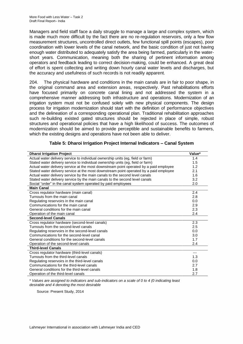
More Food with Less Water – Task 2 53 Draft Final Report– India
Lahmeyer International in association with Lahmeyer India and CED
Managers and field staff face a daily struggle to manage a large and complex system, which is made much more difficult by the fact there are no re-regulation reservoirs, only a few flow measurement structures, uncontrolled direct outlets, few functional spill points (escapes), poor coordination with lower levels of the canal network, and the basic condition of just not having enough water distributed to adequately satisfy the area being farmed, particularly in the water-short years. Communication, meaning both the sharing of pertinent information among operators and feedback leading to correct decision-making, could be enhanced. A great deal of effort is spent collecting and writing down hourly canal water levels and discharges, but the accuracy and usefulness of such records is not readily apparent.
204. The physical hardware and conditions in the main canals are in fair to poor shape, in the original command area and extension areas, respectively. Past rehabilitations efforts have focused primarily on concrete canal lining and not addressed the system in a comprehensive manner addressing both infrastructure and operations. Modernization of an irrigation system must not be confused solely with new physical components. The design process for irrigation modernization should start with the definition of performance objectives and the delineation of a corresponding operational plan. Traditional rehabilitation approaches such re-building existed gated structures should be rejected in place of simple, robust structures and operational policies that have a high likelihood of success. The outcomes of modernization should be aimed to provide perceptible and sustainable benefits to farmers, which the existing designs and operations have not been able to deliver.
Table 5: Dharoi Irrigation Project Internal Indicators – Canal System
Dharoi Irrigation Project Value*
Actual water delivery service to individual ownership units (eg, field or farm) 1.4 Stated water delivery service to individual ownership units (eg, field or farm) 1.5 Actual water delivery service at the most downstream point operated by a paid employee 1.2 Stated water delivery service at the most downstream point operated by a paid employee 2.1 Actual water delivery service by the main canals to the second level canals 1.6 Stated water delivery service by the main canals to the second level canals 3.2 Social “order” in the canal system operated by paid employees 2.0
Main Canal
Cross regulator hardware (main canal) 2.4 Turnouts from the main canal 2.8 Regulating reservoirs in the main canal 0.0 Communications for the main canal 2.9 General conditions for the main canal 2.3 Operation of the main canal 2.4
Second-level Canals
Cross regulator hardware (second-level canals) 2.3 Turnouts from the second-level canals 2.5 Regulating reservoirs in the second-level canals 0.0 Communications for the second-level canal 3.0 General conditions for the second-level canals 1.7 Operation of the second-level canals 2.4
Third-level Canals
Cross regulator hardware (third-level canals) --- Turnouts from the third-level canals 1.3 Regulating reservoirs in the third-level canals 0.0 Communications for the third-level canals 2.7 General conditions for the third-level canals 1.8 Operation of the third-level canals 2.7
* Values are assigned to indicators and sub-indicators on a scale of 0 to 4 (0 indicating least desirable and 4 denoting the most desirable
Source: Present Study, 2014
More Food with Less Water – Task 2 54 Draft Final Report– India
Lahmeyer International in association with Lahmeyer India and CED
2. Benchmarking Indicators
205. The internal indicators are a measure of the flexibility, reliability, equity and measurement of the irrigation water supplies at different levels of the canal system. One can definitely say that the present water delivery service to individual fields in the DIP is not close to the degree that would be required for modern farm irrigation methods. A specialized indicator that ranks the ability of the present water delivery service to support pressurized irrigation system is 0.3 out of a possible 4.0. Significant progress in the control and flexibility of the flows at this level should be a high priority for future modernization efforts. The RAP results indicate that the reliability and equity of farm irrigation deliveries is very poor. The inflexible nature of canal operations provides little flexibility to farmers, even though their very simple field irrigation techniques still require some level flexibility in order to be reasonably efficient.
206. There is a significant difference between quality of water delivery service as described in the project office questions and the actual service as assessed by the RAP indicators. For example, the actual water delivery service by the main canals to branch canals (1.6) compared to the stated service (3.2) is much different. The values given in the office for equity and the control of canal flows were particularly overstated compared to the conditions found in the field. The senior management of the DIP seem to have a relatively good understanding of the operational challenges experienced in the field, so this discrepancy is partly due to the inevitable better presentation of things that occurs at the beginning of an unfamiliar benchmarking exercise. However, it is also a reflection of widespread problems that exist in the system compared to the unintentional focus on areas that receive at least a minimum degree of service. It seems like an unspoken, but real, acceptance exists that tailenders cannot receive the same level of service in terms of reliability and equity in canal water supplies.
207. Another point to bear in mind about the internal indicators shown in Table 5 is that they attempt to reflect the situation more or less across the entire project. Therefore, two points are relevant. The first is that conditions in some parts of the system are significantly worse than the indicators appear to show. Second, the RAP indicators for the DIP are so low that in many cases the distinction between poor and extremely poor ratings is hard to meaningfully distinguish.
208. Ratings for the quality of water delivery service provided by the WRD at different levels of the system are similar (eg, 1.6 at main to secondary canal and 1.4 at the final deliveries to farms/fields). The lack of equity was the main factor in each case. The low service ratings for the main canal(s) highlight the need for an effective water delivery procedure that matches actual irrigation demands in the system. The sub-indicator measuring the degree to which the discharges into the branch/distributary canals were equitable was particularly low (1.0). One sign of the severe inequity in the project is that crop yields during the Rabi season are estimated to be about 25% less in the tailend of the canal system vs. the headend, where water supplies are more readily available.
209. At the level of final deliveries to the individual field outlets, the very low rating for water delivery service (1.4) is due to the lack of flow measurement (0.0), prevalent inequities in the amount of available discharge (1.0), and uncertainties in the rotation schedule (2.0), depending on where an outlet is located within the system.
210. The medium rating for the “social order” indicator (2.0) reflects the small relatively amount of unauthorized outlets (3.0) and outlets where discharges are not within permissible limits (2.0). Vandalism and broken structures is estimated to affect about 5-10% of all infrastructure in the system.
211. The ratings of the indicator for operations at the main canal level is similar as that for cross regulator hardware (2.4 vs. 2.4) based primarily on the fact there is a large elevation

More Food with Less Water – Task 2 55 Draft Final Report– India
Lahmeyer International in association with Lahmeyer India and CED
change across the headworks of branch canals, meaning that fluctuations in water level in the main canal causing variations in the offtaking discharges is moderated somewhat. However, this rating is somewhat deceptive because operations in the upper and lower parts of the canal system are so different. There is no significant difference in the cross regulator hardware ratings between the main canals (2.4) and branch/ distributary canals (2.3).
212. The sluice gates used in the branch and distributary canals are difficult to operate for maintaining constant upstream water levels, and the current level of maintenance is inadequate. However, even though some these gates relatively well-maintained and can move relatively easily, the critical point is that the cross regulators in the system do a poor job of water level control.
213. The general condition of the main canal is relatively good (2.3), which is relatively better than the general conditions present in the branch/distributary (1.7) and minor canals (1.8). These low ratings reflect a general lack of preventative maintenance and insufficient resources in terms of maintenance staff and equipment.
214. The indicators for the offtakes from the main to branch/distributary canals (2.8) was relatively high due to the lack of ‘bottlenecks’ (ie, the outlets can pass their design discharge), and the general level of maintenance of the headworks (2.5).
215. The ratings for communications in the scheme were similar at the main canal, branch canal, and distributary canal level (2.9, 3.0, and 2.7). The sub-indicator ratings the main and branch/distributary canals for the frequency of communications with the next higher level (4.0) was particularly good, indicating field staff are regular contact with their supervisors and other canal operators.
E. Participative Rural Appraisals
216. An extensive PRA program was undertaken in the DIP system to prepare a rapid situation analysis and receive farmers’ feedback for improving irrigated agriculture. The PRAs included preparation of sample area profiles (SAPs) to assess the current status in selected areas. The PRAs were commissioned by the MFLW Task 2 Study through the Development Support Centre (Ahmadabad) working with the MFLW consultants.13
217. Three PRAs were conducted at the head, middle and tail reaches of the RBMC and LBMC command areas; a questionnaire was developed comprising a set of 170 questions to understand the current situation, issues, and probable solutions perceived by the farmers for improving canal system, irrigation and agriculture. In addition, local agriculture retailers and distributors were also interviewed to understand their experiences and identify opportunities to work with farmers and potentials to improve their services. The full report of the PRAs is given in Appendix 7. The summary of findings and major recommendations are as follows:
(i) Only about 20% farmers were generally satisfied in the agricultural sector, the small holdings and returns and lack of support are reasons for dissatisfaction. Women especially reported a high degree of drudgery in agriculture with adverse health implications. The younger generation was generally not interested in agriculture with most of the farming is done by older people and women. New initiatives to improve the returns and the hardship of agriculture were seen to be important. Opening of new initiatives for agriculture support enterprises, especially increased access to mechanization were seen to be important. Moves to contract farming may be the way forward for the longer term.
13
Development Support Centre. September 2014. Participatory Rural Appraisals. Ahmadabad Gujarat

More Food with Less Water – Task 2 56 Draft Final Report– India
Lahmeyer International in association with Lahmeyer India and CED
(ii) The whole canal system up to sub-minor canal was originally built with brick mortar lining, but these have deteriorated over the years, resulting in tailend deprivation and water logging (ie, feast or famine). Farmers wanted government support for upgrading canals including water measurement which they saw as valuable. There was significant interest in piped distribution. The WRD have not responded to farmers requests for rehabilitation.
(iii) In initial years the WRD provided training for the WUAs. Farmers commented the WRD does not have the capacity to support the WUAs and irrigation transfer agreements have lapsed. The WUAs do not have good linkages with other agencies including the Agriculture Department who could potentially provide support. The WUAs had no office space for meetings. Farmers felt their WUA lacked the resources to manage the complex management of surface and groundwater irrigation, agriculture inputs, recharge and a separate parallel organization would be required together with significant external support.
(iv) About 80% of farmers practice conjunctive water use to some extent. Farmers thought that ground and surface water could be better managed using buried pipe and micro irrigation. Involving the tubewell owners in this conjunctive approach is difficult and probably too much for the WUA but not impossible. External support would be required.
(v) Surface water allocation schedules are not followed. Farmers commented that there is no incentive for water saving. Water allocations and charging are on an area basis. Farmers prefer high water using crops as they had higher profitability.
(vi) Micro irrigation using drip, sprinkler is not popular on surface or groundwater due to lack of extension and lack of capacity to absorb the risks. Farmers felt the current subsidy systems were not appropriate for the small farmers.
(vii) Farmers reported almost a complete absence of soil testing services, and as a result, their need to experiment on fertilizer use. Farmers said the local extension workers had inadequate resources to effectively support farmers. The use of new varieties and seed replacement is limited. As a result, yields were lower than the potential. Input supply was inadequate with farmer’s cooperatives not capable of providing an effective input supply. Progress had been made to improve the situation through farmer interest groups (Kisan clubs) working together with farmer produced companies.
(viii) Only very few farmers practiced crop processing as there is no value added. Farmers reported an urgent need to improve crop storage at the village level as the houses were inadequate. Only a few farmers own mechanical equipment.
(ix) Farmers extensively used the credit facilities from the Kisan clubs; about 25% of farmers had defaulted on credit and were now reliant on private money lenders. Generally access to credit was not seen as an issue. Farmers were forced to use crop insurance as part of the credit cooperative and no farmers used it voluntarily. Farmers preferred weather insurance and wanted guidance. Farmers were also interested in market price information. Farmers reported issues of increasing variations in weather patterns
(x) Most farmers had dealings with the private sector but mainly the procurement of inputs. Discussions with the private sector shows there was interest for increased involvement in agriculture. The private sector could offer an increased range of services including demonstrations, farmer meetings, advertising and SMS information. Private companies were interested to work with NGOs and farmers producer companies. There were challenges including lack of storage for products at the lower levels, irregularity of payments, and transportation to remote areas.

More Food with Less Water – Task 2 57 Draft Final Report– India
Lahmeyer International in association with Lahmeyer India and CED
F. Strategic Planning for the DIP
1. Context
218. The previous sections presented detailed assessments of the DIP including responses of the stakeholders (including farmers and operations and extension personnel) to the present situation. The plan for irrigation modernization and management reforms has to fit the complex situation of the DIP, and wherever possible, have incorporated the points raised by the stakeholders. The current irrigation setting is summarized in Table 6.
Table 6: Irrigation Setting at the DIP
Parameter Situation Points
Area The cultivated command area is 95,000 ha of cultivable command area.
The original CCA was increased from 64,000 ha to 95,000 ha. The water for the expanded area was to be sources from increased efficiencies including canal lining as well as savings from reduction in demand for potable water.
The expansion of the irrigation area has put increased pressure on the irrigation resources. Water is allocated across the whole scheme with a result that allocations to each outlet are very low.
Area Currently Irrigated
In an average Rabi season about 85,000 ha or 90% of the CCA is cropped with irrigation. Of the 85,000 ha only 22,000 ha (26%) is provided by surface water, with 74% from groundwater
Groundwater is now dominating the irrigation supply which requires a significant change in irrigation management strategies.
Surface Water There are severe constraints on surface water resources. The Dharoi Reservoir has only fully filled to capacity in two years over the last 37 years. The average release from the reservoir is 263 Mm
3
which drops to 112Mm3 in a 75% dry years
There is very limited potential to increase the surface water resources. The Piyaj supply pipeline pumps water from the Narmada Canal but currently only has potential to contribute about 13 Mm
3/year and the pumping
costs are high.
Groundwater Annual irrigation abstraction from the shallow aquifer in most years exceeds the recharge and there is a heavy reliance on the deep confined aquifer through tubewells. The deep aquifer is not being replenished by recharge from rain or irrigation.
Over abstraction from the deep aquifer is one of the key issues for the DIP. The deep aquifer has high levels of total dissolved salts and there are issues of fluoridation in drinking water
Pumped Irrigation About 30% of CCA 31,000ha is pumped. Farmers pump using a mix of diesel and electric pumps. Farmers are investing in buried pipe distribution to reduce costs.
Efficiency of the pumped irrigation is higher than the gravity irrigation. Further efficiencies and productivity possible by electrifying pumps, use of prepaid meters and micro irrigation.
Agriculture During the dry season farmers are planting a mix of wheat (35%),mustard (13%), castor(19%) . Despite subsidies farmers find pumping costs high.
Participative rural appraisals found a very high level of disillusionment in agriculture. New initiatives are required to improve the viability of agriculture.

More Food with Less Water – Task 2 58 Draft Final Report– India
Lahmeyer International in association with Lahmeyer India and CED
Parameter Situation Points
Water Management
Irrigation is provided by surface water with groundwater providing the balance.
Efforts to measure water allocations to tertiary canals were tried using cut throat flumes but these have largely failed.
The government has introduced some initiatives to control groundwater use including dedicated power lines and restricted access to power. New tubewells are now required to use micro irrigation.
Despite various initiatives surface water delivery remains quite weak (benchmarking scores typically <2 out 4).
The severe limitations on the surface water irrigation and the key role of groundwater together with the need to conserve groundwater requires the development of conjunctive surface and groundwater management systems.
Energy The scheme is a high consumer of energy. In an average year annual energy requirements for surface water pumping are 2.7 GWh and 73 GWh for groundwater.
Management of energy is a key requirement to be incorporated into the scheme planning. Energy must move to a metered rate to conserve power and water.
Operation and Maintenance Costs
Financing of the operation and maintenance needs to be fully evaluated considering surface and groundwater There is no clear directives from the government on how to meet real needs of operation and maintenance funding.
Improving the efficiency and sustainability of irrigation requires increased financial resources. The study has identified the indicative requirements for future funding and clear strategies how these can be met need to be developed. The financial and economic assessments indicate the investments are viable subject to meeting the sustainable financing of the running costs.
Condition of Canal System and Infrastructure
The canal systems are in fair condition with RAP scores of above 2. The RAP found lower scores for the third level canals less than 2. Farmers report that most of the third level canals were previously lined but most has now fully deteriorated.
Full technical assessment of the canal system required. Special attention to repairs to support canal operation is required.
Management Arrangements
Management is directed primarily at the main canal systems.
WUAs report a lack of support.
For the DIP where about 75% of the irrigation is from unsustainable groundwater, a change to conjunctive water resource management is considered an essential requirement for long-term sustainability.
WUAs The WUAs are relatively well-established with RAP scores of 2.4 out of 4.0 due to their widespread coverage and the fact they have some ability to influence real time management of the system.
Farmers indicate that for long-term sustainability the WUAs need to manage all water sources (surface, groundwater tanks etc.). WUA officials considered current capacities were seen to be insufficient to take on this challenging task.

More Food with Less Water – Task 2 59 Draft Final Report– India
Lahmeyer International in association with Lahmeyer India and CED
2. Proposals for Agriculture
219. The cropping pattern in the DIP is fairly constant despite the large variations in surface water availability; groundwater is used to meet the shortfall in surface water supplies.
220. The current and proposed cropping for the DIP is shown in Table 7. It is estimated that the cropping pattern and areas would not significantly change but the increased availability of surface water together with agriculture support would allow an increase in yields. The current yields are shown against the potential which is the value farmers could potentially achieve. Two target yields with the project are shown; the surface yield with surface water irrigation improvements and a higher value for the areas under micro irrigation.
Table 7: Current and Proposed Cropping for the DIP
3. Proposals for Surface Water Management
a. Objectives
221. The objectives for the modernization of the DIP is to (i) improve the WUE and POW of irrigated agriculture; and (ii) to reduce the use of groundwater to sustainable levels
b. Water Balance
222. A simple water balance for the DIP has been prepared to help understand the surface and groundwater balance for different levels of irrigation release from the Dharoi Dam as shown in Table 8. The crop water requirements for the cropping pattern have been assessed at 530 mm. Current efficiency based on data of the area irrigated by surface water, overall water efficiency is estimated to be 44%.
223. From the table, under current conditions the maximum irrigable area by surface water in a 50% dry year (DY) is 22,000 ha. The water balance examines three development scenarios: (i) current; (ii) investments in surface water and improved management; and (iii) investments in surface water and 27% micro irrigation. The water balance shows continued dependency on groundwater under all conditions and scenarios.
224. Investment in surface water systems does, however, allow some reduction in the use
Period Current % Future % Current Potential
Target
Surface
Target
Micro
Irrigation
1 Wheat Nov-Mar Rabi 33,037 35% 33,037 35% 3.0 6.0 3.8 5.0
2 Mustard Nov-Jan Rabi 11,994 13% 11,994 13% 1.2 2.2 1.5 2.0
3 Castor Jul-Jan Rabi/Kharif 17,818 19% 17,818 19% 3.5 7.0 5.0 6.0
4 Cotton Jul-Jan Rabi/Kharif 4,340 5% 4,340 5% 2.0 5.0 3.0 4.0
5 Fennel Jul-Jan Rabi/Kharif 1,605 2% 1,605 2% 1.8 2.3 2.0 2.3
6 Millet Jul-Oct Kharif 20,000 21% 20,000 21% 1.3 1.8 1.5 1.6
7 Sesame Jul-Oct Kharif 7,000 7% 7,000 7% 0.4 0.8 0.5 0.6
8 Vegatable (rabi) Nov-Feb Rabi 16,379 17% 16,379 17% 24.0 50.0 30.0 40.0
9 Vegatable (Kharif) Jul-Oct Kharif 10,000 11% 10,000 11% 20.0 35.0 25.0 30.0
10 Fodder Jul-Oct Kharif 5,877 6% 5,877 6%
Crop Area During Rabi 85,173 89% 85,173 89%
Crop Area During Kharif 66,640 70% 66,640 70%
Total/intensity 128,050 135% 128,050 135%
Yield (T/ha)
Nr Seasons & Crops Season
Area (ha)

More Food with Less Water – Task 2 60 Draft Final Report– India
Lahmeyer International in association with Lahmeyer India and CED
of groundwater; currently for an average year groundwater area is 73,000 ha (with potential to reduce to 67,000 ha with modernization investments and micro irrigation. The impact of better delivery efficiencies is quite limited due to the low levels of surface water availability.
Table 8: Preliminary Water Balance DIP
c. Conjunctive Surface and Groundwater Management
225. Currently the irrigation in the DIP is by default a conjunctive surface and groundwater system with the groundwater meeting the major shortfall in the surface water supply. The conjunctive water balance is complex and currently there is only a limited data and understanding. The concept of the surface and groundwater systems is shown in Figure 6.
(i) Groundwater is currently abstracted from the surface and deep aquifer to meet the about of the 80% of the irrigation requirements.
(ii) Farmers pump from the shallow aquifer but more recently this has come insufficient and over recent years there has been an increasing use of the deep aquifer.
(iii) There uncertain data on the number of wells and the area irrigated from the deep aquifer; there is only limited recharge to the deep aquifer, which has issues of salinity problems that is causing problems to farmers, there are long-term risks of salinization and degradation with declines in land productivity.
(iv) The government is supporting various recharge programs aimed at improving the recharge of the shallow aquifer; surface water irrigation is a major contributor to the recharge of the shallow aquifer however these are insufficient to reduce the deep water abstractions.
(v) Energy requirements for pumping are extremely high; the current lump sum charging system does not support conservation of energy or water.
Water Case 10% DY 25% DY 50% DY 75% DY 90% DY
Mean Irrigation Release from Dam (Mm3) 490 409 263 152 109
Annual Rainfall 1455 845 372 266 145
Surface Water Availability (mm over the CCA)
1. Current 227 190 122 70 50
2. Surface Water Improvements 263 220 141 81 58
3. Surface water improvements plus 25,000ha piped and micro 289 241 155 89 64
Area Irrigable by Surface Water (Ha)
1. Current 41,000 34,000 22,000 13,000 9,000
2. Surface Water Improvements 47,000 39,000 25,000 15,000 11,000
3. Surface water improvements plus 5000ha piped and micro 52,000 43,000 28,000 16,000 12,000
Area Irrigated by GroundWater (ha)
1. Current 54,000 61,000 73,000 82,000 86,000
2. Surface Water Improvements 48,000 56,000 70,000 80,000 84,000
3. Surface water improvements plus 25000ha piped and micro 43,000 52,000 67,000 79,000 83,000
Note: 1 current efficiency 44% , surface water improvements 51%, surface water improvements plus 25000ha piped and
micro irrigation 56%
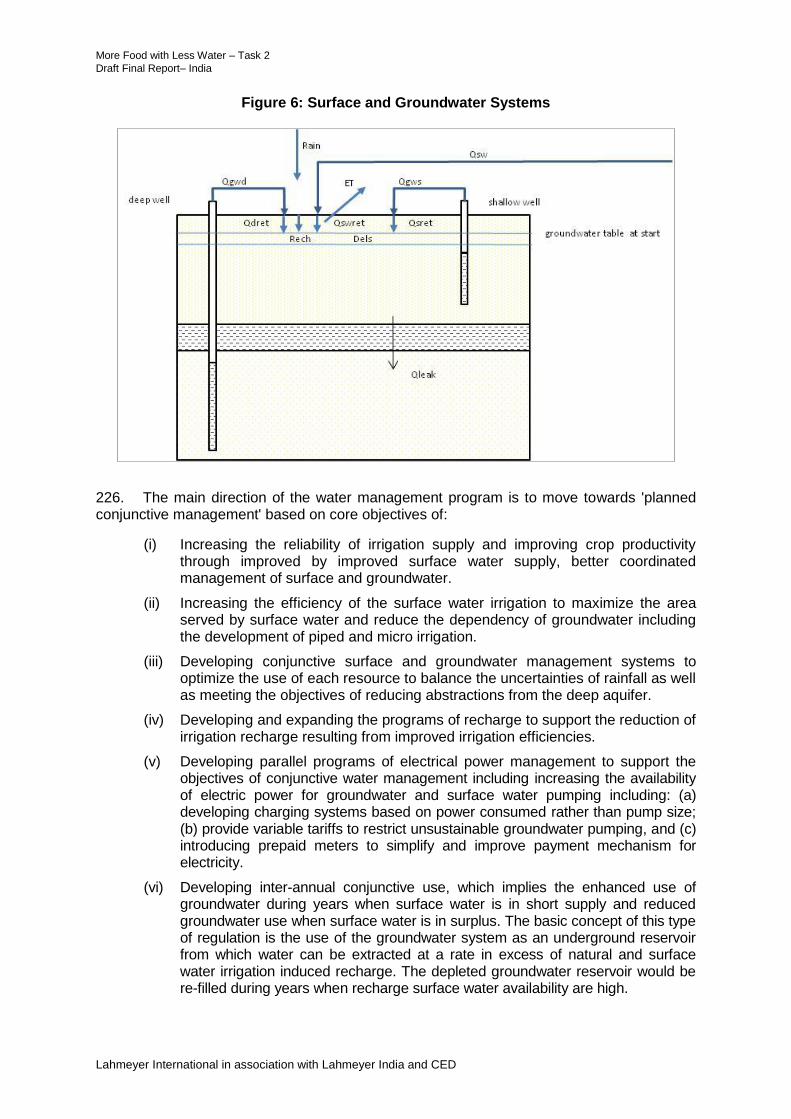
More Food with Less Water – Task 2 61 Draft Final Report– India
Lahmeyer International in association with Lahmeyer India and CED
Figure 6: Surface and Groundwater Systems
226. The main direction of the water management program is to move towards 'planned conjunctive management' based on core objectives of:
(i) Increasing the reliability of irrigation supply and improving crop productivity through improved by improved surface water supply, better coordinated management of surface and groundwater.
(ii) Increasing the efficiency of the surface water irrigation to maximize the area served by surface water and reduce the dependency of groundwater including the development of piped and micro irrigation.
(iii) Developing conjunctive surface and groundwater management systems to optimize the use of each resource to balance the uncertainties of rainfall as well as meeting the objectives of reducing abstractions from the deep aquifer.
(iv) Developing and expanding the programs of recharge to support the reduction of irrigation recharge resulting from improved irrigation efficiencies.
(v) Developing parallel programs of electrical power management to support the objectives of conjunctive water management including increasing the availability of electric power for groundwater and surface water pumping including: (a) developing charging systems based on power consumed rather than pump size; (b) provide variable tariffs to restrict unsustainable groundwater pumping, and (c) introducing prepaid meters to simplify and improve payment mechanism for electricity.
(vi) Developing inter-annual conjunctive use, which implies the enhanced use of groundwater during years when surface water is in short supply and reduced groundwater use when surface water is in surplus. The basic concept of this type of regulation is the use of the groundwater system as an underground reservoir from which water can be extracted at a rate in excess of natural and surface water irrigation induced recharge. The depleted groundwater reservoir would be re-filled during years when recharge surface water availability are high.

More Food with Less Water – Task 2 62 Draft Final Report– India
Lahmeyer International in association with Lahmeyer India and CED
(vii) Improving water availability through piped and micro irrigation to be supplied by combined surface and groundwater water sources.
(viii) Developing institutional models to integrate surface and groundwater service providers through service agreements. Private sector tubewells to be contracted to provide groundwater.
4. Proposals for Groundwater Management
227. Groundwater management is heading for a crisis in the DIP and needs improved understanding and urgent attention. Groundwater is found to be superior source of irrigation compared to surface water primarily due to the high levels of insecurity of the surface water. Despite the additional costs of pumping groundwater is associated with better yields, input use and profitability in the Dharoi scheme due to the better control over availability.
228. There is an urgent need for ensuring discipline on groundwater use to avoid the deepening agricultural crisis. Some policies being followed by the Gujarat Government in fact encourage wasteful use of water. As the National Commission on Farmers (NCF) has pointed out, having access to cheap power use almost doubles the amount of water per unit of crop compared to farmers using diesel pump sets. Continued provision of free power by some states, encourages excessive use of groundwater.
229. An important objective of the program for the Dharoi irrigation project is to support the long term sustainable management of the groundwater. The impacts of groundwater abstraction from both the deep and shallow aquifers is dependent on a number of parameters, which define natural recharge and irrigation return flow to the shallow aquifer, and also the connectivity of the deep and shallow aquifer.
230. To address the impact of large scale groundwater abstraction and the conjunctive use of surface water and groundwater in detail, there would be need to undertake an integrated surface water and groundwater study, likely involving modelling.
231. The proposed strategy for groundwater management for the DIP is through the development of advanced irrigation systems fitted with piped distribution and micro irrigation supplied conjunctively by both surface and groundwater sources.
(i) Advanced irrigation systems would be based on 100 ha blocks and would include full buried pipe distribution and micro irrigation (sprinkler and drip)
(ii) Surface water would be abstracted from the canals and would be fed into storage tanks located near the offtake. (An option proposed by farmers is to feed the water into a large diameter open well which would support some recharge.)
(iii) An electric low lift pump would pump water from the tank into the buried pipe distribution network which would feed to hydrants serving 5-ha blocks.
(iv) Farmers would irrigate from the hydrants using micro irrigation systems.
(v) Private tubewell operators would act as service providers and would be contracted to supply water to the distribution network at an agreed tariff.
(vi) Farmers would pay for water using a prepaid meter at the low lift pump at the canal outlet. The pump operator would be able to use the surface water, or source water groundwater wells if the surface water was inadequate.
(vii) For each 100-ha block a quota allocation of surface water per season would be provided depending on the availability in the reservoir at the start of the season.
(viii) A quota for shallow and deep groundwater abstraction would also be set for the 100-ha block and for each pump inside the unit. The quota would be set to

More Food with Less Water – Task 2 63 Draft Final Report– India
Lahmeyer International in association with Lahmeyer India and CED
balance the availability of the surface water and the estimated sustainable groundwater abstraction. During wet years the groundwater quota would decrease and during dry years increase to offset the shortfall of surface water.
(ix) The electric tariff per KWh consumed would be set at an appropriate tariff up to the quota of each well. Above the quotas the tariff would increase significantly.
232. Over and above the balancing of surface and groundwater described above special arrangements are required for areas of poor quality groundwater as shown in Table 9.
Table 9: Management of Groundwater Quality
Groundwater Class
Depth to Groundwater (m)
TDS (mg/l)
Strategy
Shallow good groundwater
10-20 <1500 Maintain abstractions within groundwater quotas.
Deep good groundwater
>20 <1500 Restrict use unless shortage of surface and shallow aquifer
Shallow bad groundwater areas
10-20 >1500 Provide increased surface water allocation. Poor quality groundwater can be mixed with surface water.
Deep bad groundwater
>20 >1500 Provide priority for surface water
233. For the current study a simple and preliminary water balance approach was adopted for a combined shallow and deep aquifer system, with the two aquifers separated by a low permeability clay layer. An outline the schematic of the water balance approach is given in Figure 7. The water balance uses a lumped parameter approach with time steps of one year. The water balance is simple and based on numerous assumptions, some of which cannot yet be fully substantiated from available information. The approach is, however, suitable to obtain insight into the response of the aquifer system to planned scenarios related to the conjunctive use of surface water and groundwater. A number of assumptions had to be adopted in the water balance model:
(i) Within the water balance domain, both groundwater and surface water irrigation facilities are evenly distributed. All water balance components are expressed as mm/year over the gross area.
(ii) The ratio of irrigated to total area is taken as 0.56 (iii) Recharge is in the form of natural recharge taken as a percentage (20%) of annual
rainfall, return flow from irrigation, based on irrigation efficiency and the percentage of irrigation ‘loss’ contributing to recharge. Efficiencies can be different for irrigation using groundwater and surface water and are obviously related to the irrigation techniques.
(iv) The water balance uses a simulation period of 37 years with rainfall and surface water availability expressed as in Table 10.For the 37 year period it is assumed that rainfall and surface water availability are randomly distributed.
(v) The hydraulic connection between the shallow and deep aquifer is uncertain and the model assumes a range of scenarios where groundwater abstraction from the deep aquifer is balanced by downward leakage from the shallow aquifer by varying degrees, including zero, 50 and 100%.

More Food with Less Water – Task 2 64 Draft Final Report– India
Lahmeyer International in association with Lahmeyer India and CED
Table 10: Surface Water Availability and Rainfall for a 37 Year Period
Occurrence (years) 2 16 10 6 3
Surface water mm/year 500 383 208 130 110
Rainfall mm/year 1455 845 372 266 145
234. The scenarios considered are grouped as follows:
(i) Current situation with low surface water irrigation efficiency (35%) and moderate groundwater irrigation efficiency (60%)
(ii) Some improvement in surface water irrigation efficiency (50%) and no change in groundwater irrigation efficiency
(iii) Significant improvements in irrigation efficiency, 70% for surface water and 80% for groundwater using partial piped distribution and micro irrigation.
235. For all three scenarios, various ratios of groundwater from deep aquifer to total groundwater abstraction are assessed. There is also variation in the ratio of groundwater taken from the deep aquifer balanced by downward leakage from the shallow aquifer. The extreme cases include all groundwater abstracted from the deep aquifer balanced by downward leakage from the shallow aquifer (scenarios 1, 4 and 7), while the other extreme assumes that none of the groundwater abstracted from the deep aquifer is balanced by downward leakage from the shallow aquifer (scenarios 3, 6 and 9).
236. A total of 27 simulation runs were made. For each simulation the derived water balance components are listed and the total change in storage expressed as a decline or rise in the groundwater table in the shallow aquifer. For long-term sustainability to be achieved, the change in groundwater level over the 37 years should be small.
237. The simulations are summarized in Table 11 Table 11for changes in groundwater level in the shallow aquifer of less than or equal to 8.5m. The ones that achieve sustainability are highlighted in grey.
238. The water balance assessment provides insight into the feasibility of conjunctive use of surface water and groundwater and the following conclusions aim to highlight the main findings.
(i) If the connection between the deep and shallow aquifer is good, then all deep groundwater abstraction will be balanced by leakage from the shallow aquifer. In this situation it is irrelevant what the ratio of abstraction from shallow and deep aquifer is. For the assumed high efficiency scenarios, sustainable conditions can be achieved.
(ii) When the deep aquifer is isolated from the shallow aquifer, abstraction from the deep aquifer used for irrigation will result in a significant rise in the groundwater level in the shallow aquifer. If this condition exists, the only way to obtain a sustainable situation is to use most groundwater from the shallow aquifer.
(iii) Uncertainties relate mainly to the connection between the shallow and deep aquifers. If poorly connected, groundwater abstraction from the deep aquifer will result in significant groundwater table rise in the shallow aquifer. If the connection is good, no such problem arises. The fact that groundwater levels have been rising in the shallow aquifer over recent years in areas where surface water irrigation water has been available, indicates that the connection between the two aquifers is poor to possibly moderate. If there is a poor connection, then abstraction from the shallow aquifer should be considered, although the uncertainty is in the ability of this aquifer to sustain reasonably large abstraction. Given the moderate hydrogeological characteristics of the shallow aquifer, one would probably opt for dug wells.

More Food with Less Water – Task 2 65 Draft Final Report– India
Lahmeyer International in association with Lahmeyer India and CED
239. Uncertainties may be addressed during project implementation and groundwater modelling and targeted monitoring would allow uncertainties to be reduced.
Figure 7: Schematic of Surface Ground Water Balance Model
Shallow aquifer
Confining clay layer
Deep aquifer
QsretQdret
Qleak
deep well shallow well
Qgwd
Qsw
groundwater table at start and end of year
Qswret
Rain
Rech
ET Qgws
Dels
Description of water balance components
Rain Annual rain
ET Net irrigation demand
Qsw Gross irrigation supply
Qgw d Gross abstraction from deep aquifer used for irrigation
Qgw s Gross abstraction from shallow aquifer used for irrigation
Qdret Return flow to groundw ater table from deep groundw ater application
Qsret Return flow to groundw ater table from shallow groundw ater application
Qsw ret Return flow from surface w ater application
Rech Recharge due to monsoon rainfall
Dels Storage change in shallow aquifer
Qleak Dow nw ard leakage from shallow to deep aquifer

More Food with Less Water – Task 2 66 Draft Final Report– India
Lahmeyer International in association with Lahmeyer India and CED
Table 11: Summary of Conjunctive Surface and Ground Water Balances
5. Proposals for Energy Management
240. Pumped irrigation water from surface water and groundwater, is one of the main energy users in Gujarat. Current energy for groundwater pumping is around 73 GWh. Increasing efficiencies and agricultural productivity offers the potential to reduce energy use, but some “water saving technologies” such as micro irrigation can also result in increased energy use, although these can be offset to some extent by reduced groundwater pumping.
241. Rising costs for energy is a critical consideration and the role of energy subsidies is critical. The current system of a flat-fee for energy is not sustainable and does nothing to conserve energy or water. The short term objectives of providing low-cost groundwater irrigation must be balanced with the irreversible damage to the aquifer and the land as well as the heavy costs of supplying power.
242. The proposed energy management for the DIP consist of the following:
(i) Changing of diesel pumps to efficient electric pumps
(ii) Changing the current flat fee for all electric power to an energy consumed fee
(iii) Surface and groundwater irrigation pump units to be fitted with pre-paid meters.
(iv) Energy tariffs to be applied to meet the criteria of (a) affordability by farmers, (b) to cover the costs of power as well as the costs of service delivery of groundwater or surface water, and (c) meet the needs of water conservation
Recharge
from
rainfall
Irrigation
return
from
surface
water
Ground
water
pumped
Ground
water
pumped
deep
ground
water
pumped
shallow
GW irr
return
Leakage
to deep
aquifer
1a 120 51 361 361 0 144 361 -8.5
1b 120 51 361 180 180 144 180 -8.5
1c 120 51 361 0 361 144 0 -8.5
2b50-50 split between shallow and deep aquifer
abstraction120 51 361 180 180 144 90 8.2
2c 120 51 361 0 361 144 0 -8.5
3c 120 51 361 0 361 144 0 -8.5
4a 120 39 322 322 0 129 322 -6.3
4b 120 39 322 161 161 129 161 -6.3
4c 120 39 322 0 322 129 0 -6.3
5b50-50 split between shallow and deep aquifer
abstraction120 39 322 161 161 129 80 8.6
5c 120 39 322 0 322 129 0 -6.3
6c 120 39 322 0 322 129 0 -6.3
7a 120 37 202 202 0 40 202-0.8
7b 120 37 202 101 101 40 101-0.8
7c 120 37 202 0 202 40 0-0.8
8b50-50 split between shallow and deep aquifer
abstraction120 37 202 101 101 40 51
8.5
8c 120 37 202 0 202 40 0-0.8
9c 120 37 202 0 202 40 0-1
Note A negative value in the last column indicates a drop in groundwater level
Cumulative
change in
groundwat
er level(m)
All groundwater abstraction balanced by leakage
from the shallow aquifer, implies that the ratio of
abstraction from the deep aquifer to total
abstraction is of no relevance
All values in mm/year/unit gross area
Scenario
Surface
water
upgrading
with
conjunctive
management
and micro
irrigation
Surface
water
upgrading
Current
All groundwater abstraction balanced by leakage
from the shallow aquifer, implies that the ratio of
abstraction from the deep aquifer to total
abstraction is of no relevance
All groundwater abstraction balanced by leakage
from the shallow aquifer, implies that the ratio of
abstraction from the deep aquifer to total
abstraction is of no relevance
100% of groundwater from shallow aquifer (only
feasible if aquifer is sufficiently productive)
100% of groundwater from shallow aquifer (only
feasible if aquifer is sufficiently productive)
100% of groundwater from shallow aquifer (only
feasible if aquifer is sufficiently productive)

More Food with Less Water – Task 2 67 Draft Final Report– India
Lahmeyer International in association with Lahmeyer India and CED
including lower costs for sustainable water (surface water or groundwater within the quota levels) and higher costs for unsustainable water (groundwater above the quota levels).
243. Prepaid meters have been used around the world for many years for domestic electricity and water supply, and more recently, for irrigation. The prepaid meter like the prepaid phone card requires the user to pay in advance and avoids the long and costly process of meter readings, issuing bills and collecting payment. For the communal water use such as an irrigation pump the use of prepaid cards allows the farmer to buy credit on a prepaid card. The card is inserted into the prepaid meter and the amount payable deducted from the credit on the card. The prepaid meters are programmable to allow different tariffs according to the water source (surface, deep or shallow groundwater and quota levels).
G. Plan for Modernization of DIP
1. Introduction
244. The DIP urgently requires investment in irrigation modernization. The scheme is in a low rainfall area and suffers from major fluctuations in surface water availability; surface water is exceedingly short and in an average year currently only provides irrigation for about 24% of the area. Groundwater from a shallow and deep aquifer provides the balance of the supply. The shallow aquifer despite significant recharge from irrigation is insufficient and water is pumped from the deep aquifer, which is facing problems of overexploitation and high levels of salinity. The objective of the modernization plan is to (i) increase the crop production from the irrigation systems; (ii) to develop sustainable use of surface and groundwater through conjunctive water management.
245. The long-term water management strategy in the DIP requires a move towards integrated management of the surface and groundwater resources; although this is currently occurring by default there would be benefits if the three water main water sources; surface water, shallow aquifer and deep aquifer, were managed conjunctively with the objective of optimizing the surface and groundwater resources, including the establishment of inter-annual water management. This would reduce groundwater use during good rainfall years and increase the abstractions from the aquifer during dry years. Through this approach the large variations in surface water can be buffered through the significant storage in the shallow aquifer. Conjunctive surface and groundwater management requires a major change in the water management operations involving surface water and groundwater users working together.
246. Two investment options for the DIP are presented and assessed:
(i) Option 1: Upgrading and modernization of the surface water system, including the development of improved surface water management: Option 1 would incorporate necessary upgrades to control and measurement infrastructure, construction of essential new facilities for re-regulation of canal flows, repairs to existing structures, targeted canal lining, and the introduction of decision support systems and remote monitoring networks. Strengthening of institutions would be undertaken to better manage surface water resources, including comprehensive water management planning that governs all aspects of water deliveries, scheduled maintenance, and cost recovery (payment amounts and fee collection).
(ii) Option 2: Upgrading and modernization of surface water system together
with conjunctive groundwater management, micro-irrigation and agriculture support: Option 2 would incorporate the proposals for surface water modernization as proposed in Option 1 and in addition would include

More Food with Less Water – Task 2 68 Draft Final Report– India
Lahmeyer International in association with Lahmeyer India and CED
25,000 ha of micro-irrigation supplied by conjunctive surface and groundwater. Surface water management would be extended to integrated management of surface water, groundwater and power. Agriculture support initiatives would be developed through promotion of commercial initiatives including increased involvement of the private sector. The outcome would be the establishment of long-term and sustainable institutional arrangements with capacities and resources for holistic management of surface and groundwater resources and energy.
2. Investment Plan
247. The DIP investment plan is presented in Table 12. Option 1 is directed at modernization of the canal systems and the introduction of improved management. Under Option 1 there would only be limited support for agriculture and meeting the long-term issues of sustainable groundwater management. Option 1 will provide short to medium term benefits; however, some of the fundamental issues of groundwater sustainability will remain unresolved. Option 2 is a more expensive and complex project; it is however designed to address some of the longer term issues of sustainability and move the DIP towards a high level of productivity and sustainability for the medium to long-term.
3. Operation and Maintenance Costs
248. The estimated operation and maintenance costs are given in Table 13 below
4. Upgrading of the Canal Systems
249. Upgrading of the canal systems in both command areas is a core requirement for both options. Surface water is extremely limited and maximizing the efficiency of the canal and water allocation systems is a key requirement. The investment requirements of the upgrading work are summarized in Table 14
5. Pipe Distribution and Micro Irrigation
250. For Option 2, additional investment in a buried pipe distribution network(s) and micro irrigation is proposed. Initially it is proposed to develop an initial 25,000 ha with a priority to focus on the current area of pumped irrigation and areas of poor groundwater.
251. The scope of the investment would include:
(i) The systems would serve about 100-ha blocks
(ii) Low-level storage tank fed from the canal offtake
(iii) PVC buried pipe to supply water to 5-ha blocks
(iv) Electric low-lift pump to pump water into the system
(v) Inter-connection of tubewells to supply the water to the pipe network
(vi) Micro irrigation systems (sprinkler or drip) would be connected to the 5-ha outlet hydrants
(vii) Payment for water by a prepaid meter at the surface water outlet. The operator would have option to switch on surface and or tubewell pumps according to surface water availability.
252. The consultations through the PRA have identified the interest by farmers in micro irrigation but there is concern by farmers to invest (even with the subsidies) due to the lack of knowledge of the systems and the unknown risks of these micro irrigation.

More Food with Less Water – Task 2 69 Draft Final Report– India
Lahmeyer International in association with Lahmeyer India and CED
Table 12: Dharoi Investment Plan
Nr Item $ million Rs Crore % $ Rs Crore %
A Right Bank - -
1 Main Canal 0.6 3.6 1 0.6 3.6 1
2 Branch Canals 1.3 7.8 2 1.3 7.8 2
3 Distributory Canals 1.8 10.7 2 1.8 10.7 2
4 Regulation Reseroirs 10.0 60.1 14 10.0 60.1 14
5 Minors and Sub Minors 8.4 50.2 11 8.4 50.2 11
6 Lining 38.3 229.5 52 38.3 229.5 52
B Left Bank - - - -
1 Main Canal 0.4 2.6 1 0.4 2.6 1
2 Branch Canals 0.3 1.8 0 0.3 1.8 0
3 Distributory Canals 2.2 13.0 3 2.2 13.0 3
4 Minors and Sub Minors 3.1 18.4 4 3.1 18.4 4
5 Lining 6.8 40.6 9 6.8 40.6 9
C 1 Scada 0.5 3.0 1 0.5 3.0 1
Sub Total 73.6 441.5 100 73.6 441.5 100
II PIPE DISTRIBUTION AND MICRO IRRIGATION
1 Buried pipe distribution 25,000ha 17.5 105.0 52
2 Upgrading of electrical distribution 25,000ha 5.0 30.0 15
3 Micro Irrigation 25,000ha 11.3 67.5 33
Sub Total 33.8 202.5 100
III AGRICULTURE SUPPORT INITIATIVES
1 Crop Storage and Marketing Systems 4.0 24 33
2 Support for Farmer Enterprises 3.0 18 25
3 Other Agricultural Support Intitatives 3.00 18.0 100 5.0 30 42
Sub Total 3.0 18.0 100 12.0 72.0 100
IV 2.0 12.0 100
V 0.5 3.0 1.0 6.0
VI CONSULTANCY AND MANAGEMENT SUPPORT - -
1 Planning, feasibility studies and design 2.2 13 19 3.2 19 19
2 Supervision of construction 3.7 22 31 5.4 32 31
3Establishment of New Management
Organization 5.9 35 50 8.6 52 50
Sub Total 11.8 70.6 50 17.2 103 100
VII
18.3 110 100 19.0 114 100
VIII 0.6 3.6 100 0.6 3.6 100
TOTAL INVESTMENT 107.7 646.3 159.1 954.4
CONTINGENCIES 15% 16.2 96.9 23.9 143.2
TOTAL INVESTMENT 123.9 743.3 - 182.9 1,097.6
Cost per ha ($/ha) 1,301 1,922
LAND ACQUISITION
I. UPGRADING OF SURFACE WATER CANAL
SYSTEMS
OM BUDGET SUPPORT DURING
IMPLEMENTATION PERIOD
Modernization of the canal
systems, conjunctive
management and 25,000ha
micro irrigation
Modernization of the canal
systems and improved
management
TRAINING AND AWARENESS
PILOT RECHARGE AND GROUNDWATER
MANAGEMENT INITIATIVES
OPTION 1 OPTION 2
Investment Components

More Food with Less Water – Task 2 70 Draft Final Report– India
Lahmeyer International in association with Lahmeyer India and CED
Table 13: DIP Estimated Costs for Operation and Maintenance
.
Component
Total ($
million)
Cost/ha
($)
Total ($
million)
Cost/ha
($)
Total ($
million)
Cost/ha
($)
Surface WaterPersonnel costs 1.5 16 1.9 20 2.0 21 Canal Maintenance 2.0 21 2.6 27 2.6 27 Other Misc OM Costs 2.8 29 3.6 38 3.6 38 Total Surface Water 6.3 66 8.2 86 8.2 86
Farmer SystemsGroundwater 10.1 138 9.7 138 7.9 117.0 Pumped Surface Water 0.4 53 0.4 53 0.3 53.0 Micro Irrigation 2.6 104 Total Farmers Systems 10.5 111 10.1 106 10.8 114
Total OM Costs 16.8 177 18.3 192 19.0 200
Areas of Irrigation1.Surface Water Irrigation 22,000 25,000 28,000 Gravity Surface Water Irrigation 18,000 27,000 40,000 Pumped Surface Water Irrigation 7,300 8,300 5,000 2. Groundwater Irrigation 73,000 70,000 67,000 3. Pipe distribution and micro irrg. 25,000
Notes
Ha
Current Option 1 Option 2
Modernization of
canal systems and
improved
management
Modernization of the
canal systems,
conjunctive
management and
25,000ha micro
irrigation
6. Micro irrigation based on 90% sprinkler and 10% drip
7. Improved management of canal systems based on 30% increase on current OM expenditure
1. Groundwater costs based on average pumping head 25m (shallow and deep aquifer), electricity
Rs7/kw-h ($116/mw-hr). Pump efficiency 0.6
2. Pumping costs are based on actual costs of pumping based on head and volume pumped. Currently
farmers pay a fixed cost per hp of pump
3. Surface water efficiency 43%, efficiency increases by 15% to 51% after modernization
4. Efficiency of under micro irrgation 70%, overall scheme efficiency with 25000ha micro irrigation 56%,
5. Groundwater efficiency 60% with micro irrigation gw efficiency increases to 80%

More Food with Less Water – Task 2 71 Draft Final Report– India
Lahmeyer International in association with Lahmeyer India and CED
Table 14: Summary of Surface Water Upgrading Works ($)
6. Agriculture Support
253. From the PRAs it has been found that farmers lack sufficient information and support to achieve the full potentials of irrigated agriculture. The Department of Agriculture Extension staff are under-resourced with insufficient capacities support uptake of modern and high productivity irrigated agriculture. The project proposals for irrigation modernization require support from parallel investments in the agricultural systems, and therefore it is proposed that significant funding would be allocated towards intensive, professionalized agricultural support services in both the schemes. The current extension staff are under-resourced, so it is proposed that agricultural support be provided as a part of the investment in irrigation modernization.
254. This parallel investment in agriculture support will facilitate increased crop yields and better financial returns, including a faster uptake of new agricultural technologies, such as micro-irrigation. To achieve long-term sustainability it is proposed that the agriculture support program is based on commercial activities through PPP contracts with seed money for startup costs supported by the investment program. Activities would be designed to ensure financial viability which allows the programs to grow, self-financing and sustainable. The intention is to offer a nucleus of localized self-financing support services, either directly or by interacting and engaging with existing government agriculture programs, commercial agriculture companies, NGOs and farmer-level producer organizations. It is envisaged that the agriculture support initiatives would be a mix of those by a specialized central-level unit together with decentralized initiatives. Initiatives could include (i) support for crop storage and marketing systems to allow farmers improved opportunities to get improved returns for their crops, (ii) improved and more timely supply of inputs at fair market prices, (iii) higher quality and more availability of training and extension services, and (iv) contract farming to open up new technologies, farming and marketing systems.
255. The sustainability of the agricultural support program will be achieved through the establishment of commercial activities with startup cost supported by the investment but would be self-financing after the end of the project period. During the initial 5 years project financial support can be used to fund the agriculture support activities; the program must however create revenue that can be put aside into an agriculture support fund in an escrow
Location
Mechanical
and
Electrical Civil Works Total %
Right Bank
Main Canal 12,000 585,000 598,000 1
Branch Canals 12,000 1,290,000 1,302,000 2
Distributory Canals 11,000 1,773,000 1,784,000 2
Regulation Reseroirs 1,300,000 8,724,000 10,024,000 14
Minors and Sub Minors - 8,370,000 8,370,000 11
Lining - 38,250,000 38,250,000 52
Left Bank - - -
Main Canal 83,000 348,000 432,000 1
Branch Canals 3,000 297,000 301,000 0
Distributory Canals 36,000 2,139,000 2,174,000 3
Minors and Sub Minors - 3,070,000 3,070,000 4
Lining - 6,770,000 6,770,000 9
SCADA 525,000 - 525,000 1
- - -
Total 1,984,000 71,617,000 73,600,000 100

More Food with Less Water – Task 2 72 Draft Final Report– India
Lahmeyer International in association with Lahmeyer India and CED
bank account. At the end of the 6 year project period the support fund would be used as capital to continue to the agriculture support program on a long-term sustainable basis
7. Pilot Recharge and Groundwater Management Activities
256. Increasing WUE through surface water investments and management will result in reduced recharge of the shallow groundwater. Investment support for pilot recharge and groundwater management is proposed including:
(i) Development of community-led recharge pilot recharge programs
(ii) Construction of energy and water efficient tubewells that can complement existing private sector wells, which can act as models for water and power efficient wells.
(iii) Pilot investments to support the inter-annual management of groundwater.
(iv) Other pilot recharge pilots including improving the efficiencies of the recharge from the Narmada or the spreading canal.
8. Training and Awareness
257. One of the main issues identified for the poor performance of the DIP has been the poor understanding of the needs of the different parties and stakeholder groups. Training and awareness is seen as a critical requirement to ensure all the stakeholders fully understand the project objectives including the new management and financing arrangements. Engagement and support for awareness with the key stakeholders including the local politicians will be critical. The Stakeholder Engagement and Communication Strategy (SECS) will be designed to significantly increase stakeholder and community awareness of the project strategy, proposals activities and outputs in order to improve stakeholder engagement and to develop greater community support for the project proposals and the decision making process. The SECS program would develop new approaches including use of technology and social media to improve the outreach of SECS.
258. Training of the new responsibilities of the WUA in groundwater management will be a major requirement under Option 2.
259. The SECS is proposed to be implemented in two stages comprising (i) during the planning and detailed design for the DIP, and (ii) during the implementation phase. To ensure long-term sustainability of the training and awareness potentials for self-financing would be explored including sponsorships, advertising, basic charging for training.
9. Institutional and Management Framework
260. The institutional and management framework would follow the proposals given in Section IV above. The long-term management framework is directed at Option 2 which includes conjunctive surface and groundwater management and development of micro irrigation
261. For Option 1 the focus is primarily on the surface water irrigation however a significant upgrade of the level of irrigation management will be required to meet the project requirements.
10. Consultancy and Management Support
262. The investment will need to supported by consultancy including:

More Food with Less Water – Task 2 73 Draft Final Report– India
Lahmeyer International in association with Lahmeyer India and CED
(i) Planning feasibility and design over 2 years would include detailed groundwater surface and groundwater modeling and GIS mapping
(ii) Supervision of construction
(iii) Establishment of the new management organization over 5 years. This would be in the form of a management contract with the objectives of establishing a sustainable and effective the long-term project management organization.
H. Economic and Financial Analysis
263. A financial and economic analysis of some of the different options for the Dharoi project has been completed with the objective of preparing a preliminary assessment of the viabilities of different development strategies.
264. The economic analysis refers first quarter of 2014 constant prices. The exchange rate used is Rs60 = $1 and discount rate is 12%. The project life is 20 years. Economic prices exclude taxes. A standard conversion factor of 0.97 has been used to adjust financial prices. A shadow wage rate factor of 0.80 has been applied to unskilled wage rates to reflect the relative abundance of unskilled labour, although in some locations at some times of year this may under-value unskilled labour due to the seasonal migration of labour for work in other parts of India.
265. Financial prices for inputs and outputs have been based on field surveys and consultations with farmers of recent local farm gate and market prices, supplemented by some government publication of crop budgets for some major commodities for the project districts.
266. In all of the analyses the only quantifiable benefits are the increases in agricultural crops resulting from the improvement in the irrigation system and limited agricultural support provided to the beneficiaries. These have been based on the average crop budgets are based on published crop data for the districts in the project area as well as on information provided by farmers in focus group discussions during field investigations by the consultant’s team. Yield increases reflect mainly the impact of irrigation water plus some limited support to address on some major agricultural production issues that emerged during focus group discussion with the stakeholders of project area. The financial prices used in the crop budgets are based on prices currently applied in the project area. The daily wage rates for labour are the rates currently paid for farm labor in the project area.
267. The EIRRs for the two intervention options are given in Table 15, together with sensitivity results for several key variables. The result shows that both options have reasonable rates of returns. The sensitivity indicators show that investments are still viable against all the tested adverse situations on the key sensitivity variables.
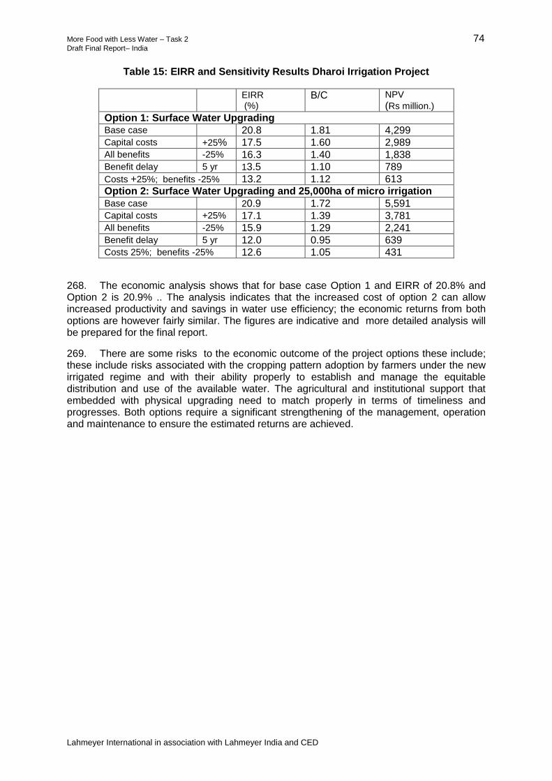
More Food with Less Water – Task 2 74 Draft Final Report– India
Lahmeyer International in association with Lahmeyer India and CED
Table 15: EIRR and Sensitivity Results Dharoi Irrigation Project
EIRR (%)
B/C NPV
(Rs million.)
Option 1: Surface Water Upgrading Base case 20.8 1.81 4,299
Capital costs +25% 17.5 1.60 2,989
All benefits -25% 16.3 1.40 1,838
Benefit delay 5 yr 13.5 1.10 789
Costs +25%; benefits -25% 13.2 1.12 613
Option 2: Surface Water Upgrading and 25,000ha of micro irrigation
Base case 20.9 1.72 5,591
Capital costs +25% 17.1 1.39 3,781
All benefits -25% 15.9 1.29 2,241
Benefit delay 5 yr 12.0 0.95 639
Costs 25%; benefits -25% 12.6 1.05 431
268. The economic analysis shows that for base case Option 1 and EIRR of 20.8% and Option 2 is 20.9% .. The analysis indicates that the increased cost of option 2 can allow increased productivity and savings in water use efficiency; the economic returns from both options are however fairly similar. The figures are indicative and more detailed analysis will be prepared for the final report.
269. There are some risks to the economic outcome of the project options these include; these include risks associated with the cropping pattern adoption by farmers under the new irrigated regime and with their ability properly to establish and manage the equitable distribution and use of the available water. The agricultural and institutional support that embedded with physical upgrading need to match properly in terms of timeliness and progresses. Both options require a significant strengthening of the management, operation and maintenance to ensure the estimated returns are achieved.

More Food with Less Water – Task 2 75 Draft Final Report– India
Lahmeyer International in association with Lahmeyer India and CED
VI. SANJAY SAROVAR IRRIGATION PROJECT
A. Overview
270. The Sanjay Sarovar scheme withdraws water from the Wainganga River, which is located in the upper part of the Godavari Basin, in southeast Madhya Pradesh. The Bhimgarh Dam and reservoir, with 410 Mm3 live storage, and was completed in 1995 and the canal systems completed in 2000. The Bhimgarh Dam consists of a 3,991 m long earthen dam and a 280 m of masonry dam. The scheme consists of a gravity irrigation system in two command areas:
(i) Tilwara and Bhimgarh Irrigation System: comprised of the command areas of the Tilwara Left Bank Canal and Bhimgarh Right Bank Canal (both located in the Seoni District). The canals are supplied from the Tilwara Feeder Canal from the Sanjay Sarovar Dam on the right bank of the Bhimgarh Dam; the Tilwara canals cross the river through the Tilwara syphon. The soils are black cotton soils. The two upper canals have an irrigation area of 66,150 ha. There is very limited groundwater in the Tilwara Irrigation System.
(ii) The Dhuty Left Bank Canal System: located in the Balaghat District and
withdrawing water by gravity from 1 km upstream of the Dhuty Weir. The Dhuty Left Bank Canal System covers 35,195 ha. The Dhuty Weir is located about 109 km downstream of the reservoir (125 km by road). The soils are mostly sandy loam.
271. A third command area, served by the Wainganga Main Canal, abstracts water from the right bank of the river above the Dhuty Weir; however, it is not part of the SSIP; no water allocation is made from the Bhimgarh Dam to the Wainganga Canal system.
272. The WRD is currently expanding the Tilwara Left Bank Canal Area by about 8,000 ha using government funds, on the basis that water savings from modernization of the SSIP would release additional water for Rabi irrigation. An Extension, Renovation and Modernization (ERM) proposal for the water efficiency program has been submitted for approval and finance. The proposal is for extensive lining of the system; the estimated costs of the proposal is $102 million (Rs. 615 crore)
273. The irrigated area of the SSIP is summarized in Table 16.
Table 16: Sanjay Sarovar Irrigation System CCA (ha)
Component
Current Area (ha)
Area including ongoing
expansion (ha)
A. Upper Area
Bhimgarh RMC (Seoni) 32,610 36,619 Tllwara LBC 12,646 20,596
Sub Total Upper Area 45,256 53,206 B. Lower Area
Dhuty Left Bank Canal System (Balaghat) 35,170 35,170
Total 80,426 88,376

More Food with Less Water – Task 2 76 Draft Final Report– India
Lahmeyer International in association with Lahmeyer India and CED
B. Water Resources
274. The dam intercepts a catchment area of 2,008 km2. At FRL of 519.38 m, the reservoir has gross and live storage capacities of 507 Mm3 and 410 Mm3 In the catchment of the dam, the maximum and minimum annual rainfalls are 1,748 mm and 647 mm, the average being 1,225 mm. The 75% dependable yield at the dam site is 703 Mm3. Ten radial type gates of size 15.24 m × 10.67 m have been provided at the spillway whose crest lies at 508.71 m.
1. Rainfall
275. The mean monthly rainfall is shown in Figure 8.
Figure 8: Mean Monthly Rainfall
2. Irrigation Releases
276. A schematic of the SSIP is shown in Figure 9.The reservoir operations are based on two seasonal operational models:
(i) During the Rabi season water from the Bimgarh reservoir (B) is released through the outlet to the upper command areas ( D) in Seoni district. During this period there is no allocation to the lower part of the scheme.
(ii) During the Kharif Season there is no allocation to the upper area in Seoni and
all the allocation is released to the river (C) given to the Dhuty Left Bank Canal (F). Water is released from the Bhimgarh Dam and picked up the Dhuty Left Bank Intake (F). The allocation to the Dhuty Left Bank Canal is meant to be the same as the release from the dam
(iii) The Wainganga Main Canal (G) on the right bank is allocated the natural
recharge (E) from the river over the 109 km reach from Bimgarh Dam.

More Food with Less Water – Task 2 77 Draft Final Report– India
Lahmeyer International in association with Lahmeyer India and CED
Figure 9: Sanjay Sarovar Schematic
C. Groundwater
277. Preliminary assessment of groundwater have been completed are presented in Appendix 11. The main findings of the groundwater studies include:
(i) Conjunctive use of surface water and groundwater is already practiced in an informal way in the two irrigation schemes. Use of groundwater is largely controlled by the availability and reliability of the surface water supplies from the canal system. Water deliveries are not possible in the current situation in some areas due to the condition of the existing infrastructure and management constraints, or may be limited when surface water availability is low. There may also be preference of farmers for using groundwater for reasons that are separate from surface water availability.
(ii) The limited resource availability of the combined surface water and groundwater system requires careful consideration in the choice of water use options. Availability of water may not be the only criterion for selection of options. Minimizing energy use may become an important consideration in the choice of options.
(iii) The option of conjunctive whereby the use of surface water is supplemented by pumped groundwater would appear the most flexible and could potentially minimize the investment required for system improvement. There would be
Bimgarh Reservoir
Bimgarh Right Bank Canal Tilwara Left Bank Canal
D
C
B
E
F G Dhuty Left Bank Irrigation System
Dhuty Weir
Wainaganga Right Bank
System
H

More Food with Less Water – Task 2 78 Draft Final Report– India
Lahmeyer International in association with Lahmeyer India and CED
good opportunity for zoning of water application, making optimum use of the existing water supply infrastructure. Improved water management would be required to avoid any risk of overuse of resource during lean water years and also to avoid energy use associated with pumping of groundwater. The opportunity for using the groundwater more extensively during time periods when surface water availability is constrained needs to be carefully investigated. Conversely, surface water could be used more extensively during other years/periods to allow the groundwater reservoir to refill.
D. Benchmarking
1. Main Findings
278. The initial results for the RAP internal indicators of the canal system are summarized in Table 17. These results are preliminary and incomplete; however, the indicators generally reflect a poor level of water delivery service and irrigation performance. Refer to Appendix 9 for the completed SSIP RAP worksheets.
Table 17: Sanjay Sarovar Irrigation Project Internal Indicators – Canal System
Dharoi Irrigation Project Value*
Actual water delivery service to individual ownership units (eg, field or farm) 1.1 Stated water delivery service to individual ownership units (eg, field or farm) 1.8 Actual water delivery service at the most downstream point operated by a paid employee 0.8 Stated water delivery service at the most downstream point operated by a paid employee 1.6 Actual water delivery service by the main canals to the second level canals 1.3 Stated water delivery service by the main canals to the second level canals 1.7 Social “order” in the canal system operated by paid employees 1.0
Main Canal
Cross regulator hardware (main canal) 0.9 Turnouts from the main canal 1.5 Regulating reservoirs in the main canal 0.0 Communications for the main canal 2.5 General conditions for the main canal 1.2 Operation of the main canal 1.9
Second-level Canals
Cross regulator hardware (second-level canals) 1.4 Turnouts from the second-level canals 1.3 Regulating reservoirs in the second-level canals 0.0 Communications for the second-level canal 2.6 General conditions for the second-level canals 1.2 Operation of the second-level canals 1.6
Third-level Canals
Cross regulator hardware (third-level canals) --- Turnouts from the third-level canals 1.0 Regulating reservoirs in the third-level canals 0.0 Communications for the third-level canals 2.5 General conditions for the third-level canals 1.3 Operation of the third-level canals 1.0
* Values are assigned to indicators and sub-indicators on a scale of 0 to 4 (0 indicating least desirable and 4 denoting the most desirable
Source: Present Study, 2014

More Food with Less Water – Task 2 79 Draft Final Report– India
Lahmeyer International in association with Lahmeyer India and CED
1. Benchmarking Indicators
279. The internal indicators are a measure of the flexibility, reliability, equity and measurement of the irrigation water supplies at different levels of the canal system. One can definitely say that the present water delivery service to individual fields in the SSIP is not close to the degree that would be required for modern farm irrigation methods. A specialized indicator that ranks the ability of the present water delivery service to support pressurized irrigation system is 0.3 out of a possible 4.0. Significant progress in the control and flexibility of the flows at this level should be a high priority for future modernization efforts. The RAP results indicate that the reliability and equity of farm irrigation deliveries is very poor. The inflexible nature of canal operations provides little flexibility to farmers, even though their very simple field irrigation techniques still require some level flexibility in order to be reasonably efficient.
280. There is a significant difference between quality of water delivery service as described in the project office questions and the actual service as assessed by the RAP indicators. For example, the actual water delivery service by the distributary canals to minor canals (0.8) compared to the stated service (1.6) is much different. The values given in the office for flexibility and equity were particularly overstated compared to the conditions found in the field. At the main canal level the difference between actual and stated water delivery service was closer (1.3 vs. 1.7). The WRD managers of the SSIP seem to have a relatively good understanding of the operational challenges experienced in the field, so this discrepancy is partly due to the inevitable better presentation of things that occurs at the beginning of an unfamiliar benchmarking exercise. However, it is also a reflection of widespread problems that exist in the system compared to the unintentional focus on areas that receive at least a minimum degree of service. It is an unspoken, but real acceptance, that tailenders cannot receive the same level of service in terms of reliability and equity in canal water supplies.
281. Another point to bear in mind about the internal indicators shown in Table 17 is that they attempt to reflect the situation more or less across the entire project, which in this case consists of two command areas that are 100 km apart from each other and that contain very different cropping patterns. Therefore, two points are relevant. The first is that conditions in some parts of the system are significantly worse (or better) than the indicators appear to show. Second, the RAP indicators for the SSIP are so low that in many cases the distinction between poor and extremely poor ratings is hard to meaningfully distinguish.
282. Ratings for the quality of water delivery service provided by the WRD at different levels of the system are progressively worse (eg, 1.3 at the main to distributary canal and 0.8 at the head of the minor canals), which in part is due to the fact that the WRD only concentrates on operations at the main and distributary level canals. The low service ratings for the main canal(s) highlight the need for an effective water delivery procedure that matches actual irrigation demands in the system. The sub-indicator measuring the degree to which the discharges into the distributary canals were equitable was particularly low (1.0). One sign of the severe inequity in the project is that crop yields during the Rabi season are estimated to be about 25-30% less in the tailend of the canal system vs. the headend, where water supplies are more readily available.
283. At the level of final deliveries to the individual field outlets, the very low rating for water delivery service (1.1) is due to the lack of flow measurement (0.0), prevalent inequities in the amount of available discharge (1.0), and uncertainties in the rotation schedule (1.5), depending on where an outlet is located within the system.
284. Of particular concern is the low rating for the “social order” indicator (1.0), which reflects the amount of widespread vandalism and broken structures/equipment (0.0) and an overall lack of effective control at all levels of the system in terms of whether discharges are within permissible limits (1.0) that would ensure more equity and reliability for all water users.

More Food with Less Water – Task 2 80 Draft Final Report– India
Lahmeyer International in association with Lahmeyer India and CED
285. The ratings of the indicator for operations at the main canal level is significantly better than the indicator for cross regulator hardware (1.9 vs. 0.9) based primarily on the fact there is often a small elevation change across the headworks of distributary canals relative to the water level fluctuations that occur. This means that fluctuations in water level in the main canal cause big variations in the offtaking discharges. Operations received relatively good ratings because there are formal and informal procedures in place whereby the WRD operators can and do respond to conditions further down in the canal network, but their capabilities to do are severely limited by the design and infrastructure in the system. There is some difference in the cross regulator hardware ratings between the main canals (0.9) and distributary canals (1.4), but this is primarily due to the shorter travel times. Integration of re-regulation reservoirs into the operation of the system would be beneficial in this regard.
286. The sluice gates used in the main and distributary canals are difficult to operate for maintaining constant upstream water levels, and the current level of maintenance is inadequate. However, even though some these gates are relatively well-maintained and can physically move relatively easily, the critical point is that the cross regulators in the system do a poor job of water level control.
287. The general conditions of the main, distributary and minor canals are relatively poor (1.2, 1.2, 1.3, respectively). These low ratings reflect a general lack of preventative maintenance and insufficient resources in terms of maintenance staff and equipment, and relatively high amounts of canal seepage, although more information is needed to make a reasonable estimate of the actual seepage losses.
288. The indicators for the offtakes from the main to distributary canals (1.5) was relatively low due to inadequate maintenance (1.0) and the fact that the functioning of the head gates of distributary canals (1.5) is difficult in terms of meeting targets for constants flows.
289. The ratings for communications in the scheme were similar at the main canal, branch canal, and minor canal level (2.5, 2.5, and 2.6, respectively). The sub-indicator ratings of the main and distributary canals for the frequency of communications with the next higher and lower levels were relatively high because as indicated previously the operators are in regular contact with each and do try to respond to current needs in the system.
E. Summary of Stakeholder Consultations
290. Four PRAs were conducted in the SSIP project command area including two in the head reach and two in the tail reach villages, in both the upper and lower command areas. The objectives were to undertake a rapid situation analysis and receive farmers’ feedback about issues and requirements to improve irrigated agriculture. The PRA was developed comprising a set of 170 questions to understand the current situation, issues, and probable solutions perceived by the farmers for improving canal system, irrigation and agriculture, etc. In addition local seed and agriculture input retailers and distributors were also interviewed to know their engagement , experiences and willingness to work with farmers for improving their services. The full stakeholder reports are given in Appendix 14. A summary of findings and recommendations are given as follows:
(i) The irrigation systems are 20-30 years old and farmers identified the need for rehabilitation. Farmers suggest the government should support rehabilitation of structures, lining and gates including provision of locks. The WUAs have managed to increase the irrigated areas through PIM, and WUAs should be allowed to retain water charges for operation and maintenance of the lower level canals.
(ii) Head reach farmers take more than their fair share of water. More than 50% of respondents were in favor of water measurement down to field channels to allow more equitable water allocations.

More Food with Less Water – Task 2 81 Draft Final Report– India
Lahmeyer International in association with Lahmeyer India and CED
(iii) Field channels are unlined. Some trials using semi-circular pipes were implemented in Seoni District, but these were removed by land owners due to lack of water. Farmers are reluctant to provide land for field channels. Farmers recommended the use of buried pipe instead of field channels-indicative layouts were discussed during walk-throughs.
(iv) The WUAs are fully dependent on government funding and their functional capability collapses when funds are not provided. All the records are kept by the WRD and no information is held by WUA. The WUAs are mandated to collect water charges but there is no incentive and officials do not have any office and administrative capacities. The officials of the WUAs do not receive any incentive for their services. The operation and maintenance grant for tertiary canals of $1 per ha is insufficient.
(v) There has been no training beyond a once-only training of the WUA chairman after his election received at WALMI. Experience has shown that WUAs need long-term continuous support and training. This can be outsourced but the support must be permanent and sustainable requiring access to long-term financial support.
(vi) On an average 60% village farmers use only groundwater, 10% use only canal water, 20% use both canal and groundwater and rest 10% don’t have access to any sources reported in PRAs.
(vii) Water scarcity is most severe at the end of Rabi irrigation and in early summer. Farmers identified the role of WUA to provide a combined surface and groundwater management and stated without this the WUA cannot be a long-term sustainable institution. Moves to integrate surface and groundwater can be initially developed by check dam in the drains, but long-term use of pipe distribution and drips/sprinklers fed by surface and groundwater are required.
(viii) Farmers were very firm that that the WUA needs manage all water sources canal /groundwater/ ponds / tanks etc. without this it will not be a viable and sustainable institution in the long-run.
(ix) Groundwater and canal water should be used more efficiently by construction of ponds and checkdams on the local drain (nala) and river and subsequently joining them through pipe networks and drip irrigation systems. Taking tubewell and open well owners on the Board will be difficult task for the WUAs, but it is not impossible either. Reputed NGOs can help the government and the WRD to implement these ideas.
(x) The WUAs have no access to supporting agencies including the Agriculture Department. The WUA officers reported they were keen to work with different organizations but they lacked the key links. The WUAs had no office for meetings and storing records.
(xi) There is currently no incentive for water saving in the canals. The WUAs should have a widened remit to collect water charges and directly use the finds for operation and maintenance. There are no rules governing water allocations and the warabandi rotation system is not working.
(xii) Farmers were found to be not comfortable with the drip sprinkler systems and could not afford the investments. Drip systems were not appropriate with flood irrigation crops. Pilot drip systems using surface water should be piloted as demonstrations to bring up farmer confidence.

More Food with Less Water – Task 2 82 Draft Final Report– India
Lahmeyer International in association with Lahmeyer India and CED
(xiii) The PRA identified that current agriculture extension agencies did not provide adequate and timely services. There is no soil testing, resulting in farmers having to use ad hoc estimates fertilizer requirements. Simple private sector soil testing should be established; farmers stated they were willing to pay.
(xiv) Farmers reported they were getting less than optimum yields due to poor advisory services and lack of access to good inputs. Seed replacement was also too low and there was lack of advice on new seed varieties. Farmers require support in improved fodder. Farmers were keen on livestock but need technical support. Farmers preferred high water consuming crops like paddy which give good returns.
(xv) Only about 30% of farmers were found to be satisfied with agriculture in general. The younger generation is especially not interested in farming activities. Women have a greater role than men in farm operations and they reported health issues and requested support for simple farm tools. New initiatives are required to keep younger and more educated farmers engaged in agriculture including increasing scope for skill development and opportunities for enterprises and increasing the use of mechanical equipment. There is a current lack of agriculture machinery. Pilots to promote low cost technologies were proposed by the farmers.
(xvi) Farmers rarely cleaned their produce as there was no financial incentive. Farmers felt there was an urgent need for village-level crop storage (godowns) as they do not have adequate space in their houses.
(xvii) Farmers reported a lack of access to market information and often sold their product at poor prices; farmers did not use the Krisan call center. Private sector brokers procure the produce at the farm gate, but at reduced prices. Farmers identified difficulties to obtain credit, particularly from banks. The PRAs identified the importance of crop insurance but there had been problems in settling claims.
(xviii) The WUAs officers and farmers felt the WUAs were inadequate to manage the complex issues of irrigation management including canal and irrigation and agriculture inputs and a parallel more commercial organization is required. There seems to be a call for forming two separate organizational arrangements for (a) natural resource management like water, irrigation and land development under the prevailing government acts like PIM, and (b) for watershed development with some integration of groundwater and surface water management.
(xix) There should be a separate farmer’s organization for more commercial activities, including input and output value chains of agriculture such as krisan clubs at village level and producer groups (seed, organic inputs, etc.), women saving and credit SHGs. There is a need for an apex level farmer producer company that works closely with private suppliers and buyers facilitated by NGOs and supervised by government and an independent agency in long-run. It should be noted that the state is one of the leading states of the country and has promoted more than 100 FPCs in the last 10 years. These FPCs, their business plans, and overall experience must be studied before pilot project strategy of promoting FPCs.
(xx) Discussion with farmers identified that they do engage with private sector, but this is only for procurement of inputs and there was no experience of cooperation on production and marketing. Commercial companies were interested to work with farmer producer organizations.

More Food with Less Water – Task 2 83 Draft Final Report– India
Lahmeyer International in association with Lahmeyer India and CED
F. Strategic Planning for the SSIP
1. Context
291. The previous sections present assessments of the SSIP including responses of the stakeholders (including farmers and operations and extension personnel) to the present situation. The plan for irrigation modernization and management reforms has to fit the complex situation of the SSIP, and wherever possible, have incorporated the points raised by the stakeholders. The current irrigation setting is summarized in Table 18.
Table 18: Irrigation Setting at the SSIP
Parameter Situation Points
Area The cultivated command area is 80,500 ha of cultivable command area. The scheme is in two parts an upper area in Seoni division of 45,300 ha and a lower part in Balaghat division of 35,200 ha
The WRD is currently expanding the left bank irrigation area by 8,000 ha. Work is ongoing using government funds. The plan is that a 15% increase in conveyance efficiency from canal lining would allow increased water availability irrigate this area.
Area Currently Irrigated
Irrigation during the Rabi is provided only to the upper area and the main crop is wheat.
Irrigation is provided during the Kharif season to irrigate the lower area in Balaghat and currently 85% of the area grows wet season rice. There is no allocation irrigation during Rabi to the lower area.
The lower area now is using groundwater to support a rabi irrigated summer rice crop.
Groundwater The upper area has only limited groundwater use, currently about 5500 ha or 10% of area is irrigated from groundwater.
In the lower area almost 100% of the Rabi crop is by groundwater.
In the upper area there is only limited potential to expand groundwater-poor yields limit the groundwater to dug wells.
There would appear to be good potential to improve groundwater management to expand groundwater irrigation in the lower area. Recharge from rainfall and wet season irrigation is reasonable.
Water Management
During Rabi currently surface water is providing irrigation to 40,000 ha (49%), groundwater is supplying 14,000 ha (30%) and 26,500 ha (21%) is not planted.
Groundwater plays an important role in the project and development of conjunctive irrigation management is proposed.
The Dhuty Left Bank Canal is in the same hydrological unit, but is not fully considered in the water resources planning. Future water management should include the Dhuty Left Bank Canal.
Energy There is an increasing use of groundwater in the lower area mainly using diesel pumps. The options for introducing micro irrigation are constrained by the lack of reliable electric power.
Improving availability of energy is a key requirement to be incorporated into the scheme planning to allow for electrification of pumps and micro irrigation.

More Food with Less Water – Task 2 84 Draft Final Report– India
Lahmeyer International in association with Lahmeyer India and CED
Parameter Situation Points
Operation and Maintenance Costs
Current allocations are estimated to be around $3.1 million.
Increasing efficiency will result in increased operation and maintenance costs. Current allocations for maintenance are very low.
Agriculture In the upper command area, the original design was for Kharif rice followed by wheat. During the initial years, farmers planted rice but it was reported to be not very successful and the farmers switched to rainfed soybeans and no irrigation water was allocated. Recently, farmers report problems of soybeans and the Kharif cropping has almost collapsed although some return to rainfed paddy is occurring. In the Rabi season, almost all the farmers grow wheat.
The upper area is largely unsuitable for irrigated wet season rice. Farmers need support to develop alternative crops including analysis of why the soya crop has failed.
Irrigation of Rabi crops by surface water is inefficient and farmers have shown an interest in micro irrigation.
Only around 30% of farmers were satisfied with agriculture.
Management Structure
The project is managed by two separate divisions. Management is focused on the main infrastructure. WUAs report lack of support.
WUAs From the RAP benchmarking the WUAs had a relatively low score. Even though charges are relatively low as although they do have some influence on real time management they are organizationally weak, partly due to the low level of surface water irrigation in the system.
The WUAs, although initially constituted, have never been renewed after expiry of their term.
Farmers identified that the WUAs need to manage all water sources including surface and groundwater.
2. Proposals for Agriculture
292. The current cropping systems in the are very different in the upper and lower areas. Groundwater is used to meet the shortfall in surface water.
293. The current and proposed cropping for the SSIP is shown in Table 7 the crops are irrigated by surface and groundwater.
(i) In the upper area during the Rabi the main crop is wheat with some gram. The Kharif cropping was until recently rainfed soya bean however there was a major disease problem and farmers have stopped soya beans and taken up some limited paddy. For the future wheat is less profitable and an increased uptake of vegetables is considered appropriate if water supplies can be improved. Water savings by the investments would be used to supply the additional area currently being constructed in the Tilwara Left bank area.
(ii) In the lower area during Rabi there is only very limited water and most of the
cropping is supplied by groundwater. In recent years there has been a significant uptake of summer paddy which is grown during January to May. Farmers are getting good yields and returns despite the high costs of groundwater pumping. During Kharif the predominant crop is paddy however yields are quite low.

More Food with Less Water – Task 2 85 Draft Final Report– India
Lahmeyer International in association with Lahmeyer India and CED
294. For the future with project it is estimated that the cropping pattern in the upper area would not change; some reduction in wheat and increase in vegetables would provide improved returns through better assured water including micro irrigation in option 2. The water saved would be assigned to the 7900ha of expansion currently under construction on the left bank of the upper area.
295. In the lower area there is scope to increase the area of Kharif paddy as well as rabi summer paddy and vegetables. There is a need to look at lower water consuming ways to grow rice (eg, SRI has good potential and is already being practiced in a limited area). There is only limited scope for rabi surface water irrigation and the expansion of the irrigation would be through improved groundwater management and introduction of 10,000ha of micro irrigation.
296. Increased availability of surface water and groundwater together with agriculture support would allow an increase in yields. The current yields are shown against the potential which is the value farmers could potentially achieve. Introduction of micro irrigation will improve efficiencies and yields two target yields for the ‘with project’ situation are shown; the target surface yield is achievable with surface water irrigation improvements and a higher value for the areas under micro irrigation.
Table 19: Current and Proposed Cropping for the SSIP
3. Proposals for Water Management
a. Objectives
297. The objectives for the modernization of the SSIP is to (i) improve the WUE and POW of irrigated agriculture; and (ii) to reduce the use of groundwater to sustainable levels and (iii) allow expansion of the CCA by 8,000ha.
Irrigable Area (ha)Cultivated Command Area Current (ha) 80,426 Cultivated Command Area Future (ha) 88,326
Period Current % Future % CurrentPotential
Target
Surface
Target
Micro
Upper Area CCA ha 45,256 45,256 53,156
1 Wheat Nov-Mar Rabi 41,000 91% 41,000 77% 2.4 5.5 3.5 4.2
2 Soya bean Jun-Sep Kharif 20,000 44% 20,000 38% 1.3 2.0 1.5 1.5
3 Gram Nov-Jan Rabi 2,000 4% 3,000 6% 0.6 1.2 0.8 1.0
4 Paddy Jul-Oct Kharif 6,000 13% 6,000 11% 2.0 3.0 2.5 2.5
5 Vegatables (Rabi) Nov-Jan Rabi 0% 9,000 17% 25.0 50.0 35.0 40.0
Total crop during Rabi 43,000 95% 53,000 100%
Total crop during Kharif 26,000 57% 26,000 49%
Total Upper 69,000 152% 79,000 149%
Lower Area CCA (ha) 35,170
1 Paddy Jul-Oct Kharif 30,000 85% 34,000 97% 2.8 5.5 3.5 4.0
2 Wheat Nov-Mar Rabi 500 1% 8,000 23% 2.4 5.5 3.5 4.2
3 Summer Paddy Jan-April Rabi 8,000 23% 18,000 51% 4.0 7.0 5.0 5.5
4 Vegetables (Rabi) Nov-Jan Rabi 0 7,000 20% 25 50.0 35 40.0
Total Lower 38,500 109% 67,000 191%
Total crop during Rabi 8,500 24% 33,000 94%
Total crop during Kharif 30,000 85% 34,000 97%
Total All 107,500 134% 146,000 182%
Nr Seasons & Crops Season
Area (ha) Yield (T/ha)

More Food with Less Water – Task 2 86 Draft Final Report– India
Lahmeyer International in association with Lahmeyer India and CED
b. Water Balance
298. A simple water balance for the SSIP has been prepared to help understand the surface and groundwater balance for different levels of irrigation release from the Bhimgarh Dam as shown in Table 20. The analysis examines the impacts of different interventions in the upper and lower areas. A summary of the irrigation areas and efficiency parameters used in the analysis are shown in Table 21.
Table 20: SSIP Dry Season Water Balance
Water Case 10% DY 25% DY 50% DY 75% DY 90% DY
Irrigation Release from Bimgarh Dam 442 424 385 317 212
Annual Rainfall (mm) 2,032.70 1,561.14 1,138.10 803.49 603.70
1. Upper Area Current (45,426ha)
Surface Water (mm) 389 373 339 279 186
Area by irrigable by surface water (ha) 40,855 39,132 35,544 29,256 19,544
Area by groundwater (ha) 6,294 9,882 16,170 25,882
Total area (ha) 40,855 45,426 45,426 45,426 45,426
2. Upper Area with surface water upgrading (53,376ha)
Surface Water (mm) 381 365 332 273 182
Area irrigable by surface water (ha) 43,750 41,905 38,063 31,330 20,929
Area by groundwater (ha) - 6,294 9,882 16,170 25,882
Total area (ha) 43,750 48,199 47,945 47,499 46,811
3. Upper Area with surface water upgrading and 30,000ha micro (53,576ha)
Surface Water (mm) 497 476 433 356 238
Area by surface water (ha) 48,566 46,517 42,253 34,778 23,233
Area by groundwater (ha) 6,294 9,882 16,170 25,882
Total Area (ha) 48,566 52,812 52,134 50,948 49,115
4. Lower Area Current
Current Surface Water Allocation (mm) - - - - -
Area by Surface Water (ha) - - - - -
Area by groundwater (ha) 8,500 8,500 8,500 8,500 8,500
Shortfall by groundwater(mm) 329 329 329 329 329
Groundwater requirement (Mm3) 193 193 193 193 193
5. Lower Area (Upgrading and 10,000ha Micro)
Surface Water Allocation (mm) - - - - -
Area by Surface Water (ha) - - -
Area by groundwater (ha) 33,000 33,000 33,000 33,000 33,000
Shortfall by groundwater(mm) 740 740 740 740 740
Groundwater requirement (Mm3) 394 394 394 394 394

More Food with Less Water – Task 2 87 Draft Final Report– India
Lahmeyer International in association with Lahmeyer India and CED
Table 21: Crop Water Requirements and Irrigation Efficiencies
299. The analysis shows a preliminary water balance for five water-availability situations. Considering the average year (50% DY) the following observations are made:
(i) Current situation: for the upper command area there is sufficient surface water for 35,500 ha leaving a requirement of about 10,000 ha of groundwater. This is supported by reports of around 10,000 dug wells in the upper area. Groundwater use increases to about 16,000 ha in a 75% DY.
(ii) The WRD is currently expanding the scheme area on the left bank by about
8,000 ha which will expand the CCA from 45,300 ha to 53,300 ha. Surface water upgrading would increase efficiency from about 40% to 46% allowing the area under surface water to increase by 2,500ha to 38,000 ha. Plus 10,000 ha from groundwater (assuming unchanged) this would allow about 48,000 ha of Rabi irrigation about 90% of the planned CCA of 53,300 ha.
(iii) For the ‘with-project’ surface water upgrading plus 30,000 ha of micro irrigation
in the upper area; the irrigated by the surface water could supply 42,200 ha, adding 10,000 ha of groundwater this gives an irrigable area of 52,000 ha.
(iv) The improved conveyance efficiencies in the upper area would indicatively
allow supply to the ongoing 8,000 ha expansion of the upper area but would not allow for any additional supply to the lower area.
(v) The lower area currently receives only very small surface water in the dry
season and for the Rabi it will largely continue as a groundwater only project. Current Rabi irrigation area is 8,500 ha. The viability of increasing this area has been examined.
(vi) Sustainable groundwater in the lower area must be balanced by the recharge.
The current abstraction from groundwater for 8,500 ha is 329 mm. The long-term sustainable increase on the groundwater area will depend on the recharge.
Current
56%
micro
Lower
28%
micro
CCA Areas (ha)
Upper 45,300 53,300 53,300
Lower 35,200 35,200 35,200 Lower area unchanged
Weighted average crop water requirements (mm)
Upper 433 465 465 465
Lower 329 740 740 740
Overall Efficiencies
Surface Water 40% 46% 60% NA
Ground Water 60% 60% NA 66%
Future Surface
Upgrading plus
micro
Future
Surface
Upgrading
Crop water requirements
based on current and future
cropping patterns
Notes
Upper area increases to
include expansion of left bank
irrigation area

More Food with Less Water – Task 2 88 Draft Final Report– India
Lahmeyer International in association with Lahmeyer India and CED
(vii) .The indicative recharge and abstraction balance for an average year in the lower area is shown in Table 22.
Table 22: Lower SSIP Recharge Targets
Contribution Recharge (mm) Source of Recharge
Recharge from rainfall (20% of average rainfall 1,138 mm)
230
Natural recharge and recharge from irrigation 550 mm
Recharge from Kharif season irrigation supply (30% of 121 Mm
3)
100
Recharge from Rabi crops (30% of 740 mm)
220
Supplementary recharge from increased wet season allocations
100 Additional recharge through improved surface and groundwater management 190mm
Benefit from inter-annual groundwater management (10% of difference between 10% dry year and 50% dry year rainfall
90
Total potential recharge 740
300. From the table the recharge is in two categories: (i) natural recharge, and (ii) irrigation recharge which largely occurs by default (550 mm). In addition there is scope to increase recharge by about 30% through conjunctive water management (160 mm).
301. Conjunctive water management would include using wet season flows to support additional recharge. In addition, inter-annual groundwater management can allow for increased abstraction by using the storage in the aquifer. The use of the groundwater can be increased during years when surface water is in short supply and reduced during wet years when surface water is in surplus. The basic concept of this type of regulation is the use of the groundwater system as an underground reservoir from which water can be extracted at a rate in excess of natural and surface water irrigation induced recharge. The depleted groundwater reservoir would be re-filled during years when rainfall and surface water availability are high.
302. The numbers are indicative but it estimated with conjunctive groundwater management there would be could be enough recharge to support about 20,000ha of groundwater irrigation. This is based on no surface water use in the dry season however in reality some surface water allocation would be likely.
c. Conjunctive Surface and Groundwater Management
303. Currently, irrigation in the SSIP is by default a conjunctive surface and groundwater system with the groundwater meeting about 55% of the irrigation supply. The conjunctive water balance is complex and currently there is only a limited data and understanding.
304. The direction of the water management program is to move towards 'planned conjunctive management' based on core objectives of:
(i) Increasing the reliability of irrigation supply and improving crop productivity through improved by improved surface water supply, better coordinated management of surface and groundwater.
(ii) Increasing the efficiency of the surface water irrigation to maximize the area served by surface water and reduce the dependency of groundwater including the development of piped and micro irrigation.

More Food with Less Water – Task 2 89 Draft Final Report– India
Lahmeyer International in association with Lahmeyer India and CED
(iii) Developing conjunctive surface and groundwater management systems to optimize the use of each resource to balance the uncertainties of rainfall as well as meeting the objectives of reducing abstractions from the deep aquifer..
(iv) Improving the availability of electric power to allow access to electric pumping for groundwater and micro irrigation. Power would be managed through (a) developing charging systems based on power consumed rather than pump size; (b) provide variable tariffs to restrict unsustainable groundwater pumping and (c) introducing prepaid meters to simplify and improve payment mechanism for electricity.
(v) Investment in a solar power station to improve power availability.
(vi) Developing inter-annual conjunctive use which implies the enhanced use of groundwater during years when surface water is in short supply and reduced groundwater use when surface water is in surplus. The basic concept of this type of regulation is the use of the groundwater system as an underground reservoir from which water can be extracted at a rate in excess of natural and surface water irrigation induced recharge. The depleted groundwater reservoir would be re-filled during years when recharge surface water availability are high.
(vii) Improving water availability through piped distribution networks and micro irrigation systems. In the upper area, the micro irrigation systems would be supplied by surface water; in the lower area the micro irrigation would be supplied by groundwater.
(viii) Developing institutional models to integrate surface and groundwater service providers through service agreements.
4. Proposals for Energy Management
305. There are quite restricted electric power supplies in the SSIP and farmers mainly use diesel pumps. The plan for Option 2 is to improve the efficiency of groundwater pumps by provision of electricity as well as provide electrical energy for pumping for micro irrigation.
306. The estimated power requirement for Option 2 is 20 MW of power; 8 MW for the groundwater and 12 MW for micro irrigation.
307. Developing an electric supply specifically for irrigation is expensive and requires generating capacity, management and upgrading and extension of power network. Options for power include solar power, power from bio-fuels, or oil. There may also be opportunities to use sugar waste to generate power. The incorporation of power generation into the scheme design allows a fast take up of micro irrigation as well as support for groundwater. Solar power is attractive because of the low capital costs and low operational costs. Stand-alone solar pumps and panels require costly variable speed motors and over a year the irrigation demand would use less than 50% of the potential power produced. A central solar farm is more attractive as the surplus energy can be sold to the grid. A combined solar-grid supply can be introduced where grid supply can be used to complement the solar when demand exceeds supply and the solar power can be sold to the grid if solar supply exceeds demand. Management of solar power is simpler than mechanical generation and security of the panels is significantly higher with a centralized unit.
308. Solar power costs have significantly reduced over recent years. To make the necessary financial returns of 12% would require a tariff of $0.12/kW-hr. By using the power to pump groundwater and support agriculture sustainability there is significant value added to the power investment. Access to low cost finance can significantly improve the viability of solar power; borrowing at 4%, the tariff would be 0.09/kW-hr.

More Food with Less Water – Task 2 90 Draft Final Report– India
Lahmeyer International in association with Lahmeyer India and CED
309. Energy tariffs to be applied to meet the criteria of (a) affordability by farmers, (b) to cover the costs of power as well as the costs of service delivery of groundwater or surface water, and (c) meet the needs of water conservation. It is proposed that pre-paid meters are used as a means to charge for pumping.
310. Prepaid meters have been used around the world for many years for domestic electricity and water supply, and more recently, for irrigation. The prepaid meter like the prepaid phone card requires the user to pay in advance and avoids the long and costly process of meter readings, issuing bills and collecting payment. For the communal water use such as an irrigation pump the use of prepaid cards allows the farmer to buy credit on a prepaid card. The card is inserted into the prepaid meter and the amount payable deducted from the credit on the card. The prepaid meters are programmable to allow different tariffs according to the water source (surface, deep or shallow groundwater and quota levels)
5. Investment Plan
311. The SSIP urgently requires investment to upgrade and modernize the irrigation system. The scheme is complex in two parts lying in two different zones with very different soil and farming systems.
312. Two investment options for the SSIP are presented and assessed:
(iii) Option 1: Upgrading and modernization of the surface water system, including the development of improved surface water management: Option 1 would incorporate necessary upgrades to control and measurement infrastructure, construction of essential new facilities for re-regulation of canal flows, repairs to existing structures, targeted canal lining, and the introduction of decision support systems and remote monitoring networks. Strengthening of institutions would be undertaken to better manage surface water resources, including comprehensive water management planning that governs all aspects of water deliveries, scheduled maintenance, and cost recovery (payment amounts and fee collection).
(iv) Option 2: Upgrading and modernization of surface water system together
with conjunctive groundwater management, micro-irrigation and agriculture support: Option 2 would incorporate the proposals for surface water modernization as proposed in Option 1 and in addition would include 40,000 ha of micro-irrigation supplied by conjunctive surface and groundwater. Surface water management would be extended to integrated management of surface water, groundwater and power. Agriculture support initiatives would be developed through promotion of commercial initiatives including increased involvement of the private sector. The outcome would be the establishment of long-term and sustainable institutional arrangements with capacities and resources for holistic management of surface and groundwater resources and energy.
313. The SSIP investment plan is presented in Table 23.

More Food with Less Water – Task 2 91 Draft Final Report– India
Lahmeyer International in association with Lahmeyer India and CED
Table 23: SSIP Investment Plan
6. Operation and Maintenance Costs
314. The estimated operation and maintenance costs are given in Table 24.
$ million Rs Crore % $ Rs Crore %
A. Bhimgarh Right Bank Canal
Bhimgarh Right Bank Main Canal 22.3 134.0 26 22.3 134.0 26
Distributory Canals 6.8 40.8 8 6.8 40.8 8
Drainage 0.3 1.7 0 0.3 1.7 0
B. Tilwara-Feeder Canal /LBC Main canal - -
Main Canal 18.2 109.0 21 18.2 109.0 21
Distributory Canals 3.9 23.6 5 3.9 23.6 5
Drainage 0.2 1.3 0 0 1.3 0
C. Dhuty Left Bank Canal
Main Canal 18.8 112.9 22 18.8 112.9 22
Distributory Canals 10.0 60.2 12 10.0 60.2 12
Regulation Reservoirs 2.1 12.7 2 2.1 12.7 2
Minors 2.3 13.9 3 2.3 13.9 3
D. SCADA Systems 1.0 6.0 1 1.0 1
Sub Total 86.0 516.1 100 86.0 516.1 100
II PIPE DISTRIBUTION AND MICRO IRRIGATION
1 Buried pipe distribution 40,000ha 28.0 168.0 35
2 Upgrading of electrical distribution 40,000ha 8.0 48.0 10
3 Micro Irrigation 40,000ha 18.0 108.0 23
4 20MW solar power plant for micro irrigation and
groundwater 26.0 156.0 33
Sub Total 54.0 480.0 100
III AGRICULTURE SUPPORT INITIATIVES
1 Crop Storage and Marketing Systems 4.0 24 33
2 Support for Farmer Enterprises 3.0 18 25
3 Other Agricultural Support Intitatives 3.00 18.0 100 5.0 30 42
Sub Total 3.0 18.0 100 12.0 72.0 100
IV 0.7 4.2 1.5 9.0
V CONSULTANCY AND MANAGEMENT SUPPORT - -
1 Planning, feasibility studies and design 2.6 15 19 4.2 25 19
2 Supervision of construction 4.3 26 31 7.0 42 31
3 Establishment of New Management Organization 6.9 41 50 11.2 67 50
Sub Total 13.8 82.6 100 22.4 134 100
VI
10.0 60 100 12.2 73 100
VII0.6 3.6 100 0.6 3.6 100
TOTAL INVESTMENT 114.1 684.3 188.7 1,288.1
CONTINGENCIES 15% 17.1 102.6 28.3 193.2
TOTAL INVESTMENT 131.2 787.0 - 217.0 1,481.3
Cost per ha ($/ha) 1,378 2,279
OM BUDGET SUPPORT DURING
IMPLEMENTATION PERIOD
LAND ACQUISITION
OPTION 1-Modernization of
the canal systems and
improved management
Option 2: Modernization of the
canal systems, conjunctive
management plus 40,000 ha
piped/micro irrigation
I. UPGRADING OF SURFACE WATER CANAL SYSTEMS
TRAINING AND AWARENESS
ItemNr

More Food with Less Water – Task 2 92 Draft Final Report– India
Lahmeyer International in association with Lahmeyer India and CED
Table 24: SSIP Estimated Costs for Operation and Maintenance
7. Upgrading of the Canal Systems
315. Upgrading of the canal systems is a core requirement for both options. Surface water is extremely limited and maximizing the efficiency of the canal and water allocation systems is a key requirement. The investment requirements of the upgrading work are summarized in Table 25.
Total ($
million)
Cost/ha
($)
Total ($
million)
Cost/ha
($)
Total ($
million)
Cost/ha
($)
Surface Water
Personnel costs 1.5 19 2.0 24 1.9 24
Canal Maintenance 0.1 1 2.4 30 2.4 30
Other Misc OM Costs 1.5 19 2.0 24 1.9 24
Total Surface Water 3.1 39 6.3 78 6.3 78
Farmer Systems
Groundwater 1.7 85 3.7 85 1.73 60
Micro Irrigation 4.2 104
Total Farmers Systems 1.7 18 3.7 38 5.9 62
Total OM Costs 4.8 51 10.0 105 12.2 128
Areas of Irrigation
1.Surface Water Irrigation Upper Lower Upper Lower Upper Lower
Kharif 0 30,000 - 34,000 - 34,000
Rabi 33,000 500 33,000 1,000 33,000 4,000
2. Groundwater Irrigation (Rabi) 10,000 8,000 10,000 33,000 10,000 29,000
3. Pipe distribution and micro irrg. 30,000 10,000
Notes
2. Micro irrigation based on 90% sprinkler and 10% drip pumping head 25m electric tariff Rs7/kw-h
3. Support for OM costs during investment period; 20% of OM costs over 5 year period
1. Groundwater costs based on average pumping head 7m diesel pump, option 2 includes savings
due to partial conversion to electric pumping
ha
Current Option 1 Option 2
Modernization of
canal systems and
improved
management
Modernization of the
canal systems,
conjunctive
management and
40,000 ha piped/
micro irrigation
Component
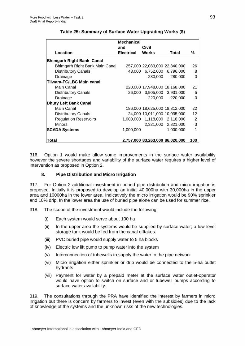
More Food with Less Water – Task 2 93 Draft Final Report– India
Lahmeyer International in association with Lahmeyer India and CED
Table 25: Summary of Surface Water Upgrading Works ($)
316. Option 1 would make allow some improvements in the surface water availability however the severe shortages and variability of the surface water requires a higher level of intervention as proposed in Option 2.
8. Pipe Distribution and Micro Irrigation
317. For Option 2 additional investment in buried pipe distribution and micro irrigation is proposed. Initially it is proposed to develop an initial 40,000ha with 30,000ha in the upper area and 10000ha in the lower area. Indicatively the micro irrigation would be 90% sprinkler and 10% drip. In the lower area the use of buried pipe alone can be used for summer rice.
318. The scope of the investment would include the following:
(i) Each system would serve about 100 ha
(ii) In the upper area the systems would be supplied by surface water; a low level storage tank would be fed from the canal offtakes.
(iii) PVC buried pipe would supply water to 5 ha blocks
(iv) Electric low lift pump to pump water into the system
(v) Interconnection of tubewells to supply the water to the pipe network
(vi) Micro irrigation either sprinkler or drip would be connected to the 5-ha outlet hydrants
(vii) Payment for water by a prepaid meter at the surface water outlet-operator would have option to switch on surface and or tubewell pumps according to surface water availability.
319. The consultations through the PRA have identified the interest by farmers in micro irrigation but there is concern by farmers to invest (even with the subsidies) due to the lack of knowledge of the systems and the unknown risks of the new technologies.
Location
Mechanical
and
Electrical
Civil
Works Total %
Bhimgarh Right Bank Canal
Bhimgarh Right Bank Main Canal 257,000 22,083,000 22,340,000 26
Distributory Canals 43,000 6,752,000 6,796,000 8
Drainage 280,000 280,000 0
Tilwara-FC/LBC Main canal
Main Canal 220,000 17,948,000 18,168,000 21
Distributory Canals 26,000 3,905,000 3,931,000 5
Drainage 220,000 220,000 0
Dhuty Left Bank Canal
Main Canal 186,000 18,625,000 18,812,000 22
Distributory Canals 24,000 10,011,000 10,035,000 12
Regulation Reservoirs 1,000,000 1,118,000 2,118,000 2
Minors 2,321,000 2,321,000 3
SCADA Systems 1,000,000 1,000,000 1
Total 2,757,000 83,263,000 86,020,000 100

More Food with Less Water – Task 2 94 Draft Final Report– India
Lahmeyer International in association with Lahmeyer India and CED
9. Solar Power Plant
320. A 20-MW solar power plant would be built to provide power for pumping of groundwater and micro irrigation. The power would be restricted to the pump systems but would sell power to the grid outside the irrigation period. All the pumps would be fitted with prepaid meters and farmers would pay for power in advance. The solar plant would be built through a PPP DBO contract.
10. Agriculture Support
321. From the PRAs it has been found that farmers lack sufficient information and support to achieve the full potentials of irrigated agriculture. The extension services staff are under-resourced with insufficient capacities support uptake of modern and high productivity irrigated agriculture, so it is proposed that agricultural support be provided as a part of the investment in irrigation modernization. The project proposals for irrigation modernization require support from parallel investments in the agricultural systems, and therefore it is proposed that significant funding would be allocated towards intensive, professionalized agricultural support services in both the schemes.
322. This parallel investment in agriculture support will facilitate increased crop yields and better financial returns, including a faster uptake of new agricultural technologies, such as micro-irrigation. To achieve long-term sustainability it is proposed that the agriculture support program is based on commercial activities through PPP contracts with seed money for startup costs supported by the investment program. Activities would be designed to ensure financial viability which allows the programs to grow, self-financing and sustainable. The intention is to offer a nucleus of localized self-financing support services, either directly or by interacting and engaging with existing government agriculture programs, commercial agriculture companies, NGOs and farmer-level producer organizations. It is envisaged that the agriculture support initiatives would be a mix of those by a specialized central-level unit together with decentralized initiatives. Initiatives could include (i) support for crop storage and marketing systems to allow farmers improved opportunities to get improved returns for their crops, (ii) improved and more timely supply of inputs at fair market prices, (iii) higher quality and more availability of training and extension services, and (iv) contract farming to open up new technologies, farming and marketing systems.
323. The sustainability of the agricultural support program will be achieved through the commercial activities through PPP contracts. Start-up costs would supported by the investment but would be self-financing after the end of the project period. During the initial 5 years financial support from the investment program can be used to establish agriculture support activities; the program must however create revenue that can be put aside into an agriculture support fund in an escrow bank account. At the end of the 6-year project period the support fund would be used as capital to continue to the agriculture support program on a long-term sustainable basis.
11. Training and Awareness
324. One of the main issues identified for the poor performance of the SSIP has been the of poor understanding by the needs of the different parties and stakeholder groups. Training and awareness is seen as a critical requirement to ensure all the stakeholders fully understand the project objectives including the new management and financing arrangements. Engagement and support for awareness with the key stakeholders including the local politicians will be critical. The SECS will be designed to significantly increase stakeholder and community awareness of the project strategy, proposals activities and outputs in order to improve stakeholder engagement and to develop greater community support for the project proposals and the decision making process. The SECS program

More Food with Less Water – Task 2 95 Draft Final Report– India
Lahmeyer International in association with Lahmeyer India and CED
would develop new approaches including use of technology and social media to improve the outreach of SECS.
325. Training of the new responsibilities of the WUA in groundwater management will be a major requirement under Option 2.
326. The SECS is proposed to be implemented in two stages: (i) during the planning and detailed design for the SSIP project, and (ii) during the implementation phase. To ensure long-term sustainability of the training and awareness potentials for self-financing would be explored including sponsorships, advertising, basic charging for training, etc.
327. It is proposed that WALMI would play an important role in the training and awareness. WALMIS are currently under resourced and the training and awareness program for the SSIP would form a pilot for reform and development of new initiatives for WALMI.
12. Institutional and Management Framework
328. The institutional and management framework would follow the proposals given in Section IV above. The long-term management framework is directed at Option 2 which includes conjunctive surface and groundwater management and development of micro irrigation
329. For Option 1 the focus is primarily on the surface water irrigation however a significant upgrade of the level of irrigation management will be required to meet the project requirements.
13. Consultancy and Management Support
330. The investment will need to supported by consultancy including:
(iv) Planning feasibility and design over 2 years would include detailed groundwater surface and groundwater modeling and GIS mapping
(v) Supervision of construction
(vi) Establishment of the new management organization over 5 years. This would be in the form of a management contract with the objectives of establishing a sustainable and effective the long-term project management organization.
G. Economic and Financial Analysis
331. A financial and economic analysis of the two different options for the Sanjay Sarovar project has been carried out with the objective of preparing a preliminary assessment of the viabilities of the tow different development strategies..
332. The economic analysis uses 2014 constant prices. The exchange rate used is Rs60 = $1 and a discount rate of 12% has been used; the project life has been assessed at 20 years. Economic prices exclude taxes. A standard conversion factor of 0.97 has been used to adjust financial prices. A shadow wage rate factor of 0.80 has been applied to unskilled wage rates to reflect the relative abundance of unskilled labor, although in some locations at some times of year this may under-value unskilled labor due to the seasonal migration of labour to other parts of India.
333. Financial prices for inputs and outputs have been based on field surveys of recent local farm gate and market prices, supplemented by some government publication of crop budgets for some major commodities for the project districts.
334. In all of the analyses the only quantifiable benefits are the increases in agricultural

More Food with Less Water – Task 2 96 Draft Final Report– India
Lahmeyer International in association with Lahmeyer India and CED
crops resulting from the improvement in the irrigation system and limited agricultural support provided to the beneficiaries. These have been based on the average crop budgets are based on published crop data for the districts in the project area as well as on information provided by farmers in focus group discussions during field investigations by the consultant’s team. Yield increases reflect mainly the impact of irrigation water plus some limited support to address on some major agricultural production issues that emerged during focus group discussion with the stakeholders of project area. The financial prices used in the crop budgets are based on prices currently applied in the project area. The daily wage rates for labour are the rates currently paid for farm labor in the project area.
335. The EIRRs for the two intervention options are given in Table 26, together with sensitivity results for several key variables. The result shows that both options have reasonable rates of returns. The sensitivity indicators show that investments are still viable against all the tested adverse situations on the key sensitivity variables.
Table 26: EIRR and Sensitivity Results Sanjay Sarovar Irrigation Project
EIRR (%)
B/C NPV
(Rs million.)
Option 1 Surface Water Upgrading Base case 19.5 1.93 3,685
Capital costs +25% 16.2 1.55 2,386
All benefits -25% 14.6 1.45 1,167
Benefit delay 5 yr 13.6 1.43 751
Costs +25%; benefits -25%
12.3 1.21
172
Surface Water Upgrading and 25000ha of micro irrigation
Base case 22.3 2.15 7,993
Capital costs +25% 18.4 1.73 5,847
All benefits -25% 16.7 1.29 2241
Benefit delay 5 yr 11.3 -610 1.12
Costs 25%; benefits -25%
13.5 1.29
1217
336. The economic analysis shows that for Option 1 in the base case the EIRR of 19.5 % and Option 2 is 22.3 %. The analysis indicates that the increased cost of option 2 can allow increased productivity and water efficiency; the economic returns from both options are however fairly similar. The figures are indicative and for the final report a more detailed and comprehensive analysis will be carried out.
337. There are some risks to the economic outcome of the model projects these include; these include risks associated with the cropping pattern adoption by farmers under the new irrigated regime and with their ability properly to establish and manage the equitable distribution and use of the available water. The agricultural and institutional support that embedded with physical upgrading need to match properly in terms of timeliness and progresses. Both options require a significant strengthening of the management, operation and maintenance.

More Food with Less Water – Task 2 97 Draft Final Report– India
Lahmeyer International in association with Lahmeyer India and CED
VII. IRRIGATATION STUDIES IN SIKKIM
A. Reconnaissance Studies for the Modernization of Mountain Irrigated Agriculture Systems in Sikkim
338. Ten of the 28 Indian states can be classified as predominately mountain states and these contribute 4 million ha of irrigated land or about 3% of the total irrigated area of India.14 A number of other states have significant areas of mountain land but are not considered as predominately mountain. The mountain states have a high dependency on agriculture and irrigation helps provide security of production and offers potentials to develop high intensity agriculture. In the mountain areas agriculture systems have developed over time to meet the harsh climatic conditions and difficult topography. Changes in the socio economic conditions together with climatic changes require the development of new initiatives to support modernization of the irrigated agriculture to ensure sustainability.
339. The government aims to support and expand the production of high-value crops in favorable agro-ecological zones in the state, such as large cardamom, but new initiatives are required for ensuring future investments in the construction of MICs are cost effective and the productivity of irrigated crops is improved. These schemes play a significant role in enhancing agricultural productivity, especially of food security of small and remotely located farming communities. The MOWR requested that the MFLW support a reconnaissance study for irrigated agriculture in Sikkim as a representative mountain state.
340. The scope of the MFLW the tasks in Sikkim have included the following:
Meetings with Sikkim Government officials including the agriculture and irrigation departments
Preparation of a short review of agriculture and irrigation policies, institutional arrangements and investment strategies
Carrying out a review of the performance of four sample schemes including assessment of constraints, efficiencies and potentials for modernization and efficiency. Prepare preliminary assessment of typical farm budgets.
Implementation of FGDs with key stakeholders to assess the current constraints and potential opportunities
Review of current government support initiatives for irrigated agriculture including irrigation, soil conservation and agricultural technologies. Assessment of costs and indicative benefits.
Preparation of preliminary recommendations and a simple road map for irrigated agriculture in Sikkim
341. Site visits by the MFLW Consultant were carried out in March 2014. A reconnaissance level report was prepared and is included in Appendix 17. This report summarizes a review of current policies, institutional arrangements and infrastructure, and provides some recommendations towards MOWR developing a strategic roadmap for irrigation development in Sikkim.
14
Arunachel Pradesh, Himachal Pradesh, Jammu and Kashmir, Meghalaya, Sikkim, Tripura, Uttarkhand, Manipur, Mizoram, Nagaland

More Food with Less Water – Task 2 98 Draft Final Report– India
Lahmeyer International in association with Lahmeyer India and CED
B. Strategic Roadmap
342. This review done as part of the MFLW Task 2 Study has identified a number of potential areas for improving the performance of irrigation in Sikkim. The concept of a master plan implies the identification and ranking of potential projects for construction; however, provisions for effective management and monitoring of the systems also have to be included. The master plan would include sections on the following among others:
Objectives for irrigation in the state
Review of policy issues
Identification and ranking of potential MICs
Water resources availability
Criteria for crop selection and estimation of crop water requirements
Strategies for the promotion of high value crops
Design and construction standards
Institutional requirements
Poverty and social safeguards
Environmental management
Climate change and water availability
Plan for capacity building and technical assistance
A framework for future monitoring and evaluation (M&E) activities
343. Institutions. Better intra-department coordination is called for between IFCD and FSADD and other line ministries for improving the planning process and preparing the WUAs/farmers to properly take on their roles and responsibilities regarding water distribution and O&M. A district-level Special Purposes Vehicle (SPV) could provide the necessary cross-departmental coordination across implementing agencies.
344. Designs. The designs of the MICs and associated infrastructure could be improved by attention to the following:
(i) The planning process needs to include an accurate projection of future water
supplies, which would be enhanced by expanding the network of stream gauge
stations in the state that are monitored on a regular basis. In addition, the estimate
of future irrigation requirements should be based on realistic expectations of
cropping during the Rabi (dry) season. Topographic surveying should be carried
out along all canal alignments.
(ii) A top priority is to carry out a detailed GIS survey of every irrigated field in a
proposed MIC. The information to be gathered, and put into GIS, would include:
Net area and property boundaries (hectares)
Water supply used (stream/spring or rainfed)
Cropping pattern for last 3 years
Crop plan for the next irrigation season
Location, condition and identification of farm outlet
Critical elevation (highest point) in the field(s)
Condition of field channel(s)
Membership status in water users association
345. In addition to the development of GIS mapping for each new scheme, a baseline survey should be carried out of member water users, and then be supplemented with regular consultation and evaluations to be carried out after construction.

More Food with Less Water – Task 2 99 Draft Final Report– India
Lahmeyer International in association with Lahmeyer India and CED
346. The design of the diversion weir and MIC headworks should include provisions for a gated inlet (to the MIC), a robust emergency spill, a punch-plate trash screen, and a broad-crested weir for flow measurement.
347. A procedure for obtaining a no objective certificate(s) and suitable right-of-ways for the MIC should be implemented that adequately consults with the WUAs/farmers.
348. The outlets from the MIC should be gated and should be positioned near the invert of the channel. Pipelines should be used for conveyance from the MIC to fields farther downslope in conjunction with drip/micro irrigation systems. Use of pre-cast parabolic canal sections would provide better hydraulics and have some advantages in terms of installation.
349. Operation and Maintenance. The existing MICs do not have formal and workable operations plans and suffer from a lack of preventive maintenance. Farmers have been given responsibility for O&M; however, the O&M activities assigned to the WUAs should be consistent with their capabilities and expressed commitments. Desilting and cleaning of the canals and minor repairs to the canal and structures are maintenance tasks that WUAs can do. The proposals for funding new MICs should include an estimate of the monthly/annual O&M costs, which would be discussed and agreed with the WUA/ farmers. Major repairs should be undertaken by the IFCD using government funds. A more precise definition of water allocation (in terms of both timing and quantity) needs to be elaborated and agreed with water users early in the planning process. The WUA then needs to be active in monitoring allocations throughout the season.
350. Funding. The limit of Rs. 150,000/ha for construction of new MIC projects should be re-evaluated in the course of preparing detailed assessments of each scheme’s economic and financial viability. Based on the schemes where the SAPs were carried out for the present study, the amount of funding for construction is insufficient and the built infrastructure is not robust enough.
351. Organic Farming. To strengthen returns from Sikkim’s organic agricultural production, the government should adopt and promote the following certification approach: (i) facilitate certification by third-party entities only for commodities aimed at export outside state the state (national or export); (ii) develop a participatory guarantee system of organic certification for commodities being marketed and consumed within the state, such as food grains, vegetables, fruits for within state urban centers; and (iii) develop a concept of niche branding for food items for marketing within state and support supply chain formation. For example, marketing of niche products could be done on the basis of brand promotion for rice of X village, pulses of Y organic village, the oranges of N organic village and likewise. This will help create variety in organic food products, taking advantage of the preference for local farm produce.
352. Farm Mechanization. Agriculture in Sikkim demands farm machinery that is small in size, lightweight, and has the capability to perform multiple operations. The machines must be such that they can be physically managed by two or three persons when taking them uphill or down the slopes. The machines must be able to operate in the narrow terraces. Since a majority of farmers in the state are marginal farmers, owning machinery individually does not usually work out to be economically viable and moreover, the machines also remain under-utilized. Hence, it is proposed that farm machinery useful to most farmers be procured and kept in a central located in each district, which would also serve as custom hiring centers. The power tillers (8 HP), manually operated maize shellers and hand-tool kits are type of equipment proposed for this program.

More Food with Less Water – Task 2 100 Draft Final Report– India
Lahmeyer International in association with Lahmeyer India and CED
VIII. REMOTE SENSING
A. Productivity of Water
353. The land and water productivity in an irrigation scheme can be quantified using remote sensing based models (such as energy balance models) that quantify growth indicators such as actual biomass production and actual evapotranspiration spatially at pixel level for an entire command area. The advantage of using remote sensing over traditional methods is that remote sensing requires fewer inputs in terms of data and resources while providing an unbiased overall picture of an entire scheme. Another major advantage is that time series of satellite data can be used to analyze productivity and spatial variations that can be used to (i) identify regions that require intervention, and (ii) monitor water needs and crop production near-real time for management purposes. For example, an important element of successful operational irrigation systems is crop production in relation to the depletion of irrigation water by means of crop evapotranspiration (ET, or water consumption). The water consumption is commonly derived using crop factors in combination with Penman-Monteith derived ET data. This approach is based on optimal and uniform (ie, between fields but also within a field) crop growth during a season, while in practice crop development and health can vary in a spatial context due to crop varieties and varying conditions such as heterogeneity in soil texture, soil compaction and preparation, climate, elevation, slope and aspect, pest control, nutrients, planting distance, management etc. Therefore quantitative information derived from remote sensing observations provides a more accurate estimation of water consumption and biomass production.
354. In this study remote sensing was used to determine the development of irrigated areas in the SSIP in Madhya Pradesh and the DIP in Gujarat for the seasons 2002-2003, 2003-2004, 2007-2008, 2011-2012 and 2012-2013 by analyzing a NDVI (Normalized Difference Vegetation Index) time series and to assess the productivity of water (POW) during the dry season (Rabi).
355. The time series analysis uses 8-daily MODIS satellite observations with a spatial resolution of 250 m during the entire irrigated dry season. The NDVI is a good indicator for crop development because the index provides a normalized quantification of leaf/biomass presence in a field; the more leafs and biomass, the higher the index, thus high yielding crops in good health and planting pattern have a higher index than scattered low yielding crops, bare soil and natural vegetation. As such, the relatively easily derivable NDVI can be used to gain insight in crop development.
356. For the SSIP the NDVI analysis shows that since the season 2002/3 the mean NDVI has increased significantly. This is also clearly demonstrated in Figure 10, showing the histogram of the mean NDVI for all years. The peak of the histogram for the years 2003/4, 2007/8, 2011/12 and 2012/13 is clearly shifted to higher NDVI-values. This shift can be the result of (i) an increase of the total agricultural area that is used during the dry season, (ii) increased performance (due to enhanced irrigation and/or fertilizers, the use of high yielding crops) or (iii) a transition to other crops which have a longer growing season (such as wheat, maize, pulses or tobacco with respect to rice, which has a relative short growing period). Areas that have significantly improved (ie, have a higher mean NDVI) are mainly situated in the TB Scheme and a few areas in the Dhuty Scheme: east and south-east of Balaghat. The corresponding areal size (in hectares) per class is presented in the lower graph (b). For all classes lower than 0.45 the trend is negative, while for the classes higher than 0.45 the trend is positive, ie, a significant increase in performance when comparing total areas during the time frame analyzed.

More Food with Less Water – Task 2 101 Draft Final Report– India
Lahmeyer International in association with Lahmeyer India and CED
Figure 10: (a) Histogram Mean NDVI [-] for 2002/3, 2003/4, 2007/8, 2011/12 and 2012/13; and (b) Surface Area [ha] per NDVI class
a
b Source: Present Study, 2014

More Food with Less Water – Task 2 102 Draft Final Report– India
Lahmeyer International in association with Lahmeyer India and CED
357. For the DIP, the NDVI analysis shows that since the season 2002/3 the mean NDVI has increased significantly. This is also clearly demonstrated in Figure 11 showing the histogram of the mean NDVI for all 5 years. The peak of the histogram for the seasons 2007/8, 2011/12 and 2012/13 is clearly shifted to higher NDVI-values. This shift can be the result of (i) an increase of the total agricultural area that is used during the dry season, (ii) increased performance (due to enhanced irrigation and/or fertilizers, the use of high yielding crops) or (iii) a transition to other crops which have a longer growing season (such as wheat, maize, pulses or tobacco with respect to rice, which has a relative short growing period). Areas that have significantly improved (ie, have a higher mean NDVI) are the entire LBIA, and roughly the western half of RBIA (west of the line Mehsana-Vadnagar). The corresponding areal size (in hectares) per class is presented in the lower graph (b). For all classes lower than 0.4 the trend is negative, while for the classes higher than 0.4 the trend is positive, ie, a significant increase in performance when comparing total areas during the time frame analyzed.
358. The productivity of water can be expressed as total biomass production or crop yield per unit of water. In order to quantify biomass production and actual water consumption of crops in the region the Remote Sensing based Surface Energy Balance Algorithm for Land (SEBAL) was used with high resolution Landsat imagery as input. To obtain a complete picture of POW development a full season was monitored on a minimum weekly basis in order to pinpoint POW affecting events such as evapotranspiration deficit in the plants caused by lack of irrigation, or extreme weather events causing damages to crops.
359. In order to relate the water consumption to crops, a field level land use map is required. Because this data could not be secured for the command areas, high resolution (30-m) remote sensing was used to derive land cover classes that can be linked to crop varieties. Classification was done by clustering based on spectral values, also known as unsupervised classification, where the main derived clusters, or classes, where supplemented with field data to be able to relate them to crops.
360. The analysis for the SSIP shows that POW of wheat is estimated to be 0.80 kg/m3 with an average yield of 2.9 ton/ha, which is in the low range of worldwide average water productivity of 0.6-1.9 kg/m3. For rice the POW is 0.88 kg/m3 with an average yield of 4.5 ton/ha, which is in the mid range of the worldwide average of 0.5-1.1 kg/m3. The POW assessment of wheat in the TB Scheme revealed that areas with the highest POW (>0.9 kg/m3) and yields (>3.5
361. ton/ha) are primarily found in the Bhimgarh Scheme. Some of the areas with the lowest POW (<0.7 kg/m3) are found at the end of canal system in both schemes (eastern part of the Tilwara and Bhimgarh Schemes). The spatial variation is presented in Figure 12. When comparing the actual water consumption (ET) with the potential water consumption (ETpot) for wheat and rice in the command area, it was found that there was no significant water deficit during the observed period. This means that overall water shortage has not been a limiting factor for crop growth and lower yield are caused by different issues, such as the low potential yield, management of the fields (i.e. nutrients and/or pest control, farming system), storm damage, etc. During fieldwork it was observed that in some regions there had been storm damage just before the observation period, which can explain the lower wheat yields in some parts. The total water consumption in TB Scheme for the period analyzed is 304 Mm3 (~1.9 Mm3/day) and 289 Mm3 (~1.6 Mm3/day) for the Dhuty Scheme. Because no significant rainfall has been recorded during this period, it can be concluded that this water has been abstracted from the canal / river system and/or the ground water.

More Food with Less Water – Task 2 103 Draft Final Report– India
Lahmeyer International in association with Lahmeyer India and CED
Figure 11: (a) Histogram Mean NDVI [-] for 2002/3, 2003/4, 2007/8, 2011/12 and 2012/13; and (b) Surface Area [ha] per NDVI class
a
b
Source: Present Study, 2014
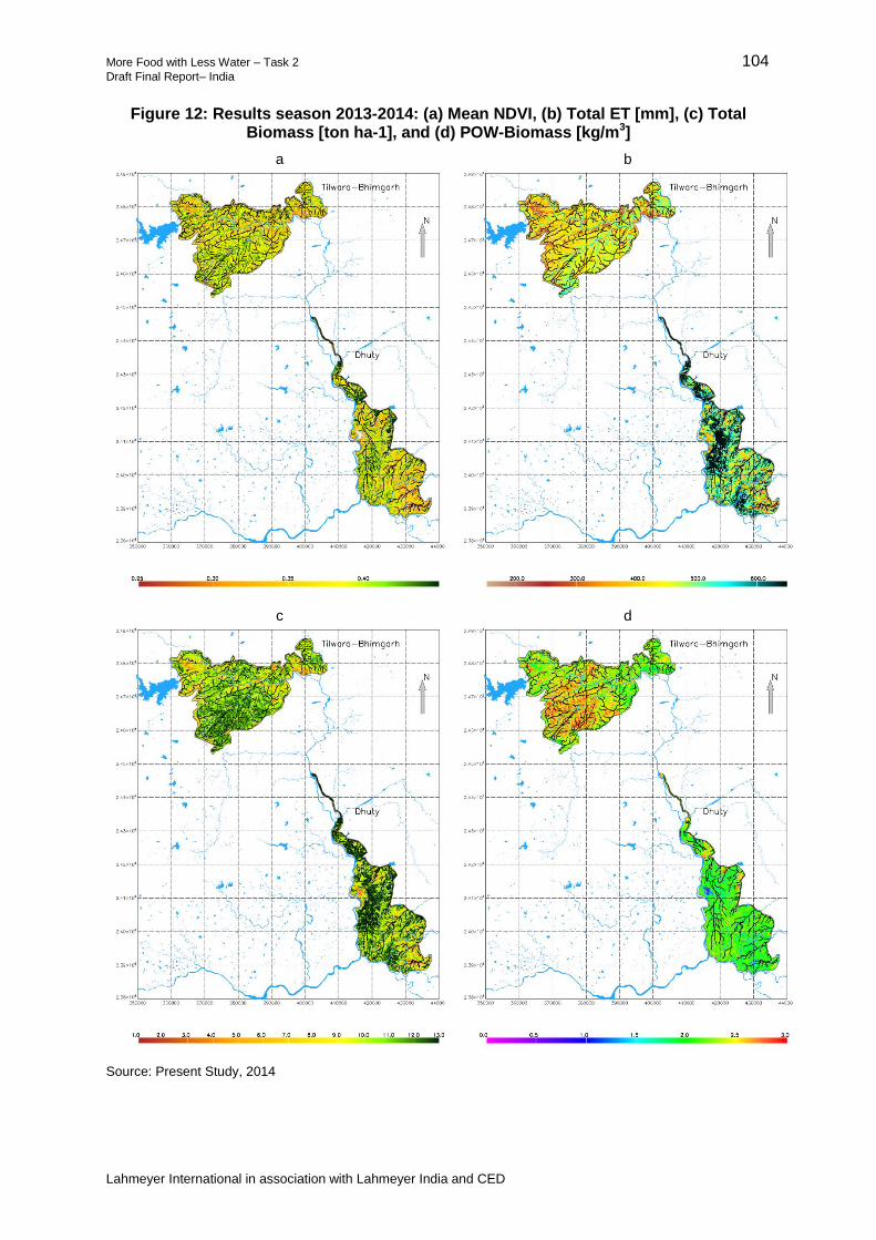
More Food with Less Water – Task 2 104 Draft Final Report– India
Lahmeyer International in association with Lahmeyer India and CED
Figure 12: Results season 2013-2014: (a) Mean NDVI, (b) Total ET [mm], (c) Total Biomass [ton ha-1], and (d) POW-Biomass [kg/m3]
a
b
c
d
Source: Present Study, 2014

More Food with Less Water – Task 2 105 Draft Final Report– India
Lahmeyer International in association with Lahmeyer India and CED
362. The analysis for the DS shows that POW of wheat is estimated to be 0.90 kg/m3 with an average yield of 3.05 ton/ha, which is in the low range of worldwide average water productivity of 0.6-1.9 kg/m3. For cotton (seed + lint) a mean POW is found of 0.9 kg/m3 (average yield 2.95 ton/ha). For fennel seed the mean POW is estimated to be 0.8 kg/m3 (average yield 2.5 ton/ha) and for castor oilseed 0.8 kg/m3 (average yield 3.95 ton/ha). However, it must be noted that the POW-values of cotton, fennel and castor are not absolute as part of the growing season was not included in the analysis. Due to the monsoon no useful images are available for the period June to October. The POW assessment revealed that the entire LBIA, and parts of RBIA (around Vadnagar and Visnagar, south and east of Vijapur and the area between Patan and Unjha) have the highest POW. These areas have the highest ET, total biomass production, yields and lowest ET deficits (<50 mm). The area west, north-west of Vijapur shows much lower ET-values, yields and crop-POW and the ET deficits are the highest. The spatial variation is presented in Figure 13. When comparing the actual water consumption with the potential water consumption in the command area, it was found that the area west, north-west of Vijapur shows much lower ET-values, yields and crop-POW and the ET deficits are the highest. This deficit indicates that there was a significant water shortage during the observed period and may have been a limiting factor for crop growth in that area, causing lower yields. Other limiting factors might have been low potential yield, management of the fields (i.e. nutrients and/or pest control, farming system), storm damage, etc. The total water consumption in LBIA for the period analyzed of 99.9 Mm3 (~6.4 Mm3/day) and 930.6 Mm3 (~5.8 Mm3/day) for RBIA (over the period November 1st, 2013 - April 10, 2014). Because no significant rainfall has been recorded during this period, it can be concluded that this water has been abstracted from the canal / river system and/or the ground water.

More Food with Less Water – Task 2 106 Draft Final Report– India
Lahmeyer International in association with Lahmeyer India and CED
Figure 13: Results season 2013-2014: (a) Mean NDVI, (b) Total ET [mm], (c) Total Biomass [ton ha-1], and (d) POW-Biomass [kg/m3]
Source: Present Study, 2014
B. Remote Sensing Monitoring and Management System
363. The MFLW analyses demonstrates that spatial variations of POW within a command area can be determined and visualized using remote sensing, thus enabling analysis and management applications to improve on POW. In this respect three applications specifically are of interest: (i) monitoring as an input to the planning for system modernization and management reforms, (ii) near-real time monitoring for operational management at the field level, and (iii) monitoring for evaluation and planning at the system level.
a b
c d
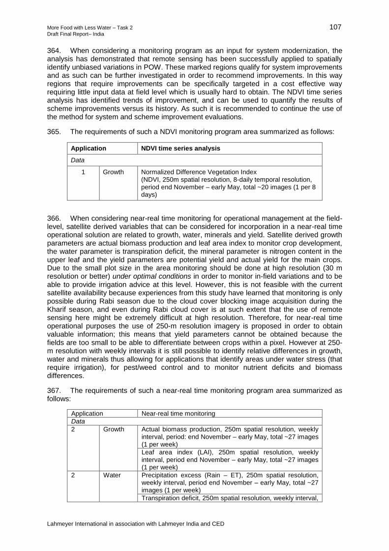
More Food with Less Water – Task 2 107 Draft Final Report– India
Lahmeyer International in association with Lahmeyer India and CED
364. When considering a monitoring program as an input for system modernization, the analysis has demonstrated that remote sensing has been successfully applied to spatially identify unbiased variations in POW. These marked regions qualify for system improvements and as such can be further investigated in order to recommend improvements. In this way regions that require improvements can be specifically targeted in a cost effective way requiring little input data at field level which is usually hard to obtain. The NDVI time series analysis has identified trends of improvement, and can be used to quantify the results of scheme improvements versus its history. As such it is recommended to continue the use of the method for system and scheme improvement evaluations.
365. The requirements of such a NDVI monitoring program area summarized as follows:
Application NDVI time series analysis
Data
1 Growth Normalized Difference Vegetation Index (NDVI, 250m spatial resolution, 8-daily temporal resolution, period end November – early May, total ~20 images (1 per 8 days)
366. When considering near-real time monitoring for operational management at the field-level, satellite derived variables that can be considered for incorporation in a near-real time operational solution are related to growth, water, minerals and yield. Satellite derived growth parameters are actual biomass production and leaf area index to monitor crop development, the water parameter is transpiration deficit, the mineral parameter is nitrogen content in the upper leaf and the yield parameters are potential yield and actual yield for the main crops. Due to the small plot size in the area monitoring should be done at high resolution (30 m resolution or better) under optimal conditions in order to monitor in-field variations and to be able to provide irrigation advice at this level. However, this is not feasible with the current satellite availability because experiences from this study have learned that monitoring is only possible during Rabi season due to the cloud cover blocking image acquisition during the Kharif season, and even during Rabi cloud cover is at such extent that the use of remote sensing here might be extremely difficult at high resolution. Therefore, for near-real time operational purposes the use of 250-m resolution imagery is proposed in order to obtain valuable information; this means that yield parameters cannot be obtained because the fields are too small to be able to differentiate between crops within a pixel. However at 250-m resolution with weekly intervals it is still possible to identify relative differences in growth, water and minerals thus allowing for applications that identify areas under water stress (that require irrigation), for pest/weed control and to monitor nutrient deficits and biomass differences.
367. The requirements of such a near-real time monitoring program area summarized as follows:
Application Near-real time monitoring
Data
2 Growth Actual biomass production, 250m spatial resolution, weekly interval, period: end November – early May, total ~27 images (1 per week)
Leaf area index (LAI), 250m spatial resolution, weekly interval, period end November – early May, total ~27 images (1 per week)
2 Water Precipitation excess (Rain – ET), 250m spatial resolution, weekly interval, period end November – early May, total ~27 images (1 per week)
Transpiration deficit, 250m spatial resolution, weekly interval,
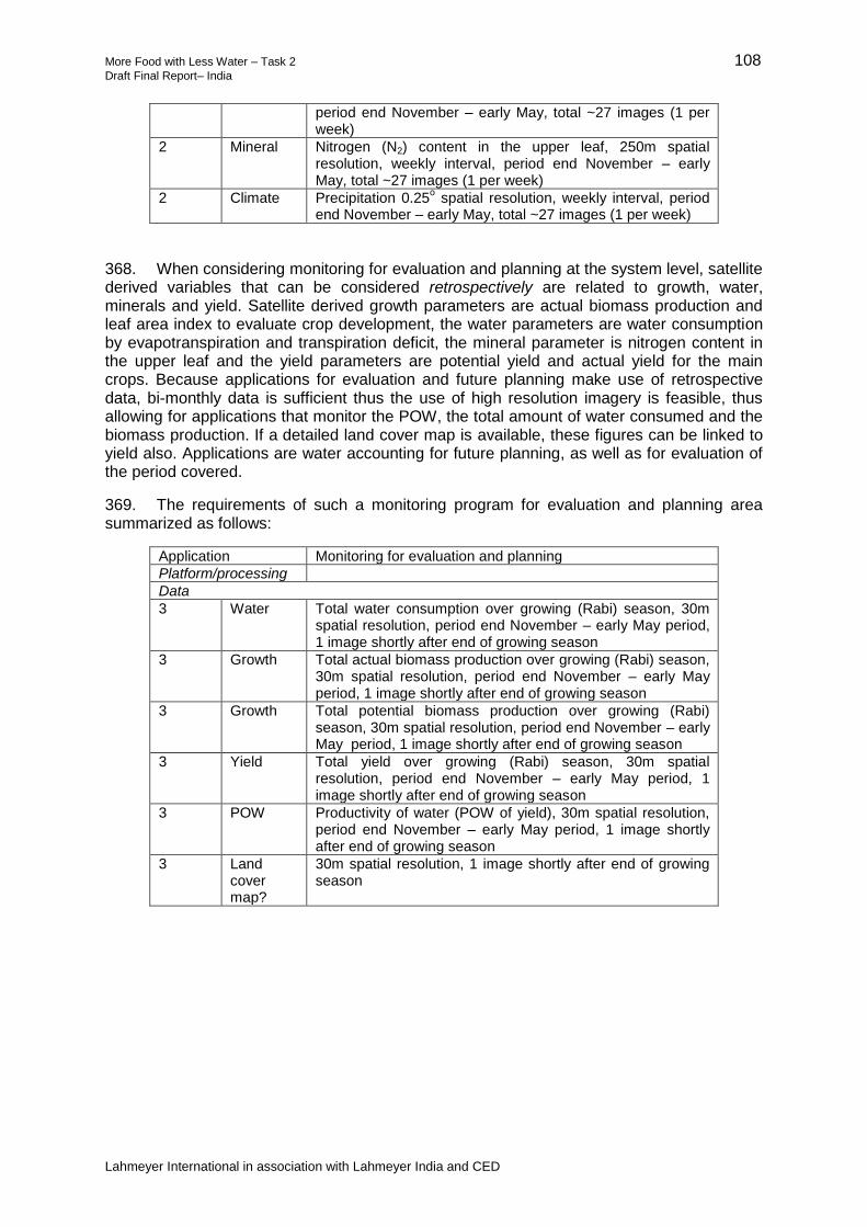
More Food with Less Water – Task 2 108 Draft Final Report– India
Lahmeyer International in association with Lahmeyer India and CED
period end November – early May, total ~27 images (1 per week)
2 Mineral Nitrogen (N2) content in the upper leaf, 250m spatial resolution, weekly interval, period end November – early May, total ~27 images (1 per week)
2 Climate Precipitation 0.25o spatial resolution, weekly interval, period
end November – early May, total ~27 images (1 per week)
368. When considering monitoring for evaluation and planning at the system level, satellite derived variables that can be considered retrospectively are related to growth, water, minerals and yield. Satellite derived growth parameters are actual biomass production and leaf area index to evaluate crop development, the water parameters are water consumption by evapotranspiration and transpiration deficit, the mineral parameter is nitrogen content in the upper leaf and the yield parameters are potential yield and actual yield for the main crops. Because applications for evaluation and future planning make use of retrospective data, bi-monthly data is sufficient thus the use of high resolution imagery is feasible, thus allowing for applications that monitor the POW, the total amount of water consumed and the biomass production. If a detailed land cover map is available, these figures can be linked to yield also. Applications are water accounting for future planning, as well as for evaluation of the period covered.
369. The requirements of such a monitoring program for evaluation and planning area summarized as follows:
Application Monitoring for evaluation and planning
Platform/processing
Data
3 Water Total water consumption over growing (Rabi) season, 30m spatial resolution, period end November – early May period, 1 image shortly after end of growing season
3 Growth Total actual biomass production over growing (Rabi) season, 30m spatial resolution, period end November – early May period, 1 image shortly after end of growing season
3 Growth Total potential biomass production over growing (Rabi) season, 30m spatial resolution, period end November – early May period, 1 image shortly after end of growing season
3 Yield Total yield over growing (Rabi) season, 30m spatial resolution, period end November – early May period, 1 image shortly after end of growing season
3 POW Productivity of water (POW of yield), 30m spatial resolution, period end November – early May period, 1 image shortly after end of growing season
3 Land cover map?
30m spatial resolution, 1 image shortly after end of growing season

More Food with Less Water – Task 2 109 Draft Final Report– India
Lahmeyer International in association with Lahmeyer India and CED
370. The most efficient and cost effective and thus recommendable way to incorporate remote sensing based applications for all three types of monitoring programs is by using a (internet) cloud based solution. This because of its ease of use, configurability and it can be obtained readily from third parties by subscription, thus not requiring large initial investments. The strength of such a service is that it can be configured as a ‘dashboard’ that contains different applications (or “apps”) for the different tasks and or/management levels and is therefore flexible and customisable for users. Applications in a dashboard can be obtained for free, per subscription or developed in-house with or without third party developers, thus fees are only applicable for the use of the service and the apps and/or data used. For example, some medium or low resolution satellite data can be obtained for free that can be used for some applications, while others might require purchased high resolution data. When using a dashboard the different apps will use the required data, thus overspending on resources can be avoided because it can be easily identified what the needs are. The applications to be made available to stakeholders do depend on the use and level of stakeholders. Since satellite derived maps on itself are data not containing information (eg, water deficit versus fields that require irrigation), it is recommended to offer applications, or “apps”, that can be defined during stakeholders consultations. Such apps can for example be water deficit applications that tells stakeholders what areas experience droughts or an SMS service that informs stakeholders per text message. An example of such dashboard is presented in Figure 14, showing an agricultural and water accounting dashboard and an irrigation planner. Because the service, apps and data are cloud based running on high speed servers, access at the different (field) offices and by smart phone if desired are possible. It is therefore recommended to further investigate the in use of such solution to further increase POW in the schemes.
Figure 14: Remote Sensing Dashboard and Monitoring Applications
More Food with Less Water – Task 2 110 Draft Final Report– India
Lahmeyer International in association with Lahmeyer India and CED
IX. SUMMARY AND CONCLUSIONS
A. Conclusions
371. The studies have prepared preliminary assessments for the modernization for the two major irrigation projects, the Dharoi (95,000ha) and Sanjay Sarovar (80,500ha). Both projects have restrictions on their water availability and high levels of groundwater are used to meet the shortfalls of surface water.
372. The immediate needs are to improve the levels of service delivery of the surface water systems, which require investments in the physical infrastructure as well as upgrading of the irrigation management both at the project level and also the WUA. This requirement to improve the surface water delivery systems is critical and is the priority for both projects.
373. In the DIP surface water provides around 23% and SSIP 44% of the irrigation requirement and clearly tackling the surface water systems alone cannot fully meet the needs of long-term and sustainable irrigation.
374. Over and above the problems of the surface water systems, the studies have identified significant constraints to the long-term water use efficiency and productivity of water, and to the sustainability of the two schemes, which are outside the scope of surface water management systems; these include the lack of integrated surface and groundwater management, over exploitation and lack of sustainable groundwater, the lack of support and weakness of the WUA who have no control on groundwater, high levels of dissatisfaction, poor opportunities and returns by farmers in agriculture, heavy levels of power consumption based on financially unsustainable charging systems. The complexity of the large scale irrigation schemes and the variable performance of Participatory Irrigation Management (PIM) to tackle the wide ranging problems is now internationally documented.
375. Currently there is no organization with the remit and capacity to tackle all these issues which are technical, institutional, social and political. The scale of the issues poses enormous challenges that are clearly outside the current capacity and remit of the WRD or the WUA. From the MFLW studies and confirmed by the many discussions with the farmers, officers and other stakeholders, there is however an urgent need as well as a high degree of support and willingness to move forward to resolve the many problems and to develop long-term integrated and sustainable irrigation management systems.
376. The study presents proposals for the development of integrated management of the surface water, groundwater, power, and agriculture and introduction of modern irrigation technologies including SCADA, micro irrigation, electrification and pre-paid metering into the management of the two pilot projects. Technically these are all implementable, but the lack of an strong and integrated organization to proactively tackle and mainstream cross cutting issues across multiple sectors is a fundamental requirement. The other key requirement is how to ensure long-term financial sustainability including resources and funding for effective management, operation and maintenance.
377. Alternative management strategies need to be explored and developed in consultation with WRD and the stakeholders. In both projects there is some scope to increase staff capacities within the WRD as well as the WUAs through training and capacity-building; however, the benchmarking and institutional studies indicate that significant increase in capacities and development of new strategies, policies and institutional reforms will be required.
378. The study has identified the need to develop dialogue and partnerships with the private sector to complement the government resources. For some necessary functions strengthened management can be effectively provided throu

More Food with Less Water – Task 2 111 Draft Final Report– India
Lahmeyer International in association with Lahmeyer India and CED
379. gh outsourcing some management functions to the private sector through management contracts and, in the short-term, this is the recommended strategy. For the longer term, alternative approaches include: (i) the establishment of an Integrated Irrigation Authority; or (ii) the introduction of private sector management through concessions or long-term leases as is practiced in other parts of the world. In both cases the reformed organization would require the remit and financial incentives to achieve efficient, sustainable and self-financed irrigation management. The irrigation authority or private operator would work through the WRD and selected government staff could be seconded to the management organization which would have autonomy and flexibility to develop the necessary levels of management including the requirements for integrated surface, groundwater, power and agriculture management as well as operation and maintenance cost recovery for the two pilot schemes.
380. The irrigation studies in Sikkim identified the need to improve the planning and designs including obtaining better information on stream flows and cropping patterns. Farmers were found to be less interested in planting during the Rabi period due to the low returns and the uncertainties of the water supply. The potential to use piped distribution systems and micro irrigation to promote rabi irrigation needs to be further investigated.
B. Summary of innovations
381. The MFLW study has conducted an assessment of the current irrigation in the DIP in Gujarat and the SSIP in Madhya Pradesh . The studies have been conducted in three parts.
(i) Part 1: Assessment and Benchmarking which has been based on the FAO Rapid Appraisal Process (RAP) complemented by extensive consultations with stakeholders and detailed examinations of sample areas through the diagnostic performance evaluations. Remote sensing has also been carried out.
(ii) Part 2: Institutional and Technical Studies; these have built on Part 1 and have included an assessment of the requirements for the upgrading and modernization of the irrigation systems in the two pilot projects including; surface water, groundwater, agriculture and institutions. The studies have also looked at the energy needs for pumping of groundwater and micro irrigation.
(iii) Part 3: Planning for Modernization which has included preliminary costing and packaging of the various options, agriculture and institutional planning, as well as an initial economic and financial analysis.
382. The MFLW study is designed to support the application of innovative water efficient technologies and management systems that can be used for irrigation planning and design. For the two pilot irrigation projects, the seven main innovations developed from the study are summarized in Table 27.
Table 27: Summary of Innovations
Aspect Description
1. Innovative analytical tools for diagnosis and planning for modernization of large-scale irrigation schemes.
Integrated approaches for diagnosis and participative planning of irrigation including surface and groundwater, agriculture, and institutions have been developed.
2. Modernization of the Planning for upgrading and modernization of two large irrigation schemes to achieve high levels of water use

More Food with Less Water – Task 2 112 Draft Final Report– India
Lahmeyer International in association with Lahmeyer India and CED
Aspect Description
Irrigation Systems efficiency, including the establishment of flow measurement, use of long crested weirs, balancing reservoirs, and development of modern water management including SCADA.
3.Conjunctive Development of Surface and Groundwater
Both irrigation schemes are heavily reliant on groundwater. Currently the schemes are managed based on the surface water systems with minimal consideration of groundwater. Discussion with stakeholders including the WUAs indicated the need to move towards integrated management of surface and groundwater; both systems are interdependent. New initiatives to incorporate surface and ground water management are proposed with potentials to improve water availabilities.
4. Development of Piped Distribution and Micro Irrigation
The studies have examined the potential to introduce micro irrigation using surface and groundwater sources with benefits of higher efficiencies and improved yields. The development of micro irrigation using both surface and groundwater has been identified as a mechanism towards sustainability by bridging the surface and ground water management gap.
Investment in piped and micro irrigation by gravity in the hill areas of Sikkim offers potentially good opportunities to improve water use efficiency and expand the dry season irrigation areas where irrigation supplies are very scarce; feasibility studies are required to assess farmer interest and the financial viability.
6.Outsourcing of management functions and establishment of long term self financing irrigation management organizations.
Current institutional capacities and resources are insufficient to meet the needs of integrated irrigation management including surface and groundwater management.
To meet the gap, it is proposed to initially outsource some management functions to a third-party operator through a management contract. The new organization would work with existing WRD staff and the WUAs to establish effective and efficient management including establishing sustainable systems of cost recovery.
For the long-term, efficient self-financing management needs to be established. The initial management contract would develop arrangements, necessary reforms and support the transition for long term management, operation and maintenance. Options for long-term management include establishment of an Autonomous Irrigation Management Authority or a long-term lease through a PPP contract.