Embed Size (px)
Citation preview

June 9, 2016 GeoInsight Project 7877-000 Page 1
One Monarch Drive, Suite 201 Littleton, Massachusetts 01460
Tel. (978) 679-1600 Fax (978) 679-1601
TECHNICAL MEMORANDUM
MELONE PROPERTY NORTH ROAD
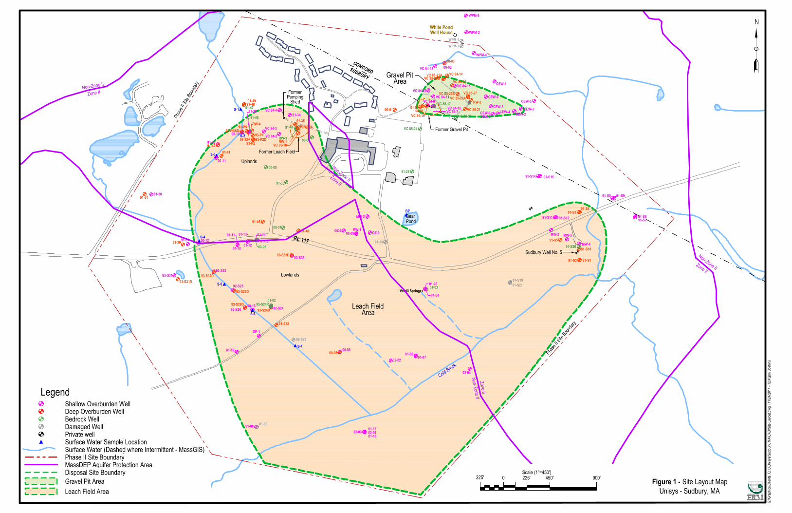
SUDBURY, MASSACHUSETTS INTRODUCTION GeoInsight, Inc. (GeoInsight) was retained by the Town of Sudbury (Town) to conduct an environmental data review associated with the Melone Property (Property) located on North Road in Sudbury, Massachusetts. It is our understanding that the Town acquired the approximately 46.6-acre Property in 1990. The properties to the west and northwest are the location of the former Sperry Rand/Unisys facility which is a documented Commonwealth of Massachusetts hazardous materials release site (the disposal site has historically been identified as the Former Sperry Research Center. For ease of reference, and to use nomenclature that is most familiar to the local community, we will refer to the Former Sperry Research Center site as the Sperry/Unisys Site in this memorandum. Historical releases of the chlorinated degreasing solvents trichloroethene (TCE) and tetrachlorethene (PCE) at the Sperry/Unisys Site resulted in the formation of two plumes of chlorinated volatile organic compounds (CVOCs) in groundwater that have migrated onto and beneath adjacent properties to the south and east. Sperry Corporation was identified by the Massachusetts Department of Environmental Protection (MADEP) as the responsible party for these conditions. MADEP assigned Release Tracking Number (RTN) 3-0435 to the release condition. Since 1984 Sperry Corporation, and then subsequently Unisys Corporation (created when Sperry Corporation was sold in 1986), have been responsible for performing environmental characterization and remedial activities under the Massachusetts Contingency Plan (MCP). The Melone Property is located directly adjacent to the original Sperry/Unisys Site holdings, which were subsequently subdivided and developed. GeoInsight understands that the Town is considering reuse options for the Property. GeoInsight prepared this Technical Memorandum to provide the Town with a general summary of the Sperry/Unisys Site, including a summary of constituents of concern (COCs) released, environmental media and areas impacted, and remedial activities (former, current, and future).
June 9, 2016 GeoInsight Project 7877-000 Page 2
Historical information presented in this Technical Memorandum was obtained from a review of historical and recent environmental reports prepared by others and previously submitted to the MADEP, and certain documents obtained from the Sudbury Water District and the Town of Concord. GENERAL SUMMARY OF THE SPERRY RAND/UNISYS SITE The former Sperry Research Center was located on an approximately 140-acre property located at 100 North Road in Sudbury, Massachusetts. The Sperry Research Center utilized the property for research and development of electronic systems and subassemblies from the early 1960s until December 1983. Prior to development in 1959, the property was occupied by a horse farm. In 1984, environmental investigations conducted to support a potential sale of the property resulted in the discovery of releases of TCE to groundwater. In September of 1986, Burroughs Corporation acquired Sperry Corporation, forming Unisys Corporation (Unisys). Releases of TCE to groundwater were discovered in two primary source areas: the Leach Field and Gravel Pit Areas (which currently comprise the “disposal site” under the MCP). The source of CVOCs in the Leach Field Area include the former sanitary leach field system and former Chemical Neutralization System (CNS) associated with the Sperry Research Center facility. The CNS tanks and associated discharge piping were removed in 1984. The source of CVOCs in the Gravel Pit Area is believed to have been periodic or sporadic dumping of spent chemicals. The locations of pertinent Site features are presented on Figure 1 (obtained from the Environmental Resources Management [ERM] Combined Temporary Solution Status Report #12 for the Gravel Pit & Leach Field Areas dated December 4, 2015). The Site is located within mapped Public Water Supply Zone II boundaries (i.e., that area of an aquifer which contributes water to a well under the most severe pumping and recharge conditions that can be realistically anticipated) for the Sudbury Water District Well No.5 and the Town of Concord’s White Pond wellfield. A Zone II is considered a Current Drinking Water Source Area under the MCP, and releases of hazardous materials with a Zone II must be remediated to drinking water standards to achieve regulatory closure. Leach Field Area Groundwater Plume Based upon the results of historical characterization activities, the areas of groundwater impacts associated with the Leach Field Area was divided into two portions identified as the Leach Field Uplands and the Leach Field Lowlands. The Leach Field Uplands Area is defined as the topographically higher elevations north of Route 117 and hydrogeologically represent groundwater recharge areas. Releases to the Leach Field Uplands Area migrated downward and to the southwest in the general direction of groundwater flow in the overburden, and portions of the plume discharged to the unnamed stream located to the west of the leach field. A portion of the plume also migrated vertically downward and entered the underlying bedrock.

June 9, 2016 GeoInsight Project 7877-000 Page 3
The bedrock portion of the Leach Field Area plume migrated to the south toward the regional topographic low and area of groundwater discharge near Cold Brook. The plume eventually migrated vertically upward and discharged into the overburden within the low lying area to the south of North Road. This upward migration of the plume out of bedrock and into the overlying soils created a second area of CVOC impacts in overburden groundwater associated with the Leach Field Area source area. This area of impacts was referred to as the Leach Field Lowland Area/portion of the plume. The Leach Field Lowland Area consists primarily of agricultural land. Impacts in the Leach Field Lowland Area were observed to be widespread, and the areas of impacts extended south beyond Cold Brook, and to the east toward Well No.5. Leach Field Area Remedial Actions The initial remediation system installed in the Leach Field Area operated from 1986 through 1994. A single overburden ground-water recovery well (RW-1) was installed and pumped at rates that varied from 1 to 5 gallons per minute (gpm). Groundwater from RW-1 was treated using a packed tower air stripper and the effluent water was discharged locally. The remediation system was upgraded in 1993 to 1994 to increase the area from which impacted groundwater was captured. Two additional recovery wells were installed, an overburden recovery well (RW-4) and a bedrock recovery well (RW-3). RW-3 was installed approximately 20 feet to the west of RW-1 as an open-hole bedrock well to a depth of 300 feet. RW-4 was completed approximately 450 feet west of RW-1 as an overburden recovery well to a depth of 68 feet. In 1994, the initial treatment system was dismantled and the three recovery wells were connected to a new treatment building. Groundwater from each recovery well was treated using a low profile tray air stripper that had a maximum design flow rate of 22 gpm. Treated groundwater was discharged to a nearby wetland that ultimately discharges to an unnamed tributary of Cold Brook. The groundwater recovery/treatment system operated under “Phase IV Operation and Maintenance” until 2002 when it was determined that further operation was not beneficial to plume reduction or containment; historical groundwater monitoring activities had documented that the primary CVOC mass associated with the plume had migrated beyond the influence of the recovery system. Gravel Pit Area Groundwater Plume The Gravel Pit portion of the Sperry Rand/Unisys Site is located in a topographic depression located approximately 600 feet northeast of the former SRC facility and within 50 to 100 feet of the northwestern corner of the Melone Property. The area may have been historically used as a gravel pit, or it may have been a natural topographic depression. Elevated concentrations of PCE and TCE were detected in samples of groundwater collected from monitoring wells located within the middle and to the east of the gravel pit depression. The impacts did not appear to extend into the underlying bedrock. Soils in the Gravel Pit Area consisted of approximately 20 to 40 feet of sand and gravel underlain by 5 to 15 feet of glacial till. Bedrock slopes downward to the north and east and is approximately 30 feet deep in the vicinity of the gravel pit and 50 feet deep in the wetlands that are located to the east.

June 9, 2016 GeoInsight Project 7877-000 Page 4
Groundwater impacts associated with the Gravel Pit Area plume consisted primarily of PCE and TCE. The plume extended approximately 900 feet to the east in the overburden sand and gravel, and at one time may have discharged to the wetlands located along an intermittent stream that occupies the associated lowland area.
Gravel Pit Area Remedial Actions
The initial remediation system installed in the Gravel Pit Area was operated from 1986 through 1994. A single overburden groundwater recovery well (RW-2) was installed downslope from the gravel pit and pumped at rates ranging from 30 to 90 gpm. Groundwater from RW-2 was treated using a packed tower air stripper and discharged to a nearby wetland that ultimately discharges to an unnamed tributary of Cold Brook. From 1986 to 1990, approximately 5 gpm of the treated groundwater was pumped uphill to the gravel pit and discharged at the surface to promote flushing of the CVOCs from the soil in the suspected source area.
In 1993, alterations were made to the Gravel Pit Area remedial system to expedite the removal of CVOCs. A groundwater interceptor trench approximately 130 feet in length, 4 feet in width, and 30 feet in depth was excavated in the Gravel Pit Area. The trench was graded from northwest to southeast so that groundwater drained to a 20-inch diameter sump.
In 1994, a new treatment building was constructed in the Gravel Pit Area. Groundwater recovered from RW-2 and the interceptor trench sump was treated using a packed tower air stripper. Treated groundwater was discharged to a wetland that ultimately discharged to Cold Brook.
The treatment system operated until 1999, at which time the system was shutdown, when it was determined to be no longer effective in further reducing TCE or PCE concentrations in groundwater, or necessary to control migration.
In May 2001, Release Abatement Measure (RAM) activities conducted at the Gravel Pit Area consisted of the injection of sodium permanganate in May 2001, and the excavation of approximately 100 tons of PCE- and TCE-impacted source area soil in March 2004. Groundwater quality conditions in the vicinity of the gravel pit improved markedly after the PCE- and TCE-impacted soil was excavated as part of the RAM.
Regulatory Status
On December 10, 2014, a Revised Summary Temporary Solution Statement was submitted to MADEP that encompasses the Gravel Pit and Leach Field Areas. The disposal site boundaries of the Gravel Pit and Leach Field Areas are depicted on Figure 1.
A Temporary Solution indicates that each source of CVOCs at the Sperry/Unisys Site has been eliminated, controlled, or mitigated to the extent feasible, and that No Substantial Hazard to human health, safety, public welfare or the environment under current and foreseeable future conditions has been achieved. A Permanent Solution is not currently attainable because the

June 9, 2016 GeoInsight Project 7877-000 Page 5
concentrations of CVOCs in groundwater exceed applicable Commonwealth of Massachusetts drinking water standards, and both areas are located within mapped Zone II areas for municipal water supplies.
Post-Temporary Solution Status Reports are filed every six (6) months to document the results of monitoring activities and update information regarding land use and potential exposure pathways.
Post-Temporary Solution groundwater monitoring for the Leach Field Area includes biennial sampling of selected monitoring wells to monitor continued natural attenuation of CVOCs in groundwater. Post-Temporary Solution groundwater monitoring for the Gravel Pit Area includes annual groundwater sampling (of one monitoring well) and biennial (every other year) monitoring of selected monitoring wells.
Current COCs (October 2015) within the Leach Field Area plume include primarily TCE and cis-1,2-dichloroethene (cDCE) and to a lesser extent (i.e., generally detected infrequently and at low concentrations) trans-1,2-dichloroethene (tDCE), benzene, and 1,2-dichlorobenzene. According to information provided in ERM’s Combined Temporary Solution Status Report #12, dated December 4, 2015, concentrations of CVOCs are mostly consistent with previous sampling rounds and generally show decreasing concentrations of CVOCs.
After the RAM soil excavation activities were completed, historical monitoring has documented the attenuation and shrinking of the Gravel Pit Area plume over time. Groundwater impacts at concentrations above applicable risk and drinking water standards is currently only present in a localized area near the original source of the Gravel Pit Area plume. The most recent concentrations of CVOCs at this location only slightly exceed applicable standards, and are expected to continue to attenuate over time.
Sperry/Unisys Site - Relevant Data Gaps
Based upon our focused review of historical environmental documents, we identified the following significant data gaps with regard to conditions at the Sperry/Unisys Site and impacts to the Melone Property and possible property re-use considerations.
• the southern and southeasterly extent of the Gravel Pit Area plume was not historicallydelineated, including possible migration in deep overburden and shallow bedrock.Remedial actions appear to have resulted in the attenuation of and shrinking of the plumeover time, such that CVOCs no longer appear to be migrating from the source area intodowngradient areas.
• the specific source(s) and migration pathways for TCE present at Well No.5 were notidentified and fully characterized. Some of the impacts appear to be attributable to theeasterly migration of the Leach Field Lowland Area plume under hydraulic influencesassociated with the operation of Well No.5. It is uncertain whether similar hydraulic

June 9, 2016 GeoInsight Project 7877-000 Page 6
influence could have also pulled the leading portion of the Gravel Pit Area plume southward toward the well, and resulted in the TCE impacts detected to the north of North Road.
• the source(s) and extent of TCE impacts near the southwest corner of the Melone
Property have not been characterized. Impacts associated with this location may be pulled onto the Melone Property during the period that Well No.5 is operational.
• the north boundary of the eastern portion of the Leach Field Lowland Area plume as currently mapped across the approximately 2,000-foot width of the Melone Property is estimated and not based upon field data. Without property-specific sampling data, it is possible that the plume extends further north onto the property. It is also possible that the plume does not extend onto the south part of the Melone Property along North Road (i.e., the plume is not located on the north side of North Road).
MELONE PROPERTY INFORMATION General Property Description The Melone Property (Property) is a 46.6-acre, irregularly-shaped property located on the north side of North Road (Route 117) in Sudbury, Massachusetts. Currently, 9.9 acres of land that comprise the southwest portion of the Property are set aside for conservation. The central and southern portions of the Property consist of 20.3 acres of land that have historically been mined for gravel. The northeast portion of the Property consists of 16.4 acres of land that is located in the Town of Concord, much of which is occupied by wetland and lowland areas. A copy of the Town GIS Map depicting the Melone Property is attached. Topography at the Property has been altered significantly by gravel mining operations. Historically and regionally, the topography generally slopes downward to the east and south into flat lying low areas on the south side of North Road and areas to the east and southeast in Concord. The land surface elevation in the central and southern portions of the Property (approximately 28 acres) has been reduced or lowered by approximately 30 or more feet as a result of gravel mining operations. The central portion of the Property consists of a relatively flat low-lying, gravel pit area. The flat lying area is bordered by relatively steep upward slopes to the adjacent un-mined land. Property abutters include: To the north:
• undeveloped woodland and wetland areas located within the Town of Concord. To the west:
• Northwood, a 12.4-acre parcel that used to be part of the Sperry Rand/Unisys property
that was redeveloped in the early 2000s into a multi-unit senior housing complex.

June 9, 2016 GeoInsight Project 7877-000 Page 7
• the Sperry/Unisys Site, which was subdivided and redeveloped as multi-use residential (Frost Farm) and commercial properties.
To the south:
• on the north side of North Road, by the approximately 1.0-acre, rectangular Wagner residential property.
• on the south side of North Road, by agricultural fields, and undeveloped land occupied by Sudbury No.5 water supply well.
To the east and southeast:
• a 6.87-acre undeveloped parcel that is owned by the Sudbury Water District and currently occupied by a cellphone tower.
• undeveloped wetland and woodland areas. Historically, the Property appears to have been used for agricultural and then gravel mining purposes. Aerial photographs indicate that an orchard covered the approximate western half of the Property from at least 1938 to approximately 1957, after which time the orchards appear to have been in decline. Gravel mining operations appear to have commenced in the central portion of the Property (directly north of North Road) between 1952 and 1957. Larger scale gravel mining began in the eastern portion of the Property in approximately 1969. Gravel mining operations have removed soil from the approximately eastern half of the area that was historically occupied by the orchard. The portion of the Property currently located to the west of the gravel mining area are undisturbed areas that were once occupied by orchards. Review of historical aerial photographs indicated that from the late 1970s to the early 1990s, the portion of the Property directly northwest of the Wagner property was occupied by miscellaneous vehicles. According to a 1992 Preliminary Environmental Site Assessment Report for the Property by Woodard & Curran, Inc. (Woodard & Curran), Mr. Wagner removed 35 cars from that portion of the Property sometime after May 1991. The vehicles are gone as of a 1994 aerial photograph. The area where the vehicles were located was subsequently mined for gravel. The Woodard & Curran report also included the analytical results of six soil samples collected by a representative of the Sudbury Board of Health at the Property in 1991. The samples were collected at one location in the southern portion of the Property (SS-1) and at two locations near the Sudbury/Concord Town line in the northern portion of the Property (SS-2 and SS-3). Locations SS-1 and SS-3 are within the area of the Property that was once occupied by orchards. Location SS-2 was located east of the historical orchard and the area was subsequently mined for gravel.
June 9, 2016 GeoInsight Project 7877-000 Page 8
At the three locations soil samples were collected from 2 to 6 inches and 6 to 12 inches bgs and analyzed for the Resource Conservation and Recovery Act (RCRA) eight metals. Metals concentrations at locations SS-2 and SS-3 were consistent with background/natural soil. Slightly elevated concentrations of lead and arsenic (above MADEP Identified Background Levels in Soil, MADEP, 2002) were detected in the soil samples collected from location SS-1. Arsenic was detected at concentrations of 34.1 and 34.2 parts per million (ppm), and the MADEP background concentration for natural soils is 20 ppm. Lead was detected at concentrations of 112.5 and 131.2 and the MADEP background concentration is 100 ppm. The concentrations of arsenic and lead that were detected in the samples from location SS-1 are within the range of concentrations observed in natural soils, and may be attributable to local variability. The presence of these metals in soil may also be attributable to the historical use of pesticides/herbicides within the former orchard. Environmental Database Review GeoInsight performed an initial screening of various regulatory databases using an Environmental Data Resources, Inc. (EDR) Radius Map Report dated January 4, 2016. The EDR report provides information regarding the use and storage of oil and hazardous materials (OHM) and releases of OHM to the environment that were identified in their search of federal and state databases. The EDR report was used to identify records and information pertinent to evaluating the possible presence of environmental conditions that could affect the Property. The database review included neighboring properties, with particular attention being paid to those properties upgradient or cross-gradient with significant environmental records, if applicable. The EDR database review identified four state-listed hazardous waste sites and one Leaking Above Ground Storage Tank (LAST) site located within approximately one mile of the Property. The Sperry Research Center was listed on both the Environmental Response, Compensation and Liability Information System (CERCLIS) and as a State-listed hazardous waste site (for RTNs 3-0435 and 3-21667). RTN 3-21667 is associated with the detection of metals (specifically beryllium and nickel) in soil samples collected from an excavation trench along the remaining pipe sections of the former Chemical Neutralization System and sanitary wastewater system. Impacts to groundwater were not identified. A Method 3 Risk Characterization demonstrated that the metals in soil did not pose a significant risk of harm to human health, safety, public welfare, or the environment. No remedial response actions were conducted in response to this release condition. A Class B-1 RAO was submitted to MADEP on March 3, 2003 for RTN 3-21667. The remaining two state-listed hazardous waste sites and the LAST site are greater than 0.25 miles from the Property and are not anticipated to adversely impact environmental conditions at the Property based upon their distance from the Property and the types and quantity of OHM released.
June 9, 2016 GeoInsight Project 7877-000 Page 9
Potential Impacts From Off-Property Sources Groundwater conditions, both physical (depth to groundwater and direction of flow) and chemical, have not been evaluated on the Property. Limited groundwater characterization data are available on adjacent properties near the north Property boundary, near the southwest Property corner, and on the Sudbury Water District property to the east. The central portion of the Property does not appear to be directly downgradient of the Leach Field and Gravel Pit source areas of the Sperry Rand/Unisys Site. Portions of the Gravel Pit Area plume were present along the north boundary of the Property, and historically extended to the east onto a limited area of the Concord/wetland portion of the Property. Additionally, groundwater impacts associated with the Leach Field Lowland Area plume were present along the south portion of the Property along North Road. Historically, pumping of Sudbury Well No.5 may have pulled portions of the Leach Field Area Lowland plume onto the south portion of the Property. Several monitoring wells identified as the “CEW” series were installed (prior to 1991) in wetland area just north of the Property to assess groundwater conditions associated with the Gravel Pit Area. Groundwater analytical data from 1991 indicate that generally low concentrations of CVOCs (including TCE) were detected in several of the CEW wells located near the Property boundary. These impacts were not further characterized, and the CEW wells do not appear to have been sampled since 1991. TCE has consistently been detected in samples of shallow and deep overburden groundwater in monitoring wells located approximately 200 feet west of the southwest corner of the Property (i.e., near the entrance to the Northwood property). Groundwater impacts at this location (wells MW-1 and 02-05) are not readily connected to the known overburden impacts near the Leach Field and Gravel Pit source areas, or the Leach Field Lowland Area plume that is located south of North Road (i.e., well 91-S22 area). Similarly, TCE has been detected in samples of overburden groundwater on the Wagner property and the Sudbury Water District property to the east, and in overburden and shallow bedrock near Well No.5. TCE has also been detected in overburden groundwater between Well No.5 and the Leach Field Lowland Area plume to the west. Historical operation of Well No.5 may have pulled the southern portion of the plume eastward toward the well. However, this potential pulling of the southern portion of the Leach Field Lowland Area plume to the well does not explain the presence of TCE in overburden groundwater several hundred feet north of Well No.5 (on the north side of North Road), or within shallow bedrock at Well No.5. Several historical researchers suggested that the TCE impacts at Well No.5 may be attributable to the Gravel Pit Area plume. This possibility was never fully evaluated. Were this to have occurred, the Gravel Pit Area plume would have had to extend across the northeast/Concord portion of the Property.

June 9, 2016 GeoInsight Project 7877-000 Page 10
WATER SUPPLY INFORMATION Portions of the Property and the Sperry/Unisys Site are located within Zone II areas for the Sudbury Water District Well No.5 and the Town of Concord White Pond wellfield. Zone IIs are considered the geographic areas that would be expected to typically provide water to a municipal well under most pumping situations. For this reason, Zone II areas are considered environmentally sensitive, and they receive increased attention and protection with regard to land uses that could adversely impact groundwater quality. The Zone II area for Well No.5 extends northward across North Road across the entire Property, northward to the approximate location of the White Pond wellfield. The Zone II includes the Gravel Pit Area, and also extends to the west toward the Leach Field Lowland Area of the Sperry/Unisys Site. The Zone II area for the White Pond wellfield extends southward to the north border of the Property, and includes that Gravel Pit Area of the Sperry/Unisys Site. The White Pond wellfield Zone II also extends southwesterly to include the Leach Field Upland Area of the Sperry/Unisys Site. The Zone II area for the White Pond wellfield does not extend southward onto the main/central portion of the Property. Sudbury Water District – Well No.5 Sudbury Water District Well No.5 is located approximately 575 feet southeast of the southeast corner of the Melone Property. The well is 65 feet deep and is located in the lower portion of the sand and gravel overburden soils. The well was installed in 1964. In the late 1980s, TCE was detected in samples of water obtained from Well No.5 and the well was shut down. In 1991, an air stripper treatment system was installed to remove the TCE and other volatile organic compounds that may be present, and Well No.5 was reactivated. During the early 2000s, Well No.5 was operated seasonally during peak demand during the summer months (May/June to September/October). The well typically operated at a rate of 350 to 460 gpm, and on average supplied approximately 50 million gallons of water annually. Well No.5 was shut down in 2009 because of water quality issues associated with the presence of iron and manganese. Since 2009, the Sudbury Water District has performed the required sampling to maintain Well No.5’s active status (thus insuring that the well could be used in the future if needed). Considerations:
• Historical groundwater characterization data associated with the Sperry/Unisys Site groundwater plumes were obtained during the period that Well No.5 was operational. Hydraulic conditions in the vicinity of Well No.5 have likely changed since use of the well was discontinued in 2009. The change in hydraulic conditions has likely impacted the movement of the Leach Field Lowland Area plume.

June 9, 2016 GeoInsight Project 7877-000 Page 11
• When operating, Well No.5 likely draws water from the east, southern, and central portions of the Property and from the historical footprint of the Leach Field Lowland Area plume.
Town of Concord – White Pond Wellfield The Town of Concord White Pond wellfield is located approximately 900 feet north of the north border of the Melone Property. The White Pond well is 64 feet deep and is located in the lower portion of the sand and gravel overburden soils. The well was installed in 1970. During the 1990s and early 2000s, the White Pond wellfield was operated seasonally during peak demand during the summer months (generally May/June to September/October). The well typically operated at a rate of 330 to 450 gpm, and on average supplied approximately 60 million gallons of water annually. Water from the White Pond well historically contained low to moderate concentrations of iron and manganese. The concentrations of these metals would increase each year toward the end of the summer. In an attempt to improve the quality of water from the well, in 1999 the Town of Concord installed two shallow satellite wells near the White Pond well. The satellite wells were installed 50 feet north and 50 feet south of the existing well, and were placed at a depth of 40 feet. Field investigations had suggested that shallow groundwater in the vicinity of the White Pond Well contained lower concentrations of iron and manganese. The three wells were piped together (and referred to as the White Pond wellfield) and operated concurrently at a combined rate that was similar to the historical White Pond Well rate. Use of the satellite wells did not significantly improve the water quality with regard to iron and manganese. In November 1999, the Gravel Pit Area treatment system was shutdown to facilitate the collection of hydrogeologic data during a pumping test conducted by the Town of Concord on the White Pond Well. The pumping test was completed in June 2000. Results of the pumping test indicated that a measured drawdown response was not detected in any of the monitoring wells in the Gravel Pit Area. These data suggested a low potential for residual groundwater impact in the Gravel Pit Area to adversely impact the White Pond Well during then-current pumping rates. In 2008, the Town of Concord connected the White Pond wellfield to the newly constructed Deaconess Water Treatment facility, which includes treatment for iron and manganese. Since 2008, the White Pond wellfield has operated year round. The White Pond wellfield typically operates at a rate of 150 to 280 gpm, and on average supplies approximately 120 million gallons of water annually. Considerations:
• Prior to 2008, when the White Pond wellfield was operated seasonally, most of the groundwater flow came from the north, from the White Pond area.
June 9, 2016 GeoInsight Project 7877-000 Page 12
• Data collected in 1999/2000, when the White Pond well operated seasonally, indicated that the well did not likely induce overburden water flow from the Gravel Pit Area to the well. It is unclear what effect the increased well use has on groundwater flow patterns in the vicinity of the Gravel Pit Area, and, if there is a potential for migration of groundwater from the north portion of the Property as a result of the increased use of the White Pond wellfield.
• The main/central portion of the Property is not located within the Zone II area for the White Pond wellfield.
REDEVELOPMENT CONSIDERATIONS Based upon information obtained during our focused review of conditions associated with the Sperry/Unisys Site, and information regarding local water supplies, we identified the following possible environmental considerations associated with future redevelopment of the Melone Property. Soil Related:
• Much of the soil over the central and east portion of the Melone Property was mined for gravel. Consequently, the soil that is currently located at the ground surface is comprised of deeper native soil that is not expected to have been impacted by historical uses of the Property.
• The non-gravel-mined west portion of the Melone Property was historically occupied by an orchard. Shallow soil located in this portion of the property may contain residues from historical application of pesticides/herbicides.
• The “gravel pit” portion of the Sperry Rand/Unisys Site is separate and distinct from the gravel pit at the Melone Property. Information were not reviewed that indicated operations at the Sperry Rand/Unisys Site resulted in impacts to soils at the Melone Property.
Groundwater Related:
• Depth to groundwater is likely shallow (i.e., several feet) in the portions of the Melone Property that were mined for gravel and the north portion of the Property that consists of wetland areas in Concord.
• Depth to groundwater in the west, un-mined portion of the Melone Property is likely much deeper, and may be as much as 20 to 30 feet bgs.
• There are no historical or current data for groundwater at the Melone Property. Available information suggests that impacts associated with the Sperry/Unisys Site Gravel Pit Area plume extended onto the north border and possibly the north portion of the Melone Property (i.e., the portion located in Concord). Because of their location, topography,

June 9, 2016 GeoInsight Project 7877-000 Page 13
and presence of wetlands, the areas that may have been historically impacted by the Gravel Pit Area plume are not likely the portions of the Melone Property to be considered for redevelopment.
• Available information suggests that impacts associated with the Sperry/Unisys Leach Field Area plume may extend onto the southwest and southern portions of the Melone Property.
Use Related:
• Assuming that any redevelopment of the Melone Property that included buildings would rely upon municipal water, the primary issue associated with possible impacts from the Sperry/Unisys Site groundwater plumes would be the potential for vapor intrusion into buildings. The concentrations of CVOCs historically detected in groundwater near the Melone Property are relatively low and are not of a magnitude that typically creates significant vapor intrusion issues. However, there are routine, low-cost engineering controls that can be incorporated into new building design that would address and eliminate concerns over possible future vapor intrusion.
• From a geologic perspective, the soils and hydraulic conditions at the Melone Property appear suitable for providing a reliable source of irrigation water. It is uncertain whether CVOCs may be present in overburden water at the property. If CVOCs are present, there are cost-effective and readily available treatment methods to remove the compounds prior to irrigation use.
• Redevelopment that includes the construction of buildings would likely result in the need for private wastewater treatment at the Melone Property. The design, location, and use of on-site private wastewater systems would have to be evaluated with regard to possible use of Well No.5 in the future, and possible impacts to groundwater quality within the Zone II area for Well No.5 and the White Pond wellfield.
ATTACHMENTS: Figure 1 (obtained from the Environmental Resources Management [ERM] Combined Temporary Solution Status Report #12 for the Gravel Pit & Leach Field Areas dated December 4, 2015 Town GIS Map Depicting Melone Property Water Supply Summary – Sudbury Water District Sudbury Well No.5 Water Supply Summary – Town of Concord White Pond Wellfield Concord White Pond Well Pumping Data Sudbury Well No.5 Pumping Data Combined Concord White Pond Well and Sudbury Well No.5 Pumping Data
Surface Water (Dashed where Intermittent - MassGIS)Soil Borings
Disposal Site Boundary
Phas
e II S
ite Bo
unda
ry
00-0191-4791-4891-49
91-43
00-0791-40
93-S3393-S33D
01-15
95-S24R
01-14
91-S22
92-S23
92-S2593-S25D
93-S32D93-S32
00-13
01-09
00-09
VC 84-13
01-16
CEW-4VC 84-7 VC 85-21
VC 85-22B
CEW-8CEW-6
VC 85-17
VC 84-15
00-03
VC 84-14
CEW-9
01-0701-06
RW-2
91-28
01-17
91-29
01-03
91-3191-30
91-5091-51
CEW-1
CEW-5
91-S14 91-S15
91-S11
91-S5
91-S1
91-S10
93-S31D 91-S19
91-S20
MW-3
02-01
S-4
91-S391-S12
MW-4
02-02
01-12
91-45
GZ-5
02-03
01-11
93-S26D92-S26
01-05
00-06
WPM-3
WPM-4
WPM-2
WPM-6
WPM-1
VC 84-11
Rt. 117
S-2
S-3
S-7
S-1
S-6
S-5
Zone II
Non-Zone II
Cold Brook
Non-Zone II
00-12
93-S24D
91-S8 91-S9
91-S791-S6
91-S4
91-S2
91-S21
MW-2
MW-2
MW-1GZ-302-05
01-10
02-04
01-13
Zone II
Non-Zone II
VC 84-10
Zone II
VC 85-24
DP-1
91-44
VC 84-2
00-11
91-4291-41
00-04RW-3
91-35
RW-1
00-1091-32
91-4691-33
RW-4VC 84-3
00-05
91-36
93-S31
Verrill Spring
Phase II
Site Boun
dary
00-02
Former Leach Field
CONCORD
White PondWell House
00-08
01-18
01-08
93-P6/6D
93-P2
93-P5
93-P2D93-P1
01-02
92-S24
VC 85-22AVC 85-27Former
PumpingShed
01-04
VC 85-18
91-34VC 84-4
SUDBURY Gravel PitArea
Leach FieldArea
BPBearPond
01-01
CEW-7
CEW-3
VC 85-26
CEW-2
VC 85-25AVC 85-25B
Former Gravel Pit
Zone II
Non-Zone II
VC 85-20
VC 84-8
VC 84-12
VC 85-1904-01
VC 85-16
LegendShallow Overburden WellDeep Overburden WellBedrock WellDamaged Well
Surface Water & Sediment SamplePrivate well
Disposal Site BoundarySurface Water Sample Location
Disposal Site BoundaryPhase II Site BoundaryProductive Aquifer
Disposal Site BoundarySurface Water Sample LocationMonitoring Well Not Sampled
Gravel Pit AreaLeach Field AreaDEP Mapped Wetlands (from MassGIS)
TCE Impacts above MMCL (5 MassDEP Aquifer Protection AreaRevised Disposal Site Boundary
0225' 450'225'Scale (1"=450')
900'
G:\G
raph
ics\C
lients
_Q_U
\Unis
ys\S
udbu
ry, M
A\CA
D\Si
te La
yout.
dwg
(11/2
4/201
4 - 12
:45pm
Bos
ton)
Sudbury Well No. 5
Uplands
Lowlands
Figure 1 - Site Layout MapUnisys - Sudbury, MA

MeloneProperty

MELONE PROPERTY ENVIRONMENTAL EVALUATION
SUDBURY WATER DISTRICT
WELL NO. 5
WELL CONSTRUCTION RECORD
Installed: May 9, 1964
Well Depth: 65 feet
Screen Length: 15 feet
Screen Diameter: 24 inches
Static Water Level: 10 feet below top of pipe
Rate: 350 gpm (0.5MGPD)
Drawdown: 20 feet after 48 hours
WELL NO. 5 ZONE II DELINEATION REPORT, SUDBURY WATER DISTRICT,
August 1993, H20 Engineering Consulting Associates, Inc.
In the early 1980s, Well No. 5 was shut down because of the presence of trichloroethene (TCE)
at concentrations greater than the applicable maximum contaminant level (MCL; 5 ppb).
In 1991, LBG conducted an extended pump test on Well No. 5 as part of the Sperry/Unisys Site
investigations. H2O installed an air stripper unit on Well No. 5 so that the water could enter the
distribution system.
Calculated Safe Yield = 638 gpm
PUMPING TEST ANALYSES OF SUDBURY WELL NO. 5,
February 1992, Leggette, Brashears & Graham, for Unisys Corporation
35-day Pump Test at 291 gpm
7-day Pump Test at 373 gpm
The radial area of influence associated with the pump test was identified to range from 900 to
1500 feet.
OPERATIONAL HISTORY
Seasonal operation (summer months) until 2008; pump rate of 350 to 460 GPM; 50 MGY.
Well No. 5 has not operated since 2009 because of iron/manganese issues. Well No. 5 is
sampled and maintained by the Sudbury Water District so that the well could be used in the
future, if needed.

MELONE PROPERTY ENVIRONMENTAL EVALUATION
TOWN OF CONCORD
WHITE POND WELLFIELD
WELL CONSTRUCTION RECORD
Installed: March 23, 1970
Well Depth: 64 feet
Screen Length: 15 feet
Screen Diameter: 18 inches
Static Water Level: 2 feet bgs
Rate: 535 gpm (0.8 MGPD)
Drawdown: 20 feet
9 day Pump Test: 1,000 gpm first 25 hours, 710 gpm the remainder.
A PROPOSAL TO ENHANCE THE WATER QUALITY AT THE WHITE POND GRAVEL
WELL BY THE ADDITION OF TWO SHALLOWER SATELLITE/REPLACEMENT
WELLS, CONCORD, MA, April 1999, D.L. Maher Co.
Satellite Well 1 (T.W. #1-98) Installed August 25, 1999
40 feet deep, 16 inch diameter, 7 foot well screen
Satellite Well 2 (T.W. #50S) Installed September 1, 1999
40 feet deep, 16 inch diameter, 7 foot well screen
WHITE POND WATERSHED MANAGEMENT PLAN, May 29, 2015, ESS Group
In 2007, the Town of Concord activated a new water treatment facility located at the Deaconess
well site, which was connected to the White Pond well. The Town was then able to use the
White Pond well as originally intended on a year-round basis.
OPERATIONAL HISTORY
Original well was upgraded with two shallower satellite pumping wells in an attempt to address
iron/manganese water quality issues. Use of the satellite wells did not improve water quality.
Seasonal operation (summer months) until 2008; pump rate of 330 to 450 GPM; 60 MGY.
Continual operation since 2008; pump rate of 150 to 280 GPM; 120 MGY.

81,920,000
105,830,000
54,080,000
66,550,000
58,400,000
52,330,000
38,980,000
45,020,000
41,070,000
54,250,000
39,300,000
56,890,000
96,560,000
98,700,000
87,440,000
76,600,000
110,740,000
138,370,000
117,350,000
120,870,000
0
20,000,000
40,000,000
60,000,000
80,000,000
100,000,000
120,000,000
140,000,000
160,000,000
Gal
lons
Per
Yea
rCONCORD WHITE POND WELL PUMPING DATA
Gallons per Year

47,022,000
37,350,000
54,428,000
41,492,000
61,839,000
43,845,000
56,138,000
41,117,000
0
10,000,000
20,000,000
30,000,000
40,000,000
50,000,000
60,000,000
70,000,000
2001 2002 2003 2004 2005 2006 2007 2008
Gallo
ns
per
Year
SUDBURY WELL NO.5 PUMPING DATA
Gallons per Year

0
20,000,000
40,000,000
60,000,000
80,000,000
100,000,000
120,000,000
140,000,000
160,000,000
Gal
lons
Per
Yea
r
WELL PUMPING DATA
Concord White Pond Well Sudbury Well No.5