Embed Size (px)
Citation preview
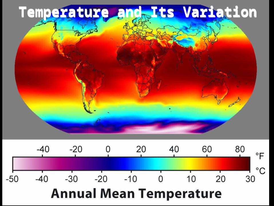
Temperature and Its VariationTemperature and Its Variation
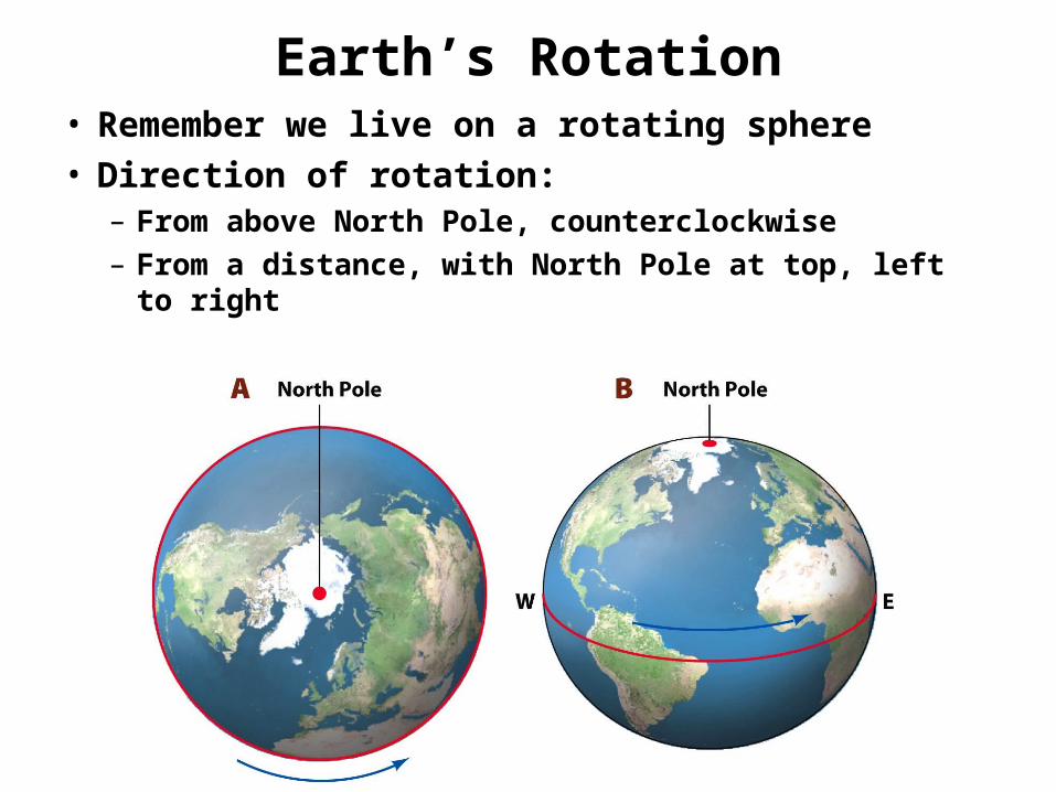
Earth’s RotationEarth’s Rotation• Remember we live on a rotating sphere• Direction of rotation:
– From above North Pole, counterclockwise– From a distance, with North Pole at top, left to right
• Remember we live on a rotating sphere• Direction of rotation:
– From above North Pole, counterclockwise– From a distance, with North Pole at top, left to right

Effects of Earth’s RotationEffects of Earth’s Rotation
• 3 main effects:– Axis and equator basis of geographic grid
– A day is a convenient measure of time passing
– Diurnal, or daily, rhythm in daylight, air temp, etc.
• Surface processes all respond to diurnal rhythm
• Coriolis force due to Earth’s rotation– How fast are you moving at the Equator?
– At the Poles?

Earth’s Revolution around SunEarth’s Revolution around Sun• 365.242 days / orbit → Feb 29th every 4th year• Counterclockwise motion from above
• 365.242 days / orbit → Feb 29th every 4th year• Counterclockwise motion from above
• Elliptical orbit: There is a 6% difference in insolation between Perihelion and Aphelion.
• Perihelion– Closest to Sun
– Jan. 3rd
• Aphelion– Farthest from Sun
– July 4th
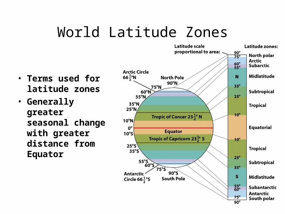
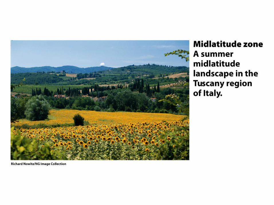
World Latitude ZonesWorld Latitude Zones
• Terms used for latitude zones
• Generally greater seasonal change with greater distance from Equator
• Terms used for latitude zones
• Generally greater seasonal change with greater distance from Equator


Solar Heating of Land & WaterSolar Heating of Land & Water
• Surface layer of large body of water heats & cools more slowly than land
• This difference shows up in temp patterns– e.g. diurnal temp pattern, maritime vs. continental
• Surface layer of large body of water heats & cools more slowly than land
• This difference shows up in temp patterns– e.g. diurnal temp pattern, maritime vs. continental
San Francisco(Maritime)
Yuma(Continental)


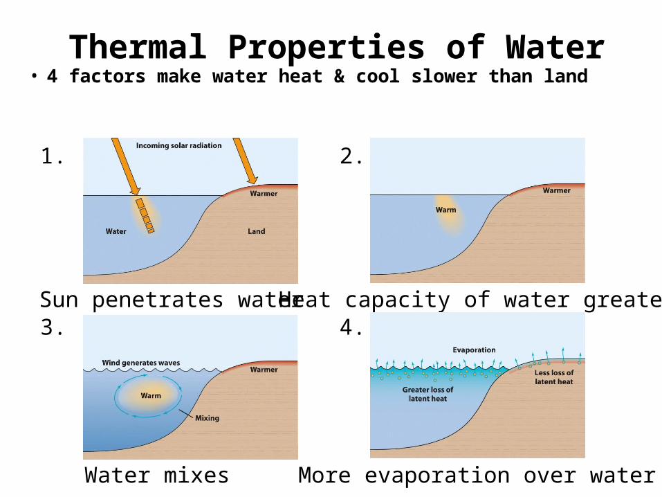
Thermal Properties of WaterThermal Properties of Water• 4 factors make water heat & cool slower than land• 4 factors make water heat & cool slower than land
1.
Sun penetrates water
2.
Heat capacity of water greater3.
Water mixes
4.
More evaporation over water

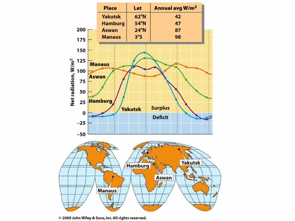
5 Factors Influencing Local Temps5 Factors Influencing Local Temps
• Latitude – less insolation at higher latitudes
• Surface type – urban land absorbs more heat
• Coastal vs. Interior – less temp range at coast
• Elevation – temps decrease with altitude– Greater annual temp range at high latitudes
• Atmospheric & oceanic circulation- temp can vary greatly based on where air & sea water are coming from
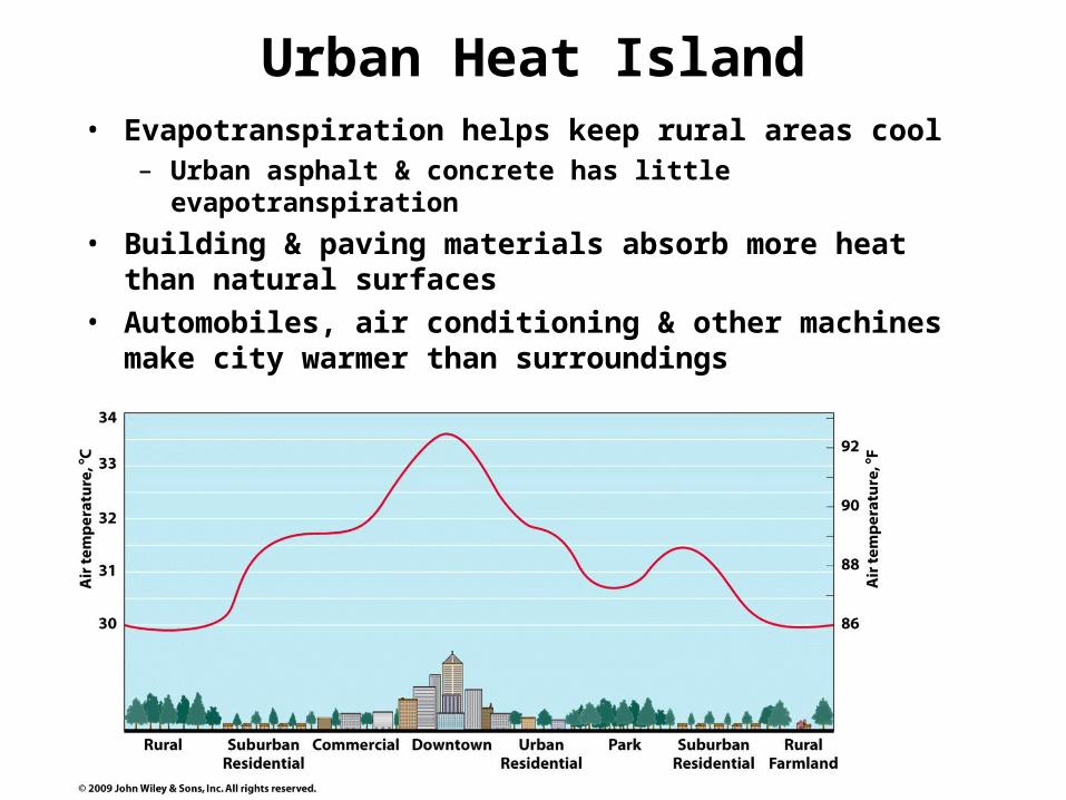
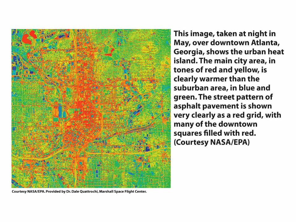
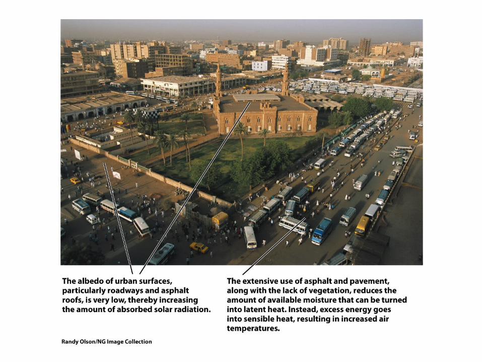
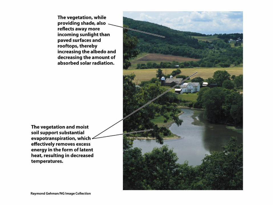
Urban Heat IslandUrban Heat Island• Evapotranspiration helps keep rural areas cool
– Urban asphalt & concrete has little evapotranspiration
• Building & paving materials absorb more heat than natural surfaces
• Automobiles, air conditioning & other machines make city warmer than surroundings
• Evapotranspiration helps keep rural areas cool– Urban asphalt & concrete has little evapotranspiration
• Building & paving materials absorb more heat than natural surfaces
• Automobiles, air conditioning & other machines make city warmer than surroundings

Daily Cycle of Radiation & Air TempDaily Cycle of Radiation & Air Temp
• Shortwave radiation from Sun greater than longwave radiation during daylight hours.
• Energy surplus in daylight
• Deficit in darkness• Temp usually
highest in mid- afternoon, lowest just after sunrise

Maritime vs. ContinentalMaritime vs. Continental
• Daily range of temp less at maritime location• North Head, WA much less range than El
Paso, TX throughout the year
• Daily range of temp less at maritime location• North Head, WA much less range than El
Paso, TX throughout the year

Annual Cycle of Air TemperatureAnnual Cycle of Air Temperature
• Annual temperature range = max temp
month – min temp month
• 2 most important factors:
– Annual insolation (latitude)
– Maritime or continental effect
• Like daily temp cycle, maritime climates
have less annual temp range than
continental
• Annual temperature range = max temp
month – min temp month
• 2 most important factors:
– Annual insolation (latitude)
– Maritime or continental effect
• Like daily temp cycle, maritime climates
have less annual temp range than
continental

Annual Cycle of Air TemperatureAnnual Cycle of Air Temperature
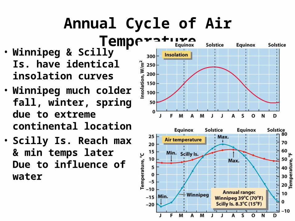
• Winnipeg & Scilly Is. have identical insolation curves
• Winnipeg much colder fall, winter, spring due to extreme continental location
• Scilly Is. Reach max & min temps later Due to influence of water
• Winnipeg & Scilly Is. have identical insolation curves
• Winnipeg much colder fall, winter, spring due to extreme continental location
• Scilly Is. Reach max & min temps later Due to influence of water
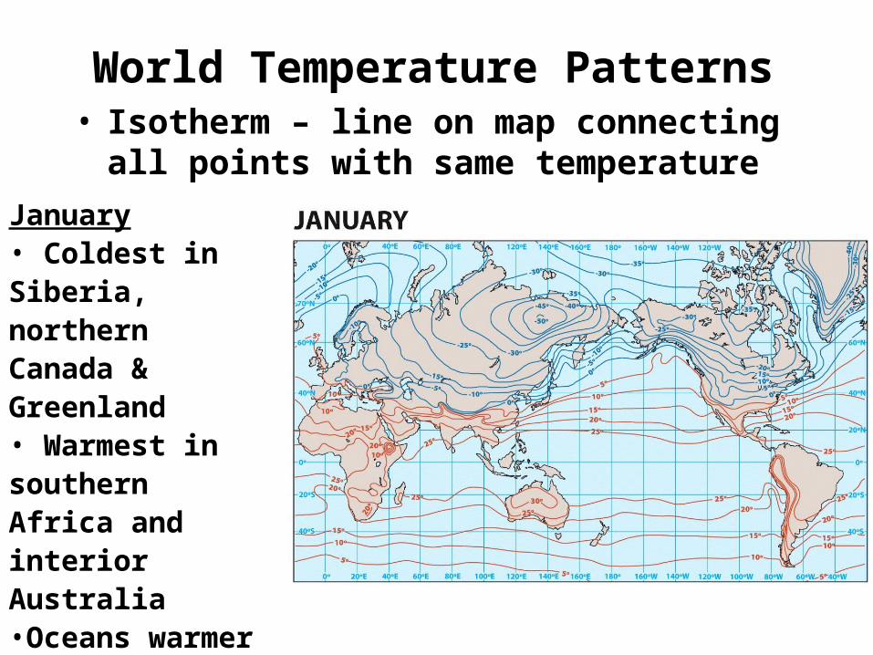
World Temperature PatternsWorld Temperature Patterns• Isotherm – line on map connecting all
points with same temperature• Isotherm – line on map connecting all
points with same temperature
January• Coldest in Siberia, northern Canada & Greenland• Warmest in southern Africa and interior Australia•Oceans warmer than land in northern hemisphere

World Temperature PatternsWorld Temperature Patterns• Maritime influence warms in winter, cools in
summer• Maritime influence warms in winter, cools in
summerJuly• Northern hemisphere continents have warmed dramatically since January• Aside from Antarctica, southern hemisphere not very cold in winter• Maritime influence
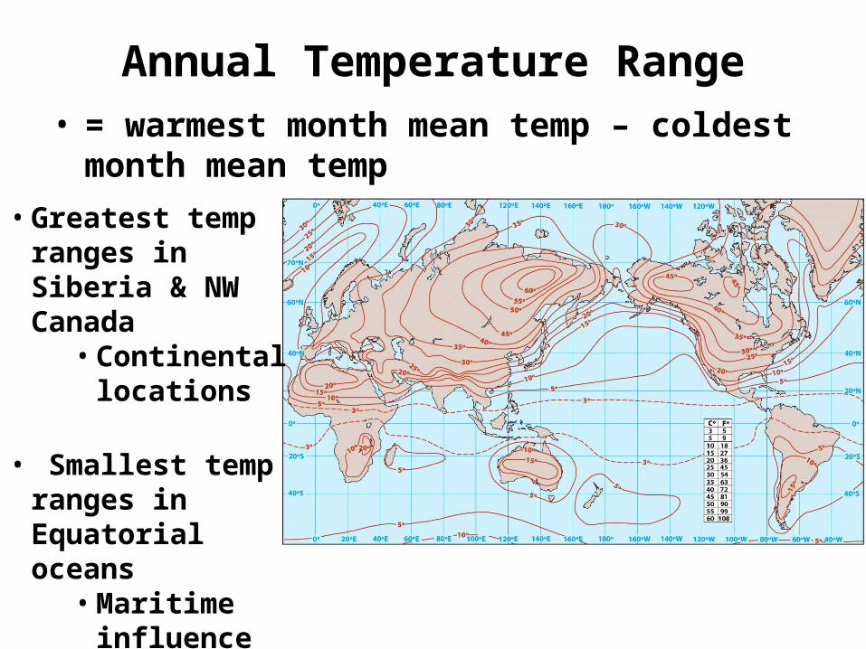
Annual Temperature RangeAnnual Temperature Range• = warmest month mean temp – coldest
month mean temp• = warmest month mean temp – coldest
month mean temp
• Greatest temp ranges in Siberia & NW Canada
• Continental locations
• Smallest temp ranges in Equatorial oceans
• Maritime influence

Wind-Chill IndexWind-Chill Index
• “Feel” of temperature – based on:– Actual temperature– Windspeed – higher means colder
• “Feel” of temperature – based on:– Actual temperature– Windspeed – higher means colder
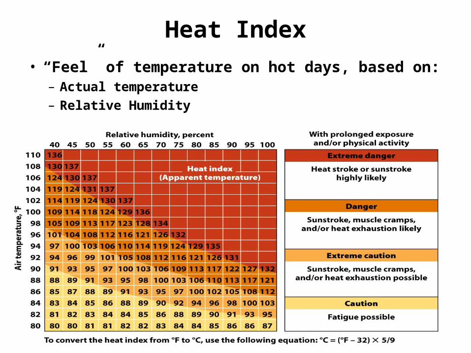
Heat IndexHeat Index
• “Feel” of temperature on hot days, based on:– Actual temperature– Relative Humidity
• “Feel” of temperature on hot days, based on:– Actual temperature– Relative Humidity
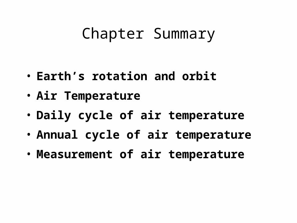
Chapter SummaryChapter Summary
• Earth’s rotation and orbit
• Air Temperature
• Daily cycle of air temperature
• Annual cycle of air temperature
• Measurement of air temperature
• Earth’s rotation and orbit
• Air Temperature
• Daily cycle of air temperature
• Annual cycle of air temperature
• Measurement of air temperature
![Medial Position and Counterclockwise Rotation of the ...downloads.hindawi.com/journals/tswj/2008/843427.pdfcounterclockwise [CCW]) of the PWs (see Fig. 1). Handedness was assessed](https://img.pdfslide.net/doc/110x75/5ace035f7f8b9aa1518e26d8/medial-position-and-counterclockwise-rotation-of-the-ccw-of-the-pws-see.jpg)


![Introduction to Mechanical Aptitudelaface.us/MA/MechanicalGuide[1].pdf · Introduction to Mechanical Aptitude as the ... assemble a cardboard ... counterclockwise indicates rotation](https://img.pdfslide.net/doc/110x75/5aa1c2eb7f8b9a1f6d8c5c86/introduction-to-mechanical-1pdfintroduction-to-mechanical-aptitude-as-the-.jpg)