Embed Size (px)
Citation preview
CALIFORNIA REGIONAL WATER QUALITY CONTROL BOARD SAN FRANCISCO BAY REGION
TENTATIVE ORDER UPDATED WASTE DISCHARGE REQUIREMENTS AND RESCISSION OF ORDER NO. 96-041: REPUBLIC SERVICES, INC. and REPUBLIC SERVICES VASCO ROAD, LLC. VASCO ROAD LANDFILL CLASS III SOLID WASTE DISPOSAL FACILITY LIVERMORE, ALAMEDA COUNTY The California Regional Water Quality Control Board, San Francisco Bay Region, (hereinafter called the Water Board), finds that: 1. Vasco Road Landfill is owned and operated by Republic Services Vasco Road, LLC, and
Republic Services, Inc. (hereinafter called the Discharger or Republic Services). Hereinafter, the Vasco Road Landfill is called VRL or the landfill.
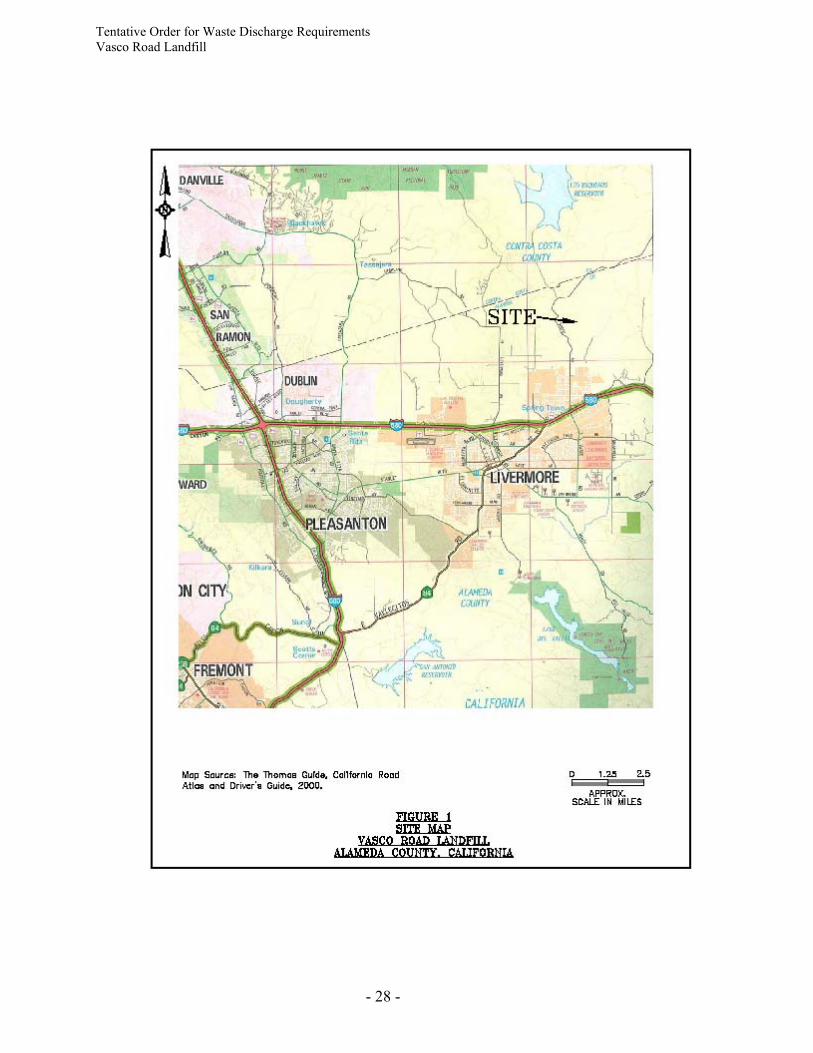
2. VRL is a Class III municipal refuse disposal site located on Vasco Road about three miles
north of Interstate 580 in an unincorporated portion of eastern Alameda County north of the City of Livermore (Figure 1).
3. VRL was permitted in 1962 and began accepting waste in 1963. VRL was originally owned
by Ralph Properties Inc. and operated by DePaoli Equipment Company. Browning Ferris Industries of California, Inc. (BFI) purchased the property in 1989. Allied Waste Industries, Inc. acquired BFI assets, including the VRL, in 1999. Republic Services purchased the landfill in January 2000.
4. VRL accepts nonhazardous solid waste and inert waste. No hazardous wastes, liquid
wastes, or infectious wastes are accepted at the site. However, disposal units constructed after 1993 are authorized for disposal of Class II designated wastes, as they were designed and constructed in compliance with Part 258 of Title 40 of the Code of Federal Regulations (CFR) (referred to as “Subtitle D”) and State Water Resources Control Board (State Board) Resolution No. 93-62.
PURPOSE OF ORDER 5. The purpose of this Order is to:
(a) update waste discharge requirements (WDRs) to reflect current landfill operations, design, and construction of waste disposal units;
(b) reflect changes to the final closure schedule; (c) update designated waste acceptance criteria for disposal units constructed in
compliance with Subtitle D;

Tentative Order for Waste Discharge Requirements Vasco Road Landfill
- 2 -
(d) specify monitoring, control, and collection requirements for groundwater, leachate, landfill gas and landfill gas condensate, and storm water consistent with Title 27 of the California Code of Regulations (CCR); and
(e) rescind the current WDRs (Water Board Order No. 96-041). 6. This Order does not authorize the filling of wetlands or waters of the State. Such activities
require certification of water quality impacts by the Water Board or Executive Officer pursuant to Section 401 of the Clean Water Act. Such activities may also require amendment or update of WDRs contained in this Order for the proposed fill area.
SITE DESCRIPTION AND LOCATION 7. VRL is a canyon-fill disposal facility located in rolling hills of the northern Diablo Range
north of the Livermore Valley. Land surrounding the landfill is primarily privately owned ranch land and open space maintained by the East Bay Regional Parks District. Disposal units are constructed in phases as interim fill capacity is reached in previously constructed units until the final build-out of the entire landfill configuration is reached.
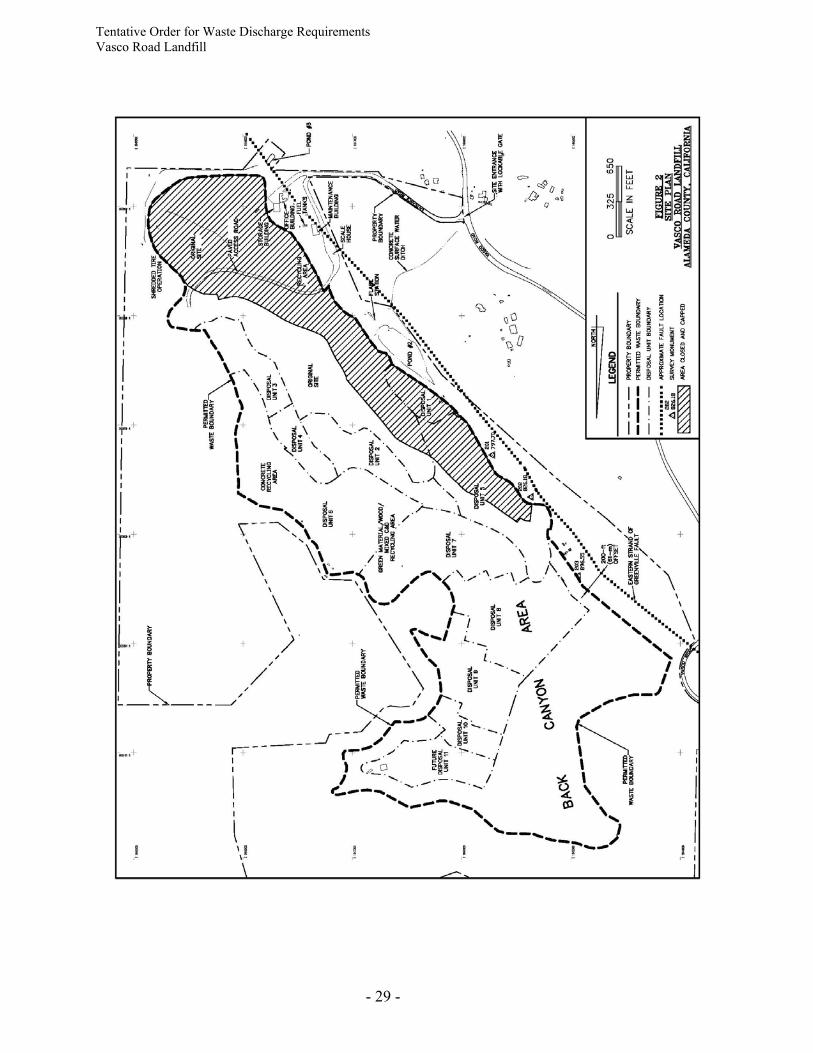
8. The landfill disposal area consists of approximately 323 acres, of which approximately 263
acres known as Area X are permitted for waste disposal (Figure 2). However, only approximately 246 acres within Area X can actually receive waste because the Discharger is required to maintain a 200-foot buffer zone between the eastern strand of the Greenville Fault and any future waste disposal areas (see Finding 25). The developed disposal area currently occupies approximately 183 acres. About 55.5 acres of the facility are closed under final cover.
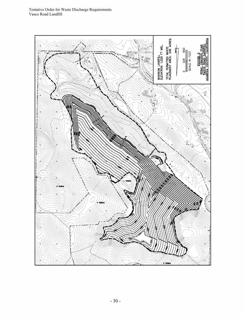
9. The final landfill elevation will range from 1,000 to 1,025 feet above mean sea level (msl),
depending upon location within the permitted waste boundary (Figure 3). Based on the site development plan, the landfill has a permitted site capacity of about 32,970,000 cubic yards. As of December 2007, approximately 22,500,000 cubic yards of waste have been deposited at the landfill. Under current fill plans, the landfill is expected to reach final capacity in 14 years (around 2022).
REGULATORY HISTORY
10. Vasco Road Landfill currently operates under the following permits:
(a) Solid Waste Facility Permit (SWFP) No. 01-AA-0010, issued by the Alameda County Environmental Health Department (Enforcement Agency) on June 19, 2007.
(b) Waste Discharge Requirements Order No. 96-041, adopted by the Water Board on
March 20, 1996. (c) Conditional Use Permit C-4158, adopted by Alameda County Board of Supervisors
on May 4, 2006.
(d) Bay Area Air Quality Management District (BAAQMD) Permit to Operate (PTO) Plant No. 5095, dated April 18, 2007.
Tentative Order for Waste Discharge Requirements Vasco Road Landfill
- 3 -
11. The Discharger submitted a Report of Waste Discharge (ROWD) in 1986 and a Report of
Disposal Site Information (RDSI) in October 1999. The ROWD and RDSI were updated in December 2006 with submission of a Joint Technical Document (JTD). The JTD was approved by the Alameda County Enforcement Agency in 2007. The JTD proposed construction and operation details for the landfill in accordance with state and federal regulations.
12. The JTD, submitted December 2006, includes preliminary closure and post-closure
maintenance plans (PCPMPs). The PCPMPs describe the methods and controls to be used to assure protection of the quality of surface water and groundwater of the area during final operations and following final closure of the landfill. The PCPMPs include an estimate of closure and post-closure maintenance costs and propose a financial mechanism to finance costs associated with closure and post-closure activities.
13. Since WDRs were last updated in 1996, the Discharger has submitted the following
documents (not including disposal cell design reports, construction quality assurance (CQA) reports, and routine groundwater monitoring reports):
(a) GeoSyntec Consultants, Inc., “Partial Final Closure Plan, Disposal Units 1 and 5, Vasco
Road Sanitary Landfill, Livermore, California,” January 30, 1998. (b) GeoSyntec Consultants, Inc., "Updated Report of Disposal Site Information, Vasco
Road Sanitary Landfill, Livermore, California," October 25, 1999. (c) GeoSyntec Consultants, Inc., “Geologic and Geotechnica Assessment of the Proposed
Preliminary Cut Slopes for DU-8, Vasco Road Sanitary Landfill, Livermore, California,” May 2001.
(d) GeoSyntec Consultants, Inc., “Evaluation of Site –Specific Hydrogeologic and
Hydrochemical Conditions, MW-17, MW-39, and MW-42, Vasco Road Landfill, Livermore, California,” February 28, 2005.
(e) GeoSyntec Consultants, Inc., “Geologic Assessment, Phase 2 of DU-9 and DU-10
(Preliminary), Vasco Road Landfill, Livermore, California,” May 1, 2006. (f) GeoSyntec Consultants, Inc., "2006 Final Grading Plan Modification, Vasco Road
Landfill, Livermore, California," July 7, 2006. (g) Geosyntec Consultants, Inc., "Conceptual Master Plan, Vasco Road Landfill,
Alameda County, California," December 15, 2006 (revised January 31, 2007). (h) GeoSyntec Consultants, Inc., "Joint Technical Document, Vasco Road Landfill,
Alameda County, California," December 28, 2006. (i) GeoSyntec Consultants, Inc., “Geologic Assessment of Area of Disposal Units 10 and
11 (DU-10/11), Vasco Road Landfill, Livermore, California,” June 14, 2007.
Tentative Order for Waste Discharge Requirements Vasco Road Landfill
- 4 -
WASTES AND THEIR CLASSIFICATION 14. VRL was designed to receive nonhazardous solid waste, as classified in Section 20220(a) of
Title 27, from residential, commercial, and industrial sources. Nonhazardous solid waste includes, but is not limited to, putresible and nonputresible solid, semi-solid, and liquid wastes including garbage, trash, refuse, paper, rubbish, ashes, industrial wastes, demolition and construction wastes, and soil. Wastes that can be accepted at VRL include residential garbage and rubbish, commercial and nonhazardous industrial refuse, demolition and construction waste, hydrocarbon profiled soils, sewage sludge or biosolids, industrial sludges, brush and stumps, tires, and street refuse.
15. No hazardous wastes, liquid wastes, or infectious wastes can be accepted at the site.
16. As stated in Finding 2, VRL is classified as a Class III landfill. However, disposal cells constructed since 1993 (i.e., Disposal Units (DUs) 6, 7, 8, 9, and 10) have been designed and constructed to comply with the requirements of Subtitle D and meet the State siting and design requirements for a Class II waste management unit. The construction standards of DU-6, DU-7, DU-8, DU-9, and DU-10 provide a lower risk of water quality degradation than is generally afforded by Class III landfills. All future disposal units must be constructed to comply with Federal (Subtitle D) and State (Title 27) requirements for Class II waste management units.
17. The Discharger is permitted to dispose of designated wastes, including treated wood waste and sewage sludge, in all disposal units that have been designed and constructed in compliance with Subtitle D and Title 27 criteria, including DU-6, DU-7, DU-8, DU-9, DU-10, and all future cells that meet Subtitle D and Title 27 requirements.
18. Wastes containing asbestos may be disposed at VRL in accordance with Section 25143.7 of the Health and Safety Code and Sections 66268.29 and 66268.100 (a)(13) and 66268.114 of Title 22 of the CCR.
19. Certain waste materials are being reused at VRL for various beneficial applications within the permitted waste boundary, including alternative daily cover (ADC) and construction of access and bench roads, tipping area decks, intermediate pads, backfilling trenching projects, backfilling leachate seeps, repairing eroded areas, filling settlement depressed areas, storm-water berms, etc.
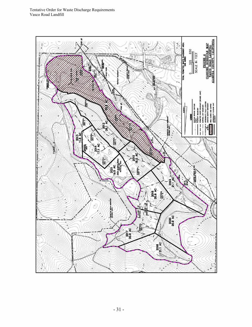
PHYSICAL SETTING
Surface Hydrology 20. The natural site topography of the area varies from moderate to steep, with elevations
ranging from about 750 feet above MSL along the south side of the site to nearly 1,060 feet above MSL along the north boundary. In 2007, the top surface elevation of the landfill was 1010 feet above MSL.
21. The landfill is constructed in a northwest-to-southeast trending canyon and is surrounded by fairly steep, rounded hills. The canyon is drained by an unnamed, ephemeral stream.
Tentative Order for Waste Discharge Requirements Vasco Road Landfill
- 5 -
Surface water occurs within the site boundary as an improved spring located in the northern part of the site, upgradient of the current waste disposal areas. This water has historically been used for agricultural use.
22. Surface water runoff from the site is routed around the active filling area by ditches, which direct the runoff to two sedimentation ponds (Ponds #2 and #3) (Figure 2). Discharge from the upper sedimentation pond (i.e., Pond #2) drains westward to an intermittent drainage channel located along Vasco Road (also known as Vasco Creek). The drainage channel flows southward into Kellogg Creek, which flows into Altamont Creek and Arroyo Las Positas Creek into the Livermore Valley. Pond #3, located in the landfill toe area, also drains into Vasco Creek. These tributaries to Alameda Creek also recharge the Livermore Valley Groundwater Basin. Pond #1, which was formerly located within the current waste disposal area, was removed in 2000 – 2001.
23. The mean annual precipitation for the site is about 14 inches. The 100-year, 24-hour storm event is estimated to be 3.69 inches and the 1,000-year, 24-hour storm is estimated to be 4.82 inches. The mean annual evaporation is estimated to be 72.5 inches.
Geology 24. The landfill lies within the Northern Diablo Range along the Altamont Anticline. Rock
strata in this area dip to the west, so that the rocks beneath the eastern portion of the site are older than those in the west. The eastern portion of the site is underlain by rocks of the Panoche Formation, whereas rocks in the western portion of the site belong to the Cierbo Formation. The Panoche Formation is of Cretaceous age and consists of two separate units. The first unit consists of clayey, micaceous shale and siltstone with some locally occurring sandstone interbeds. The second unit consists of resistant sandstone beds with interbedded shale and siltstone. The Cierbo Formation is of Upper Miocene age and consists of fine- to coarse-grained sandstone with some shale and siltstone interbeds.
25. The landfill is located in the seismically active Coast Ranges region. The entire region
experiences moderate seismic activity as the result of strike-slip movement along the regional San Andreas Fault System. The closest active fault to the landfill is the Greenville Fault, which is located along the west side of the site. The main trace of the Greenville Fault lies near Vasco Road, approximately 1000 feet to the west of the permitted waste boundary (Figure 2). The eastern strand of the Greenville Fault lies just outside the western boundary of the site. The waste limit boundary is situated to provide a 200-foot setback from the eastern strand of the fault. There are no known active fault traces within the permitted waste disposal area. However, additional geologic field investigations are required as future excavation and development of the landfill occurs.
26. The Greenville Fault has been active in recent times. A 5.2 Richter Magnitude earthquake occurred along the Greenville Fault on January 26, 1980. The epicenter of this earthquake was located approximately one-half mile southwest of the landfill. The earthquake was of shallow focus and caused considerable damage in the Livermore Valley and in the vicinity of the site. The 1980 earthquake produced minor, discontinuous surface rupture outside the landfill area, but caused no observable damage to the landfill.
Tentative Order for Waste Discharge Requirements Vasco Road Landfill
- 6 -
Hydrogeology 27. VRL is located in the Altamont Subbasin of the Livermore Valley Groundwater Basin.
Groundwater in this basin is managed by the Alameda County Flood Control and Water Conservation District – Zone 7. The Livermore Valley Groundwater Basin provides an important source and reservoir of drinking water for residents of the Livermore Valley.
28. The Altamont Subbasin is bounded on three sides by non-water bearing rocks and on the
fourth side by the Carnegie Fault, which separates this subbasin from the Spring Subbasin to the west. Groundwater in the Altamont Subbasin occurs primarily in valley-fill alluvial materials, which are estimated to be up to 200 feet thick. Groundwater in the Altamont Subbasin is generally of relatively poor ambient quality due to elevated levels of sodium chloride (>350 parts per million (ppm)) and boron (>2 ppm) derived from its passage through sediments of marine origin. Nonetheless, at least 10 active domestic or agricultural groundwater wells are located within one mile of the site.
29. Groundwater beneath the site occurs in three different water-bearing units; in alluvium and
within fractured bedrock of the Panoche and Cierbo Formations. Groundwater elevation data indicates that groundwater beneath the landfill primarily flows from north to south towards the Livermore Valley. Groundwater is encountered in the surficial alluvium at depths ranging from 5 to 10 feet below ground surface (bgs). In the Panoche Formation, depth to groundwater ranges from 3 to 34 feet bgs, while in the Cierbo Formation, depth to groundwater ranges from 3 to 47 feet bgs. Groundwater within the Panoche and Cierbo formations occurs under confined to semi-confined conditions.
30. Rocks of the Panoche Formation have very low hydraulic conductivities in the range of 10-8
to 10-7 centimeters per second (cm/sec), based on laboratory tests of intact core samples. Hydraulic conductivities determined through laboratory studies of the Cierbo Formation rocks range from 10-6 to 10-5 cm/sec. However, groundwater flow occurs primarily through interconnected fractures. Field hydraulic conductivity tests have demonstrated in situ groundwater flow rates through both formations of 10-4 to 10-3 cm/sec.
31. Subsurface recharge to, and discharge from, the site is believed to be insignificant because
of the low hydraulic conductivity and low storage potential of the underlying bedrock. Recharge at the site is primarily from precipitation. The California Department of Water Resources reports that there is very little subsurface outflow from the Altamont Subbasin.
32. In many portions of the landfill, groundwater exists at shallow depths (less than 5 feet bgs),
as stated in Finding 29. For this reason, the required minimum of 5 feet of separation between the water table and the base of waste does not exist in these places unless fill is imported to raise the base of the disposal cell. Consequently, a blanket underdrain system is required in all future disposal cells, unless an alternative is approved by the Executive Officer.
LANDFILL DESIGN AND CONSTRUCTION HISTORY 33. Waste disposal in the landfill began in 1963. A lateral expansion of the landfill was
approved in 1986. The landfill expansion is being constructed as disposal units, beginning
Tentative Order for Waste Discharge Requirements Vasco Road Landfill
- 7 -
with DU-1. Filling of DU-1 through DU-4 occurred in the 1980s. DU-5 was constructed in 1992. The first cell constructed in compliance with Subtitle D requirements, DU-6, was constructed in four phases between 1994 and 1996, followed by three phases of DU-7 (1997-1999), DU-8 (2002) and DU-9 (Phase 1 in 2006 and Phase 2 in 2007). DU-10 was constructed in 2007 and began receiving waste in February 2008.
Original Site (OS) 34. The original landfill consisted of a single disposal cell that ultimately occupied about 64.4
acres. Wastes were placed on an unlined cell floor starting in 1963. This OS unit did not have any means of leachate collection until a leachate barrier (also referred to as groundwater trench and barrier (GWTB)) was constructed at the landfill toe in 1989. The location of the GWTB is shown in Figure 3.
Disposal Unit 1 (DU-1) and Disposal Unit 2 (DU-2)
35. DU-1 covers approximately 3.5 acres and DU-2 covers approximately 9.5 acres. Both disposal cells are unlined. DU-1 was used for the disposal of construction demolition and inert waste. DU-2 received mostly municipal solid waste (MSW).
Disposal Unit 3 (DU-3) 36. DU-3 covers approximately 6.5 acres and is unlined. The original size of DU-3 of 4.5 acres
was enlarged by about 2 acres in 2006 when Alameda County and the Water Board approved landfill horizontal expansion to include waste inadvertently placed outside waste boundary by a previous site owner.
Disposal Unit 4 (DU-4) 37. DU-4 covers approximately 4.3 acres and is partially (about 60%) lined with 12 inches of
compacted clay with a hydraulic conductivity of 1 x 10⁻⁶ cm/s or less. The unit was used for the disposal of Class III wastes.
Disposal Unit 5 (DU-5) 38. DU-5 covers approximately 16.7 acres and is lined with 12 inches of compacted clay with a
hydraulic conductivity of 1 x 10⁻⁶ cm/s or less, and a 60-mil thick high density polyethylene (HDPE) geomembrane over a non-woven geotextile on the west side slope. The unit was constructed in 1992 and was used for the disposal of Class III wastes and Class II designated wastes requiring special handling (i.e., industrial wastes: ashes, treated auto shredder waste, petroleum contaminated soils, sewage and wastewater sludges, industrial sludges, industrial filters, drilling muds, treated wood, and other nonhazardous waste).
Disposal Unit 6 (DU-6) 39. DU-6 is approximately 28.9 acres in size and was constructed in four phases between 1994
and 1996. DU-6 was the first disposal unit at this landfill to be lined with a containment system that fully complies with Subtitle D and Title 27 requirements. The unit has been
Tentative Order for Waste Discharge Requirements Vasco Road Landfill
- 8 -
used for the disposal of Class III waste and Class II designated waste requiring special handling.
40. The DU-6 floor containment system consists of the following layers (from top to bottom): • 18-inch thick operations layer; • non-woven geotextile filter; • 12-inch thick LCRS granular drainage layer; • 80-mil thick HDPE geomembrane liner; • 24-inch thick compacted clay liner (CCL) with a hydraulic conductivity of
1 x 10⁻⁷ cm/sec or less; • non-woven geotextile separator; and • 12-inch thick underdrain/capillary break granular drainage layer.
41. A typical DU-6 side-slope containment system consists of the following layers (from top to bottom): • 18-inch thick operations layer; • geocomposite LCRS; • 80-mil thick HDPE geomembrane liner; • geosynthetic clay liner (GCL) with an underlying 30-mil thick HDPE geomembrane;
and • underdrain/capillary break geocomposite.
42. A containment system was installed over waste in DU-2, DU-3 and DU-4 during
construction of DU-6 to separate existing waste from the DU-6 waste and to provide a continuous leachate barrier. This containment system typically consists of a 3-foot thick compacted foundation layer overlain by a composite liner system (80-mil thick HDPE geomembrane over 24-inch thick CCL), geotextile cushion, and soil operations layer.
Disposal Unit 7 (DU-7) 43. DU-7 was constructed between 1997 and 1999 and includes approximately 17.2 acres. DU-
7 is lined with a containment system meeting Subtitle D and Title 27 requirements. The unit has been used for the disposal of Class III waste and Class II designated waste requiring special handling.
44. The DU-7 floor and side-slope containment systems consist of the same layers as the DU-6 containment systems.
Disposal Unit 8 (DU-8) 45. DU-8 was constructed in 2002 and includes approximately 17.8 acres. DU-8 is lined with a
containment system meeting Subtitle D and Title 27 requirements. The unit has been used for the disposal of Class III waste and Class II designated waste requiring special handling.
46. The DU-8 floor and side-slope containment systems consist of the same layers as the DU-6 containment systems. The DU-8 side-slope containment system also includes a network of 5-ft deep subdrain trenches that discharge into the floor granular underdrain system.
Tentative Order for Waste Discharge Requirements Vasco Road Landfill
- 9 -
Disposal Unit 9 (DU-9) 47. DU-9 was constructed in two phases in 2006 and 2007 and includes approximately 11.9
acres. DU-9 is lined with a containment system meeting Subtitle D and Title 27 requirements. The unit has been used for the disposal of Class III waste and Class II designated waste requiring special handling.
48. The DU-9 floor and side-slope containment systems consist of the same layers as the DU-6 containment systems. Phase 1 of the DU-9 side-slope containment system also includes a network of 5-ft deep subdrain trenches that discharge into the floor granular underdrain system.
Disposal Unit 10 (DU-10) 49. DU-10 includes approximately 4.2 acres and is lined with a containment system meeting
Subtitle D and Title 27 requirements. The unit has been used for the disposal of Class III waste and designated waste requiring special handling.
50. The DU-10 floor and side-slope containment systems consist of the same layers as the DU-6 containment system. The side-slope containment system for DU-10 consists of the same layers as the DU-6 side-slope containment system.
51. An abandoned agricultural well with an 8-inch diameter metal casing was discovered during
excavation of DU-10. The total depth of the well has not been determined. The well must be destroyed in accordance with the Alameda County Flood Control and Water Conservation District – Zone 7 requirements prior to landfill expansion into the DU-11 area.
EXPANSION OF LANDFILL INTO BACK CANYON AREA 52. A lateral expansion of VRL into an area known as the “back canyon” on the north end of the
landfill was approved in 2002. The “back canyon” area includes the areas of DU-8, DU-9, DU-10, and future disposal units DU-11, DU-12, etc. (Figure 2). Resource agencies determined that landfill development within the back canyon area would result in adverse water quality impacts to 2.173 acres of Waters of the United States. The 2.173 acres of impacted waters within the proposed landfill expansion area included 1.176 acres of seasonal wetland, 0.905 acre of open water (a man-made sedimentation pond) and 0.092 acre of “other waters” (approximately 2,000 linear feet of drainage channel). On April 10, 2002, the U.S. Fish and Wildlife Service, in consultation with the U.S. Army Corps of Engineers (COE), issued a Biological Opinion finding that the proposed landfill expansion would cause potential impacts to the federally endangered San Joaquin kit fox and the federally threatened California red-legged frog and its designated critical habitat, and also determined that the site proposed for development provides habitat for the California tiger salamander. Resource management agencies determined that mitigation would be required to offset impacts to jurisdictional wetlands and to the special-status species habitats.
53. The expansion into the “back canyon” area was permitted by the California Department of
Fish and Game (CDFG) via a Streambed Alteration Agreement No. R3-1600-2001-0574 on
Tentative Order for Waste Discharge Requirements Vasco Road Landfill
- 10 -
April 24, 2002. On May 8, 2002, the COE issued a Nationwide Permit pursuant to Section 404 of the Clean Water Act for the creation of the offsite “Bosley mitigation ponds,” but determined that the Corps had no jurisdiction over development within the landfill. On August 6, 2002, the Alameda Country Planning Department, as lead agency for California Environmental Quality Act (CEQA) compliance, certified a Notice of Exemption pursuant to CEQA Guidelines Section 15061(b)(3), “General Rule,” and 15304, “Minor Alterations to Land” for the landfill expansion. On October 8, 2002, the Water Board issued a Water Quality Certification pursuant to Section 401 of the Clean Water Act that covered both the landfill expansion within the “back canyon” area and the offsite mitigation project. Together, these permitting actions by CDFG, Alameda County, COE, and the Water Board authorized the development of the “back canyon” as landfill and provided for the creation of two mitigation ponds on the former Bosley property, located immediately to the east of the landfill.
54. Mitigation consisted of the preservation of approximately 290 acres of open space as a
conservation easement within the Brushy Peak Regional Preserve, owned by the East Bay Regional Parks District. Mitigation measures also included the creation of the two seasonal ponds on the former Bosley property, which is located within the 290-acre conservation easement. The two ponds and associated wetlands totaled 4.86 acres of suitable habitat for the impacted special-status amphibian species (California red-legged frog and California tiger salamander). Construction of the ponds began in 2004 and was completed in 2005.
FILL PLANS Future Development of the Undeveloped Area
55. On January 31, 2007, the Discharger submitted to the Water Board a revised Conceptual Master Plan (CMP) for VRL. The CMP outlined the anticipated development of the landfill’s remaining undeveloped acreage. The currently undeveloped portion of VRL, which measures approximately 63 acres, will be designed and constructed in accordance with the applicable regulations at the time of development. The area will be constructed so that it can receive Class III waste and Class II designated waste requiring special handling.
56. As of May 2008, waste has been placed over approximately 183 acres of the permitted 246 acres of VRL. Future fill plans within the undeveloped 63-acre portion of the site call for construction of DU-11 in 2009, followed by DU-12, DU-13, etc. The build-out of the landfill is anticipated to provide about 14 years of operational capacity, based on a remaining refuse capacity of 10.5 million cubic yards as of December 31, 2007.
57. The containment system design and construction requirements for future disposal units at VRL are detailed in Specification B.18 of this Order.
LANDFILL CLOSURE 58. The landfill shall be properly and sequentially closed as disposal units are filled to reduce
the impacts of the landfill on human health and the environment and to ensure the long-term integrity of the facility following closure.
Tentative Order for Waste Discharge Requirements Vasco Road Landfill
- 11 -
59. Approximately 30 acres of the southern portion of the Original Site (OS) were closed prior to 1986 in basic conformance with either Order No. 78-112 for VRL or the requirements of Subchapter 15 (currently Title 27) of the CCR.
60. In 1999, an additional 25.5 acres of west facing slopes, including DU-1 and portions of DU-
5 and the OS, were closed. This brought the total closed area of VRL to approximately 55.5 acres. Figure 2 shows approximate limits of the closed area of VRL.
61. The Discharger developed a conceptual final grading plan for the VRL presented as Figure 3.
As permitted by Alameda County’s Conditional Use Permit, the maximum landfill elevation will be approximately 1,025 ft msl.
62. The Discharger submitted to the Water Board a Revised Closure Schedule letter, dated April
15, 2008, that proposed a revised closure schedule for the landfill (Figure 4). Water Board staff approved the revised closure schedule in June 2008.
63. Financial Assurance for Post-Closure Monitoring and Maintenance: The Discharger
submitted evidence to the California Integrated Waste Management Board (CIWMB) documenting the existence of a financial assurance mechanism to ensure monitoring and maintenance of the landfill during the post-closure period. The CIWMB approved VRL’s financial assurance mechanism by letter dated May 23, 2007. The estimate of funds available for post-closure monitoring and maintenance was updated on June 12, 2008.
64. Financial Assurance for Corrective Action: The Discharger submitted evidence to the
Water Board documenting the existence of a financial assurance mechanism to ensure corrective actions that may be necessary as a result of current or future unforeseen releases from the landfill. This letter was submitted on July 7, 2003 and approved by the Water Board on March 11, 2004. The estimate of funds available for corrective actions was updated on June 12, 2008.
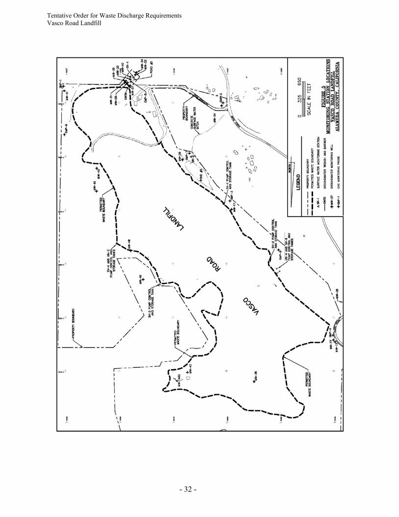
MONITORING, COLLECTION, AND CONTROL PROGRAMS Groundwater 65. The current groundwater monitoring network consists of 13 monitoring stations, including
11 monitoring wells, a spring, and a water storage tank. Monitoring station locations are shown in Figure 5. The monitoring stations include: • shallow (alluvial), upgradient groundwater monitoring well MW-13; • shallow (alluvial), downgradient groundwater monitoring wells MW-27, MW-32 and
MW-54; • deep (bedrock), background groundwater monitoring wells MW-36, MW-37, MW-42
and MW-48; • deep (bedrock), downgradient groundwater monitoring wells MW-17, MW-29, and
MW-39; • background spring MW-1492; and • above-ground water storage tank (WST). WST represents a mixture of landfill toe area
alluvial groundwater and leachate that is collected in the interceptor groundwater collection trench and barrier (GCTB) and automatically pumped into the tank.
Tentative Order for Waste Discharge Requirements Vasco Road Landfill
- 12 -
66. As VRL expands within the approved waste boundaries, i.e., into DU-11, DU-12, etc., the
monitoring stations located at spring MW-1492 and deep monitoring wells MW-36 and MW-37 will have to be abandoned and/or destroyed. New monitoring stations shall be installed to replace monitoring wells destroyed during expansion.
67. Site groundwater is monitored semi-annually for pH, electrical conductivity (EC), total dissolved solids (TDS), chloride, nitrate (as nitrogen), sulfate, turbidity, and volatile organic compounds (VOCs) (EPA Method 8260).
Leachate 68. VRL has five leachate collection and recovery system (LCRS) sumps. These include SV-1
and SV-2 in DU-5, SV-3 and SV-4 in DU-6, and SV-6 which serves DU-7, DU-8, DU-9, and DU-10.
69. Leachate control measures for the unlined portion of the landfill consist of the GCTB and the associated extraction system constructed at the landfill toe. The GCTB was installed in 1990 and consists of a 3-foot wide, 256-foot long trench excavated through alluvium and keyed into Panoche Formation bedrock to a maximum depth of approximately 37 feet bgs. A vertical HDPE water collection riser and submersible pump was installed in the deepest portion of the trench. The trench was backfilled with permeable rock to facilitate drainage into the trench. A 60-mil thick HDPE geomembrane was installed along the downgradient side of the trench to impede the flow of water across the trench. Water collected in the GCTB is pumped to an above-ground 16,000 gal water storage tank located in the maintenance yard via double-walled pipe.
70. Leachate control measures for the Subtitle D-lined portion of the landfill include a blanket-type LCRS located on the base of the expansion area. This horizontal barrier is designed to intercept and prevent downward migration of leachate into the underlying geologic materials. Leachate generated within the lined areas is collected in the five LCRS sumps (i.e., SV-1, SV-2, SV-3, SV-4, and SV-6), and removed from each sump on a daily basis by automatically controlled pumps.
71. Leachate collected from the sumps is contained onsite in five 10,000 gallon tanks. Leachate is transferred from these tanks into the site water truck and reinjected into lined disposal units that comply with Subtitle D construction requirements.
72. Leachate is monitored and sampled quarterly at the five sumps. The amount of leachate extracted from the sumps has been recorded since 1996. Leachate samples typically show low concentrations of certain VOCs such as benzene, chlorobenzene, MTBE, naphthalene, and vinyl chloride.
Storm Water and Surface Water 73. Parts 122, 123, and 124 of Chapter 40 of the CFR require specific categories of industrial
activities, including landfills, to obtain a National Pollutant Discharge Elimination System (NPDES) permit for storm water discharges. The State Water Resources Control Board
Tentative Order for Waste Discharge Requirements Vasco Road Landfill
- 13 -
(State Board) has issued a General Permit for Storm Water Discharges Associated with Industrial Activities (NPDES Permit No. CAS00000l). The landfill is subject to the requirements of the State Board's General Permit and as such is required to (1) submit a Notice of Intent (NOI) for coverage under the General Permit, (2) prepare and implement a monitoring program, and (3) submit an annual report.
74. To comply with the Storm Water General Permit, storm water is sampled twice yearly at two locations (SR-1 and SR-2). Station SR-1 is located at the outlet of Pond #3 (landfill toe area) and station SR-2 is located at the bottom of the Pond #2 spillway (Figure 5).
Landfill Gas 75. The Gas Collection and Control System (GCCS) is regulated by the Bay Area Air
Management District (BAAQMD). The GCCS consists of collection wells located in the landfill that are connected to a header pipeline network to transmit landfill gas under vacuum pressure to the landfill gas flare system. The landfill gas flare burns the gas to reduce potential pollutant emissions.
76. The landfill gas monitoring system at VRL currently consists of 8 perimeter gas migration monitoring probes and 5 continuous gas detection monitors located in on-site buildings. The perimeter probes are monitored quarterly using a hand-held gas monitor. A record of the landfill gas monitoring logs is maintained on site. The landfill gas monitoring network will be expanded as landfill expansion occurs to meet the requirements of Title 27.
WATER QUALITY IMPACTS
77. Groundwater monitoring in the 1980s showed the presence of low levels of several VOCs in the alluvial water-bearing unit in the landfill toe area. A groundwater extraction trench was installed in 1989 at the mouth of the canyon to intercept impacted groundwater. The GWTB has been successful as a means of capturing impacted groundwater, and for the past several years, groundwater downgradient from the trench has met drinking water standards.
78. In the late 1990s, a number of VOCs began being consistently detected at low levels in groundwater samples downgradient from the landfill toe area and the GWTB. In 2001 Republic Services initiated an Evaluation Monitoring Program (EMP) to evaluate this potential release from the landfill. The EMP for the landfill toe area is ongoing. The EMP originally included quarterly sampling and testing for VOCs and semiannual testing for certain metals at the six EMP stations (i.e., MW-27, MW-31, MW-32, MW-33, MW-35 and WST) (Figure 5). In 2005, with approval from Water Board staff, EMP sampling frequency has been reduced from quarterly to semiannual sampling. Current monitoring results (from sampling conducted in February 2008) do not indicate the presence of VOCs in the shallow alluvial groundwater monitoring wells.
79. In 1996, groundwater collected from the DU-6 underdrain was impacted with VOCs. A hydrochemical investigation conducted by the Discharger concluded that landfill gas from unlined disposal cells had impacted the quality of the underdrain water. Current concentrations of detected VOCs in the underdrain samples are below their respective primary maximum contaminant levels (MCL) for drinking water established by the
Tentative Order for Waste Discharge Requirements Vasco Road Landfill
- 14 -
California Department of Health Services (DHS). Underdrain water is used for dust control over the lined landfill areas if sampling shows that it meets drinking water standards for VOCs.
80. Over the past several years, concentrations of chloride ion and total dissolved solids (TDS) were observed to be increasing over time in groundwater samples from two deep downgradient groundwater monitoring wells, MW-17 and MW-39. To evaluate whether these increasing trends are an indication of a release from the landfill or caused by other factors, the Discharger initiated a hydrochemical evaluation that consisted of monitoring groundwater on a quarterly schedule for a period of two years at seven specific monitoring locations (MW-17, MW-39, SV-1, SV-2, SV-3, SV-4 and SV-5). Groundwater samples were analyzed for inorganic parameters including TDS, alkalinity, chloride, pH, sulfate, dissolved calcium, dissolved magnesium, dissolved potassium, and dissolved sodium. This evaluation was performed in 2002 and 2003. In 2004, Republic Services conducted a supplemental hydrogeologic evaluation in the vicinity of monitoring wells MW-17, MW-39 and MW-42. These evaluations showed that:
• Well MW-42 is separated from the landfill by a groundwater divide and intercepts groundwater that does not flow beneath the landfill. Therefore, MW-42 represents “background” water quality;
• The increasing TDS and chloride concentrations in wells MW-17, MW-39 and MW-42 are not consistent with the concentrations of these chemicals in VRL leachate, but rather reflect flow of high-TDS and high-chloride groundwaters that exist naturally in the vicinity of VRL. The trends may reflect changes in groundwater flow patterns caused by excavations associated with landfill development.
81. In 2006, Water Board staff approved a request from the Discharger to terminate the EMP for monitoring wells MW-17, MW-39 and MW-42, and these wells were subsequently returned to the Detection Monitoring Program.
BASIN PLAN AND RESOLUTIONS 82. The Water Quality Control Plan for the San Francisco Bay Basin (Basin Plan) is the Water
Board's master water quality control planning document. It designates beneficial uses and water quality objectives for waters of the State, including surface waters and groundwater. It also includes programs of implementation to achieve water quality objectives. The Basin Plan was duly adopted by the Board and approved by the State Water Resources Control Board, the Office of Administrative Law, and the U.S. EPA where required.
83. The Basin Plan provides that all groundwater is considered suitable, or potentially suitable,
for municipal or domestic water supply (MUN) and that, in making any exceptions, the Water Board will consider the criteria referenced in Water Board Resolution No. 89-39, “Sources of Drinking Water,” where:
(a) the total dissolved solids exceed 3,000 mg/liter or electrical conductivity exceeds 5,000
μS/cm, or
Tentative Order for Waste Discharge Requirements Vasco Road Landfill
- 15 -
(b) there is contamination, either by natural processes or human activity (unrelated to the specific pollution incident), that cannot reasonably be treated for domestic use using best management practices or best economically achievable treatment practices, or
(c) the water source does not provide sufficient water to supply a single well capable of
producing an average, sustained yield of 200 gallons per day. BENEFICIAL USES OF SURFACE WATER AND GROUNDWATER Groundwater 84. The site resides within the Altamont Subbasin of the Livermore Valley Groundwater Basin,
as defined in the Basin Plan. The existing and potential beneficial uses identified for groundwater in this basin, according to the Basin Plan, include:
(a) Municipal and Domestic Supply (MUN) (b) Industrial Process Supply (PROC) (c) Industrial Service Supply (IND) (d) Agricultural Supply (AGR).
85. Based on the hydrogeologic characterization and water quality data for the site, groundwater
underlying the site qualifies as a potential source of drinking water in accordance with Water Board Resolution No. 89-39. Therefore, all of the above current and potential beneficial uses apply to groundwater beneath the site. However, as groundwater at the site occurs within thin, low-yield alluvial sediments and low-permeability, fractured bedrock, the landfill site is considered an unlikely location for future water supply wells.
Surface Water 86. Existing or potential beneficial uses identified for surface water in the Livermore Valley
watershed, according to the Basin Plan, include: (a) Municipal and Domestic Supply (MUN) (b) Industrial Process Supply (PROC) (c) Industrial Service Supply (IND) (d) Agricultural Supply (AGR) (e) Water Contact Recreation (REC1) (f) Non-Water Contact Recreation (REC2) (g) Wildlife Habitat (WILD) (h) Preservation of Rare and Endangered Species (RARE).
CALIFORNIA ENVIRONMENTAL QUALITY ACT 87. Development of the VRL has occurred under a final Environmental Impact Report (EIR)
certified by the County of Alameda in 2006 in accordance with the CEQA Public Resources Code Section 21000 et seq. In the EIR, it was determined that the landfill and proposed landfill activities approved by the County could cause significant effects on water quality
Tentative Order for Waste Discharge Requirements Vasco Road Landfill
- 16 -
and may degrade the water quality, unless appropriate mitigation measures are taken. The EIR stated that potential impacts to water quality could occur as a result of:
(a) Earthquake damage or failure of the landfill containment system; (b) Slope instability or failure as a result of water saturation of embankments; (c) Potential degradation of surface water quality as a result of increased sediment load
and/or erosion; (d) Potential groundwater contamination due to contact with landfill leachate; (e) Potential downstream impacts to aquatic biota from accidental discharge of
contaminated water; and (f) Alteration of existing surface and groundwater flow.
88. These potential impacts are mitigated or avoided by a series of design measures to control
erosion and assure containment of waste and leachate through the use of liners, LCRS, groundwater control measures, and limits on the physical dimensions of the fill. The mitigation measures are described in the JTD, the Conditional Use Permit, and by the provisions of this Order for the landfill. It is intended that the findings, prohibitions, specifications, and provisions of this Order be consistent with the Final EIR.
89. Adoption of this Order relates to construction and operation of waste management units
within a permitted waste disposal area and is thus categorically exempt from the provision of CEQA pursuant to Section 15301, Title 14 of the CCR.
NOTIFICATION AND PUBLIC MEETING 90. The Water Board has notified the Discharger and interested agencies and persons of its
intent to update these WDRs and has provided these parties with an opportunity to submit their written views and recommendations.
91. The Water Board in a public meeting heard and considered all comments pertaining to the
proposed WDRs for the site. IT IS HEREBY ORDERED pursuant to the authority in Division 7, Section 13263 of the California Water Code (CWC), Title 27, Division 2, Subdivision 1 of the California Code of Regulations (Title 27), and State Board Resolution No. 93-62 that the Discharger, its agents, successors, and assigns shall meet the applicable provisions contained in Title 27, Division 7 CWC, and State Board Resolution No. 93-62, and shall comply with the following: A. PROHIBITIONS 1. Waste shall not be exposed at the surface of any waste unit, except at the working landfill
face during disposal operations. 2. Wastes shall not be disposed of in any position where they can be carried from the disposal
site and discharged into waters of the State or of the United States.
Tentative Order for Waste Discharge Requirements Vasco Road Landfill
- 17 -
3. The discharge or storage of hazardous waste, as defined in Section 2521 of Title 23 and in CCR Title 22, is prohibited.
4. The discharge of wastes which have the potential to reduce or impair the integrity of the
containment structures or which, if commingled with other wastes in the unit could produce chemical reactions that create heat, pressure, fire, explosion, toxic by-products, or reaction products, is prohibited.
5. The relocation of wastes is prohibited without prior Water Board staff concurrence. 6. The relocation of wastes to or from any waste management unit (WMU) shall not create a
condition of pollution or nuisance as defined in Section 13050(l) and (m) of the California Water Code. Any relocated waste shall not be placed in or allowed to contact ponded water from any source whatsoever. Wastes shall not be relocated to any location where they can be discharged into waters of the State or of the United States.
7. Excavation within, or reconfiguration of, any existing WMU is prohibited without prior
concurrence of Water Board staff. Minor excavation or reconfiguration activities such as for installation of signs or landscaping, or for routine maintenance and repair, do not require prior staff concurrence.
8. Wastes shall not be placed in any area of a new WMU without Executive Officer approval
based on receipt of an adequate CQA report(s) certified by a California-Registered Civil Engineer or California-Certified Engineering Geologist.
9. Groundwater quality shall not be degraded as a result of the waste disposal operation. 10. Filling of wetlands or waters of the State at the landfill without certification of water quality
impacts associated with the proposed filling by the Water Board or Executive Officer pursuant to Section 401 of the Clean Water Act is prohibited.
11. Surface drainage from tributary areas and internal site drainage from surface or subsurface
sources shall not contact or percolate through wastes during the life of the site. 12. Buildup or mounding of leachate levels within the landfill is prohibited and shall be
prevented by operation of a LCRS. For lined disposal cells, the depth of leachate shall not be greater than 12 inches above the bottom liner.
13. Leachate, or storm water or groundwater containing leachate or in contact with waste, shall
not be discharged to waters of the State or of the United States unless specifically authorized under an NPDES permit.
14. The treatment, storage, or discharge of groundwater, storm water, or leachate shall not
create a condition of pollution or nuisance as defined in Section 13050(m) of the CWC, nor degrade the quality of waters of the State or of the United States.
15. The Discharger shall not cause the following conditions to exist in waters of the State or of
the United States at any place outside the landfill boundary:
Tentative Order for Waste Discharge Requirements Vasco Road Landfill
- 18 -
(a) Surface Waters:
• floating, suspended, or deposited macroscopic particulate matter or foam; • bottom deposits or aquatic growth; • adverse changes in temperature, turbidity, or apparent color beyond natural
background levels; • visible, floating, suspended, or deposited oil or other products of petroleum origin;
or • toxic or other deleterious substances to be present in concentrations or quantities
which may cause deleterious effects on aquatic biota, wildlife or waterfowl, or which render any of these unfit for human consumption either at levels created in the receiving waters or as a result of biological concentrations.
(b) Groundwater:
• degradation of groundwater quality; or • substantial worsening of existing groundwater impacts.
16. Migration of pollutants through subsurface transport to waters of the State is prohibited. B. SPECIFICATIONS 1. The Discharger shall conduct monitoring activities according to the Self Monitoring
Program (SMP) attached to this Order, and as may be amended by the Executive Officer, to verify the effectiveness of the landfill’s systems for monitoring, containment, collection, treatment, and removal of groundwater, surface water, leachate, and landfill gas.
2. At any time, the Discharger may file a written request (including supporting documentation)
with the Executive Officer, proposing modifications to the SMP. If the proposed modifications are acceptable, the Executive Officer may issue a letter of approval that incorporates the proposed revisions into the SMP.
3. The Discharger shall install any reasonable additional monitoring devices for groundwater,
surface water, leachate, and landfill gas that are required to fulfill the terms of any future SMP issued by the Executive Officer for the landfill.
4. The Discharger shall maintain, inspect, repair, and replace all devices installed in
accordance with this Order, so that they continue to operate as intended without interruption.
5. Precipitation and drainage control facilities shall be designed with a minimum capacity to
accommodate a 100-year, 24-hour storm event. Disposal units intended to accept designated waste shall be designed and constructed with a minimum capacity to accommodate a 1000-year, 24-hour storm event.
6. The site shall be protected from any washout or erosion of wastes from inundation, which
could occur as a result of a l00-year, 24-hour storm event, or as the result of flooding with a return frequency of 100 years.
Tentative Order for Waste Discharge Requirements Vasco Road Landfill
- 19 -
7. The landfill foundation and structures or devices for erosion control and water, leachate, and
gas containment and monitoring shall be constructed and maintained to withstand conditions generated during the maximum probable earthquake.
8. Containment, collection, drainage, and monitoring systems for groundwater, surface water,
and leachate shall be maintained and operated as long as waste or leachate is present and poses a threat to water quality.
9. The leachate discharge system shall be maintained and operated to minimize undue buildup
of hydraulic head on the bottom of the landfill and ensure that accumulated fluid is being adequately removed from the landfill and appropriately contained and discharged.
10. Methane and other landfill gases shall be adequately vented, removed from the landfill, or
otherwise controlled to minimize the danger of explosion, adverse health effects, nuisance conditions and the impairment of beneficial uses of water due to gas migration.
11. Discharge of leachate and landfill gas condensate is limited to areas of the landfill that are
equipped with a Subtitle D-compliant composite liner and LCRS. However, leachate that is shown to meet drinking water standards (i.e., are below MCLs) for VOCs may be used for dust control within the landfill boundaries.
12. Recirculation of leachate or gas condensate to a different disposal unit from where it was
generated shall be allowed provided that 1) the receiving cell or unit must have a composite liner and LCRS designed to meet federal (Subtitle D) and state Class II standards; 2) the leachate generation and buildup above the composite liner must be monitored separately for each receiving cell or WMU and is limited to no more than 12 inches; 3) recirculation may not occur under pressures exceeding gravity drainage; and 4) during the wet season, recirculation is performed in a manner that does not cause surface runoff of water that has come in contact with leachate or gas condensate.
13. Final and interim covers for the landfill shall be graded and maintained to promote lateral
runoff of precipitation and prevent ponding or infiltration of water on or within the landfill. 14. The Discharger shall implement a Detection Monitoring Program (DMP), pursuant to Title
27, Section 20420. The DMP shall be designed to identify any water quality impacts from the landfill and demonstrate compliance with the Water Quality Protection Standard (WQPS), which is required pursuant to Title 27, Section 20390. The SMP attached to this Order is intended to constitute the DMP for the landfill.
15. The WQPS for the landfill shall include the following:
(a) Constituents of Concern: Section 20395 of Title 27 defines Constituents of Concern (COCs) as “all waste constituents, reaction products, and hazardous constituents that are reasonably expected to be in or derived from waste contained in the Unit.” COCs for the VRL include the monitoring parameters identified in the SMP attached to this Order, or any future amendment thereof, and all Appendix II parameters in the federal Subtitle D regulations.
Tentative Order for Waste Discharge Requirements Vasco Road Landfill
- 20 -
(b) Monitoring Parameters: Monitoring parameters (MPs), a subset of the COCs, are typically the most mobile and commonly detected COCs in groundwater at the site and are measured on a more frequent basis than the entire list of COCs. The MPs for the VRL shall include, at a minimum, all constituents identified as such in the SMP attached to this Order, or any future amendments thereof. The Discharger may propose modification to the MPs as additional data become available concerning site-specific source characteristics and natural background water quality. However, modifications shall only be made upon written concurrence from the Executive Officer.
(c) Concentration Limits: Concentration limits for all COCs detected at the specified points of compliance shall be established using the background data set pursuant to Section 20400 of Title 27. An upper prediction limit (UPL) shall be calculated from the background data set using statistical methods, as appropriate. For non-naturally occurring chemicals, such as VOCs, the concentration limits may not exceed MCLs.
(d) Point of Compliance: Title 27 defines the Point of Compliance (POC) as the "vertical surface located at the hydraulically downgradient limit of the Unit that extends through the uppermost aquifer underlying the Unit." The POC shall be the hydraulically downgradient perimeter of the waste fill area.
(e) Monitoring Points: Title 27 defines Monitoring Points as “a well, device, or location specified in the waste discharge requirements at which monitoring is conducted and at which the water quality protection standard applies.” Monitoring points for the landfill, which are located along the POC and at additional locations, are specified in the SMP attached to this Order, or any future amendments thereof.
16. Whenever there is “measurably significant” geochemical evidence of an exceedance of
concentration limits (as defined in Section 20164 of Title 27) or significant physical evidence of a release, the Discharger shall be prepared to implement an Evaluation Monitoring Program (EMP) pursuant to Section 20425 of Title 27, at the direction of the Water Board. In such a case, the Discharger shall continue implementing the DMP as prescribed in the SMP. If required, the EMP shall be implemented to determine the nature and extent of any release detected by the DMP.
17. Designated wastes requiring special handling (i.e., industrial ash, treated auto shredder
waste, petroleum contaminated soils, sewage and wastewater sludges, industrial sludges, industrial filters, drilling muds, treated wood, and other nonhazardous waste) shall only be discharged into composite-lined WMUs equipped with leachate collection and removal systems meeting Subtitle D regulations and State Class II siting, construction, and design requirements specified in CCR Title 27, Section 20250.
18. Future landfill containment systems at VRL shall be constructed consistent with the design
and components specified below, from top to bottom. Alternative containment system designs and/or components must be approved by the Executive Officer. Containment system designs consistent with the following specifications will likely streamline the Water Board staff review and approval process.
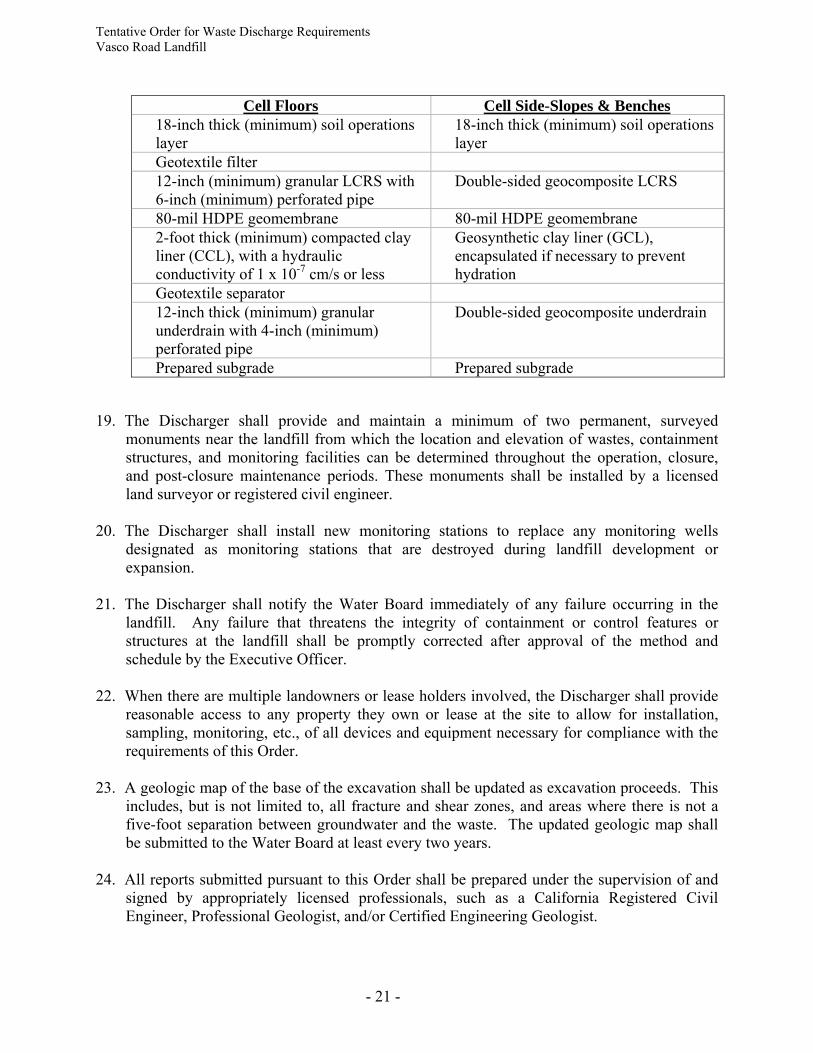
Tentative Order for Waste Discharge Requirements Vasco Road Landfill
- 21 -
Cell Floors Cell Side-Slopes & Benches 18-inch thick (minimum) soil operations
layer 18-inch thick (minimum) soil operations
layer Geotextile filter 12-inch (minimum) granular LCRS with
6-inch (minimum) perforated pipe Double-sided geocomposite LCRS
80-mil HDPE geomembrane 80-mil HDPE geomembrane 2-foot thick (minimum) compacted clay
liner (CCL), with a hydraulic conductivity of 1 x 10⁻⁷ cm/s or less
Geosynthetic clay liner (GCL), encapsulated if necessary to prevent hydration
Geotextile separator 12-inch thick (minimum) granular
underdrain with 4-inch (minimum) perforated pipe
Double-sided geocomposite underdrain
Prepared subgrade Prepared subgrade
19. The Discharger shall provide and maintain a minimum of two permanent, surveyed
monuments near the landfill from which the location and elevation of wastes, containment structures, and monitoring facilities can be determined throughout the operation, closure, and post-closure maintenance periods. These monuments shall be installed by a licensed land surveyor or registered civil engineer.
20. The Discharger shall install new monitoring stations to replace any monitoring wells
designated as monitoring stations that are destroyed during landfill development or expansion.
21. The Discharger shall notify the Water Board immediately of any failure occurring in the
landfill. Any failure that threatens the integrity of containment or control features or structures at the landfill shall be promptly corrected after approval of the method and schedule by the Executive Officer.
22. When there are multiple landowners or lease holders involved, the Discharger shall provide
reasonable access to any property they own or lease at the site to allow for installation, sampling, monitoring, etc., of all devices and equipment necessary for compliance with the requirements of this Order.
23. A geologic map of the base of the excavation shall be updated as excavation proceeds. This
includes, but is not limited to, all fracture and shear zones, and areas where there is not a five-foot separation between groundwater and the waste. The updated geologic map shall be submitted to the Water Board at least every two years.
24. All reports submitted pursuant to this Order shall be prepared under the supervision of and
signed by appropriately licensed professionals, such as a California Registered Civil Engineer, Professional Geologist, and/or Certified Engineering Geologist.
Tentative Order for Waste Discharge Requirements Vasco Road Landfill
- 22 -
25. All design aspects related to closure activities, e.g., closure design, final cover construction, shall be under the direct supervision of a registered civil engineer.
26. The Discharger shall notify the Water Board at least 180 calendar days prior to beginning any
final closure activities. C. PROVISIONS 1. Compliance: The Discharger shall comply immediately, or as prescribed by the time
schedule below, with all Prohibitions, Specifications, and Provisions of this Order. All required submittals must be acceptable to the Executive Officer. The Discharger must also comply with all conditions of these WDRs, including the SMP. Violations may result in enforcement actions, including Board orders or court orders requiring corrective action or imposing civil monetary liability, or in modification or revocation of these waste discharge requirements by the Regional Board. [CWC Sections 13261, 13263, 13265, 13267, 13268, 13300, 13301, 13304, 13340, and 13350].
2. Authority: All technical and monitoring reports required pursuant to this Order are being requested pursuant to Section 13267 of the California Water Code (CWC). Failure to submit reports in accordance with schedules established by this Order or failure to submit a report of sufficient technical quality acceptable to the Executive Officer may subject the Discharger to enforcement action pursuant to Section 13268 of the CWC.
3. Self-Monitoring Program: The Discharger shall implement and comply with the Self-Monitoring Program (SMP) attached to this Order and any revisions issued by the Executive Officer. The attached SMP is intended to constitute a Detection Monitoring Program (DMP) pursuant to Section 20420 of Title 27 and is designed to identify significant water quality impacts from the landfill and demonstrate compliance with the Water Quality Protection Standard (WQPS) established pursuant to Section 20390 of Title 27.
COMPLIANCE DATE: Immediate
4. Report of Waste Discharge (ROWD): The Discharger shall submit a technical report,
acceptable to the Executive Officer, describing any proposed material change in the character, location, or volume of a discharge, or in the event of a proposed change in use or development of the landfill [CWC Section 13260(c)]. The technical report shall describe the project, identify key changes to the design that may impact any portion of the landfill, and specify components of the design necessary to maintain integrity of the landfill cover and prevent water quality impacts. No material changes to any portion of the landfill shall be made without approval by the Executive Officer.
COMPLIANCE DATE: 120 days prior to any proposed material change
5. Construction-Related Storm Water Control Plans: For each proposed grading or
development project outside of the permitted landfill footprint greater than one acre in size, the Discharger shall submit a Notice of Intent to the State Board, submit a Storm Water Pollution Prevention Plan (SWPPP) acceptable to the Executive Officer, and implement Best Management Practices (BMPs) for the control of storm water, in accordance with
Tentative Order for Waste Discharge Requirements Vasco Road Landfill
- 23 -
requirements specified in the State Board’s General Permit for Storm Water Discharges Associated with Construction Activities (NPDES Permit No. CAS000001). The Discharger will be deemed in compliance with this Provision if another party constructing improvements on property owned by the Discharger, pursuant to an easement granted by the Discharger, has obtained coverage under the General Permit.
COMPLIANCE DATE: 30 days prior to construction
6. Well Installation or Destruction Report: The Discharger shall submit a technical report,
acceptable to the Executive Officer, that provides well construction details, geologic boring logs, and well development logs for all new wells installed or destroyed as part of the Discharge Monitoring Program (DMP).
COMPLIANCE DATE: 60 days following well installation or destruction
7. Earthquake Inspection: The Discharger shall submit a detailed Post-Earthquake Inspection
Report acceptable to the Executive Officer, in the event of any earthquake generating ground shaking of Richter Magnitude 7 or greater at or within 30 miles of the landfill. The report shall describe the containment features, groundwater monitoring, and control facilities potentially impacted by seismic deformations of any WMU. Damage to any waste containment facility that may impact waters of the State must be reported immediately to the Executive Officer.
COMPLIANCE DATE: Within 2 weeks of earthquake
8. Availability: A copy of these WDRs shall be maintained by the Discharger and shall be
made available by the Discharger to all employees or contractors performing work (maintenance, monitoring, repair, construction, etc.) at the landfill.
9. Change In Ownership: The Discharger must notify the Executive Officer in writing at least
30 days in advance of any proposed transfer or extension of this Order's responsibility and coverage to a new Discharger. The notice must include a written agreement between the existing Discharger and the new Discharger containing a specific date for the transfer of this Order's responsibility and coverage between the current Discharger and the new Discharger. This agreement shall include an acknowledgment of which Discharger is liable for violations up to the transfer date and which Discharger is liable from the transfer date on [CWC Sections 13267 and 13263].
10. Revision: These Waste Discharge Requirements (WDRs) are subject to review and revision
by the Water Board [CCR Section 13263]. 11. ROWD Reporting: When a Discharger becomes aware that it failed to submit any relevant
facts in a Report of Waste Discharge (ROWD) or submitted incorrect information in a ROWD or in any report to the Water Board, it shall promptly submit such facts or information [CWC Sections 13260 and 13267].
12. Vested Rights: This Order does not convey any property rights of any sort or any exclusive
privileges. The requirements prescribed herein do not authorize the commission of any act
Tentative Order for Waste Discharge Requirements Vasco Road Landfill
- 24 -
causing injury to persons or property, do not protect the Discharger from liability under Federal, State or local laws, nor do they create a vested right for the Discharger to continue the waste discharge [CWC Section 13263(g)].
13. Severability: Provisions of this Order are severable. If any provisions of these WDRs are
found invalid, the remainder of these requirements shall not be affected [CWC Section 9213].
14. Operation and Maintenance: The Discharger shall, at all times, properly operate and
maintain all facilities and systems of treatment and control (and related appurtenances) which are installed or used by the Discharger to achieve compliance with conditions of this Order. Proper operation and maintenance includes effective performance, adequate funding, adequate operator staffing and training, and adequate laboratory and process controls including appropriate quality assurance procedures. This provision requires the operation of backup or auxiliary facilities or similar systems only when necessary to achieve compliance with the conditions of this order [CWC Section 13263(f)].
15. Reporting of Hazardous Substance Release: If any hazardous substance is discharged in or
on any waters of the State, or discharged or deposited where it is, or probably will be, discharged in or on any waters of the State, the Discharger shall report such discharge to the Water Board by calling (510) 622-2300 during regular office hours (Monday through Friday, 8:00 a.m. to 5:00 p.m.). A written report shall be mailed or submitted electronically to the Water Board within 5 business days. The report shall describe: the nature of the hazardous substance, estimated quantity involved, duration of incident, cause of release, estimated size of affected area, nature of effect, corrective actions taken or planned, schedule of corrective actions planned, and persons/agencies notified.
16. Entry and Inspection: The Discharger shall allow the Water Board, or an authorized
representative upon the presentation of credentials and other documents as may be required by law, to: (a) enter upon the Discharger's premises where a regulated facility or activity is located or
conducted, or where records must be kept under the conditions of this Order; (b) have access to and copy, at reasonable times, any records that must be kept under the
conditions of this Order; (c) inspect at reasonable times any facilities, equipment (including monitoring and control
equipment), practices, or operations regulated or required under this Order; and (d) sample or monitor at reasonable times, for the purposes of assuring compliance with
this Order or as otherwise authorized by the California Water Code, any substances or parameters at any location [CWC Section 13267].
17. Discharges To Navigable Waters: Any person discharging or proposing to discharge to
navigable waters from a point source (except for discharge of dredged or fill material subject to Section 404 of the Clean Water Act and discharge subject to a general NPDES permit) must file an NPDES permit application with the Water Board [CCR Title 2 Section 223571].
18. Endangerment of Human Health or the Environment: The Discharger shall report any event
of noncompliance that may endanger human health or the environment. Any such
Tentative Order for Waste Discharge Requirements Vasco Road Landfill
- 25 -
information shall be provided orally to the Executive Officer, or an authorized representative, within 24 hours from the time the Discharger becomes aware of the circumstances by calling (510) 622-2300 during regular office hours (Monday through Friday, 8:00 a.m. to 5:00 p.m.). A written submission to the Water Board shall also be provided within 5 days of the time a Discharger becomes aware of the circumstances. The written submission shall contain a description of the noncompliance and its cause; the period of noncompliance, including exact dates and times, and if the noncompliance has not been corrected; the anticipated time it is expected to continue and steps taken or planned to reduce, eliminate, and prevent recurrence of the noncompliance. The Executive Officer, or an authorized representative, may waive the written report on a case-by-case basis if the oral report has been received within 24 hours.
19. Document Distribution: Copies of all correspondence, technical reports, and other documents pertaining to compliance with this Order shall be provided to the following agencies:
(a) California Regional Water Quality Control Board, San Francisco Bay Region (b) Alameda County Department of Environmental Health (Local Enforcement Agency).
The Executive Officer may modify this distribution list as needed. 20. Duty to Comply: The Discharger shall comply immediately, or as prescribed by the time
schedule below, with all Prohibitions, Specifications, and Provisions of this Order. All required submittals must be acceptable to the Executive Officer. The Discharger must also comply with all conditions of these WDRs. Violations may result in enforcement actions, including Water Board orders or court orders requiring corrective action or imposing civil monetary liability, or in modification or revocation of these WDRs by the Water Board. (CWC Sections 13261, 13263, 13265, 13268, 13300, 13301, 13304, 13340, 13350).
21. Requests for Technical Reports: All technical and monitoring reports required by this Order
are requested pursuant to Section 13267 of the California Water Code. Failure to submit reports in accordance with schedules established by this Order or failure to submit a report of sufficient technical quality acceptable to the Executive Officer may subject the Discharger to enforcement action pursuant to Section 13268 of the CWC.
22. Reporting Requirements: (a) Hardcopies:
1. Technical reports/plans, submitted by the Discharger, in compliance with the Prohibitions, Specifications, and Provisions of this Order, shall be submitted to the Water Board on the schedule specified herein. Hard copies of these reports/plans shall consist of a letter report that includes the following:
a. Identification of any obstacles that may threaten compliance with the schedule; b. In the event of non-compliance with any Prohibition, Specification or Provision of
this Order, written notification which clarifies the reasons for non-compliance and which proposes specific measures and a schedule to achieve compliance. This written notification shall identify work not completed that was projected for
Tentative Order for Waste Discharge Requirements Vasco Road Landfill
- 26 -
completion, and shall identify the impact of non-compliance on achieving compliance with the remaining requirements of this Order;
c. In the self-monitoring reports, an evaluation of the current groundwater monitoring system and a proposal for modifications as appropriate; and
d. A signed transmittal letter and professional certification by a California Licensed Civil Engineer or a Professional Geologist
2. All application reports or information to be submitted to the Executive Officer shall
be signed and certified as follows:
a. For a corporation – by a principle executive officer or the level of vice-president or an appropriate delegate.
b. or a partnership or sole proprietorship – by a general partner or the proprietor, respectively.
c. For a municipality, state, federal, or other public agency – by either a principal executive officer or ranking elected official.
(b) Electronic Submittals:
1. The State Board has adopted regulations requiring electronic report and data submittal to Geotracker [http://www.geotracker.swrcb.ca.gov/]. The text of the regulations can be found at the following link: http://www.waterboards.ca.gov/ust/cleanup/electronic_reporting/docs/final_electronic_regs_dec04.pdf
2. The Discharger is responsible for submitting the following via the internet:
a. Groundwater analytical data; b. Surveyed locations of monitoring wells; c. Boring logs describing monitoring well construction; and d. Portable data format (PDF) copies of all reports identified in 1 and 2 above (the
document, in its entirety [signature pages, text, figures, tables, etc.] must be saved to a single PDF file).
e. Copies of all correspondence, reports, and documents pertaining to compliance with the Prohibitions, Specifications, and Provisions of this Order related to storm water and compliance with the State Board General Permit No. CAS000001 for the Discharge of Storm Water Associated with Industrial Activities
3. Upon request, monitoring results shall also be provided electronically in Microsoft
Excel® to allow for ease of review of site data, and to facilitate data computations and/or plotting that Water Board staff may undertake during the review process. Data tables submitted in electronic spreadsheet format will not be included in the case of file review and should therefore be submitted on CD and included with the hard copy of the report. Electronic tables shall include the following information:
a. Well designations; b. Well location coordinates (latitude and longitude);
Tentative Order for Waste Discharge Requirements Vasco Road Landfill
- 27 -
c. Well construction (including top of well casing elevation, total well depth, screen interval depth below ground surface, screen interval elevation, and a characterization of geology of subsurface the well is located in);
d. Groundwater depths and elevations (water levels); e. Current analytical results by constituent of concern (including detection limits
for each constituent); f. Historical analytical results (including the past five years, unless otherwise
requested); and g. Measurement dates.
23. This Order supersedes and rescinds Order No. 96-041. I, Bruce H. Wolfe, Executive Officer, do hereby certify that the foregoing is a full, complete, and correct copy of an Order adopted by the California Regional Water Quality Control Board, San Francisco Bay Region, on August 13, 2008.
___________________ Bruce H. Wolfe Executive Officer Attachments: Figure 1 – Site Location Map
Figure 2 – Site Plan Figure 3 – Final Grading Plan Figure 4 – Closure Schedule Plan Figure 5 - Monitoring Locations Self Monitoring Program (Part A and Part B)
Tentative Order for Waste Discharge Requirements Vasco Road Landfill
- 28 -
Tentative Order for Waste Discharge Requirements Vasco Road Landfill
- 29 -
Tentative Order for Waste Discharge Requirements Vasco Road Landfill
- 30 -
Tentative Order for Waste Discharge Requirements Vasco Road Landfill
- 31 -
Tentative Order for Waste Discharge Requirements Vasco Road Landfill
- 32 -
Tentative Order for Waste Discharge Requirements Vasco Road Landfill
- 33 -
CALIFORNIA REGIONAL WATER QUALITY CONTROL BOARD SAN FRANCISCO BAY REGION
SELF-MONITORING PROGRAM
FOR
REPUBLIC SERVICES, INC., REPUBLIC SERVICES VASCO ROAD, LLC.
VASCO ROAD LANDFILL,
CLASS III SOLID WASTE DISPOSAL SITE LIVERMORE, ALAMEDA COUNTY
ORDER No. ----
CONSISTS OF
PART A
AND
PART B
Tentative Order for Waste Discharge Requirements Vasco Road Landfill
- 34 -
PART A This Self-Monitoring Program (SMP) specifies monitoring and reporting requirements, including:
(a) general monitoring requirements for landfills and waste management units (Part A) (b) self-monitoring report content and format (Part A) (c) self-monitoring report submittal frequency and schedule (Part B) (d) monitoring locations and frequency (Part B) (e) monitoring parameters and analytes (Part B).
A. AUTHORITY AND PURPOSE
For discharges of waste to land, water quality monitoring is required pursuant to the California Code of Regulations (CCR), Division 2, Title 27, Subdivision 1, Chapter 3, Subchapter 3, Sections 20380 through 20435. The principal purposes of an SMP are: (1) to document compliance with waste discharge requirements (WDRs) and prohibitions established by the Water Board, (2) to facilitate self-policing by the waste Discharger in the prevention and abatement of pollution arising from the waste discharge, (3) to develop or assist in the development of effluent standards of performance and toxicity standards, and (4) to assist the Discharger in complying with the requirements of Title 27.
B. MONITORING REQUIREMENTS
Monitoring refers to the observation, inspection, measurement, and/or sampling of environmental media, waste management units (WMUs), containment and control facilities, and waste disposed in each WMU. The following defines the types of monitoring that may be required. Monitoring of Environmental Media The Water Board may require monitoring of groundwater, surface water, vadose zone, storm water, leachate, landfill gas and any other environmental media that may pose a threat to water quality or provide an indication of a water quality threat at the site. Sample collection, storage, and analyses shall be performed according to the most recent version of EPA-approved methods or in accordance with a sampling and analysis plan (SAP) approved by Water Board staff. Analytical testing of environmental media required by this SMP shall be performed by a California State-approved laboratory for the required analyses. The director of the laboratory whose name appears on the certification shall be responsible for supervising all analytical work in his/her laboratory and shall have signing authority for all reports or may designate signing of all such work submitted to the Water Board. All monitoring instruments and devices used to conduct monitoring in accordance with this SMP shall be maintained and calibrated as necessary to ensure their continued accuracy. All flow measurement devices shall be calibrated at least once every two years.
Tentative Order for Waste Discharge Requirements Vasco Road Landfill
- 35 -
Receiving waters refer to any surface water which actually or potentially receives surface or groundwater that pass over, through, or under waste materials or impacted soils. In this case, the groundwater beneath and adjacent to the landfill areas and the surface run-off from the site are considered receiving waters. Standard Observations Standard observations refer to observations within the limits of each WMU, at their perimeter, and of the receiving waters beyond their limits. Standard observations include: 1. WMUs:
a. evidence of ponded water at any point on the WMU; b. evidence of odors, including their presence or absence, characterization, source, and
distance of travel from source; and c. evidence of erosion and/or daylighted waste.
2. Perimeter of WMUs:
a. evidence of liquid leaving or entering the WMU, estimated size of affected area and flow rate (show affected area on map);
b. evidence of odors, including their presence or absence, characterization, source, and distance of travel from source; and
c. evidence of erosion and/or daylighted waste. 3. Receiving Waters:
a. floating and suspended materials of waste origin, including their presence or absence, source, and size of affected area;
b. discoloration and turbidity: description of color, source, and size of affected area; c. evidence of odors, presence or absence, characterization, source, and distance of travel
form source; d. evidence of beneficial use, such as presence of water associated with wildlife; e. estimated flow rate; and f. weather conditions, such as estimated wind direction and velocity, total precipitation.
Facilities Inspections Facilities inspections refer to the inspection of all containment and control structures and devices associated with the landfill. Containment and control facilities may include the following: 1. intermediate and final covers; 2. storm-water management system (SWMS) elements such as perimeter drainage and diversion
channels, ditches and downchutes, and detention and sedimentation ponds or collection tanks;
3. landfill gas system; and 4. leachate collection and recovery system (LCRS) elements such as leachate storage tanks,
pumps and control equipment.
Tentative Order for Waste Discharge Requirements Vasco Road Landfill
- 36 -
Quality Assurance/Quality Control (QA/QC) Sample Monitoring The Discharger shall collect duplicate, field blank, equipment blank (if appropriate) and trip blank samples for each semiannual monitoring event at the following frequencies:
1. duplicate sample – one sample per 20 regular samples; 2. field blank – one per semiannual monitoring event; 3. equipment blank – one sample per 10 monitoring stations; and 4. trip blank – one sample per cooler. Waste Monitoring Waste monitoring shall consist of recording on a monthly basis the following: 1. the weight of waste disposed at the site during the month (i.e., municipal solid waste (MSW),
construction and demolition waste, and industrial waste, including (i) asbestos, (ii) ash, (iii) treated auto shredder waste, (iv) petroleum contaminated soils, (v) lead-contaminated soils, (vi) sewage and wastewater treatment sludges with metal content, (vii) industrial sludges, and (viii) industrial filters);
2. remaining landfill capacity/waste volume in place; and 3. locations and dimensions of the fill areas on the map. Leachate Monitoring Landfill leachate shall be removed daily from the leachate collection sumps to the lowest practical level by dedicated automated leachate pumps. The LCRS shall be inspected daily. Leachate removed from the LCRS shall be transported for disposal at a wastewater treatment plant or re-injected to a Subtitle D-compliant disposal unit. The Discharger shall record on a weekly basis the estimated volume of removed leachate and report the method of leachate disposal. Landfill Gas Condensate Monitoring Landfill gas condensate removed from the landfill gas collection system shall be transported for disposal at a wastewater treatment plant or re-injected to a Subtitle D-compliant disposal unit. The Discharger shall record on a weekly basis the estimated volume of removed landfill gas condensate and report the method of condensate disposal. C. REPORTING REQUIREMENTS
Reporting responsibilities of waste dischargers are specified in Sections 13225(a), 13267(b), 13383, and 13387(b) of the California Code of Regulations (CCR) and this Water Board's Resolution No.73-16 and Order No. 93-113. At a minimum, each Self Monitoring Report (SMR) shall include the following information: 1. Transmittal Letter: A cover letter transmitting the essential points of the monitoring report
shall be included with each monitoring report. The transmittal letter shall discuss any violations during the reporting period and actions taken or planned to correct the problem.
Tentative Order for Waste Discharge Requirements Vasco Road Landfill
- 37 -
The letter shall also certify the completion of all monitoring requirements. The letter shall be signed by the Discharger's principal executive officer or his/her duly authorized representative, and shall include a statement by the official, under penalty of perjury, that the report is true and correct to the best of the official's knowledge.
2. Graphic Presentation: The following maps, figures, and graphs (if applicable) shall be
included in each SMR to visually present data collected pursuant to this SMP:
a. plan-view maps showing all monitoring and sampling locations, waste management units, containment and control structures, treatment facilities, surface water bodies, and site/property boundaries;
b. groundwater level/piezometric surface contour maps for each groundwater-bearing zone of interest showing inferred groundwater gradients and flow directions under/around each WMU, based upon the past and present water level elevations and pertinent visual observations; and
c. any other maps, figures, photographs, cross-sections, graphs, and charts necessary to visually demonstrate the appropriateness and effectiveness of sampling, monitoring, characterization, investigation, or remediation activities relative to the goals of this SMP.
3. Tabular Presentation: The following data (if applicable) shall be presented in tabular form
and included in each SMR to show a chronological history and allow quick and easy reference:
a. well designation; b. well location coordinates (latitude and longitude); c. well construction (including top of well casing elevation, total well depth, screen interval
depth below ground surface, and screen interval elevation); d. groundwater depths; e. groundwater elevations; f. current analytical results (including analytical method and detection limits for each
constituent); g. historical analytical results (including at least the past five years unless otherwise
requested); and h. measurement dates.
4. Compliance Evaluation Summary and Discussion:
a. a summary and certification of completion of all environmental media monitoring, standard observations, and facilities inspections;
b. the quantity and types of wastes disposed of during the past quarter, and the locations of the disposal operations, if applicable;
c. a description of the waste stream including the percentage of each waste type (e.g., residential, commercial, industrial, construction/demolition, etc.), if applicable;
d. the signature of the laboratory director or his/her designee indicating that he/she has supervised all analytical work in his/her laboratory; and
e. provide a discussion of the field and laboratory results that includes the following information:
Tentative Order for Waste Discharge Requirements Vasco Road Landfill
- 38 -
(1) data interpretations (2) conclusions (3) recommendations (4) newly implemented or planned investigations and remedial measures (5) data anomalies (6) variations from protocols (7) condition of wells (8) effectiveness of leachate monitoring and control facilities.
5. Appendices: The following information shall be provided as appendices in electronic format
only unless requested otherwise by Water Board staff and unless the information is already contained in a SAP approved by Water Board staff:
a. new boring and well logs; b. method and time of water level measurements; c. purging methods and results including the type of pump used, pump placement in the
well, pumping rate, equipment and methods used to monitor field pH, temperature, and electrical conductivity, calibration of the field equipment, pH temperature, conductivity, and turbidity measurements, and method of disposing of the purge water;
d. sampling procedures, field, equipment, and travel blanks, number and description of duplicate samples, type of sample containers and preservatives used, the date and time of sampling, the name of the person actually taking the samples, and any other relevant observations; and
e. documentation of laboratory results, analytical methods, detection limits (DLs) and reporting limits (RLs), and Quality Assurance/Quality Control (QA/QC) procedures for the required sampling.
D. CONTINGENCY REPORTING
1. The Discharger shall report to the Water Board by telephone (510-622-2300, Monday
through Friday, 8 a.m to 5 p.m.) any significant discharge from the disposal area immediately after it is discovered. The Discharger shall submit a written report with the Water Board within five days of discovery of any discharge. The written report shall contain the following information:
a. a map showing the location(s) of discharge; b. approximate flow rate; c. nature of effects (e.g., all pertinent observations and analyses); and d. corrective measures underway or proposed.
2. The Discharger shall submit a written report to the Water Board within seven days of
determining that a statistically significant difference occurred between a SMP sample set and an approved Water Quality Protection Standard (WQPS). The written report shall indicate which WQPS(s) have been exceeded. If appropriate, the Discharger shall resample at the compliance point(s) where this difference has been found within 30 days.
Tentative Order for Waste Discharge Requirements Vasco Road Landfill
- 39 -
3. If re-sampling and analysis confirms the earlier finding of a statistically significant difference between SMP results and WQPS(s), the Discharger shall, upon determination by the Executive Officer, submit to the Water Board an amended Report of Waste Discharge (ROWD) as specified in Section 20420 of Title 27 for establishment of an Evaluation Monitoring Program (EMP) meeting the requirements of Section 20425 of Title 27.
E. REPORTING REQUIREMENTS The Discharger shall submit SMRs to Water Board staff in accordance with the schedule indicated in Table B-4. Reports due at the same time maybe combined into one report for convenience, as long as monitoring activities and results pertaining to each monitoring period are clearly distinguishable. Reports shall be submitted in accordance with Provision C.22 in the WDRs. F. MAINTENANCE OF WRITTEN RECORDS The Discharger shall maintain information required pursuant to this SMP for at least five years. The five-year period of retention shall be extended during the course of any unresolved litigation regarding a discharge or when requested by the Water Board.
Tentative Order for Waste Discharge Requirements Vasco Road Landfill
- 40 -
PART B
A. MONITORING LOCATIONS AND FREQUENCY Monitoring locations, frequencies, parameters, and analytes are specified in Tables B-1, B-2, and B-3 of this SMP and as indicated below. Monitoring locations are shown in Figure B-1. 1. Environmental Media
a. Groundwater:
Groundwater shall be monitored at the locations specified in Table B-1 and shown on Figure B-1. Monitoring frequencies, parameters, and analytes shall be in accordance with Table B-1.
b. Leachate:
Leachate shall be monitored at the locations specified in Table B-1 and shown on Figure
B-1. Monitoring frequencies, parameters, and analytes shall be in accordance with Table B-1.
c. Storm Water:
Stormwater shall be monitored at the locations specified in Table B-1 and shown on
Figure B-1. Monitoring parameters and analytes shall be in accordance with Table B-1.
Surface-water stations SR-1 and SR-2 shall be sampled monthly during landfill working hours if water is present from 15 October through 15 April. Samples are to be collected within 2 hours of the beginning of the first storm or as soon as sufficient water is available for sampling. Between April 16 and October 14, stations SR-1 and SR-2 shall be sampled quarterly if water is present during landfill working hours.
2. Standard Observations Standard observations shall be made within each WMU, along the perimeter of each WMU,
and of the water courses and receiving waters beyond their limits. Standard observations shall be conducted at the frequency specified in Table B-2 and at the following locations:
a. “V” stations – located on the waste disposal area as delineated by an approximately 500-
foot grid network; and b. “P” stations – located at equidistant intervals not exceeding 1,000 ft around the perimeter
of the waste area.
A map, showing visual (V) and perimeter (P) compliance points, shall be included in the SMRs.
Tentative Order for Waste Discharge Requirements Vasco Road Landfill
- 41 -
3. Facilities Inspections The Discharger shall inspect all containment and control structures and devices associated
with the landfill to ensure proper and safe operation. Facility inspections shall be conducted at the locations and frequencies specified in Table B-3.
4. Quality Assurance/Quality Control Samples
The QA/QC samples shall be analyzed for VOCs (field blank, equipment blank and trip blank) or for same tests as a regular sample (duplicate sample).
B. REPORTING SCHEDULE The Discharger shall submit SMRs to Water Board staff in accordance with the schedule indicated in Table B-4. Reports due at the same time maybe combined into one report for convenience, as long as monitoring activities and results pertaining to each monitoring period are clearly distinguishable. Attachments: SMP Tables B-1, B-2, B-3 and B-4
SMP Figure B-1
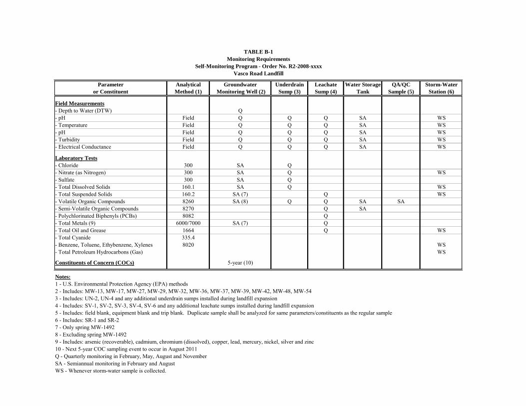
Parameter Analytical Groundwater Underdrain Leachate Water Storage QA/QC Storm-Wateror Constituent Method (1) Monitoring Well (2) Sump (3) Sump (4) Tank Sample (5) Station (6)
Field Measurements- Depth to Water (DTW) Q- pH Field Q Q Q SA WS- Temperature Field Q Q Q SA WS- pH Field Q Q Q SA WS- Turbidity Field Q Q Q SA WS- Electrical Conductance Field Q Q Q SA WS
Laboratory Tests- Chloride 300 SA Q- Nitrate (as Nitrogen) 300 SA Q WS- Sulfate 300 SA Q- Total Dissolved Solids 160.1 SA Q WS- Total Suspended Solids 160.2 SA (7) Q WS- Volatile Organic Compounds 8260 SA (8) Q Q SA SA- Semi-Volatile Organic Compounds 8270 Q SA- Polychlorinated Biphenyls (PCBs) 8082 Q- Total Metals (9) 6000/7000 SA (7) Q- Total Oil and Grease 1664 Q WS- Total Cyanide 335.4- Benzene, Toluene, Ethybenzene, Xylenes 8020 WS- Total Petroleum Hydrocarbons (Gas) WS
Constituents of Concern (COCs) 5-year (10)
Notes:1 - U.S. Environmental Protection Agency (EPA) methods2 - Includes: MW-13, MW-17, MW-27, MW-29, MW-32, MW-36, MW-37, MW-39, MW-42, MW-48, MW-543 - Includes: UN-2, UN-4 and any additional underdrain sumps installed during landfill expansion4 - Includes: SV-1, SV-2, SV-3, SV-4, SV-6 and any additional leachate sumps installed during landfill expansion 5 - Includes: field blank, equipment blank and trip blank. Duplicate sample shall be analyzed for same parameters/constituents as the regular sample6 - Includes: SR-1 and SR-27 - Only spring MW-14928 - Excluding spring MW-14929 - Includes: arsenic (recoverable), cadmium, chromium (dissolved), copper, lead, mercury, nickel, silver and zinc10 - Next 5-year COC sampling event to occur in August 2011Q - Quarterly monitoring in February, May, August and NovemberSA - Semiannual monitoring in February and AugustWS - Whenever storm-water sample is collected.
TABLE B-1
Self-Monitoring Program - Order No. R2-2008-xxxxVasco Road Landfill
Monitoring Requirements
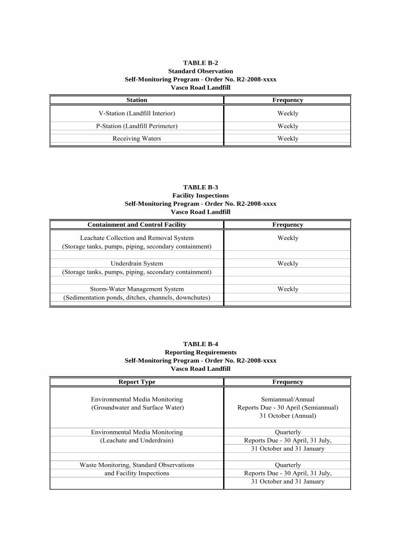
Station Frequency
V-Station (Landfill Interior) Weekly
P-Station (Landfill Perimeter) Weekly
Receiving Waters Weekly
Containment and Control Facility Frequency
Leachate Collection and Removal System Weekly(Storage tanks, pumps, piping, secondary containment)
Underdrain System Weekly(Storage tanks, pumps, piping, secondary containment)
Storm-Water Management System Weekly(Sedimentation ponds, ditches, channels, downchutes)
Report Type Frequency
Environmental Media Monitoring Semiannual/Annual (Groundwater and Surface Water) Reports Due - 30 April (Semiannual)
31 October (Annual)
Environmental Media Monitoring Quarterly(Leachate and Underdrain) Reports Due - 30 April, 31 July,
31 October and 31 January
Waste Monitoring, Standard Observations Quarterlyand Facility Inspections Reports Due - 30 April, 31 July,
31 October and 31 January
TABLE B-4Reporting Requirements
Self-Monitoring Program - Order No. R2-2008-xxxxVasco Road Landfill
TABLE B-3Facility Inspections
Self-Monitoring Program - Order No. R2-2008-xxxxVasco Road Landfill
TABLE B-2
Self-Monitoring Program - Order No. R2-2008-xxxxVasco Road Landfill
Standard Observation
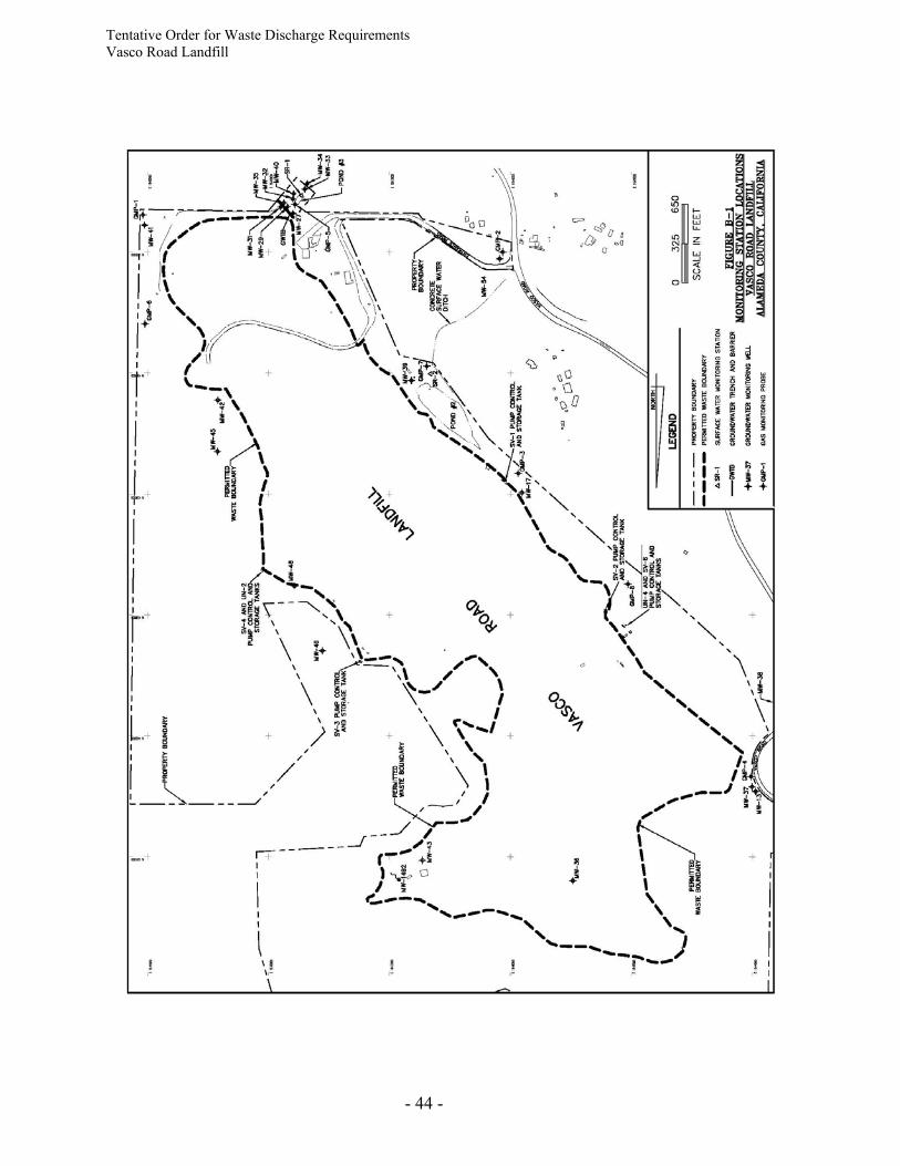
Tentative Order for Waste Discharge Requirements Vasco Road Landfill
- 44 -