Embed Size (px)
Citation preview

Terrestrial Water and Carbon Cycle Changes over Northern Eurasia: Past and future
Dennis P. Lettenmaiera
Theodore C. Bohnb
aUniversity of California, Los AngelesbArizona State University
NEESPI Synthesis Workshop
Prague
Apr 9, 2015
2
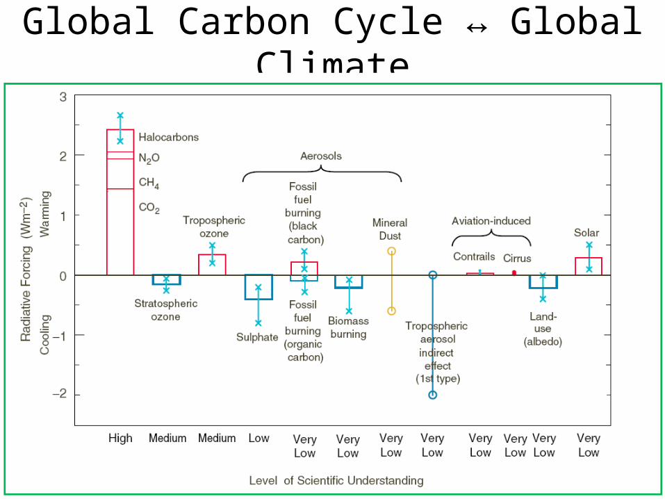
Global Carbon Cycle ↔ Global Climate
(IPCC, 2001)
Increases in global mean radiative forcing over period 1750 to 2000 A.D.
Almost 1% of incoming solar energy
But CH4 is pretty bad too= 20% of greenhouse gas forcing
CO2 has a bad reputation= 60% of greenhouse gas forcing
Both CO2 and CH4 are part of the global carbon cycle
CH4 is a MUCH stronger greenhouse gas than CO2

3
Importance of Wetlands
Lehner and Doll, 2004
West Siberian Lowland(WSL)
Wetlands:•Largest natural global source of CH4
•Large C sink
High latitudes experiencing pronounced climate change
Wetland carbon emissions are sensitive to climate
50% of world’s wetlands are at high latitudes
Potential positive feedback to warming climate
4
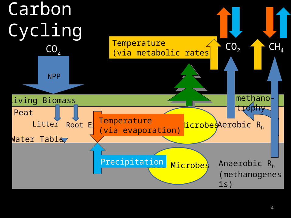
Carbon Cycling
Water Table
Living Biomass
Peat
Aerobic Rh
CO2
Anaerobic Rh (methanogenesis)
CH4Temperature(via metabolic rates)
NPP
CO2
Soil Microbes
Soil Microbes
Precipitation
methano-trophy
Litter Root ExudatesTemperature(via evaporation)

5
Effects of Microtopography•Water table variations on the scale of meters•Saturated soil inhibits NPP and Rh; promotes CH4•Areas vary seasonally
Inundated
Saturated Fraction Unsaturated Fraction

6
Heterogeneity Ignored at Large Scale: 1. Moisture
Color-By-Numbers: constant emissions assigned to various land cover types (e.g., Fung et al., 1991).
Uniform Water Table: Entire grid cell has the same water table depth (e.g., Zhuang et al., 2004; most other land surface models).•Does not require information about microtopography•Cannot be compared to remote sensing
Wet-Dry: CH4 only emitted by inundated or saturated fraction (e.g., Ringeval et al., 2010).•Can be calibrated to match remote sensing•Ignores CH4 from unsaturated fraction
CH4
CH4
CH4
Do these simplifications lead to biases? What do biases depend on?

7
Modeling Framework
• VIC hydrology model– Large, “flat” grid cells (e.g.
100x100 km)– On hourly time step, simulate:
• Soil T profile• Water table depth ZWT• NPP• Soil Respiration• Other hydrologic variables…
• Link to CH4 emissions model (Walter & Heimann 2000)
First attempt at water table distribution: TOPMODEL (Beven and Kirkby, 1979)

8
New Model Formulation• Use VIC dynamic
lake/wetland model (Bowling and Lettenmaier, 2010)
• Topo. information from 1-km DEM NOT a good predictor of water table depth
• Added water table distribution due to microtopography
• Not considering lake C cycle

9
Response to Future Climate Change
Questions:• How will WSL wetland carbon fluxes respond
to possible end-of-century climate?• Which mechanisms will dominate the
response?

10
CMIP5 Model Projections, WSLRCP 4.5 Scenario; 2071-2100 compared to 1981-2010
• T-induced water table drawdown• Will P compensate?• T-induced increase in metabolic ratesEffect: possible increase or decrease in CH4

Current and Future Climate Controls on Pan-Arctic Methane Emissions
Over 1960-2006:CH4 emissions increased by 20%Temperature was the dominant factor

Dominant Drivers
Simulations over 1960-2006
Correlation with CRU Summer TairBlue to Yellow: +1 to -1
Correlation with UDel Summer PGreen to Red: +1 to -1
Blue = CH4 is temperature-limitedRed = CH4 is water-limited
Over most of domain, CH4 emissions are temperature-limited
But water-limited in South

Future Emissions
Emissions will increase by 42% between 2000s and 2090s
Temperature is dominant driver again
But emissions increase less rapidly after 2050

Future Roles of Drivers
2000s 2090s
• Warming over next 85 years leads to expansion of water-limited zone• Further increases in temperature have relatively little effect• Emissions become driven by precipitation

CH4 Emissions depend strongly on vegetation
• Temperature dependence (Q10) (Lupascu et al., 2012):– higher in sphagnum moss-dominated wetlands– lower in sedge-dominated wetlands
• Plant-aided transport (Walter and Heimann, 2000):– High in sedge-dominated wetlands– Low in shrubby/treed wetlands– 0 in sphagnum moss-dominated wetlands

Wetland vegetation controlled by climate
Peregon et al. (2008)
Taiga:Trees presentLarge expanses of Sphagnum-dominated “uplands” (bogs)Sedges in wet depressions (fens)
Sub-Taiga and Forest-Steppe:• Few Trees• Wetlands primarily occupy
depressions• Primarily sedge-dominated
Tundra and Forest-Tundra:• Few trees• Permafrost (ice lenses)
influences microtopography• Sedges in wet depressions

Northward Veg. ShiftSouthern biomes will migrate northward over next century (Kaplan and New, 2006)
– Forest will displace tundra– General increase in LAI
17
Change in LAI, 1900 to 2100(Alo and Wang, 2008)
Possible Effects:• Higher LAI = Higher NPP =
Increase in CH4• Higher LAI = Greater ET,
Drying of soil = Decrease in CH4

SimulationsSimulation N Climate (T,P) Soil Moisture LAI
Historical 1 Adam et al. (2006)
Prognostic MODIS (Myneni et al., 2002)
Warming+Drying+LAI 32 CMIP5 Prognostic CMIP5
Warming+Drying 32 CMIP5 Prognostic MODIS
Warming+LAI 1 CMIP5 EnsMean
Prescribed CMIP5
Warming 1 CMIP5 EnsMean
Prescribed MODIS
18
Case Acclimatization
NoAcc No
Acc Yes
Microbial Response Cases
Changes in Species Abundances Not Yet Finished
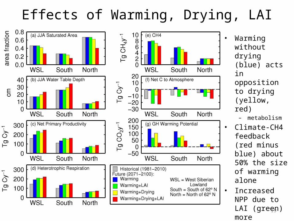
Effects of Warming, Drying, LAI• Warming without
drying (blue) acts in opposition to drying (yellow, red)
– metabolism
• Climate-CH4 feedback (red minus blue) about 50% the size of warming alone
• Increased NPP due to LAI (green) more important than drying for Net C fluxes
19

Some thoughts on post-NEESPI directions
1) Constraining models with observations:Need “benchmarks” with comprehensive observations –
continued focus on WSL, revisit observation suites2) Long-term observations:
Need long-term (multi-year) observations at relatively small number of representative sites, to help identify which drivers dominate wetland fluxes over time
Soil temperature Water table position CH4 emissions
Monitoring of disturbed (burned or drained) sites before/after disturbance (paired sites as feasible)

Future directions (cont.)3) Spatial heterogeneity (intensive but not necessarily continuing)
Need intensive sampling of many points at each wetland “site”, sampling along the gradient of microtopography (hummocks/ridges to hollows) – perhaps a 50-m transect,intervals of 1 m:
Soil surface elevation Water table position Soil temperature profile CH4 emissions – chamber and flux tower
These samplings need to happen at, for example, weekly intervals over a growing season Ideally, do this at several sites in a 10x10-km region (within same larger wetland complex, for example Bakchar Bog), to also capture regional water table gradients

Future directions (cont.)4) Spatio-temporal changes:
Monitoring of thermokarst (actively changing) sites – both multi-year and spatially intensive
Vegetation Microtopography Water table position Soil temperatures CH4 emissions Role of Remote Sensing:
Inundation and saturation products (e.g. passive microwave – AMSR) and radar (e.g., PALSAR); role of SMAP to be determined) Model development (and testing): Better representation of interactions between nitrogen, carbon, and water
cycles Dynamic peat models (like LPJ-MPI) to investigate rates of peat
accumulation and loss (and effects on hydrology) Better representation of lake carbon cycling, DOC transport (role of
SWOT?)


Other Veg Changes
Warming/Drying:• Lower water tables may reduce areas of
sedge-dominated depressions– Additional reduction in CH4 emissions
• Encroachment of shrubs and trees into sphagnum-dominated bogs in Taiga zone– Small increase in plant-aided transport?– Replacement of wetlands with forest?

Microbial ResponsesAcclimatization (Koven et al., 2011)• Microbes adapt to new T• Poorly understood
25
CH4
Time
T
Effect: smaller (or no) increase in CH4 emissions

Simulations – Handling of Climate and LAI• T, P: delta method, applied to 1980-2010• CO2: CMIP5 ensemble mean• LAI: quantile-mapping, applied to MODIS
26
CMIP5 whole-gridcell LAI vs. MODIS LAI for just wetland

Simulations – Handling of Microbial Response
• Acclimatization: Tmean = 10-year moving average soil temperature
27
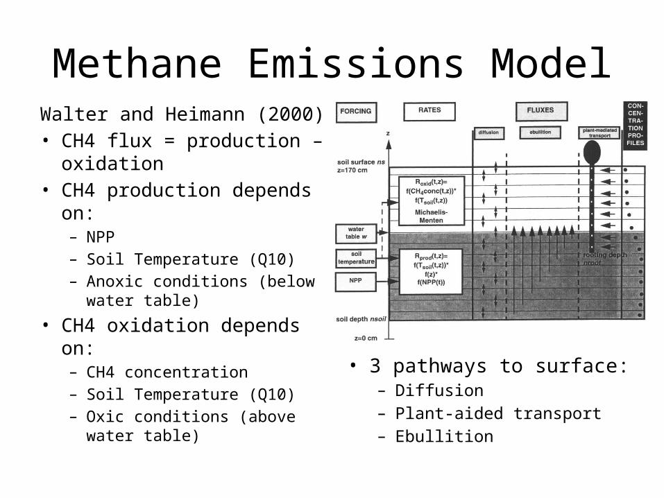
Methane Emissions ModelWalter and Heimann (2000)• CH4 flux = production –
oxidation• CH4 production depends on:
– NPP– Soil Temperature (Q10)– Anoxic conditions (below
water table)
• CH4 oxidation depends on:– CH4 concentration– Soil Temperature (Q10)– Oxic conditions (above water
table)
• 3 pathways to surface:– Diffusion– Plant-aided transport– Ebullition