Embed Size (px)
Citation preview
The Nature Conservancy Skagit Field Office, Washington Chapter
Fisher Slough Final Design and Permitting TESC Plan Skagit County, WA November 2009 Prepared by: David Cline, P.E., Jon Olmsted, P.E.
In association with:
INCA Engineers Moffatt & Nichol URS Corporation Miller Consulting
1420 5th Ave, Suite 550 Seattle, WA 98101

This page intentionally left blank.

The Nature Conservancy DRAFT TESC Plan Fisher Slough – Final Design and Permitting
i November 2009
Disclaimer These documents have been prepared for a specific project and shall neither be altered nor reused for any other purpose. Also, these documents do not represent as-built conditions. If these documents are altered intentionally or unintentionally, or reused without the design engineer’s written approval, it will be at the sole risk and responsibility of the user. The act of altering or reusing is construed as indemnifying and holding the design engineering firm and its employees harmless from all claims, damages, and expenses, including attorney fees, arising out of such act.

The Nature Conservancy DRAFT TESC Plan Fisher Slough – Final Design and Permitting
ii November 2009
This page intentionally left blank.
The Nature Conservancy DRAFT TESC Plan Fisher Slough – Final Design and Permitting
iii November 2009
Points of Contact
Jenny Baker Fisher Slough Project Manager 410 N 4th Street Mt. Vernon, WA 98273 Phone: 360.419.7022 Email: [email protected] Kevin Morse Skagit Delta Project Manager 410 N 4th Street Mt. Vernon, WA 98273 Phone: 360.419.0131 Email: [email protected]

The Nature Conservancy DRAFT TESC Plan Fisher Slough – Final Design and Permitting
iv November 2009
The Nature Conservancy DRAFT TESC Plan Fisher Slough – Final Design and Permitting
1 November 2009
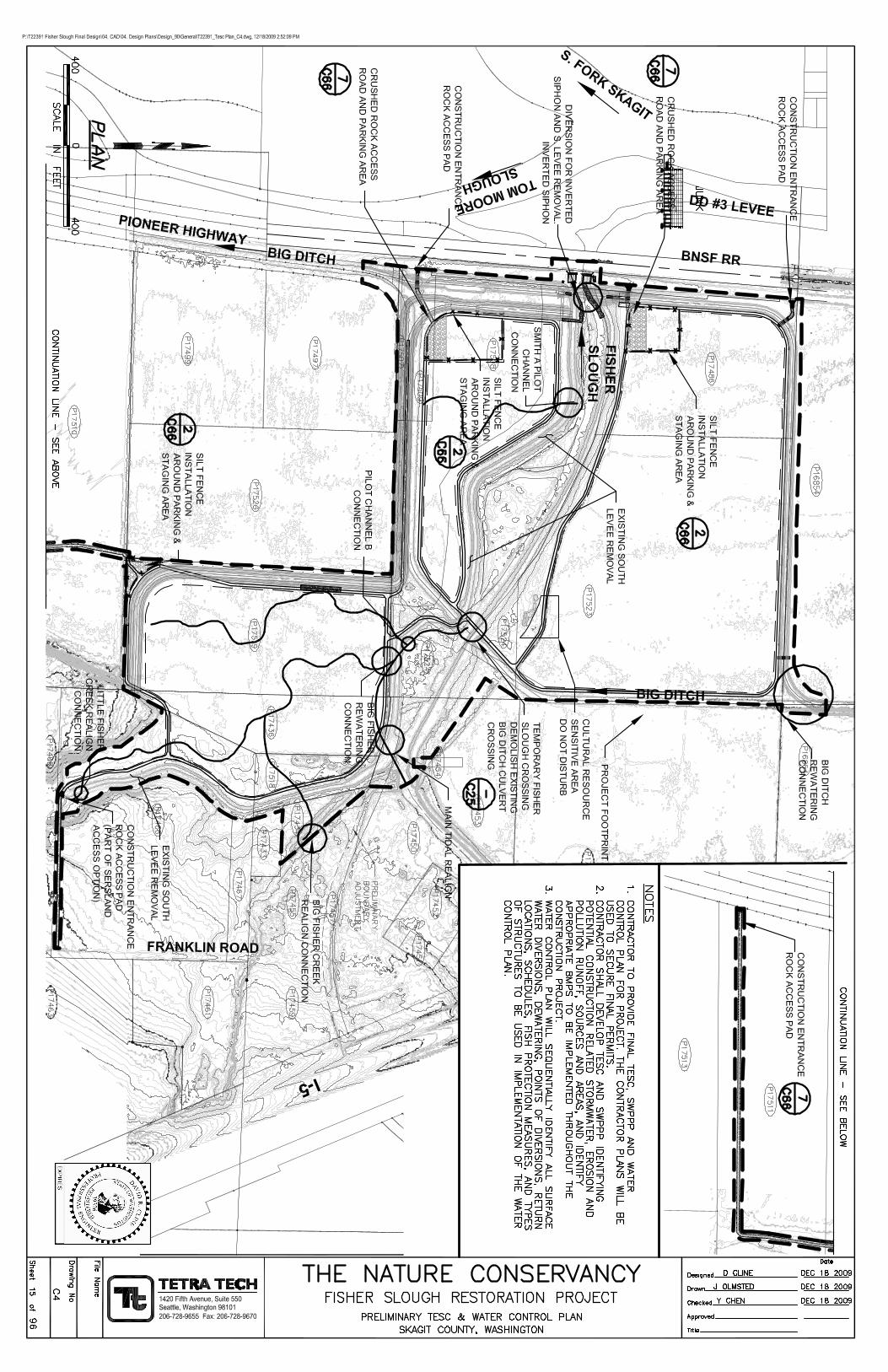
INTRODUCTION AND PROJECT OVERVIEW The Fisher Slough Restoration Project is a 60 acre tidal marsh restoration project located on the South Fork Skagit River Delta. The project has several components, including: restore historical tidal marsh vegetation communities and rearing areas for juvenile Chinook; remove fish passage barriers; provide watershed connectivity for coho, chum and other native fish species; and improve flood and sediment storage conditions for the tributary levee system. The project is a collaborative effort between The Nature Conservancy (TNC), Dike District #3 (DD#3), Drainage District #17 (DD#17), Skagit County, and a number of other government agencies, technical reviewers and local landowners. TNC has actively engaged the project partners using a proactive collaborative approach for making informed technical decisions regarding the project development, design, implementation, long term operations, maintenance and adaptive management strategies. The Fisher Slough project site is located just south of the town of Conway, WA, at the downstream end of the Carpenter Creek watershed, at the confluence with Tom Moore Slough on the South Fork of the Skagit River (Figure 1).
STORMWATER REGULATIONS The construction and restoration project is subject to a number of State of Washington regulations, namely the Water Quality Standards for Surface Waters of the State of Washington, Chapter 173-201A WAC, 2006. These regulations include a number of criteria that will need to be adhered to during construction. Through these regulations, the Washington State Department of Ecology will be issuing a 401 Water Quality permit as part of the federal 404 permit issuance as part of the JARPA process. The specific elements of the regulations that most apply to the project are related to turbidity. Turbidity is the most likely cause of potential water pollution and degradation of water quality as a result of construction activities. Regulatory standards require turbidity levels downstream from the construction site, at the point of compliance, to remain below 5NTUs over background turbidity if background is less than 50NTU, or a maximum of 10% increase if background is over 50NTU. The point of compliance for Fisher Slough will be 100ft downstream from the activity causing the turbidity. The most likely location for monitoring is downstream of the Fisher Slough floodgates, which has downstream access to the channel. In addition to the 401 water quality certification, the project site is roughly 155 acres in size, and exceeds the 1 acre threshold for construction stormwater general permits. Per the contract plans and specification, the construction contractor will be required to file and receive a Construction Stormwater General Permit from the Washington State Department of Ecology. The filing and receipt of the Construction Stormwater General Permit will eventually supersede this document. This Temporary Erosion and Sediment Control Plan (TESC) is being filed by the engineering consultant on behalf of The Nature Conservancy to fulfill the requirements of the Skagit County Grading Application. Also this submittal will outline the initial approach for construction stormwater management and appropriate BMPs and water management structures for the project. Ultimately, it will be the responsibility of the construction contractor to update the contents of this submittal as part of their Stormwater Management and Pollution Prevention Plan (SWPPP), per the requirements of the Construction Stormwater General Permit.
The Nature Conservancy DRAFT TESC Plan Fisher Slough – Final Design and Permitting
2 November 2009
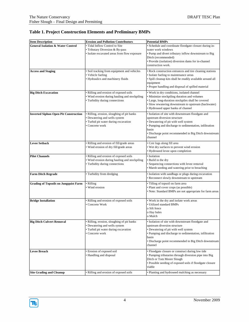
PROJECT ELEMENTS AND BMP APPROACH The restoration project has been designed in such a matter to consider and limit the environmental effects during construction. Much effort and detail has been invested in developing the construction sequence and methods to work towards this goal. One of the key approaches for the project are to build a number of the project features completely in the dry, and then connect channels, tributaries, and restored tidal marsh areas through a number of small breaches and rewatering activities. The second key element of the project is to utilize and close the downstream floodgate to limit the amount of tidal inflow, in combination with pumping by-pass of tributary inflows, to “isolate” the site using local farm drainage and flood control infrastructure. The approach in developing appropriate preliminary site BMPs was to identify the construction features, and evaluate the potential runoff, erosion, turbidity and pollution sources, pathways and mechanisms. Then, appropriate BMPs were identified that could provide adequate water quality protection (Table 1).
PROJECT SCHEDULE The project construction schedule is planned to occur from May 1 through Oct. 15th, 2010 and 2011. BMPs will meet the specified application requirements per Skagit County and Washington Department of Ecology, Western Washington Stormwater Design Manual, 2005.
SUPPORTING DOCUMENTS A number of supporting design plans and documents are available for this submittal. A site plan, grading plan, preliminary water control and diversion plan, and standard project BMPs are included in Attachment A, and are sheets contained within the overall project plan set, specifications and contract documents. Additional information regarding inverted siphon and the existing Big Ditch culvert removal, preliminary excavation pits, diversion and dewatering plans can be made available to Skagit County upon request. Contractor submittals regarding final SWPPP, construction, diversion and dewatering plans will be available from The Nature Conservancy and their contractor in March through April 2010 timeframe, and can be provided upon request.

The Nature Conservancy DRAFT TESC Plan Fisher Slough – Final Design and Permitting
3 November 2009
INSERT FIGURE 1. PROJECT VICINITY MAP
The Nature Conservancy DRAFT TESC Plan Fisher Slough – Final Design and Permitting
4 November 2009
Table 1. Project Construction Elements and Preliminary BMPs Item Description Erosion and Pollution Contributors Potential BMPsGeneral Isolation & Water Control • Tidal Inflow Control to Site
• Tributary Diversion & By-pass • Isolate excavated areas from flow exposure
• Schedule and coordinate floodgate closure during in-water work windows• Pump and divert tributary inflow downstream to Big Ditch (recommended) • Provide (isolation) diversion dams for in-channel construction work.
Access and Staging • Soil tracking from equipment and vehicles• Vehicle fueling• Hydraulics and machinery fluids
• Rock construction entrances and tire cleaning stations • Isolate fueling to maintenance areas• Spill cleanup kits shall be readily available around all equipment• Proper handling and disposal of spilled material
Big Ditch Excavation • Rilling and erosion of exposed soils• Wind erosion during hauling and stockpiling• Turbidity during connections
• Work in dry conditions, isolated channel• Minimize stockpiling duration and volumes• Large, long-duration stockpiles shall be covered • Slow rewatering downstream to upstream (backwater)• Hydroseed upper banks of channel
Inverted Siphon Open Pit Construction • Rilling, erosion, sloughing of pit banks• Dewatering and wells system• Turbid pit water during excavation• Concrete work
• Isolation of site with downstream floodgate and upstream diversion structure• Dewatering of pit with well system• Pumping and discharge to sedimentation, infiltration basin• Discharge point recommended in Big Ditch downstream channel
Levee Setback • Rilling and erosion of fill/grade areas• Wind erosion of dry fill/grade areas
• Coir logs along fill area• Wet dry surfaces to prevent wind erosion• Hydroseed levee upon completion
Pilot Channels • Rilling and erosion of exposed soils• Wind erosion during hauling and stockpiling• Turbidity during connections
• Isolation • Build in the dry• Sequencing connections with levee removal• Marsh seeding and watering prior to breaching
Farm Ditch Regrade • Turbidity from dredging • Isolation with sandbags or plugs during excavation• Reconnect slowly downstream to upstream
Grading of Topsoils on Jungquist Farm • Rilling • Wind erosion
• Tilling of topsoil on farm area• Plant and cover crops (as possible)• Note: Standard BMPs are not appropriate for farm areas
Bridge Installation • Rilling and erosion of exposed soils• Concrete Work
• Work in the dry and isolate work areas• Utilized standard BMPso Silt fenceo Hay baleso Mulch
Big Ditch Culvert Removal • Rilling, erosion, sloughing of pit banks• Dewatering and wells system• Turbid pit water during excavation• Concrete work
• Isolation of site with downstream floodgate and upstream diversion structure• Dewatering of pit with well system• Pumping and discharge to sedimentation, infiltration basin• Discharge point recommended in Big Ditch downstream channel
Levee Breach • Erosion of exposed soil• Handling and disposal
• Floodgate closure or construct during low tide• Pumping tributaries through diversion pipe into Big Ditch or Tom Moore Slough• Possible seeding of exposed soils if floodgate closure viable
Site Grading and Cleanup • Rilling and erosion of exposed soils • Planting and hydroseed mulching as necessary

The Nature Conservancy DRAFT TESC Plan Fisher Slough – Final Design and Permitting
5 November 2009
Attachment A – Supporting Design Plans