Embed Size (px)
Citation preview

http://www.urbem.net/
Urban River Basin Enhancement Methods
funded by
European Commission
5th Framework Programme, Key Action 4
“City of tomorrow and cultural heritage“
Test of the Draft Tool for Assessing Potential for
Rehabilitation Weisseritz Case Study, Workshop
A contribution for Work Package 5 and 6
08.07.2004
Leibnitz Institute of Ecological and Regional Development, Dresden (IOER)
Dipl.-Geograph Alfred Olfert
Tel.: ++ 49-351-4679-233
Fax: ++ 49-351-4679-212
Email: [email protected]
Web: http://www.ioer.de
Technische Universität Dresden
Faculty of Architecture, Institute for Landscape Architecture
Chair of Landscape Construction
Prof. J. T. Tourbier Dipl.-Ing. Ines Gersdorf
Tel.: ++ 49-351-4633-3453 ++ 49-351-4633-2346
Fax: ++ 49-351-4633-7081 ++ 49-351-4633-7081
Email: [email protected] [email protected]
Web: http://www.tu-dresden.de/urbem http://www.tu-dresden.de/urbem
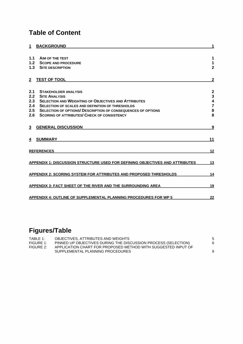
Table of Content
1 BACKGROUND 1
1.1 AIM OF THE TEST 1 1.2 SCOPE AND PROCEDURE 1 1.3 SITE DESCRIPTION 2
2 TEST OF TOOL 2
2.1 STAKEHOLDER ANALYSIS 2 2.2 SITE ANALYSIS 3 2.3 SELECTION AND WEIGHTING OF OBJECTIVES AND ATTRIBUTES 4 2.4 SELECTION OF SCALES AND DEFINITION OF THRESHOLDS 7 2.5 SELECTION OF OPTIONS/ DESCRIPTION OF CONSEQUENCES OF OPTIONS 8 2.6 SCORING OF ATTRIBUTES/ CHECK OF CONSISTENCY 8
3 GENERAL DISCUSSION 9
4 SUMMARY 11
REFERENCES 12
APPENDIX 1: DISCUSSION STRUCTURE USED FOR DEFINING OBJECTIVES AND ATTRIBUTES 13
APPENDIX 2: SCORING SYSTEM FOR ATTRIBUTES AND PROPOSED THRESHOLDS 14
APPENDIX 3: FACT SHEET OF THE RIVER AND THE SURROUNDING AREA 19
APPENDIX 4: OUTLINE OF SUPPLEMENTAL PLANNING PROCEDURES FOR WP 5 22
Figures/Table TABLE 1: OBJECTIVES, ATTRIBUTES AND WEIGHTS 5 FIGURE 1: PINNED UP OBJECTIVES DURING THE DISCUSSION PROCESS (SELECTION) 6 FIGURE 2: APPLICATION CHART FOR PROPOSED METHOD WITH SUGGESTED INPUT OF
SUPPLEMENTAL PLANNING PROCEDURES 9

IOER/TUD WP 5, Contribution to Deliverable 5.2 Test of the proposed Tool for the Assessment of Rehabilitation Potential
1
1 Background
1.1 Aim of the test As proposed by the URBEM proposal, the new tool to assess the potential for urban watercourse rehabilitation is to be tested on case study sites, chosen for WP 3. Deviating from this proposal, in agreement with HR Wallingford an alternative case study site was chosen. The site was found to be in the stage of assessing potential for rehabilitation options and therefore most suitable for the proposed test. Further reasons included:
overlapping ongoing planning: EU - Urban redevelopment program (EFRE and LUDA), district redevelopment program (Altplauen), Flood Control Concept Weisseritz (resulting from flood in August 2002) and therefore a very good information pool
diverse existing concepts (student projects, …) and interests of stakeholders, which create a “reality situation” for the testing of the tool
the “Tool to assess social appraisal”, another tool of the URBEM project, has been tested at the site, providing information on how the site and the river as well as some concepts are appraised by residents
The test of the tool is based on the draft tool description (HR Wallingford, 2003) delivered in February 2004. The test aims at analysing the practicability of the proposed concept. The test emphasises:
Plausibility of single steps Plausibility of the sequence of working steps Dynamic of procedure.
1.2 Scope and procedure The test of the tool took mainly place in the scope of a student workshop. It took three steps:
1. Throughout analysis of the tool and the proposed working steps
2. Application of the tool in a four-days-workshop with an international student group under simulation of a real stakeholder and decision making process
3. Careful analysis of tool and workshop results and questioning of students for their experience with and opinion on the tool
In a first step the structure of the draft tool was analysed. Steps of the tool were adapted for the proposed workshop and methods and tools needed for simulation were prepared. The project site - a section of the Weisseritz river in Dresden – was chosen due to existing development proposals. Planning is in the stage of defining rehabilitation alternatives. This stage seemed appropriate for assessing the potential for rehabilitation under reality conditions. The workshop was designed for an interdisciplinary student group1 with backgrounds in Landscape Architecture, Architecture and Water Resource Management. Students were provided with an extensive data compilation and a series of lectures by real stakeholders combined with a detailed onsite visit to become acquainted with the site. Through assigning students with stakeholder roles the tool was to be tested under consideration of real circumstances of the chosen case study. The workshop was preceded by a 10-days excursion of urban river rehabilitation sites in Switzerland and Germany.2 During the workshop students were guided through the assessment process proposed in the tool. In the workshop scenarios of possible rehabilitation schemes were produced by the students based on available information, taking into account existing options and knowledge of example solutions seen during the excursion. Two additional methods were integrated into the proposed tool to further structure the approach to create alternative schemes and assess their potential. This included
1Excursion and Workshop participation included students from the following institutions: Water Resources and Civil Engineering, University of Ljubliana, Slovenia; Landscape Architecture, University of Ljubliana, Slovenia; Architecture and Urban Design, Kent State University, USA; Landscape Architecture, University of Technology, Dresden, Germany. 2 URBEM Case Study sites visited were daylighted streams in Zurich; the restored River Isar in Munich; Pforzheim river rehabilitation, restored streams at IBA Emscherpark, as well as sites in Berlin.
IOER/TUD WP 5, Contribution to Deliverable 5.2 Test of the proposed Tool for the Assessment of Rehabilitation Potential
2
An adopted method of architectural programming to structure the definition of problems, qualities, opportunities and constraints and the selection process of objectives and attributes.
A Delphi Method based tool to reach a transparent agreement of weights by stakeholders. During and after the workshop students were asked for their experience with the tool and notes were taken during the process itself. Results, commentaries and suggestions are integrated into this report.
1.3 Site description The chosen testing site for the tool is located in Dresden, at the Weisseritz river between ‘Bienertmühle’ and ‘Freiberger Strasse’, in the neighbourhoods ‘Plauen’ and ‘Löbtau’. The Weißeritz river is the largest tributary of the Elbe river in the region and the second important river for Dresden. Flowing through an industrialised area the Weißeritz river is most affected by hard bed and bank lining, straitening, general (historic) channel relocation, fragmentation, water withdrawal, major runoff modification and historically also severe water pollution. Most of the river’s urban flood plain is densely used and there is almost no buffer zone for any modification of channel patterns. Water quality has considerably improved during the past thirteen years, though habitat degradation and runoff modification continues limiting ecological and aesthetic qualities of the river. However stabile population of grayling and occasionally trout indicate the outstanding biological potential of the river. Neighbourhood districts lack green public open space and are characterised by economic decline, industrial wastelands, high vacancies in housing and undersupply of cultural infrastructure. Due to this, numerous concepts have been developed to upgrade the area during the last decade. Hereby the river and its corridor have been a central feature. All plans have been set back after August 2002 when urban areas along the Weisseritz river where most severe hit by a flash flood. Now, new schemes have to cope with higher flood protection standards. Additionally, a major upgrading of a street next to the river is planned which has to be considered in the options. Also, in 2003 implementation of the District Redevelopment Plan “Integriertes Stadtteilentwicklungskonzept Weisseritz (Weisseritz)” has started.
2 Test of tool
2.1 Stakeholder analysis
Approach For neighbourhood districts at the Weisseritz a stakeholder analysis has been done as part of the District Redevelopment Plan Weisseritz. The City Planning Department of Dresden arranged diverse “stakeholder talks”, to identify their expectations, wishes and opinions and at the same time to gain support for the initiated project. Smaller projects should reflect possible long term changes within a short time period, to induce awareness and appraisal. Therefore stakeholders for the talks were chosen on base of possible outputs rather than having a systematic stakeholder analysis. The outputs were summarised and integrated into the framework plan (Stadtplanungsamt LH Dresden, 2003). Following stakeholders were identified for the whole area:
City administration – project group of diverse professions Neighbourhood council Agency responsible for redevelopment of adjacent area Plauen Proprietors in the Weisseritz corridor Citizen initiatives Diverse interest groups for economy and trade Scientific support – Institute for Regional and Ecological Development (IOER)
For the proposed green corridor along the Weisseritz following additional stakeholders were identified: Landestalsperrenverwaltung (State Water Management Agency) NaBu (Nature Protection NGO) DB Immobilien and Drewag (major proprietors) ADFC (German Bicycle Association)
IOER/TUD WP 5, Contribution to Deliverable 5.2 Test of the proposed Tool for the Assessment of Rehabilitation Potential
3
Implementation For the workshop and for reasons of practicability, the number of stakeholders was reduced to six, ensuring that different major objectives, opinions and interests were covered. Following, stakeholders were identified for the workshop, each to be represented by one workshop participant:
Planning Department of the City Administration Dresden Responsible for Framework Planning including river, city and social development Environmental Department of the City Administration Dresden / Environmental NGO Responsible for Environmental issues in the city, for development of flood protection scenarios. Mobility Department of the City Administration Dresden Developing and sustaining urban private and public transportations networks Saxony Water Management Agency (LTV) Responsible for flood alleviation schemes at first order rivers in the Free State of Saxony. Weisseritz is classified first order river. Proprietors/merchants Private interests for improvement of infrastructure and enhancement of site related soft factors Citizen and citizens initiatives Concerned about the neighbourhood qualities, including aesthetical and recreational values, cultural offers, playgrounds, green spaces and trees, accessibility, flood safety, historical values, participation
During the workshop introduction representatives from city and state authorities as well as from civic initiatives gave short presentations, describing their objectives and specific knowledge of the site. An extensive onsite visit with additional representatives widened insights into the topic.
Discussion of results Due to the existing stakeholder analysis and the familiarity with the site including its comprehensive planning background, identification of important stakeholder interests for the workshop was easy to accomplish and basically done trough professional judgement and discussion of whom to include.
2.2 Site Analysis
Approach The analysis of site information was to provide a basis for defining objectives and attributes. After introduction and site visit, qualities and constraints of the site and based on these definitions of objectives and attributes were defined. An adapted “architectural programming method” was used, to facilitate a transparent discussion process. “In the activity of programming [site specific] information is identified and documented in terms of functions, activities, and performance criteria the proposed [design] is to meet”. The method tries to comply with the need for an “effective communication among those, who design and those who use the built environment”. (Preiser, 1985, p 8). Programming can be done during a workshop with diverse stakeholders or through single discussions with each stakeholder. In both cases the end product is a matrix representing a program concepts that becomes a component of a river enhancement project (cf. Appendix 1). For the group approach during the programming a moderator uses paper cards to write down qualities and constraints and later on objectives and attributes. During the discussion those cards are pinned up. This provides for a continuous overview of the evolving process and gives stakeholders a possibility to participate, to intervene and comment and to identify common interest, qualities and opportunities as well as problems and constraints and in a later step objectives and attributes.
Implementation Workshop participants were the combination of water resources engineers, city planner/architects and landscape architects that are found to be the participants of urban river rehabilitation projects. Relevant data for the site analysis (cf. extract in Appendix 3: Fact sheet of the river and the surrounding area) was gathered from different existing planning proposals by workshop assistants and provided to the students. Short presentations of the stakeholders and a guided, detailed site visit
IOER/TUD WP 5, Contribution to Deliverable 5.2 Test of the proposed Tool for the Assessment of Rehabilitation Potential
4
supplied additional information and gave students the possibility to inquire details before taking stakeholder roles. In the subsequent discussion, with the help of paper cards, qualities and problems were pinned up, which delineated major themes for potential intervention (cf. matrix in Appendix 1: Discussion structure used for defining objectives and attributes). Physical constraints at the chosen sites were considered to include existing urban structures and plans for traffic relocation. This was included in the design of options. Physical constraints for ecological improvement exist onsite as well as up and downstream of the considered river section but have not been addressed.
Discussion The step of acknowledging problems and constraints, qualities and opportunities should be given appropriate weight at the very beginning of the site analysis process. This may effectively influence selection of a rehabilitation site as well as design options for site rehabilitation. It furthermore might contribute to a common understanding of views of participating stakeholders which is needed in the subsequent step of finding objectives and attributes. A clear definition of objectives is only possible with a good knowledge of a site’s qualities and constraints. For comprehensive rehabilitation projects approaches such as a complete SWOT analysis of the site and other assessment methods (e.g. various ecological analysis methods) may be useful. In any case the analysis of possible constraints for the rehabilitation options (incl. flood defence standards, long-term spatial limitations such as buildings, infrastructure or topography, existing strategic planning statements, irreversible migration barriers, unavoidable noise from close main traffic connections etc.) should be included. It seems appropriate for URBEM to provide guidance on how to engage in a planning process that meets the stakeholder involvement requirements of the Water Framework Directive. The currently proposed methodology for WP 5 states that the need for involvement of stakeholders should be recognised explicitly. More work is needed to define such a planning process and as proposed by URBEM and as outlined in the WP 5 draft tool (p. 13) advice on this theme should be included in the final methodology through input from other URBEM partners.3 The utilisation and application of the “Architectural Programming Method” during the site analysis process occurred in recognition of such a need. Appendix 4: Outline of Supplemental Planning Procedures for WP 5 displays an example on how the proposed WP 5 methodology can be embellished with other planning tools.
2.3 Selection and Weighting of Objectives and Attributes Approach The adapted programming method (see 2.2) was used, to design a transparent and active objective finding process. After objectives and attributes were agreed weights were assigned by stakeholders using the Delphi method. The tool here is used to obtain most coordinated average weights for objectives and attributes and to promote an effective and transparent means of decision (or compromise) finding of involved stakeholders.
The Delphi method may be characterised as a method for structuring a group communication process so that the process is effective in allowing a group of individuals, as a whole, to deal with a complex problem (Linestone & Turoff 2002). The original objective was to "obtain the most reliable consensus of opinion of a group of experts ... by a series of intensive questionnaires interspersed with controlled opinion feedback" (Dalkey & Helmer 1963).
A “major advantage of the Delphi method is that it avoids problems commonly encountered in face-to-face groups meetings. These problems include the influence of key persons on the responses of other panel members as well as the geographical constraints and costs of bringing together a group of experts. The anonymity of answers allows Delphi participants to express their personal views freely.” (Greiving et al. 2004)
Implementation Based on received information objectives and attributes were determined by the test groups. For this purpose a discussion has collated qualities and problems of the project area and has delineated major concepts for potential intervention (cf. Appendix 1: Discussion structure used for defining objectives and attributes). Ideas received have then been condensed to objectives and attributes and discussed
3 One example for a stakeholder identification and involvement is the „Tidal Schuylkill Master Plan”, a case study distributed by the TU Dresden for the URBEM Work Package 7.
IOER/TUD WP 5, Contribution to Deliverable 5.2 Test of the proposed Tool for the Assessment of Rehabilitation Potential
5
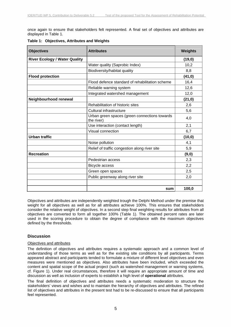
once again to ensure that stakeholders felt represented. A final set of objectives and attributes are displayed in Table 1.
Table 1: Objectives, Attributes and Weights
Objectives Attributes Weights
River Ecology / Water Quality (19,0) Water quality (Saprobic Index) 10,2 Biodiversity/habitat quality 8,8 Flood protection (41,0) Flood defence standard of rehabilitation scheme 16,4 Reliable warning system 12,6 Integrated watershed management 12,0 Neighbourhood renewal (21,0) Rehabilitation of historic sites 2,6 Cultural infrastructure 5,6
Urban green spaces (green connections towards the river) 4,0
Use interaction (contact length) 2,1 Visual connection 6,7 Urban traffic (10,0) Noise pollution 4,1 Relief of traffic congestion along river site 5,9 Recreation (9,0) Pedestrian access 2,3 Bicycle access 2,2 Green open spaces 2,5 Public greenway along river site 2,0 sum 100,0
Objectives and attributes are independently weighted trough the Delphi Method under the premise that weight for all objectives as well as for all attributes achieve 100%. This ensures that stakeholders consider the relative weight of objectives. In a second step final weighting results for attributes from all objectives are converted to form all together 100% (Table 1). The obtained percent rates are later used in the scoring procedure to obtain the degree of compliance with the maximum objectives defined by the thresholds.
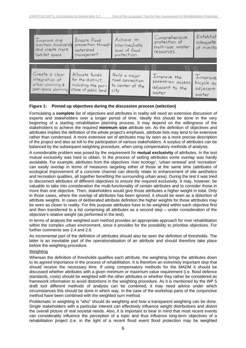
Discussion Objectives and attributes The definition of objectives and attributes requires a systematic approach and a common level of understanding of those terms as well as for the existing site conditions by all participants. Terms appeared abstract and participants tended to formulate a mixture of different level objectives and even measures were mentioned as objectives. Also attributes have been included, which exceeded the content and spatial scope of the actual project (such as watershed management or warning systems, cf. Figure 1). Under real circumstances, therefore it will require an appropriate amount of time and discussion as well as inclusion of experts to establish a high level of operational attributes. The final definition of objectives and attributes needs a systematic moderation to structure the stakeholders’ views and wishes and to maintain the hierarchy of objectives and attributes. The refined list of objectives and attributes in the present test had to be re-discussed to ensure that all participants feel represented.
IOER/TUD WP 5, Contribution to Deliverable 5.2 Test of the proposed Tool for the Assessment of Rehabilitation Potential
6
Figure 1: Pinned up objectives during the discussion process (selection)
Formulating a complete list of objectives and attributes in reality will need an extensive discussion of experts and stakeholders over a longer period of time. Ideally this should be done in the very beginning of a starting rehabilitation planning process. It may depend on the willingness of the stakeholders to achieve the required minimum size attribute set. As the definition of objectives and attributes implies the definition of the whole project’s emphasis, attribute lists may tend to be extensive rather than condensed. A more extensive set of attributes may by seen as a more precise description of the project and also as toll to the participation of various stakeholders. A surplus of attributes can be balanced by the subsequent weighting procedure, when using compensatory methods of analysis. A considerable problem was posed by the requirement for mutual exclusivity of attributes. In the test mutual exclusivity was hard to obtain. In the process of setting attributes some overlap was hardly avoidable. For example, attributes from the objectives ‘river ecology’, ‘urban renewal’ and ‘recreation’ can easily overlap in terms of measures targeting either of those at the same time (attributes of ecological improvement of a concrete channel can directly relate to enhancement of site aesthetics and recreation qualities, all together benefiting the surrounding urban area). During the test it was tried to disconnect attributes of different objectives to ensure the required exclusivity. It may, however, be valuable to take into consideration the multi-functionality of certain attributes and to consider those in more than one objective. Then, stakeholders would give those attributes a higher weight in total. Only in those cases, where the overlap of attributes has been ignored, it should be seen as a distortion of attribute weights. In cases of deliberated attribute definition the higher weights for those attributes may be seen as closer to reality. For this purpose attributes have to be weighted within each objective first and then transferred to a list comprising all attributes as a second step – under consideration of the objective’s relative weight (as performed in the test). In terms of analysis the weighted sum method provides an appropriate approach for river rehabilitation within the complex urban environment, since it provides for the possibility to prioritise objectives. For further comments see 2.4 and 2.6. As incremental part of the definition of attributes should also be seen the definition of thresholds. The latter is an inevitable part of the operationalisation of an attribute and should therefore take place before the weighting procedure. Weighting Whereas the definition of thresholds qualifies each attribute, the weighting brings the attributes down to its agreed importance in the process of rehabilitation. It is therefore an extremely important step that should receive the necessary time. If using compensatory methods for the MADM it should be discussed whether attributes with a given minimum or maximum value requirement (i.e. flood defence standards, costs) should be weighted with the other attributes or whether they rather be considered as framework information to avoid distortions in the weighting procedure. As it is mentioned by the WP 5 draft tool different methods of analysis can be combined, it may need advice under which circumstances this should be done in which way. In the case of the workshop parts of the conjunctive method have been combined with the weighted sum method. Problematic in weighting is “who” should do weighting and how a transparent weighting can be done. Single stakeholders with a particular interest can effectively influence weight distributions and distort the overall picture of real societal needs. Also, it is important to bear in mind that most recent events can considerably influence the perception of a topic and thus influence long-term objectives of a rehabilitation project (i.e. in the light of a recent flood event flood protection may be weighted
IOER/TUD WP 5, Contribution to Deliverable 5.2 Test of the proposed Tool for the Assessment of Rehabilitation Potential
7
extremely high keeping many others as important societal demands/attributes far behind). In such cases it may be advisable to define minimum respectively maximum requirements for this attribute (i.e. minimum flood defence standard) and to take the attribute out from the overall assembly. Furthermore, to enable a “proper” weighting of attributes the proposed scales should be not only available but also comprehensible for all participants.
2.4 Selection of scales and definition of thresholds
Approach The Weighted Sum Method was chosen for the test. For some attributes minimal values (performance requirements) were determined reflecting the real situation (e.g. return frequency for flood defence standard or the saprobic index for water quality). Lacking feasibility, cost considerations were excluded from the test.
Implementation Where possible existing and approved measurements or indicators were used, while for others new scales were proposed. Based on the individuality of features of the rehabilitation site it was an issue to find suiting indicators for the attributes that would reflect best the individual situation. However, indicators as well as thresholds (see Appendix 3) remain tentative, illustrating the complexity on the attempt of making an attribute measurable.
Discussion The process of establishing thresholds for attributes (resp. for indicators and criteria measured for an attribute) turned out to be welcome to re-think the attributes chosen. In this step some attributes were called into question and at latest here the meaning of attributes became apparent to all participants. Therefore, definition of thresholds should be incorporated into the setting of attributes, since by defining the evaluation scale attributes become tangible. In the Weisseritz case study some of the attributes turned out to exceed the level of the rehabilitation project, making them immeasurable and thus distorting the weighted assembly of attributes. Only in this step some attributes were found to be not mutually exclusive but overlapping. Due to the fact that attributes and their indicators/criteria often touch specific aspects it is evident that this step can not be done without expert advice. This is especially true for invisible and not directly experienceable attributes such as ecological improvement or flood defence standards. Furthermore, based on the individuality of each urban area and river, chosen attributes will reflect very special issues that will need individual assessment by experts. Only few of those will be easily supplied, such as data for water quality. A by far larger problem is posed by the ex ante evaluation of rehabilitation effects at the attributes itself. It is highly improbable that attributes in reality can always be described by structural means that can be determined in advance (i.e. sinuosity). It is therefore likely that the prognosis of effects will often remain speculative. Only a part of attributes will allow modelling (e.g. flood related measures) to predict effects. This, however, requires appropriate resource availability (but is possible if feasible as shown by the example of modelling in the case of the Skerne River in Darlington by HR Wallingford). Especially with regard to not quantifiable respectively not objectively measurable issues such as e.g. aesthetics or geomorphology, ways need to be found to assess the effects of options beforehand. Social issues again, may need a purposeful investigation of individual parameters as statistical data may not reflect spatial or thematic topics of the rehabilitation scheme resp. resolution of existing data may not always respond to the spatial scale requirements of the project. Against this background it seems appropriate to seek expert advice in rehabilitation projects. Important in this context is also the temporal scale in which the planned effect can be expected (flood defence standard relaying on local structural measures may be achievable on the end of construction works; aesthetic enhancement or improved biodiversity may need years to fully develop as vegetation grows and habitats reshape with time). Furthermore, practicable scales are necessary for individual attributes. A mixture of absolute value scales and relative (descriptive) scales may be appropriate. However, due to the above mentioned problems and for efficiency, certainty and practicability reasons, established attributes and connected scales/measures should be used of wherever possible.

IOER/TUD WP 5, Contribution to Deliverable 5.2 Test of the proposed Tool for the Assessment of Rehabilitation Potential
8
2.5 Selection of options/ Description of consequences of options
Approach The students task was to develop different options for the river and the river corridor under consideration of existing options for the Weisseritz and in light of example solutions seen at the excursion. Two groups were given different premises for a major road development, which spatially and functionally would influence the design of the river and its vicinity. Known physical constraints and agreed objectives were to be taken into account. The description of consequences of options was integrated into the development of options, due to the conceptual character of planning.
Implementation During two days the two groups developed three options. These options considered physical constraints and objectives at a conceptual level. A major physical constraints for future enhancement was posed by the planned major road and buildings adjacent to the river. Costs were not considered (see 2.5). The task was not only to include the enhancement of the river but also of the river corridor and its connection to the neighbourhood districts. The three emerging options did not vary much in terms of ecological enhancement for the river, but had different social (mostly recreational) implications. During the development of options, consequences were discussed, which then gave feedback to further development of options. A description of consequences of single measures or measure or groups of measures was not prepared.
Discussion Predetermined site selection and existing constraints limited options for design, whereas in consequence developed options seemed to be very similar at this conceptual stage, but were varying in detail. Since costs were not taken into account, freedom existed in the selection of measures. With a consideration of costs a greater variation and emphasis on different aspects may have been developed. Due to missing feasibility at this stage, it was felt not to be appropriate and not to be contributing to the testing of the tool itself.
2.6 Scoring of attributes/ Check of consistency
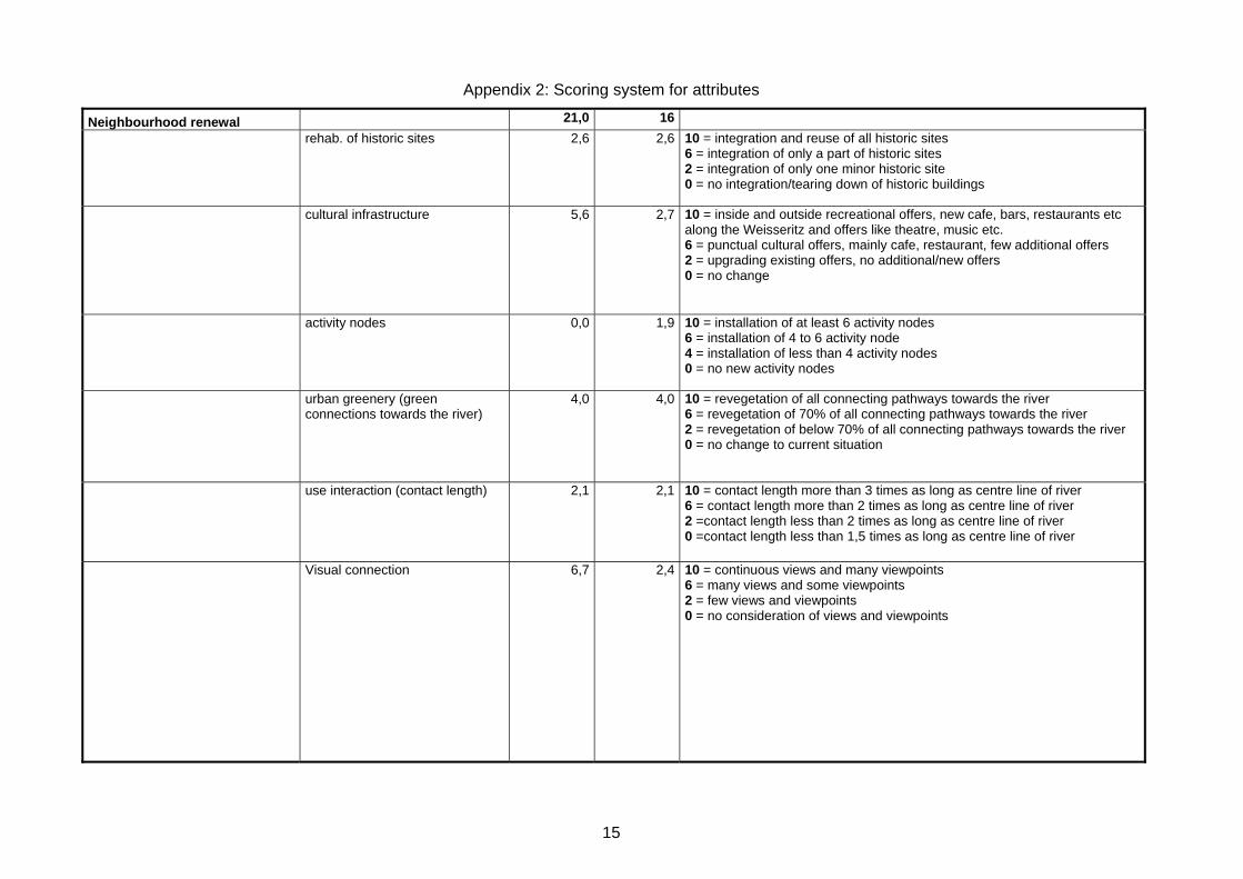
Approach Provided scales for attributes were used to conduct the ex ante assessment of different options based on their attributes. The scales for each attribute itself used ratings from 1 (lowest) to 10 (highest/best). Between three to four thresholds per attribute were provided with a description (cf. Appendix 2: Scoring system for attributes and proposed thresholds). Ratings in between those scores were acceptable.
Implementation The options were evaluated by each of the design groups themselves. The scoring tool was constructed to reflect a “compliance degree” of each option measured against the maximum achievable 100% (100% = maximum possible score defined by the thresholds). Two proposed options were scored with about 45%, one option was scored with 60%.
Discussion Under the conceptual level of the design, the fulfilment of performance requirements could not be judged accurately, also due to missing expertise. On basis of the scoring through the designers of the options, the degree of subjectivity was very high, and the results can not be considered to display a realistic preference for one of the options. Therefore, scoring of attributes related to the diverse options should be done by a neutral committee and under expert consultancy. Nevertheless, the scoring procedure showed that an ex ante evaluation, of design impacts on attributes, especially without modelling, is hard to do. Some of the used indicators posed considerable problems for the participants – due to the discrepancy between the level of detail in the design options and the detail required to score the attributes, but also due to lacking expertise. The process of scoring options may be provided with a verbal-argumentative documentation for the options impacts to increase transparency.
IOER/TUD WP 5, Contribution to Deliverable 5.2 Test of the proposed Tool for the Assessment of Rehabilitation Potential
9
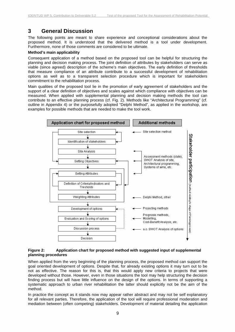
3 General Discussion The following points are meant to share experience and conceptional considerations about the proposed method. It is understood that the delivered method is a tool under development. Furthermore, none of those comments are considered to be ultimate. Method’s main applicability Consequent application of a method based on the proposed tool can be helpful for structuring the planning and decision making process. The joint definition of attributes by stakeholders can serve as viable (since agreed) description of the scheme’s main objectives. The early definition of thresholds that measure compliance of an attribute contribute to a successful development of rehabilitation options as well as to a transparent selection procedure which is important for stakeholders commitment to the rehabilitation process. Main qualities of the proposed tool lie in the promotion of early agreement of stakeholders and the support of a clear definition of objectives and scales against which compliance with objectives can be measured. When applied with supplemental planning and decision making methods the tool can contribute to an effective planning process (cf. Fig. 2). Methods like “Architectural Programming” (cf. outline in Appendix 4) or the purposefully adopted “Delphi Method”, as applied in the workshop, are examples for possible methods that are needed to make the tool work.
Figure 2: Application chart for proposed method with suggested input of supplemental planning procedures
When applied from the very beginning of the planning process, the proposed method can support the goal oriented development of options. Despite that, for already existing options it may turn out to be not as effective. The reason for this is, that this would apply new criteria to projects that were developed without those. However, even in those situations the tool may help structuring the decision finding process but will have little influence on the design of the options. In terms of supporting a systematic approach to urban river rehabilitation the latter should explicitly not be the aim of the method. In practice the concept as it stands now may appear rather abstract and may not be self explanatory for all relevant parties. Therefore, the application of the tool will require professional moderation and mediation between (often competing) stakeholders. Development of material detailing the application
IOER/TUD WP 5, Contribution to Deliverable 5.2 Test of the proposed Tool for the Assessment of Rehabilitation Potential
10
of the method will be useful. Furthermore, one or two detailed application reports from real projects could significantly contribute to the understanding of how the tool works and what can be expected from it. Approach to potential assessment In the urban context two complementary approaches to assess the potential for river rehabilitation seem appropriate. One is the site selection approach addressing site selection on a “over-site level” (basin, city, program etc. level). Here the purpose is a systematic selection of appropriate river sections or waters with the highest potential for rehabilitation. The second one is the design selection approach. In this case different options (designs) of rehabilitation for a chosen site are assessed. The first approach can also be seen as first step, important to ensure cost effectiveness, transparency and best compliance with the overall development perspectives of urban areas or objectives of a program. The second approach/step is needed to select the design addressing best the individually defined objectives. As proposed in February 2004 the method targets the design selection approach. This was tested reporting the workshop. It seems plausible that the methodical approach to site selection can also be based on the proposed objective/attribute concept. However, the proposed method needs specification for its utilisation for site selection.4 Target scale of the method The whole selection and assessment process as so far proposed addresses only short term resp. one step rehabilitation projects. Urban development, especially when taking place in constraint situation often contains middle and long-term strategic intensions, too. This implies that certain measures can be intended, but can only be implemented in a future intervention period, as constraints are overcome middle or long term. At this point it can not be stated how the method may work with such complex middle-term or long-term projects. Looking at the spatial extension of a project, subsections of complex projects may vary in their objectives and attributes. It can be anticipated that the proposed method would have to be repeated for each of the subsections. Limitation of the matrix based assessment method The proposed method is based on a matrix evaluation of different options. Thus, it considers the ability of each attribute to be classified according to individually determined thresholds and based on agreed methodologies. This can work as an important decision support instrument. However, it should, be borne in mind that a “simple” assignment of attributes to certain classes based on a often tentative ex ante evaluation can only be a more or less rough indicator for an option’s liability to really comply with proposed goals. Though, there may be cases, where options are so different that only little doubts are apposite. However, it should be considered, that classification of attributes can easily be wrong by one or several classes, that weights can change or that positive and adverse synergies have not been considered. Last but not least, a simple ‘sympathy factor’ for one option may be already overwhelming. For these and other reasons final decision can only take into account the result of the assessment. Though, the more transparent the process has been conducted, the closer the results of the applied method will be to the final decision. Ambition of the method The ambitions of the proposed method should be measured against the effort proposed for the evaluation. On one hand the draft tool description speaks of elaborate target definitions by objectives, attributes and scales, integration of experts, ex ante evaluation by numerical modelling, supply of studies etc.). On the other hand the method seems mainly to address short termed or single step interventions (see commentary above). This possibly bears a discrepancy between the expected or needed effort and a possibly low (spatial, temporal, financial, political) scale of the rehabilitation project. It may be useful to assess the method’s target scale for projects to ensure its ideal setting.
4 As emphasised in WP2 methods for appropriate site selection are of highest importance for systematic river rehabilitation. It can be expected that site selection methods are most urgently needed for systematic urban river rehabilitation, since those were not considered in most case studies areas

IOER/TUD WP 5, Contribution to Deliverable 5.2 Test of the proposed Tool for the Assessment of Rehabilitation Potential
11
4 Summary The draft tool received in February 2004 combines the assessment of rehabilitation potential (WP 5) with a decision support methodology (WP 9). The proposed tool is seen as outline to structure a complete planning process for a river section and therefore can provide for an increase in efficiency and transparency within a river rehabilitation project. The draft tool was tested in a student workshop. It was used for the selection of design options on a pre-determined river section, which also in reality, is target of an enhancement effort. For this approach the MADM “Weighted sum method” was chosen. Through the workshop experience several conclusions for the applicability, limitations, and effectiveness of the proposed tool for the case of a design selection could be made. Further advice on which method to use under which circumstance will help to increase efficiency and understanding of the tool and reduce the risk of choosing an inappropriate MADM method. It might be interesting to test the tool for a real project to test its acceptance by stakeholders with real constraints in time and possibly with limited preparedness for agreement. In reflection of the WP 2 results as well as the WP 5 description, testing of the method’s applicability for a site selection should be conducted.

IOER/TUD WP 5, Contribution to Deliverable 5.2 Test of the proposed Tool for the Assessment of Rehabilitation Potential
12
References Stefan Greiving, Mark Fleischhauer, Alfred Olfert: The Delphi method as a solution to the weighting problem in multi hazard cases: The case study of the Dresden region. Journal of Risk research (submitted in Mai 2004). Linstone, H.A., Turoff, M (2002). Introduction. In:. Linstone, H.A., Turoff, M (eds.) (2002). The Delphi Method. Techniques and Applications pp 3-19 N. Dalkey and O. Helmer. (1963) An Experimental Application of the Delphi Method to the Use of Experts. Management Science 9, No. 3 (April 1963), p. 458. Stadtplanungsamt LH Dresden (2002): Integriertes Stadtteilentwicklungskonzept Weisseritz - Feinkonzept. Dresden, April 2002 Stowasser A., Jakob, T. (2003): Entwicklungskonzepte im urbanen Raum nach einem Hochwasser am Beispiel der Weisseritz. In: Wasserbauliche Mitteilungen (Heft 24). Gewässer in der Stadt – Wasserbaukolloquium am 20./21.3.2003. IWD. Fakultät Bauingenieurwesen. TU-Dresden. Dresden, March 2003 Preiser, Wolfgang (1985): Programming the Built Environment. New York, 1985

Appendix 1: Discussion structure used for defining objectives and attributes
13
Appendix 1: Discussion structure used for defining objectives and attributes
Site Characteristics Objectives Values
Qualities Constrains Performance requirements Sub-objective (attributes) weights
Potential Interest conflicts
River Water Quality Hydrology Morphology Biology/Habitat
City Residential
Industrial/Commerce/Retail
Open spaces
Infrastructure/Access
Cultural heritage
Pollution
People Social
Safety
Aesthetics
Participation
Σ = 1

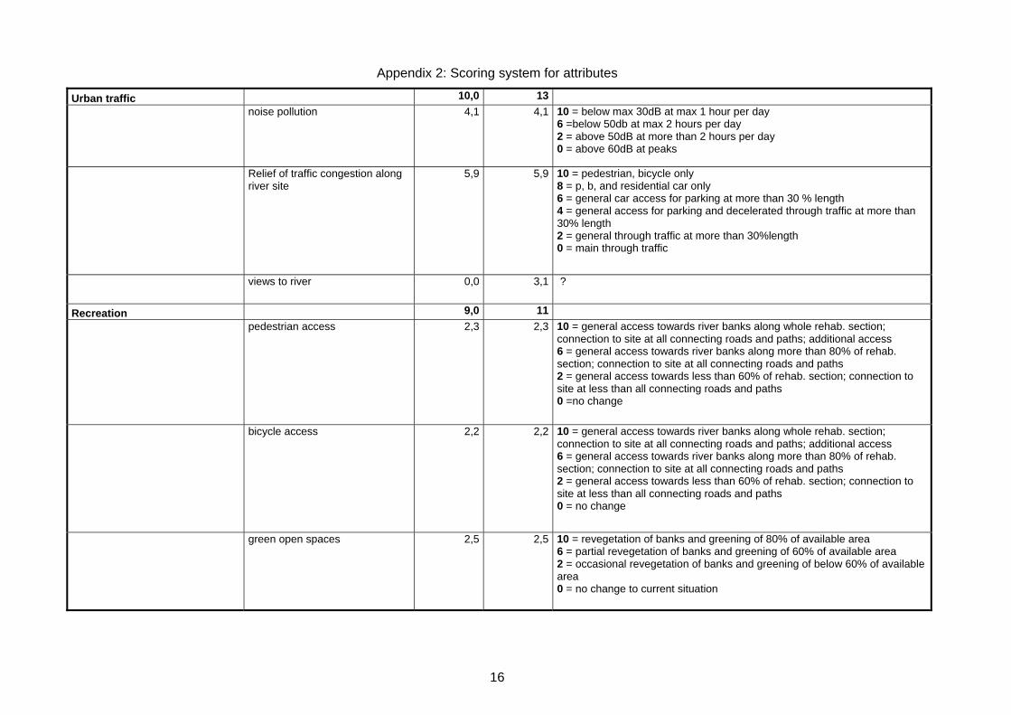
Appendix 2: Scoring system for attributes
14
Appendix 2: Scoring system for attributes and proposed thresholds
Objectives Attributes new weights
weights classification
River Ecology / Water Quality 19,0 19
water quality (saprobic index) 10,2 10,2 10 = I-II; 8 = II; 0 = below II = unacceptable
biodiversity/habitat quality 8,8 8,8 10 = restoration of all potentially natural fish species in self sustaining populations; incl. atlantic salmon spawning 8 = restoration of 90% of pot. natural fish species incl. brown trout spawning 6 = restoring up to 80% of pot. natural fish species, incl. ash spawning and elevation of trout; 4 =abundance of 60% of pot. natural fish species incl. ash and trout with diverse age structure 2 = occasional abundance of up to 60% of pot. natural fish species with limited age variation 0 = no change to situation before
Flood protection 41,0 41
flood control standard of rehab. scheme
16,4 16,4 10 = 100 Years; 8 = 200 Years; 0 = below 200 years unacceptable
reliable warning system 12,6 12,6 10 = 48 hours; 6 = 24 hours; 4 = 12 hours; 0 = less than 12 hours
integrated watershed management
12,0 12,0 10=coordination of stakeholders from more than 90% of land use including all critical points; Budget of more than 10 € per inhabitant 6=coordination of stakeholders from more than 75% of land use missing some critical points; Budget of more than 5 € per inhabitant 2=coordination of stakeholders from more than 60% of land use missing some critical points; Budget below 5 € per inhabitant 0 =no watershed management
Appendix 2: Scoring system for attributes
15
Neighbourhood renewal 21,0 16
rehab. of historic sites 2,6 2,6 10 = integration and reuse of all historic sites 6 = integration of only a part of historic sites 2 = integration of only one minor historic site 0 = no integration/tearing down of historic buildings
cultural infrastructure 5,6 2,7 10 = inside and outside recreational offers, new cafe, bars, restaurants etc along the Weisseritz and offers like theatre, music etc. 6 = punctual cultural offers, mainly cafe, restaurant, few additional offers 2 = upgrading existing offers, no additional/new offers 0 = no change
activity nodes 0,0 1,9 10 = installation of at least 6 activity nodes 6 = installation of 4 to 6 activity node 4 = installation of less than 4 activity nodes 0 = no new activity nodes
urban greenery (green connections towards the river)
4,0 4,0 10 = revegetation of all connecting pathways towards the river 6 = revegetation of 70% of all connecting pathways towards the river 2 = revegetation of below 70% of all connecting pathways towards the river 0 = no change to current situation
use interaction (contact length) 2,1 2,1 10 = contact length more than 3 times as long as centre line of river 6 = contact length more than 2 times as long as centre line of river 2 =contact length less than 2 times as long as centre line of river 0 =contact length less than 1,5 times as long as centre line of river
Visual connection 6,7 2,4 10 = continuous views and many viewpoints 6 = many views and some viewpoints 2 = few views and viewpoints 0 = no consideration of views and viewpoints
Appendix 2: Scoring system for attributes
16
Urban traffic 10,0 13
noise pollution 4,1 4,1 10 = below max 30dB at max 1 hour per day 6 =below 50db at max 2 hours per day 2 = above 50dB at more than 2 hours per day 0 = above 60dB at peaks
Relief of traffic congestion along river site
5,9 5,9 10 = pedestrian, bicycle only 8 = p, b, and residential car only 6 = general car access for parking at more than 30 % length 4 = general access for parking and decelerated through traffic at more than 30% length 2 = general through traffic at more than 30%length 0 = main through traffic
views to river 0,0 3,1 ?
Recreation 9,0 11
pedestrian access 2,3 2,3 10 = general access towards river banks along whole rehab. section; connection to site at all connecting roads and paths; additional access 6 = general access towards river banks along more than 80% of rehab. section; connection to site at all connecting roads and paths 2 = general access towards less than 60% of rehab. section; connection to site at less than all connecting roads and paths 0 =no change
bicycle access 2,2 2,2 10 = general access towards river banks along whole rehab. section; connection to site at all connecting roads and paths; additional access 6 = general access towards river banks along more than 80% of rehab. section; connection to site at all connecting roads and paths 2 = general access towards less than 60% of rehab. section; connection to site at less than all connecting roads and paths 0 = no change
green open spaces 2,5 2,5 10 = revegetation of banks and greening of 80% of available area 6 = partial revegetation of banks and greening of 60% of available area 2 = occasional revegetation of banks and greening of below 60% of available area 0 = no change to current situation

Appendix 2: Scoring system for attributes
17
public greenway 2,0 2,0 10 = creation of continuous greenway 8 = greenway once for less than 10% of section length disrupted 6 = greenway twice for in total less than 20% of section length disrupted 4 = greenway three times for less than 25% of section length disrupted 2 = greenway more than three times ore for more than 25% of section length disrupted 0 = no change
activity nodes (leisure time) 0,0 0,9 10 = installation of a variety of gastronomic and other leisure time facilities as activity nodes 6 = installation of only some leisure time facilities 2 = installation of only one or two facility 0 = no new activity nodes
views from river to residential 0,0 1,2 ?


Appendix 3: Fact sheet of the river and the surrounding area
19
Appendix 3: Fact sheet of the river and the surrounding area Sources: River/Site name:
Stadtplanungsamt LH Dresden (2002) Stowasser A., Jakob, T. (2003) Weisseritz/ Plauen/Löbtau (urban)
Catchment area: 366 km2, mainly in Low Mountain Range (Osterzgebirge)
River length: about 50 km
Change in altitude:
ca. 570 meter
River Characteristic:
low mountain range river with a high load of gravel high hydromorphologic dynamics tendency of sedimentation and relocation upstream of site: four large dams (Malter, Lehnmühle,
Klingenberg und Altenberg), weirs (Hegereitbrücke) and drops downstream: drops and weirs, riverbed is relocated from
‘Freiberger Strasse’ to mouth (Elbe) River zone: greyling zone spawning area for many fish species including
Atlantic Salmon (missing in the current species arrangement) Water quality:
Saprobic index: II (good - mesosaprob)
Water temperature:
3°Celsius winter, 15-18°Celsius summer
Hydrology Precipitation: mean annual precipitation: 750 mm (Freital, right upstream of site)
Medium Discharges:
mean discharge 3,42 m3/s mean withdrawal: about 1 m3/s
Flood discharges:
HQ 2 = 20 m3/s HQ 10 = 54 m3/s HQ 50 = 115 m3/s HQ 100 = 130 m3/s (Stand 2000) (Pegel Dölzschen) HQ 500 = 215 m3/s (Stand 2000) Flood August 2001:
300 mm precipitation in 24 hours – highest ever measured in Germany, run off coefficient of 80-90 %
Debris and flotsam relocated the riverbed, resulting in an uncontrolled retention/afflux of water 250 Million Euro damage
3rd time during a flood, that Weisseritz relocated itself into its old bed flooding the inner city of Dresden
Max discharge of flood ca. 430 m3/s
Design discharge:
Staatliche Umweltfachamt Radebeul: 260 m3/s proposed by City Council Dresden: 490 m3/s existing discharge capacity
in Plauen und Löbtau (min) ca. 130 m3/s
Morphology
Riverbed: hard constructions with couble stones and concrete historical bed from ‘Bienertmühle’ to ‘Freiberger Strasse’,
downstream bed is relocated (since 19th century) trapezoidal profile

Appendix 3: Fact sheet of the river and the surrounding area
20
Riverbanks: banks with stone and concrete walls, 3,50 and more meters high walls partially stabilising adjacent buildings
Biology
Fauna reduced diversity and abundance, limited reproduction. Considerable population of greyling Considerable population (not reproducing) of trout
Flora No instream vegetation, if arises, removed by maintanance at industrial wasteland urban ruderal vegetation potential natural vegetation: alluvial/riparian woodlands along ‘Hofmühlenstrasse’ and ‘Agnes-Smedley-Strasse’ street
trees: Tilia Spec.
Site boundaries Weisseritz from ‚Bienertmühle’ to ‚Freiberger Strasse’ and adjacent properties
Residential residential area of Wilhelminian style (most buildings before 1890), redevelopment needed
High percentage of vacancies Urban Redevelopment districts rents are not cheaper than in other (higher quality)
neighbourhoods
Industry/Commerce/Retail
above city average of industrial wasteland adjacent to the river in a devastated condition
investment in Weisseritz area is below city average retail is at risk through dwindling numbers of residents enhancement of site related soft factors
Open spaces only few green open spaces, playgrounds, meeting points,
cultural facilities River Weisseritz not accessible connection to ‘Plauenscher Grund’ at ‘Bienertmühle’
Infrastructure/ Accessibility
street network is in bad condition infrastructure band (street, train, railway) disconnects the area
from the inner-city main traffic via ‘Tharandter Strasse’ and ‘Nossener Bruecke’ low traffic ‘Fabrikstrasse’, moderate traffic ‘Hofmuehlenstrasse’ no special bike or pathways no people on the streets good accessibility with public transportation near ‘Bienertmühle’ Railway station to Mainstation no accessibility of river … …
Cultural heritage and Culture
concentration of industrial monuments (‘’Bienertmühle), … a. Historical village core ‘Alt Plauen’ b. Bienertmühle (old mill) c. Old butcher company from the 30ies with oldest underground
car park of Germany low number of restaurants, bars Youth house at Railway station

Appendix 3: Fact sheet of the river and the surrounding area
21
Theatre TIF Pollution Noise pollution through main traffic axis as well as industry
one of the most overheated areas in Dresden many industrial contaminated sites
Social fraction of people aged 0-5 and 18-44 very big compared to city age distribution in the EFRE Weisseritz area:
14% 17%
38%
14% 18%
0%
20%
40%
60%
80%
100%
0-17 18-24 25-44 45-59 60+
high percentage of single households higher percentage of foreigners with 6 % compared to city with
2,7% higher percentage of welfare recipients with 5,9% compared to
city with 3,2% higher percentage of unemployment with 15% compared to the
city with 11,5% since 1998 numbers of residents in the Weisseritz area
increasing between 1 and 4,5% annual
Safety flood of 2001 – strong demand for flood control about 50 % of the residents feel safe from crime most residents feel safe to not fall in
Aesthetics neighbourhood has a overall bad image
residents found the river corridor non attractive lack of identification river corridor is used as passing through area, but hardly used for
recreation historical meaning of the river and the river corridor is recognized
and appraised
Participation scepticism against ongoing planning general interest / readiness to cooperate active cooperation is dependent on specific offers high demand for information

Appendix 4: Outline of Supplemental Planning Procedures for WP 5
22
Appendix 4: Outline of Supplemental Planning Procedures for WP 5
Prof. J.T. Tourbier The proposed methodology for application of the “tool for assessing potential for rehabilitation” contains the following planning steps:
1. Identify and analyse stakeholders 2. Representation of stakeholders 3. Select objectives 4. Select attributes 5. Selection of options 6. Selection of method of analysis, assignment of weights 7. Describe consequences of options 8. Scoring of options on the list of criteria 9. Apply MADAM method, review weights, scores, results
“WP 2 existing case studies” in some cases have shown a high level of stakeholder participation and consensus building for stream enhancement projects over and above the legally mandated public hearing and public comment procedure. Consensus based grassroots stakeholder councils have become an integral part of the planning of river enhancement projects. Stakeholder councils in river projects help to incorporate public values, improve the quality of decisions, resolve conflicts among competing interests, build trust in institutions and educate and inform the public. Urban river enhancement includes aspects of city planning and water resources engineering. It requires not only a multidisciplinary approach but also the involvement of stakeholders. Traditional assumptions that experts in government know best what is good for the public are being challenged today.
The steps of the planning tool outlined above should be viewed as a linear process that is accompanied with a parallel line of stakeholder participation activities during all project stages. It will require its own budget. Step 1 Identify and Analyse Stakeholders During step (1) stakeholder identification a “Stakeholder Analysis” is conducted to define interests, relations, and appropriate type of participation by different stakeholders. Step 2 Representation of Stakeholders This step includes a range of tasks, which in part also apply to all other planning steps. Urban river enhancement involves city planning at a pre-design or “Architectural Programming” stage, which is usually the most crucial phase of a project. Architectural programming is a structured research and problem-solving process used to identify, examine and elaborate on needs that underlie a project design. It involves information sessions with individuals knowledgeable about sites, workshops on particular aspects of a project during workshops. Recommendations are written on paper cards and pinned on a matrix formed on a wall. This matrix forms the basis for a summary document including meeting proceedings. It identifies values of society, defines issues and project goals, reveals facts and improvement needs (William Peña 5). Step 3 Select objectives and attributes This step is extensive, covering a spectrum of activities, ranging from objectives to the selection of attributes that reflect measures To be taken and their combination as concepts. The architectural programming method is applied here to identify stakeholder objectives for a site. Objectives depend on values that people hold, related to the following aspects:
5 Peña, William M. Problem Seeking: An Architectural Programming Primer, 4thEdition, 2001
Appendix 4: Outline of Supplemental Planning Procedures for WP 5
23
1. Values – River ecology
1-1 Water quality 1-2 Hydro-morphology 1-3 Habitats –Fauna/Flora
2. Values – City
2-1 Urban space quality 2-2 Public access 2-3 Public activity nodes 2-4 Heritage/landmarks
3. Values – Social
3-1 Sensory impact 3-2 Site perception 3-3 Public health and safety 3-4 Economics
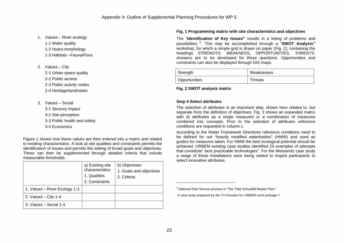
Figure 1 shows how these values are then entered into a matrix and related to existing characteristics. A look at site qualities and constraints permits the identification of issues and permits the setting of broad goals and objectives. These can then be supplemented through detailed criteria that include measurable thresholds.
a) Existing site characteristics 1. Qualities 2. Constraints
b) Objectives 1. Goals and objectives 2. Criteria
1. Values – River Ecology 1-3 2. Values – City 1-4 3. Values – Social 1-4
Fig. 1 Programming matrix with site characteristics and objectives
The “Identification of Key Issues” results in a listing of problems and possibilities 6. This may be accomplished through a “SWOT Analysis” workshop, for which a simple grid is drawn on paper (Fig. 2), containing the headings STRENGTH, WEAKNESS, OPPORTUNITIES, THREATS. Answers are to be developed for these questions. Opportunities and constraints can also be displayed through GIS maps.
Fig. 2 SWOT analysis matrix
Step 4 Select attributes The selection of attributes is an important step, shown here related to, but separate from the definition of objectives. Fig. 3 shows an expanded matrix with d) attributes as a single measures or a combination of measures combined into concepts. Prior to the selection of attributes reference conditions are requested in column c. According to the Water Framework Directives reference conditions need to be defined for not “heavily modified waterbodies” (HMW) and used as guides for measures taken. For HMW the best ecological potential should be achieved. URBEM existing case studies identified 23 examples of attempts that constitute“ best practicable technologies”. For the Weisseritz case study a range of these installations were being visited to inspire participants to select innovative attributes.
6 National Park Service process in “The Tidal Schuylkill Master Plan.”
A case study prepared by the TU Dresden for URBEM word package 7.
Strength Weaknesses
Opportunities Threats
Appendix 4: Outline of Supplemental Planning Procedures for WP 5
24
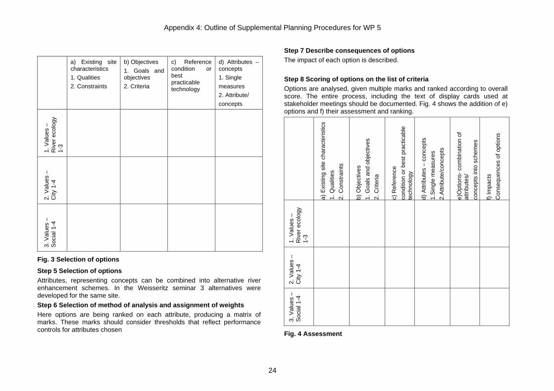
a) Existing site characteristics 1. Qualities 2. Constraints
b) Objectives 1. Goals and objectives 2. Criteria
c) Reference condition or best practicable technology
d) Attributes – concepts 1. Single measures 2. Attribute/ concepts
1. V
alue
s –
Riv
er e
colo
gy
1-3
2. V
alue
s –
City
1-4
3. V
alue
s –
Soc
ial 1
-4
Fig. 3 Selection of options
Step 5 Selection of options Attributes, representing concepts can be combined into alternative river enhancement schemes. In the Weisseritz seminar 3 alternatives were developed for the same site. Step 6 Selection of method of analysis and assignment of weights Here options are being ranked on each attribute, producing a matrix of marks. These marks should consider thresholds that reflect performance controls for attributes chosen
Step 7 Describe consequences of options The impact of each option is described. Step 8 Scoring of options on the list of criteria Options are analysed, given multiple marks and ranked according to overall score. The entire process, including the text of display cards used at stakeholder meetings should be documented. Fig. 4 shows the addition of e) options and f) their assessment and ranking.
a) E
xist
ing
site
cha
ract
eris
tics
1. Q
ualit
ies
2. C
onst
rain
ts
b) O
bjec
tives
1.
Goa
ls a
nd o
bjec
tives
2.
Crit
eria
c) R
efer
ence
co
nditi
on o
r bes
t pra
ctic
able
te
chno
logy
d) A
ttrib
utes
– c
once
pts
1.S
ingl
e m
easu
res
2.
Attr
ibut
e/co
ncep
ts
e)O
ptio
ns- c
ombi
natio
n of
at
tribu
tes/
co
ncep
ts in
to s
chem
es
f) Im
pact
s C
onse
quen
ces
of o
ptio
ns
1. V
alue
s –
Riv
er e
colo
gy
1-3
2. V
alue
s –
City
1-4
3. V
alue
s –
Soc
ial 1
-4
Fig. 4 Assessment