Embed Size (px)
Citation preview

Testbed-12 General Feature ModelEngineering Report

Table of Contents1. Introduction . . . . . . . . . . . . . . . . . . . . . . . . . . . . . . . . . . . . . . . . . . . . . . . . . . . . . . . . . . . . . . . . . . . . . . . . . . . . . 6
1.1. Scope . . . . . . . . . . . . . . . . . . . . . . . . . . . . . . . . . . . . . . . . . . . . . . . . . . . . . . . . . . . . . . . . . . . . . . . . . . . . . . . . 6
1.2. Document contributor contact points . . . . . . . . . . . . . . . . . . . . . . . . . . . . . . . . . . . . . . . . . . . . . . . . . . . 7
1.3. Future Work . . . . . . . . . . . . . . . . . . . . . . . . . . . . . . . . . . . . . . . . . . . . . . . . . . . . . . . . . . . . . . . . . . . . . . . . . 7
1.4. Foreword . . . . . . . . . . . . . . . . . . . . . . . . . . . . . . . . . . . . . . . . . . . . . . . . . . . . . . . . . . . . . . . . . . . . . . . . . . . . 8
2. References . . . . . . . . . . . . . . . . . . . . . . . . . . . . . . . . . . . . . . . . . . . . . . . . . . . . . . . . . . . . . . . . . . . . . . . . . . . . . . . 9
3. Terms and definitions. . . . . . . . . . . . . . . . . . . . . . . . . . . . . . . . . . . . . . . . . . . . . . . . . . . . . . . . . . . . . . . . . . . . 10
3.1. Abbreviated terms . . . . . . . . . . . . . . . . . . . . . . . . . . . . . . . . . . . . . . . . . . . . . . . . . . . . . . . . . . . . . . . . . . . 10
4. Overview . . . . . . . . . . . . . . . . . . . . . . . . . . . . . . . . . . . . . . . . . . . . . . . . . . . . . . . . . . . . . . . . . . . . . . . . . . . . . . . 11
5. Initial Requirements, Assumptions and Concepts . . . . . . . . . . . . . . . . . . . . . . . . . . . . . . . . . . . . . . . . . . . 12
5.1. Integration of Data, Analytical Observations and Judgments . . . . . . . . . . . . . . . . . . . . . . . . . . . . . 12
5.2. Correlation does not necessarily mean causation . . . . . . . . . . . . . . . . . . . . . . . . . . . . . . . . . . . . . . . 13
5.3. Making Judgments on Facts . . . . . . . . . . . . . . . . . . . . . . . . . . . . . . . . . . . . . . . . . . . . . . . . . . . . . . . . . . . 13
5.4. Interaction with an Integrated Information Environment . . . . . . . . . . . . . . . . . . . . . . . . . . . . . . . 13
5.4.1. Activity Based Intelligence (ABI) . . . . . . . . . . . . . . . . . . . . . . . . . . . . . . . . . . . . . . . . . . . . . . . . . . 14
5.4.2. Object Based Production (OBP) . . . . . . . . . . . . . . . . . . . . . . . . . . . . . . . . . . . . . . . . . . . . . . . . . . . . 14
5.4.3. Structured Observation Management (SOM) . . . . . . . . . . . . . . . . . . . . . . . . . . . . . . . . . . . . . . . 14
5.5. Relationships - Features and Associations . . . . . . . . . . . . . . . . . . . . . . . . . . . . . . . . . . . . . . . . . . . . . . 14
5.6. Use Case Scenario. . . . . . . . . . . . . . . . . . . . . . . . . . . . . . . . . . . . . . . . . . . . . . . . . . . . . . . . . . . . . . . . . . . . 14
5.7. Available Scenario Phases . . . . . . . . . . . . . . . . . . . . . . . . . . . . . . . . . . . . . . . . . . . . . . . . . . . . . . . . . . . . 15
5.8. Scenario Script . . . . . . . . . . . . . . . . . . . . . . . . . . . . . . . . . . . . . . . . . . . . . . . . . . . . . . . . . . . . . . . . . . . . . . 16
5.9. Accommodating Associations in GFM . . . . . . . . . . . . . . . . . . . . . . . . . . . . . . . . . . . . . . . . . . . . . . . . . . 17
5.10. WOS Approaches . . . . . . . . . . . . . . . . . . . . . . . . . . . . . . . . . . . . . . . . . . . . . . . . . . . . . . . . . . . . . . . . . . . 19
5.10.1. CSW ebRIM based WOS Approach . . . . . . . . . . . . . . . . . . . . . . . . . . . . . . . . . . . . . . . . . . . . . . . . 20
5.10.2. WFS based WOS Approach . . . . . . . . . . . . . . . . . . . . . . . . . . . . . . . . . . . . . . . . . . . . . . . . . . . . . . 21
5.11. Client Requirements . . . . . . . . . . . . . . . . . . . . . . . . . . . . . . . . . . . . . . . . . . . . . . . . . . . . . . . . . . . . . . . . 21
5.12. Initial Implementation Experiences . . . . . . . . . . . . . . . . . . . . . . . . . . . . . . . . . . . . . . . . . . . . . . . . . . 22
5.12.1. Data Availability . . . . . . . . . . . . . . . . . . . . . . . . . . . . . . . . . . . . . . . . . . . . . . . . . . . . . . . . . . . . . . . . 22
5.12.2. Data Georeferencing . . . . . . . . . . . . . . . . . . . . . . . . . . . . . . . . . . . . . . . . . . . . . . . . . . . . . . . . . . . . 22
6. The General Feature Model . . . . . . . . . . . . . . . . . . . . . . . . . . . . . . . . . . . . . . . . . . . . . . . . . . . . . . . . . . . . . . . 23
6.1. Geographic Information: Key Principles . . . . . . . . . . . . . . . . . . . . . . . . . . . . . . . . . . . . . . . . . . . . . . . 23
6.2. Metamodel for Geographic Information: The General Feature Model . . . . . . . . . . . . . . . . . . . . . 23
7. CSW-eb-RIM based WOS Implementation . . . . . . . . . . . . . . . . . . . . . . . . . . . . . . . . . . . . . . . . . . . . . . . . . . 27
7.1. Interaction Model. . . . . . . . . . . . . . . . . . . . . . . . . . . . . . . . . . . . . . . . . . . . . . . . . . . . . . . . . . . . . . . . . . . . 28
7.2. Searching for WOS Objects . . . . . . . . . . . . . . . . . . . . . . . . . . . . . . . . . . . . . . . . . . . . . . . . . . . . . . . . . . . 28
7.3. Interrogation of a WOS Object . . . . . . . . . . . . . . . . . . . . . . . . . . . . . . . . . . . . . . . . . . . . . . . . . . . . . . . . 28
7.4. Object Insertion . . . . . . . . . . . . . . . . . . . . . . . . . . . . . . . . . . . . . . . . . . . . . . . . . . . . . . . . . . . . . . . . . . . . . 29
7.5. Update and Deletion . . . . . . . . . . . . . . . . . . . . . . . . . . . . . . . . . . . . . . . . . . . . . . . . . . . . . . . . . . . . . . . . . 29

8. WFS based Web Object Service . . . . . . . . . . . . . . . . . . . . . . . . . . . . . . . . . . . . . . . . . . . . . . . . . . . . . . . . . . . 30
8.1. Introduction . . . . . . . . . . . . . . . . . . . . . . . . . . . . . . . . . . . . . . . . . . . . . . . . . . . . . . . . . . . . . . . . . . . . . . . . 30
8.2. Requirements . . . . . . . . . . . . . . . . . . . . . . . . . . . . . . . . . . . . . . . . . . . . . . . . . . . . . . . . . . . . . . . . . . . . . . . 30
8.3. Architecture. . . . . . . . . . . . . . . . . . . . . . . . . . . . . . . . . . . . . . . . . . . . . . . . . . . . . . . . . . . . . . . . . . . . . . . . . 31
8.4. Basic Service Elements . . . . . . . . . . . . . . . . . . . . . . . . . . . . . . . . . . . . . . . . . . . . . . . . . . . . . . . . . . . . . . . 31
8.4.1. Service Root . . . . . . . . . . . . . . . . . . . . . . . . . . . . . . . . . . . . . . . . . . . . . . . . . . . . . . . . . . . . . . . . . . . . . 31
8.4.2. Object Representation . . . . . . . . . . . . . . . . . . . . . . . . . . . . . . . . . . . . . . . . . . . . . . . . . . . . . . . . . . . . 31
8.4.3. Content Negotiation . . . . . . . . . . . . . . . . . . . . . . . . . . . . . . . . . . . . . . . . . . . . . . . . . . . . . . . . . . . . . . 32
8.4.4. Exceptions . . . . . . . . . . . . . . . . . . . . . . . . . . . . . . . . . . . . . . . . . . . . . . . . . . . . . . . . . . . . . . . . . . . . . . 32
8.5. Authentication and Access Control . . . . . . . . . . . . . . . . . . . . . . . . . . . . . . . . . . . . . . . . . . . . . . . . . . . . 32
8.6. Hypermedia Controls . . . . . . . . . . . . . . . . . . . . . . . . . . . . . . . . . . . . . . . . . . . . . . . . . . . . . . . . . . . . . . . . 33
8.6.1. Introduction. . . . . . . . . . . . . . . . . . . . . . . . . . . . . . . . . . . . . . . . . . . . . . . . . . . . . . . . . . . . . . . . . . . . . 33
8.6.2. Hypermedia Control in a WOS' Capabilities Document . . . . . . . . . . . . . . . . . . . . . . . . . . . . . . 33
8.6.3. Hypermedia Controls in a WOS' Query Response . . . . . . . . . . . . . . . . . . . . . . . . . . . . . . . . . . . 33
8.7. Summary of Resources . . . . . . . . . . . . . . . . . . . . . . . . . . . . . . . . . . . . . . . . . . . . . . . . . . . . . . . . . . . . . . . 33
8.8. MIME Types . . . . . . . . . . . . . . . . . . . . . . . . . . . . . . . . . . . . . . . . . . . . . . . . . . . . . . . . . . . . . . . . . . . . . . . . . 34
8.9. A Word about Examples . . . . . . . . . . . . . . . . . . . . . . . . . . . . . . . . . . . . . . . . . . . . . . . . . . . . . . . . . . . . . . 34
8.10. Service Metadata . . . . . . . . . . . . . . . . . . . . . . . . . . . . . . . . . . . . . . . . . . . . . . . . . . . . . . . . . . . . . . . . . . . 35
8.10.1. Introduction. . . . . . . . . . . . . . . . . . . . . . . . . . . . . . . . . . . . . . . . . . . . . . . . . . . . . . . . . . . . . . . . . . . . 35
8.10.2. Resources . . . . . . . . . . . . . . . . . . . . . . . . . . . . . . . . . . . . . . . . . . . . . . . . . . . . . . . . . . . . . . . . . . . . . . 35
8.10.3. Query Parameters . . . . . . . . . . . . . . . . . . . . . . . . . . . . . . . . . . . . . . . . . . . . . . . . . . . . . . . . . . . . . . 35
8.10.4. Representations . . . . . . . . . . . . . . . . . . . . . . . . . . . . . . . . . . . . . . . . . . . . . . . . . . . . . . . . . . . . . . . . 35
8.10.5. Methods . . . . . . . . . . . . . . . . . . . . . . . . . . . . . . . . . . . . . . . . . . . . . . . . . . . . . . . . . . . . . . . . . . . . . . . 36
8.10.6. Examples . . . . . . . . . . . . . . . . . . . . . . . . . . . . . . . . . . . . . . . . . . . . . . . . . . . . . . . . . . . . . . . . . . . . . . 36
8.11. Object Access & Management (GetObject/Transaction) . . . . . . . . . . . . . . . . . . . . . . . . . . . . . . . . . 41
8.11.1. Introduction. . . . . . . . . . . . . . . . . . . . . . . . . . . . . . . . . . . . . . . . . . . . . . . . . . . . . . . . . . . . . . . . . . . . 41
8.11.2. Resources . . . . . . . . . . . . . . . . . . . . . . . . . . . . . . . . . . . . . . . . . . . . . . . . . . . . . . . . . . . . . . . . . . . . . . 41
8.11.3. Query parameters . . . . . . . . . . . . . . . . . . . . . . . . . . . . . . . . . . . . . . . . . . . . . . . . . . . . . . . . . . . . . . 42
8.11.4. Representations . . . . . . . . . . . . . . . . . . . . . . . . . . . . . . . . . . . . . . . . . . . . . . . . . . . . . . . . . . . . . . . . 42
8.11.5. Methods . . . . . . . . . . . . . . . . . . . . . . . . . . . . . . . . . . . . . . . . . . . . . . . . . . . . . . . . . . . . . . . . . . . . . . . 43
8.11.6. Examples: . . . . . . . . . . . . . . . . . . . . . . . . . . . . . . . . . . . . . . . . . . . . . . . . . . . . . . . . . . . . . . . . . . . . . . 44
8.12. Associations . . . . . . . . . . . . . . . . . . . . . . . . . . . . . . . . . . . . . . . . . . . . . . . . . . . . . . . . . . . . . . . . . . . . . . . . 47
8.12.1. Introduction. . . . . . . . . . . . . . . . . . . . . . . . . . . . . . . . . . . . . . . . . . . . . . . . . . . . . . . . . . . . . . . . . . . . 47
8.12.2. Resources . . . . . . . . . . . . . . . . . . . . . . . . . . . . . . . . . . . . . . . . . . . . . . . . . . . . . . . . . . . . . . . . . . . . . . 47
8.12.3. Methods . . . . . . . . . . . . . . . . . . . . . . . . . . . . . . . . . . . . . . . . . . . . . . . . . . . . . . . . . . . . . . . . . . . . . . . 49
8.12.4. Examples . . . . . . . . . . . . . . . . . . . . . . . . . . . . . . . . . . . . . . . . . . . . . . . . . . . . . . . . . . . . . . . . . . . . . . 50
8.13. Classifications . . . . . . . . . . . . . . . . . . . . . . . . . . . . . . . . . . . . . . . . . . . . . . . . . . . . . . . . . . . . . . . . . . . . . . 52
8.13.1. Introduction. . . . . . . . . . . . . . . . . . . . . . . . . . . . . . . . . . . . . . . . . . . . . . . . . . . . . . . . . . . . . . . . . . . . 52
8.13.2. Resources . . . . . . . . . . . . . . . . . . . . . . . . . . . . . . . . . . . . . . . . . . . . . . . . . . . . . . . . . . . . . . . . . . . . . . 53
8.13.3. Methods . . . . . . . . . . . . . . . . . . . . . . . . . . . . . . . . . . . . . . . . . . . . . . . . . . . . . . . . . . . . . . . . . . . . . . . 56
8.13.4. Examples . . . . . . . . . . . . . . . . . . . . . . . . . . . . . . . . . . . . . . . . . . . . . . . . . . . . . . . . . . . . . . . . . . . . . . 58

9. Future Work . . . . . . . . . . . . . . . . . . . . . . . . . . . . . . . . . . . . . . . . . . . . . . . . . . . . . . . . . . . . . . . . . . . . . . . . . . . . 61
Appendix A: Revision History . . . . . . . . . . . . . . . . . . . . . . . . . . . . . . . . . . . . . . . . . . . . . . . . . . . . . . . . . . . . . . . 63
Appendix B: Bibliography . . . . . . . . . . . . . . . . . . . . . . . . . . . . . . . . . . . . . . . . . . . . . . . . . . . . . . . . . . . . . . . . . . 64

Publication Date: 2017-05-12
Approval Date: 2016-12-07
Posted Date: 2016-11-21
Reference number of this document: OGC 16-047r1
Reference URL for this document: http://www.opengis.net/doc/PER/t12-A075
Category: Public Engineering Report
Editor: Martin Klopfer
Title: Testbed-12 General Feature Model Engineering Report
Testbed-12 General Feature Model Engineering Report (16-047r1)
COPYRIGHT
Copyright © 2017 Open Geospatial Consortium. To obtain additional rights ofuse, visit http://www.opengeospatial.org/
WARNING
This document is an OGC Public Engineering Report created as a deliverable ofan initiative from the OGC Innovation Program (formerly OGC InteroperabilityProgram). It is not an OGC standard and not an official position of the OGCmembership.It is distributed for review and comment. It is subject to changewithout notice and may not be referred to as an OGC Standard. Further, anyOGC Engineering Report should not be referenced as required or mandatorytechnology in procurements. However, the discussions in this document couldvery well lead to the definition of an OGC Standard.
1

LICENSE AGREEMENT
Permission is hereby granted by the Open Geospatial Consortium, ("Licensor"),free of charge and subject to the terms set forth below, to any person obtaining acopy of this Intellectual Property and any associated documentation, to deal inthe Intellectual Property without restriction (except as set forth below),including without limitation the rights to implement, use, copy, modify, merge,publish, distribute, and/or sublicense copies of the Intellectual Property, and topermit persons to whom the Intellectual Property is furnished to do so, providedthat all copyright notices on the intellectual property are retained intact andthat each person to whom the Intellectual Property is furnished agrees to theterms of this Agreement.
If you modify the Intellectual Property, all copies of the modified IntellectualProperty must include, in addition to the above copyright notice, a notice thatthe Intellectual Property includes modifications that have not been approved oradopted by LICENSOR.
THIS LICENSE IS A COPYRIGHT LICENSE ONLY, AND DOES NOT CONVEY ANYRIGHTS UNDER ANY PATENTS THAT MAY BE IN FORCE ANYWHERE IN THEWORLD. THE INTELLECTUAL PROPERTY IS PROVIDED "AS IS", WITHOUTWARRANTY OF ANY KIND, EXPRESS OR IMPLIED, INCLUDING BUT NOTLIMITED TO THE WARRANTIES OF MERCHANTABILITY, FITNESS FOR APARTICULAR PURPOSE, AND NONINFRINGEMENT OF THIRD PARTY RIGHTS.THE COPYRIGHT HOLDER OR HOLDERS INCLUDED IN THIS NOTICE DO NOTWARRANT THAT THE FUNCTIONS CONTAINED IN THE INTELLECTUALPROPERTY WILL MEET YOUR REQUIREMENTS OR THAT THE OPERATION OFTHE INTELLECTUAL PROPERTY WILL BE UNINTERRUPTED OR ERROR FREE.ANY USE OF THE INTELLECTUAL PROPERTY SHALL BE MADE ENTIRELY ATTHE USER’S OWN RISK. IN NO EVENT SHALL THE COPYRIGHT HOLDER OR ANYCONTRIBUTOR OF INTELLECTUAL PROPERTY RIGHTS TO THE INTELLECTUALPROPERTY BE LIABLE FOR ANY CLAIM, OR ANY DIRECT, SPECIAL, INDIRECT ORCONSEQUENTIAL DAMAGES, OR ANY DAMAGES WHATSOEVER RESULTINGFROM ANY ALLEGED INFRINGEMENT OR ANY LOSS OF USE, DATA OR PROFITS,WHETHER IN AN ACTION OF CONTRACT, NEGLIGENCE OR UNDER ANY OTHERLEGAL THEORY, ARISING OUT OF OR IN CONNECTION WITH THEIMPLEMENTATION, USE, COMMERCIALIZATION OR PERFORMANCE OF THISINTELLECTUAL PROPERTY.
This license is effective until terminated. You may terminate it at any time by
2

destroying the Intellectual Property together with all copies in any form. Thelicense will also terminate if you fail to comply with any term or condition ofthis Agreement. Except as provided in the following sentence, no suchtermination of this license shall require the termination of any third party end-user sublicense to the Intellectual Property which is in force as of the date ofnotice of such termination. In addition, should the Intellectual Property, or theoperation of the Intellectual Property, infringe, or in LICENSOR’s sole opinion belikely to infringe, any patent, copyright, trademark or other right of a thirdparty, you agree that LICENSOR, in its sole discretion, may terminate this licensewithout any compensation or liability to you, your licensees or any other party.You agree upon termination of any kind to destroy or cause to be destroyed theIntellectual Property together with all copies in any form, whether held by youor by any third party.
Except as contained in this notice, the name of LICENSOR or of any other holderof a copyright in all or part of the Intellectual Property shall not be used inadvertising or otherwise to promote the sale, use or other dealings in thisIntellectual Property without prior written authorization of LICENSOR or suchcopyright holder. LICENSOR is and shall at all times be the sole entity that mayauthorize you or any third party to use certification marks, trademarks or otherspecial designations to indicate compliance with any LICENSOR standards orspecifications.
This Agreement is governed by the laws of the Commonwealth of Massachusetts.The application to this Agreement of the United Nations Convention onContracts for the International Sale of Goods is hereby expressly excluded. Inthe event any provision of this Agreement shall be deemed unenforceable, voidor invalid, such provision shall be modified so as to make it valid andenforceable, and as so modified the entire Agreement shall remain in full forceand effect. No decision, action or inaction by LICENSOR shall be construed to bea waiver of any rights or remedies available to it.
None of the Intellectual Property or underlying information or technology maybe downloaded or otherwise exported or reexported in violation of U.S. exportlaws and regulations. In addition, you are responsible for complying with anylocal laws in your jurisdiction which may impact your right to import, export oruse the Intellectual Property, and you represent that you have complied withany regulations or registration procedures required by applicable law to makethis license enforceable.
3
Abstract
With a growing requirement to carry out complex analysis in large multi-disciplinary, heterogeneous data collections, an approach is required to extractequivalent information from dissimilar content. The more information can benormalized, the easier it will be to correlate the content. Given that almost alldata has a spatio-temporal component, this ER will look into the idea of defininga Spatial-Temporal Service and analyze which collection of data types,operations and architecture patterns would be necessary to spatial-temporalenable any content. This OGC® document reviews the General Feature Modeland gives guidelines for necessary modifications to broaden its scope, so that itcan be re-used for non-geospatial centric applications and extended asnecessary into a general model for all object types.
Business Value
The GFM and it’s capabilities have long been regarded as being of interest to theOGC / the geospatial community only. However, the proof-of-concept carried outin this activity has successfully demonstrated, that the GFM can accommodatefar more requirements than anticipated. Even rather abstract items such as ajudgement, a decision or the related body of evidence can be expressed asfeatures and associations. Given that almost all information can be attributedwith some spatio-temporal tag, a GFM based approach can play an importantrole in the integration of geospatial and non-geospatial data and systems.
Technology Value
This ER summarizes the work performed in Testbed-12 and provides an outlookon possible future activities. It serves as a starting point for the OGC communityin general and the Geosemantics Working Group in particular to understandsome of the latest discussions on semantics in geospatial contexts. It provides anumber of references to more detailed material to facilitate more in-depthresearch and analysis.
Although this ER does not reflect the work of any OGC Working Group, itaddresses topics which are currently discussed in the Defense & IntelligenceDWG, Disaster Management DWG and Big Data DWG. The initial GEOINTrequirements were derived from capabilities anticipated for Activity BasedIntelligence (ABI), Object Based Production (OBP) and Structured ObservationManagement (SOM). It concentrates on summarizing the activities performed inTestbed-12 that were carried out to analyze the capabilities of the GFM to storenon-geospatial data and associations. As such it provides a starting point for
4

future work on geospatial and non-geospatial data integration.
Keywords
ogcdocs, testbed-12, General Feature Model, heterogeneous data integration
Proposed OGC Working Group for Review and Approval
WFS/FES SWG and Defence and Intelligence DWG
5

Chapter 1. Introduction
1.1. ScopeGiven that almost all data has a spatial-temporal component, this OGC® Engineering Reportevaluates the degree to which the General Feature Model can accommodate complex analysis onlarge multi-disciplinary, heterogeneous data collections for the purpose of extracting newinformation from dissimilar content. It looks into the idea of defining a Spatial-Temporal Serviceand Analytics platform and identifies the data types, operations and architecture patterns would benecessary to spatial-temporal enable any type of content.
This OGC® document reviews the General Feature Model and gives guidelines for necessarymodifications to broaden its scope, so that it can be re-used for non-geospatial centric applicationsand extended as necessary into a general model for all object types.
The idea to integrate information and capture knowledge has evolved in OGC over a long period oftime, accommodating the continuous changes in technology and the range of services to beintegrated. The following OGC documents summarize some of this work and have been consideredin the development of the initial concepts:
The Web Object Service Implementation Specification (OGC 02-049 / 03-013) aimed to satisfy arequirement of the OWS 1.2 project to manage many different types of objects, including styles,symbols and images, using a repository interface. “The specification defines a set of base XMLtypes that define the behavior of a Web Object Service. A Web Object Service is a generic web-based repository interface. The interface supports the following operations: GetCapabilities,DescribeObjectType, GetObjectById, GetObject, LockObject and Transaction. The specificationassumes that the distributed computing platform is HTTP and may define both XML (suitable forthe POST method) and Keyword-Value Pair (suitable for the GET method) encodings of eachoperation.”
The OGC® Testbed-10 Service Integration Engineering Report (OGC 14-13r1) “specifies a means ofdiscovering and describing associations between web resources (both OGC and non-OGC). Thediscovery of associations is accomplished by means a new operation named GetAssociations. Thedescription or representation of associations is accomplished by the definition of an XML Schemafor expressing associations in XML. The scope of this document is limited to the existing OGC webservice framework, which predominantly uses XML. However, it is anticipated that over time theassociation schemas defined in this document will be extended to provide JSON snd JSON-LDexpressions which are rapidly emerging encodings within and outside the OGC.”
The OGC® Testbed-11 Incorporating Social Media in Emergency Response Engineering Report (OGC15-057) studies two different approaches to incorporating social media information into EmergencyResponse applications: “The first [approach] was based on the concept of using an OGC SensorObservation Service (SOS) for handling humans as sensors is illustrated from an interoperabilityperspective. The developed O&M-based data model is presented and illustrated with examples fromdifferent social media platforms. This is complemented by a description of how data loading fromsocial media platforms into an SOS server can be achieved. The second approach was based onusing Linked Data to integrate social objects produced by the different social media networks. Theontology for describing social objects and activities is based on SocialML ontologies that can be
6

extended to accommodate new activities and social objects. The integration of social sites was donethrough the use of RDF scrapers accessible through a REST API. The resulting knowledgebase wasmade available through a GeoSPARQL endpoint. Another important topic of [OGC 15-057] is the useof the OGC Web Processing Service (WPS) for analyzing the available social media data (i.e. detectclusters). “
However, the requirement to integrate heterogenous data using spatial-temporal attributes has alsobeen addressed outside the OGC. One example explicitly mentioned in the Testbed-12 RFQ is theFGDC endorsed Time Space Position Information (TSPI) Version 2.0 standard (NGA.STND.0019_2.0),which "provides a single means of encoding spatiotemporal information for the storage,manipulation, interchange, and exploitation of spatiotemporal data. It is designed as a set ofreusable data components upon which both Geography Markup Language (GML)-based applicationschemas and non-GML-based XML schemas may be developed. It specifies a registry-basedextension mechanism enabling the development and reuse of additional spatiotemporal XMLSchema components. It integrates the XML Schema for the United States Thoroughfare, Landmark,and Postal Address Data Standard, FGDC-STD-016-2011, including the necessary updates to workwith the OGC® GML 3.3, Extended schemas and encoding rules."
The Testbed-12 General Feature Model ER now takes a step back from specific implementationrequirements and looks into the principle capabilities of the GFM to accommodate non-geospatialdata, information and associations as features.
A simple use case scenario is based on observations from non-geospatial sources, subsequentdecisions based on selected observations and a requirement to create associations, which allow auser to access all associated features. The objective is to make a body of evidence for a decisionaccessible from various angles. This can be the traditional geospatial approach of showing adecision on a map and providing a report of associated features. However it should also be capableof providing graph-like overviews of features and associations accessible from non-geospatialsystems.
1.2. Document contributor contact pointsAll questions regarding this document should be directed to the editor or the contributors:
Table 1. Contacts
Name Organization
Roger Brackin Envitia
Charles Heazel WiSC Enterprises
Gobe Hobona PhD. Envitia
Martin Klopfer Frisia IT
Panagiotis (Peter) A. Vretanos CubeWerx Inc.
1.3. Future WorkThis initiative has demonstrated the feasibility of a Spatial-Temporal Service and Analytics Platform
7

based on the General Feature Model. However, much work remains to be done to fully define andvalidate that platform. The proposed next steps in this effort can be found in Section 9.
The work carried out in this activity has not resulted in any change requests towards existingspecifications.
1.4. ForewordAttention is drawn to the possibility that some of the elements of this document may be the subjectof patent rights. The Open Geospatial Consortium shall not be held responsible for identifying anyor all such patent rights.
Recipients of this document are requested to submit, with their comments, notification of anyrelevant patent claims or other intellectual property rights of which they may be aware that mightbe infringed by any implementation of the standard set forth in this document, and to providesupporting documentation.
8

Chapter 2. ReferencesThe following documents are referenced in this document. For dated references, subsequentamendments to, or revisions of, any of these publications do not apply. For undated references, thelatest edition of the normative document referred to applies.
• OGC OGC 06-121r9, OWS Common Implementation Standard
• OGC 16-046, Testbed-12 Semantic Enablement ER
• OGC 02-049 / 03-013, Web Object Service Implementation Specification
• OGC 14-13r1, Testbed-10 Service Integration Engineering Report
• OGC 15-057, Testbed-11 Incorporating Social Media in Emergency Response Engineering Report
• NGA.STND.0019_2.0, Time Space Position Information (TSPI) Version 2.0 standard
• NGA, Everything you wanted to know about the NSG Application Schema (NAS), TB12 ReferenceMaterial Presentation
9

Chapter 3. Terms and definitionsFor the purposes of this report, the definitions specified in Clause 4 of the OWS CommonImplementation Standard [OGC 06-121r9] shall apply. In addition, the following terms anddefinitions apply.
3.1. Abbreviated terms• ABI Activity Based Intelligence
• API Application Program Interface
• COM Component Object Model
• CSW Catalogue Service for the Web
• DCE Distributed Computing Environment
• DCOM Distributed Component Object Model
• ebRIMElectronic Business Registry Information Model
• ER Engineering Report
• GFM General Feature Model
• GMLSF Simple Feature Geography Markup Language
• IDL Interface Definition Language
• LDP Linked Data Platform
• NGA National Geospatial-Intelligence Agency
• OBP Object Based Production
• OWL Web Ontology Language
• OWL-S Semantic Markup for Web Services
• RDF Resources Description Format
• RDF-QB RDF Data Cube
• SHACL Shapes Constraint Language
• SKOS Simple Knowledge Organization System
• SOM Structured Object Management
• SPARQL SPARQL Protocol and RDF Query Language
• UML Unified Modeling Language
• VoID Vocabulary of Interlinked Datasets
• WOS Web Object Service
10

Chapter 4. OverviewThis ER serves as an entry point to Testbed-12 activities looking into the idea of using the GFM as abasis for integration of heterogeneous and multi-temporal geospatial and non-geospatial data. Itintegrates discussions from the Linked Data and Advanced Semantics for Data Discovery andDynamic Integration thread.
The main document starts in Clause 5 with a short overview of the initial requirements,assumptions and concepts, as well as the use case scenario selected for a proof of conceptdemonstration.
It then maps the concepts to the use case scenario and derives an initial model based on the GFM inClause 6.
Two demo implementations carried out by Envitia and Cubewerx are briefly described anddiscussed in Clause 7 and Clause 8.
The experiences from the proof of concept implementations as well as future work items are finallysummarized inClause 9.
11
Chapter 5. Initial Requirements,Assumptions and ConceptsWith a growing requirement to carry out complex analysis in large multi-disciplinary,heterogeneous data collections, an approach is required to extract equivalent information fromdissimilar content. The more information can be normalized, the easier it will be to correlate thecontent.
Given that almost all data has a spatio-temporal component, this ER looks into the idea of defining aSpatial-Temporal Platform as a Web Object Service (WOS) and analyzes which collection of datatypes, operations and architecture patterns would be necessary to spatial-temporal enable anycontent.
It is assumed that the General Feature Model, WFS and CSW already accommodate mostcapabilities, although by nature of their origin, they are primarily geared towards geospatialapplication.
The envisioned WOS is not about merging WFS and CSW. It is about being able to serve any type ofobject, e.g. vector features, raster coverages, other images, sounds, or even representations of aconcept or conclusion.
The WOS is thus a means to handle associations as a first class object to allow the description ofrelationships between arbitrary objects in a formal way as described below.
The goal is to review the General Feature Model and to research necessary modifications tobroaden its scope, so that it can be re-used for non-geospatial centric applications and extended asnecessary into a general model for all object types.
5.1. Integration of Data, Analytical Observations andJudgmentsAs part of their homeland security mission, NGA has compiled the HSIP Gold database. HSIP Gold isa compilation of 560 of the best available geospatially enabled baseline infrastructure datasets forall National & Defense Critical Infrastructure Sectors. Now they want to extend that capability byproviding not just feature data, but a comprehensive integrated information environment. Thisenvironment provides a comprehensive suite of integrated information as well as analytics toderive knowledge from that information.
Central to this capability is a data aggregation service: Data is collected from open source, crowdsources, and procured from key data providers.
All data is assigned a unique identifier, and populated with discovery metadata. That metadataincludes the spatial and temporal extent. Core to the data store is a global feature data set. Thisfoundation feature data is a detailed representation of the global real-world objects. The foundationfeature data provides a spatial-temporal context against which all other data can be understood.
The data holdings do not stop with data. They also include the results of analytic processes applied
12

to the data. These results are classified as observations or judgments.
5.2. Correlation does not necessarily mean causationObservations identify correlations between data. These may be generated by observation orthrough automated analytics. Correlations are statements of fact, but do not indicate meaning.
For example, two suspected criminal operatives are in San Francisco at the same time and stayed inhotels within ½ mile from each other. This could indicate that they are planning an attack. It couldbe simple coincidence. The observation is a simple observance of fact. It makes no judgment as tothe significance of that fact.
5.3. Making Judgments on FactsJudgments are the result of analytic processes, which develop conclusions from a body of evidence.They can be the result of automated or human analytic processes. A judgment must include:
• the entity which generated the judgment,
• the analytic process used,
• the body of evidence supporting the judgment, which can include data, observations and otherjudgments,
• a measure of confidence for the judgment, which should reflect the aggregate confidence ineach evidence entity, as well as the confidence in the analytic process. A change in any of theevidence should result in a re-calculation of, or at last a flag against, the confidence in thejudgment.
This information is sufficient for a user to review the analytic process and make their ownassessment as to its value.
5.4. Interaction with an Integrated InformationEnvironmentData, observations and judgments reside in the integrated information environment and allinformation is spatial-temporally enabled.
This information can be compiled for distribution through a report, i.e. a compilation ofobservations and judgments intended for human consumption. However, such reports do not haveto be in a document format. A report may also be an interactive web site, which allows users tovisualize and navigate through the judgments and reasoning. They may also be dynamicallyupdated as the underlying information changes.
Users can build their own analytics or use the analytics provided by the service. Analytics can beassembled into workflows resulting in more complex analytics.
This concept is also well described in NGA’s presentation ""Everything you wanted to know aboutthe NSG Application Schema (NAS)"". The NAS document describes three major components of this
13

integrated information environment:
5.4.1. Activity Based Intelligence (ABI)
An analytic method applied to structured data from all sources, to discover objects, relationships, orbehaviors by resolving significant activity. ABI methods accelerate and deepen insight and theability to do OBP; new insight enriches models and understanding of adversary behaviors andrelationships.
5.4.2. Object Based Production (OBP)
A framework for organizing and sharing information, relating observations from all sources toknown objects (be they units, people, locations, or events).
5.4.3. Structured Observation Management (SOM)
NGA’s framework for organizing and sharing GEOINT information, normalizing how to capture andrecord observations from all sensors and sources. SOM enables integration of GEOINT in OBP.
5.5. Relationships - Features and AssociationsBased on the above mentioned conceptual ideas a feature can be almost anything. To illustrate theconcept, the chosen data for the Use Case Scenario described below includes analyticalobservations, judgements, tweets, images and even a police radio message.
The crucial step is to move from individual features to linked features. The association describesthe relationship between features and is thus the binding connection, linking objects with eachother. This GFM approach works with every type of relationship.
The topic of associations has also come up in other TB12 activities and is further described in TB12 -Evaluate Semantic Enablement ER.
5.6. Use Case ScenarioTo evaluate the degree to which the GFM is capable of capturing information from social media andrelated human judgments and decisions as features, a simple use case scenario has been developed:
• A large crowd moves from A to B along a predefined route,
• an incident, which could temporarily block the anticipated route is reported,
• the situation needs to be judged and
• decisions need to be taken and potentially justified later on.
Apart from the fabricated incident at the junction, this is based on a Climate Change Protest Marchwith 5,000+ participants. The event took place in Oakland on 7th February 2015. It was well coveredby tweets before, during and after the event via @DontFrackCA.
14
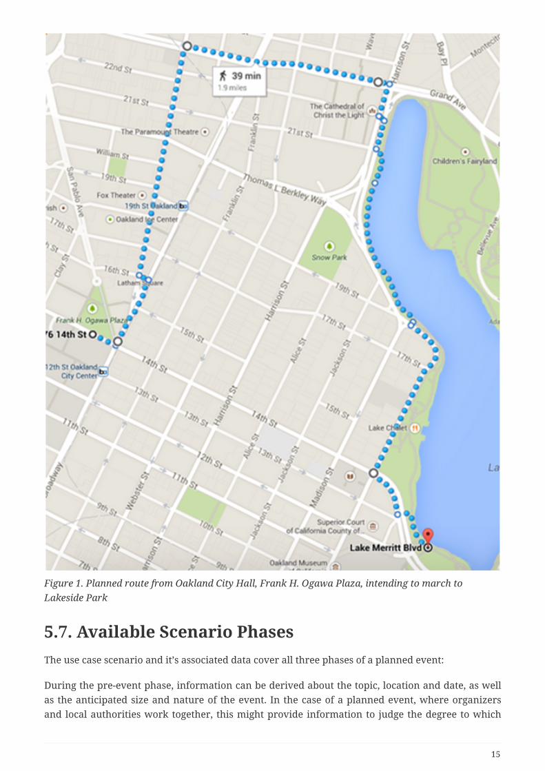
Figure 1. Planned route from Oakland City Hall, Frank H. Ogawa Plaza, intending to march toLakeside Park
5.7. Available Scenario PhasesThe use case scenario and it’s associated data cover all three phases of a planned event:
During the pre-event phase, information can be derived about the topic, location and date, as wellas the anticipated size and nature of the event. In the case of a planned event, where organizersand local authorities work together, this might provide information to judge the degree to which
15

planned and actual developments align. In case of an ad hoc event, it could provide early warningindicators to trigger actions for preparedness.
During the actual event phase, social media information can be used to support situationawareness and handling. For TB12 we have inserted a tweet message reporting a suspiciouspackage next to a junction the Climate Change Protest March plans to pass on the planned route.This requires organizers to make decisions how to proceed. The decisions are based on the currentlocation of the crowd, which could be machine-processed information from tweets, humanobservations reported by radio and judgments on available information. Observations, judgmentsand decisions shall all be treated a features with a traceable relationship to each other.
Post-event information might be relevant to rate the effectiveness of decisions resulting actions.
5.8. Scenario ScriptGiven that the scope of the GFM activity in TB12 is to proof the concept of storing heterogeneousobservations and their associations in a GFM based model, it was decided to break down thescenario to a very simple chain of events:
• A suspicious parcel is observed on a junction of the planned route and triggers a potentialthreat alert
• A decision to investigate is taken based on the location of the crowd relative to the reportedlocation
• The parcel can be identified and the threat alert is cleared
16
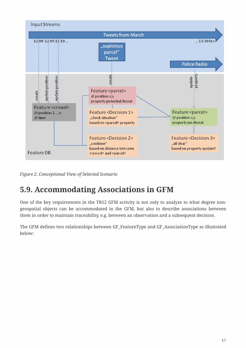
Figure 2. Conceptional View of Selected Scenario
5.9. Accommodating Associations in GFMOne of the key requirements in the TB12 GFM activity is not only to analyze to what degree non-geospatial objects can be accommodated in the GFM, but also to describe associations betweenthem in order to maintain traceability, e.g. between an observation and a subsequent decision.
The GFM defines two relationships between GF_FeatureType and GF_AssociationType as illustratedbelow:
17

Figure 3. relationships between GF_FeatureType and GF_AssociationType
The "TypeAssociation" between GF_FeatureType and GF_AssociationType indicates that aGF_AssociationType instance can serve as the "linkBetween" two GF_FeatureType instances. That is,the GF_Association "includes" the associated GF_Feature instances. Since the GF_AssociationType isa metaclass derived from GF_FeatureType, this approach allows associations to have properties(attributes, associations, and operations) analogous to any other instance of GF_FeatureType.
The second relationship between GF_FeatureType and GF_AssociationType is an inheritancerelationship. GF_AssociationType inherits all associations and properties of GF_FeatureType, itssuperclass. Since GF_AssociationType is a subclass of GF_FeatureType, then GF_Associations arealso GF_Features. If GF_Associations are also GF_Features, then there can be GF_Associationinstances which associate GF_Associations. That is, associations between associations. This leapallows us to not only establish smart associations between objects, but to build a body of evidence(a collection of objects and associations) which asserts and supports the confidence level for eachassociation.
In our example, we use this model to define additional properties for associations. TheBodyOfEvidence Association class allows us to define the trust level and a reason, as illustratedbelow:
18

Figure 4. defining properties for associations
The resulting GFM based model is detailed in Clause 6.
5.10. WOS ApproachesThe Web Object Server concept allows multi-faceted information to be stored, updated and queriedso as to effectively allow the management and exploitation of the information in an intelligenceway.
Two possible WOS approaches have been identified for evaluation in TB12:
• Based on CSW-ebRIM
• Based on WFS
Both the CSW and WFS support geographic, numeric, and textual queries based on the OGC Filterquery language. Both also deliver data in response to query requests. In the case of the WFS, thatdata is in the form of GF_Features. The CSW typically returns "metadata" records. This distinctionis one of use rather than substance. Starting with NAS version 7.0, NGA has re-integrated the NSGMetadata Foundation (NMF) back into the NAS. Metadata and Feature data become two views into
19
the same data holdings. In the same way, the WFS and CSW based WOSs can be seen as twodifferent approaches to the same capability.
5.10.1. CSW ebRIM based WOS Approach
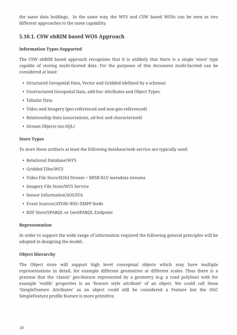
Information Types Supported
The CSW ebRIM based approach recognizes that it is unlikely that there is a single ‘store’ typecapable of storing multi-faceted data. For the purposes of this document multi-faceted can beconsidered at least:
• Structured Geospatial Data, Vector and Gridded (defined by a schema)
• Unstructured Geospatial Data, add-hoc Attributes and Object Types.
• Tabular Data
• Video and Imagery (geo-referenced and non-geo-referenced)
• Relationship Data (associations, ad-hoc and characterised)
• Stream Objects (no-SQL)
Store Types
To store these artifacts at least the following database/web service are typically used:
• Relational Database/WFS
• Gridded Files/WCS
• Video File Store/H264 Stream + MISB KLV metadata streams
• Imagery File Store/WCS Service
• Sensor Information/SOS/STA
• Event Sources/ATOM+RSS+XMPP feeds
• RDF Store/SPARQL or GeoSPARQL Endpoint
Representation
In order to support the wide range of information required the following general principles will beadopted in designing the model.
Object Hierarchy
The Object store will support high level conceptual objects which may have multiplerepresentations in detail, for example different geometries at different scales. Thus there is apremise that the ‘classic’ geo-feature represented by a geometry (e.g. a road polyline) with forexample ‘width’ properties is an ‘feature style attribute’ of an object. We could call these‘SimpleFeature Attributes’ as an object could still be considered a Feature but the OGCSimpleFeature profile feature is more primitive.
20

Feature/Attribute Schema Independence
The proposed model to store the necessary information is an object hierarchy based on Ontologicalprinciples rather than schema principles. The main conceptual difference is to break the specificlink between feature and attribute, avoiding constraining an object to have a fixed set of attributes.An object can be ‘classed’ by associating one or more classes with it, but these do not define theattribute profile. Note this also allows an instance attribute to be used by more than one object.
Globally Unique Identifier Principle
In line with ontological principles a WOS object will have a well define characterizing global id (itcan have more than one, but no one id can reference more than one object). In addition all WOSinstance attributes will also have a global id. So in the example of road above, each simpleFeatureobject will have a globally unique id. This is critical in allowing an attribute to be retrieved fromanother store.
5.10.2. WFS based WOS Approach
Cubewerx is working on a WFS-based WOS, which would be a completely new service with andedicated API. Presumably, this service would be able to handle a wide variety of object typesincluding features, catalogue records, and even coverages. Like CSW or WFS it will use the Filterencoding standard as its predicate language. The underlying data model remains to be discussed,with ATOM being a favored candidate.
As a starting point the service proposal (02-049) will be used; it was derived from WFS/CSW andwas the first attempt to move towards a unified data service (features, coverages, etc.).
5.11. Client RequirementsThe goal of a WOS client is to enable the search, discovery and exploitation of the content providedby a WOS. In contrast to other geospatial web services, a WOS is intended to support a widervariety of types of objects. This section presents those requirements that were identified in thedevelopment of the WOS demonstrations.
The primary requirement for a WOS client is the ability to present both geospatial and non-geospatial content. An example of geospatial content in a geographically referenced Building. Anexample of non-geospatial content is a Decision. In Testbed-12 geospatial content was displayedboth on a map and on a list, whereas non-geospatial content was presented on a list.
A first secondary requirement is an ability to present both text and non-text properties (i.e. multimedia such as audio and video). An example of text properties is the name or length of a road, thatis property values that can be encoded as text. Examples of non-text properties are a picture of aparcel or an audio clip.
Another secondary requirement is an ability to query and present associations between objects ofcontent stored or registered in the WOS.
21
5.12. Initial Implementation Experiences
5.12.1. Data Availability
As of September 2016, all tweets of the 2015 Oakland March were still available via the Twittersearch API. However we have not yet been able to find a definite answer to the lifetime of tweets.Whilst this might seem irrelevant to the monitoring of a live event, it has an impact on preservingthe body of evidence for decisions. For the purpose of the GFM demo, it was therefore decided toharvest a selected number of tweets and store them in a backup system to emulate the live event.Deployed in a real-time scenario, this mechanism might also be relevant to the preservation of bodyof evidence data.
5.12.2. Data Georeferencing
An analysis of the tweets selected for the scenario revealed that only very few were actuallygeoreferenced. However, georeferencing can be done based on keywords embedded in a tweet, e.g.“Front of the March now at <Fox Theatre>”, or identification of local features in pictures or videostreams.
22

Chapter 6. The General Feature ModelThe following paragraphs introducing the General Feature Model are based on [1], which evenincludes an introduction to object-oriented modeling and design. Readers not familiar with theobject-oriented paradigm are referred advised to consult [1] first. ISO/TC211 follows the modeldriven architecture approach with its fundamental concept that an application can be describedindependently of the platform on which it runs. This level of abstraction results in the developmentof conceptual models, which are used to describe aspects of the real world in an abstract way. Thesemodels always reflect the specific view of the world by the model developer and contain only theseelements from the universe of discourse that are relevant in a particular situation. Conceptualmodels have several levels of abstraction:
• Meta-metamodel level: The meta-metamodel contains the defining schema that identifies theprinciples to be used in organizing information about the concepts of interest.
• Metamodel level: The metamodel includes a specification of the language to be used indescribing the concepts. A conceptual schema language provides the semantic and syntacticelements used in a rigorous description of the conceptual model consistent with the definingschema. ISO/TC211 elected UML the conceptual schema language
• Application Level: The application level contains application schemas that describe the specificconcepts that are instantiated to produce a data set.
• Lowest Level: The lowest level is a data set that instantiates the concepts defined by anapplication schema.
6.1. Geographic Information: Key PrinciplesThe defining schema (meta-metamodel) for geographic information contains several key principles:
• The real-world entities of interest for geographic information are described as features.
• Feature characteristics are known as feature attributes. These include spatial characteristics,which are of particular importance.
• Features may be related to each other in many ways with relationships upon spatial positionbeing especially important.
• Features may perform a variety of functions in the natural or cultural environment in whichthey occur.
• A set of common characteristics, relationships, and functions common to many features definea feature type.
6.2. Metamodel for Geographic Information: TheGeneral Feature ModelThe General Feature Model (GFM) is defined as the metamodel for the development of applicationschemas for geographic information. It is defined in ISO 19109. The principal element of the GFM isthe metaclass GF_FeatureType. Metaclass is a stereotype that identifies a classifier whose instancesare themselves classes, i.e. it represents a concept at a higher level of abstraction than do the
23
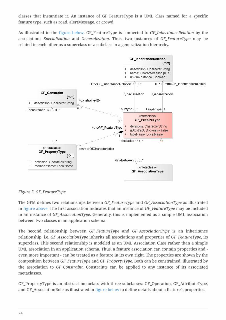
classes that instantiate it. An instance of GF_FeatureType is a UML class named for a specificfeature type, such as road, alertMessage, or crowd.
As illustrated in the figure below, GF_FeatureType is connected to GF_InheritanceRelation by theassociations Specialization and Generalization. Thus, two instances of GF_FeatureType may berelated to each other as a superclass or a subclass in a generalization hierarchy.
Figure 5. GF_FeatureType
The GFM defines two relationships between GF_FeatureType and GF_AssociationType as illustratedin figure above. The first association indicates that an instance of GF_FeatureType may be includedin an instance of GF_AssociationType. Generally, this is implemented as a simple UML associationbetween two classes in an application schema.
The second relationship between GF_FeatureType and GF_AssociationType is an inheritancerelationship, i.e. GF_AssociationType inherits all associations and properties of GF_FeatureType, itssuperclass. This second relationship is modeled as an UML Association Class rather than a simpleUML association in an application schema. Thus, a feature association can contain properties and -even more important - can be treated as a feature in its own right. The properties are shown by thecomposition between GF_FeatureType and GF_PropertyType. Both can be constrained, illustrated bythe association to GF_Constraint. Constraints can be applied to any instance of its associatedmetaclasses.
GF_PropertyType is an abstract metaclass with three subclasses: GF_Operation, GF_AttributeType,and GF_AssociationRole as illustrated in figure below to define details about a feature’s properties.
24

Figure 6. GF_PropertyType with subclasses. Highlighted: GF_AssociationRole to describe the role of anassociation
GF_AssociationRole describes a role that an instance of a feature type may have in an associationwith another instance of the same of another feature type. As illustrated in figure below,GF_AssociationRole's cardinality attribute specifies the multiplicity for instances of the feature typeacting in this role. It further inherits GF_Constraint from the GF_PropertyType to define furtherconstraints.
25

Figure 7. GF_AssociationRole
In summary, the fact that GF_AssociationType is a subclass of GF_FeatureType allows modeling anyfeature as a first class object, independently if the feature exists as a representation of a real worldobject, or is defined as part of an association between two features. Feature association types canbe stored in registries or communicated independently of their associated feature types ifnecessary, which allows "show me all association types of this feature" type of requests.
In the example provided below, BodyOfKnowledge is modeled as a GF_AssociationType class thatfurther defines the association between Decision and CommunicationMessage. As an instance of aGF_FeatureType specialization, it carries its own property (trustLevel).
Figure 8. Example of an association as a first class object
26

Chapter 7. CSW-eb-RIM based WOSImplementationThere are a number of possible implementations of WOS using a CSW. The following sectiondescribes a two-tier approach used in Testbed-12. The ‘high level’ objects are stored in an overallservice (the CSW-ebRIM registry). These high level objects have attributes, some simply values butothers complex attributes such as very detailed geometries and properties against these. Theseattributes are ‘instanced’ attributes and are stored in other stores and available via web services,e.g. simpleFeatures, delivered by a WFS. It should be possible to retrieve any instance attributeusing a well defined id query, for example a GetFeatureByID. A screenshot of the CSW-ebRIMregistry used to implement the WOS Catalogue is shown below.
Figure 9. Object Composition
It is possible to abstract simple attributes, for example storing a geospatial extent of the geometricattribute in the registry. This allows queries on the high level objects such as ‘find me all the objectswithin a given area. A first level query can find the objects but a further detained query on eachone is necessary to identify the exact set of objects meeting the criteria.
In this model the overall object server, really an object catalogue, provides what amounts to‘metadata’ about the object, and the details of the object are dispersed among the various databasesand services which support the ‘instance’ attributes of the object.
27
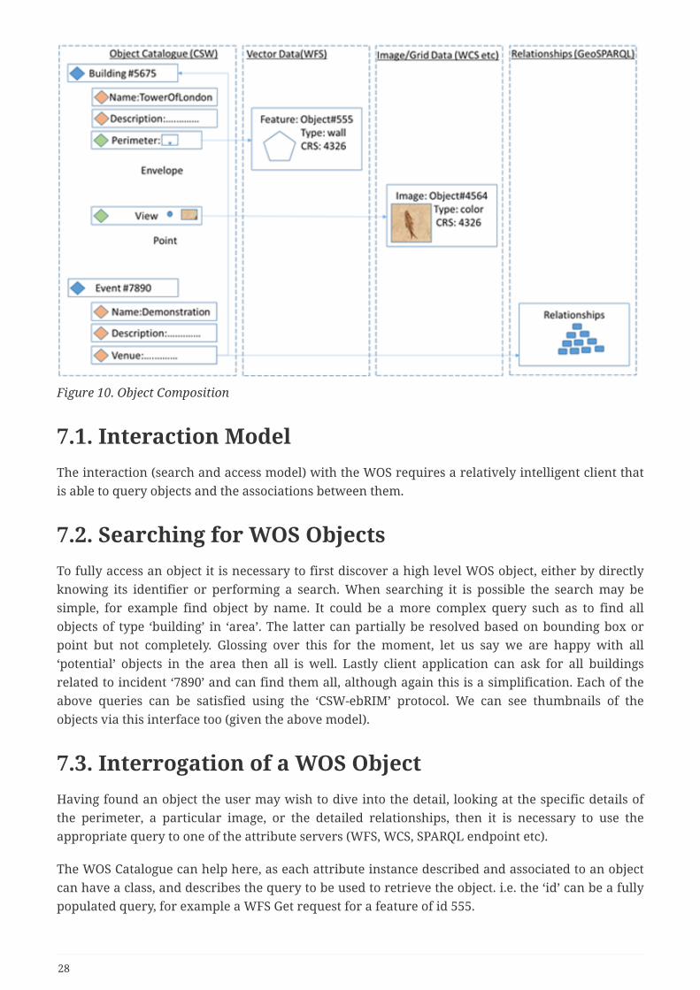
Figure 10. Object Composition
7.1. Interaction ModelThe interaction (search and access model) with the WOS requires a relatively intelligent client thatis able to query objects and the associations between them.
7.2. Searching for WOS ObjectsTo fully access an object it is necessary to first discover a high level WOS object, either by directlyknowing its identifier or performing a search. When searching it is possible the search may besimple, for example find object by name. It could be a more complex query such as to find allobjects of type ‘building’ in ‘area’. The latter can partially be resolved based on bounding box orpoint but not completely. Glossing over this for the moment, let us say we are happy with all‘potential’ objects in the area then all is well. Lastly client application can ask for all buildingsrelated to incident ‘7890’ and can find them all, although again this is a simplification. Each of theabove queries can be satisfied using the ‘CSW-ebRIM’ protocol. We can see thumbnails of theobjects via this interface too (given the above model).
7.3. Interrogation of a WOS ObjectHaving found an object the user may wish to dive into the detail, looking at the specific details ofthe perimeter, a particular image, or the detailed relationships, then it is necessary to use theappropriate query to one of the attribute servers (WFS, WCS, SPARQL endpoint etc).
The WOS Catalogue can help here, as each attribute instance described and associated to an objectcan have a class, and describes the query to be used to retrieve the object. i.e. the ‘id’ can be a fullypopulated query, for example a WFS Get request for a feature of id 555.
28

This model therefore does not necessarily require a client to understand the query model, simply tobe able to execute the query specified. However the return result is of whatever type the servicereturns. In practice the client needs to understand the attribute delivery service for that attributeand decide if it can read that attribute type.
There is an argument that this is more complicated than a single WFS interface, but it is easilyscalable. The WOS Catalogue allows addition of multiple database types, and there is no singlequery interface applicable to all datatypes so this model does offer a highly scalable approach.Testbed-12 demonstrated this capability by allowing a photograph and an audio clip to be servedfrom an Accumulo database as the value of an attribute of an object registered in the WOS.
7.4. Object InsertionThis is to some degree complicated. Firstly attributes can exist in their own right, and so can becreated independently (e.g. Transactional WFS, SPARQL etc). Also WOS objects are easy to createusing an ebRIM Insert transaction. Attributes can also be easily related to a WOS using ebRIM iftheir ID is known (which it will be if they are created by the client, or searched for independently).When creating an attribute reference in an object it is essential that summary metadata is created,for example the extent of the perimeter object (an abstraction of the full geometry) needs to bepopulated to allow spatial searches.
7.5. Update and DeletionWhen an attribute instance is updated, several actions are needed. If the attribute is accessed via aWOS Object, the WOS Object is known and any change to its summary metadata can be enacted.However we have said an attribute can be related to more than one WOS object. One approach is tosearch using an ebRIM query for all attributes with a global id (of the attribute instance) andupdate them all. The alternative is back-pointers but this is likely to get even more unwieldy.Similarly for deletion, if an object is deleted, all references to it need to be deleted. Again theseprocesses put a load on the client, but some automation is ultimately possible.
29
Chapter 8. WFS based Web Object Service
8.1. IntroductionThe Web Object Service (WOS) is a general data access service for objects. It can be considered anextension of a Web Feature Service where the restriction to operate on features has been relaxed.
The general characteristics of a WOS are:
• Provides a service description document (i.e. capabilities) describing:
• the type of service being offered
• information about the service provider
• a set of parameter and service constraints
• the list of object collections offered by the service
• access to general objects (i.e. members of a collection)
• objects can be features
• objects can also be binary objects
• objects can be abstract (e.g. decisions)
• simple query capability
• the ability to dynamically define collections of object using simple predicates (e.g. time,space, taxonomy)
• simple transaction capability
• the ability to create/modify/delete single objects
This clause describes, in general terms, the CubeWerx implementation of a WOS for OGC Testbed12.
8.2. RequirementsThe following set of general requirements were used to drive the design and implementation of theWOS provided by CubeWerx:
1. A WOS can handle any kind of object including binary objects.
2. Objects are exposed through the WOS API using a common query model that includes spatialand/or temporal properties.
3. A WOS can maintain associations between objects under its control and other non-WOSresources
4. Associations can be simple links or they can be considered first class objects with properties.
5. A WOS can classify objects using any number of classification schemes.
30
6. A WOS query can include spatial, non-spatial, temporal and taxonomic predicates
8.3. ArchitectureThe following diagram illustrates the architecture on the CubeWerx WOS implemented for Testbed12:
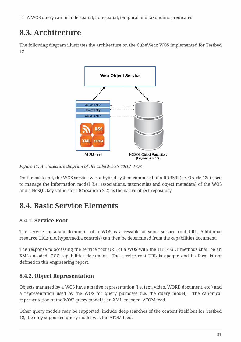
Figure 11. Architecture diagram of the CubeWerx’s TB12 WOS
On the back end, the WOS service was a hybrid system composed of a RDBMS (i.e. Oracle 12c) usedto manage the information model (i.e. associations, taxonomies and object metadata) of the WOSand a NoSQL key-value store (Cassandra 2.2) as the native object repository.
8.4. Basic Service Elements
8.4.1. Service Root
The service metadata document of a WOS is accessible at some service root URL. Additionalresource URLs (i.e. hypermedia controls) can then be determined from the capabilities document.
The response to accessing the service root URL of a WOS with the HTTP GET methods shall be anXML-encoded, OGC capabilities document. The service root URL is opaque and its form is notdefined in this engineering report.
8.4.2. Object Representation
Objects managed by a WOS have a native representation (i.e. text, video, WORD document, etc.) anda representation used by the WOS for query purposes (i.e. the query model). The canonicalrepresentation of the WOS' query model is an XML-encoded, ATOM feed.
Other query models may be supported, include deep-searches of the content itself but for Testbed12, the only supported query model was the ATOM feed.
31

8.4.3. Content Negotiation
Two common approaches for content negotiation are supported by the WOS; HTTP headers (i.e.Accept header) and HTTP query parameters (i.e. outputFormat or f). In any context there must beagreement between content negotiation methods used; otherwise an exception shall be raised(HTTP code=415). Content negotiation using the Accept header shall proceed in the standardmanner describe in the HTTP protocol:
• When submitting an HTTP request to a service, the client shall set the Accept header with a listof desired response content types in order of preference
• The server shall respond with the most preferred content type it supports
• An exception shall be thrown if none of the specified content types are supported
• In any context, the HTTP OPTIONS method may be used to get the list of support content types.(NOTE: this is not implemented for Testbed 12)
Content negotiation using the HTTP query parameters shall proceed in the usual OGC way (i.e. thedesired content type is specified using the output format query parameter and the server eithersupports it or it does not). The list of supported formats for the query model of a WOS shall beadvertised in the server’s capabilities document.
8.4.4. Exceptions
When a service exception occurs, the server shall respond with an appropriate HTTP error code.All exceptions that are the result of an invalid client request should have an HTTP error code in the4xx range (and in most, if not all cases, should specifically be "400 Bad Request"). Server-side issuesshould be given an HTTP error code in the 5xx range (and in most if not all cases) shouldspecifically be "500 Internal Server Error".
The canonical content of an exception shall be an OGC service exception report. This engineeringreport does not define behavior for all HTTP methods for all resource (e.g. the behavior of the PUTmethod is not described for the capabilities resource "/"). When a server is presented with anunsupported HTTP method for a particular resource it shall respond with the HTTP error code "405Method Not Allowed" and should contain an OGC exception message in the body of the response.
NOTE Implementations are free to implement (or not) whatever behavior they want in cases wherebehavior is not defined in this engineering report (e.g. for experimental purposes or vendorextensions) but whatever they do will be outside the scope of this engineering report.
8.5. Authentication and Access ControlAll methods and resource described in the engineering report are subject to authentication andaccess control. It is envisioned that authentication and access control will be layered on top of aRESTful WOS but the description of how that would be done is beyond the scope of this engineeringreport.
NOTE For OGC Testbed 12, the CubeWerx WOS can be protected using HTTP Basic Authentication.
32

8.6. Hypermedia Controls
8.6.1. Introduction
Hypermedia controls are the means by which, at any given state, a server enumerate for clientwhat possible next states are available.
Hypermedia controls defined by a WOS shall be encoded, in XML, as ATOM links. ATOM links aredefined in the following schema:
• http://schemas.opengis.net/kml/2.2.0/atom-author-link.xsd
The canonical value for the rel attribute shall either be:
• a token taken from the IANA Link Relation register (see: http://www.iana.org/assignments/link-relations/link-relations.xhtml)
• or it shall be a URI registered with the OGC Naming Authority
• or it shall be a value defined in this engineering report that shall be submitted to the OGC NAfor registration (eventually)
8.6.2. Hypermedia Control in a WOS' Capabilities Document
The following hypermedia controls shall be included in the capabilities document of a WOS:
• for each offered object collection listed in the capabilities document:
• a link, with rel="collection", shall be included that points to the root URL of the collection
• a server is free to include any other desired hypermedia controls in the server’s capabilitiesdocument
8.6.3. Hypermedia Controls in a WOS' Query Response
The following hypermedia control shall be included in the response to a WOS query:
• the query response element (i.e. ATOM entry) shall contain a link with rel="self" containing theentry’s URL
A server is free to include any other hypermedia controls within an ATOM entry. Some examples ofcommon links that may be used include:
• alternate: pointing to alternate representations of the ATOM entity
• edit: pointing to a location where the entry can be updated or deleted
• next/prev: pointing to a related next or previous object within a chain of resources
8.7. Summary of ResourcesThe following tables summarizes the resources offered by a WOS:
33

Table 2. Summary of WOS resources
ResourceClass
Description Access path
Capabilities The complete service metadatadocument
/
Objectcollection
A collection of objects /{collection name}
Object An object (i.e. a specific member of anamed collection)
/{object URL}
Association A directional relationship betweentwo objects
/associations[/{id}]
ClassificationScheme
A taxonomy /classificationSchemes[/{id}]
ClassificationNode
A node in a taxonomy /classificationNodes[/{id}]
Classification An association between an object anda node in a taxonomy
/classifications[/{id}]
8.8. MIME TypesThe following MIME types are defined by this engineering report:
• Associations document
• encoded as XML: application/ogc-as+xml
• Classification document:
• encoded as XML: application/ogc-cl+xml
8.9. A Word about ExamplesMany of the descriptions in this engineering report are accompanied by examples in the form ofsequence diagrams showing the HTTP interaction between a client and a server. These examplesreference a fictitious service root: http://www.someserver.com/1.0/wos/. The "1.0/wos" componentof the path is the examples is not part of the canonical resource URLs but simply part of thisexample’s service root.
In a number of examples, normally packed text that has been wrapped across multiple lines for thesake of clarity and space.
In many cases, the XML does not contain all the necessary information in order to validate; again,this is done for the sake of clarity.
34
8.10. Service Metadata
8.10.1. Introduction
A WOS' capabilities document includes hypermedia controls to get the URL of each object collectionoffered by the WOS and a URL endpoint that allows objects to be added, modified or removed fromthe collection.
8.10.2. Resources
The base or root URL of a server (path = '/') shall resolve to the service metadata document (a.k.a.the OGC Capabilities document).
8.10.3. Query Parameters
The following table lists the query parameters that may be used with the capabilities resource:
Table 3. Capabilities query parameters
ParameterName
Description
acceptVersions A comma-separated list of acceptable version ordered mostpreferable first.
sections A comma-separated list of section names to be included in acapabilities document. Valid values are: ServiceIdentification,ServiceProvider, OperationsMetadata, ObjectCollections,FilterCapabilities.
acceptFormats A comma-separated list of acceptable formats for thecapabilities document order most preferable first.
8.10.4. Representations
The canonical representation for a service metadata document shall be the XML-encoded OGCcapabilities document as defined in the wos.xsd schema.
NOTEThe wos.xsd schema may be accessed at online athttp://cubewerx.pvretano.com/schemas/wos/1.0.0.
The recommended other output format for a capabilities document is HTML5. The content of theHTML5 version of the capabilities document shall be the same a the XML version. This engineeringreport does not provide a standard definition for a capabilities document expressed in HTML5.Implementations are free to make the HTML5 output look as pretty as they like.
Other representations (e.g. JSON) are allowed but are not described in this engineering report.
35
8.10.5. Methods
The following table describes the actions that server should take when the specified method isapplied to the specified resource. The resources from
Table 4. Methods
Resource
Method Action
/ GET Gets the complete capabilities document
/ POST Not specified by this engineering report.
/ PUT Not specified by this engineering report.
/ DELETE Not specified by this engineering report.
8.10.6. Examples
Example 1: Get the list of object collections offered by a WOS
36

CLIENT SERVER | | | GET /1.0/wos?sections=ObjectCollections HTTP/1.1 | | Host: www.someserver.com | | Accept: text/xml | |---------------------------------------------------------->| | | | HTTP/1.1 200 OK | | Content-Type: text/xml | | | | <?xml version="1.0"?> | | <ObjectCollections...> | | <ObjectCollection> | | <atom:link rel="collection" | | type="application/atom+xml" | | href="http://www.someserver.com/wos/1.0/objects"/> | <atom:link rel="edit" | | href="http://www.someserver.com/wos/1.0/objects"/> | <Name>Objects</Name> | | <Title>The Default Object Collection</Title> | | <Abstract>This is the default collection used by the WOS to manageobjects</Abstract> | <ows:Keywords> | | <ows:Keyword>WOS</ows:Keyword> | | <ows:Keyword>web</ows:Keyword> | | <ows:Keyword>object</ows:Keyword> | | <ows:Keyword>service</ows:Keyword> | | </ows:Keywords> | | <DefaultCRS>urn:ogc:def:crs:EPSG::6269</DefaultCRS> | <OtherCRS>urn:ogc:def:crs:EPSG::32615</OtherCRS> | | <OtherCRS>urn:ogc:def:crs:EPSG::32616</OtherCRS> | | <OtherCRS>urn:ogc:def:crs:EPSG::32617</OtherCRS> | | <OtherCRS>urn:ogc:def:crs:EPSG::32618</OtherCRS> | | <ows:WGS84BoundingBox> | | <ows:LowerCorner>-180 -90</ows:LowerCorner> | | <ows:UpperCorner>180 90</ows:UpperCorner> | | </ows:WGS84BoundingBox> | | </ObjectCollection> | | </ObjectCollections> | |<----------------------------------------------------------|
Example 2: Get the complete capabilities document
CLIENT SERVER | | | GET /wos/1.0 HTTP/1.1 | | Host: www.someserver.com | | Accept: text/xml | |---------------------------------------------------------->|
37
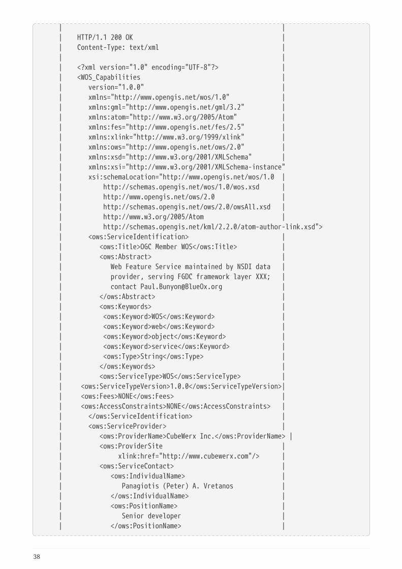
| | | HTTP/1.1 200 OK | | Content-Type: text/xml | | | | <?xml version="1.0" encoding="UTF-8"?> | | <WOS_Capabilities | | version="1.0.0" | | xmlns="http://www.opengis.net/wos/1.0" | | xmlns:gml="http://www.opengis.net/gml/3.2" | | xmlns:atom="http://www.w3.org/2005/Atom" | | xmlns:fes="http://www.opengis.net/fes/2.5" | | xmlns:xlink="http://www.w3.org/1999/xlink" | | xmlns:ows="http://www.opengis.net/ows/2.0" | | xmlns:xsd="http://www.w3.org/2001/XMLSchema" | | xmlns:xsi="http://www.w3.org/2001/XMLSchema-instance" | xsi:schemaLocation="http://www.opengis.net/wos/1.0 | | http://schemas.opengis.net/wos/1.0/wos.xsd | | http://www.opengis.net/ows/2.0 | | http://schemas.opengis.net/ows/2.0/owsAll.xsd | | http://www.w3.org/2005/Atom | | http://schemas.opengis.net/kml/2.2.0/atom-author-link.xsd"> | <ows:ServiceIdentification> | | <ows:Title>OGC Member WOS</ows:Title> | | <ows:Abstract> | | Web Feature Service maintained by NSDI data | | provider, serving FGDC framework layer XXX; | | contact [email protected] | | </ows:Abstract> | | <ows:Keywords> | | <ows:Keyword>WOS</ows:Keyword> | | <ows:Keyword>web</ows:Keyword> | | <ows:Keyword>object</ows:Keyword> | | <ows:Keyword>service</ows:Keyword> | | <ows:Type>String</ows:Type> | | </ows:Keywords> | | <ows:ServiceType>WOS</ows:ServiceType> | | <ows:ServiceTypeVersion>1.0.0</ows:ServiceTypeVersion>| | <ows:Fees>NONE</ows:Fees> | | <ows:AccessConstraints>NONE</ows:AccessConstraints> | | </ows:ServiceIdentification> | | <ows:ServiceProvider> | | <ows:ProviderName>CubeWerx Inc.</ows:ProviderName> | | <ows:ProviderSite | | xlink:href="http://www.cubewerx.com"/> | | <ows:ServiceContact> | | <ows:IndividualName> | | Panagiotis (Peter) A. Vretanos | | </ows:IndividualName> | | <ows:PositionName> | | Senior developer | | </ows:PositionName> |
38
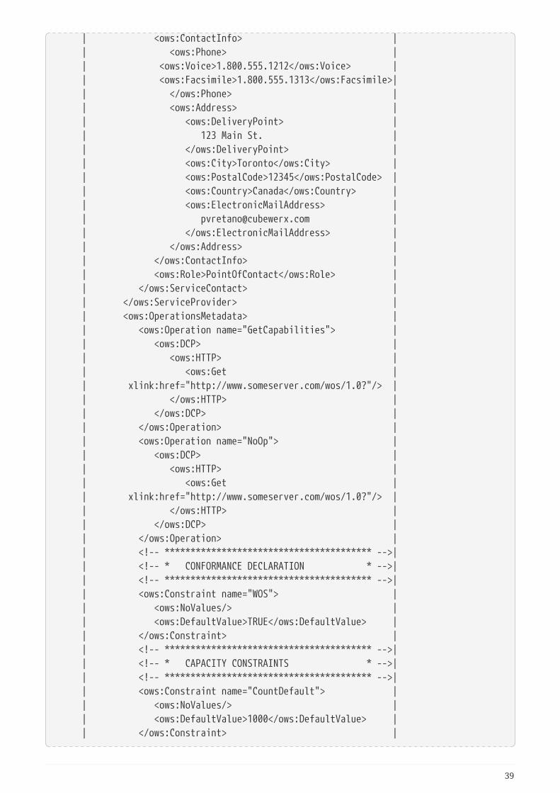
| <ows:ContactInfo> | | <ows:Phone> | | <ows:Voice>1.800.555.1212</ows:Voice> | | <ows:Facsimile>1.800.555.1313</ows:Facsimile>| | </ows:Phone> | | <ows:Address> | | <ows:DeliveryPoint> | | 123 Main St. | | </ows:DeliveryPoint> | | <ows:City>Toronto</ows:City> | | <ows:PostalCode>12345</ows:PostalCode> | | <ows:Country>Canada</ows:Country> | | <ows:ElectronicMailAddress> | | [email protected] | | </ows:ElectronicMailAddress> | | </ows:Address> | | </ows:ContactInfo> | | <ows:Role>PointOfContact</ows:Role> | | </ows:ServiceContact> | | </ows:ServiceProvider> | | <ows:OperationsMetadata> | | <ows:Operation name="GetCapabilities"> | | <ows:DCP> | | <ows:HTTP> | | <ows:Get | | xlink:href="http://www.someserver.com/wos/1.0?"/> | | </ows:HTTP> | | </ows:DCP> | | </ows:Operation> | | <ows:Operation name="NoOp"> | | <ows:DCP> | | <ows:HTTP> | | <ows:Get | | xlink:href="http://www.someserver.com/wos/1.0?"/> | | </ows:HTTP> | | </ows:DCP> | | </ows:Operation> | | <!-- **************************************** -->| | <!-- * CONFORMANCE DECLARATION * -->| | <!-- **************************************** -->| | <ows:Constraint name="WOS"> | | <ows:NoValues/> | | <ows:DefaultValue>TRUE</ows:DefaultValue> | | </ows:Constraint> | | <!-- **************************************** -->| | <!-- * CAPACITY CONSTRAINTS * -->| | <!-- **************************************** -->| | <ows:Constraint name="CountDefault"> | | <ows:NoValues/> | | <ows:DefaultValue>1000</ows:DefaultValue> | | </ows:Constraint> |
39
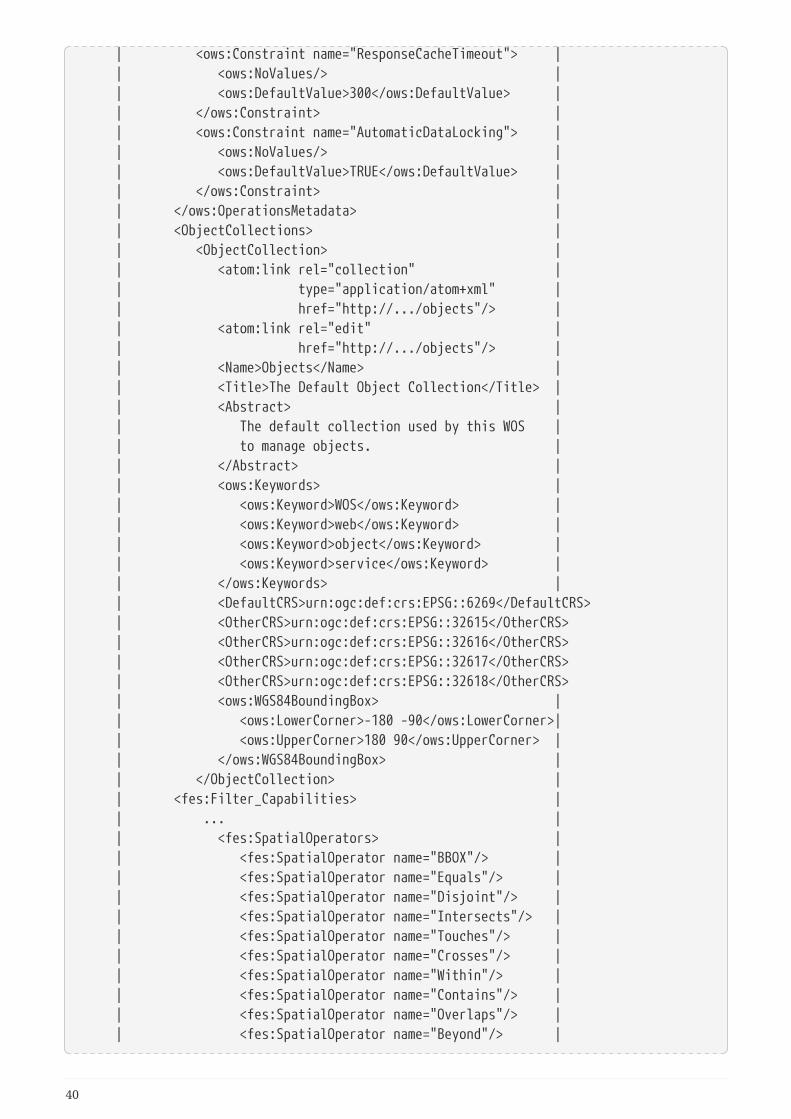
| <ows:Constraint name="ResponseCacheTimeout"> | | <ows:NoValues/> | | <ows:DefaultValue>300</ows:DefaultValue> | | </ows:Constraint> | | <ows:Constraint name="AutomaticDataLocking"> | | <ows:NoValues/> | | <ows:DefaultValue>TRUE</ows:DefaultValue> | | </ows:Constraint> | | </ows:OperationsMetadata> | | <ObjectCollections> | | <ObjectCollection> | | <atom:link rel="collection" | | type="application/atom+xml" | | href="http://.../objects"/> | | <atom:link rel="edit" | | href="http://.../objects"/> | | <Name>Objects</Name> | | <Title>The Default Object Collection</Title> | | <Abstract> | | The default collection used by this WOS | | to manage objects. | | </Abstract> | | <ows:Keywords> | | <ows:Keyword>WOS</ows:Keyword> | | <ows:Keyword>web</ows:Keyword> | | <ows:Keyword>object</ows:Keyword> | | <ows:Keyword>service</ows:Keyword> | | </ows:Keywords> | | <DefaultCRS>urn:ogc:def:crs:EPSG::6269</DefaultCRS> | <OtherCRS>urn:ogc:def:crs:EPSG::32615</OtherCRS> | <OtherCRS>urn:ogc:def:crs:EPSG::32616</OtherCRS> | <OtherCRS>urn:ogc:def:crs:EPSG::32617</OtherCRS> | <OtherCRS>urn:ogc:def:crs:EPSG::32618</OtherCRS> | <ows:WGS84BoundingBox> | | <ows:LowerCorner>-180 -90</ows:LowerCorner>| | <ows:UpperCorner>180 90</ows:UpperCorner> | | </ows:WGS84BoundingBox> | | </ObjectCollection> | | <fes:Filter_Capabilities> | | ... | | <fes:SpatialOperators> | | <fes:SpatialOperator name="BBOX"/> | | <fes:SpatialOperator name="Equals"/> | | <fes:SpatialOperator name="Disjoint"/> | | <fes:SpatialOperator name="Intersects"/> | | <fes:SpatialOperator name="Touches"/> | | <fes:SpatialOperator name="Crosses"/> | | <fes:SpatialOperator name="Within"/> | | <fes:SpatialOperator name="Contains"/> | | <fes:SpatialOperator name="Overlaps"/> | | <fes:SpatialOperator name="Beyond"/> |
40
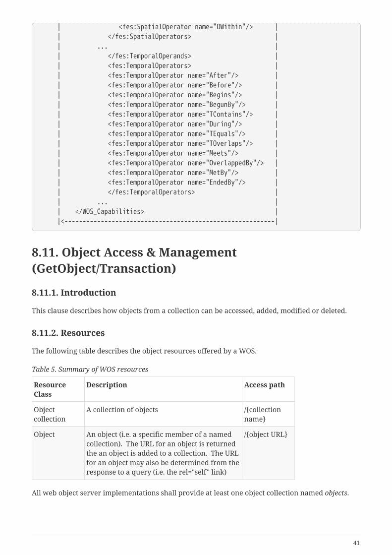
| <fes:SpatialOperator name="DWithin"/> | | </fes:SpatialOperators> | | ... | | </fes:TemporalOperands> | | <fes:TemporalOperators> | | <fes:TemporalOperator name="After"/> | | <fes:TemporalOperator name="Before"/> | | <fes:TemporalOperator name="Begins"/> | | <fes:TemporalOperator name="BegunBy"/> | | <fes:TemporalOperator name="TContains"/> | | <fes:TemporalOperator name="During"/> | | <fes:TemporalOperator name="TEquals"/> | | <fes:TemporalOperator name="TOverlaps"/> | | <fes:TemporalOperator name="Meets"/> | | <fes:TemporalOperator name="OverlappedBy"/> | | <fes:TemporalOperator name="MetBy"/> | | <fes:TemporalOperator name="EndedBy"/> | | </fes:TemporalOperators> | | ... | | </WOS_Capabilities> | |<----------------------------------------------------------|
8.11. Object Access & Management(GetObject/Transaction)
8.11.1. Introduction
This clause describes how objects from a collection can be accessed, added, modified or deleted.
8.11.2. Resources
The following table describes the object resources offered by a WOS.
Table 5. Summary of WOS resources
ResourceClass
Description Access path
Objectcollection
A collection of objects /{collectionname}
Object An object (i.e. a specific member of a namedcollection). The URL for an object is returnedthe an object is added to a collection. The URLfor an object may also be determined from theresponse to a query (i.e. the rel="self" link)
/{object URL}
All web object server implementations shall provide at least one object collection named objects.
41

8.11.3. Query parameters
Query parameters may be appended to an object URL to control the output format and content of aquery response and identify a subset of objects from a collection. The following table defines thequery parameters that may be appended to an object URL.
Table 6. Object query parameters
Parameter Description
outputFormat Specifies the representation of the query response
count Specifies the number of objects to present in the queryresponse
startIndex Specifies the starting point from which objects are presentedin the query response
namespaces Used to declare the namespaces for qualified names
srsName The CRS to be used when presenting geometric values in thequery response
filterLanguage Specifies the language used to define a filter
filter Specifies a query filter in the language specified using thefilterLanguage parameter
bbox Specifies a bounding box predicate
geometry A WKT-encoded geometry
crs The coordinate reference system for the value of the geometryparameter
spatialOp The spatial operation to use for testing the geometry of anobject against the value of the geometry parameter. Validvalues are: Equals, Disjoint, Touches, Withing, Overlaps,Crosses, Intersects (default), Contains
time An ISO8601 time instance or interval
temporalOp The temporal operator to apply when comparing an objectstemporal property with the value of the time parameter. Validvalues are: After, Before, Begins, During (default), EndedBy,Ends, TEquals, Meets, MetBy
classifiedAs The identifier of a node within a classification scheme
classificationScope
One of narrow, exact or board
8.11.4. Representations
Each object managed by the WOS has two representations; a native representation and acorresponding ATOM representation used as the query model by the WOS.
The native representation is whatever representation is presented to the WOS when the object is
42
created (e.g. video format, image, MSWORD document, etc.). The native representation is stored andcan be retrieved with full fidelity.
The canonical representation for the object’s query model is the ATOM entry as described in RFC5023. When querying a WOS, it is this representation that is queried to identify the set of objectsthat satisfy the query predicate.
8.11.5. Methods
The following table describes the actions the server should take when the specified method isapplied to the specified resource.
Table 7. Methods
Resource Method Action
/{collectionname}
GET Get a subset of objects from the specified objectcollection. The number of objects returneddepends on the value of the count queryparameter.
POST Adds a new member to the object collection. Arepresentation of the object is supplied as thebody of the request.
PUT Replaces one or more objects in the specifiedcollection. A representation of the new object issupplied in the body of the request.
DELETE Deletes one or more objects from the specifiedcollection
/{object URL} GET Gets the specified object.
POST Not specified by this engineering report.
PUT Replaces the specified object. A representation ofthe replacement object is supplied om the body ofthe request.
DELETE Deletes all representations of the specified object
As previously mentioned each object managed by the WOS has its native representation and acorresponding representation that is used as the query model (i.e. an ATOM entry). A new objectcan be added to a collection in one of three ways.
• An ATOM entry is POSTed to the WOS that encodes the object in-line as a base64 string
• An ATOM entry is POSTed to the WOS and then that entry is subsequently updated, using theHTTP PUT method, to add the native representation of the object
• The native representation of the object is POSTed to WOS which stores that object and creates aminimal corresponding ATOM entry for the object to be used as the query model. This minimalATOM entry may be subsequently updated, using the HTTP PUT method, to enrich its content.
43

8.11.6. Examples:
Example 1: Get a subset of objects from a collection
44

CLIENT SERVER | | | GET /1.0/wos/object?count=27 HTTP/1.1 | | Host: www.someserver.com | | Accept: application/atom+xml | |---------------------------------------------------------->| | | | HTTP/1.1 200 OK | | Content-Type: application/atom+xml | | | | <?xml version="1.0"?> | | <feed xmlns="http://www.w3.org/2005/Atom" | | xmlns:georss="http://www.georss.org/georss" | | xmlns:gml="http://www.opengis.net/gml" | | xmlns:cw="http://www.cubewerx.com/cw"> | | <title>Web Object Server Default Collection</title> | | <link rel="self" | | href="http://www.someserver.com/.../objects"/> | | <updated>2016-07-30T03:18:16Z</updated> | | <subtitle>This is the default collection that the Web| | Object Service uses for managing objects. Specific | | deployments of the server many have other object | | collections as well.</subtitle> | | <id>urn:uuid:2e2c23df-a8db-4318-b52a-8b8efffcbb74</id> | <generator uri="http://www.someserver.com/..."/> | | CubeWerx Web Object Service</generator> | | <entry cw:id="CWFID.OBJECTS.0.0"> | | <author> | | <name>Panagiotis Vretanos</name> | | <email>[email protected]</email> | | </author> | | <content type="text/plain">Just some dummy content</content> | <id>urn:uuid:ce28abbe-d17e-426d-8dae-a7977442a7be</id> | <link href="http://www.someserver.com/..." | | type="video/mp4" rel="alternate"/> | | <link href="http://www.someserver.com/.../objects/CWFID.OBJECTS.0.0" | type="application/atom+xml" rel="self"/> | | <summary>Example dummy object</summary> | | <title>Update an object</title> | | <updated>20110118011435</updated> | | <georss:where> | | <gml:Point> | | <gml:pos>44.176426731297 -71.422232532932</gml:pos> | </gml:Point> | | </georss:where> | | </entry> | | </feed> | |<----------------------------------------------------------|
45

NOTEThe ATOM entry in this example includes a link with rel="alternate" that may beused to retrieve the native representation of the object.
Example 2: Get the subset of objects that lie within a specified bounding box.
CLIENT SERVER | | | GET /1.0/wos/objects?bbox=10,10,20,20 HTTP/1.1 | | Host: www.someserver.com | | Accept: application/atom+xml | |---------------------------------------------------------->| | | | HTTP/1.1 200 OK | | Content-Type: application/atom+xml | | | | <?xml version="1.0"?> | | <feed> ... </feed> | |<----------------------------------------------------------|
Example 3: Add a new object to a collection.
Step 1: Create the ATOM entry for the object.
CLIENT SERVER | | | POST /1.0/wos/objects HTTP/1.1 | | Host: www.someserver.com | | Content-Type: application/atom+xml | | | | <?xml version="1.0"?> | | <entry> | | . | | . An ATOM entry describing the object... | | . | | <georss:where> | | <gml:Point> | | <gml:pos>44.176426731297 -71.422232532932</gml:pos> | </gml:Point> | | </georss:where> | | </entry> | |---------------------------------------------------------->| | | | HTTP/1.1 201 Created | | Location: /1.0/wos/object/1014 | |<----------------------------------------------------------|
46
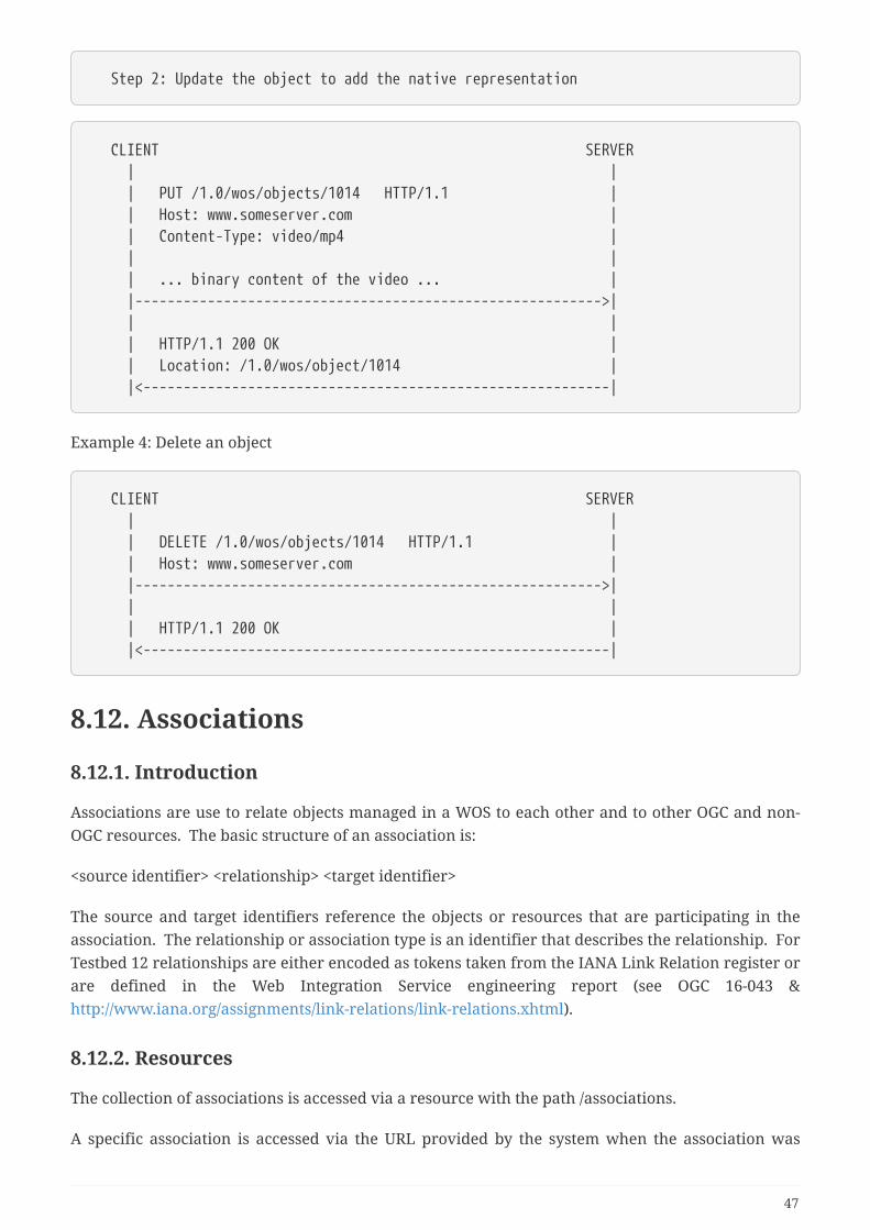
Step 2: Update the object to add the native representation
CLIENT SERVER | | | PUT /1.0/wos/objects/1014 HTTP/1.1 | | Host: www.someserver.com | | Content-Type: video/mp4 | | | | ... binary content of the video ... | |---------------------------------------------------------->| | | | HTTP/1.1 200 OK | | Location: /1.0/wos/object/1014 | |<----------------------------------------------------------|
Example 4: Delete an object
CLIENT SERVER | | | DELETE /1.0/wos/objects/1014 HTTP/1.1 | | Host: www.someserver.com | |---------------------------------------------------------->| | | | HTTP/1.1 200 OK | |<----------------------------------------------------------|
8.12. Associations
8.12.1. Introduction
Associations are use to relate objects managed in a WOS to each other and to other OGC and non-OGC resources. The basic structure of an association is:
<source identifier> <relationship> <target identifier>
The source and target identifiers reference the objects or resources that are participating in theassociation. The relationship or association type is an identifier that describes the relationship. ForTestbed 12 relationships are either encoded as tokens taken from the IANA Link Relation register orare defined in the Web Integration Service engineering report (see OGC 16-043 &http://www.iana.org/assignments/link-relations/link-relations.xhtml).
8.12.2. Resources
The collection of associations is accessed via a resource with the path /associations.
A specific association is accessed via the URL provided by the system when the association was
47
created. This URL is normally opaque but in the case of CubeWerx’s TB12 WOS, the URL templatefor an association is /associations/{id}.
Query Parameters
The following table summarizes the query parameters that may be used with the /associationsresource. These intent of these parameters is to provide a simple query API for associations. Thevalues specified for these parameters are logically combined using the AND operation to form aquery predicate for selecting which associations should be presented in a response document.
Table 8. Object query parameters
Parameter Description
outputFormat Specifies the output representation of an association
id The identifier for a specific association
rel A relationship identifier (i.e. IANA token or OGCURN/URL)
sourceId A source identifier or base URL of an OGC service
localSourceId The local identifier for a source OGC resource
sourceType The source object type
targetId A target identifier or base URL of an OGC service
localTargetId The local identifier for a target OGC resource
targetType The target object type
Representations
The following XML schema fragment defines the XML-encoding for an Association and a collectionof associations.
48
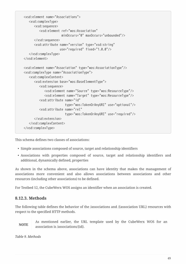
<xsd:element name="Associations"> <xsd:complexType> <xsd:sequence> <xsd:element ref="wos:Association" minOccurs="0" maxOccurs="unbounded"/> </xsd:sequence> <xsd:attribute name="version" type="xsd:string" use="required" fixed="1.0.0"/> </xsd:complexType> </xsd:element>
<xsd:element name="Association" type="wos:AssociationType"/> <xsd:complexType name="AssociationType"> <xsd:complexContent> <xsd:extension base="wos:BaseElementType"> <xsd:sequence> <xsd:element name="Source" type="wos:ResourceType"/> <xsd:element name="Target" type="wos:ResourceType"/> <xsd:attribute name="id" type="wos:TokenOrAnyURI" use="optional"/> <xsd:attribute name="rel" type="wos:TokenOrAnyURI" use="required"/> </xsd:extension> </xsd:complexContent> </xsd:complexType>
This schema defines two classes of associations:
• Simple associations composed of source, target and relationship identifiers
• Associations with properties composed of source, target and relationship identifiers andadditional, dynamically defined, properties
As shown in the schema above, associations can have identity that makes the management ofassociations more convenient and also allows associations between associations and otherresources (including other associations) to be defined.
For Testbed 12, the CubeWerx WOS assigns an identifier when an association is created.
8.12.3. Methods
The following table defines the behavior of the /associations and /{association URL} resources withrespect to the specified HTTP methods.
NOTEAs mentioned earlier, the URL template used by the CubeWerx WOS for anassociation is /associations/{id}.
Table 9. Methods
49
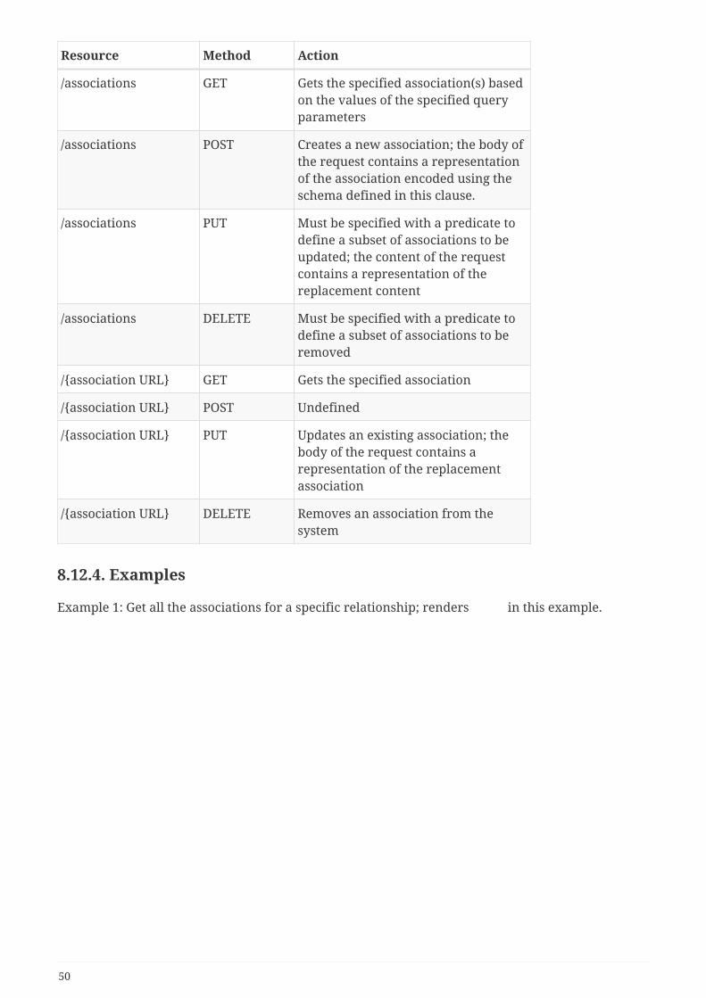
Resource Method Action
/associations GET Gets the specified association(s) basedon the values of the specified queryparameters
/associations POST Creates a new association; the body ofthe request contains a representationof the association encoded using theschema defined in this clause.
/associations PUT Must be specified with a predicate todefine a subset of associations to beupdated; the content of the requestcontains a representation of thereplacement content
/associations DELETE Must be specified with a predicate todefine a subset of associations to beremoved
/{association URL} GET Gets the specified association
/{association URL} POST Undefined
/{association URL} PUT Updates an existing association; thebody of the request contains arepresentation of the replacementassociation
/{association URL} DELETE Removes an association from thesystem
8.12.4. Examples
Example 1: Get all the associations for a specific relationship; renders in this example.
50
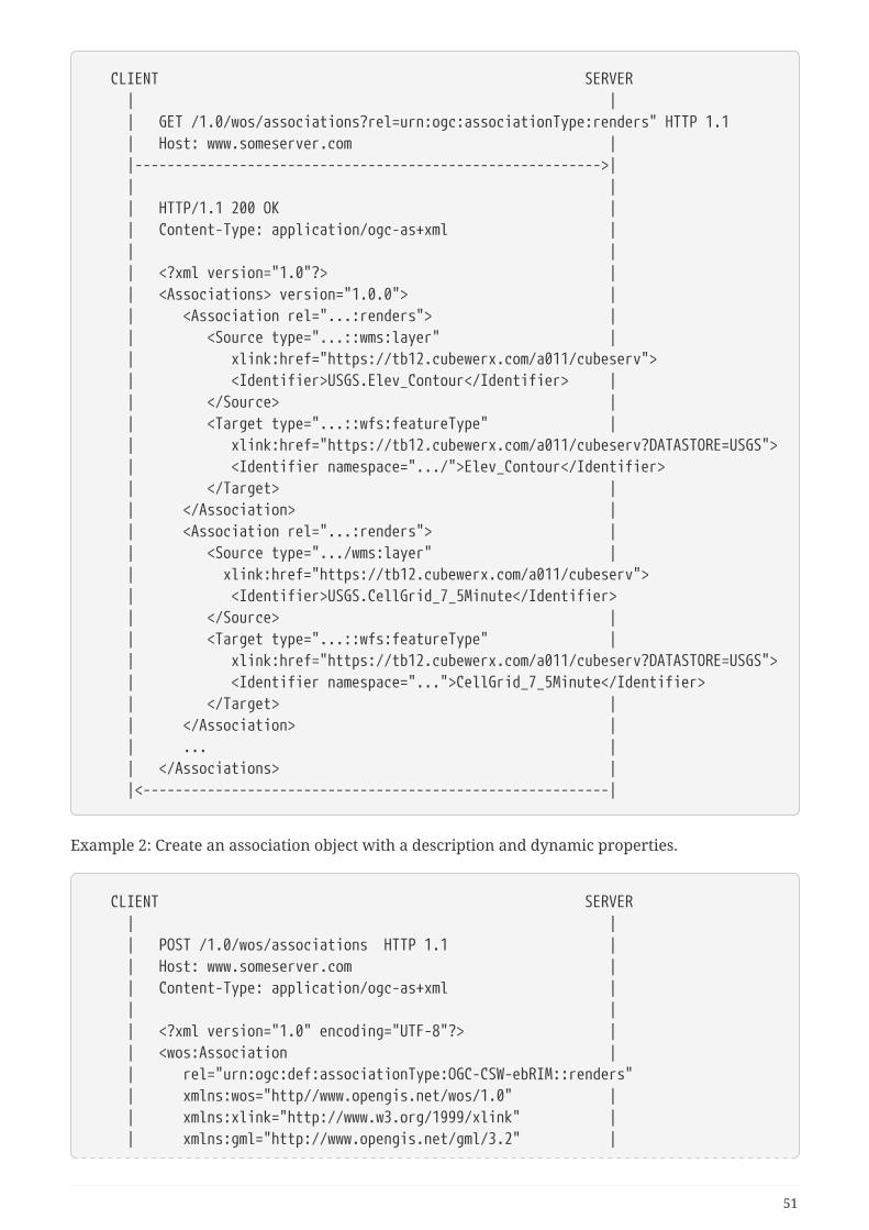
CLIENT SERVER | | | GET /1.0/wos/associations?rel=urn:ogc:associationType:renders" HTTP 1.1 | Host: www.someserver.com | |---------------------------------------------------------->| | | | HTTP/1.1 200 OK | | Content-Type: application/ogc-as+xml | | | | <?xml version="1.0"?> | | <Associations> version="1.0.0"> | | <Association rel="...:renders"> | | <Source type="...::wms:layer" | | xlink:href="https://tb12.cubewerx.com/a011/cubeserv"> | <Identifier>USGS.Elev_Contour</Identifier> | | </Source> | | <Target type="...::wfs:featureType" | | xlink:href="https://tb12.cubewerx.com/a011/cubeserv?DATASTORE=USGS"> | <Identifier namespace=".../">Elev_Contour</Identifier> | </Target> | | </Association> | | <Association rel="...:renders"> | | <Source type=".../wms:layer" | | xlink:href="https://tb12.cubewerx.com/a011/cubeserv"> | <Identifier>USGS.CellGrid_7_5Minute</Identifier> | </Source> | | <Target type="...::wfs:featureType" | | xlink:href="https://tb12.cubewerx.com/a011/cubeserv?DATASTORE=USGS"> | <Identifier namespace="...">CellGrid_7_5Minute</Identifier> | </Target> | | </Association> | | ... | | </Associations> | |<----------------------------------------------------------|
Example 2: Create an association object with a description and dynamic properties.
CLIENT SERVER | | | POST /1.0/wos/associations HTTP 1.1 | | Host: www.someserver.com | | Content-Type: application/ogc-as+xml | | | | <?xml version="1.0" encoding="UTF-8"?> | | <wos:Association | | rel="urn:ogc:def:associationType:OGC-CSW-ebRIM::renders" | xmlns:wos="http//www.opengis.net/wos/1.0" | | xmlns:xlink="http://www.w3.org/1999/xlink" | | xmlns:gml="http://www.opengis.net/gml/3.2" |
51
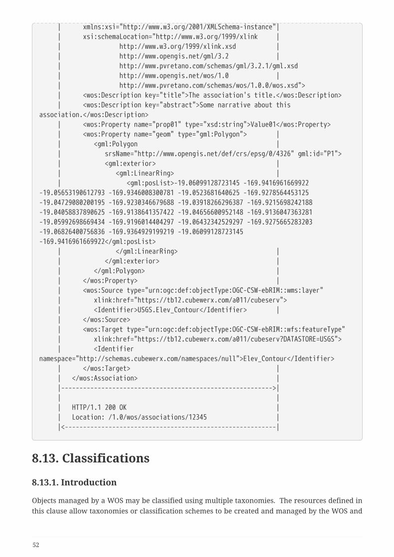
| xmlns:xsi="http://www.w3.org/2001/XMLSchema-instance"| | xsi:schemaLocation="http://www.w3.org/1999/xlink | | http://www.w3.org/1999/xlink.xsd | | http://www.opengis.net/gml/3.2 | | http://www.pvretano.com/schemas/gml/3.2.1/gml.xsd | http://www.opengis.net/wos/1.0 | | http://www.pvretano.com/schemas/wos/1.0.0/wos.xsd"> | <wos:Description key="title">The association's title.</wos:Description> | <wos:Description key="abstract">Some narrative about thisassociation.</wos:Description> | <wos:Property name="prop01" type="xsd:string">Value01</wos:Property> | <wos:Property name="geom" type="gml:Polygon"> | | <gml:Polygon | | srsName="http://www.opengis.net/def/crs/epsg/0/4326" gml:id="P1"> | <gml:exterior> | | <gml:LinearRing> | | <gml:posList>-19.06099128723145 -169.9416961669922-19.05653190612793 -169.9346008300781 -19.0523681640625 -169.9278564453125-19.04729080200195 -169.9230346679688 -19.03918266296387 -169.9215698242188-19.04058837890625 -169.9138641357422 -19.04656600952148 -169.9136047363281-19.05992698669434 -169.9196014404297 -19.06432342529297 -169.9275665283203-19.06826400756836 -169.9364929199219 -19.06099128723145-169.9416961669922</gml:posList> | </gml:LinearRing> | | </gml:exterior> | | </gml:Polygon> | | </wos:Property> | | <wos:Source type="urn:ogc:def:objectType:OGC-CSW-ebRIM::wms:layer" | xlink:href="https://tb12.cubewerx.com/a011/cubeserv"> | <Identifier>USGS.Elev_Contour</Identifier> | | </wos:Source> | <wos:Target type="urn:ogc:def:objectType:OGC-CSW-ebRIM::wfs:featureType" | xlink:href="https://tb12.cubewerx.com/a011/cubeserv?DATASTORE=USGS"> | <Identifiernamespace="http://schemas.cubewerx.com/namespaces/null">Elev_Contour</Identifier> | </wos:Target> | | </wos:Association> | |---------------------------------------------------------->| | | | HTTP/1.1 200 OK | | Location: /1.0/wos/associations/12345 | |<----------------------------------------------------------|
8.13. Classifications
8.13.1. Introduction
Objects managed by a WOS may be classified using multiple taxonomies. The resources defined inthis clause allow taxonomies or classification schemes to be created and managed by the WOS and
52

also allow objects to be tagged with nodes from those classifications schemes thus supportingtaxonomic queries.
NOTENo support for taxonomies was implemented in CubeWerx’s TB12 WOS because theproposed demo scenario was primarily focus on general objects and associations.
8.13.2. Resources
This engineering report defines the following resources to support the management and use oftaxonomies:
• /classificationSchemes
• /{classification scheme URL}
• /classificationNodes
• /{classification node URL}
• /classifications
• /{classification URL}
NOTE
The classification scheme, classification node and classification URLs are opaquebut for testbed 12, CubeWerx’s WOS used the following URL templates for theseresources: /classificationSchemes/{id}, /classificationNodex/{id} and/classifications/{id}.
Query parameters
The following table summarizes the query parameters that may be used with the//classificationSchemes, /classificationNodes and /classifications resources.
Table 10. Object query parameters
Parameter Description
outputFormat Specifies the output representation for thecorresponding resource
id a comma-separated list of identifiers
NOTEThe outputFormat query parameter may also be employed with the /{classificationscheme URL}, /{classification node URL} and /{classification URL} resources.
Representations
Classification Schemes
The following XML schema fragment defines the XML-encoding for a classification schemes ortaxonomies:
53
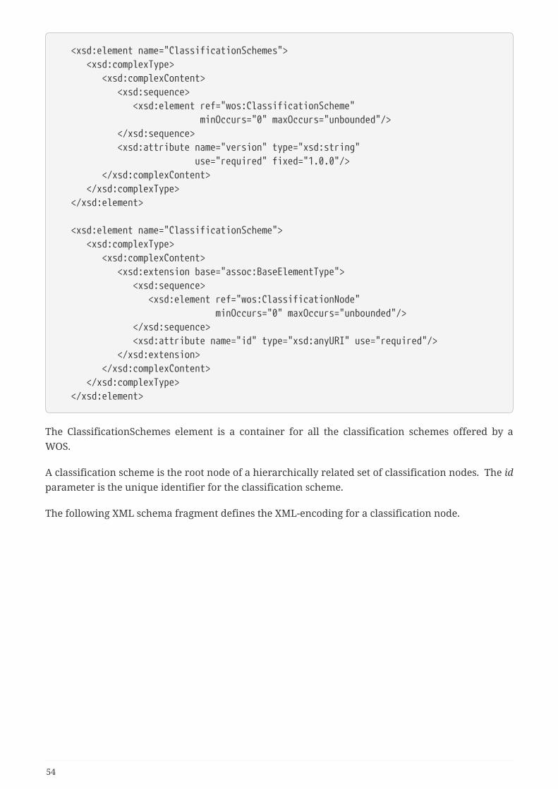
<xsd:element name="ClassificationSchemes"> <xsd:complexType> <xsd:complexContent> <xsd:sequence> <xsd:element ref="wos:ClassificationScheme" minOccurs="0" maxOccurs="unbounded"/> </xsd:sequence> <xsd:attribute name="version" type="xsd:string" use="required" fixed="1.0.0"/> </xsd:complexContent> </xsd:complexType> </xsd:element>
<xsd:element name="ClassificationScheme"> <xsd:complexType> <xsd:complexContent> <xsd:extension base="assoc:BaseElementType"> <xsd:sequence> <xsd:element ref="wos:ClassificationNode" minOccurs="0" maxOccurs="unbounded"/> </xsd:sequence> <xsd:attribute name="id" type="xsd:anyURI" use="required"/> </xsd:extension> </xsd:complexContent> </xsd:complexType> </xsd:element>
The ClassificationSchemes element is a container for all the classification schemes offered by aWOS.
A classification scheme is the root node of a hierarchically related set of classification nodes. The idparameter is the unique identifier for the classification scheme.
The following XML schema fragment defines the XML-encoding for a classification node.
54
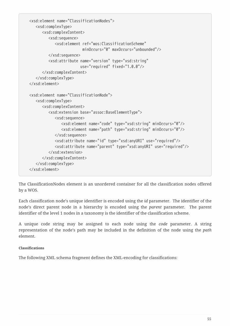
<xsd:element name="ClassificationNodes"> <xsd:complexType> <xsd:complexContent> <xsd:sequence> <xsd:element ref="wos:ClassificationScheme" minOccurs="0" maxOccurs="unbounded"/> </xsd:sequence> <xsd:attribute name="version" type="xsd:string" use="required" fixed="1.0.0"/> </xsd:complexContent> </xsd:complexType> </xsd:element>
<xsd:element name="ClassificationNode"> <xsd:complexType> <xsd:complexContent> <xsd:extension base="assoc:BaseElementType"> <xsd:sequence> <xsd:element name="code" type="xsd:string" minOccurs="0"/> <xsd:element name="path" type="xsd:string" minOccurs="0"/> </xsd:sequence> <xsd:attribute name="id" type="xsd:anyURI" use="required"/> <xsd:attribute name="parent" type="xsd:anyURI" use="required"/> </xsd:extension> </xsd:complexContent> </xsd:complexType> </xsd:element>
The ClassificationNodes element is an unordered container for all the classification nodes offeredby a WOS.
Each classification node’s unique identifier is encoded using the id parameter. The identifier of thenode’s direct parent node in a hierarchy is encoded using the parent parameter. The parentidentifier of the level 1 nodes in a taxonomy is the identifier of the classification scheme.
A unique code string may be assigned to each node using the code parameter. A stringrepresentation of the node’s path may be included in the definition of the node using the pathelement.
Classifications
The following XML schema fragment defines the XML-encoding for classifications:
55
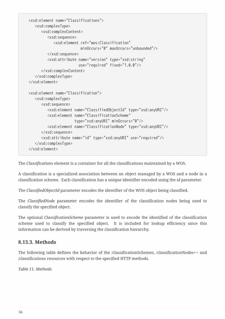
<xsd:element name="Classifications"> <xsd:complexType> <xsd:complexContent> <xsd:sequence> <xsd:element ref="wos:Classification" minOccurs="0" maxOccurs="unbounded"/> </xsd:sequence> <xsd:attribute name="version" type="xsd:string" use="required" fixed="1.0.0"/> </xsd:complexContent> </xsd:complexType> </xsd:element>
<xsd:element name="Classification"> <xsd:complexType> <xsd:sequence> <xsd:element name="ClassifiedObjectId" type="xsd:anyURI"/> <xsd:element name="ClassificationScheme" type="xsd:anyURI" minOccurs="0"/> <xsd:element name="ClassificationNode" type="xsd:anyURI"/> </xsd:sequence> <xsd:attribute name="id" type="xsd:anyURI" use="required"/> </xsd:complexType> </xsd:element>
The Classifications element is a container for all the classifications maintained by a WOS.
A classification is a specialized association between an object managed by a WOS and a node in aclassification scheme. Each classification has a unique identifier encoded using the id parameter.
The ClassifiedObjectId parameter encodes the identifier of the WOS object being classified.
The ClassifiedNode parameter encodes the identifier of the classification nodes being used toclassify the specified object.
The optional ClassificationScheme parameter is used to encode the identified of the classificationscheme used to classify the specified object. It is included for lookup efficiency since thisinformation can be derived by traversing the classification hierarchy.
8.13.3. Methods
The following table defines the behavior of the /classificationSchemes, /classificationNodes++ and/classifications resources with respect to the specified HTTP methods.
Table 11. Methods
56

Resource Method
Action
/classificationSchemes GET With an id query parameter, retrievesclassification schemes with the specifiedidentifiers; otherwise retrieves all theclassification schemes offered by a WOS
/classificationSchemes POST Creates a new classification scheme; the bodyof the request shall contain a representation ofa classificationScheme
/classificationSchemes PUT An id query parameter must be specifiedenumerating a subset of classification schemesto be updated; the body of the request shallcontain a representation of the replacementclassificationScheme
/classificationSchemes DELETE
Ad id query parameter must be specifiedenumeration a subset of classification schemeto be deleted; all non-shared classificationnodes and classifications using this taxonomyshall be deleted as well
/classificationNodes GET With an id query parameter, retrievesclassification nodes with the specifiedidentifiers; otherwise retrieves all theclassification node offered by a WOS
/classificationNodes POST Creates a new classification node; the body ofthe request shall contain a representation of aclassificationNode
/classificationNodes PUT An id query parameter must be specifiedenumerating a subset of classification nodes tobe updated; the body of the request shallcontain a representation of the replacementclassificationNode
/classificationNodes DELETE
An id query parameter must be specifiedenumerating a subset of classification nodes tobe deleted
/classification GET With an id query parameter, retrievesclassifications with the specified identifiers;otherwise retrieves all the classificationsmanaged by a WOS
/classification POST Undefined
/classification PUT An id query parameter must be specifiedenumerating a subset of classifications to beupdated; the body of the request shall containa representation of the replacementclassification
57

Resource Method
Action
/classification DELETE
An id query parameter must be specifiedenumerating a subset of classifications to bedeleted
/{classification schemeURL}
GET Retrieves the specified classification scheme
/{classification schemeURL}
POST Undefined
/{classification schemeURL}
PUT Updates the specified classification scheme;the body of the request shall contain arepresentation of the replacementclassification scheme
/{classification schemeURL}
DELETE
Deletes the specified classification scheme, allunshared classification nodes and anyclassifications using this taxonomy
/{classification nodeURL}
GET Retrieves the specified classification node
/{classification nodeURL}
POST Undefined
/{classification nodeURL}
PUT Updates the specified classification node; thebody of the request shall contain arepresentation of the replacementclassification node
/{classification nodeURL}
DELETE
Deletes the specified classification node
/{classification} GET Retrieves the specified classification
/{classification} POST Undefined
/{classification} PUT Updates the specified classification; the bodyof the request shall contain a representation ofthe replacement classification
/{classification} DELETE
Deletes the specified classification node
8.13.4. Examples
Example 1: Get all the classification schemes offered by a WOS.
58
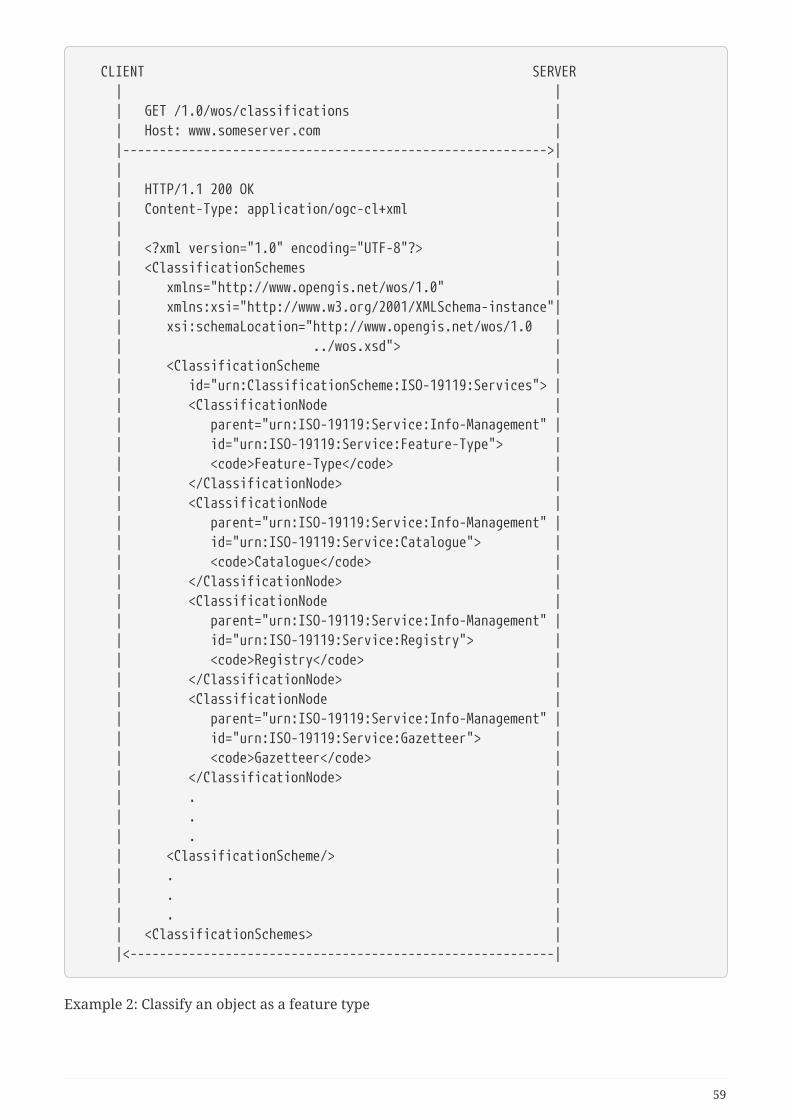
CLIENT SERVER | | | GET /1.0/wos/classifications | | Host: www.someserver.com | |---------------------------------------------------------->| | | | HTTP/1.1 200 OK | | Content-Type: application/ogc-cl+xml | | | | <?xml version="1.0" encoding="UTF-8"?> | | <ClassificationSchemes | | xmlns="http://www.opengis.net/wos/1.0" | | xmlns:xsi="http://www.w3.org/2001/XMLSchema-instance"| | xsi:schemaLocation="http://www.opengis.net/wos/1.0 | | ../wos.xsd"> | | <ClassificationScheme | | id="urn:ClassificationScheme:ISO-19119:Services"> | | <ClassificationNode | | parent="urn:ISO-19119:Service:Info-Management" | | id="urn:ISO-19119:Service:Feature-Type"> | | <code>Feature-Type</code> | | </ClassificationNode> | | <ClassificationNode | | parent="urn:ISO-19119:Service:Info-Management" | | id="urn:ISO-19119:Service:Catalogue"> | | <code>Catalogue</code> | | </ClassificationNode> | | <ClassificationNode | | parent="urn:ISO-19119:Service:Info-Management" | | id="urn:ISO-19119:Service:Registry"> | | <code>Registry</code> | | </ClassificationNode> | | <ClassificationNode | | parent="urn:ISO-19119:Service:Info-Management" | | id="urn:ISO-19119:Service:Gazetteer"> | | <code>Gazetteer</code> | | </ClassificationNode> | | . | | . | | . | | <ClassificationScheme/> | | . | | . | | . | | <ClassificationSchemes> | |<----------------------------------------------------------|
Example 2: Classify an object as a feature type
59

CLIENT SERVER | | | POST /1.0/wos/classification HTTP 1.1 | | Host: www.someserver.com | | Content-Type: application/ogc-cl+xml | | | | <?xml version="1.0" encoding="UTF-8"?> | | <Classification | | xmlns="http://www.opengis.net/wos/1.0" | | xmlns:xsi="http://www.w3.org/2001/XMLSchema-instance"| | xsi:schemaLocation="http://www.opengis.net/wos/1.0 ../wos.xsd"> | <ClassifiedObjectId>urn:uuid:ce28abbe-d17e-426d-8dae-a7977442a7be</ClassifiedObjectId> | <ClassificationNode>urn:ISO-19119:Service:Feature-Type</ClassificationNode> | </Classification> | | | |---------------------------------------------------------->| | | | HTTP/1.1 200 OK | | Location: /1.0/wos/classifications/12345 | |<----------------------------------------------------------|
60
Chapter 9. Future WorkThis section summaries the key findings and defines work items that are recommended for futureOGC Innovation Program initiatives to further analyze the GFM capabilities.
The GFM activity has been a proof of concept, targeting the initial requirements from two differentimplementation angles. Both approaches have successfully demonstrated that it is very wellpossible to accommodate non-geospatial information and it’s associations with related data asfeatures in the GFM.
So what is next? This testbed experimented with the GFM as such, did an in-depth analysis of theUML model and its implementation, and verified that the GFM can serve well as an associationmodel between any type of features. That is, for example, a video stream can be associated to aTwitter message, or an individual feature in a database can be associated with the results of acomplex stream processing workflow. The associations can be features themselves that, ifnecessary, associate further association features. This approach allows for graphs of features andassociation features, which is an extremely powerful approach that needs to be further explored. Inorder to further demonstrate that the concept is a viable approach and the capabilities of the GFMgo well beyond the traditional geoinformation-centric application areas it was originally designedfor, a larger scale interoperability experiment would be required. The following aspects requirefurther research:
• Analogy to Linked Data: The feature to feature with association is pretty similar to the LinkedData approach that uses triplets to describe associations between features. Just, the GFMapproach is even more powerful because the predicate is not constrained but a first class objectin its own right. How does this extend the capabilities of Linked Data and how does it allowproper integration with existing Linked Data implementations?
• Semantic of Association Features: The approach documented in this engineering reportbecomes more powerful if the semantics of the association features are well defined. TheSemantic Web domain uses ontologies to define the semantics behind objects. Semantic Webapproaches should be analyzed to better understand how the full potential of the GFMapproach can be leveraged.
• Integration of different semantics: The flexibility of the approach allows for differentsemantics to be incorporated into knowledge graphs (that consist of features and associationsfeatures). Future activities need to analyze how these different semantics can be catered for.Providing access to ontologies is certainly a first step, but potential access and availability issuesneed to be handled.
• Definition of a core set of association features: The development of a core set of associationtypes and corresponding association features would help the geospatial domain to make use ofthe model more efficiently. A process needs to be developed that allows the OGC community todevelop, maintain, and provide this core set. The OGC Naming Authority needs to be part of thatprocess.
• Implementation details: The Testbed-12 research has used a limited subset of possible datatypes and access mechanisms. It is recommended that future initiatives include aspects such as:
• A greater variety of data types and formats
61

• Software analytics generating new information
• Real time data feeds
• More complex exercise scenarios
• Interoperability experiments across the implementation approaches
• Defined client requirements and resources
62
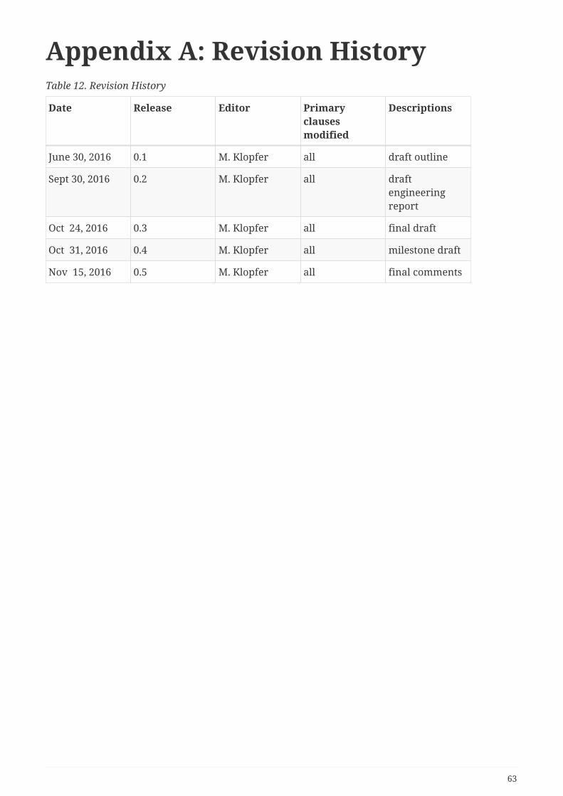
Appendix A: Revision HistoryTable 12. Revision History
Date Release Editor Primaryclausesmodified
Descriptions
June 30, 2016 0.1 M. Klopfer all draft outline
Sept 30, 2016 0.2 M. Klopfer all draftengineeringreport
Oct 24, 2016 0.3 M. Klopfer all final draft
Oct 31, 2016 0.4 M. Klopfer all milestone draft
Nov 15, 2016 0.5 M. Klopfer all final comments
63

Appendix B: Bibliography[1] Roswell, Charles: Modeling of Geographic Information. In: Kresse, Wolfgang and D. Danko:Springer Handbook of Geographic Information. Springer, 2012
64