Embed Size (px)
Citation preview

Texas Strategic Mapping Program Lidar Initiatives
June 7, 2017
Houston-Galveston Advisory Council
Monthly Geographic Data Workgroup Meeting
Houston, Texas

StratMap Program
• Maintain authoritative, trusted state geospatial layers based on national standards. Acquire new geospatial data Update existing geospatial data
• Define a common mapping standard to ensure consistent, high quality data for the State of Texas and the public.
• Attract partnerships to increase the purchasing power of public funds.
StratMapContract
Initiated/held by Department of Information Resources
Administered by TWDB-TNRIS
• Pool resources
• Lower cost per entity
• Higher quality service
• Save time – no individual procurements
Established 2016 Expires 2020
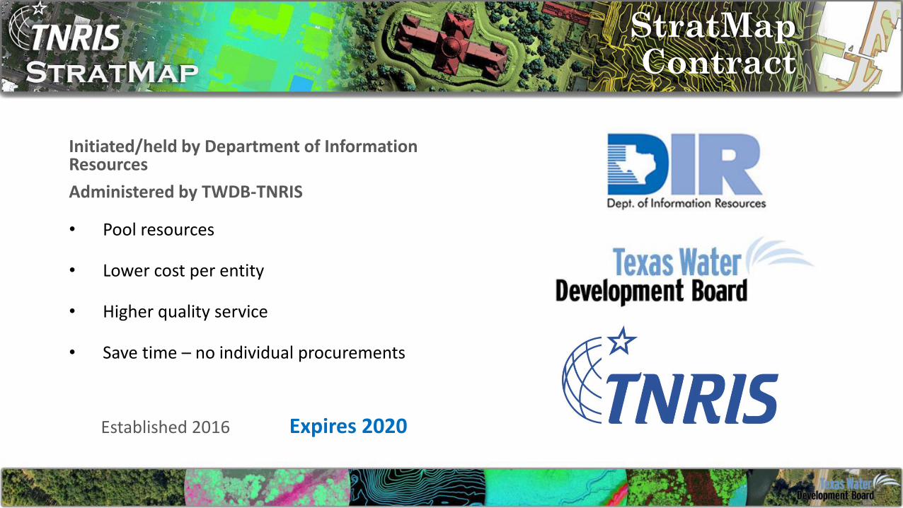
StratMapParticipants
• Bandera County River Authority and Groundwater District
• Bexar County Appraisal District
• Bexar Metro 9-1-1
• Brazos Central Appraisal District
• Brazos County Emergency Communications
• Brownsville Public Utility Board
• Central Texas Council of Governments
• City of Bryan
• City of College Station
• City of Georgetown
• City of Houston
• City of Laredo
• City of McAllen
• City of Palestine
• City of Pharr
• City of Port Isabel
• City of San Antonio
• City of San Marcos
• City of Tyler
• City of Weslaco
• City of Round Rock
• Edwards Aquifer Authority
• Fort Bend County Drainage District
• Hidalgo County Drainage District #1
• Hidalgo County Metropolitan Planning Organization
• Hidalgo County Regional Mobility Authority
• Laguna Madre Water District
• Lower Rio Grande Valley Development Council
• National Geospatial-Intelligence Agency
• Railroad Commission of Texas
• Sabine River Authority
• San Antonio River Authority
• Smith County
• Smith County 9-1-1
• Smith County Appraisal District
• Tarrant Regional Water District
• Texas A&M University
• Texas Commission on Environmental Quality
• Texas Commission on State Emergency Communications
• Texas Department of Transportation
• Texas Forest Service
• Texas General Land Office
• Texas Municipal Power Agency
• Texas Parks and Wildlife Department
• Texas Water Development Board
• Trinity River Authority
• University Lands
• U.S. Army Corps of Engineers
• U.S. Fish & Wildlife
• U.S. Geological Survey
• USDA Natural Resources Conservation Service
• Williamson County
State AgencyLocal/Municipality Regional Agency Federal Agency
Past StratMap Partners

StratMapVendors
• AECOM
• AppGeo
• Dewberry
• Esri
• Fugro Geospatial
• GeoComm
• Geophex
• Harris
• Infogroup
• Hexagon Geospatial
• Merrick & Company
• PenBay Solutions
• RazorTek
• SADA Systems
• Sanborn
• Surdex
• Tessellations
• West
Green = Lidar Providers
Pre-qualified Vendor Pool
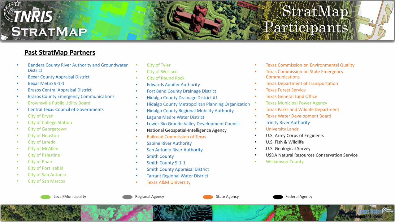
StratMapVendors
Geospatial Data & Services

StratMap Contract
1. Project initiation
2. Compile Statement of Work (SOW)
3. Release Solicitation w/SOW to StratMap Vendor Pool
4. Evaluate proposal responses
5. Purchase Order sent to winning vendor(s) from each
partner referencing StratMap Contract(s)
6. Ongoing project management from TNRIS or on your own
7. Quality Assurance and Quality Control (QA/QC)
8. Data review and acceptance
How it works

Lidar Acquisitions
• Central and East Texas Projects were awarded grants from the USGS 3-D Elevation Program (3DEP) totaling almost $600, 000.00.
• Central and East Texas Projects were acquired by Fugrowith third-party QA/QC by AECOM Technical Services. Expected Delivery October 2017 and January 2018.
• Coastal Lidar Project was acquired by Sanborn with third-party QA/QC by AECOM Technical Services. Expected delivery September 2017.
2016-2017 StratMap Lidar Acquisitions

Lidar Acquisitions
• TWDB is currently plans to commit $500,000.00 for a coastal acquisition this winter to replace the remainder of 2006 FEMA data.
• StratMap will pursue 3DEP funding for eligible areas.
• The coastal region is almost entirely eligible and has been identified as a priority areas for federal 3DEP partners.
2017-2018 Lidar Acquisition

Lidar Acquisitions
• H-GAC would directly benefit as TWDB AOI is adjacent to and includes portions of H-GAC’s area.
• Total acquisition of ~9,400 square miles to recover non QL2 data in H-GAC area.
• TWDB is pursuing a coastal acquisition to replace the FEMA 2006 collection.
• TWDB can potentially cover ~3,600 square miles within the H-GAC Area.
• Potential USGS 3DEP funding of 30% would cover ~2,800 square miles.
• Estimated cost per square mile: $125-$175.
A partnership with TWDB to recapture non QL2 data for the H-GAC area with the addition of 3DEP funding has the potential to carry discount of ~68%. In this situation H-GAC would only pay for around 3,000 of the 9,400 square miles for that acquisition.

Lidar Specifications
TNRIS USGS QL20.5m NPS/4 ppsm 0.71m NPS/ 2 ppsm
RMSEz 10cm(non-vegetated)
RMSEz 10cm(non-vegetated)
Classifications: 1,2,3,4,5,6,7,9,10,13,14
Classifications:1,2,7,9,10,17,18
The Texas Lidar Specification is modeled very closely to the USGS Lidar Specification version 1.2 and the ASPRS Positional Accuracy Standards for Digital Geospatial Data
Vendor Delivered Products
• LAS Point Cloud• Hydro-flattened DEM• Hydro-breaklines• File level metadata• 3rd party QAQC Report
TNRIS Derivative Datasets
• 2ft and 5ft cartographic contours• Building footprints
All data and derivative datasets will be publicly available for download at TNRIS.org.

Schedule
December-February
•Acquisition
November
•3DEP Award•Purchase orders to vendor from Partners
October
•3DEP Grant Proposal
September
•Evaluate proposals•Award
August
•SOW to DIR•Post SOW
• Beginning of August is the cut off for SOW participation and ability to maximize cost share. Partners in SOW will gain additional cost share from 3DEP funding, if awarded.
• November will be last chance to participate at proposed cost by vendor. Late additions will not be able to capitalize on 3DEP funding for their areas.
• Acquisition will begin in December when leaf off conditions occur.
Timeline

• Imagery from Google
• Jan 2015 – Aug 2017 Pilot
• WMTS/WMS links
• 6-inch Statewide, no color
infrared
• Leaf-on/Leaf-off Mix
• Automatic Imagery Updates
• Sep1, 2017 Subscription Fee
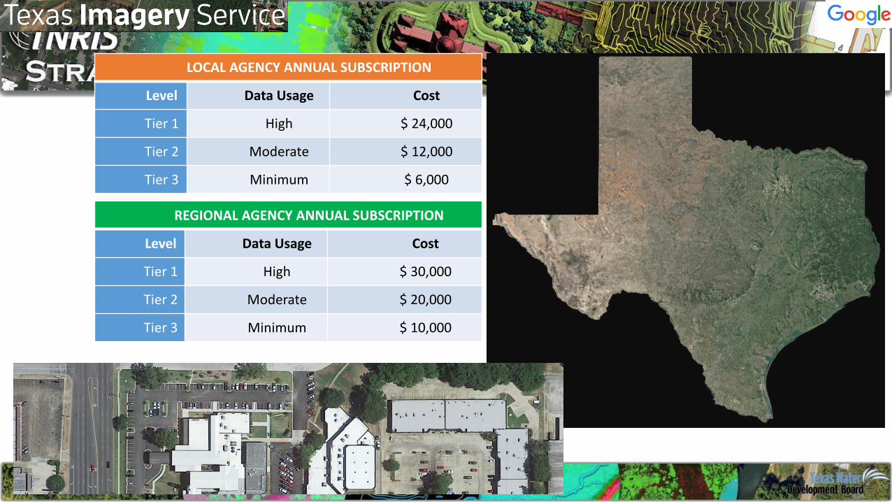
REGIONAL AGENCY ANNUAL SUBSCRIPTION
Level Data Usage Cost
Tier 1 High $ 30,000
Tier 2 Moderate $ 20,000
Tier 3 Minimum $ 10,000
LOCAL AGENCY ANNUAL SUBSCRIPTION
Level Data Usage Cost
Tier 1 High $ 24,000
Tier 2 Moderate $ 12,000
Tier 3 Minimum $ 6,000

Lidar Updates
• Currently 60,000 square miles of new lidar in production from StratMap and FEMA.
• Data should be delivered this winter, and will become available via TNRIS.org.
• Two FEMA acquisitions have been postponed until winter 2017-2018.
• Status of projects can be seen on the TNRIS lidar status map.

Updates

Thank you!Joey Thomas
RDC Team Lead & Elevation Data Specialist/Project Manager
512.463.8851
Gayla MullinsRemote Sensing Specialist / Project Manager
512.463.7104