Embed Size (px)
Citation preview
The 2011 Preserve America Progress Report
Produced by
U.S. Department of the Interior
Bureau of Land Management
Cultural Resource Management Program
Washington, DC
September 2011
Suggested citation:BLM cultural resource management program. 2011. The 2011 Preserve America Progress Report. Department of the Interior.
Bureau of Land Management, Division of Cultural, Paleontological Resources, and Tribal Consultation, Washington, DC.
Production services provided by:Bureau of Land ManagementNational Operations CenterInformation and Publishing Services SectionP.O. Box 25047Denver, CO 80225
BLM/WO/GI-11/010+8100
The 2011 Preserve America Progress ReportSeptember 2011

The 2011 Preserve America Progress Report iii
Table of Contents
I. Executive Summary ........................................................................................................... 1
II. Background ....................................................................................................................... 3
III. Overview of the Cultural Resource Managment Program .................................................. 5
IV. The BLM Budget ............................................................................................................ 11
V. The BLM’s Cultural Resource Management Program Statistics Update ........................... 21
VI. Updates to Program Policy and Procedures ...................................................................... 27
• BLM Tribal Consultation Outreach ........................................................................... 27
• Revision of the BLM Programmatic Agreement ......................................................... 28
• Oil and Gas Leasing Reform ...................................................................................... 29
VII. Heritage Education .......................................................................................................... 31
VIII. Exemplary Partnerships ................................................................................................... 39
• Youth Project Partnerships .......................................................................................... 39
• Tribal Partnerships ..................................................................................................... 45
• Heritage Tourism Partnerships ................................................................................... 49
• Data Sharing Partnership ........................................................................................... 55
References ................................................................................................................................... 59
Appendicies ................................................................................................................................. 62
Appendix A: List of Acronyms ..................................................................................................... 62
Appendix B: BLM Cultural Resource Management Program
Fact Sheet (FY 2008-2010 Data) ................................................................................................. 63

The 2011 Preserve America Progress Report 1
I. Executive SummarySection 3(c) of Executive Order 13287 on “Preserve America,” signed by President George W. Bush
on March 3, 2003, requires each federal agency with real property management responsibilities
to prepare a progress report every 3 years by September 30 on identifying, protecting, and using
historic properties in its ownership. The BLM is to make the report available to the Secretary of the
Interior and the Advisory Council on Historic Preservation (ACHP).
The ACHP’s April 2011 “Advisory Guidelines Implementing Executive Order 13287, Preserve
America” provides a framework for the Bureau of Land Management (BLM) “2011 Preserve
America Progress Report.” This report covers fiscal years (FYs) 2008, 2009, and 2010 and
emphasizes the BLM’s cultural resource management (CRM) program’s achievements. These
include the BLM’s initiative to assess and improve its tribal consultation, especially under cultural
resource authorities; the BLM’s initiative to update its national programmatic agreement to
improve processes of Section 106 of the National Historic Preservation Act (NHPA); and the
BLM’s exemplary tribal, youth project, heritage tourism, and data sharing partnerships.
The BLM manages more than 245 million surface acres of public land and 700 million acres of
subsurface mineral estate, more land than any other agency. The BLM has a multiple-use mission
to manage the public lands in a manner that protects the quality of scientific, scenic, historical,
ecological, environmental, air and atmospheric, water resource, and archaeological values and
provides opportunities for outdoor recreation, while recognizing the nation’s need for domestic
sources of minerals, food, timber, and fiber. The BLM’s CRM program is faced with the unique
challenge of ensuring identification, protection, and use of historic properties in a manner
consistent with the BLM’s multiple-use mandate.
“The 2011 Preserve America Progress Report” provides updated information on BLM activities
mentioned within Sections 106 and 110 of the NHPA. Through FY 2010, more than 21 million
acres have been surveyed for historic properties (8 percent of BLM land), with an average of
855,387 acres surveyed annually from FY 2008 through FY 2010. The majority of the inventory
work is funded by land use applicants and performed by one of the more than 700 consultants
permitted by the BLM. In FY 2008, 16,450 projects triggered a literature search at a minimum,
and 9,947 projects triggered an intensive Class III field inventory. In FY 2010, this work dropped
to 10,840 and 5,831 respectively. Cumulatively, more than 328,000 cultural properties have been
The 2011 Preserve America Progress Report2
recorded in surveys on BLM-administered surface lands
through FY 2010, and more than 4 million sites are
estimated to exist.
Between FY 2008 and FY 2010, the BLM determined
more than 33,000 cultural properties eligible for
the National Register of Historic Places (National
Register). During the same period, the BLM added
12 National Register registrations, containing 302
individual contributing properties, and also added
one national historic landmark. In FY 2010, the
BLM placed 471 more properties under some form of
protection than in FY 2007. From FY 2008 through
FY 2010, there were 1,032 new signs, 309 new gates or
fencing, 851 stabilization actions, and 969 maintenance
activities completed. An additional 2,468 properties
were assigned some form of administrative protection,
such as closure, withdrawal from mineral leasing,
or designation as an area of critical environmental
concern. The BLM continues to educate American
children, families, and teachers about their rich heritage
resources through the heritage education program.
The program reached 64,000 individuals per year from
FY 2008 through FY 2010. The BLM also actively
investigates violations of the Archaeological Resources
Protection Act (ARPA) and Native American Graves
Protection and Repatriation Act (NAGPRA).
From FY 2008 through FY 2010, the BLM engaged
in an extensive outreach to tribes to enhance tribal
consultation efforts, especially under cultural
resources authorities, and advance government-to-
government relationships. Through partnerships, the
BLM advanced youth stewardship and engagement
in resource protection, strengthened BLM-tribe
relationships, improved cultural resources data
management, and furthered heritage tourism
opportunities.
The 2011 Preserve America Progress Report 3
II. BackgroundSection 3(b) of Executive Order 13287 on “Preserve America,” signed by President George W.
Bush on March 3, 2003, directed federal agencies with real property management responsibilities to
review their regulations, policies, and procedures for compliance with Sections 110 and 111 of the
NHPA and to make the results of the review available to the secretary of the agency and the ACHP
by September 30, 2004. Section 3(c) of the executive order requires that each agency prepare a
progress report on identifying, protecting, and using their historic properties by September 30,
2005, and every third year thereafter, and make the report available to the ACHP and the secretary
of the agency. The ACHP then prepares a report on the state of the federal government’s historic
properties and their contribution to local economic development and will submit their next report
to the President in February 2012.
In the BLM’s initial September 2004 report, the BLM described its multiple-use mandate and
the vast expanse of public land it administers; the number, diversity, and condition of the cultural
resources it manages, including museum collections in internal and nonfederal repositories; the
regulations, policies, and procedures under which it manages its cultural resources, including the
national programmatic agreement and state-specific protocols under which the BLM complies
with NHPA Section 106 responsibilities; the challenges confronting the agency in managing its
cultural resources and the extraordinary ways in which the BLM meets these challenges; the sources
of internal and external funds the BLM applies to protect, study, and use its resources; and the
heritage tourism opportunities and economic benefits that the BLM’s cultural resources provide.
The BLM’s September 2005 progress report expanded on the BLM’s public outreach, education,
tourism, and other partnership activities and updated the BLM’s progress in meeting the intent
of the executive order. The report also described updates to the BLM comprehensive 8100
manual series and BLM Handbook H-8120-1 Guidelines for Conducting Tribal Consultation,
and discussed the new website celebrating the 100th anniversary of the Antiquities Act of 1906.
The BLM’s September 2008 progress report provided updates on previously reported activities;
expanded on the Department of the Interior (DOI) and the BLM missions and strategic plan;
and described the BLM Operating Plan, the CRM program’s performance measures, appropriated
funding levels and other major programs and sources of support, and heritage assets and their
placement within the DOI and the BLM Asset Management Plans. The 2008 report also
The 2011 Preserve America Progress Report4
elaborated on the museum collection management
program, including significant advancements in
collections management between FY 2005 and
FY 2007.
The September 2011 progress report provides updates
on the BLM’s organizational changes and outlines
FY 2008 through FY 2010 performance measures,
budget, and NHPA Section 110 activities and heritage
education efforts. This report also describes the
BLM’s tribal consultation outreach and oil and gas
leasing reform initiatives; highlights success stories;
and provides numerous examples of exemplary tribal,
youth, and heritage tourism partnerships.
The 2011 Preserve America Progress Report 5
III. Overview of the Cultural Resource Management Program
The DOI Mission and Strategic PlanMission: The DOI protects and manages the nation’s natural resources and cultural heritage;
provides scientific and other information about those resources; and honors its trust responsibilities
or special commitments to American Indians, Alaska Natives, and affiliated island communities.
In the United States Department of the Interior Strategic Plan for Fiscal Years 2011-2016, five
mission areas provide the department’s overarching stewardship responsibilities and define its
long-term areas of focus (DOI 2011). The combined mission areas contain 23 goals, including
five primary goals. Each goal has one or more strategies that define how the department plans to
accomplish it. These mission areas are:
• Provide natural and cultural resource protection and experiences.
• Sustainably manage energy, water, and natural resources.
• Advance government-to-government relationships with Indian nations and honor
commitments to insular areas.
• Provide a scientific foundation for decisionmaking.
• Build a 21st century Department of the Interior.
The BLM Mission It is the mission of the BLM to sustain the health, diversity, and productivity of the public lands
for the use and enjoyment of present and future generations. The BLM mission supports the DOI
mission and 2011-2016 strategic plan, in particular mission areas 1 and 2. The BLM manages and
conserves resources for multiple use and sustained yield on more than 245 million acres of public
land, or 42 percent of the land managed by the federal government. The BLM’s multiple-use
mandate under the Federal Land Policy and Management Act (FLPMA) includes responsibility for
renewable and conventional energy and mineral development, forestry management, timber and
biomass production, wild horse and burro management, domestic livestock grazing, and recreation
and resource protection at sites of natural, scenic, scientific, and historical value, including the
National Landscape Conservation System (NLCS). The BLM, including the CRM program,
receives program-specific appropriated funding to carry out these responsibilities.
The 2011 Preserve America Progress Report6
The CRM ProgramThe BLM’s CRM program aligns with the DOI stra-
tegic plan’s mission area 1, which is to provide natural
and cultural resource protection and experiences (DOI
2011). The program is responsible for the large, diverse,
culturally significant, and scientifically important aggre-
gation of world-renowned archaeological sites, historic
structures, paleontological localities, national scenic
and historic trails, and wild and scenic rivers on public
lands, as well as the associated museum collections,
records, and geospatial data. The long-term goals of the
program focus on inventorying, stabilizing, protecting,
and monitoring these resources. The program also sup-
ports the DOI strategic plan’s mission area 2, which is to
sustainably manage energy, water, and natural resources
(DOI 2011), by managed compliance with Section 106
and related National Environmental Policy Act (NEPA)
compliance for land-use actions on the public lands that
may affect historic properties.
The BLM Washington Office staff administers the
CRM program through oversight and policy. The BLM
Director is the senior policy official under the “Preserve
America” executive order. The Director established the
BLM Preservation Board in 1997 to provide policy and
procedural advice to the BLM. The board is chaired by
the BLM federal preservation officer, who works within
the Directorate of Renewable Resources and Planning
(AD-200) in the Division of Cultural, Paleontological
Resources, and Tribal Consultation (WO-240). Deputy
preservation officers in each of the 12 BLM state offices
are ex officio members of the board, and four field office
managers and two field specialists serve term appoint-
ments. The board meets twice a year and publishes
its meeting reports on the Internet. The BLM’s state
directors direct implementation of the CRM program
and establish priorities for each of
12 state offices. The BLM’s managers make land
management decisions and ensure the CRM program
meets legal and professional standards for the more than
140 district and field offices.
In 2009, President Barack Obama signed into law
the Omnibus Public Land Management Act of 2009
(Public Law 111-11). The act legislatively established
the BLM’s NLCS which was created administratively
by Secretary of the Interior Bruce Babbitt in 2000. The
NLCS provides a framework for managing the BLM’s
specially designated conservation areas as part of the
BLM’s multiple-use mission. The mission of the NLCS
is to conserve, protect, and restore nationally significant
landscapes that are recognized for their outstanding
cultural, ecological, and scientific values. The NLCS
includes almost 27 million acres and 900 individual
national monuments, national conservation areas,
wilderness areas, wild and scenic rivers, national scenic
and historic trails, and portions of the California Desert
Conservation Area. Congress also authorized creation
of a specific budget line for national monuments,
national conservation areas, and other congressional
designations. Previously, these areas were funded by
BLM programs, such as CRM, wildlife, and recreation.
The NLCS and Community Partnerships Directorate
(WO-170) has two branches, NLCS (WO-171) and
Education, Interpretation, and Partnerships (WO-172).
The BLM is held accountable for performance on the
DOI mission areas, which are supported by related
end outcome goals that guide a collection of related
programs and services. Each goal is supported by
quantitative performance measures—intermediate
outcome goals and performance targets. The BLM
Operating Plan aligns program performance goals
and measures with these mission areas and links field
operations to local-level program elements (BLM
2007). Results are rolled up to departmental goals.
The 2011 Preserve America Progress Report 7
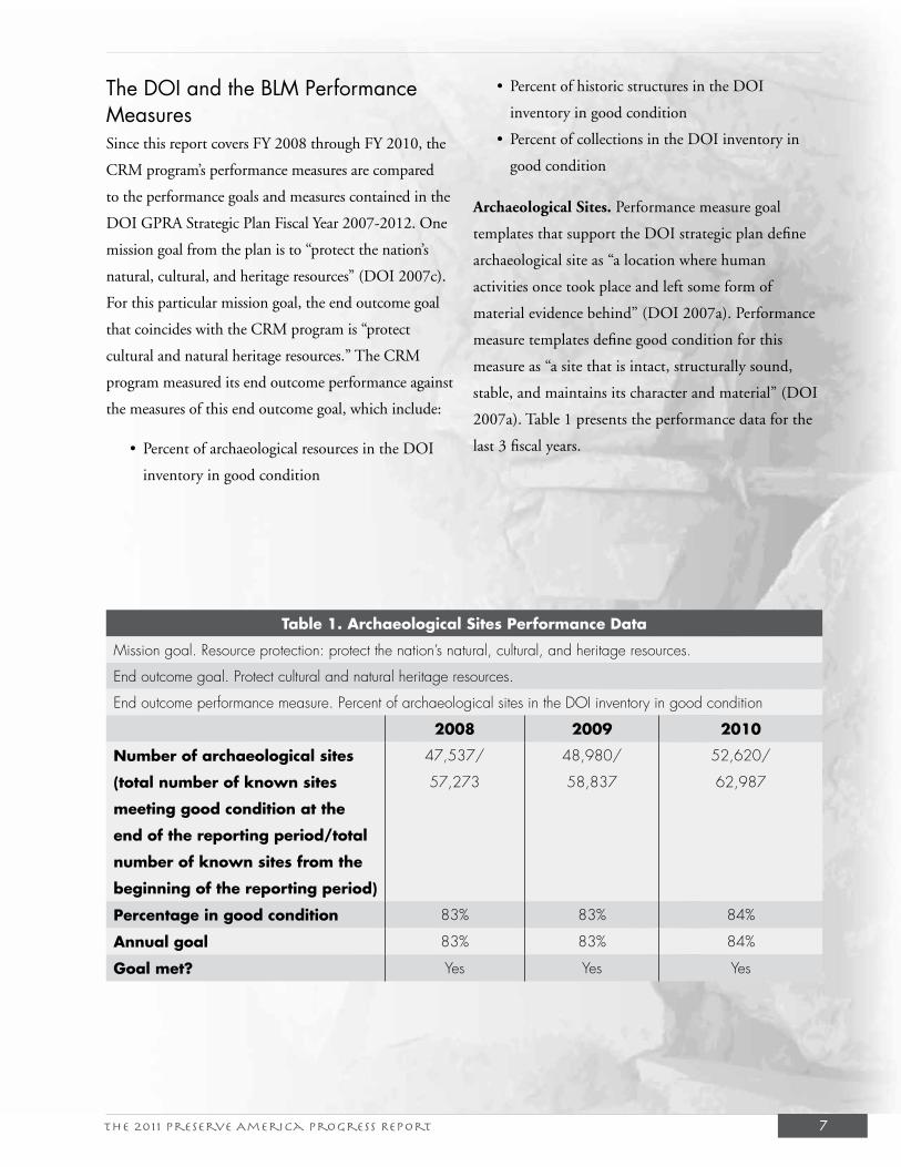
The DOI and the BLM Performance MeasuresSince this report covers FY 2008 through FY 2010, the
CRM program’s performance measures are compared
to the performance goals and measures contained in the
DOI GPRA Strategic Plan Fiscal Year 2007-2012. One
mission goal from the plan is to “protect the nation’s
natural, cultural, and heritage resources” (DOI 2007c).
For this particular mission goal, the end outcome goal
that coincides with the CRM program is “protect
cultural and natural heritage resources.” The CRM
program measured its end outcome performance against
the measures of this end outcome goal, which include:
• Percent of archaeological resources in the DOI
inventory in good condition
• Percent of historic structures in the DOI
inventory in good condition
• Percent of collections in the DOI inventory in
good condition
Archaeological Sites. Performance measure goal
templates that support the DOI strategic plan define
archaeological site as “a location where human
activities once took place and left some form of
material evidence behind” (DOI 2007a). Performance
measure templates define good condition for this
measure as “a site that is intact, structurally sound,
stable, and maintains its character and material” (DOI
2007a). Table 1 presents the performance data for the
last 3 fiscal years.
Table 1. Archaeological Sites Performance Data
Mission goal. Resource protection: protect the nation’s natural, cultural, and heritage resources.
End outcome goal. Protect cultural and natural heritage resources.
End outcome performance measure. Percent of archaeological sites in the DOI inventory in good condition
2008 2009 2010
Number of archaeological sites
(total number of known sites
meeting good condition at the
end of the reporting period/total
number of known sites from the
beginning of the reporting period)
47,537/
57,273
48,980/
58,837
52,620/
62,987
Percentage in good condition 83% 83% 84%
Annual goal 83% 83% 84%
Goal met? Yes Yes Yes
The 2011 Preserve America Progress Report8
This performance measure was developed by dividing
the total number of sites being monitored that are
stable, and thus considered to be in good condition at
the end of the reporting period, by the total number
of sites monitored from the beginning of the reporting
period in the BLM’s CRM annual report.
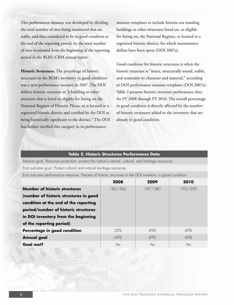
Historic Structures. The percentage of historic
structures in the BLM’s inventory in good condition
was a new performance measure in 2007. The DOI
defines historic structure as “a building or other
structure that is listed or eligible for listing on the
National Register of Historic Places, or is located in a
registered historic district and certified by the DOI as
being historically significant to the district.” The DOI
has further clarified this category in its performance
measure templates to include historic-era standing
buildings or other structures listed on, or eligible
for listing on, the National Register, or located in a
registered historic district, for which maintenance
dollars have been spent (DOI 2007a).
Good condition for historic structures is when the
historic structure is “intact, structurally sound, stable,
and maintains its character and material,” according
to DOI performance measure templates (DOI 2007a).
Table 2 presents historic structure performance data
for FY 2008 through FY 2010. The overall percentage
in good condition is directly affected by the number
of historic structures added to the inventory that are
already in good condition.
Table 2. Historic Structures Performance Data
Mission goal. Resource protection: protect the nation’s natural, cultural, and heritage resources.
End outcome goal. Protect cultural and natural heritage resources
End outcome performance measure. Percent of historic structures in the DOI inventory in good condition
2008 2009 2010
Number of historic structures
(number of historic structures in good
condition at the end of the reporting
period/number of historic structures
in DOI inventory from the beginning
of the reporting period)
182/362 187/380 192/390
Percentage in good condition 50% 49% 49%
Annual goal 49% 49% 49%
Goal met? Yes Yes Yes
The 2011 Preserve America Progress Report 9
At the outset of 2007, the BLM developed an initial
list of historic sites with standing structures on which
maintenance dollars were spent, which included 128
named places (not to be confused with the number of
standing structures). Out of the original list, 77 places,
or 66 percent, were deemed to be in good condition.
Since that time, additional historic structures have been
added to the inventory, which has had the effect of
reducing the overall percentage of structures in good
condition.
Museum Collections. Museum collections are defined
in the DOI Departmental Manual 411 as “assemblages
of objects, works of art, and/or historic documents,
representing the fields of archeology, art, ethnography,
biology, geology, paleontology, and history, collected
according to a rational scheme and maintained so they
can be preserved, studied, and interpreted for pub-
lic benefit.” A collection includes “cataloged and/or
uncataloged objects under the control of an administra-
tive unit/location, which may have multiple facilities/
spaces that house the collection, and may be managed
in bureau or nonbureau facilities” (DOI 1997). BLM
museum collections consist of archaeological and
historic artifacts, paleontological specimens, and the
records associated with these resources. Performance
measure goal templates defined the BLM inventory of
collections to include only BLM facilities that man-
age museum collections (DOI 2007a), and only three
internal facilities were reported for FY 2008 and FY
2009. However, in FY 2010, the BLM began reporting
all facilities that manage BLM museum collections, both
bureau-managed as well as other federal and nonfederal
repositories. Good condition for collections is based
on whether the museum storage and exhibit facilities
housing those collections meet at least 70 percent of
applicable DOI standards for environmental and secu-
rity controls for museum facilities. Adequate environ-
mental and security controls provide a stable and secure
environment to preserve museum objects and reduce
potential for deterioration or loss.
The BLM inventory of museum collections in FY
2008 and FY 2009 includes the three internal BLM
facilities authorized to curate museum collections:
the Anasazi Heritage Center in Dolores, Colorado;
the Billings Curation Center in Billings, Montana;
and the National Historic Oregon Trail Interpretive
Center in Baker City, Oregon. All three internal
BLM facilities curating museum collections meet
at least 70 percent of the applicable departmental
standards for museum facilities and are, therefore,
rated to be in good condition. At the end of FY 2010,
the BLM inventory of collections included the three
BLM facilities identified above, as well as three other
facilities managed by DOI bureaus and offices and 134
museums and universities. Table 3 presents museum
collection performance data for the last 3 fiscal years.
The BLM is working to improve the condition of its
museum collections by increasing staff expertise and
enhancing coordination with nonfederal facilities that
manage collections on behalf of the BLM.
The 2011 Preserve America Progress Report10
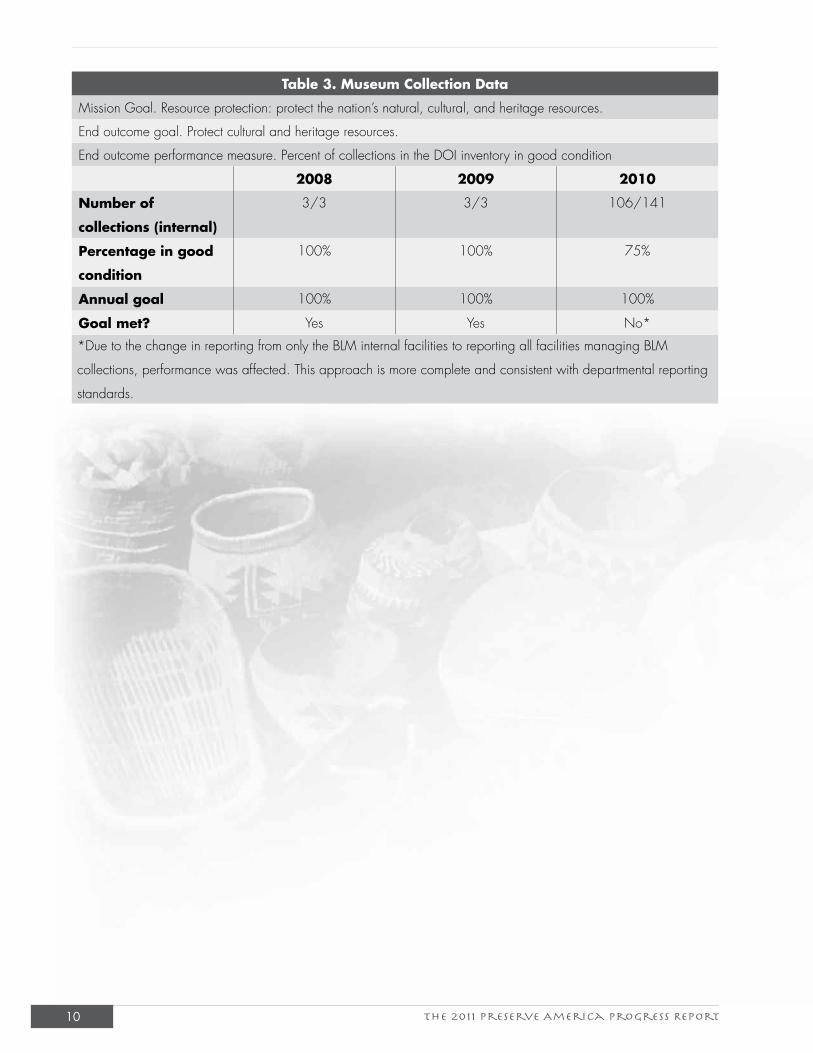
Table 3. Museum Collection Data
Mission Goal. Resource protection: protect the nation’s natural, cultural, and heritage resources.
End outcome goal. Protect cultural and heritage resources.
End outcome performance measure. Percent of collections in the DOI inventory in good condition
2008 2009 2010
Number of
collections (internal)
3/3 3/3 106/141
Percentage in good
condition
100% 100% 75%
Annual goal 100% 100% 100%
Goal met? Yes Yes No*
*Due to the change in reporting from only the BLM internal facilities to reporting all facilities managing BLM
collections, performance was affected. This approach is more complete and consistent with departmental reporting
standards.
The 2011 Preserve America Progress Report 11
IV. The BLM Budget
The BLM’s Emphasis AreasThe BLM ensures multiple use of the public lands by distributing funding across each of the DOI
strategic plan mission areas through the development of emphasis areas. In the spring of 2008, the
BLM identified six priority areas for the next 3 to 5 years (BLM 2008b). These long-term emphasis
areas were:
• Land Health. Conduct land resource protection and rehabilitation at the landscape level.
• National Landscape Conservation System. Conserve, protect, and restore communities and
partnerships; science; and recreation, education, and visitor services.
• Border Issues. Ensure public and employee safety and protect natural and cultural resources
in the U.S.-Mexico borderlands through law enforcement, communication, mitigation, and
coordination with other agencies and nearby communities.
• Energy Security. Provide dependable energy for the nation by providing access to public land
resources in an environmentally responsible manner.
• Community Growth. Redirect funding to high-growth areas, focusing on off-highway
vehicle and transportation management and protection of critical wildlife and cultural
resources.
• Nonenergy Commodity Use. Conserve working landscapes through grazing, timber
production, mineral material sales, and other commodity uses.
The emphasis areas are interdisciplinary because of the BLM’s multiple-use mandate and are
supplemented by annual funding initiatives. The BLM’s varied programs, including the CRM
program, are funded based on the emphasis areas and multiple-use program funding for projects
within the emphasis areas, as well as program priorities. The BLM develops its budget 2 years in
advance of the present year and is now developing its budget for 2013.
Cultural Resource Management Program FundingAppropriated funding is allocated to states through (1) base funds; (2) stable funds for labor
and operations for the permanent workforce and basic program structure; and (3) one-time, or
flexible, funds for specific projects based on the BLM’s emphasis areas and program priorities.
BLM state offices submit proposals for one-time funding projects through a database, and projects
are selected through established criteria at the headquarters level. The appropriation for CRM
The 2011 Preserve America Progress Report12
supports proactive management of cultural sites and
historic properties, paleontological localities, museum
collections and data associated with these resources, and
general tribal coordination.
The CRM program also works within all of the
BLM’s budget emphasis areas because of the NHPA
Section 106 compliance requirements. BLM states
charge the costs associated with processing cultural
and paleontological resource use permits and tribal
consultations on specific projects or classes of
undertakings to benefiting subactivities. The BLM
CRM program’s long-term goals are to manage and
protect heritage resources; maintain oversight of the
BLM’s NHPA Section 106 conformance; and increase
recognition and understanding of the resources and the
program.
In addition to the funding appropriated to the
CRM program by Congress, the program also
receives funding from outside sources and other
BLM programs, including the BLM Division of
Decision Support, Planning, and NEPA (WO-
210), the challenge cost share (CCS) program, and
deferred maintenance program. The CCS partners
and volunteers aid the CRM program’s appropriation
with in-kind contributions of upwards of $4-6 million
annually.
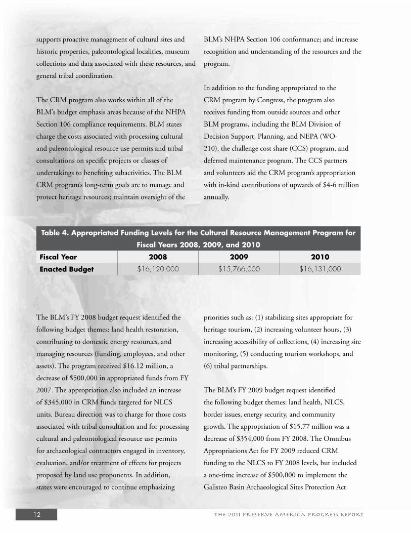
Table 4. Appropriated Funding Levels for the Cultural Resource Management Program for
Fiscal Years 2008, 2009, and 2010
Fiscal Year 2008 2009 2010
Enacted Budget $16,120,000 $15,766,000 $16,131,000
The BLM’s FY 2008 budget request identified the
following budget themes: land health restoration,
contributing to domestic energy resources, and
managing resources (funding, employees, and other
assets). The program received $16.12 million, a
decrease of $500,000 in appropriated funds from FY
2007. The appropriation also included an increase
of $345,000 in CRM funds targeted for NLCS
units. Bureau direction was to charge for those costs
associated with tribal consultation and for processing
cultural and paleontological resource use permits
for archaeological contractors engaged in inventory,
evaluation, and/or treatment of effects for projects
proposed by land use proponents. In addition,
states were encouraged to continue emphasizing
priorities such as: (1) stabilizing sites appropriate for
heritage tourism, (2) increasing volunteer hours, (3)
increasing accessibility of collections, (4) increasing site
monitoring, (5) conducting tourism workshops, and
(6) tribal partnerships.
The BLM’s FY 2009 budget request identified
the following budget themes: land health, NLCS,
border issues, energy security, and community
growth. The appropriation of $15.77 million was a
decrease of $354,000 from FY 2008. The Omnibus
Appropriations Act for FY 2009 reduced CRM
funding to the NLCS to FY 2008 levels, but included
a one-time increase of $500,000 to implement the
Galisteo Basin Archaeological Sites Protection Act
The 2011 Preserve America Progress Report 13
of 2004. The BLM FY 2009 Annual Work Plan
emphasized: (1) inventories in high-sensitivity areas
subject to looting and erosion, (2) preparing reports
for assistant United States attorneys for multiple grand
jury sessions for ARPA and NAGPRA violations,
(3) supporting the curation of collections recovered
during law enforcement operations, (4) conducting
Native American listening sessions on the BLM’s tribal
consultation policy and process, and (5) revising the
BLM national programmatic agreement.
The BLM’s FY 2010 budget request identified the
following budget themes: creating a new energy
frontier, tackling climate impacts, implementing the
21st Century Youth Conservation Corps initiative,
and protecting America’s treasured landscapes. The
appropriation for the CRM program of $16.13
million restored funding for the NLCS to FY 2009
levels. Congress established two new budget line
items in the appropriations for national monuments
and national conservation areas of the NLCS. The
FY 2010 appropriation also included a general
program increase of $500,000, a fixed cost increase of
$365,000, and an elimination of the Galisteo Basin
earmark from the 2009 enacted level. The BLM FY
2010 Annual Work Plan emphasized: (1) inventory in
high-sensitivity areas subject to looting and erosion;
(2) protecting, inventorying, and monitoring heritage
resources on newly designated wilderness lands; (3)
preparing reports for assistant U.S. attorneys for grand
jury sessions for violations of ARPA and NAGPRA;
and (4) implementing the Paleontological Resources
Preservation subtitle under the Omnibus Public Land
Management Act of 2009.
Division of Decision Support, Planning, and NEPA.
Between FY 2008 and FY 2010, landscape-level
studies have been funded by this division at $150,000,
$150,000, and $147,000, respectively. Between
three and five projects were supported annually with
this funding. These landscape-level studies provide
information that will be incorporated into the BLM’s
next generation of resource management plans to avoid
impacts to significant cultural resources, including
areas of traditional cultural importance to Indian
tribes, and will expedite land use authorizations by
identifying areas that are suitable and unsuitable for
development. These studies have included research
review of existing NHPA Section 106 inventory data,
development and testing of predictive models, Native
American cultural landscape studies, an ethnographic
place names study, comprehensive inventories along
historic trails, GIS modeling, and landscape-level
overviews of historic sites.
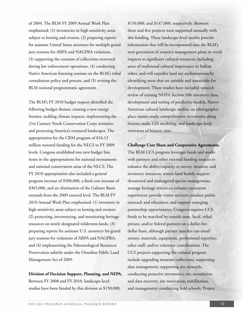
Challenge Cost Share and Cooperative Agreements.
The BLM CCS program leverages funds and works
with partners and other external funding sources to
enhance the ability/capacity to survey, monitor, and
inventory resources; restore land health; support
threatened and endangered species management;
manage heritage resources; enhance recreation
experiences; provide visitor services; conduct public
outreach and education; and support emerging
partnership opportunities. Congress requires CCS
funds to be matched by outside state, local, tribal,
private, and/or federal partners on a dollar-for-
dollar basis, although partner matches can entail
money, materials, equipment, professional expertise,
other staff, and/or volunteer contributions. The
CCS projects supporting the cultural program
include upgrading museum collections; supporting
data management; supporting site stewards;
conducting proactive inventories, site recordation,
and data recovery; site restoration, stabilization,
and management; conducting field schools, Project
The 2011 Preserve America Progress Report14
Archaeology Leadership Academies, national historic
trail certification, and ethnographic and landscape
studies.
Cooperative agreements are used when the primary
purpose is to provide public support or stimulation
and enhance public knowledge and appreciation of
the BLM’s role in the management of public lands
through development or distribution of interpretive
and/or educational materials and publications. From
FY 2008 through FY 2010, the CRM program received
$1,087,500, $975,200, and $1,098,460 in CCS
funding, respectively. Table 5 shows the amount funded
and the ratio of support.
Table 5. Summary of Challenge Cost Share/Cooperative Management Agreements
(FY 2008 – 2010)
Fiscal Year Number of
Projects
Cooperator
Input ($)
BLM Input ($) Cooperator: BLM
Ratio
2008 59 1,157,006 888,086 1.3:1
2009 88 1,973,726 1,909,100 1:1
2010 56 928,771 1,098,460 0.84:1
Construction and Deferred Maintenance Program.
The deferred maintenance program identifies critical
stabilization and rehabilitation needs and prioritizes
them for condition assessment and funding. Deferred
maintenance projects can involve cultural resources
and are prioritized according to DOI budget
guidance, which considers health and safety factors,
resource protection and compliance, or other deferred
maintenance needs. By DOI policy, only historic-era
standing properties and maintenance and construction
of infrastructure improvements that protect cultural
and fossil resources can be prioritized for funding.
Between FY 2008 and FY 2010, BLM-Arizona
programmed fire protection projects at Empire Ranch
and Fairbank Historic Townsite, an erosion control
project at Murray Springs Clovis Site, and preservation
of Browning Ranch House. The Browning Ranch
House preservation project was funded at $124,000
in 2010. The purpose of the project is to repair and
stabilize the structural integrity of the historic Brown
Ranch House in the Muleshoe Ranch Cooperative
Management Area.
Other Programs. Benefitting programs pay for NHPA
Section 106 staff work and support projects that
streamline the compliance work, such as the Cultural
Resources Data Sharing Partnership (CRDSP).
The CRDSP addresses data sharing, information
management, and support under the BLM’s national
programmatic agreement. The BLM programs that
historically support the CRDSP include rangeland
management, recreation resource management, oil
and gas management, lands and realty management,
resource management planning, mining law
administration, and wildland fire. The CRDSP is
discussed in greater detail in the partnerships section.
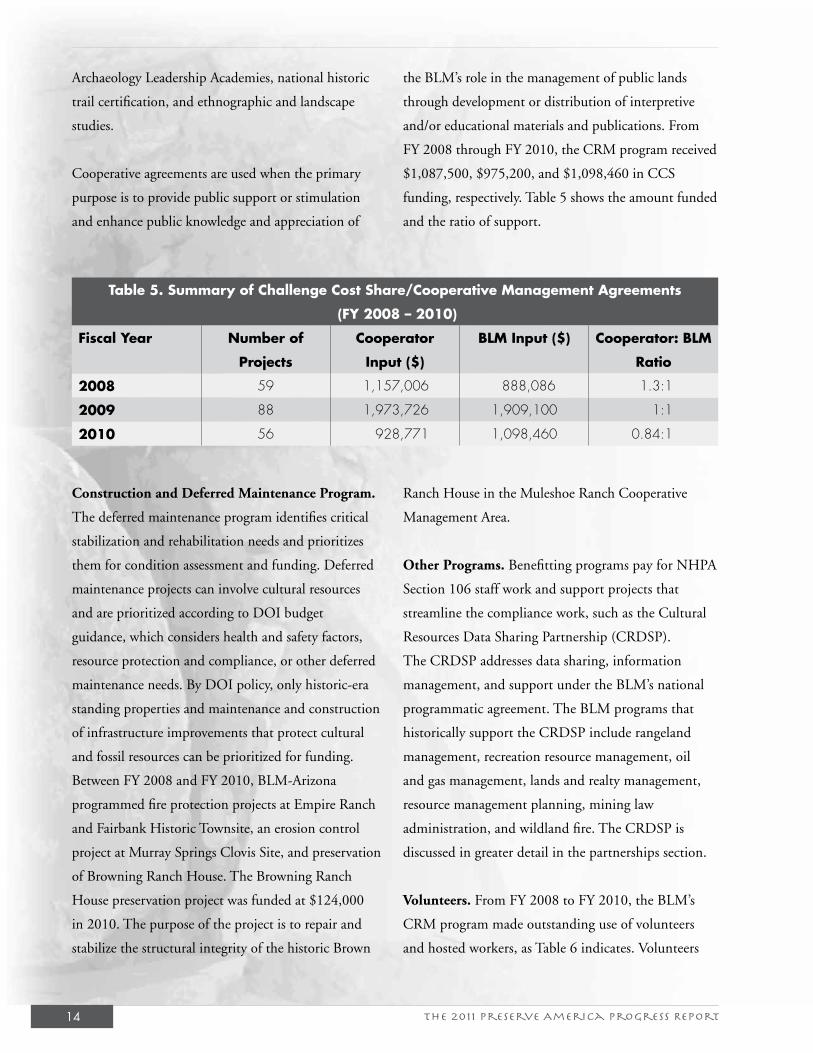
Volunteers. From FY 2008 to FY 2010, the BLM’s
CRM program made outstanding use of volunteers
and hosted workers, as Table 6 indicates. Volunteers
The 2011 Preserve America Progress Report 15
donate their time, and in some instances, equipment
and money to assist the BLM in a variety of jobs.
Donated or hosted workers, on the other hand, are
paid by another organization but work for the BLM
at no charge. Annually, volunteers donated between
6 and 11 percent of all BLM volunteer hours for the
benefit of the CRM program (BLM 2008a, 2009c,
2010c). Volunteers have assisted the BLM in the areas
of stabilization, site patrol and monitoring, detailed
recordation, excavation, documentary research,
interpretation, exhibit development, data automation,
website development, museum cataloging, site
mapping, and more. These partnerships augment the
appropriation of the CRM program’s budget between
$2 and $3 million annually and supplement the
proactive cultural heritage work accomplished.
Table 6. Volunteer Contributions to the Cultural Resource Management Program
(FY 2008-2010)Fiscal Year Volunteer
CRM HoursHosted Worker
CRM Hours
Total CRM Hours
Total BLM Hours
Estimated Monetary
Value
Percentage of
Volunteer Program
2008 104,495 4,272 108,767 1,202,257 $24,345,704 9.0
2009 126,935 2,270 129,205 1,132,936 $23,621,716 11.4
2010 73,761 2,229 75,990 1,244,782 $26,588,544 6.1
Other Funding Sources. The BLM actively pursues
other sources of funds where available. The Energy
Policy Act, enacted on August 8, 2005, requires the
BLM and other agencies to improve the efficiency of
oil and gas use authorizations on public land. The act
designated the following pilot project field offices:
Rawlins and Buffalo, Wyoming; Miles City, Montana;
Farmington and Carlsbad, New Mexico; Glenwood
Springs, Colorado; and Vernal, Utah. Pilot office needs
are funded through the special BLM Permit Processing
Improvement Fund, which consists of approximately
50 percent of the rentals received from oil and gas
leases in states other than Alaska between 2006 and
2015. The CRM program has used funds from pilot
offices for additional manpower, digitizing site records
and block surveys of areas that are high priority for
development.
Several BLM state offices utilize, directly or indirectly,
state government funding to accomplish critical cultural
resource work. The BLM-California State Office uses
off-highway vehicle “green sticker” funds from the State
of California to support the BLM site steward program,
and the BLM-Colorado State Office works through
nonfederal partners to tap into the State Historical Fund
to accomplish a wide range of cultural resource work.
In addition, the BLM applies for grants available to
federal agencies, including the Save America’s Treasures
grants program.
The 2011 Preserve America Progress Report16
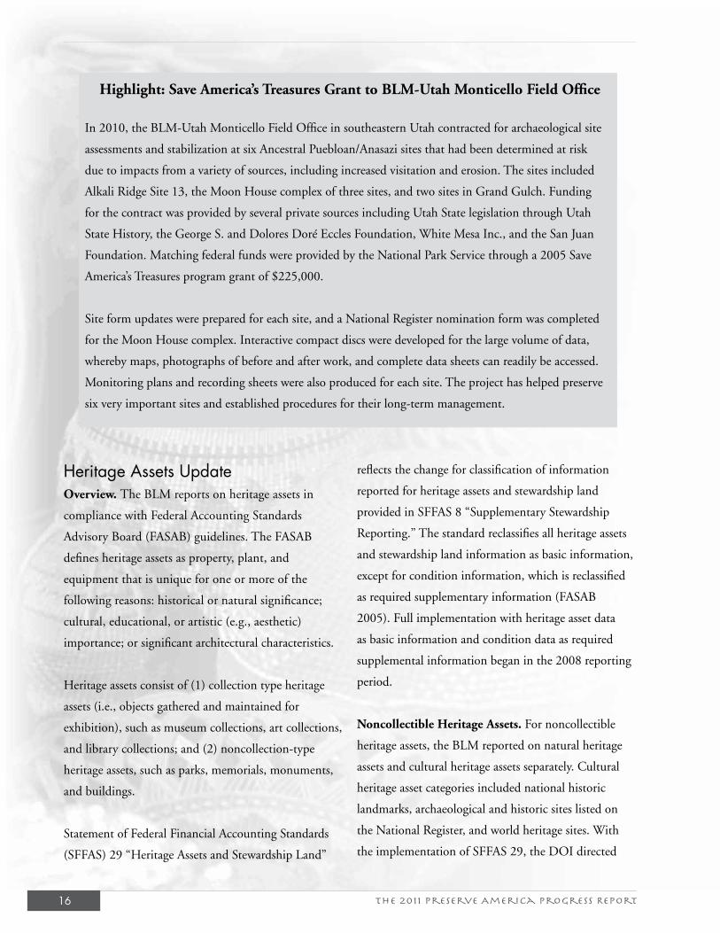
Highlight: Save America’s Treasures Grant to BLM-Utah Monticello Field Office
In 2010, the BLM-Utah Monticello Field Office in southeastern Utah contracted for archaeological site
assessments and stabilization at six Ancestral Puebloan/Anasazi sites that had been determined at risk
due to impacts from a variety of sources, including increased visitation and erosion. The sites included
Alkali Ridge Site 13, the Moon House complex of three sites, and two sites in Grand Gulch. Funding
for the contract was provided by several private sources including Utah State legislation through Utah
State History, the George S. and Dolores Doré Eccles Foundation, White Mesa Inc., and the San Juan
Foundation. Matching federal funds were provided by the National Park Service through a 2005 Save
America’s Treasures program grant of $225,000.
Site form updates were prepared for each site, and a National Register nomination form was completed
for the Moon House complex. Interactive compact discs were developed for the large volume of data,
whereby maps, photographs of before and after work, and complete data sheets can readily be accessed.
Monitoring plans and recording sheets were also produced for each site. The project has helped preserve
six very important sites and established procedures for their long-term management.
Heritage Assets UpdateOverview. The BLM reports on heritage assets in
compliance with Federal Accounting Standards
Advisory Board (FASAB) guidelines. The FASAB
defines heritage assets as property, plant, and
equipment that is unique for one or more of the
following reasons: historical or natural significance;
cultural, educational, or artistic (e.g., aesthetic)
importance; or significant architectural characteristics.
Heritage assets consist of (1) collection type heritage
assets (i.e., objects gathered and maintained for
exhibition), such as museum collections, art collections,
and library collections; and (2) noncollection-type
heritage assets, such as parks, memorials, monuments,
and buildings.
Statement of Federal Financial Accounting Standards
(SFFAS) 29 “Heritage Assets and Stewardship Land”
reflects the change for classification of information
reported for heritage assets and stewardship land
provided in SFFAS 8 “Supplementary Stewardship
Reporting.” The standard reclassifies all heritage assets
and stewardship land information as basic information,
except for condition information, which is reclassified
as required supplementary information (FASAB
2005). Full implementation with heritage asset data
as basic information and condition data as required
supplemental information began in the 2008 reporting
period.
Noncollectible Heritage Assets. For noncollectible
heritage assets, the BLM reported on natural heritage
assets and cultural heritage assets separately. Cultural
heritage asset categories included national historic
landmarks, archaeological and historic sites listed on
the National Register, and world heritage sites. With
the implementation of SFFAS 29, the DOI directed
The 2011 Preserve America Progress Report 17
bureaus and offices to report noncollectible heritage
assets as those properties that have been designated by
Congress, the President, or the Secretary of the Interior.
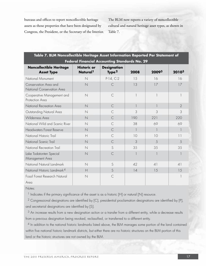
The BLM now reports a variety of noncollectible
cultural and natural heritage asset types, as shown in
Table 7.
Table 7. BLM Noncollectible Heritage Asset Information Reported Per Statement of
Federal Financial Accounting Standards No. 29
Noncollectible Heritage Asset Type
Historic or Natural1
Designation Type2 2008 20093 20103
National Monument N P-14, C-2 15 16 16
Conservation Area and National Conservation Area
N C 13 17 17
Cooperative Management and Protection Area
N C 1 1 1
National Recreation Area N C 1 1 2
Outstanding Natural Area N C 3 3 3
Wilderness Area N C 190 221 220
National Wild and Scenic River N C 38 69 69
Headwaters Forest Reserve N C 1 1 1
National Historic Trail H C 10 10 11
National Scenic Trail N C 3 5 5
National Recreation Trail N S 35 35 35
Lake Todatonten Special Management Area
N C 1 1 1
National Natural Landmark N S 42 41 41
National Historic Landmark4 H S 14 15 15
Fossil Forest Research Natural
Area
N C 1
Notes:
1 Indicates if the primary significance of the asset is as a historic [H] or natural [N] resource.
2 Congressional designations are identified by [C], presidential proclamation designations are identified by [P],
and secretarial designations are identified by [S].
3 An increase results from a new designation action or a transfer from a different entity, while a decrease results
from a previous designation being revoked, reclassified, or transferred to a different entity.
4 In addition to the national historic landmarks listed above, the BLM manages some portion of the land contained
within five national historic landmark districts, but either there are no historic structures on the BLM portion of this
land or the historic structures are not owned by the BLM.
The 2011 Preserve America Progress Report18
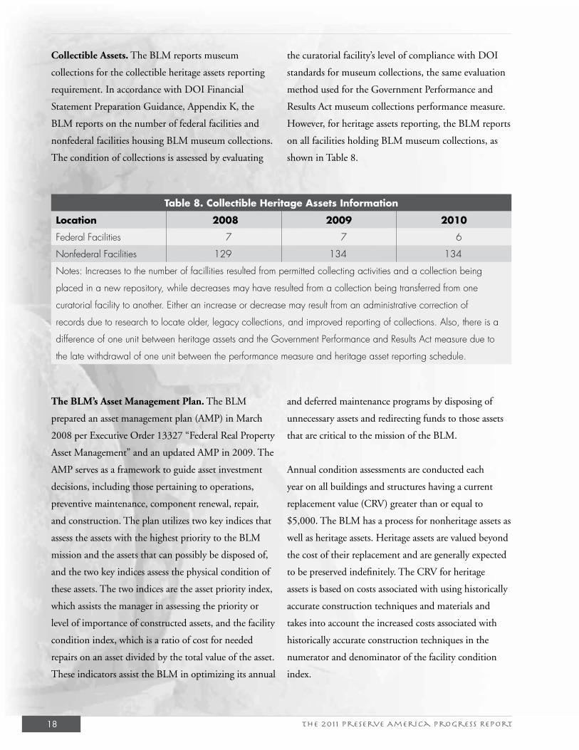
Collectible Assets. The BLM reports museum
collections for the collectible heritage assets reporting
requirement. In accordance with DOI Financial
Statement Preparation Guidance, Appendix K, the
BLM reports on the number of federal facilities and
nonfederal facilities housing BLM museum collections.
The condition of collections is assessed by evaluating
the curatorial facility’s level of compliance with DOI
standards for museum collections, the same evaluation
method used for the Government Performance and
Results Act museum collections performance measure.
However, for heritage assets reporting, the BLM reports
on all facilities holding BLM museum collections, as
shown in Table 8.
Table 8. Collectible Heritage Assets Information
Location 2008 2009 2010
Federal Facilities 7 7 6
Nonfederal Facilities 129 134 134
Notes: Increases to the number of facillities resulted from permitted collecting activities and a collection being
placed in a new repository, while decreases may have resulted from a collection being transferred from one
curatorial facility to another. Either an increase or decrease may result from an administrative correction of
records due to research to locate older, legacy collections, and improved reporting of collections. Also, there is a
difference of one unit between heritage assets and the Government Performance and Results Act measure due to
the late withdrawal of one unit between the performance measure and heritage asset reporting schedule.
The BLM’s Asset Management Plan. The BLM
prepared an asset management plan (AMP) in March
2008 per Executive Order 13327 “Federal Real Property
Asset Management” and an updated AMP in 2009. The
AMP serves as a framework to guide asset investment
decisions, including those pertaining to operations,
preventive maintenance, component renewal, repair,
and construction. The plan utilizes two key indices that
assess the assets with the highest priority to the BLM
mission and the assets that can possibly be disposed of,
and the two key indices assess the physical condition of
these assets. The two indices are the asset priority index,
which assists the manager in assessing the priority or
level of importance of constructed assets, and the facility
condition index, which is a ratio of cost for needed
repairs on an asset divided by the total value of the asset.
These indicators assist the BLM in optimizing its annual
and deferred maintenance programs by disposing of
unnecessary assets and redirecting funds to those assets
that are critical to the mission of the BLM.
Annual condition assessments are conducted each
year on all buildings and structures having a current
replacement value (CRV) greater than or equal to
$5,000. The BLM has a process for nonheritage assets as
well as heritage assets. Heritage assets are valued beyond
the cost of their replacement and are generally expected
to be preserved indefinitely. The CRV for heritage
assets is based on costs associated with using historically
accurate construction techniques and materials and
takes into account the increased costs associated with
historically accurate construction techniques in the
numerator and denominator of the facility condition
index.
The 2011 Preserve America Progress Report 19
In addition to developing an AMP, the BLM maintains
and updates site-specific asset business plans (ABPs)
in compliance with the DOI Asset Management
Plan, Version 3.0. An ABP covers all aspects of
the BLM’s real property owned and leased assets
inventory. An ABP also provides important evidence
that managers are managing DOI assets efficiently
and effectively at each site. The BLM will continue
to update and maintain a current and accurate
inventory of bureau real property in the Office of
Management and Budget-sponsored Federal Real
Property Profile (FRPP) electronic database. The
FRPP includes the historical status of each asset using
the following categories: national historic landmark,
National Register listed, National Register eligible,
noncontributing element of NHL/NRL district, not
evaluated, or evaluated and not historic.
Asset Improvement and Maintenance. Historic
real property can be improved, maintained, and/or
disposed in accordance with the BLM’s AMPs and
ABPs. Once the BLM makes a decision to invest
resources to improve or maintain the assets in order to
preserve and protect them, or to enhance the public’s
ability to appreciate them, those assets may need to
be reported to the FRPP. Improvements fall into two
categories:
• Improvements that are not part of the asset,
such as shelters that cover the historic asset to
protect it from the elements, or trails, roads,
and parking lots surrounding the asset to enable
visitor viewing. The historic asset is not changed
or enhanced in any way and is not reportable to
the FRPP. The improvements are reportable as
separate assets.
• Improvements that add value to the historic asset
and are intrinsically part of that asset, such as
replacement of deteriorating parts or stabilization
efforts made to prevent further deterioration or
to mitigate hazards. These improvements change
the status of the historic asset, and it becomes
reportable to the FRPP.
Asset Disposal. Disposals require compliance with
environmental and cultural resources laws, regulations,
and policies. According to DOI policy, all disposal
candidates with a historical status of national historic
landmark, National Register listed, National Register
eligible, or not evaluated should be evaluated against
the NHPA Section 106 criteria to ensure consideration
of potential adverse effects. The BLM’s AMP also states
that designation as a national historic landmark or
listing on the National Register does not prevent the
disposal of the asset but limits the options. Historic
assets can be candidates to transfer to other government
agencies or local groups that have a vested interest
in preserving and restoring the process, and these
alternatives are pursued prior to proceeding with the
disposal process.

The 2011 Preserve America Progress Report 21
V. The BLM’s Cultural Resource Management Program Statistics Update
OverviewThe BLM Washington Office’s CRM program annually updates the inventory of cultural resources
through its annual reporting process. Data is updated on cultural resource inventory, National
Register of Historic Places, physical and administrative protection, mitigation and data recovery,
cultural resource use permits, archaeological enforcement, public outreach and education, Native
American consultation, museum collections, NAGPRA, partnerships, volunteers, and cooperative
management agreements. The fact sheet on accomplishments from FY 2008 to FY 2010 that are
relevant to this report can be found in Appendix A.
InventoryThe BLM made significant progress in intensive inventory, with more than 2.5 million acres
inventoried, which is greater than 30 percent more than during the FY 2005-2008 “Preserve
America” reporting period. The total number of cultural properties recorded was 33,251, about
40 percent more than during the FY 2005-2008 reporting period. The vast majority of inventory
continues to be performed by permitted consultants under contract to land use applicants. There
were an average of 747 cultural resource use permits in effect between FY 2008 and FY 2010, of
which an average of 511 were worked—higher than any year since 1982.
National Register of Historic Places Nominations During this period, the BLM completed 12 registrations that included 302 individual properties
and one national historic landmark. The properties included various types, as shown below:
• Mining: Davis Mill, Nevada County, California; Garnet Historic District, Granite County,
Montana; Tabasco Mine and Mill, Hinsdale and San Juan Counties, Colorado.
• Homesteading/Ranching: Frank Hagadone Homestead, Fergus County, Montana; McIntire
Ranch, Conejos County, Colorado; Shirk Ranch, Lake County, Oregon; Walking Box Ranch,
Clark County, Nevada.
• Historic Trails: Old Spanish Trail boundary increase, Clark County, Nevada.
• Archaeological Sites: Barger Gulch archaeological site, Grand County, Colorado; Gypsum
Cave, Clark County, Nevada; Nine Mile Canyon multiple property nomination, Carbon,
Duchesne, and Uintah Counties, Utah.
The 2011 Preserve America Progress Report22
• Aviation/Military: Lewistown Satellite Airfield
Historic District (Boundary Increase III),
Petroleum County, Montana.
• Native American History and Culture: Wolf
Mountains Battlefield (Where Big Crow Walked
Back and Forth) National Historic Landmark,
Rosebud County, Montana.
In addition to registrations, the BLM partnered with
the New Mexico state historic preservation officer
(SHPO) on a historic context for New Mexico
homesteads and ranches, authored by the former
SHPO and available on the New Mexico-BLM website.
Highlight: Nine Mile Canyon Multiple Property Nomination
Nine Mile Canyon, located within a defined canyon environment in eastern Utah, contains more
than 800 archaeological sites. These sites are predominantly rock art sites indicative of styles identified
elsewhere in the eastern Great Basin, northwestern Great Plains, and northern Colorado Plateau,
and they provide evidence of prehistoric human lifeways. The Nine Mile Canyon multiple property
nomination was prepared by a partnership with the BLM, Utah SHPO, Nine Mile Canyon Coalition,
National Trust for Historic Preservation, Hopi Cultural Preservation Office, Hunt Oil Company, Utah
Rock Art Research Association, and Utah Statewide Archaeological Society. The multiple property
nomination listed a total of 63 individual properties. Collectively, rock art sites are part of a prehistoric
human landscape that included residential sites (single-family dwellings, multifamily dwellings, and
small villages), storage sites, burial sites, defensive sites, and special-use sites indicative of daily human
activities. The majority of identifiable rock art sites are attributed to farmers and foragers referred to
as the Fremont culture who thrived on the northern Colorado Plateau from about A.D. 600 to 1300.
The vast majority of empirical chronometric data (tree-ring and radiocarbon dates) indicate a rapid
and unprecedented growth in population beginning about A.D. 900 and persisting until the late A.D.
1200s, when farming was abandoned. A new rock art tradition appeared in the centuries after the
abandonment of horticulture, one attributed to Numic-speaking hunter-gatherers, whose descendants,
the Northern Utes, continue to revere and respect the images on the canyon walls and the ancestors who
made them.
Planning As noted previously, the BLM Division of Decision
Support, Planning, and NEPA (WO-210) provided
an average of $150,000 per year for landscape-level
studies from FY 2008 through FY 2010. In FY 2008,
the division supported a $50,000 landscape study
of Intaglios along the Colorado River in Arizona, a
$50,000 ethnographic study for the Eagle Lake Field
Office in California, and a $50,000 ethnographic
study of Parowan Gap in Utah. In 2009, the division
supported a $25,000 Black River baseline inventory in
Alaska; a $100,000 landscape-level study for Nevada’s
Stillwater Range; and a $25,000 landscape-level study
for Carlsbad overhangs, rock shelters, and cave study in
The 2011 Preserve America Progress Report 23
New Mexico. In 2010, the division supported a $40,000
landscape study of Ute wickiups in western Colorado,
a $47,000 wind energy landscape-level overview in
Wyoming, and a $60,000 landscape-level resources
study in eastern Washington and the San Juan Islands.
In addition, several BLM states completed updates
to their Class I overviews to meet the standard in
BLM Manual Section 8130 Planning for Uses of
Cultural Resources. Alaska completed three resource
management plans (RMPs): Bay RMP, Kobuk-Seward
Peninsula RMP, and Ring of Fire RMP. Montana
updated seven Class I overviews: Miles City, North
Dakota, South Dakota, Malta, Lewistown, Billings,
and Missoula Field Offices. New Mexico updated Class
I overview sections for the Socorro Field Office with
in-house resources. Wyoming completed RMPs for
Pinedale, Rawlins, and Kemmerer Field Offices.
ManagementThe following comparisons reflect changes since the
2008 “Preserve America” progress report (BLM cultural
resource management program 2008). As shown in
Appendix A, the average total number of cultural
properties that underwent condition monitoring
increased about 20 percent from FY 2005-2007 to
FY 2008-2010. The percentage of properties under
some sort of protection measures fluctuated during the
reporting period, but ended about 10 percent higher
in FY 2010 than in FY 2007. In the NHPA Section
106 realm, the numbers of undertakings that required
a minimum of a literature search rose but then ended
significantly lower by 2010. The number of properties
for which adverse effects were avoided increased.
Also, the number of Section 106-related data recovery
projects increased slightly, but the number of sites
reported destroyed without mitigation decreased
significantly—perhaps a measure of success in site
avoidance. Research, measured by the number of non-
106 data recovery projects, decreased 30 percent to 43
projects involving 75 properties. The BLM increased
enforcement activities related to ARPA, as indicated by
a 50 percent increase in ARPA incidents detected, a 70
percent increase in persons arrested, and a 38 percent
increase in convictions.
The 2011 Preserve America Progress Report24
Highlight: Cerberus Action Investigation
The illegal removal and destruction of archaeological and Native American treasures from public lands
has become a lucrative business involving a network of looters, expert dealers in stolen property, and
opportunistic buyers. In 2006, the BLM, in cooperation with the Federal Bureau of Investigation,
launched an investigation, codenamed Cerberus Action, targeting individuals suspected of violating
ARPA, NAGPRA, and other federal and tribal property protection statutes in the Four Corners region.
As of September 2010, Cerberus resulted in 28 indictments, 11 individuals convicted on 55 federal
felonies and misdemeanors, and recovery of hundreds of thousands of artifacts. The BLM Office of
Law Enforcement and Security has worked closely with the cultural program on the case, including on
inventory, packing, and transport of artifacts. Artifacts are held in a collections facility that meets law
enforcement and museum standards. In addition, recognizing the specific interests of Native American
communities in this case and in the disposition of the artifacts, the BLM has led several consultation
meetings.
Lead investigator for the BLM, Special Agent Dan Love, and BLM National Curator and NAGPRA
Coordinator Emily Palus were honored with 2009 law enforcement awards for their individual efforts.
The BLM officers who were part of the Ceberus Action investigation were honored with a 2009 BLM
law enforcement group award.
Executive Order 13514, “Federal Leadership in
Environmental, Energy, and Economic Performance,”
signed by President Barack Obama on October 5,
2009, strengthened requirements for sustainability and
emphasized the reduction of greenhouse gas emissions
for federal agencies. The BLM Sustainable Buildings
Implementation Plan, released January 2010, updates
BLM policy on sustainability and includes new
sustainability checklists and spreadsheets to help the
BLM progress toward 2015 sustainability goals. The
BLM CRM program includes several projects that may
be considered as models of sustainable management
practices in the broadest sense. These include creative
reuse of existing properties, unusual business models,
energy efficiencies, and long-term, self-sustaining
partnerships.
The 2011 Preserve America Progress Report 25
Highlight: Silver City Mining District
Silver City, Idaho, was established in 1864 after the discovery of gold and silver in the Owyhee Mountains,
and by 1866, the town had a population of about 3,000. A century later, Silver City’s population had
decreased to a handful of permanent residents, and currently no families live there year round. Today, the
remaining family residences, stores, businesses, hotel, outbuildings, and other structures in Silver City are
owned by 60 individuals and families who have arrested the buildings’ deterioration in order to use them
as second homes. Although the buildings are privately owned, a majority rest on unpatented mining claims
covering public lands administered by the Boise District of the BLM.
In response to concern about sustaining the historic fabric of the Silver City mining district, the BLM,
under the authority of FLPMA, sold 70 lots in the historic townsite of Silver City to private individuals
with protective covenants developed in consultation with the SHPO and ACHP. Covenants or reservations
to the deeds included stipulations for owners to maintain and preserve the exterior integrity and character
of the buildings and structures. Covenants were reiterated in a historic preservation ordinance passed
by Owyhee County in 1988. Currently, the Silver City zoning ordinance requires approval by the
county commissioners upon advice from a design review committee for modification and alteration of
and additions to building exteriors, new construction, excavation, and other actions. The BLM works
cooperatively with Owyhee County to manage and maintain the area’s history. The residents rightly feel
that they have preserved Silver City. Many see their family history in the town and have spent a great deal
of time and money preserving their homes.
The following is excerpted from the BLM Boise District RMP (1983): Until recently, many historic sites in
the Western United States were neglected. In the 1950s, westerners became more interested in their past,
and people from other parts of the country started to visit the West in increasing numbers to learn firsthand
about the territory’s colorful history. They visited ghost towns and other historic sites, and visitation was
often uncontrolled resulting in the destruction of many relics of the past. To help prevent the further
destruction of historic resources in the upper Jordan City Basin, the 10,240-acre Silver City Historic
District was established by the Idaho State Historic Preservation Office. Silver City lies at the center of this
District. To the west along Jordan Creek, the 1,600-acre DeLamar Historic District was also established.
Although only a skeleton of its former self, enough structures remain in a scenic setting to make Silver City
and its surroundings a destination spot for recreationists seeking motorized recreation experience combined
with the viewing of historic sites.
The 2011 Preserve America Progress Report26
Highlight: Permian Basin Mitigation Program, New Mexico
The Permian Basin memorandum of agreement (MOA) signed in May 2008 outlines procedures for
mitigating adverse effects to cultural sites and historic properties through innovative research and
outreach programs in the BLM Carlsbad and Roswell Field Offices in southeastern New Mexico. The
mitigation program is a coordinated effort between the BLM, New Mexico State Historic Preservation
Division, New Mexico Oil and Gas Association, New Mexico Archaeological Council, Mescalero
Apache Tribe, and ACHP. In addition to the above partners, the Permian Basin MOA working group
includes representatives of the archaeological contracting community, the academic archaeological
community, independent archaeologists, and the New Mexico State Land Office.
As of April 2011, the MOA has been utilized for roughly 1,484 projects, resulting in more than
$3,250,000 in participant contributions that fund archaeological research in southeastern New
Mexico. The MOA has a significant impact on the Carlsbad Field Office cultural resource staff
workload and program emphasis: the staff ’s workload has shifted from reviewing a large number of
small repetitive projects to overseeing proactive projects awarded with Permian Basin MOA funding.
Several projects funded through the Permian Basin MOA are shown below:
• The Archaeological Inventory of Un-surveyed Areas project was completed by Lone Mountain
Archaeological Services. The project inventoried 3,359 acres of BLM land, recording 87 new
sites and updating 9 sites.
• The Mescalero Apache Ethnographic Inventory project was completed by TRC. Nine
areas of interest to the Mescalero Tribe were identified, and approximately 400 acres were
archaeologically inventoried.
• A Permian Basin MOA data comparability workshop was conducted by SWCA Environmental
Consultants. Data comparability standards for projects funded through the MOA have been
established.
• Archaeological investigations at the Laguna Plata Site, a multicomponent archaeological site
located on the margins of a large playa, was completed by TRC. The investigation included a
geomorphological assessment that not only contributed information about the formation of the
site but also found that much of the site is still intact, despite numerous excavation projects.
• The Boothill site testing project was completed by TRC. This important multicomponent
project encompasses a dense organic midden, along with numerous features, and has been
identified as a site important to the Mescalero Apache.
• Field work documenting the Burro Tanks Site in the Roswell Field Office has been completed
by SWCA Environmental Consultants. Laboratory analysis and reporting is underway.
The 2011 Preserve America Progress Report 27
VI. Updates to Program Policy and Procedures
BLM Tribal Consultation OutreachIn August 2008, the BLM Director initiated an outreach to more than 600 tribal leaders to assess
the BLM’s tribal consultation policies and practices, including how the BLM meets NHPA Section
106 tribal consultation responsibilities while following the alternative procedures authorized by
the programmatic agreement and implementing BLM SHPO protocols. The Director’s letter
transmitted a copy of BLM Manual Section 8120 Tribal Consultation under Cultural Resource
Authorities, BLM Handbook H-8120-1 Guidelines for Conducting Tribal Consultation, the
1997 programmatic agreement, and the BLM SHPO protocol within the state. Following the
letter, the BLM held a series of regional listening sessions between October 2008 and July 2009 at
Anchorage, Alaska (October 2008); Phoenix, Arizona (April 2009); Billings, Montana (April 2009);
Albuquerque, New Mexico (April 2009); Boise, Idaho (May 2009); Reno, Nevada (May 2009);
Palm Springs, California (May 2009); and Salt Lake City, Utah (July 2009). Members of the BLM
Division of Cultural, Paleontological Resources, and Tribal Consultation (WO-240) attended each
session to support state teams and state directors.
The sessions provided opportunities for tribes to tell BLM leadership about their experiences with
the BLM and their ideas for improving BLM consultation policies and procedures. The listening
sessions were organized by BLM state offices and varied in format from an open house, to a
facilitated discussion, to a blend of the two. A summary of the results of the listening sessions was
prepared and sent to tribal leaders, BLM field offices, the ACHP and the National Conference of
State Historic Preservation Officers (NCSHPO) in December 2009. The results informed office-
specific tribal relations improvement initiatives, the formulation of the DOI tribal consultation
policy, and revision of the BLM programmatic agreement. Specific recommendations were also
sent to field offices in Instruction Memorandum 2010-037, titled “Tribal Consultation Outreach
Update and Next Steps,” which stated: “It is clear from our preliminary review of the outreach
initiative results that tribes want BLM management to consult early and often with tribal leaders on
a government-to-government basis with respect to any undertakings impacting their tribes and with
the goal of resolving disagreements. Preliminary review also reveals some specific good practices that
state and field offices should consider:
The 2011 Preserve America Progress Report28
• BLM state offices should continue to hold Tribal
Listening Sessions.
• Tribes and BLM field offices should collaborate
on cultural awareness training to increase
understanding and improve communication.
• BLM state offices should establish points of
contact for tribes.”
Revision of the BLM Programmatic AgreementThe BLM carries out cultural resources management
under multiple authorities, including FLPMA, the
NHPA, and the 1997 programmatic agreement
among the BLM, ACHP, and NCSHPO. The
BLM comprehensive 8100 manual series and BLM
Handbook H-8120-1 Guidelines for Conducting
Tribal Consultation outlines the BLM CRM
program policies and procedures. State-specific
operating protocols contain detailed procedures for
implementation of the programmatic agreement,
including report formats. The following BLM states
are authorized to operate under the programmatic
agreement at this time: Alaska, Arizona, California,
Colorado, Idaho, Montana, Nevada, New Mexico,
Oregon, Utah, and Wyoming. However, the
programmatic agreement does not apply to tribal
lands, and the BLM follows 36 CFR Part 800
or a tribes’s alternative process for consultation
under the NHPA Section 106 on tribal lands. For
general consultation with tribes under cultural
resource authorities, the BLM follows Manual
Section 8120 Tribal Consultation under Cultural
Resources Authorities and Handbook H-8120-1. The
programmatic agreement also does not apply to BLM
lands managed by the BLM Eastern States Office, or
Kansas, North Dakota, South Dakota, Oklahoma,
Texas, or Washington.
The 1997 programmatic agreement commits signatories
to streamline and simplify procedural requirements,
reduce paperwork, and emphasize the common goal of
planning for and managing historic properties under the
BLM’s jurisdiction and control in the public interest.
With more than 16,000 literature searches completed in
2008 (more than 13,000 in 2009 and more than 10,000
in 2010) for actions approved, authorized, or under-
taken by the BLM, efficiency is vital to the BLM and to
the SHPOs in BLM states. The programmatic agree-
ment also establishes a framework for partnership with
the SHPOs in fulfillment of NHPA Section 110 and
111 responsibilities, including inventory, data synthesis,
public education, and community involvement in
preservation, preservation planning, and stewardship.
The programmatic agreement authorizes the BLM to
follow efficient state-specific compliance processes for
routine undertakings, including the majority of applica-
tions for permit to drill. BLM field offices, especially in
Wyoming and New Mexico, SHPOs, and applicants all
benefit from these efficiencies. In February 2009, the
BLM executed a programmatic agreement addendum
that established milestones to achieve greater conformity
with 36 CFR part 800 and more specificity on tribal
consultation. Two subsequent addenda revised the
timeline for meeting those milestones.
In December 2009, the BLM distributed a draft
programmatic agreement revision strategy to tribal
leaders, the ACHP, NCSHPO, and other organizations
and published a Federal Register notice of intent for
revision. On September 3, 2010, the BLM sent a
draft revised programmatic agreement to the ACHP,
NCSHPO, individual SHPOs, tribes, all field offices,
and any entity that commented on the draft revision
that was widely distributed and published in the
The 2011 Preserve America Progress Report 29
Federal Register in December 2009. Subsequently, the
BLM Preservation Board, ACHP, NCSHPO, DOI,
and DOI Solicitors Office held a multiday discussion
of comments and possible responsive revisions in
December 2010. The BLM revised the draft and
sent it to the ACHP and NCSHPO in fulfillment
of its commitments in the programmatic agreement
addendum and is determining next steps.
Oil and Gas Leasing ReformOf all the oil and gas parcels identified for lease
nationwide, up to 49 percent have been protested in
recent years, and more than half of those had to be
withdrawn. By contrast, just greater than 1 percent of
the parcels offered in 1998 were protested. In 2010,
the BLM focused on the development of new processes
that would make oil and gas leasing more predictable,
increase certainty for stakeholders including industry,
and restore needed balance to the development process.
The resulting policy requires its state offices to conduct
a more detailed environmental review prior to leasing
oil and natural gas resources.
The BLM now engages the public in the development
of master leasing plans in areas where a substantial
portion of federal lands are unleased, where a moderate
or higher potential for oil and gas exists, and where
additional analysis or information is needed to address
likely resource or cumulative impacts if oil and gas
development were to occur. The intent is to fully
consider other important natural resource values prior
to making a commitment to lease and develop an area.
In addition, the 2010 leasing policy creates a compre-
hensive parcel review process that takes a site-specific ap-
proach to individual lease sales. Each potential lease sale
will undergo increased internal and external coordina-
tion, public and tribal participation, and interdisciplin-
ary review of available information. The BLM will
ensure RMP conformance and incorporation of
national, state, and local BLM guidance, as well
as conduct site visits to parcels, when necessary, to
supplement or validate existing data. Accordingly, in
April 2009, the BLM revised its policies and proce-
dures regarding oil and gas leasing and emphasized
that state and field offices will meet the Endangered
Species Act (ESA), NHPA, and BLM Handbook
H-8120-1 requirements for lease issuance, and will
attach, at a minimum, the standard ESA and NHPA
lease stipulations to any lease that is offered. Generally,
it is anticipated that the information necessary to meet
this compliance requirement will have been developed
at the land use planning stage, but if state or field of-
fices determine that current information is inadequate
to support the decision about whether to lease, the
processes for fulfilling the BLM’s obligations under
the ESA, NHPA, and tribal consultation requirements
should be synchronized, tracked, and coordinated with
the NEPA compliance process.
• Cultural Resources and Tribal Consultation Stip-
ulation. This lease may be found to contain his-
toric properties and/or resources protected under
the National Historic Preservation Act (NHPA),
American Indian Religious Freedom Act, Native
American Graves Protection and Repatriation
Act, Executive Order 13007, or other statutes and
executive orders. The BLM will not approve any
ground-disturbing activities that may affect any
such properties or resources until it completes its
obligations (e.g., state historic preservation officer
(SHPO) and tribal consultation) under applicable
requirements of the NHPA and other authorities.
The BLM may require modification to explora-
tion or development proposals to protect such
properties, or disapprove any activity that is
likely to result in adverse effects that cannot be
successfully avoided, minimized, or mitigated.

The 2011 Preserve America Progress Report 31
VII. Heritage EducationThe BLM Division of Education, Interpretation, and Partnerships (WO-172) and the NLCS
Division (WO-171) comprise the NLCS and Community Partnerships Directorate. Together, they
actively support conservation, protection, restoration, and multiple uses of the NLCS and other
public lands for present and future generations. They also forge relationships with communities
of interest and place, promote sustainable conservation, integrate and apply science and research,
promote public awareness, enhance educational opportunities, and build capacity in outreach
partnerships and collaboration. The Education, Interpretation, and Partnerships Division provides
national heritage education and interpretation guidance, products, and programs and coordinates
significant national events and the bureau’s volunteer program. State and field offices provide local
programs about heritage resources to the public.
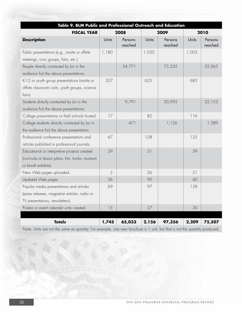
The 2011 Preserve America Progress Report32
Table 9. BLM Public and Professional Outreach and Education
FISCAL YEAR 2008 2009 2010
Description Units Persons reached
Units Persons reached
Units Persons reached
Public presentations (e.g., onsite or offsite
meetings, civic groups, fairs, etc.).
1,180 1,030 1,005
People directly contacted by (or in the
audience for) the above presentations.
54,771 75,235 52,065
K-12 or youth group presentations (onsite or
offsite classroom visits, youth groups, science
fairs).
327 625 685
Students directly contacted by (or in the
audience for) the above presentations.
9,791 20,995 22,153
College presentations or field schools hosted. 17 82 116
College students directly contacted by (or in
the audience for) the above presentation.
471 1,126 1,289
Professional conference presentations and
articles published in professional journals.
67 128 125
Educational or interpretive projects created
(curricula or lesson plans, kits, trunks, museum
or booth exhibits).
29 51 59
New Web pages uploaded. 5 26 21
Updated Web pages. 36 90 40
Popular media presentations and articles
(press releases, magazine articles, radio or
TV presentations, newsletters).
69 97 128
Posters or event calendar units created. 15 27 30
Totals 1,745 65,033 2,156 97,356 2,209 75,507
Note: Units are not the same as quantity. For example, one new brochure is 1 unit, but that is not the quantity produced.
The 2011 Preserve America Progress Report 33
National Landscape Conservation System 10th AnniversaryThe 10th anniversary of the NLCS in 2010 coincided
with the Society for American Archaeology’s (SAA’s)
75th anniversary celebration. The SAA is the nation’s
leading professional archaeological and heritage
education organization. At the SAA’s annual meeting
in St. Louis, Missouri, scientists and heritage educators
presented results of their research and programs, many
of which take place on public lands. This unique
opportunity gave the BLM an opportunity to highlight
some of their contributions:
• SAA Poster Session. An SAA poster session,
titled “Science, Challenges, and Conservation:
Managing Heritage Resources in the 21st
Century on BLM’s National Landscape
Conservation System” highlighted cultural
resource management and research at various
units of the NLCS, including the BLM’s use of
information technology research on Wyoming’s
national historic trails, and investigations on the
Paria Plateau at the Vermilion Cliffs National
Monument.
• SAA Symposium. The BLM also organized an
afternoon-long symposium entitled “Celebrating
a Decade of Discovery, Archaeology, Heritage
Education, and Outreach on the Bureau of Land
Management’s National Landscape Conservation
System.” The symposium included research on
New Mexico’s El Malpais National Conservation
Area, Mesita Blanca Wilderness Study Area, and
Eagle Peak Wilderness Study Area; the challenges
of finding and preserving historic trails in
southern Idaho and New Mexico; management
of sacred landscapes; and the restoration of the
Piedras Blancas Light Station in California.
Project ArchaeologyProject Archaeology is a joint program between the
BLM and Montana State University that has been
cultivating a stewardship ethic for cultural resources
through educational programming since 1990. In
the last 3 years, Project Archaeology has delivered
high-quality stewardship education materials and
professional development to 1,746 educators. We
estimate that these educators in turn reach 37,500
learners in classrooms, museums, and visitor centers
within 1 year of their introduction to Project
Archaeology.
Project Archaeology heritage education materials
introduce youth to historic preservation in the
classroom and in informal venues; enliven history
learning through investigation of authentic
archaeological data; and integrate historic preservation
into science, social studies, language arts, and
mathematics. Innovative, inquiry-based lessons help
youth understand the relationships between humans
and the natural world. Lessons expose students to
the NHPA and engage them in civic dialogue about
historic preservation issues. Learning research shows
that students’ commitment to stewardship increases
significantly from instruction with Project Archaeology
materials (see Figures 1 and 2).
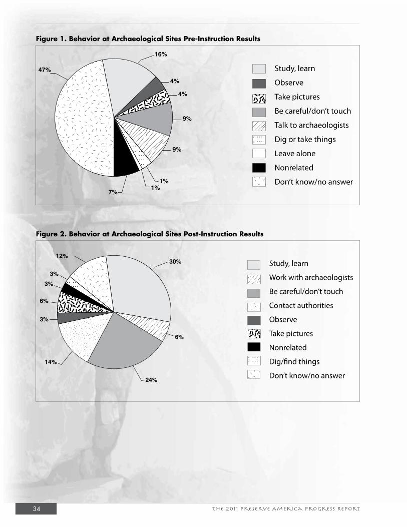
The 2011 Preserve America Progress Report34
Figure 1. Behavior at Archaeological Sites Pre-Instruction Results
Figure 2. Behavior at Archaeological Sites Post-Instruction Results
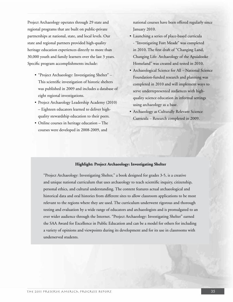
The 2011 Preserve America Progress Report 35
Project Archaeology operates through 29 state and
regional programs that are built on public-private
partnerships at national, state, and local levels. Our
state and regional partners provided high-quality
heritage education experiences directly to more than
30,000 youth and family learners over the last 3 years.
Specific program accomplishments include:
• “Project Archaeology: Investigating Shelter” –
This scientific investigation of historic shelters
was published in 2009 and includes a database of
eight regional investigations.
• Project Archaeology Leadership Academy (2010)
– Eighteen educators learned to deliver high-
quality stewardship education to their peers.
• Online courses in heritage education – The
courses were developed in 2008-2009, and
national courses have been offered regularly since
January 2010.
• Launching a series of place-based curricula
- “Investigating Fort Meade” was completed
in 2010. The first draft of “Changing Land,
Changing Life: Archaeology of the Apsáalooke
Homeland” was created and tested in 2010.
• Archaeological Science for All – National Science
Foundation-funded research and planning was
completed in 2010 and will implement ways to
serve underrepresented audiences with high-
quality science education in informal settings
using archaeology as a base.
• Archaeology as Culturally Relevant Science
Curricula – Research completed in 2009.
Highlight: Project Archaeology: Investigating Shelter
“Project Archaeology: Investigating Shelter,” a book designed for grades 3-5, is a creative
and unique national curriculum that uses archaeology to teach scientific inquiry, citizenship,
personal ethics, and cultural understanding. The content features actual archaeological and
historical data and oral histories from different sites to allow classroom applications to be most
relevant to the regions where they are used. The curriculum underwent rigorous and thorough
testing and evaluation by a wide range of educators and archaeologists and is promulgated to an
ever wider audience through the Internet. “Project Archaeology: Investigating Shelter” earned
the SAA Award for Excellence in Public Education and can be a model for others for including
a variety of opinions and viewpoints during its development and for its use in classrooms with
underserved students.
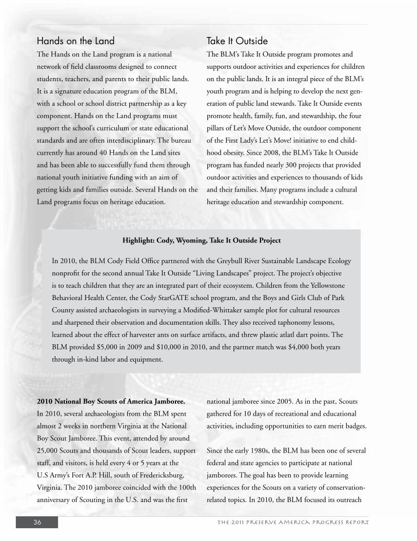
The 2011 Preserve America Progress Report36
Hands on the LandThe Hands on the Land program is a national
network of field classrooms designed to connect
students, teachers, and parents to their public lands.
It is a signature education program of the BLM,
with a school or school district partnership as a key
component. Hands on the Land programs must
support the school’s curriculum or state educational
standards and are often interdisciplinary. The bureau
currently has around 40 Hands on the Land sites
and has been able to successfully fund them through
national youth initiative funding with an aim of
getting kids and families outside. Several Hands on the
Land programs focus on heritage education.
Take It OutsideThe BLM’s Take It Outside program promotes and
supports outdoor activities and experiences for children
on the public lands. It is an integral piece of the BLM’s
youth program and is helping to develop the next gen-
eration of public land stewards. Take It Outside events
promote health, family, fun, and stewardship, the four
pillars of Let’s Move Outside, the outdoor component
of the First Lady’s Let’s Move! initiative to end child-
hood obesity. Since 2008, the BLM’s Take It Outside
program has funded nearly 300 projects that provided
outdoor activities and experiences to thousands of kids
and their families. Many programs include a cultural
heritage education and stewardship component.
Highlight: Cody, Wyoming, Take It Outside Project
In 2010, the BLM Cody Field Office partnered with the Greybull River Sustainable Landscape Ecology
nonprofit for the second annual Take It Outside “Living Landscapes” project. The project’s objective
is to teach children that they are an integrated part of their ecosystem. Children from the Yellowstone
Behavioral Health Center, the Cody StarGATE school program, and the Boys and Girls Club of Park
County assisted archaeologists in surveying a Modified-Whittaker sample plot for cultural resources
and sharpened their observation and documentation skills. They also received taphonomy lessons,
learned about the effect of harvester ants on surface artifacts, and threw plastic atlatl dart points. The
BLM provided $5,000 in 2009 and $10,000 in 2010, and the partner match was $4,000 both years
through in-kind labor and equipment.
2010 National Boy Scouts of America Jamboree.
In 2010, several archaeologists from the BLM spent
almost 2 weeks in northern Virginia at the National
Boy Scout Jamboree. This event, attended by around
25,000 Scouts and thousands of Scout leaders, support
staff, and visitors, is held every 4 or 5 years at the
U.S Army’s Fort A.P. Hill, south of Fredericksburg,
Virginia. The 2010 jamboree coincided with the 100th
anniversary of Scouting in the U.S. and was the first
national jamboree since 2005. As in the past, Scouts
gathered for 10 days of recreational and educational
activities, including opportunities to earn merit badges.
Since the early 1980s, the BLM has been one of several
federal and state agencies to participate at national
jamborees. The goal has been to provide learning
experiences for the Scouts on a variety of conservation-
related topics. In 2010, the BLM focused its outreach
The 2011 Preserve America Progress Report 37
on four topics: speleology (caves), paleontology (fossils),
fire safety, and archaeology. The BLM was assigned a
special area along the Conservation Trail, which loops
about 1/2 mile through a forested area on Fort A.P.
Hill. As in past years, the BLM provided a hands-on
educational experience involving archaeology for more
than 6,500 Scouts, Scout leaders, staff, and families.
The archaeology exhibit involved Scouts completing
the construction of a circular, semi-subterranean
structure called a pithouse that was modeled after
one at the BLM’s Canyons of the Ancients National
Monument.
Finding History’s Forgotten People Project. The
BLM has been working with students and faculty
from Coppin State University on the continuation of
a research project initiated in 2006 called “Finding
History’s Forgotten People.” This project documents
the impact of minorities in the development of the
western portion of the United States. The project is
based on the premise that the experience of African
Americans has been largely excluded from accounts
that chronicle the history of the West’s development.
As a result, the project provides an opportunity to
fully understand and appreciate the breadth and depth
of the African American experience in shaping the
United States. The Coppin research team set out to
produce research that would help the BLM create a
more inclusive narrative regarding the management
of public lands, and education of the public at large,
by providing historical research relative to the role of
African Americans in the shaping of this country.
In their first phase, the Coppin research team focused
their attention on the state of Colorado. Their research
resulted in an in-depth and thorough study of Afri-
can Americans in the development of that state, with
emphasis on geographic areas near or adjacent to BLM
lands. During several weeks of extensive research, the
Coppin research team uncovered vast amounts of little
known, but pertinent and highly valuable, information
relative to the role of African Americans. At the conclu-
sion of their research, the Coppin students and faculty
produced a detailed map of Colorado that specifies areas
where African Americans were prominent in the state’s
development. They also produced an extensive reader,
titled “Finding History’s Forgotten People: The Presence
of African Americans in the Settlement of Colorado, c.
1534 to 1954.” In this reader, the researchers addressed
the role of Colorado’s African Americans in areas such as
mining, building communities, cattle ranching, and en-
trepreneurship. The more than 100-page reader provides
detailed accounts of individual African Americans, the
struggles they faced and overcame, their successes as well
as failures, and their overall input into early Colorado
society.
Since 2008, the Coppin research team has been focus-
ing on the state of Oregon. The student researchers have
begun doing preliminary research that will culminate
in a similar detailed map that will specify areas where
African Americans played important roles in the shaping
of that state. They also will produce a reader, which,
like the Colorado reader, addresses the role of Oregon’s
African American community in several key areas.

The 2011 Preserve America Progress Report 39
VIII. Exemplary PartnershipsIncorporating partners and volunteers into the stewardship of the BLM’s historic properties is a
key component of Executive Order 13287 and results in enhanced use and protection. The BLM’s
partnerships are typically developed for stabilization, interpretation, inventory, rehabilitation,
curation, and site stewardship projects. Partners include nonprofit organizations, professional
organizations, “friends of” organizations, museums, Indian tribes, universities, and more. These
partnerships are a critical component of managing cultural resources on public lands. Not only
do they provide funding and in-kind contributions, which are essential ingredients for successful
preservation projects, but they also establish coalitions that emphasize the importance of these
resources to the public. Because many of the partnerships are locally based, they also strengthen the
bond that local communities have with public lands, and they build local constituent support. The
2011 Preserve America Progress Report emphasizes youth project partnerships, tribal partnerships,
heritage tourism partnerships, and the BLM Cultural Resources Data Sharing Partnership.
Youth Project PartnershipsAlaska: University of Alaska Museum Collections Youth Partnership Work. The University
of Alaska’s Museum of the North and Archaeology Department curates BLM archaeological
collections from all over the State of Alaska. The BLM has 1,326 accessioned collections at the
museum, and of the estimated 500,000 to 700,000 artifacts present in these collections, only about
140,000 have been either cataloged or inventoried in any manner. In addition, the University
of Alaska’s Earth Sciences Department has the largest collection of fossils in Alaska, including
Cretaceous dinosaurs and ice age mammals. About one-third to one-half of these collections come
from BLM-managed land, or an estimated 10,000-30,000 specimens from 1,000 localities (l,140
separate accessions). The BLM has assistance agreements with both the University of Alaska’s Earth
Sciences and Archaeology Departments to bring BLM-owned collections up to modern curation
standards.
University graduate and undergraduate students form the backbone of the workforce addressing
these dire needs. Student assistants receive training and supervision from a professionally trained
archaeological collections manager and a curator/professor. Three important goals are being met:
(1) hands-on training for students who will be the next generation of Alaskan archaeologists or
who will staff the increasing number of local museums and heritage centers around the state; 2)
The 2011 Preserve America Progress Report40
preservation of these collections for future generations;
and 3) incorporation of the material into collections
databases on an object-by-object basis, which allows
the museum to distribute images and information
about the collections via the Internet. This last goal is
particularly important in Alaska where the population
is highly dispersed and opportunities to visit museums
are limited.
Alaska: Campbell Creek Science Center Youth
Education Project. The BLM Anchorage Field
Office, through its management of the Campbell
Creek Science Center, has had an important role in
engaging youth in the outdoors in Anchorage. Through
educational programs with the Anchorage School
District; Trailside Discovery Camps in the summer; and
events such as Outdoor Week, National Public Lands
Day, and the Iditarod Trail Sled Dog Race, the BLM
teaches Anchorage youth about stewardship of cultural
and paleontological resources on public lands using the
science center and the Campbell Tract Facility, a 700-
acre parcel of BLM land in east Anchorage.
Evening lectures at the science center are attended
by adults and families and have featured topics such
as prehistoric sites in the Aleutian chain, mammoth
extinction, and dinosaur fossils found on BLM-
managed lands along the Colville River. The Iditarod
ceremonial start at the Campbell Creek Science Center
features exhibits about the history of the Iditarod
National Historic Trail and has drawn thousands of
people in 2010 and 2011, and a booth on the Iditarod
Trail at the 2010 Alaska State Fair extended the
educational opportunities beyond the science center
itself. To indirectly reach more youth, the Campbell
Creek Science Center staff works with Alaska teachers
through the iTREC! Program (Iditarod Trail to Every
Classroom) by educating teachers across Alaska about
how to make the Iditarod National Historic Trail a part
of their curriculum.
In FY 2010 alone, the Campbell Creek Science Center
made contact with more than 800 K-12 youth in
programs that relate to cultural and paleontological
resources. Added to that are the hundreds of students
taught about the Iditarod National Historic Trail by
teachers enrolled in the iTREC! program and the
hundreds of youth reached at offsite locations like the
Alaska State Fair.
Arizona: Native American Youth Historic
Preservation Internship Program. The Grand
Canyon-Parashant National Monument is jointly
administered by the National Park Service (NPS) and
the BLM-Arizona Strip Field Office. The two agencies
recently instituted an initiative which combines heritage
resource education with recruitment of American
Indian interns for the Native American Youth Historic
Preservation Internship Program. The program began
in July 2010 and currently employs four interns and
a crew chief. All interns and the crew chief are tribal
members from northern Arizona and southern Utah.
Funding for the project came from both NPS and
BLM youth incentive/initiative programs. BLM and
NPS personnel presented the project to the Southern
Paiute Tribal Chairpersons Association, which included
representatives from the Kaibab Band of Paiute Indians,
the Paiute Indian Tribe of Utah, and the Moapa Band of
Paiute Indians. The Southern Paiute Tribal Chairpersons
Association was asked for their assistance in identifying
potential candidates and has been of great help in
implementing the project.
The internship program’s first project included a series
of structural repairs to the boarding house at the Grand
Gulch Mine, a historic copper mining complex on
The 2011 Preserve America Progress Report 41
BLM land that operated from 1874 until about 1955.
The boarding house’s deteriorating roof problems
had caused the sloughing of the exterior wall mortar
in multiple sections. Interns first participated in a
historic preservation training program taught by the
NPS Western Center for Historic Preservation and
then began work at the Grand Gulch historic site.
Repair needs and priorities were assessed with NPS and
BLM personnel, and the internship crew completed
stabilization of the boarding house structure. Repairs
of the walls and repointing of the masonry were
completed by the end of the 2010 work season. Very
little of the original fabric required replacement, and the
waterproofing and sealing of the roof will substantially
extend the life of the structure.
Colorado: Preserve America Youth Stewards.
Colorado students and Hopi youth became stewards
of southwest Colorado during a summit aimed at
capturing youth interest in public lands. The 2009
Preserve America Youth Summit was hosted at the
BLM Anasazi Heritage Center as part of the Take it
Outside! program and sponsored by the Colorado
Preservation, Inc., Colorado Historical Society, State
Historical Fund, Colorado Humanities, Colorado West
Tourism Council, Crow Canyon Archaeological Center,
NPS, U.S. Forest Service (USFS), and BLM. More
than 125 students, teachers, and sponsors participated
in the 4-day event to study both ancient peoples of the
southwest and modern preservation issues, including
input on how the areas can be managed and how
to attract youth. Summit participants were chosen
through a competitive statewide application process
based on geographic and cultural demographics,
involvement in preservation activities, and ability to
followup in their community.
By participating in educational activities and visiting
some of the nation’s premiere archaeological treasures
at the Anasazi Heritage Center and Canyons of the
Ancients National Monument, Ute Mountain Tribal
Park, Mesa Verde National Park, and sites in San Juan
National Forest, participants:
• Learned about the multifaceted field of
archaeology through visits to sites, laboratories,
curation facilities, and meetings with
archaeologists;
• Learned about the ancestral Native American
people who occupied the region;
• Learned about the role heritage tourism can play
in balancing cultural sensitivity with impacts to
cultural resources and contributions to economic
vitality; and
• Developed recommendations and products to
raise preservation awareness for the region.
Eastern States: 1880s Camp at Winterville Mounds
Park. The BLM sponsored an 1880s “camp” as part
of the second annual Mississippi Archaeological
Association Exposition at the Winterville Mounds
Park, administered by the Mississippi Department of
Archives and History. The exposition drew more than
3,000 visitors who were given tours of the mounds in
addition to demonstrations on stick ball, atlatl use,
and flint knapping. In addition, the BLM participated
in the 2010 Bankhead Archaeology Festival at Brushy
Lake Campground in Alabama, which drew 350
children (with their families) to enjoy demonstrations
and events celebrating life in the 19th century,
including programs on archaeology, ethnography, and
local history.
Idaho: Cooper’s Ferry Field School. This CCS
partnership and youth project with Oregon State
University began in 2009 and continued in 2010.
Students from all over the United States participated
in the field school hosted by the Cottonwood Field
The 2011 Preserve America Progress Report42
Office at Cooper’s Ferry, located in the lower Salmon
River canyon of western Idaho. The 1997 Oregon
State University excavations at the Cooper’s Ferry site
revealed a long record of repeated human occupation,
beginning with a Western Stemmed Tradition
assemblage associated with radiocarbon dates (using
carbon-14) of A.D. 11,370 and 11,410. The university
is currently building upon the information collected
already and is seeking to address many archaeological
questions related to the evolution of technology,
economic patterns, and environmental conditions
during the late Pleistocene to early Holocene period.
The university has contributed more than 7,500 hours
of volunteer time in 2010 in the field alone. Funding
provided through the youth initiative allowed one
student to complete public interpretation efforts for
the Cooper’s Ferry website. Very positive responses
were received from the public, and there have been
more than 1,200 hits on the site from 42 states
and 28 different countries. The Nez Perce Tribe is a
partner in the project, and a well-received presentation
summarizing the work was given to the Nez Perce Tribe
Natural Resources Subcommittee.
Montana: Bridging the Divide, 2009. The Bridging
the Divide Natural and Cultural Resources Field Camp
is jointly sponsored by the USFS Beaverhead-Deerlodge
National Forest and the BLM Dillon Field Office. By
teaming students with tribal elders, the goal of the
program is to develop a formal educational curriculum
in partnership with Shoshone-Bannock and Salish
and Kootenai Tribes that places equal emphasis on
outdoor experience and scientific exploration to expand
cultural heritage awareness. The 2010 field camp
was based at the University of Montana Birch Creek
Outdoor Education Center on the Dillon District of
the Beaverhead-Deerlodge National Forest. This year’s
camp involved students from the Shoshone-Bannock
Jr./Sr. High School and tribal elders from Fort Hall,
Idaho. Educational activities focused on understanding
cultural landscapes and the tribal traditions associated
with camas/wet meadow ecology of southwestern
Montana. Activities included: (1) an overview of
the prehistory, history, and tribal use of the area; (2)
learning traditional skills, such as making wooden
digging sticks from native mountain maple, bark bags
from lodgepole and fir trees, and cordage from dogbane
fibers; (3) harvesting and baking camas (a traditional
food); and (4) understanding the ecology of camas/
wet meadow environments by conducting vegetative
transects and digging soil pits.
Nevada: Lovelock Cave Youth Event. To celebrate
Historic Preservation Month, the BLM Winnemucca
District Office and Nevada Outdoor School host a
4-day event at Lovelock Cave, which is listed on the
National Register and is located near Lovelock. More
than 400 fourth-grade students from local schools
participate in tours and activities at the cave and at the
Marzen House Museum in Lovelock. Presentations
are given at 12 stations, including topics such as
archaeology, the Paiutes, ethnobotany, the emigrant
trails, geology, mining and assaying, the Civilian
Conservation Corps, and the history of Lovelock
Cave. The objective of the field trip is to instill a sense
of respect and stewardship for cultural and natural
resources on the public lands. Other partners include
the Humboldt and Pershing County School Districts
and the Geological Society of Nevada.
New Mexico: Mesa Prieta Petroglyph Project. In
the summer of 2010, for the ninth straight year, the
BLM Taos Field Office worked with Vecinos del Rio,
a nonprofit group, on a 2-week petroglyph recording
project on public lands on Mesa Prieta near Velarde,
The 2011 Preserve America Progress Report 43
New Mexico. Vecinos del Rio recruited and trained
local teenagers to record rock art. The students were
signed up as BLM volunteers and supervised by a BLM
archaeologist and other adult members of Vecinos
del Rio and the Taos Archaeological Society. Students
included Native Americans from the Ohkay Owingeh
Pueblo, as well as youths from Velarde, Dixon, and
Espanola. On the first day of field work, the group
visited the large prehistoric pueblo of Posi-Ouinge
along the Rio Ojo Caliente and recorded three panels
of petroglyphs near the site. Posi, which has more than
2,000 rooms, is an ancestral Tewa pueblo inhabited
during A.D. 1300-1600. The youths used global
positioning systems, digital photography, and extensive
written documentation to record roughly 50 panels of
petroglyphs that they discovered during the inventory.
Data recorded during the project has been entered into
a geographic information system database that will
become a powerful tool for data curation and research.
Oregon/Washington: Investigations of Early Human
Settlement of the Northern Great Basin (Burns
District). Since 2008, the BLM Burns District Office
and partners have engaged more than 60 youth in a
number of diverse archaeological investigations of late
Pleistocene to late Holocene human occupations and
use in Oregon’s high desert country. Partners include
the University of Oregon, University of Wisconsin, and
Oregon Archaeological Society.
The youth consist primarily of undergraduate- and
graduate-level students enrolled in the University of
Oregon’s Archaeological Field School and participating
in the University of Wisconsin’s ongoing archaeological
research project on Steens Mountain. Field schools
typically encompass a 6-week period. At least two
students are pursuing graduate degrees based on the
investigations. Others have volunteered their time
through the Oregon Archaeological Society’s programs.
As the programs are led by professional archaeologists,
geoarchaeologists, and other researchers from the
universities and the BLM, students are offered a
unique opportunity to gain valuable experience in a
number of activities that will serve them in their career
development and pursuits.
Oregon/Washington: Reaching Out to the Youth
of Southwest Oregon. From 2008 through 2010,
the BLM Roseburg District sponsored/participated
in several public outreach activities involving local
school children. Programs included a school forestry
tour, creek week day camp, the McGovern Elementary
School outdoor school program, and Camp Two-Way
Seeing (presented at the Applegate House). The school
forestry tour provides an outdoor learning center for
sixth graders and is a cooperative effort among the
BLM, Douglas County, the USFS, and private industry.
Activities at the school forestry tour and other programs
included artifact replica presentations, question and
answer sessions with archaeologists, and atlatl throwing.
Between 2008 and 2009, more than 1,100 students,
teachers, and parents participated.
Oregon/Washington: Sage Hen Gap Clovis Site.
Between 2008 and 2010, the University of Oregon has
conducted research at the Sage Hen Gap Clovis Site,
which is estimated to be about 12,500 years old. Field
school students intensively mapped, conducted test
excavations, and gained instruction in geoarchaeology
research techniques. Situated in an upland setting, 12
Clovis period spear points were recovered. The site is
believed to be part of a system of ancient big game kill
sites. Geoarchaeology studies in the area are focused
on identifying late Pleistocene to early Holocene
sediments/deposits suitable for containing ancient
cultural materials.

The 2011 Preserve America Progress Report44
Oregon/Washington: Sheep Mountain Site.
Between 2008 and 2010, the University of Oregon
Archaeological Field School conducted test excavations
at the Sheep Mountain Wilderness Study Area, which
includes a Clovis occupation estimated to date back
12,500 years ago. In 2008, students participated in
backhoe trenching, excavating auger probes, and
test excavation units. Excavations revealed a Mount
Mazama volcanic ash deposit and four to six well-
developed soils below the ash. Artifacts have been
found in large numbers below the ash, and it appears
that this site is a good candidate for continued research
into the most ancient occupants of southeastern
Oregon. Three Clovis spear points and two fluted
bifaces have been identified at the site. Their estimated
age, using the obsidian hydration dating technique,
is 12,500 years old. Geoarchaeology analyses also
identified a discrete soil containing metallic particles
that may be associated with a comet explosion believed
by some researchers to be associated with the Younger
Dryas cold period (approximately 11,900 to 12,900
years ago). Additional analyses are ongoing, and
researchers plan to investigate climatic changes through
the site’s paleoenvironmental record. Several hundred
hours of volunteer labor have been donated by the
Oregon Archaeological Society.
Oregon/Washington: Roaring Butte Site. Doctoral
candidates, students from the University of Wisconsin,
and volunteers from the Oregon Archaeological
Society completed survey, collection, and mapping
of an early to middle Holocene encampment near
Steens Mountain on the BLM Burns District in 2008.
Later in 2010, the University of Wisconsin returned
and conducted archaeological excavations at the site
exposing a living surface dating to approximately
6,000 years ago. The site contains a number of features
interpreted to be wickiup-type living structures, a
midden deposit, hearths, and faunal remains.
Oregon/Washington: Clovis Quest Inventory.
Between 2008 and 2010, the Oregon Archaeological
Society members and other local volunteers worked
with BLM Burns District archaeologists inventorying
2,500 acres of BLM lands and recording several new
archaeological sites—some of which produced Clovis
and Western Stemmed Tradition projectile points
dating to more than 11,000 years ago. In addition,
more than 60 chipped stone “crescent” artifacts—a
stone tool particularly unique to the Great Basin—were
documented during 4 weeks of survey. One student is
pursuing master’s thesis research based on the crescents.
Oregon/Washington: Catlow Valley Inventory and
Site Evaluations. University of Oregon Archaeological
Field School students and Oregon Archaeological
Society volunteers completed 1,600 acres of
archaeological inventory in Catlow Valley recording 22
new sites. A graduate student is analyzing prehistoric
human settlement patterns of Catlow Valley and
contrasting these with the human settlements at Fort
Rock Valley to the west. The students also excavated
a narrow test trench in a newly described rock shelter
in Catlow Valley. A graduate student will analyze
the sediments for paleobotanical remains as part of a
master’s thesis.
Utah: Utah Family Hikes. The BLM Kanab Field
Office continued field trips for the public with their
Amazing Earthfest hike to the Mansard, a locally
well-known rock art site, and their Family Discovery
Caravan hike to South Fork Indian Canyon. The hike
into South Fork is short and relatively easy, but the hike
into the Mansard is a much longer and more strenuous
The 2011 Preserve America Progress Report 45
affair involving a climb to the top of the Vermilion
Cliffs and several miles of hiking over unprepared
trails. However, this was a great success and involved
members of the public whose ages ranged between
about 20 years old to one gentleman well into his 70s.
Utah: Kanab Field Office Boy Scout Stewardship
Project. A site in South Fork Indian Canyon is a locally
well-known rock art site of striking Basketmaker II time
period pictographs in a large rock shelter overlooking
the canyon below. Looting episodes in the early 1970s
led to the placement of a chain link fence across the
entrance to the shelter. Over the years, visitors had par-
tially torn down the fence as they climbed over to access
the rock art panel. Monitoring and inspection showed
that people were crossing the fence to get a closer look
and photograph the panel. The panel was almost com-
pletely free of vandalism and graffiti, so BLM volunteers
and backcountry staff removed the fence in 2009. In
2010, a local Boy Scout troop planned and constructed
a boardwalk within the shelter as one scout’s Eagle Scout
project. The boardwalk allows close inspection of the
rock art, but encourages visitors to stay on the board-
walk and not disturb the remains of the archaeological
site on the shelter floor. Frequent monitoring indicates
that so far the boardwalk is a success and that the rock
art panel remains free of vandalism. By removing the
fence and allowing visitors to “do the right thing,” the
Kanab Field Office is experimenting with responsible
public access, and the results are encouraging.
Utah: Hands on the Land Program. During the
third week in June 2010, 21 students from Enoch
and Three Peaks Elementary Schools participated
in a Hands on the Land archaeological day camp.
Camp activities consisted of artifact identification,
archaeological methods, American Indian crafts, site
recording, and photography. The main activity of the
camp was excavating looted backfill from two rock
shelters and then moving it back into the rock shelters.
Five fifth-grade boys at the camp earned their Boy
Scouts archaeology and photography merit badges. The
camp was led by staff from the BLM Cedar City Field
Office, USFS Dixie National Forest, and Three Peaks
Elementary. Funding for this camp came from the
youth initiative.
Wyoming: Kansas State School for the Blind
Students Take on the Rocky Mountains at South
Pass. Seventeen students from the Kansas State School
for the Blind literally followed in the footprints left
by the pioneers of two centuries past. As one facet
of a 3-week experience called the Discovery Trail,
the students took on the challenge of crossing the
continental divide using talking global positioning
satellite units which provide the user with detailed
directions as well as interpretive materials. They are the
prototypes of new technologies that will aid the visually
impaired with experiencing the great outdoors without
the need for human guides. Initially, the students got
off to a rough start. However, once they began using
the system according to directions, they were able to
adeptly navigate the trail and find their way to the
summit of the Rocky Mountains on public lands
managed by the BLM Rock Springs Field Office.
Tribal PartnershipsThe BLM consults, coordinates, and cooperates with
tribal governments in managing those resources of
particular concern to American Indians. In addition,
the BLM has formed specialized partnerships with
tribal governments, organizations, and traditional
practitioners to advance specific programs and
objectives; to protect significant sites, resources, and
values important to the American Indian community;
and to assist in inventory areas important to tribes.
The 2011 Preserve America Progress Report46
Alaska: Glennallen Tribal Consultation Agreements.
The BLM Glennallen Field Office began creating
agreements with federally recognized tribes in 2003
as part of an effort to consult on the east Alaska RMP
in 2004 and to discuss the location and concerns
surrounding any places of religious and cultural
importance. Today, the BLM has nine memorandums
of understanding with tribes in and around the Copper
River Basin. Participating tribes include the Cheesh’na
Tribe, Native Village of Eyak, Yakutat Tlingit Tribe,
Native Village of Gakona, Native Village of Tazlina,
Gulkana Village Council, Native Village of Chitina,
Chickaloon Native Village, and Mentasta Traditional
Council. These agreements have now expanded to
include annual meetings between the BLM and tribes
to consult on issues, projects, and proposals that have
the potential to affect tribes or their cultural interests
and have improved the relationships between the
Glennallen Field Office and the federally recognized
tribes in the region. BLM employees and tribal council
members have established a rapport with friendly and
frank discussions on a variety of tribal issues. The
meetings have also allowed the Glennallen Field Office
to present itself as a representative of the BLM to tribal
council members, who were confused by different
federal agencies and their missions.
Alaska: Red Devil Mine Tribal Consultation. This
example describes successful consultation with various
tribes along the lower reaches of the Kuskokwim
River concerning cleanup efforts for a former mine
in the vicinity of the Village of Red Devil. The BLM
Anchorage Field Office has been proactively working
to improve its tribal consultation policy for several
years. The field office has more than 100 federally
recognized tribes within its boundaries and more than
40 tribes that are routinely consulted with regard to
proposed projects. Most of these tribes are located in
small communities in rural Alaska, accessible only by
airplane, so consulting appropriately creates unique
logistical and financial challenges. The need to consult
not only with federally recognized tribes, but also with
village and regional Native corporations in accordance
with the Alaska Native Claims Settlement Act, is an
additional challenge unique to Alaska. The Anchorage
Field Office is currently working extensively with Native
communities along the Kuskokwim River on projects
related to cleanup of the Red Devil Mine. Native
Alaskans and other rural residents are concerned about
impacts the mine had, and continues to have, on the
water quality and health of animals, including salmon,
in the Kuskokwim River drainage.
Arizona: Statewide Tribal Relations Strategy. BLM-
Arizona has instituted a number of measures over the
last 3 years that have improved relations with tribes
throughout the state. Due to recent efforts of BLM staff
and managers, tribes are being asked for their viewpoints
more regularly, communications are improving, and
decisionmakers are working together more often to
identify and solve problems of mutual concern. These
improved relations stem from the development of a
statewide tribal relations strategy, as well as improved
recognition by BLM personnel of the differences
between government-to-government relations and
project-specific staff work. BLM-Arizona is taking
time to ensure tribes are heard, tribes understand how
and why the BLM makes certain decisions, and tribal
viewpoints are considered in those decisions. Specific
recent BLM accomplishments include:
• Development of a statewide Arizona Tribal
Relations Strategy (a draft can be found at http://
www.blm.gov/az/st/en/info/strategies.html) that
places tribal relations at the highest level of state
planning initiatives.
The 2011 Preserve America Progress Report 47
• Development of a statewide Arizona Heritage
Resources and Community Stewardship Strategy
that recognizes the unique place tribes have in the
multicultural landscape and history of Arizona.
• Increasing the number and frequency of person-
to-person meetings between BLM staff and
their tribal counterparts, as well as increasing
the number and frequency of person-to-person
meetings between BLM managers and elected
tribal officials.
BLM-Arizona has also made more general
improvements in tribal consultation, including:
• Broadening the scope of consultation and
coordination efforts by including tribes in long-
term planning efforts as well as shorter-term,
project-specific undertakings.
• Providing increased opportunities for tribes to
learn more about broadscale BLM initiatives,
such as renewable energy development, in
workshop settings that are not focused on single
projects.
• Working more closely with tribal staffs and
elected leaders to ensure tribal views are gained
and considered when developing alternatives.
Colorado: Perspectives on Ute Ethnohistory in
West-Central Colorado (2008-2010). This landscape
study was initiated by the BLM in collaboration
with the Grand Mesa, Uncompahgre, and Gunnison
National Forests; Colorado National Monument;
Dinosaur National Monument; Museum of Western
Colorado; Mesa State College; Colorado State
University; Mesa County; the Colorado Council on
the Arts; and Dominguez Archaeological Research
Group. In collaboration with the Southern Ute Indian
Tribe, Ute Mountain Ute Tribe, and Ute Indian Tribe
of the Uintah and Ouray Reservation, this project
supports the RMP for the Glenwood Springs, Grand
Junction, and Uncompahgre Field Offices. The
following broad goals and objectives were defined:
(1) the project should be for the benefit of all Utes,
not just certain tribes or bands; (2) the project should
recognize that Ute culture is a living heritage, and
cultural resource protection and preservation is a way
to connect past and future; (3) the project should
recognize that Ute cultural resources include not
just archaeological sites, but also their relationship
to land and natural resources; (4) the project should
seek ways to include Ute young people working on
the land together with Ute elders and families; and
(5) the project should consider and fully explore all
appropriate resource management designations in
developing management recommendations for the
project report. All participants acknowledged the
importance of trying to work together on a more
fundamental, personal level that may be able to bridge
differences between the organizations and members of
different cultures.
Ute heritage sites and general areas of Ute cultural
interest were identified in each field office. Field
visits occurred with tribal representatives to identify
these cultural, traditional, and religious locations.
Many locations have either not been disclosed by
the elders of the tribe and subsequently have been
lost to younger generations, or they have been lost
through the processes of acculturation. The visits
provided opportunities for Utes to collect fragments
of cultural memories and record current feelings of
tribal members for the lands that were their traditional
The 2011 Preserve America Progress Report48
homelands. The field visits were supported by
additional information from archival and bibliographic
sources. Some recorded Ute ethnographic material had
never been transcribed, processed, or reported. This
information ranges from original notes and recordings
to “gray” literature reports. The ethnohistory was
completed in 2010.
Colorado: “Visit with Respect” Film. This is a col-
laborative effort between the Canyons of the Ancients
National Monument, San Juan Mountains Association,
and Crow Canyon Archaeological Center. The Colorado
Historical Society’s State Historical Fund and the BLM
provided funding. The video’s intergenerational cast fea-
tures tribal members from Acoma Pueblo, Santa Clara
Pueblo, and the Hopi Tribe. Throughout the video,
they stress the living connection between ancestral vil-
lages and the modern-day descendants of the people
who built them and explain why everyone should visit
archaeological sites with respect. In honor of its 75th
anniversary in 2010, the Society for American Archaeol-
ogy, the nation’s leading professional archaeological asso-
ciation, held its first-ever film festival. The BLM’s “Visit
with Respect” was one of four winners of the film festi-
val. The film previously received the Caroline Bancroft
History Award from the Colorado Historical Society as
an outstanding project that made a major contribution
to the advancement of Colorado history. The film is
shown regularly at the Anasazi Heritage Center, Crow
Canyon Archaeological Center, and the Acoma Pueblo-
Sky City Cultural Center and Ha’aku Museum.
Eastern States: Traditional Cultural Property
Evaluation. The BLM Milwaukee Field Office com-
pleted a traditional cultural property evaluation for a
60-acre tract of public domain land in north-central
Wisconsin through an obligation of $30,000 of BLM
funds and a 100 percent match from a partnership with
the Lac du Flambeau Band of Lake Superior Ojibwe
and the University of Wisconsin-Madison. The BLM’s
tract is surrounded by an extensive bed of native wild
rice, which has been harvested by the local band of
Ojibwe for nearly 200 years. Ethnohistorical interviews,
archival research, and archaeological field investigations
provide a more complete picture of traditional Ojibwe
wild rice gathering from this location. This research has
demonstrated an enduring cultural, historical, and con-
temporary connection to this tract by the local Native
American community. The property was found to be
eligible for inclusion on the National Register. Tribal
outreach and consultation continued with the formal-
ization of a memorandum of understanding with the
Lac du Flambeau Band of Lake Superior Ojibwe and a
local landowner to protect and preserve these traditional
resources.
New Mexico: Ethnographic and Archaeological
Inventory with the Mescalero Apache Tribe of
Potential Traditional Cultural Properties in the
Vicinity of the Permian Basin, 2009-2010. An
archaeological and ethnographic inventory of nine
cultural locations in Eddy County, southeastern New
Mexico, on selected BLM lands within the BLM
Carlsbad Field Office is being prepared in cooperation
with the Mescalero Apache Tribe. The project was
funded by the Permian Basin MOA working group
with Permian Basin MOA funding.
Although the present-day Mescalero Apache
Reservation is restricted to a small part of northern
Otero County, New Mexico, the Mescalero Apache
aboriginal territory encompassed most of southeastern
New Mexico, portions of west Texas, and extended into
northern Mexico. The ethnographic cultural location
inventory was done in three phases: (1) reconnaissance
of potential locations for further intensive inventory;
The 2011 Preserve America Progress Report 49
(2) intensive inventory of cultural locations and
recording of vegetation, location characteristics, and
archaeological sites; and (3) Mescalero Apache elder
site visits to the nine cultural locations. To conclude
the project, TRC produced a report and site forms
documenting the nine cultural landscapes investigated.
The project resulted in insights about Mescalero use
of the landscape and lessons learned that will inform
future efforts.
Oregon/Washington: Archaeological Site
Stabilization, NAGPRA Compliance, and BLM-
Tribal Cooperation in Washington’s San Juan
Islands. The San Juan Islands, including those portions
managed by the BLM, are the ancestral home of people
whose descendants are affiliated with the Samish Indian
Nation, Swinomish Indian Tribal Community, Lummi
Nation, and other Native American tribes. Cultural
properties associated with these indigenous peoples,
including burial locations, are subject to a variety of
threats, and the BLM Spokane District collaborates
with tribes to protect cultural properties and burials
while protecting sensitive site location information.
In 2004, the BLM, Samish Indian Nation, and
University of Washington’s Burke Museum of Natural
History and Culture launched a cooperative project to
stabilize an important archaeological site situated in
an island bay from advancing erosion, while providing
public education with local partners and community
organizations. Stabilization measures designed by BLM
engineers were implemented, but unfortunately, strong
winter storm surges in Puget Sound compromised the
stabilization measures and eroded a portion of the site.
Temporary stabilization measures were implemented
in 2007 and 2008 until additional long-term
measures could be implemented. In 2009, remains
were discovered along the beach edge in a previously
stable location of the site, and temporary stabilization
measures were extended to this new location. Following
examination by the state’s physical anthropologist,
NAGPRA consultation with potentially affiliated tribes,
and preparation of required notices, the Swinomish,
Samish, and Lummi all filed claims with the Spokane
District to have the remains returned to their custody.
The BLM consulted with all three tribes, and following
consultation, the tribal governments agreed to a joint
claim and repatriation. Newspaper notices indicated
the BLM’s intent to transfer custody jointly to all three
groups, and no further claims were received.
In 2010, with the recent change in BLM policy
allowing reburial of NAGPRA remains on public lands,
the Spokane District requested approval from the BLM
assistant director to rebury the remains on public lands.
In one of the first reburial cases, the assistant director
approved the request. Pending a final schedule in
consultation with the tribes, the remains from the site
will be reinterred in a stable location near the site.
Heritage Tourism PartnershipsAlaska: Eagle Heritage Tourism Partnership. The
BLM-Alaska Eastern Interior Field Office has an
ongoing successful relationship with both the Eagle
Historical Society and Museums and the NPS to
provide tours, maintenance, and facility management
of the Fort Egbert National Historic Landmark. The
historic fort is named for U.S. Army Brigadier General
Harry C. Egbert, a Civil War veteran who became a
noted career military officer before being killed in Cuba
during the Spanish-American War. The historic fort is
the only 19th century fort still standing in Alaska and
is part of the Eagle Historic District in Eagle, Alaska.
Eagle, with gold rush and even earlier roots, is located
along the Yukon River downriver from Dawson in
Canada. It was established in the late 1890s, with the
The 2011 Preserve America Progress Report50
Army soon constructing a military fort there in 1898
and operating it into the early 1900s. Presently, the
once-thriving boomtown of Eagle is a community of
fewer than 100 year-round residents, although the
summer resident population includes several hundred
more. In addition, several thousands of tourists visit
Eagle and Fort Egbert each year by bus or boat. Over
the years, Eagle has become a notable tourist destination
in Alaska and is considered one of the state’s most
interesting and charming gold rush-era attractions, in
part because of the enjoyable and educational tours.
The Eagle Historical Society and Museums contributes
to the tours on the BLM-managed historic site of Fort
Egbert, and the BLM provides a staff member to help
with tours for the society and museum units outside
of BLM management, in addition to the facilities at
Fort Egbert. The remaining buildings of Fort Egbert
currently house historic displays, including relics from
the community of Eagle. The Eagle Historical Society
and Museums works with the BLM to provide exhibits
in some of the five standing buildings, including an
exhibit on restoration efforts on the fort. As tour
buses and independent travelers come into Eagle,
the partnership provides a comprehensive historical
overview of the area regardless of agency jurisdiction.
In 2010, Eastern Interior Field Office staff brought in
eight youth volunteers to gravel and refurbish nearly
3 miles of multiple-use trails, including the Hospital
Ruins Trail and Water Line Trail. These youth spent
3 weeks in the community of Eagle, including
significant involvement in the local Fourth of July
celebrations with a float entry in the parade and staffing
the concession and game booths.
Arizona: Empire Ranch. The BLM Tucson
Field Office manages the Las Cienegas National
Conservation Area in southern Arizona. The
conservation area encompasses part of the historic
Empire Ranch, including the former ranch
headquarters. The ranch, which sits at the heart of
the 42,000-acre conservation area on public lands
acquired and administered since 1988 by the BLM,
offers visitors a glimpse of the history of cattle ranching
and ranch life in Arizona in the 19th and early 20th
centuries. The BLM has worked closely with the
Empire Ranch Foundation to preserve the house
and other structures, host educational programs, and
provide literature to tell the story of this special place.
The Empire Ranch Foundation has been a valuable
partner to the BLM. Every year, the foundation
raises tens of thousands of dollars for preservation,
interpretation, and educational efforts on the Empire
Ranch. From 2008-2010, the BLM partnered with the
foundation and provided CCS funding to support:
• Expanding the current National Register
listing to include the entire ranch headquarters
complex;
• Educational programs including Western
Heritage Day for Elgin and Patagonia Middle
Schools;
• Wild About the Grasslands! summer day camps
for area youth and a 3-day horsemanship skills
camp for Tohono O’odham youth;
• Development of detailed room interpretation
plans for six rooms in the Victorian addition of
the historic Empire Ranch;
• Public outreach and special events, including
historic tours and horseback rides. The Empire
Ranch Roundup event, including reenactments
and displays, attracts more than 2,000 visitors to
the site annually; and
• Implementation of a bimonthly volunteer work
day program that has accomplished preservation
The 2011 Preserve America Progress Report 51
and maintenance goals, as well as increased
public awareness and investment in the site’s
protection and preservation.
Arizona: Gila Box Riparian National Conservation
Area Civilian Conservation Corps Camps. The
BLM Safford Field Office manages the Gila Box
Riparian National Conservation Area and thousands
of prehistoric and historic properties in southeastern
Arizona. Starting in 2009, the BLM initiated an
extensive inventory and recording project centering on
three Civilian Conservation Corps (CCC) camps in
southeastern Arizona. A total of 28 CCC camps were
located in Greenlee, Graham, and Cochise Counties
during the Great Depression. This project focuses on
the Sanchez, Teague Springs, and U-Diamond CCC
Camps, which were occupied between 1935 and 1937.
Extensive historical literature exists for these camps, but
archaeological inventory and mapping of the camps
and adjacent areas has revealed a wide array of activities
not captured in the historical record.
The Safford Field Office received funding from the
BLM Washington Office for this project under the
CCS program. This project includes comparison
and interpretation of historic aerial photographs
with current remote sensing and GIS information;
identification of potential CCC construction features
from the remotely sensed data; “ground truthing” of
large features identified from the aerial photography;
and mapping, documentation, and recordation of those
sites and features. The BLM has also installed protective
measures on the Sanchez CCC camp, including vehicle
barriers, fencing, and signage. Interpretive signage is
being developed that will enhance visitor experiences to
the site. The field office is working cooperatively with
economic development and tourism offices in Greenlee,
Graham, and Cochise Counties to incorporate the
CCC historic sites into historical background and
points of interest in a heritage tourism guide for the
Gila Box area.
Colorado: Animas Forks, Colorado. Heritage tourism
is the lifeblood of San Juan, Ouray, and Hinsdale Coun-
ties. These counties are connected through the Alpine
Loop Backcountry Byway with Animas Forks as the cen-
terpiece. Visitor surveys of the Alpine Loop consistently
list visiting historic mining sites and experiencing the
beautiful scenery as the top two reasons for coming to
the San Juan Mountains. Preserving the historic build-
ings of Animas Forks is essential to preserving this vital
part of the region’s economy.
Nine significant, standing buildings survived to the
present day in the Animas Forks National Register
district and represent the remote expressions of late
19th and early 20th century vernacular architecture in
Colorado. Every year, buildings literally fall down due
to weathering, neglect, visitation, or treasure seekers
claiming a piece of history for themselves. For more
than 30 years the San Juan County Historical Society,
BLM, local citizens, and volunteers from Outward
Bound, VISTA (Volunteers in Service to America),
and the San Juan Mountains Association have worked
together to preserve the Animas Forks townsite and
National Register district.
Eastern States: Chiles Homesite. The Chiles
Homesite chimney restoration project progressed in
2009 with an architectural and engineering assessment
of the two 18th century chimneys that represent a
unique style of vernacular architecture found only
in southern Charles County and along the lower
Potomac estuary of southern Maryland. Through a
contract with the College of William & Mary Center
for Archaeological Research and substantial work
The 2011 Preserve America Progress Report52
from historical architects and engineers, the BLM is
moving forward with plans to stabilize the chimneys
and repair deteriorating brickwork on this impressive
standing feature. The Chiles Homesite Interpretive
Trail links to the Potomac Heritage National Scenic
Trail and is a component of the BLM’s NLCS. Several
years of volunteer and employee efforts have led to an
outstanding public interpretive trail that depicts the
lifeways and history of this forgotten settlement along
the Potomac River
Eastern States: Juniper Inlet Lighthouse. In 2008,
the Jupiter Inlet Lighthouse Outstanding Natural Area
was designated as the first eastern unit of the NLCS.
The Jupiter Inlet Lighthouse and the immediate
surrounding area is listed on the National Register
of Historic Places. Through partnerships with the
Loxahatchee River Historical Society, Palm Beach
County Board of County Commissioners, U.S. Coast
Guard, Town of Jupiter, and Village of Tequesta,
this amazing property is preserved, interpreted, and
managed as a heritage tourism center. To date, 120
acres of inventory as well as four Phase II archaeological
evaluations have been completed yielding cultural
materials spanning the last 3,000 years. In 2010,
a series of American Recovery and Reinvestment
Act-funded enhancement projects involved intense
archaeological monitoring and testing, resulting in the
discovery of the original 1860 Keeper’s House intact
cistern and circular brick well. These are now revealed
to the visiting public in innovative below-ground
exhibits. Many of the newly discovered artifacts are on
display in the museum.
Idaho: Mackay Preservation Partnership and ATV
Tour. Prospectors found copper ore in the mountains
above present-day Mackay, Idaho, in 1879. For more
than 50 years, mining was the major industry and
a way of life in the Mackay area. Today, the site is a
focal area for heritage tourism in central Idaho. When
a private salvager attempted to tear down important
buildings located on Mine Hill in 1999, local
volunteers, townspeople, county commissioners, and
federal agencies formed the White Knob Historical
Preservation Committee to preserve the remnants of
the area’s exemplary mining history. The committee
is a collaborative entity interested in the recordation,
preservation, and interpretation of important features,
sites, and buildings located on Mackay’s Mine Hill.
Committee volunteers and the BLM Challis Field
Office have worked together to identify, preserve, and
interpret many Mine Hill features and sites since
that time.
Idaho: Challis Bison Kill Investigations. FY 2010
represented the final year of an ongoing CCS funded
partnership between the BLM Challis Field Office and
Utah State University to investigate the Challis Bison
Kill Site, which is located on the National Register of
Historic Places. The site is located along the Peaks to
Craters Scenic Byway at the junction of State Highways
75 and 93 in central Idaho at the Land of the Yankee
Fork State Park. An interpretive center, managed
cooperatively by the BLM, Idaho Department of Parks
and Recreation, and USFS Salmon-Challis National
Forest, provides public education and outreach. As a
result of the partnership a ¼-mile paved walking tour
of the site has been created along with interpretive
panels along the route. Three websites have been
designed to provide the public with information about
past and recent research at the Challis Bison Kill Site.
Recent reanalysis of original excavation materials and
field notes suggested that the site is much older and
more complex than conclusions from the original
1970s excavations by Idaho State University. During
The 2011 Preserve America Progress Report 53
FY 2007 and 2008, testing at the Challis Bison Kill
Site was conducted by carefully trained high school-
aged students recruited through Earthwatch’s Student
Challenge Awards Program. The final year of the
project included lakebed coring at two lakes located on
BLM and USFS lands in the region of the kill site. This
work will continue the delineation of paleoclimatic
dynamics both locally and regionally. Understanding
how climatic shifts have influenced the dynamics of
bison populations and human socioeconomic systems
over the course of the Holocene in this area will
allow investigators to better understand and interpret
this site. The Challis Field Office and BLM have
received a great deal of positive feedback from the
public as a result of these CCS projects. In addition,
their contributions to the understanding of regional
hunting and bison ecology and reconstruction of the
regional paleoecological record have assisted the BLM
in developing long-term preservation plans for the site
complex.
Montana: Pompeys Pillar National Monument.
Pompeys Pillar National Monument bears the only
remaining physical evidence of the Lewis and Clark
Expedition. Captain William Clark carved his name
on the face of the 150-foot butte on July 25, 1806,
when he returned to the United States through the
Yellowstone valley. Captain Clark named the pillar in
honor of Sacagawea’s son, whom he had nicknamed
“Pomp.” In November 1991, through the efforts of
the Committee for the Preservation of Pompeys Pillar,
this landmark was purchased from private ownership.
In addition, the private owners donated original J.K.
Ralston paintings, other artwork, and a Lewis and
Clark historical library to the public. BLM staff and
Pompeys Pillar Historical Association volunteers
provide visitor services during the operating season.
Approximately 27,000 visitors come to Pompeys Pillar
National Monument each year to learn about the Lewis
and Clark Expedition.
Montana: Site Stewardship Training Partnership. In
2009, the BLM Lewistown Field Office created a site
stewardship program with Montana State University
and Project Archaeology. Since the BLM and other
federal agencies manage far more archaeological sites
than can be actively protected, the purpose of the
program is to train volunteers to monitor the condition
of sites located on public lands and to report instances
of destruction or vandalism to prehistoric or historic
sites. The first volunteer training was held in 2009
in Lewistown. It was anticipated that the volunteers
would be interested in monitoring sites in the Upper
Missouri River Breaks National Monument. Instead,
people from across the state (from Sidney to Missoula)
attended the training. A second training was held in
July 2010 and a third in October, in Helena, sponsored
by the Helena National Forest. This program is
another way for the BLM to extend protection to more
archaeological sites and to actively involve the public in
the management of cultural resources on BLM lands.
Stewards also reach out to the public by providing an
important education function, and the training was a
statewide heritage tourism draw.
Nevada: Grimes Point. The BLM Stillwater Field
Office maintains a cooperative program with both
the Churchill County Museum and the Nevada Rock
Art Foundation with impacts on heritage tourism.
The Grimes Point Recreation Area is an attraction
for ancient petroglyphs and accessible along an
interpretive trail near Fallon, Nevada. This site is
used for self-guided visits, as well as public tours
and training by the Nevada Rock Art Foundation
(http://www.nvrockart.org/tours.html). In addition
to the petroglyphs, visitors can find the Hidden Cave
The 2011 Preserve America Progress Report54
archaeological site, where the BLM and Churchill
County Museum arrange visits to see “in situ”
archaeological excavations and interpretive exhibits.
New Mexico: Jornada del Muerto Loop Trailheads,
El Camino Real de Tierra Adentro National Historic
Trail. The BLM is working with a broad coalition of
partners to develop public access sites along the Jornada
del Muerto, including the NPS (co-administrators
of the national historic trail), Camino Real de Tierra
Adentro Trail Association, New Mexico Department
of Transportation, Mexico’s National Institute of
Anthropology and History, and New Mexico Spaceport
Authority. The fabled “Journey of the Dead Man”
served as a shortcut for travelers making the long trek
between El Paso del Norte and the colonial settlements
of northern New Mexico.
Today, the public can hike on the original road and visit
overlooks that describe the history and significance of
El Camino Real de Tierra Adentro National Historic
Trail. The BLM Las Cruces District Office and the NPS
opened two of the newest BLM recreation trails on the
Jornada del Muerto on October 30, 2010. The short
hiking trails are part of a backcountry “local tour route”
that will eventually incorporate equestrian and pedestri-
an trails at several locations on the Jornada del Muerto.
One of the new recreation trails, the Yost Escarpment
trail, is a 1 ½-mile easy walk up to Yost Escarpment.
During the wagon road’s heyday, from 1598 through
the 1870s, Yost Escarpment was a difficult climb for
heavily loaded freight wagons. The second trail, the
Point of Rocks trail, is a ½-mile loop with views of the
historic trail and the railroad that led to the end of the
Jornada del Muerto as a wagon route in the late 1800s.
The trail-opening ceremony introduced the new
full-color trail brochure and trail guides for the Yost
Escarpment and Point of Rocks trails. The Jornada
trails include the first interpretive trails developed for El
Camino Real de Tierra Adentro National Historic Trail,
the oldest colonial wagon road in North America.
Oregon/Washington: Connecting the Public with
Southwest Oregon’s Cultural Heritage. Since
2008, the BLM Roseburg District has engaged the
public with the archaeological, historic, and cultural
heritage of southwest Oregon in diverse, unique, and
interesting ways. These projects combine to form a
coordinated program to enlist the active involvement
of the public in the preservation of Oregon’s cultural
resources.
• Adna’s Terrace Archaeological Project. Modeled
after the USFS Passport in Time program, a
volunteer archaeology and historic preservation
program, BLM archaeologists, staff, and
community volunteers, including a cadre of
highly experienced Passport in Time veterans,
undertook archaeological excavation and analyses
at the Adna’s Terrace Site during the summer of
2010. Excavation resulted in the acquisition of
archaeological data revealing human occupations
spanning a 6,000-year period on the main
stem of the Umpqua River. Approximately 25
volunteers and visitors were actively involved,
contributing more than 500 hours of service.
Local newspapers provided coverage of the
project, which expanded the local community’s
knowledge of southwest Oregon indigenous
peoples’ archaeological and cultural legacy.
• Life Interrupted Interpretive Display. In 2009,
an interpretive panel, entitled Life Interrupted,
was installed at the Susan Creek Campground
in the BLM Roseburg District. The panel,
The 2011 Preserve America Progress Report 55
collaboratively developed with input from the
Cow Creek Band of Umpqua Tribe of Indians
and the Confederated Tribes of Grand Ronde,
features the incredible eruption of Mount
Mazama 7,000 years ago forming Crater Lake
in its caldera. Interpretive displays discuss the
impacts of the eruptions on human populations
living in the vicinity of Susan Creek.
Wyoming: Wagner Variant of the Lander Road.
In 2010, archaeologists in the BLM Pinedale Field
Office discovered and evaluated the Wagner Variant of
the Lander Road, a 7-mile segment of the California
National Historic Trail. Historic documentation has
proven this segment is the original route of Lander
Road as designed and built by Frederick Lander, an
employee of the DOI Pacific Wagon Roads Office in
1858. This emigrant road was the first federally funded
road constructed west of the Mississippi River and was
used until the early 1900s. After the Wagner Variant of
the Lander Road was abandoned in favor of a shortcut
to the south, its location and function was forgotten
until its rediscovery in August 2009.
Pinedale Field Office and historic preservation
partners, including the Wyoming State Historic
Preservation Office, ACHP, NPS, Sublette County
Historical Society, Alliance for Historic Wyoming,
Oregon-California Trails Association, and Lander Trail
Foundation, along with Shell Western Exploration and
Production LP and Ultra Resources Inc., completed
an amended programmatic agreement to mitigate
adverse effects to the setting of Lander Road and allow
continued development of the Pinedale Anticline
natural gas field. In addition, these same historic
preservation partners, along with PacifiCorp, completed
an MOA to resolve the effects resulting from a large
transmission line project in the area. As mitigation
for two NHPA Section 106 projects, together both
agreements resulted in the acquisition of an 82-acre
parcel that contains the route of the national historic
trail, intact emigrant camp sites, and the historic
crossing of the New Fork River. The property lies
adjacent to Pinedale Field Office’s current New Fork
Campground.
The newly acquired property will be owned by the
Sublette County Historical Society, but will be open
to the public and managed in partnership with the
BLM and Wyoming State Historic Preservation
Office for the purposes of historic preservation, public
education, interpretation, and research. This complex
multiparty agreement has resulted in outstanding,
valuable preservation of historic properties and is a
great example of the partnerships that can be created
to protect national historic trails. The partnership also
provides a successful example of the types of creative
mitigation that can be applied to national historic trails
for varied and complex projects.
Data Sharing PartnershipThe BLM initiated the CRDSP in 1997 to meet com-
mitments under the 1997 programmatic agreement,
which required each state-specific protocol developed
under the programmatic agreement to address data
sharing, including information management and sup-
port. The BLM works in partnership with the SHPOs
in 14 western states (Alaska, Arizona, California, Colo-
rado, Idaho, Montana, Nevada, New Mexico, North
Dakota, Oregon, South Dakota, Utah, Washington,
and Wyoming). The CRDSP has become an important
part of the overall relationship between the BLM and
the SHPOs.
Under the NHPA, it is the responsibility of the SHPO
to cooperate with federal agencies, in addition to
The 2011 Preserve America Progress Report56
other entities, to survey and maintain inventories of
historic properties. This is basis of the rationale for the
CRDSP. Investing in a SHPO-hosted shared inven-
tory, as opposed to an agency-specific system, avoids
duplication of effort. The BLM’s frequent realty transac-
tions and responsibility for subsurface minerals under
state and privately managed surface make maintaining
a shared inventory critical for the BLM. The CRDSP
business model and the BLM’s sustained, national-level
commitment to this project are unique among federal
agencies.
The CRDSP vision is: “Cultural resources professionals
will have consistent, easy to use, reliable spatial
information systems on their desktops with access
to cultural spatial data servers that assist them in
doing their jobs as managers, researchers, and cultural
resource professionals.”
The BLM CRDSP includes financial support to
SHPOs, technical support to SHPOs and BLM
staff, and institutional support for the exchange of
information among states on cultural resources data
management issues, as follows:
• Financial support to the SHPOs. Since 1998,
the BLM contributed more than $4.3 million
from centrally managed funds to advance auto-
mation of the SHPO cultural resource databases
and GIS mapping. BLM state offices have made
additional contributions, some of which predate
the national initiative.
• Assistance contract with Gnomon, Inc. Since
2001, the BLM spent $307,000 on a contract
with Gnomon, Inc., for expert advice to BLM
and SHPO staff regarding automation and digital
BLM site records and locations.
• Forum for the exchange of information on
cultural resources data management issues.
Since 2001, the BLM facilitated virtual and
in-person meetings between designated cultural
resources data representatives from each BLM
state and SHPO data management staff to
address implementation, standards, and policies,
including implementation of new software tools
such as CRMTracker and Cultural Resource
Information Summary Program. The BLM
provides a coordinator, staff time, and travel
money for the BLM’s participation in this
CRDSP.
The BLM’s CRDSP Funding. Funds are provided
by programs that benefit directly from the CRDSP,
including rangeland management, cultural resource
management, recreation resource management, oil
and gas management, lands and realty management,
resource management planning, mining law
administration, and wildland fire management. The
CRDSP will require continued annual funding to stay
current with ongoing cultural resources inventory,
eliminate backlog, and upgrade software. At this time,
the SHPOs and their BLM counterparts continue
building GIS capability and digitizing the backlog of
site records.
CRDSP Partnering with Other Agencies. The
CRDSP has several years of coalition building at
the state and national levels. One major success was
with the Department of Energy, which immediately
saw the wisdom of better decisionmaking support
with improved information. The Department of
Energy funded several projects in the western states
with members of the CRDSP. These projects created
and enhanced existing datasets and created new ways
The 2011 Preserve America Progress Report 57
to deliver and analyze the data. Another major data
creation and sharing effort has been the Mohave
Desert Ecosystem Program, a shared venture with
the Department of Defense, NPS, and BLM. This
project created digital data for much of southeastern
California. The CRDSP has acted as a catalyst to
help leverage funding from other agencies in support
of statewide data sharing efforts. Other agencies
now supporting the CRDSP through appropriated
dollars include the Department of Transportation,
Department of Energy, Bureau of Reclamation, Natural
Resources Conservation Service, and USFS. The BLM
remains a major contributor along with various state
transportation agencies funded through the Department
of Transportation’s Federal Highway Administration.
The SHPO’s contributions are in-kind and cash.
The development of the CRDSP has also helped
to promote other products that are tied to the data
sharing program. Examples of these products include:
(1) electronic programs and processes that help SHPOs,
the BLM, and land use applicants track cultural
resources projects from the initial investigation stage
through project completion; (2) models that can be
used by agencies and/or the public (depending on the
scale used) for land use planning and project planning;
(3) standards and processes to help facilitate the transfer
of information from one agency to another, such as
GIS and GPS information; and (4) translators that aid
in querying information from several databases to help
compile specific datasets across state boundaries.
The CRDSP efforts facilitate data management and
upward reporting compliance for the BLM and SHPO
annual reporting requirements, as well as provide data
for the DOI’s federal archaeology program report
to Congress and the Federal Accounting Standards
Advisory Board RSI report on heritage assets.
The CRDSP has been very effective in creating digital
inventories. While this varies by state, information for
approximately 90 percent of the sites recorded on BLM
land have been entered in databases, and 70 percent of
the site locations are located in GIS.

The 2011 Preserve America Progress Report 59
ReferencesACHP (Advisory Council on Historic Preservation). 2007. Advisory Guidelines Implementing
Executive Order 13287, “Preserve America.” Advisory Council on Historic Preservation.
BLM (Bureau of Land Management). 1997. Programmatic Agreement Among the Bureau of Land
Management, the Advisory Council on Historic Preservation, and the National Conference
of State Historic Preservation Officers Regarding the Manner in which BLM Will Meet Its
Responsibilities Under the National Historic Preservation Act. Department of the Interior, Bureau
of Land Management.
BLM (Bureau of Land Management). 2004a. BLM Handbook H-8120-1, Guidelines for
Conducting Tribal Consultation. Department of the Interior, Bureau of Land Management.
BLM (Bureau of Land Management). 2004b. BLM Manual Section 8100, The Foundations for
Managing Cultural Resources. Department of the Interior, Bureau of Land Management.
BLM (Bureau of Land Management). 2004c. BLM Manual Section 8120, Tribal Consultation Under
Cultural Resource Authorities. Department of the Interior, Bureau of Land Management.
BLM (Bureau of Land Management). 2007. 2007-2012 BLM Operating Plan. Department of the
Interior, Bureau of Land Management.
BLM (Bureau of Land Management). 2008a. Making a Difference: BLM’s 2008 Volunteer
Annual Report. Department of the Interior, Bureau of Land Management, Washington, DC.
www.blm.gov/wo/st/en/res/Volunteer/reports.html.
BLM (Bureau of Land Management). 2008b. The United States Department of the Interior Budget
Justifications and Performance Information Fiscal Year 2009: Bureau of Land Management.
Department of the Interior, Bureau of Land Management.
BLM (Bureau of Land Management). 2009a. Bureau of Land Management Asset Management Plan.
U.S. Department of the Interior, Bureau of Land Management.
The 2011 Preserve America Progress Report60
BLM (Bureau of Land Management). 2009b. Bureau of Land Management Fiscal Year 2009 Annual Work Plan.
Department of the Interior, Bureau of Land Management, Washington, DC.
BLM (Bureau of Land Management). 2009c. Making a Difference: BLM’s 2009 Volunteer Annual Report.
Department of the Interior, Bureau of Land Management, Washington, DC. www.blm.gov/wo/st/en/res/
Volunteer/reports.html.
BLM (Bureau of Land Management). 2010a. Bureau of Land Management Fiscal Year 2010 Annual Work Plan.
Department of the Interior, Bureau of Land Management, Washington, DC.
BLM (Bureau of Land Management). 2010b. Bureau of Land Management Sustainable Buildings Implementation
Plan. Department of the Interior, Bureau of Land Management.
BLM (Bureau of Land Management). 2010c. Making a Difference: BLM’s 2010 Volunteer Annual Report.
Department of the Interior, Bureau of Land Management, Washington, DC. www.blm.gov/wo/st/en/res/
Volunteer/reports.html.
BLM cultural resource management program. 2004. Preserve America. Department of the Interior, Bureau of
Land Management, Division of Cultural, Paleontological Resources, and Tribal Consultation, Washington,
DC. www.blm.gov/wo/st/en/prog/more/CRM/publications/preserve_america_report.html.
BLM cultural resource management program. 2005. Preserve America. Department of the Interior, Bureau of
Land Management, Division of Cultural, Paleontological Resources, and Tribal Consultation, Washington,
DC. www.blm.gov/wo/st/en/prog/more/CRM/publications/preserve_america_report.html.
BLM cultural resource management program. 2008. The Preserve America Report. Department of the Interior,
Bureau of Land Management, Division of Cultural, Paleontological Resources, and Tribal Consultation,
Washington, DC. www.blm.gov/wo/st/en/prog/more/CRM/publications/preserve_america_report.html.
DOI (Department of the Interior). 1997. Department of the Interior Departmental Manual, Part 411.
Department of the Interior.
DOI (Department of the Interior). 2007a. DOI performance measure goal templates that support the GPRA
Strategic Plan Fiscal Year 2007-2012 U.S. Department of the Interior. Department of the Interior, Office of
Planning and Performance Management, Washington, DC.
DOI (Department of the Interior). 2007b. Financial Statement Preparation Guidance, Appendix K. Department
of the Interior, Office of Financial Management, Washington, DC.
The 2011 Preserve America Progress Report 61
DOI (Department of the Interior). 2007c. GPRA Strategic Plan Fiscal Year 2007-2012 U.S. Department of the
Interior. Department of the Interior, Office of Planning and Performance Management, Washington, DC.
DOI (Department of the Interior). 2011. United States Department of the Interior Strategic Plan for Fiscal Years
2011-2016. Department of the Interior, Office of Planning and Performance Management, Washington, DC.
FASAB (Federal Accounting Standards Advisory Board). 2005. Statement of Federal Financial Accounting
Standards 29: Heritage Assets and Stewardship Land. Federal Accounting Standards Advisory Board,
Washington, DC.
The 2011 Preserve America Progress Report62
Appendix A
List of Acronyms
ABP asset business plan
ACHP Advisory Council on Historic Preservation
AMP asset management plan
ARPA Archaeological Resources Protection Act
BLM Bureau of Land Management
CCC Civilian Conservation Corps
CCS challenge cost share
CRDSP Cultural Resources Data Sharing Partnership
CRM cultural resource management
CRV current replacement value
DOI Department of the Interior
ESA Endangered Species Act
FASAB Federal Accounting Standards Advisory Board
FLPMA Federal Land Policy and Management Act
FRPP Federal Real Property Profile
FY fiscal year
MOA memorandum of agreement
NAGPRA Native American Graves Protection and Repatriation Act
NCSHPO National Conference of State Historic Preservation Officers
NEPA National Environmental Policy Act
NHL national historic landmark
NHPA National Historic Preservation Act
NLCS National Landscape Conservation System
NPS National Park Service
RMP resource management plan
SAA Society for American Archaeology
SFFAS Statement of Federal Financial Accounting Standards
SHPO state historic preservation officer
USFS U.S. Forest Service
Appendicies
The 2011 Preserve America Progress Report 63
Appendix BBL
BLM Cultural Resource Management Program
Fact Sheet (FY 2008-2010 Data)
2008 2009 2010 To Date
Inventory and Evaluation
Number of proposed undertakings requiring a
literature search
16,450 13,838 10,840 --
Acres intensively inventoried 935,534 839,661 790,967 21,078,995
Cultural properties recorded 11,339 10,025 11,887 328,311
Listings in National Register 2 5 5 417
Properties included in National Register listings 4 95 203 4,789
National Register eligible properties 3,438 3,650 3,982 --
Protection, Physical, and Administrative Measures
Total cultural properties under protection
measures
6,090 5,488 4,814 --
Condition monitoring, stable properties 3,648 4,061 3,504 --
Condition monitoring, deteriorating properties 619 386 279 --Signing projects 430 309 293 --Fencing/gating projects 77 114 118 --Stabilization projects 134 307 410 --Ongoing protection measures 346 204 419 --Administrative measures 1,259 654 555 --Avoidance, Mitigation, and/or Data RecoveryProperties to which adverse effects avoided 7,748 7,410 4,738 --Completed Section 106, data recovery projects 155 121 263 --Completed Section 106, mitigated properties 265 857 713 --Properties damaged or destroyed without
mitigation
3,952 1,259 931 --
Post-approval discoveries, undertakings 45 80 214 --Post-approval discoveries, properties 92 197 269 --Post-approval discoveries, undertakings requiring
mitigation
19 35 28 --
Post-approval discoveries, properties 31 48 36 --
Completed non-Section 106, data recovery properties
76 57 43 --
Completed non-Section 106, properties 247 159 75 --
The 2011 Preserve America Progress Report64
BLM Cultural Resource Management Program
Fact Sheet (FY 2008-2010 Data) (continued)
2008 2009 2010 To Date
Utilization
Permits in effect 775 739 727 --
Permits worked 505 518 510
Permittees whose work was field checked 201 228 269 --
Applications received 364 358 307 --
ARPA notifications 320 176 543 --
Archaeological Enforcement
Incidents detected 101 283 74 --
Incidents with arrests 6 10 4 --
Individuals arrested 7 10 9 --
Incidents with convictions 10 9 18 --
Incidents with acquittals 2 3 1 --
Individual felony convictions 1 1 3 --
Individual misdemeanor convictions 4 218 7 --
Individual citations 10 7 8 --
Individual civil penalties 13 3 10 --
Fines to Treasury $29,850 $1,000 $51,301 --
Restitution to agency $69,066 $58,319 $29,170 --
Total forfeitures $0 $8,388 $1,500 --
Total rewards $25,398 $0 $0 --
Restoration and repair costs $81,683 $103,005 $79,927 --
Commercial or archaeological value to
damaged resources
$193,531 $158,983 $524,792 --
Enforcement costs $323,405 $296,792 $81,431 --
Public and Professional Outreach and Education
Public presentations 1,467 1,127 1,005 --
People contacted by public presentations 59,121 80,843 52,065 --
Professional presentations and articles 125 137 125 --
Heritage publications and products 161 53 142 --
Native American Consultations
Consultations with federally recognized tribes 6,304 4,312 5,182 --
Consultations with nonfederally recognized
tribes
203 139 106 --

The mention of company names, trade names, or commercial products does not constitute endorsement or
recommendation for use by the Federal Government.