Embed Size (px)
Citation preview
The adequacy of the existing reserve system for the protection of freshwater ecosystems
Janet Stein
Fenner School of Environment and Society
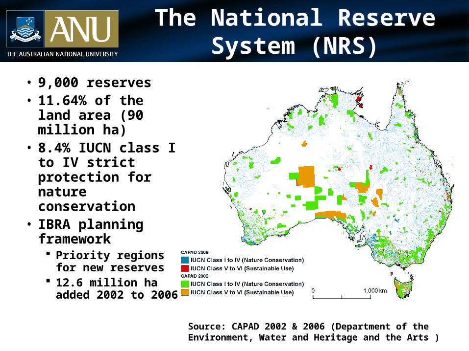
The National Reserve System (NRS)
• 9,000 reserves • 11.64% of the land
area (90 million ha) • 8.4% IUCN class I to
IV strict protection for nature conservation
• IBRA planning framework Priority regions for
new reserves 12.6 million ha added
2002 to 2006
Source: CAPAD 2002 & 2006 (Department of the Environment, Water and Heritage and the Arts )
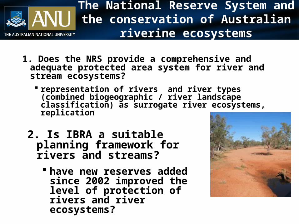
The National Reserve System and the conservation of Australian riverine ecosystems
1. Does the NRS provide a comprehensive and adequate protected area system for river and stream ecosystems? representation of rivers and river types (combined
biogeographic / river landscape classification) as surrogate river ecosystems, replication
2. Is IBRA a suitable planning framework for rivers and streams? have new reserves added since 2002
improved the level of protection of rivers and river ecosystems?

Protected streams and basins
Entire river systems rarely protected
4 basins with area >500km2 protected from source to outlet
Proportion of drainage basin in an IUCN class I to IV protected area
Davey RiverOld River
Marangarrayu (West Alligator) River
Mason Gully
Topographically defined drainage basins
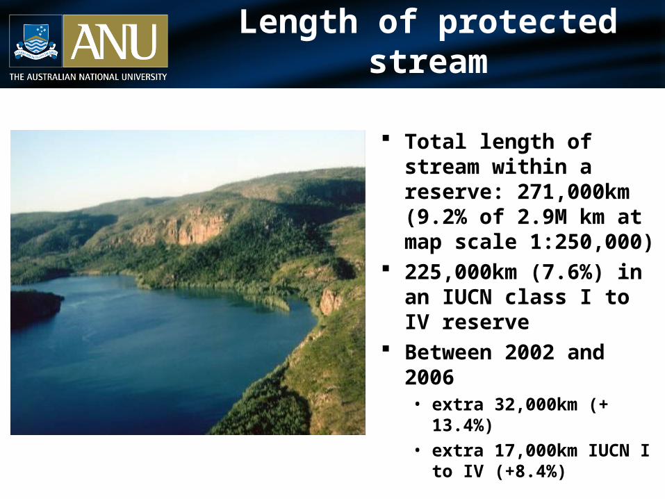
Length of protected stream
Total length of stream within a reserve: 271,000km (9.2% of 2.9M km at map scale 1:250,000)
225,000km (7.6%) in an IUCN class I to IV reserve
Between 2002 and 2006 • extra 32,000km (+ 13.4%)• extra 17,000km IUCN I to IV
(+8.4%)
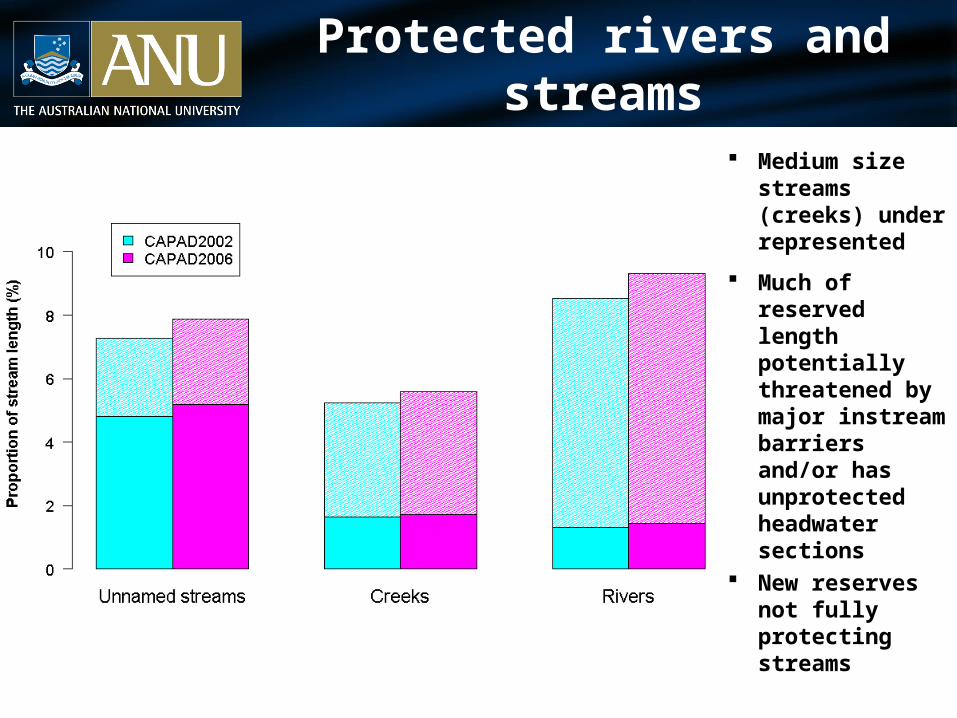
Protected rivers and streams
Medium size streams (creeks) under represented
Much of reserved length potentially threatened by major instream barriers and/or has unprotected headwater sections
New reserves not fully protecting streams
Comprehensively protecting riverine ecosystems?
No national inventory of river ecosystems• biogeographic / river landscape classification maps surrogate ecosystems
Biogeographic classification: TNC/WWF Freshwater Ecoregions of the World
• reflect the effects of historical processes that limit the pool of species within a river
River Landscape classification: River Environment Types (Stein,2007)
• describe associations of environmental factors (climate, topography, geology etc.) that drive the pattern of flow, channel morphology, substratum, temperature and mineral nutrients that collectively define the physical habitat template of stream ecosystems
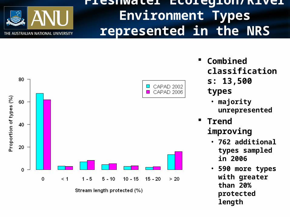
Freshwater Ecoregion/River Environment Types represented in the NRS
(IUCN I to IV protected area)
Combined classifications: 13,500 types• majority
unrepresented
Trend improving• 762 additional
types sampled in 2006
• 590 more types with greater than 20% protected length
Freshwater Ecoregion/River Environment Types represented in the NRS
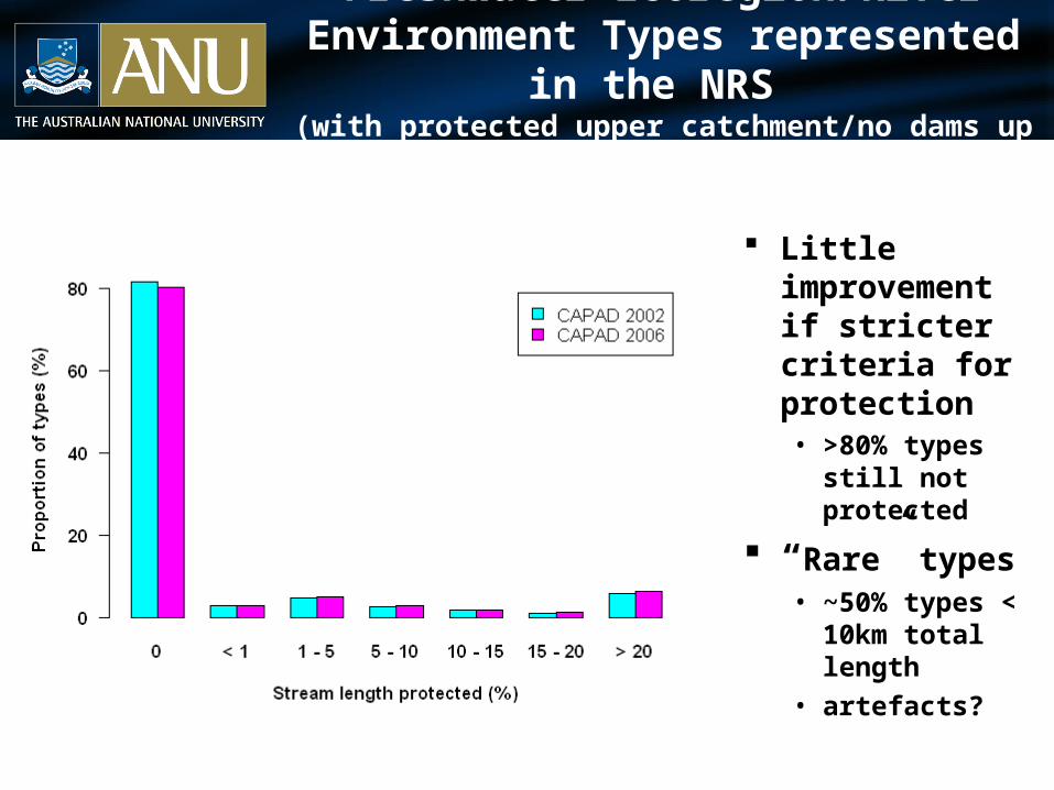
(with protected upper catchment/no dams up or downstream)
Little improvement if stricter criteria for protection• >80% types still
not protected
“Rare” types• ~50% types <
10km total length
• artefacts?
Freshwater Ecoregion/River Environment Types represented in the NRS
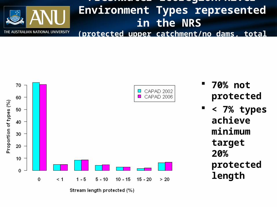
(protected upper catchment/no dams, total length > 10km)
70% not protected
< 7% types achieve minimum target 20% protected length
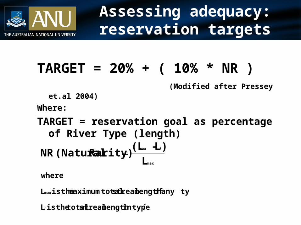
Assessing adequacy: reservation targets
TARGET = 20% + ( 10% * NR ) (Modified after Pressey et.al 2004)
Where:
TARGET = reservation goal as percentage of River Type (length)
ii
i
typein length stream total theis L
typeany of length stream totalmaximum theis L
where
max
max
max
L)L – (L
Rarity) (NaturalNR
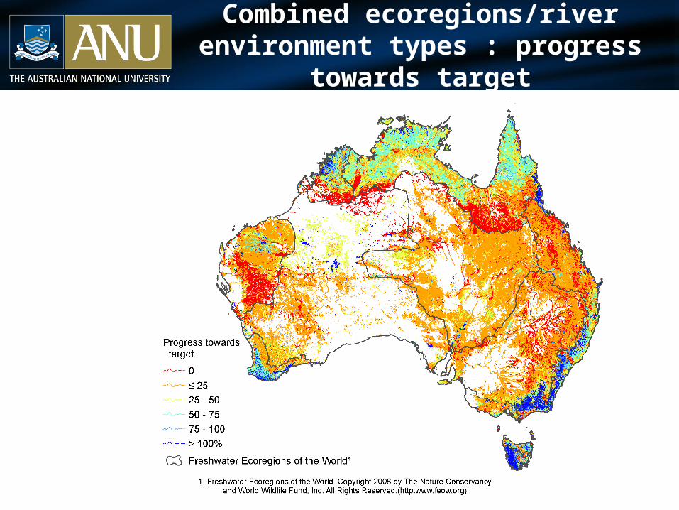
Combined ecoregions/river environment types : progress towards target
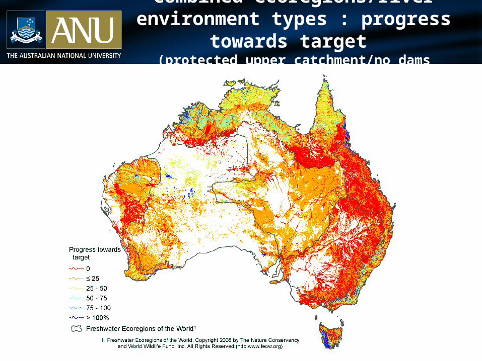
Combined ecoregions/river environment types : progress towards target
(protected upper catchment/no dams downstream)
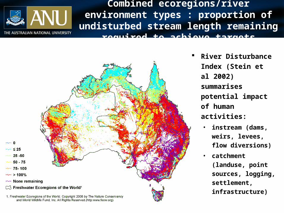
Combined ecoregions/river environment types : proportion of undisturbed stream length remaining
required to achieve targets
River Disturbance
Index (Stein et al 2002)
summarises potential
impact of human
activities:
• instream (dams,
weirs, levees, flow
diversions)
• catchment (landuse,
point sources,
logging, settlement,
infrastructure)
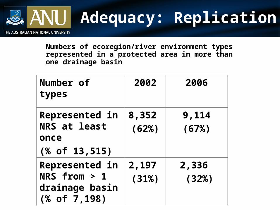
Adequacy: Replication
Numbers of ecoregion/river environment types represented in a protected area in more than one drainage basin
Number of types 2002 2006
Represented in NRS at least once
(% of 13,515)
8,352
(62%)
9,114
(67%)
Represented in NRS from > 1 drainage basin (% of 7,198)
2,197
(31%)
2,336
(32%)
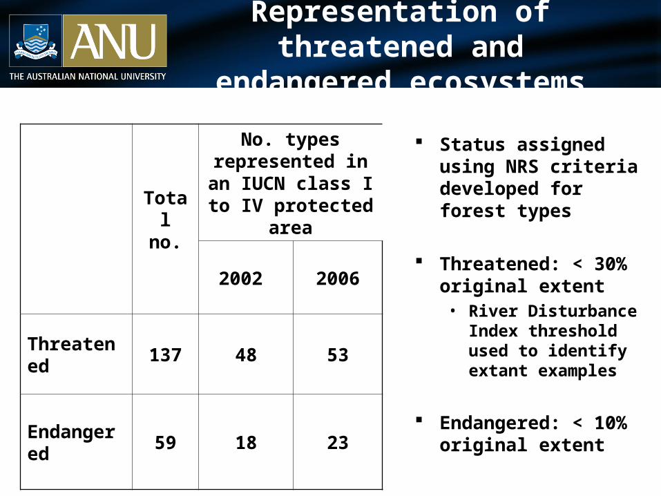
Representation of threatened and endangered ecosystems
Total no.
No. types represented in an IUCN class I to IV
protected area
2002 2006
Threatened 137 48 53
Endangered 59 18 23
Status assigned using NRS criteria developed for forest types
Threatened: < 30% original extent• River Disturbance Index
threshold used to identify extant examples
Endangered: < 10% original extent
Limitations and uncertainties
Preliminary results-opportunities for improvements• River Environment Types
characterization of landscape processes data quality and consistency
• Biogeographic classifications for different functional groups
• Nested assessments: continental->regional -> catchment Incorporate biological data Spatial surrogates for critical processes (hydrological,
geomorphological, ecological and evolutionary)
• Measuring adequacy
Moving beyond simple percentage targets and the degree of replication
Conclusions
• The NRS does not provide a comprehensive and adequate protected area system for Australian rivers and streams for some river ecosystem types few remaining options
• Protecting entire catchments will be difficult a range of complimentary “off-reserve” protection measures
needed
• IBRA planning framework has not produced a substantial improvement in the comprehensiveness or adequacy of the NRS for rivers and streams (despite a large investment in new reserves) Not recognizing threatening processes occurring outside of
protected areas
% land area protected not a good indicator for river ecosystem protection
Thank you