Embed Size (px)
Citation preview
THE ALTONA FLAT ROCK JACK PINE BARRENS: A LEGACY OF FIRE AND ICE
David A. Franzi and Kenneth B. Adams Center for Earth and Environmental Science
State University of New York Plattsburgh, New York 12901
Inthxluction
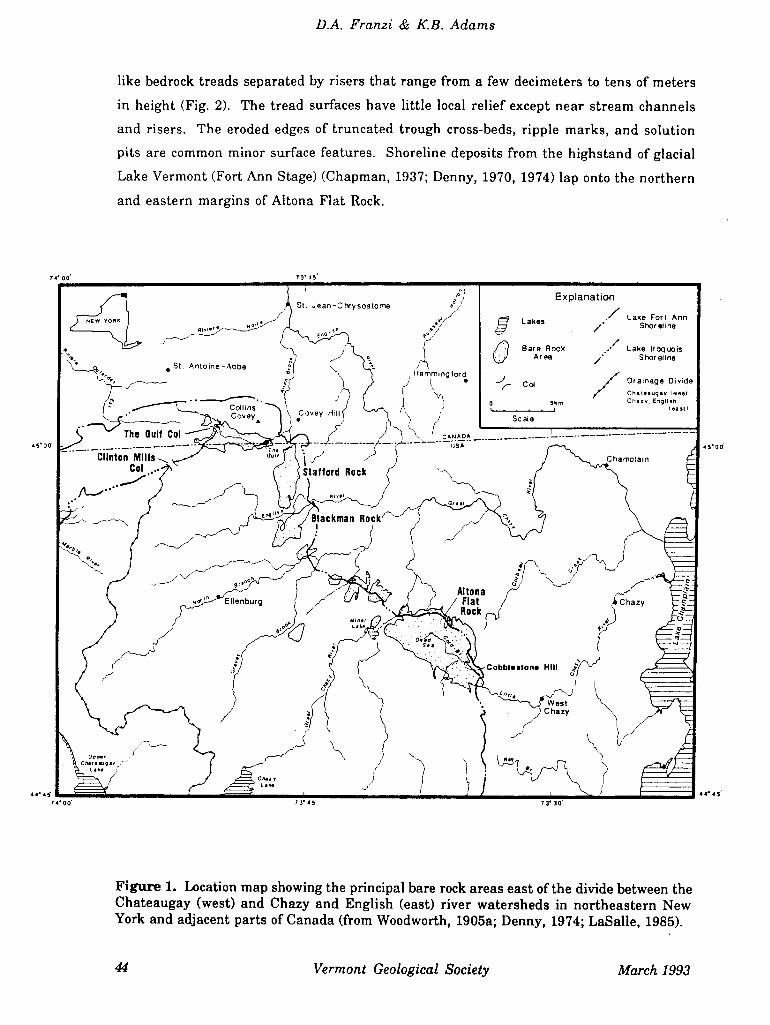
Altona Flat Rock is the largest (approximately 32 km 2) of a discontinuous, 5-kilometer
wide belt of bare sandstone areas that extend approximately 30 km southeastward into the
Champlain Valley from Covey Hill, near Hemmingford, Québec (Fig. 1). Created by
catastrophic floods from the drainage of glacial Lake Iroquois and younger post-Iroquois
proglacial lakes in the St. Lawrence Lowland more than 12,000 years ago (Denny, 1974;
Clark and Karrow, 1984; Pair et al., 1988), the exposed sandstone today provides habitat for
one of the largest jack pine (Pinus banksiana) barrens in the eastern United States. The
relatively low-diversity jack pine community is maintained by fire, which has an
important role in ecosystem regeneration in this nutrient-poor, drought-prone
environment.
We will visit several sites in the southeastern portion of Altona Flat Rock on property
owned by the William H. Miner Agricultural Research Institute. The area contains the
remains of the "Million-Dollar Dam," part of a failed hydroelectric project begun by
William Miner in 1910. This trip will address on-going efforts to understand the
linkages between the hydrogeology and ecology of the jack pine barrens and will document
the recent history of anthropogenic development in this unique ecosystem.
Geological Setting
Physiography
Altona Flat Rock, located in the northwestern Champlain Valley (Fig. 1), is entirely
underlain by flat-lying Potsdam Sandstone (Cambrian). The lithology of the Potsdam
ranges from orange-pink to pale red, very coarse to medium-grained, cross-laminated
arkose with quartzitic green shale and conglomeratic interbeds to pinkish gray to very
pale orange, well sorted, fine to medium-grained quartz sandstone (Fisher, 1968). The
exposed rock surface slopes north and east from an elevation of more than 300 meters a.s.l.
(above sea level) to below 200 meters a.s.l. where it passes beneath surficial deposits in the
Champlain Lowland (Denny, 1974). The sloping surface is broken into a series of stair-
Volume 7 Vermont Geology 43
D.A. Franzi & KB. Adams
like bedrock treads separated by risers that range from a few decimeters to tens of meters
in height (Fig. 2). The tread surfaces have little local relief except near stream channels
and risers. The eroded edges of truncated trough cross-beds, ripple marks, and solution
pits are common minor surface features. Shoreline deposits from the highstand of glacial
Lake Vermont (Fort Ann Stage) (Chapman, 1937; Denny, 1970, 1974) lap onto the northern
and eastern margins of Altona Flat Rock.
7400' 73•45_
4500
• St. Antoine-Abbe
Collins
The Gulf Col
— Clinton Mills -. Col •..
.—.
St. Jean-Ctysostome -/ Explanation
Lakes ./' Lake Fort Ann
/ Shoreline
Bare Rock .' Lake Iroquois
/ Shoreline
Hemming tord
Co'
es Drainage Divide
/
Chiiitvgiv twestj
Covey Hill /
5flh Chiry, Eniiit,
•
/
Sce
_.__/___ USA
aflo:dRockf
4 s• o
N
Aitona j- Flat Rock
Cabbl.aton. Hill
West hazy
C hazy
44• 4S
Ott., C,.,. eg.y
Chit
7 3• 45 7 3•
4. 45
Figure 1. Location map showing the principal bare rock areas east of the divide between the Chateaugay (west) and Chazy and English (east) river watersheds in northeastern New York and adjacent parts of Canada (from Woodworth, 1905a; Denny, 1974; LaSalle, 1985).
44 Vermont Geological Society March 1993
Altona Flat Rock Jack Pine Barrens
300
MON C,)
260 ci)
(220 cu >
- 200 U]
lillion-Dollar Dam
Skeleton Dam
Upland Profile
Dead Sea
Brook Profile
[:111
160 '- 0.0
1.0 2.0 3.0 4.0 5.0 6.0
Distance Upstream from gauge at the Million-Dollar Dam (km)
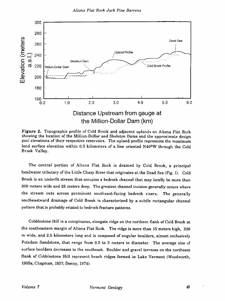
Figure 2. Topographic profile of Cold Brook and adjacent uplands on Altona Flat Rock showing the location of the Million-Dollar and Skeleton Dams and the approximate design pool elevations of their respective reservoirs. The upland profile represents the maximum land surface elevation within 0.5 kilometers of a line oriented N40°W through the Cold Brook Valley.
The central portion of Altona Flat Rock is drained by Cold Brook, a principal
headwater tributary of the Little Chazy River that originates at the Dead Sea (Fig. 1). Cold
Brook is an underfit stream that occupies a bedrock channel that may locally be more than
200 meters wide and 25 meters deep. The greatest channel incision generally occurs where
the stream cuts across prominent southeast-facing bedrock risers. The generally
southeastward drainage of Cold Brook is characterized by a subtle rectangular channel
pattern that is probably related to bedrock fracture patterns.
Cobblestone Hill is a conspicuous, elongate ridge on the northern flank of Cold Brook at
the southeastern margin of Altona Flat Rock. The ridge is more than 15 meters high, 500
m wide, and 2.5 kilometers long and is composed of angular boulders, almost exclusively
Potsdam Sandstone, that range from 0.5 to 3 meters in diameter. The average size of
surface boulders decreases to the southeast. Boulder and gravel terraces on the northeast
flank of Cobblestone Hill represent beach ridges formed in Lake Vermont (Woodworth,
1905a; Chapman, 1937; Denny, 1974).
Volume 7 Vermont Geology
D.A. Franzi & KB. Adams
Geological History
The exposure of large areas of sandstone in the northwestern Champlain Lowland
occurred more than 12,000 years before present by the erosional effects of ice-marginal
streams during the catastrophic drainage of glacial Lake Iroquois and younger post-
Iroquois lakes (Woodworth, 1905a, 1905b; Coleman, 1937; Denny, 1974; Clark and Karrow,
1984; Pair et al., 1988). Lake Iroquois occupied the Ontario Lowland and drained eastward
across an outlet threshold near Rome in the western Mohawk Lowland (Coleman, 1937).
The lake expanded northeastward into the St. Lawrence Lowland during deglaciation
between the Adirondack Uplands to the south and the waning Laurentide Ice Sheet margin
to the north. The former water level probably stood at a present elevation between 329 and
332 meters a.s.l. near Covey Hill, Québec (Fig. 1) (Denny, 1974; Clark and Karrow, 1984;
Pair et al., 1988).
Eastward drainage of Lake Iroquois began as lower outlets were exhumed along the
drainage divide between the Champlain and St. Lawrence drainage systems southwest of
Covey Hill during ice recession. The initial drainage may have occurred through a
channel approximately 1 km north of Clinton Mills (Fig. 1) that was controlled by a
threshold between 329 and 332 meters a.s.l. (Clark and Karrow, 1984). The falling levels
of proglacial lakes in the St. Lawrence and Ontario lowlands temporarily stabilized at the
glacial Lake Frontenac level (308-311meters a.s.I.) as the ice margin receded northward
and the col at The Gulf was uncovered (Clark and Karrow, 1984; Pair et al., 1988). Outflow
from these lakes was directed southeastward along the ice margin where it crossed the
English, North Branch and Great Chazy watersheds before eventually emptying into Lake
Fort Ann which occupied the Champlain Lowland at an elevation between 225 and 228
meters a.s.l. (Denny, 1974). The outflow streams stripped large areas of their surficial
cover and cut deep bedrock channels and plunge pools into the Potsdam Sandstone (Fig. 1),
e.g. The Gulf (MacClintock and Terasme, 1960) and the Dead Sea (Woodworth, 1905a;
Denny, 1974). The most intense scour (e.g. Stafford Rock, Blackman Rock, and Altona
Flat Rock) generally occurred on major watershed divides. Cobblestone Hill (Fig. 1) is an
accumulation of bouldery debris washed from the exposed rock areas by glacial lake
outflow floods (Woodworth, 1905a; Denny, 1974).
The scour of the areas southeast of the St. Lawrence-Champlain divide continued as ice
recession caused the drainage of Lake Frontenac around the northern flank of Covey Hill.
Denny (1974) suggested that the ice margin may have oscillated in the area around Covey
Hill causing the lakes in the eastern St. Lawrence Lowland to refill and empty several
46 Vermont Geological Society March 1993
Altona Flat Rock Jack Pine Barrens
times. The lake-drainage episodes ended when the ice front receded from the northern
flank of Covey Hill for the last time and the proglacial lake in the St. Lawrence Lowland,
Lake Belleville, was lowered to the level of Lake Fort Ann in the Champlain Lowland
(Pair et al., 1988).
The Jack Pine Barrens
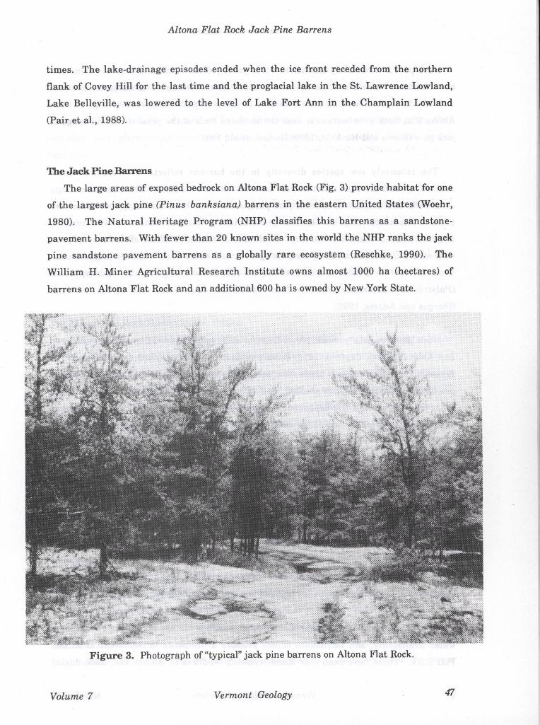
The large areas of exposed bedrock on Altona Flat Rock (Fig. 3) provide habitat for one
of the largest jack pine (Pinus banksiana) barrens in the eastern United States (Woehr,
1980). The Natural Heritage Program (NHP) classifies this barrens as a sandstone-
pavement barrens. With fewer than 20 known sites in the world the NHP ranks the jack
pine sandstone pavement barrens as a globally rare ecosystem (Reschke, 1990). The
William H. Miner Agricultural Research Institute owns almost 1000 ha (hectares) of
barrens on Altona Flat Rock and an additional 600 ha is owned by New York State.
Volume 7
Vermont Geology 47
D.A. Franzi & KB. Adams
Jack pine is a relatively short-lived (<150 years), shade-intolerant, boreal species that
has maintained a relic community at Altona Flat Rock because of its adaptations to fire
and ability to survive in an area with thin (or absent), nutrient-poor soils (Fig. 3). The
Altona Flat Rock pine barrens is near the southern limit of the present natural range of
jack pine (Burns and Honkala, 1990; Harlow, et al., 1991).
The relatively low species diversity in the barrens reflects low seasonal water
availability and the thin, nutrient-poor soils on Altona Flat Rock. The barrens consists
essentially of a single tree species, jack pine, with virtually no subcanopy or understory
trees. The understory shrubs are predominantly lowbush blueberry (Vaccinium
angustifolium), black huckleberry (Gaylussacia baccata), black chokeberry (Pyrus
melanocarpa), sweetfern (Comptonia peregrina), and sheep laurel (Kalmia angustifolia).
Ground cover is primarily reindeer lichen (Cladonia rangiferina), haircap moss
(Polytrichum commune), bracken fern (Pteridium aquilinum), and Sphagnum spp.
(Stergas and Adams, 1989).
Jack pine requires periodic crown fires for successful regeneration to occur (Ahlgren
and Ahlgren, 1960; Cayford, 1971; Rowe and Scotter, 1973; Cayford and McRae, 1983;
Rouse, 1986). Fire releases seeds from serotinous cones stored in the jack pine canopy,
prepares a nutrient-rich ash seedbed, and reduces competition for the young seedlings.
Since this barrens is a fire-dependent ecosystem, fire exclusion will ultimately cause the
local extinction of jack pine and the deterioration of the major heath plants, blueberry and
huckleberry.
The pine barrens community is well adapted for the Altona Flat Rock environment.
Mean annual precipitation from meteorological records for a 27-year period between July,
1963 to August, 1992 at the Miner Institute in Chazy, New York is approximately 80 cm.
Mean monthly air temperature ranges from -11 0C in January to 200 C in July (Stergas and
Adams, 1989). Summer air temperature in bare rock areas, however, may be as much as
160C higher than in the surrounding areas, and midday temperatures commonly exceed
38 0C (Woehr, 1980). Preliminary data from observation wells on Altona Flat Rock
indicate that, in many places, the water table lies well below the depth of root penetration.
The combined effects of anomalously high summer air temperature, low seasonal
water availability, and flammable foliage produce a fire-prone environment at Altona
Flat Rock. There have been four stand-replacing wildfires at Altona Flat Rock during
48 Vermont Geological Society March 1993
Altona Flat Rock Jack Pine Barrens
this century (1919, 1940, 1957 and 1965). The oldest jack pine stand at Altona Flat Rock (ca.
73 years) is beginning to show signs of decline. Nearly 40 percent of the trees in this stand
(1919 burn area) are dead (Hawver, 1992). The accumulation of dead tree biomass
increases the probability of another fire in this stand. A fire management plan, that
includes both planned-ignition and natural-ignition fires, is needed for the entire
barrens.
The exclusion of fire from a fire-dependent ecosystem such as the jack pine barrens
can result in a loss of biodiversity. At the landscape level, the complex mosaic of habitat
types created and maintained by fire can benefit many species of plants and animals. The
use of prescribed fire to preserve biodiversity in the barrens, however, will require several
more years of ecological research and careful planning and coordination with local fire-
control agencies and the New York Department of Environmental Conservation.
The Altona Flat Rock Hydroelectric Pmject
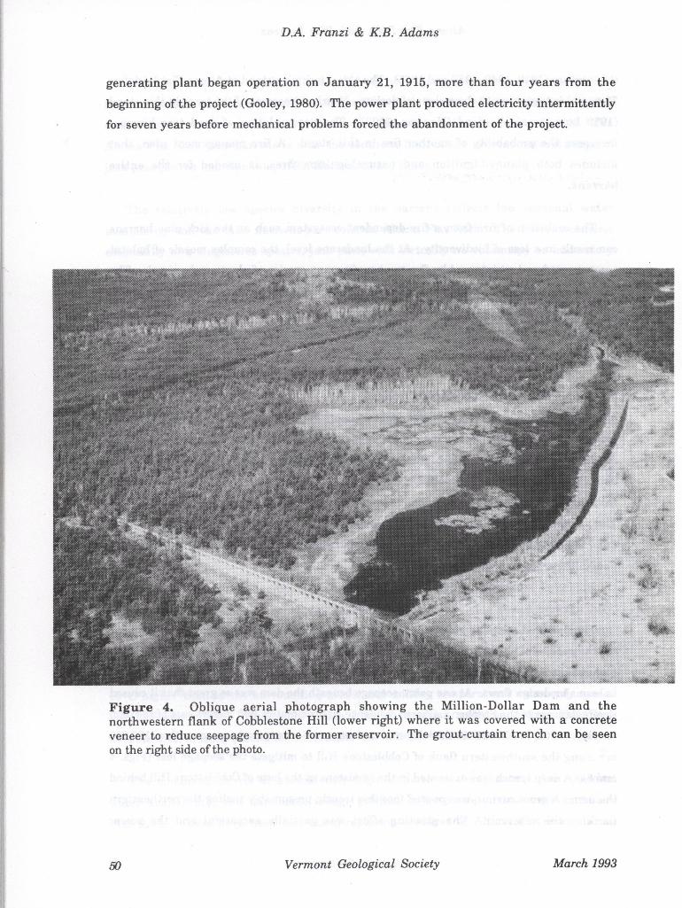
In the summer of 1910, William Miner, ignoring the advice of his engineers, began
construction of a hydroelectric dam and generating station on the southeastern margin of
Altona Flat Rock (Gooley, 1980). By the time of its completion in March, 1913, the concrete
dam, known locally as the "Million-Dollar Dam," had a maximum height of over 10
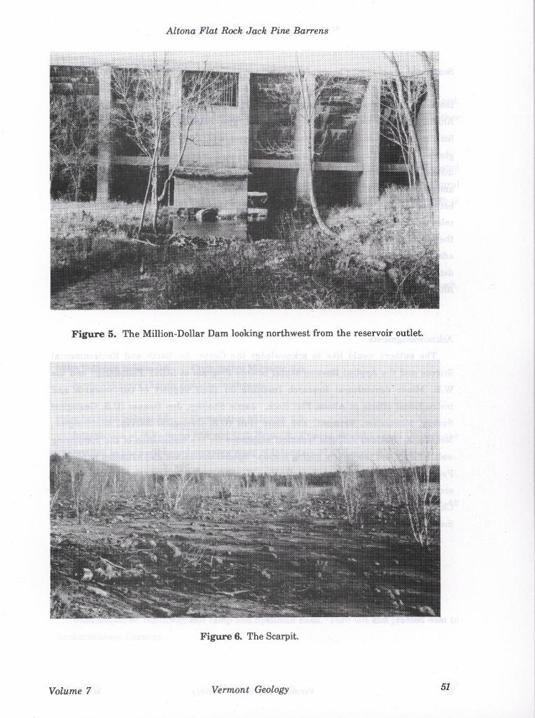
meters and stretched more than 700 meters across the Cold Brook valley (Figs. 4 and 5).
The design capacity of the reservoir was more than 3.5 million cubic meters. A second
dam, the Skeleton Dam (Gooley, 1980), was constructed upstream to provide supplemental
flow to the main impoundment (Fig. 2).
The dam and generating station were completed in 1913 but it took almost two years to
fill the reservoir to near capacity. The inadequate now of Cold Brook and ground water
seepage through Cobblestone Hill, which formed the eastern flank of the reservoir, proved
to be major design flaws. At one point, seepage beneath the dam was so great that it caused
severe damage to the Stephen LaPierre residence, approximately 600 meters east of the dam
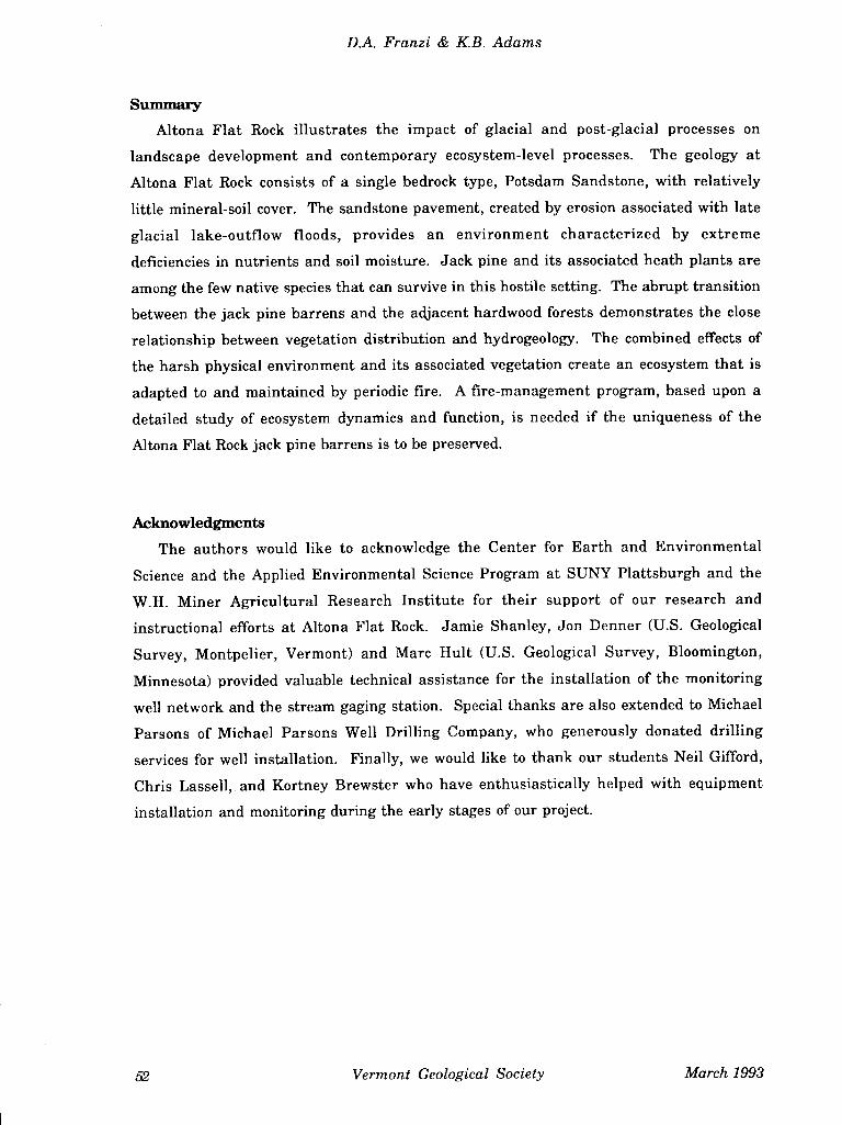
(Gooley, 1980). A 10 to 15 cm thick layer of concrete grout was spread over more than 100,000
111 2 along the southwestern flank of Cobblestone Hill to mitigate the seepage loss (Figs. 4
and 6). A deep trench was excavated in the sandstone at the base of Cobblestone Hill behind
the dam. A grout curtain was poured into this trench, presumably sealing the northeastern
flank of the reservoir. The grouting effort was partially successful and the power
Volume 7 Vermont Geology 49
D.A. Franzi & KB. Adams
generating plant began operation on January 21, 1915, more than four years from the
beginning of the project (Gooley, 1980). The power plant produced electricity intermittently
for seven years before mechanical problems forced the abandonment of the project.
Vermont Geological Society March 1993
Altona Flat Rock Jack Pine Barrens
Figure 5. The Million-Dollar Dam looking northwest from the reservoir outlet.
Figure 6. The Scarpit.
Volume 7 Vermont Geology 51
D.A. Franzi & KB. Adams
Stimmziry
Altona Flat Rock illustrates the impact of glacial and post-glacial processes on
landscape development and contemporary ecosystem-level processes. The geology at
Altona Flat Rock consists of a single bedrock type, Potsdam Sandstone, with relatively
little mineral-soil cover. The sandstone pavement, created by erosion associated with late
glacial lake-outflow floods, provides an environment characterized by extreme
deficiencies in nutrients and soil moisture. Jack pine and its associated heath plants are
among the few native species that can survive in this hostile setting. The abrupt transition
between the jack pine barrens and the adjacent hardwood forests demonstrates the close
relationship between vegetation distribution and hydrogeology. The combined effects of
the harsh physical environment and its associated vegetation create an ecosystem that is
adapted to and maintained by periodic fire. A fire-management program, based upon a
detailed study of ecosystem dynamics and function, is needed if the uniqueness of the
Altona Flat Rock jack pine barrens is to be preserved.
Acknowledgments
The authors would like to acknowledge the Center for Earth and Environmental
Science and the Applied Environmental Science Program at SUNY Plattsburgh and the
W.H. Miner Agricultural Research Institute for their support of our research and
instructional efforts at Altona Flat Rock. Jamie Shanley, Jon Denner (U.S. Geological
Survey, Montpelier, Vermont) and Marc Hult (U.S. Geological Survey, Bloomington,
Minnesota) provided valuable technical assistance for the installation of the monitoring
well network and the stream gaging station. Special thanks are also extended to Michael
Parsons of Michael Parsons Well Drilling Company, who generously donated drilling
services for well installation. Finally, we would like to thank our students Neil Gifford,
Chris Lassell, and Kortney Brewster who have enthusiastically helped with equipment
installation and monitoring during the early stages of our project.
52 Vermont Geological Society March 1993
Altona Flat Rock Jack Pine Barrens
I DIM DIN V ti uJ a) DR191 ;i I W I(O]J
The road log begins at the Lake Champlain Ferry dock on Cumberland Head,
Plattsburgh, New York. Road log distances are presented in English units. All other
measurement are in SI units.
Persons using this log in the future should be aware that the field trip stops are located
on private property that is owned and patrolled by the William H. Miner Agricultural
Research Institute. A permit must be obtained from the Miner Institute (518-846-8020) to
access this property.
START
Miles between points: 0.0 Cumulative Mileage: 0.0
Assemble in the Lake Champlain Ferry parking lot at Cumberland Head, Plattsburgh,
New York.
Proceed west on N.Y. Route 314 toward Plattsburgh.
Miles between points: 0.8 Cumulative Mileage: 0.8
Route 314 bears sharply right (to northwest).
Miles between points: 32 Cumulative Mileage: 4.0
Intersection of N.Y. Route 314 and U.S. Route 9. Proceed straight ahead through the
intersection to the northbound entrance ramp of Interstate 87 (Adirondack Northway).
Miles between points: 0.1 Cumulative Mileage: 4.1
Northbound entrance ramp. Turn right (north) and proceed to Interchange 40
(Speliman Road) in Beekmantown.
Miles between points: 3.8 Cumulative Mileage: 7.9
Exit ramp at Interchange 40. Exit right and proceed to Speliman Road.
Miles between points: 0.1 Cumulative Mileage: 8.0
Intersection of Northway exit ramp and Speilman Road. Turn left and proceed west to
Beekmantown Corners.
Volume 7 Vermont Geology
D.A. Franzi & KB. Adams
Miles between points: 2.7 Cumulative Mileage: 10.7
Intersection of Speilman Road and U.S. Route 22. Turn right and proceed north on
U.S. Route 22.
Miles between points 3A Cumulative Mileage: 14.1
Intersection of U.S. Route 22, N.Y. Route 348, and West Church Street in West Chazy.
Turn left and proceed west on West Church Street.
Miles between points: 0.7 Cumulative Mileage: 14.8
Intersection of West Church Street, Parker Road, and ONeil Road. Bear left then right
to remain on West Church Street.
Miles between points: 0.8 Cumulative Mileage: 15.6
Intersection of West Church Street and Barnaby Road. Turn right and proceed north
on Barnaby Road.
Miles between points: 1.0 Cumulative Mileage: 16.6
Barnaby Road changes to a gravel surface at the farm just north of Slosson Road
intersection.
STOP 1: LAKE FORT ANN BEACH RIDGES
Miles between points: 1.0 Cumulative Mileage: 17.6
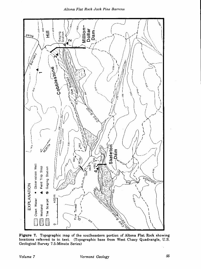
Park at the gate at the entrance of the Miner Institute property and continue northward
on foot along Barnaby Road approximately 100 meters (320 ft). Turn left into woods and
proceed west for 150 to 200 meters (500-750 ft) up the eastern flank of Cobblestone Hill (Fig.
7). The beach ridges occur at elevations between 175 and 205 meters (580 and 670 ft) above
sea level (Denny, 1974).
The beach ridges on Cobblestone Hill were first described by Woodworth (1905a) and
later by Denny (1974). The beaches consist predominantly of moderately rounded to well
rounded, pebble to cobble gravel that is deposited in multiple, elongate, low-relief ridges
that extend along the northern and eastern flanks of Cobblestone Hill between 175 and 205
meters a.s.l. (Fig. 7). Individual deposits are typically as much as 1 meter high and 30
meters wide, and often extend laterally for more than 400 meters (Denny, 1974). The
54 Vermont Geological Society March 1993
Altona Flat Rock Jack Pine Barrens
(I I Qr
/
4
r JI 0
'1 /
a 2 CL i
/ < i; o /
CI 1) \\\\\
\
Figure 7. Topographic map of the southeastern portion of Altona Flat Rock showing locations referred to in text. (Topographic base from West Chazy Quadrangle, U.S. Geological Survey 7.5-Minute Series)
Volume 7 Vermont Geology
D.A. Franzi & KB. Adams
gravel is almost exclusively composed of Potsdam Sandstone that was presumably derived
from the alluvial cobble to boulder gravel that composes Cobblestone Hill.
Return to the vehicles at the gate after the discussion at this stop.
Proceed through the entrance gate. Low roadside excavations approximately 75 meters
(250 ft) west of the gate expose the cobble gravel that comprises the Lake Fort Ann beach
ridges. Near the crest of the ridge the angular, 0.3 to 1.2 meter (1 to 4 ft) diameter boulders
that comprise the core of Cobblestone Hill can be observed at the surface. The remains of
the "Million-Dollar Dam" can be seen on the right just southwest of the hill crest.
STOP 2: THE "MILLION-DOLLAR DAM"
Miles between points: 0.3 Cumulative Mileage: 17.9
The "Million-Dollar Dam" and hydroelectric generation plant was completed on 11
March, 1913 and operated intermittently from 21 January, 1915 until its closure in 1922. A
large hole was blasted in the dam shortly after William Miner's death in 1930 to permit
Cold Brook to drain freely through the former reservoir. The Altona Flat Rock sandstone
pavement is exposed southwest of Cold Brook. The change from mixed deciduous,
primarily oak, forest on Cobblestone Hill to jack pine barrens on Altona Flat Rock is
characteristically sharp at this location.
A gaging station was constructed at the reservoir outlet in the fall of 1992 to
continuously monitor surface-water discharge (Fig. 7). The gaging station is part of a
joint initiative by the Center for Earth and Environmental Science and the Applied
Environmental Science Program at the SUNY Plattsburgh and the W.H. Miner
Agricultural Research Institute to establish an instrumented field station for
undergraduate research and instruction in geology and environmental science at the
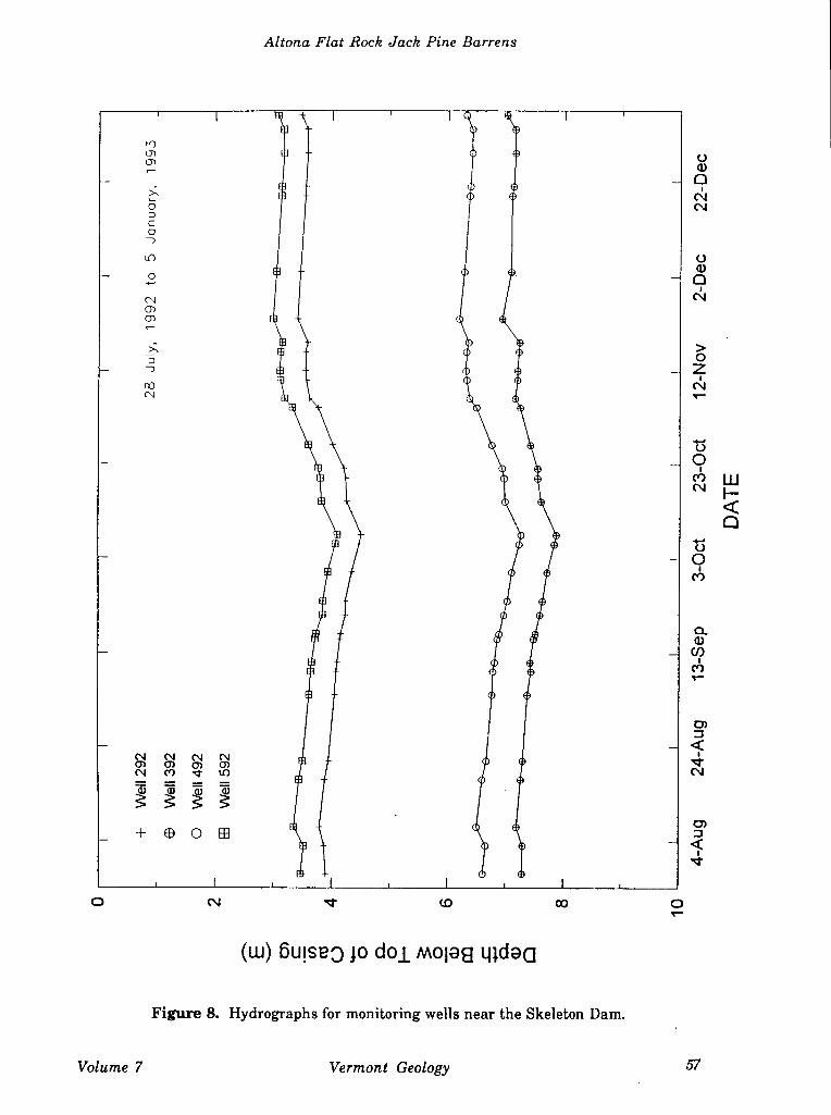
Miner Dam site. A monitoring-well network, consisting of nine wells ranging in depth
from 10 to 25 meters, was completed in May, 1992 between the northeastern portion of the
former Million-Dollar dam reservoir and the Skeleton Dam (Fig. 7). Water-level
measurements were begun in late July, 1992 (Fig. 8). Future plans include the installation
of a weather station, an inflow stream gaging station, and expansion of the monitoring-
well network. The field station will provide an important linkage between traditional and
applied educational opportunities that addresses some of the unique geological and
ecological aspects of the Altona Flat Rock region.
Vermont Geological Society March 1993
Altona Flat Rock Jack Pine Barrens
V) O) 0)
>'
0
C 0 -)
u)
0
CO
N 0) 0}
>'
(N
0 a) 0
c'J
0 ci) 0
> 0
c'J
0
CN
0
0
C,,
0 ci) (I)
C')
c,)
N N N N 0) 0)0)0) N C') - to
1HI D)
(14 (0 CO 0
(w) 6u!seO jo doj moleg qjd
Figure 8. Hydrographs for monitoring wells near the Skeleton Dam.
Volume 7 Vermont Geology 57
D.A. Franzi & KB. Adams
Return to the vechicles following the discussions at this stop and proceed eastward
toward Cobblestone Hill. Turn left onto a small road near the crest of the hill that leads
northwestward along the flank of the former reservoir (Fig. 7).
STOP 3: THE VFHE SCARP1T"
Miles between points: 02 Cumulative Mileage: 18.1
The "scarpit" is the local name given to the desolate landscape created by efforts to
grout the porous boulder gravel slope of Cobblestone Hill (Figs. 6 and 7). The surface
consists of a thin (1.2 to 2.5 cm) layer of cement that was poured and raked between large
boulders composed predominantly of Potsdam Sandstone. The trench that was dug for the
grout curtain (Fig. 4) can be observed approximately 100 meters west of the concrete road
that parallels the former shoreline of the reservoir.
Return to the vehicles following the discussions at this stop and proceed northwestward
on the concrete road.
Miles between points: 0.5 Cumulative Mileage: 18.8
The first of nine observation wells drilled in May 1992 can be observed to the left near
the treeline at the edge of the grout surface. The wooded area beyond the well is part of
minor southeast-facing bedrock riser. The slope of Cobblestone Hill steepens and the
boulder size increases to the northwest.
Miles between points: 0.5 Cumulative Mileage: 19.1
The concrete road ends and the access road bears sharply northeast and continues on
the bedrock surface through the jack pine barrens.
Miles between points: 0.1 Cumulative Mileage: 19.2
The road crosses a surface-water supported wetland. The road bed is deeply rutted
where it crosses a wetland that contains 0.2 to 1.0 meters of organic soil. Observation wells
located approximately 50 meters northeast and 70 meters southwest of the wetland indicate
that the water table is more than 7.5 meters below the surface.
58 Vermont Geological Society March 1993
Altona Flat Rock Jack Pine Barrens
Miles between points: 02 Cumulative Mileage: 19.4
The road crosses a small channel that contains a large wetland. A concrete wall on the
left (south) side of the road was constructed to prevent water impounded behind the
"Million-Dollar Dam" to escape northward through this channel (Fig. 7).
The access road forks immediately west of the channel. The right fork leads to an
abandoned fire tower on the top of Pine Ridge. Bear left and proceed southward.
STOP 4: THE "SKELETON DAM" & CHASM LAKE
Miles between points: 02 Cumulative Mileage: 19.6
The partially completed "Skeleton Dam" was designed to augment flow to the reservoir
impounded behind the "Million-Dollar Dam" (Figs. 7 and 8). The dam impounds "Chasm
Lake" (Gooley, 1980), presumably named for the deep gorge cut into a prominent sandstone
riser at its northwestern edge.
The water level of Chasm Lake dropped more than 2 meters below the spillway of the
Skeleton Dam during the summers of 1991 and 1992. What little surface flow reached the
basin during the summer months was lost by evaporation and ground-water seepage from
the basin. Water level measurements from nearby observation wells since late July, 1992
indicate that steep, eastwardly directed hydraulic gradients exist at the southeastern flank
of Chasm Lake, providing support for the hypothesis that some water is being lost from the
reservoir by groundwater seepage.
Return to vehicles after the discussion at this stop and follow the rod log in reverse
order to the Lake Champlain Ferry dock at Cumberland Head.
Miles between points: 19.6 Cumulative Mileage: 392
Lake Champlain Ferry dock.
End of road log.
Volume 7 Vermont Geology
D.A. Franzi & KB. Adams
References
Ahigren, I.F. and Ahigren, C.E., 1960, Ecological effects of forest fires; Botanical. Review, 26: 483-533.
Burns, R.M. and Honkala, B.H., 1990, Silvics of North America I. Conifers; U.S. Dept. Agriculture Forest Service, Agricultural Handbook No. 654, 675 p.
Cayford, J.H., 1971, The role of fire in the ecology and silviculture of jack pine; Proc. Tall Timbers Fire Ecology Conference 10: 221-224.
Cayford, J.H. and McRae, D.J., 1983, The ecological role of fire in jack pine forests; La Wein, R.W. and MacLean, D.A. (eds.), The Role of Fire Northern Circum polar Ecosystems, John Wiley and Sons, New York, pp.183-199.
Chapman, D.H., 1937, Late-glacial and postglacial history of the Champlain Valley; Amer. Journal of Science, v. 34, 5th Ser., No.200, pp. 89-124.
Clark, P.U. and Karrow, P.F., 1984, Late Pleistocene water bodies in the St. Lawrence Lowland, New York, and regional correlations; Geol. Soc. of Amer. Bulletin 95: 805-813.
Coleman, A.P., 1937, Lake Iroquois; Ontario Dept. Mines 45th Ann. Report, 1936, v. 45, Part 7, p. 1-36.
Denny, C.S., 1970, Surficial geologic map of the Mooers quadrangle and part of the Rouses Point quadrangle, Clinton County, New York; United States Geological Survey Misc. Geol. Investigations Map 1-630.
Denny, C.S., 1974, Pleistocene geology of the northeastern Adirondack region, New York; United States Geological Survey, Professional Paper 786, 50 p.
Fisher, D.W., 1968, Geology of the Plattsburgh and Rouses Point, New York-Vermont quadrangles; New York State Museum and Science Service, Map and Chart Series No. 10, 51 p.
Gooley, L., 1980, A history of Altona Flat Rock, located in Clinton County, New York State; Denton Publications, Inc., Elizabethtown, New York, 103 p.
Harlow, W.M., Harrar, J.W., Hardin, E.S., and White, F.M., 1991, Textbook of Dendrology, 7th Edition; McGraw-Hill, Inc., New York, 501 p.
Hawver, C.A., 1992, Stand structure in a jack pine forest chronosequence; Unpublished manuscript, 50 p.
LaSalle, Pierre, 1985, Géologie des sediments meubles de la region de Lacolle-Saint-Chrysostome, Rapport Preliminaire; Québec Ministère de L'Energie et des Ressources, ET83-21, 13p.
MacClintock, P. and Terasme, J., 1960, Glacial history of Covey Hill; Journal of Geology 68: 232-241.
60 Vermont Geological Society March 1993
Altona Flat Rock Jack Pine Barrens
Pair, D., Karrow, P.F., and Clark, P.U., 1988, History of the Champlain Sea in the central St. Lawrence Lowland, New York, and its relationship to water levels in the Lake Ontario basin; in Gadd, N. .R. (ed.), The Late Quaternary development of the Champlain Sea basin; Geological Association of Canada, Special Paper 35, pp.107-123.
Reschke, C., 1990, Ecological communities of New York State, New York State Heritage Program, Latham, New York, 96 p.
Rouse, C., 1986, Fire effects in the northeastern forests: jack pine; United States Department of Agriculture Forest Service General Technical Report NC-106.
Rowe, J.S. and Scotter, G.W., 1973, Fire in the boreal forest; Quaternary Research 3: 444-464.
Stergas, R.L. and Adams, K.B., 1989, Jack pine barrens in northeastern New York: Postfire macronutrient concentrations, heat content, and understory biomass; Canadian Journal of Forest Research 19: 904-9 10.
Woehr, J.R., 1980, The Altona Flat Rock jack pine barrens: Management Planning for a unique ecosystem; ill Dawson, J.C. (ed.), Procedings of the Seventh Annual Lake Champlain Basin Environmental Conference, pp. 52-57.
Woodworth, J.B., 1905a, Pleistocene geology of the Mooers Quadrangle; New York State Museum Bulletin No. 83, 67 p.
Woodworth, J.B., 1905b, Ancient water levels of the Champlain and Hudson valleys; New York State Museum Bulletin No. 84, 265 p.
Volume 7 Vermont Geology 61