Embed Size (px)
Citation preview
TThhee AAnniimmaass RRiivveerr TTrraaiillss SSyysstteemm AA ccoonncceeppttuuaall ppllaann ffoorr aa ttrraaiillss ssyysstteemm aanndd ooppeenn ssppaaccee uussee iinn AAzztteecc,, NNeeww MMeexxiiccoo..
2010
Animas River Trails System
2010 Page 2
Introduction ................................................................................................ 3 Getting Connected ..................................................................................... 4 Existing Trails ............................................................................................ 6 Ruins Road Trail ............................................................................... 6 Martinez Trail .................................................................................... 7 Chaco-Main-Llano Walk .................................................................... 8 Historic Walking Tour ........................................................................ 9 Riverside Park Trail .......................................................................... 9
Riverside-Hartman Pedestrian Bridge ............................................. 10
Future Trails & Parks ............................................................................... 11 North Animas River Pedestrian Bridge ............................................ 11 North Main Avenue Walkway .......................................................... 12 Bridge Park ..................................................................................... 13 Eledge Ditch Trail ........................................................................... 14 Townsend Wildlife Nature Refuge & Trails ...................................... 15
Trail Information ........................................................................................ 17 Index of Trails .......................................................................................... 19 The Animas River Trails System is a collaborative project venture between:
Animas River Trails System
2010 Page 3
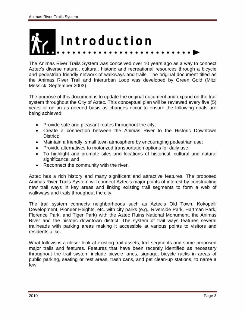
The Animas River Trails System was conceived over 10 years ago as a way to connect Aztec's diverse natural, cultural, historic and recreational resources through a bicycle and pedestrian friendly network of walkways and trails. The original document titled as the Animas River Trail and Interurban Loop was developed by Green Gold (Mitzi Messick, September 2003). The purpose of this document is to update the original document and expand on the trail system throughout the City of Aztec. This conceptual plan will be reviewed every five (5) years or on an as needed basis as changes occur to ensure the following goals are being achieved:
• Provide safe and pleasant routes throughout the city; • Create a connection between the Animas River to the Historic Downtown
District; • Maintain a friendly, small town atmosphere by encouraging pedestrian use; • Provide alternatives to motorized transportation options for daily use; • To highlight and promote sites and locations of historical, cultural and natural
significance; and • Reconnect the community with the river.
Aztec has a rich history and many significant and attractive features. The proposed Animas River Trails System will connect Aztec's major points of interest by constructing new trail ways in key areas and linking existing trail segments to form a web of walkways and trails throughout the city. The trail system connects neighborhoods such as Aztec’s Old Town, Kokopelli Development, Pioneer Heights, etc. with city parks (e.g., Riverside Park, Hartman Park, Florence Park, and Tiger Park) with the Aztec Ruins National Monument, the Animas River and the historic downtown district. The system of trail ways features several trailheads with parking areas making it accessible at various points to visitors and residents alike. What follows is a closer look at existing trail assets, trail segments and some proposed major trails and features. Features that have been recently identified as necessary throughout the trail system include bicycle lanes, signage, bicycle racks in areas of public parking, seating or rest areas, trash cans, and pet clean-up stations, to name a few.
Animas River Trails System
2010 Page 4
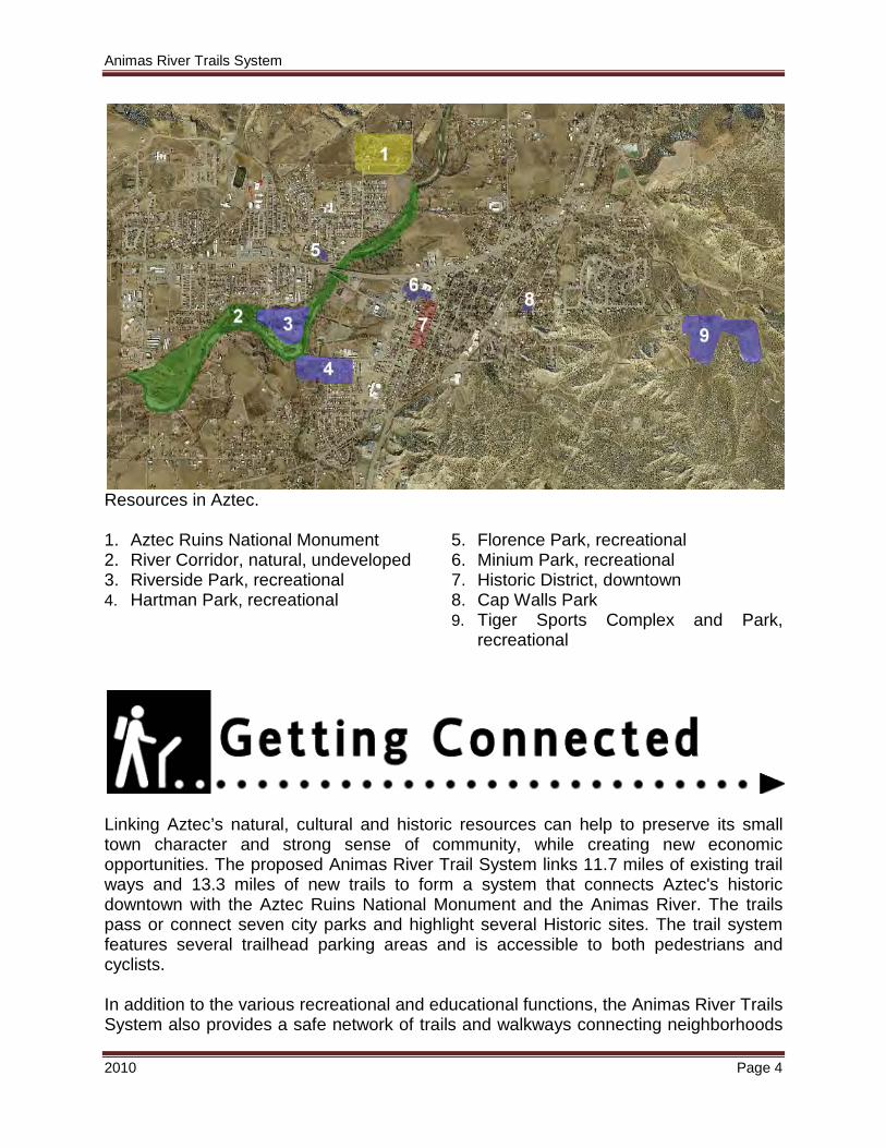
Resources in Aztec. 1. Aztec Ruins National Monument 2. River Corridor, natural, undeveloped 3. Riverside Park, recreational 4. Hartman Park, recreational
5. Florence Park, recreational 6. Minium Park, recreational 7. Historic District, downtown 8. Cap Walls Park 9. Tiger Sports Complex and Park,
recreational
Linking Aztec’s natural, cultural and historic resources can help to preserve its small town character and strong sense of community, while creating new economic opportunities. The proposed Animas River Trail System links 11.7 miles of existing trail ways and 13.3 miles of new trails to form a system that connects Aztec's historic downtown with the Aztec Ruins National Monument and the Animas River. The trails pass or connect seven city parks and highlight several Historic sites. The trail system features several trailhead parking areas and is accessible to both pedestrians and cyclists. In addition to the various recreational and educational functions, the Animas River Trails System also provides a safe network of trails and walkways connecting neighborhoods
Animas River Trails System
2010 Page 5
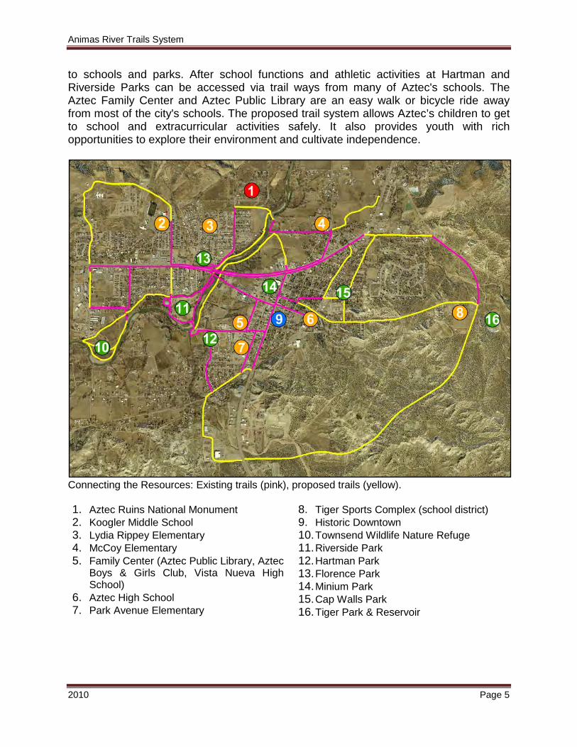
to schools and parks. After school functions and athletic activities at Hartman and Riverside Parks can be accessed via trail ways from many of Aztec's schools. The Aztec Family Center and Aztec Public Library are an easy walk or bicycle ride away from most of the city's schools. The proposed trail system allows Aztec’s children to get to school and extracurricular activities safely. It also provides youth with rich opportunities to explore their environment and cultivate independence.
Connecting the Resources: Existing trails (pink), proposed trails (yellow). 1. Aztec Ruins National Monument 2. Koogler Middle School 3. Lydia Rippey Elementary 4. McCoy Elementary 5. Family Center (Aztec Public Library, Aztec
Boys & Girls Club, Vista Nueva High School)
6. Aztec High School 7. Park Avenue Elementary
8. Tiger Sports Complex (school district) 9. Historic Downtown 10. Townsend Wildlife Nature Refuge 11. Riverside Park 12. Hartman Park 13. Florence Park 14. Minium Park 15. Cap Walls Park 16. Tiger Park & Reservoir

Animas River Trails System
2010 Page 6
Currently within the Animas River Trails System are 11.7 miles (61,959 ft) of existing trails varying from simple earthen trails to concrete sidewalks.
CONSTRUCTION FEET
ASPHALT 3,143
BRIDGE 738
CHIPPED WOOD 2,100
EARTHEN 5,652
GRAVEL 126
PAVED 299
SIDEWALKS 49,901
GRAND TOTAL 61,959
Ruins Road Trail The Ruins Road Trail segment incorporates 0.58 miles of new sidewalk to connect the intersection of Chaco Street, Ruins Road and Aztec Boulevard (NM 516) with Aztec Ruins National Monument (#1). This part of the trail also parallels a bicycle route and is ADA accessible. A new Aztec Ruins sign is proposed for the intersection of Ruins Road and Aztec Blvd (Hwy 516) to enhance its appearance and facilitate way finding. This trail passes through a tranquil neighborhood as it skirts Florence Park (#2), and the southern edge of the Aztec Ruins where it enters a wooded area, and will cross the Animas River via the proposed North Animas River Pedestrian Bridge (#3). It’s connectivity with Florence Park and the Aztec Ruins National Monument offers two locations for trailhead parking.
Animas River Trails System
2010 Page 7
What Is Needed • Completion of the trail system from Aztec Ruins National Monument to the North
Animas River Pedestrian Bridge. • Signage and possible informational kiosk at the Aztec Ruins National Monument.
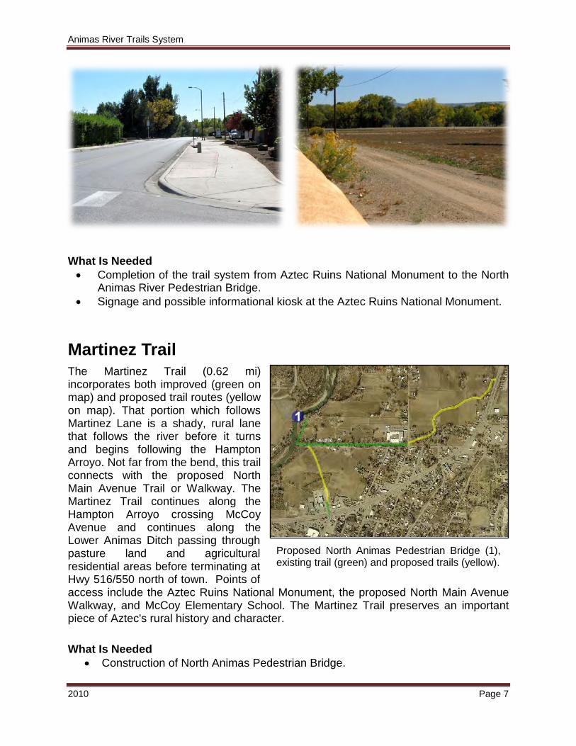
Martinez Trail The Martinez Trail (0.62 mi) incorporates both improved (green on map) and proposed trail routes (yellow on map). That portion which follows Martinez Lane is a shady, rural lane that follows the river before it turns and begins following the Hampton Arroyo. Not far from the bend, this trail connects with the proposed North Main Avenue Trail or Walkway. The Martinez Trail continues along the Hampton Arroyo crossing McCoy Avenue and continues along the Lower Animas Ditch passing through pasture land and agricultural residential areas before terminating at Hwy 516/550 north of town. Points of access include the Aztec Ruins National Monument, the proposed North Main Avenue Walkway, and McCoy Elementary School. The Martinez Trail preserves an important piece of Aztec's rural history and character. What Is Needed
• Construction of North Animas Pedestrian Bridge.
Proposed North Animas Pedestrian Bridge (1), existing trail (green) and proposed trails (yellow).
Animas River Trails System
2010 Page 8
• Development of the Lower Animas Ditch trail segment.
• Trail kiosk and signage. • Parking area and other
trail facilities. • Finalizing of the North
Main Avenue Walkway to establish connectivity to Historic Aztec.
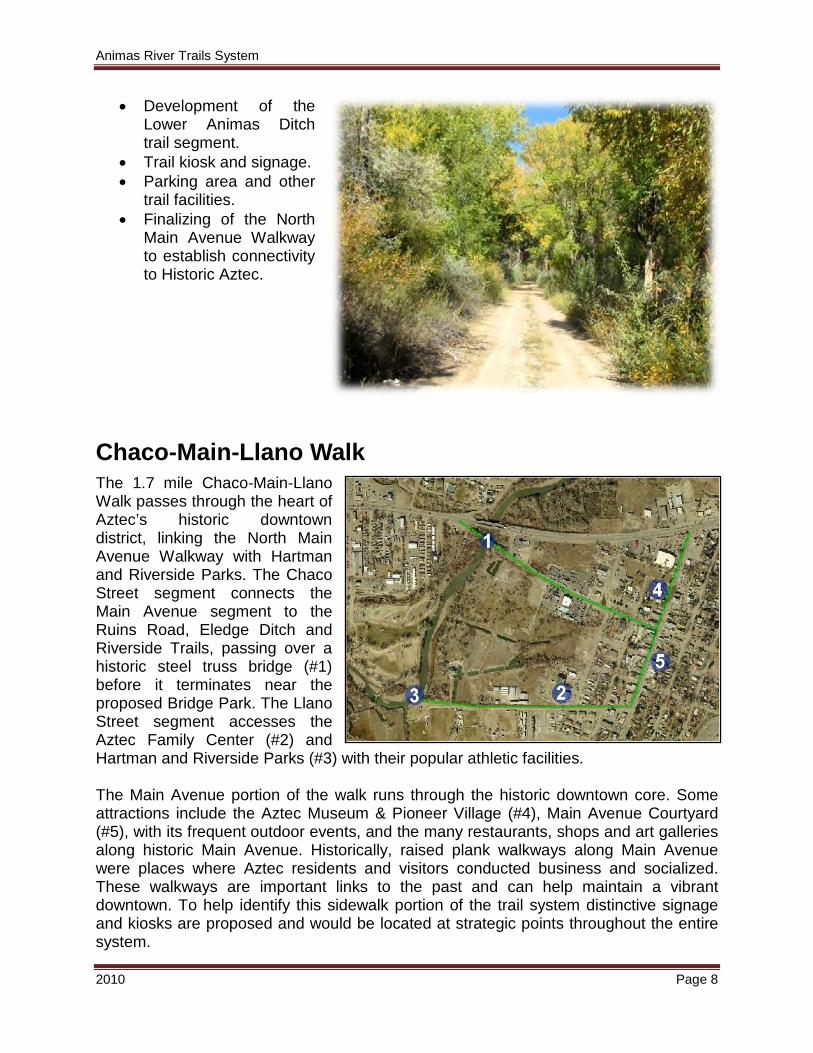
Chaco-Main-Llano Walk The 1.7 mile Chaco-Main-Llano Walk passes through the heart of Aztec’s historic downtown district, linking the North Main Avenue Walkway with Hartman and Riverside Parks. The Chaco Street segment connects the Main Avenue segment to the Ruins Road, Eledge Ditch and Riverside Trails, passing over a historic steel truss bridge (#1) before it terminates near the proposed Bridge Park. The Llano Street segment accesses the Aztec Family Center (#2) and Hartman and Riverside Parks (#3) with their popular athletic facilities. The Main Avenue portion of the walk runs through the historic downtown core. Some attractions include the Aztec Museum & Pioneer Village (#4), Main Avenue Courtyard (#5), with its frequent outdoor events, and the many restaurants, shops and art galleries along historic Main Avenue. Historically, raised plank walkways along Main Avenue were places where Aztec residents and visitors conducted business and socialized. These walkways are important links to the past and can help maintain a vibrant downtown. To help identify this sidewalk portion of the trail system distinctive signage and kiosks are proposed and would be located at strategic points throughout the entire system.
Animas River Trails System
2010 Page 9
What Is Needed • Historic designed signage. • Historic plaques. • Kiosks at key locations.
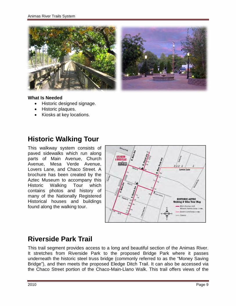
Historic Walking Tour This walkway system consists of paved sidewalks which run along parts of Main Avenue, Church Avenue, Mesa Verde Avenue, Lovers Lane, and Chaco Street. A brochure has been created by the Aztec Museum to accompany this Historic Walking Tour which contains photos and history of many of the Nationally Registered Historical houses and buildings found along the walking tour.
Riverside Park Trail This trail segment provides access to a long and beautiful section of the Animas River. It stretches from Riverside Park to the proposed Bridge Park where it passes underneath the historic steel truss bridge (commonly referred to as the “Money Saving Bridge”), and then meets the proposed Eledge Ditch Trail. It can also be accessed via the Chaco Street portion of the Chaco-Main-Llano Walk. This trail offers views of the
Animas River Trails System
2010 Page 10
Animas River in a tranquil wooded setting. It can be easily accessed from Riverside and Hartman Parks and is ideal for fishing, hiking, bicycling and family oriented recreation. The trail has recently been upgraded in several areas to concrete and allows for ADA use along most of the trail along the river’s edge and across the pedestrian bridge. It is planned that this trail segment along with the proposed Eledge Ditch Trail will connect to the Townsend Wildlife Nature Refuge located 0.40 miles west of Riverside Park. What Is Needed
• Continued improvements of trail.
• Installation of kiosks. • Uniformity in signage. • Possibly more rest stops or other trail features such as pet clean-up stations.
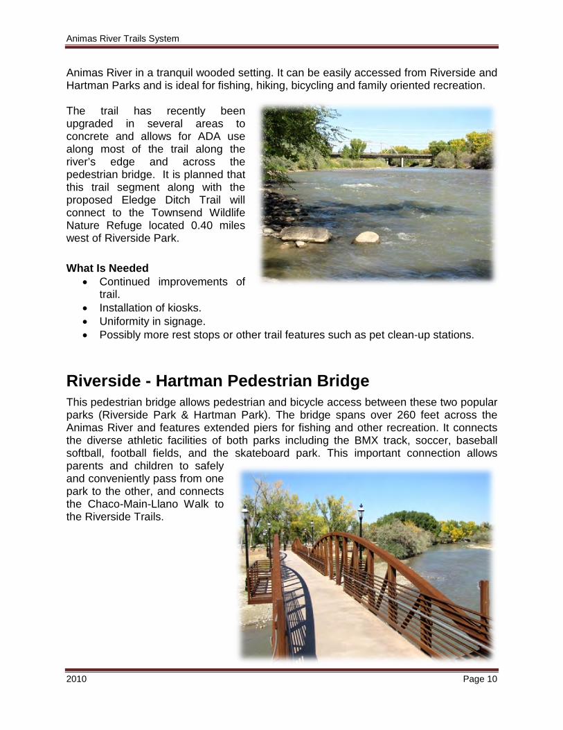
Riverside - Hartman Pedestrian Bridge This pedestrian bridge allows pedestrian and bicycle access between these two popular parks (Riverside Park & Hartman Park). The bridge spans over 260 feet across the Animas River and features extended piers for fishing and other recreation. It connects the diverse athletic facilities of both parks including the BMX track, soccer, baseball softball, football fields, and the skateboard park. This important connection allows parents and children to safely and conveniently pass from one park to the other, and connects the Chaco-Main-Llano Walk to the Riverside Trails.
Animas River Trails System
2010 Page 11
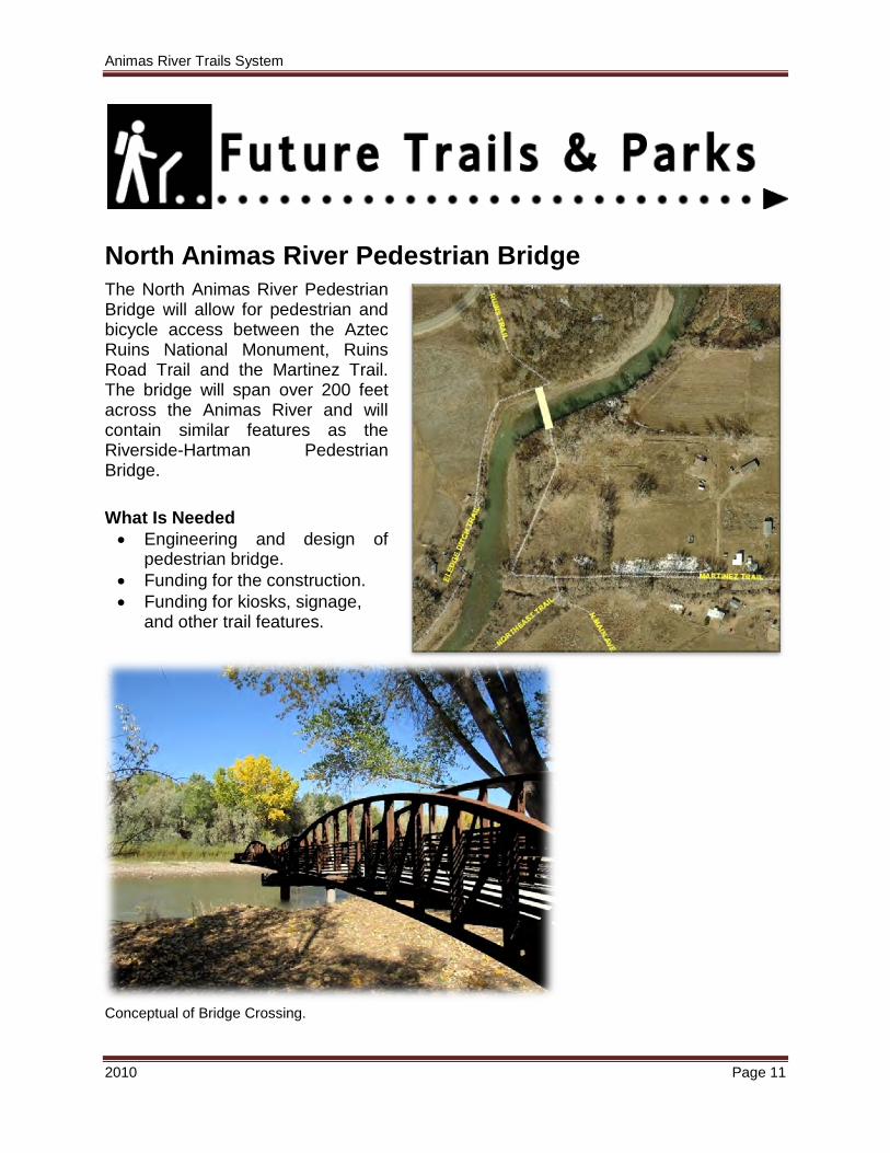
North Animas River Pedestrian Bridge The North Animas River Pedestrian Bridge will allow for pedestrian and bicycle access between the Aztec Ruins National Monument, Ruins Road Trail and the Martinez Trail. The bridge will span over 200 feet across the Animas River and will contain similar features as the Riverside-Hartman Pedestrian Bridge. What Is Needed • Engineering and design of
pedestrian bridge. • Funding for the construction. • Funding for kiosks, signage,
and other trail features.
Conceptual of Bridge Crossing.
Animas River Trails System
2010 Page 12
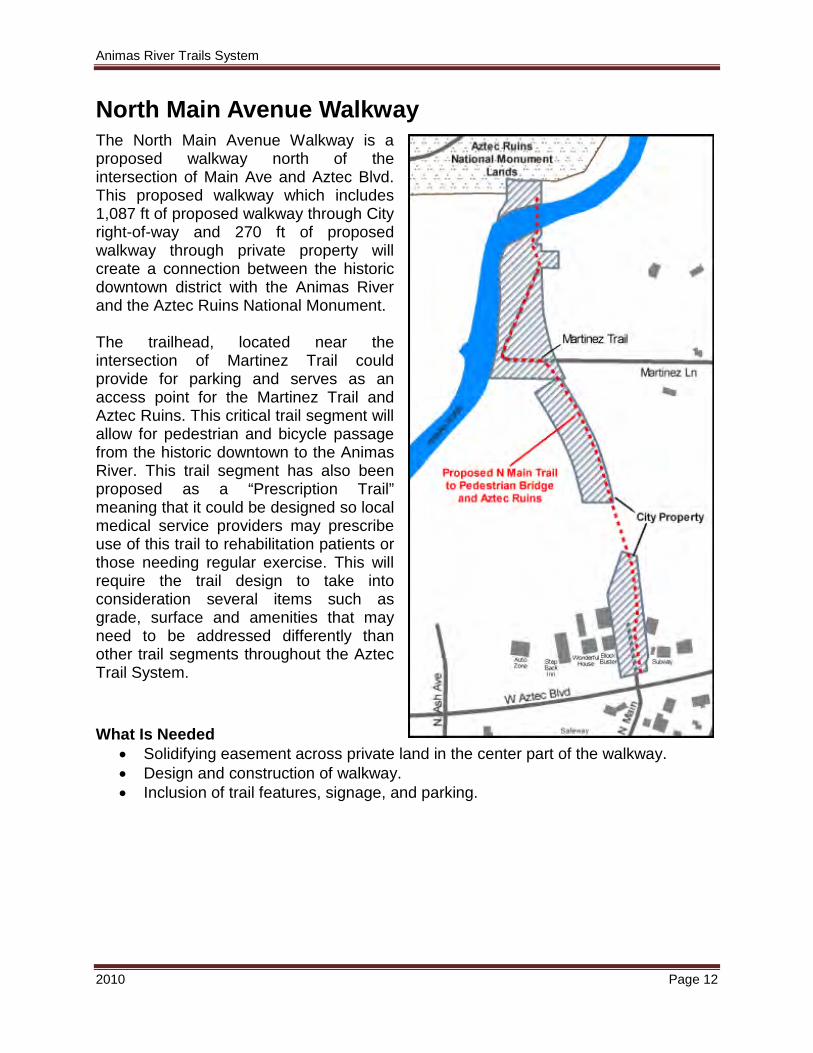
North Main Avenue Walkway The North Main Avenue Walkway is a proposed walkway north of the intersection of Main Ave and Aztec Blvd. This proposed walkway which includes 1,087 ft of proposed walkway through City right-of-way and 270 ft of proposed walkway through private property will create a connection between the historic downtown district with the Animas River and the Aztec Ruins National Monument. The trailhead, located near the intersection of Martinez Trail could provide for parking and serves as an access point for the Martinez Trail and Aztec Ruins. This critical trail segment will allow for pedestrian and bicycle passage from the historic downtown to the Animas River. This trail segment has also been proposed as a “Prescription Trail” meaning that it could be designed so local medical service providers may prescribe use of this trail to rehabilitation patients or those needing regular exercise. This will require the trail design to take into consideration several items such as grade, surface and amenities that may need to be addressed differently than other trail segments throughout the Aztec Trail System. What Is Needed
• Solidifying easement across private land in the center part of the walkway. • Design and construction of walkway. • Inclusion of trail features, signage, and parking.
Animas River Trails System
2010 Page 13
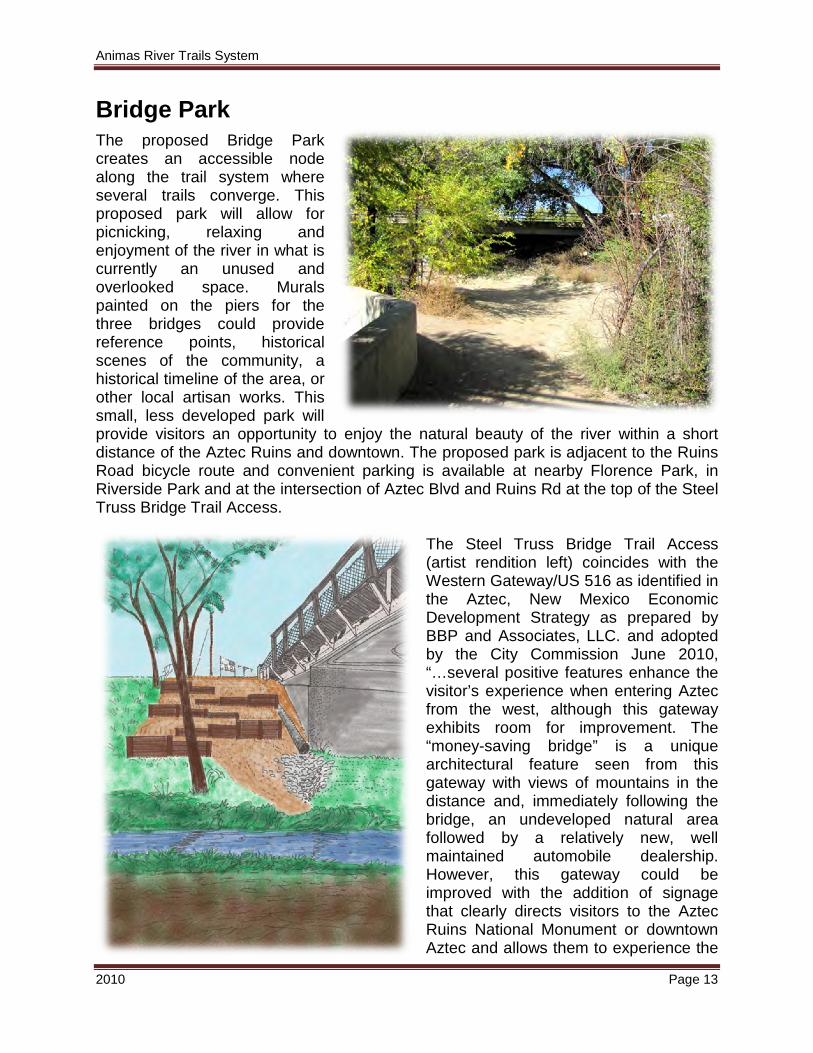
Bridge Park The proposed Bridge Park creates an accessible node along the trail system where several trails converge. This proposed park will allow for picnicking, relaxing and enjoyment of the river in what is currently an unused and overlooked space. Murals painted on the piers for the three bridges could provide reference points, historical scenes of the community, a historical timeline of the area, or other local artisan works. This small, less developed park will provide visitors an opportunity to enjoy the natural beauty of the river within a short distance of the Aztec Ruins and downtown. The proposed park is adjacent to the Ruins Road bicycle route and convenient parking is available at nearby Florence Park, in Riverside Park and at the intersection of Aztec Blvd and Ruins Rd at the top of the Steel Truss Bridge Trail Access.
The Steel Truss Bridge Trail Access (artist rendition left) coincides with the Western Gateway/US 516 as identified in the Aztec, New Mexico Economic Development Strategy as prepared by BBP and Associates, LLC. and adopted by the City Commission June 2010, “…several positive features enhance the visitor’s experience when entering Aztec from the west, although this gateway exhibits room for improvement. The “money-saving bridge” is a unique architectural feature seen from this gateway with views of mountains in the distance and, immediately following the bridge, an undeveloped natural area followed by a relatively new, well maintained automobile dealership. However, this gateway could be improved with the addition of signage that clearly directs visitors to the Aztec Ruins National Monument or downtown Aztec and allows them to experience the
Animas River Trails System
2010 Page 14
views from the “money-saving bridge.” This proposed signage should include identification of trail parking and access adjacent to the Steel Truss Bridge. What Is Needed
• Construction of Steel Truss Bridge Access (proposed for 2011). • Solidifying plan for park. • Funding for design and construction of park. • Inclusion of trail features, signage, and parking.
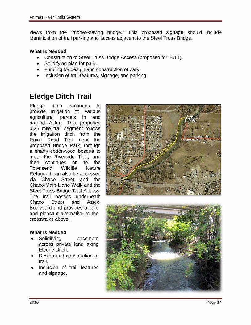
Eledge Ditch Trail Eledge ditch continues to provide irrigation to various agricultural parcels in and around Aztec. This proposed 0.25 mile trail segment follows the irrigation ditch from the Ruins Road Trail near the proposed Bridge Park, through a shady cottonwood bosque to meet the Riverside Trail, and then continues on to the Townsend Wildlife Nature Refuge. It can also be accessed via Chaco Street and the Chaco-Main-Llano Walk and the Steel Truss Bridge Trail Access. The trail passes underneath Chaco Street and Aztec Boulevard and provides a safe and pleasant alternative to the crosswalks above.
What Is Needed • Solidifying easement
across private land along Eledge Ditch.
• Design and construction of trail.
• Inclusion of trail features and signage.
Animas River Trails System
2010 Page 15
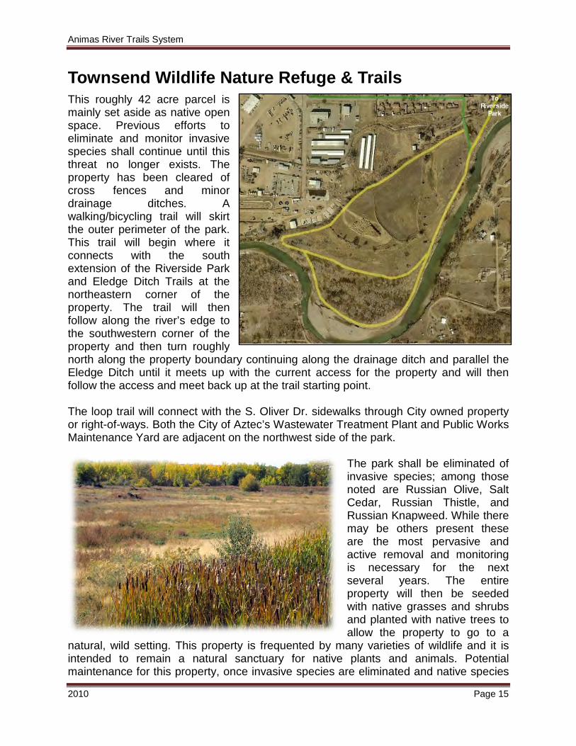
Townsend Wildlife Nature Refuge & Trails This roughly 42 acre parcel is mainly set aside as native open space. Previous efforts to eliminate and monitor invasive species shall continue until this threat no longer exists. The property has been cleared of cross fences and minor drainage ditches. A walking/bicycling trail will skirt the outer perimeter of the park. This trail will begin where it connects with the south extension of the Riverside Park and Eledge Ditch Trails at the northeastern corner of the property. The trail will then follow along the river’s edge to the southwestern corner of the property and then turn roughly north along the property boundary continuing along the drainage ditch and parallel the Eledge Ditch until it meets up with the current access for the property and will then follow the access and meet back up at the trail starting point. The loop trail will connect with the S. Oliver Dr. sidewalks through City owned property or right-of-ways. Both the City of Aztec’s Wastewater Treatment Plant and Public Works Maintenance Yard are adjacent on the northwest side of the park.
The park shall be eliminated of invasive species; among those noted are Russian Olive, Salt Cedar, Russian Thistle, and Russian Knapweed. While there may be others present these are the most pervasive and active removal and monitoring is necessary for the next several years. The entire property will then be seeded with native grasses and shrubs and planted with native trees to allow the property to go to a
natural, wild setting. This property is frequented by many varieties of wildlife and it is intended to remain a natural sanctuary for native plants and animals. Potential maintenance for this property, once invasive species are eliminated and native species
Animas River Trails System
2010 Page 16
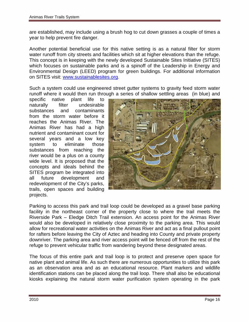
are established, may include using a brush hog to cut down grasses a couple of times a year to help prevent fire danger. Another potential beneficial use for this native setting is as a natural filter for storm water runoff from city streets and facilities which sit at higher elevations than the refuge. This concept is in keeping with the newly developed Sustainable Sites Initiative (SITES) which focuses on sustainable parks and is a spinoff of the Leadership in Energy and Environmental Design (LEED) program for green buildings. For additional information on SITES visit: www.sustainablesites.org. Such a system could use engineered street gutter systems to gravity feed storm water runoff where it would then run through a series of shallow settling areas (in blue) and specific native plant life to naturally filter undesirable substances and contaminants from the storm water before it reaches the Animas River. The Animas River has had a high nutrient and contaminant count for several years and a low key system to eliminate those substances from reaching the river would be a plus on a county wide level. It is proposed that the concepts and ideals behind the SITES program be integrated into all future development and redevelopment of the City’s parks, trails, open spaces and building projects. Parking to access this park and trail loop could be developed as a gravel base parking facility in the northeast corner of the property close to where the trail meets the Riverside Park – Eledge Ditch Trail extension. An access point for the Animas River would also be developed in relatively close proximity to the parking area. This would allow for recreational water activities on the Animas River and act as a final pullout point for rafters before leaving the City of Aztec and heading into County and private property downriver. The parking area and river access point will be fenced off from the rest of the refuge to prevent vehicular traffic from wandering beyond these designated areas. The focus of this entire park and trail loop is to protect and preserve open space for native plant and animal life. As such there are numerous opportunities to utilize this park as an observation area and as an educational resource. Plant markers and wildlife identification stations can be placed along the trail loop. There shall also be educational kiosks explaining the natural storm water purification system operating in the park
Animas River Trails System
2010 Page 17
utilizing the plant life and the negative impacts of allowing unfiltered storm water to join the river.
It is the intent to have standardized signage along the trails system which can provide cultural, natural, and/or historic information pertinent to that particular area. There are three fundamental types of signage that will be utilized along the trail system:
1. Directional 2. Informational 3. Regulatory
Signage for access to the trail system shall also be incorporated into the various directional road signs placed throughout the roadways within Aztec. Aside from standard trail signs, several kiosks are planned for locations at the North Animas River Pedestrian Bridge, Riverside-Hartman Park, Tiger Park, proposed Bridge Park, and proposed Townsend Wildlife Nature Refuge. These kiosks will contain interpretive panels with benches, trash receptacles, etc. Conceptually the informational panels could contain the following information for each location:
• Both sides of the pedestrian bridge, each would act as a gateway to the sites and locations on the opposite side of the Animas River. This important connection provides river access to Aztec Ruins National Monument, enhances the experience of visiting the adjacent national monument and encourages trail use.
Animas River Pedestrian Bridge
o East side would have a panel focusing on the Old Spanish Trail; o West side would have a panel focusing on the Aztec Ruins National
Monument • Map of other city parks and trails system. • Historical information on Aztec Ruins and Old Spanish Trail.
• Both sides of the pedestrian bridge. Riverside-Hartman Park
• Map of other city parks and trails system. • Rules & regulations on use of the parks.
• Entrance to the park. Tiger Park
• Rules & regulations for use of the reservoir.
Animas River Trails System
2010 Page 18
• Map of other city parks and trails system.
• Map of other city parks and trails system. Proposed Bridge Park
• History of bridge crossings at this location. • History of how the Animas River was named.
• Nature key to local wildlife and plants. Proposed Townsend Wildlife Refuge
• Map of other city parks and trails system. What Is Needed
• Conceptual design to function as a template for sign panels. • Conceptual design to function as a template for kiosks and informational sign
structures. • Corporate or private donations for funding sign and kiosk materials.
Animas River Trails System
2010 Page 19
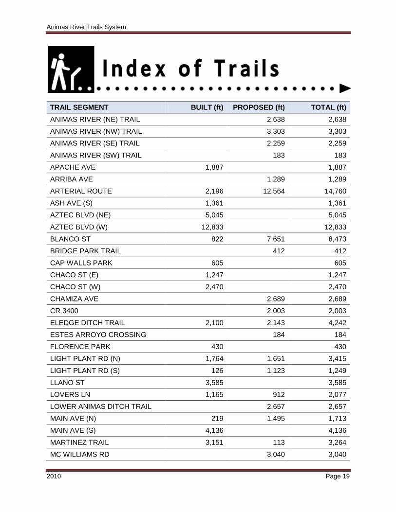
TRAIL SEGMENT BUILT (ft) PROPOSED (ft) TOTAL (ft) ANIMAS RIVER (NE) TRAIL 2,638 2,638 ANIMAS RIVER (NW) TRAIL 3,303 3,303 ANIMAS RIVER (SE) TRAIL 2,259 2,259 ANIMAS RIVER (SW) TRAIL 183 183 APACHE AVE 1,887 1,887 ARRIBA AVE 1,289 1,289 ARTERIAL ROUTE 2,196 12,564 14,760 ASH AVE (S) 1,361 1,361 AZTEC BLVD (NE) 5,045 5,045 AZTEC BLVD (W) 12,833 12,833 BLANCO ST 822 7,651 8,473 BRIDGE PARK TRAIL 412 412 CAP WALLS PARK 605 605 CHACO ST (E) 1,247 1,247 CHACO ST (W) 2,470 2,470 CHAMIZA AVE 2,689 2,689 CR 3400 2,003 2,003 ELEDGE DITCH TRAIL 2,100 2,143 4,242 ESTES ARROYO CROSSING 184 184 FLORENCE PARK 430 430 LIGHT PLANT RD (N) 1,764 1,651 3,415 LIGHT PLANT RD (S) 126 1,123 1,249 LLANO ST 3,585 3,585 LOVERS LN 1,165 912 2,077 LOWER ANIMAS DITCH TRAIL 2,657 2,657 MAIN AVE (N) 219 1,495 1,713 MAIN AVE (S) 4,136 4,136 MARTINEZ TRAIL 3,151 113 3,264 MC WILLIAMS RD 3,040 3,040
Animas River Trails System
2010 Page 20
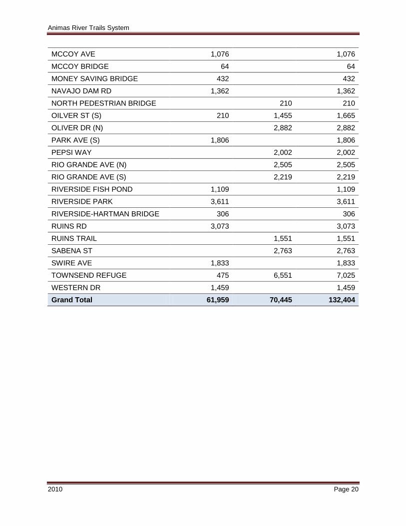
MCCOY AVE 1,076 1,076 MCCOY BRIDGE 64 64 MONEY SAVING BRIDGE 432 432 NAVAJO DAM RD 1,362 1,362 NORTH PEDESTRIAN BRIDGE 210 210 OILVER ST (S) 210 1,455 1,665 OLIVER DR (N) 2,882 2,882 PARK AVE (S) 1,806 1,806 PEPSI WAY 2,002 2,002 RIO GRANDE AVE (N) 2,505 2,505 RIO GRANDE AVE (S) 2,219 2,219 RIVERSIDE FISH POND 1,109 1,109 RIVERSIDE PARK 3,611 3,611 RIVERSIDE-HARTMAN BRIDGE 306 306 RUINS RD 3,073 3,073 RUINS TRAIL 1,551 1,551 SABENA ST 2,763 2,763 SWIRE AVE 1,833 1,833 TOWNSEND REFUGE 475 6,551 7,025 WESTERN DR 1,459 1,459 Grand Total 61,959 70,445 132,404