Embed Size (px)
Citation preview

Northeast Historical Archaeology
Volume 24 Article 6
1995
The Archaeology of Provincial Officers' Huts atCrown Point State Historic SiteCharles L. Fisher
Follow this and additional works at: http://orb.binghamton.edu/neha
Part of the Archaeological Anthropology Commons
This Article is brought to you for free and open access by The Open Repository @ Binghamton (The ORB). It has been accepted for inclusion inNortheast Historical Archaeology by an authorized editor of The Open Repository @ Binghamton (The ORB). For more information, please [email protected].
Recommended CitationFisher, Charles L. (1995) "The Archaeology of Provincial Officers' Huts at Crown Point State Historic Site," Northeast HistoricalArchaeology: Vol. 24 24, Article 6.https://doi.org/10.22191/neha/vol24/iss1/6 Available at: http://orb.binghamton.edu/neha/vol24/iss1/6

The Archaeology of Provincial Officers' Huts at Crown Point StateHistoric Site
Cover Page FootnoteThe investigations reported here were undertaken at the request of Cheryl Gold, Historic PreservationSupervisor for the Saratoga Capital Region of the New York State Office of Parks, Recreation, and HistroicPreservation. Greg Furness and Tim Titus of Crown Point State Histroic Site provided several importantrefernces. The field work was conducted by the Archaeology Unit of the Bureau of Historic Sites.
This article is available in Northeast Historical Archaeology: http://orb.binghamton.edu/neha/vol24/iss1/6

Northeast HistoriCJJI Archaeology/Vol. 24, 1995 65
The Archaeology of Provincial Officers' Huts at Crown Point State Historic Site
Charles L. Fisher
Archaeological survey of the site of a proposed maintenance building at Crown Point State Historic Site located the remains of three historic structures, identified as temporary housing of 18th-century soldiers during the initial construction of the extensive British fortifications, which began in 1759. These archaeological features and associated objects are evidence of both the material conditions of the soldiers and the social relationships among them. The spatial organization of the encampment separated the Provincial regiments from the British regulars. Within a single Provincial regiment's camp, the officers' huts were separated from their troops. The small objects recovered archaeologically are viewed in terms of their role in separating social groups of different ranks while uniting men of similar rank. In addition, the archaeological evidence suggests that the Provincials' camps were not "irregular" and "chaotic. " By 1759, the Provincials' encampments reflect an increasingly professional or Bn'tish attitude.
L'etude archeologique de /'emplacement d'un eventuel biHiment d'entretien au site historique d'Etat de Crown Point a localise les vestiges de trois ouvrages historiques, identifies comme servant de logement temporaire aux soldats durant Ia construction, commencee en 1759, des vastes fortifications bn'tanniques. Ces elements archeologiques et les objets connexes sont revelateurs des conditions de vie materielles des soldats et des relations sociales existant entre eux. L'organisation spatiale du camp separait les regiments provinciaux des reguliers britianniques. Au sein du meme camp d'un regiment provincial, les baraques des officiers etaient separees des troupes. Les petits objets retrouves par l' archeologie sont vus en fonction de ce qu'ils concouraient ii separer les groupes sociaux de rang different tout en unissant les hommes de meme rang. En outre, il semble, d'apres les donnees archeologiques, que les camps des Provinciaux n'etaient pas "irreguliers" ni chaotiques. En 1759, les camps provinciaux refietent une attitude de plus en plus professionnelle ou britannique.
Introduction
The history of the colonial wars in North America is not simply the chronology of battles and campaigns (Shy 1965; Higgenbotham 1983). Armies are social products that reflect the processes and conditions of their societies. Military sites are artifacts that contain evidence of these social processes, including the contradictions of the society that created them. During the 18th century, the British colonial empire united distant and diverse populations in the various struggles against its rivals. At the same time, internal conflicts intensified.
The relationships between the British Army and the Provincials, and between the Provincial officers and soldiers, were the subject of recent archaeological investigations at Crown Point State Historic Site. The remains of
three historical structures were located during survey, and two of these were explored further. Archaeological and historical evidence indicates that these features are the remains of the temporary housing of the 18th-century soldiers who constructed the extensive British fortifications at Crown Point. These features provide direct material evidence of the people who built the fortifications that can be compared to that of the fort's later occupants. Documenting the variation in the material conditions of the fort's different occupants is an essential part of interpreting the historical experience at this site.
Crown Point State Historic Site contains material evidence of 18th-century French, British, and American military activities. The remains of a French fort (1734) and a British fort (1759) make Crown Point one of the most

New York
New
Vermont I / I
New Hampshire
L Oemers '/80
I '- ~\K\ /(/ - <; K "' I ,.r.,.N, _//~J II
D
1SCAL.( 162~ ~ 0
([] v
CCNTOUR INT(RVAL ZOO FEE T (Dohom <1 .....on WoO le.,.l) L Demers 7/80
Figure 1. Map of the area with the location of Crown Point State Historic Site. North is to the top. (Drawing by Linda Demers.)
a. a.
n
~ cl' a
I ~ §_ :t " ~ ~

extensive archaeological sites in New York State. "The ruins at Crown Point...are among the very few remaining examples of pre-Revolutionary military construction in the United States, and have been designated National Historic Landmarks by the Department of the Interior" (Furness and Titus 1985: 1).
The site is located on the northern end of a peninsula extending into Lake Champlain, in Essex County, New York (FIG. 1). The political control of this location was critical because it was on the colonial route between Albany and Montreal. In addition, French military patrols from Fort St. Frederic at Crown Point often attacked English settlements in New York and New England, therefore, Fort St. Frederic was the object of several unsuccessful military expeditions by British and Provincial soldiers before troops under General Amherst captured the fort in 1759.
During the initial British occupation of the remains of Fort St. Frederic, they began construction of a system of fortifications that covered over 3.5 sq mi. This complex consisted of a large fort, three redoubts, a series of blockhouses, and a network of roads. In 1759, the workforce included almost 8,000 soldiers from Massachusetts, Rhode Island, Connecticut, and New York.
Crown Point and its dependencies were the most ambitious military construction projects undertaken up to that time in British North America. The installation was intended as the final answer to French incursions by way of Lake Champlain. The main fortification was a pentagonal work covering six acres, mounting 105 cannon, and was designed to accommodate 4000 men. (Furness and Titus 1985: 9)
After the signing of the Treaty of Paris in 1763, this fortification was no longer necessary to protect the British colonies from the French. At Crown Point, the absence of this military threat resulted in an expanded civilian settlement that took advantage of this location. The British fort, burned accidentally in 1773, was captured by the American army at the beginning of the Revolutionary War. After approximately 1.5 years of American occupation Crown Point returned to British control. After
Northeast HistoriCJJI ArchaeologyNol. 24, 1995 67
the Revolutionary War, Crown Point became the property of New York State.
Both British regular and Provincial troops were involved in the occupation and construction of the Crown Point fortifications. The structure of the British army reflected the strict class divisions of British society. Officers, who purchased their commissions, were from the nobility. The cost of a commission was well beyond the resources available to the middle class. The aid of powerful patrons in government, who expected payments for their services, was necessary to obtain a commission. This maintained the officer ranks as a respectable place of employment for the younger sons of the British elite. In order to obta in a rank in the British army, social standing and political connections were as necessary as financial wealth.
British soldiers, however, were drawn from the opposite end of the social and economic scale. Hired European troops augmented the unemployed urban workers and the poor who constituted the British military force. British class divisions were emphasized in the military, because the middle class was largely absent.
The American military organization, while based upon the British system, reflected the greater social mobility of colonial society. Social stratification was present and important to the military structure in the colonies, however.
The Provincial armies, or expeditionary forces, differed from the militia, which was established to protect settlements. The militia was associated with the middle class property owners who fought to protect their communities and landholdings. The expeditionary forces were created for specific campaigns, such as Amherst's effort in 1759 to take Crown Point from the French.
The Provincial officers were appointed by governors and were responsible for recruiting their own men. Officers, at least at the highest ranks, came from the highest social classes. In a comparison of the occupations of Massachusetts Provincials by rank, Anderson (1984) found the proportion of sold iers that were identified as laborers increased while the proportion of non-manual workers decreased with decreases in rank.

68 Crown Point Officers' Huts/Fisher
The Provincial army contained the same class divisions as the colonial society, but they were not as sharply defined as in the British army. The troops were made up largely of the poor, who were controlled by the wealthy officers . The colonial soldier was temporarily available for military service and not part of a permanent underclass (Anderson 1984).
Archaeological studies at Crown Point State Historic Site have identified material correlates of the rigid status structure of the British military. The types of construction material employed in the barracks' fireplaces and floors were "significant indicators" of the status differences between officers and enlisted men (Feister 1984a: 106). Brick fireplaces were present in the Officers' barracks, while the Soldiers' Barracks had stone fireplaces. "The flooring in the Officers' Barracks was of tiles, a more expensive material... as contrasted with the cheaper brick floors in the Soldiers' Barracks" (Feister 1984a: 106).
Historians (Martin and Lender 1982) and archaeologists (Deetz 1977) have noted the relationship between the American Revolution and the anglicization of the colonists during the 18th century. Archaeology at Revolutionary War encampments has raised issues regarding settlement patterns, architecture, sanitary practices, and other aspects of material conditions that may be explored through investigations at earlier 18th-century military sites of the French and Indian War (Fisher 1983; Seidel1983; Parrington 1979-1980; Lenik 1987).
Numerous military sites of the 1750s and 1760s are known from the Hudson River and Lake Champlain valleys, but many of these have been damaged or destroyed by development and looting prior to any scientific study. Rescue excavations at the site of Fort Gage at Lake George were reported by Feister and Huey (1985). This was the site of a 1758 Provincial redoubt that was totally destroyed by the construction of a motel in 1975. The investigators pointed out the importance of this and similar sites that reveal the colonists' military experience in the British campaigns against the French. The fieldwork at Fort Gage located 37 trash pits that contained artifacts, but it was not possible to determine whether
they were located inside or outside of buildings due to the bulldozer disturbance. An absence of ceramics in this collection was interpreted as the result of the short-term occupation by the expeditionary forces.
More recently, archaeological surveys and controlled excavations have taken place at the British camp on Rogers Island (Starbuck 1992, 1993). Despite years of large-scale artifact looting, remains of the extensive British and American camp of the French and Indian War were located. This study was undertaken for the property owners as part of a management plan, "thus permitting the property owners to effectively manage and protect historical resources while proceeding with modern development" (Starbuck 1993: 37).
The results of this new study included locating and recording a Rangers' or Provincial soldiers' shelter. The remains of this square building, measuring 11 ft on a side, consisted of a narrow trench that contained the ends of vertical boards, post molds, and the scattered brick remains of two fireplaces. Artifacts from this hut included nails, lead sprue, stoneware, burnt animal bones, and a silver shoe buckle.
Another fireplace was located at Rogers Island that may have been part of an officers' house or hut. This interpretation is based on " ... the high quality of the fireplaces's construction and the presence of a wood floor. .. " (Starbuck 1993: 19).
The identification of the material correlates of wealth and rank and the investigation of the earlier military experience of the Revolutionary War soldiers are objectives of this study. Another goal, however, is the description of the rna terial world the soldiers constructed at Crown Point. The pattern of military settlement, the architectural remains of soldiers' huts, and the smaller artifacts found at this site provide a material basis for the study of the military encampment as a product of the existing social relations. In this manner, the encampment maintained and modified the colonial social structure.
Archaeological Fieldwork
Between 1985 and 1988, archaeologists from the Bureau of Historic Sites conducted an
CROWN POINT STATE HISTORIC SITE
ARCHEOLOGICAL SURVEY OF THE
PROPOSED MAINTENANCE BUIL DING SITE
• TEIT P't.WATICWS
I .. IO 'Ilf _,
_.:...,.~: ............- • ruTUM:t . : . .
• • • t
. . -·~
""""'~
Northeast HistoriCill Arclwology/Vol. 24, 1995 69
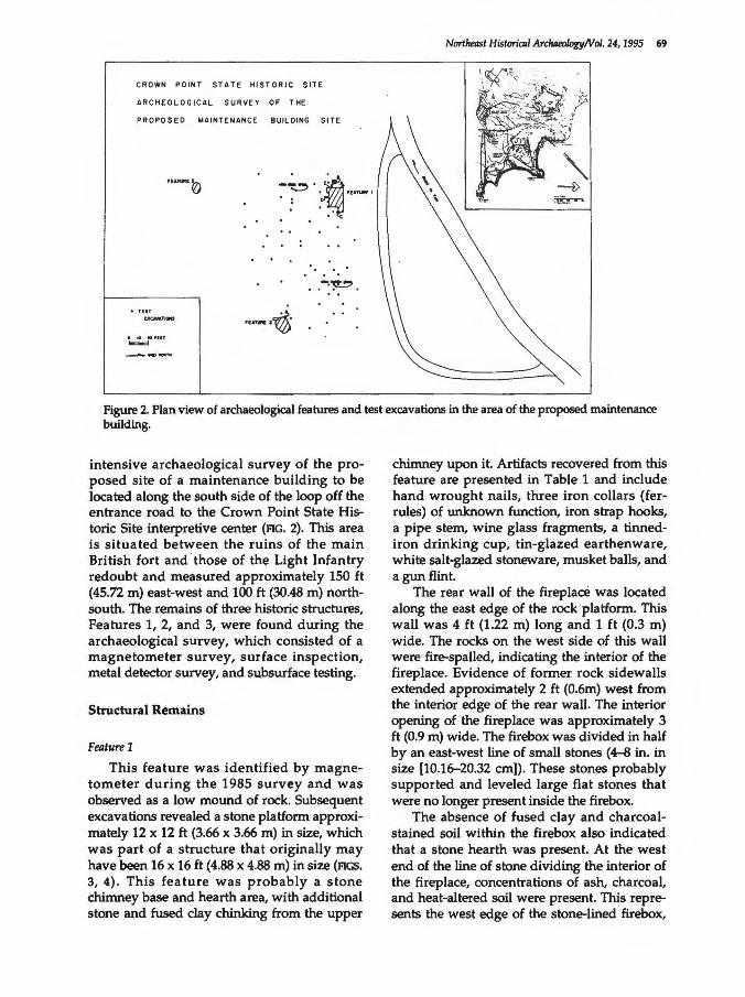
Figure 2. Plan view of archaeological features and test excavations in the area of the proposed maintenance building.
intensive archaeological survey of the proposed site of a maintenance building to be located along the south side of the loop off the entrance road to the Crown Point State Historic Site interpretive center (PIG. 2). This area is situated between the ruins of the main British fort and · those of the Light Infantry redoubt and measured approximately 150 ft (45.72 m) east-west and 100ft (30.48 m) northsouth. The remains of three historic structures, Features 1, 2, and 3, were found during the archaeological survey, which consisted of a magnetometer survey, surface inspection, metal detector survey, and subsurface testing.
Structural Remains
Feature 1
This feature was identified by magnetometer during the 1985 survey and was observed as a low mound of rock. Subsequent excavations revealed a stone platform approximately 12 x 12 ft (3.66 x 3.66 m) in size, which was part of a structure that originally may have been 16 x 16ft (4.88 x 4.88 m) in size (PIGS. 3, 4). This feature was probably a stone chimney base and hearth area, with additional stone and fused clay chinking from the upper
chimney upon it. Artifacts recovered from this feature are presented in Table 1 and include hand wrought nails, three iron collars (ferrules) of unknown function, iron strap hooks, a pipe stem, wine glass fragments, a tinnediron drinking cup, tin-glazed earthenware, white salt-glazed stoneware, musket balls, and a gun flint.
The rear wall of the fireplace was located along the east edge of the rock platform. This wall was 4 ft (1.22 m) long and 1 ft (0.3 m) wide. The rocks on the west side of this wall were fire-spalled, indicating the interior of the fireplace. Evidence of former rock sidewalls extended approximately 2 ft (0.6m) west from the interior edge of the rear wall. The interior opening of the fireplace was approximately 3 ft (0.9 m) wide. The firebox was divided in half by an east-west line of small stones (4-a in. in size [10.16-20.32 em)). These stones probably supported and leveled large flat stones that were no longer present inside the firebox.
The absence of fused clay and charcoalstained soil within the firebox also indicated that a stone hearth was present. At the west end of the line of stone dividing the interior of the fireplace, concentrations of ash, charcoal, and heat-altered soil were present. This represents the west edge of the stone-lined firebox,

+
+"'"'
+
+
+
+
+ .. ..,
Figure 3. Plan view of Feature l.
lr 0
I L ___ _ I ... M
_j
~
-- -----~Estimated ,-..,.,.D Building Outline
trrfiootij
4¥Q Q
oDflo oO 0
D
";)
<!
0 0 CJ
b "'o " \) /)
c,,_,_
Cro"'n P9int State Historic Site
P":f>c~ Maintenanc., ouildin, Site
F£,o. TUR.£ 1-Archoeo~Ofical Plan Y;.,,., 1988
\J ~::::_ ,.,_
6-"' ... . .... p ,......,..,
c ::::0··
;:§
Q g cl' ~·
~ § i ;;;-
~ rr

Northeilst Historiall Arcluleology/Vol. 24, 1995 71
Figure 4. Feature 1, with sod partially removed, during initial exploration, facing southwest.
Table 1. Artifacts from Feature 1. Artifact group #fragments #objects
Kitchen tin-glazed earthenware punch bowl 283 1 white salt-glazed stoneware saucer 15 1 wine bottle 1 1 flask 18 1 glassware 14 2 iron cup NA 1 pothook 2 1
Architectural nails 151 NA staple 1 1 ferrules 3 NA
Arms gunflints 2 2 lead balls 2 2 lead casting 2 NA
Clothing button 1 1
Tobacco Pipe pipestem 1 1
Activity pick axe 1 1 iron rod 1 NA iron scrap NA NA
Calcined bone 829 NA

72 Crown Point Officers' Huts/Fisher
about 30-36 in. (76.2-91.44 em) west of the interior of the rear wall of the fireplace.
An iron collar was present about 40 in. west of the north half of the fireplace. This ferrule was surrounded by ash and heat-altered soil, and the interior was filled with charcoalstained soil, suggesting that the collar surrounded a wooden, vertically placed post that burned. Another ferrule was found in excavation about 32 in. (81.28 em) west of the interior of the rear wall of the fireplace, among the displaced southern wing wall stones. A third ferrule was found during the initial clearing of this feature. The placement of the two collars in front of the fireplace suggests they may represent fireplace or cooking furniture, possibly a roasting spit or fireplace crane (FIG. 5).
In addition to the approximately square rock platform of Feature 1, a line of irregular rocks extended east from the northeast corner of Feature 1 for 8 ft (2.44 m). They were interpreted as a fallen chimney, since the rocks were irregular in size, location, and distribution. Excavations north and south of this line of rock failed to produce any evidence of a structure's interior. The ash, charcoal, fused clay, and artifacts present to the west did not continue to the east of the rock wall, suggesting the rear wall of the fireplace was also the rear wall of the structure. The line of rock
to the northeast was probably a chimney that fell to the exterior of the former structure.
Feature 1-A
A small pit feature was located to the northwest of this hearth (FIG. 3). This pit, Feature 1-A, did not contain any artifacts, but a quantity of charcoal and burned soil was present. This pit is approximately 26 in. (66 em) east-west and 36 in. (91.44 em) north-south in size. It extends from 8 in. to a maximum of 18 in. (45.72 em) below the ground surface. This pit was not originally created for disposal of trash or ashes but for some other function. It may have been the source of chinking clay used in the hut construction, or it may have been a privy pit.
Feature 1-B
A larger pit feature (Feature 1-b) was found to the west of Feature 1 (FIG. 3). This feature is approximately 4 ft (1.22 m) north-south and at least 3 ft (0.91 m) west-east. The pit is basin-shaped and about 14-17 in. 35.6-43.18 em) deep below ground surface (FIG. 6). This pit contained burned soil, fragments of mammal teeth, a small piece of clear lead wine or bottle glass, and three sherds of light blue tin-glazed earthenware. Additional sherds of
Figure 5. Wrought iron ferrules/ collars found in the vicinity of Feature 1 fireplace. (Photograph by Joseph McEvoy.)

II
I pale brown clay II light yellow brown clay
Fea. B dk. brown and light yellow brown clay with fused clay.
Northeast Historical ArchaeologyNol. 24, 1995 73
---+s o 6 12 inches Jae I
Feo.B, level 2 light yellow brown and dk. brown clay
-- - - - - limits of excavation
Figure 6. Section drawing of the east wall of Feature 1-B.
tin-glazed earthenware, charcoal, and calcined bone were recovered from the topsoil above this pit. This appears to be redeposited fill because the charcoal concentration is mixed with the burned clay. This pit was not constructed originally to contain trash, but it was possibly dug for use as a privy or clay source. The material present here was in the pit fill and was possibly related to a secondary use of this feature.
Feature 1-C
Surface stones were present about 10 ft (3.02 m) to the east of the rock platform and may represent a support pier (FIG. 3). A test excavation revealed a small pit, approximately 3ft (.91 m) in diameter around a piece of limestone that is about 18 x 14 in. (.45 x .35 m) and about 10 in. (.25 m) thick. Small stones in the pit fill are wedged against and under this rock. On the north edge of this feature was a stack of three rocks resembling a support pier. This may be the remains of a small outbuilding, but no other evidence was uncovered in additional excavations there.
Feature 1-D
A trench was excavated on the south side of Feature 1 that located the south edge of the
former structure (FIG. 3). A band of charcoal and nails was found with a layer of small stones to the south, which may have been an exterior surface or drip line.
Feature 1-E
To the west of the stone platform, the subsoil was cut into by a shallow trench 2-4 in. (5.08-10.16 em) deep that contained charred wood and charcoal (FIG. 3). Calcined bone, tinglazed earthenware, and nails were found to the east of this cut line, suggesting the western edge of the structure associated with the hearth. Six pieces of charcoal and a sherd of white salt-glazed stoneware were recovered. In section, the shallow cut with charcoal and burned earth appeared on both the north and south walls of the trench. This may have been the location of a sleeper (a supporting wooden beam at the ground surface) from the western wall of the structure.
Feature 2
This feature was initially observed as a low rock mound with a shallow soil cover. During the 1988 field season, the entire rock feature was exposed in order to define the structural components of this feature (FIGS. 7, 8). The hearth and firebox were identified, and exca-

74 Crown Point Officers' Huts/Fisher
Figure 7. Plan view of Feature 2.
Figure 8. Feature 2 after excavation of rock rubble, facing west.
Crown Point State Historic Site
Proposed Maintenance Buildilw Site
fEATURE 2-Archaeolosicai Plan VIew 1988
nL'' '-
....... K ... Hilt ... 6 boflll-- · MII,..,..IIIGII
N ... C c:onWI

vated artifacts revealed some of the activities that occurred here. A list of the artifacts is presented in Table 2.
A raised rock platform of approximately 8 ft (east-west, 2.44 m) by 10 ft (north-south, 3.05 m) was present. This would have been inside a building estimated at 10 x 14 ft (3.05 x 4.27 m) in size. This north wall of this platform was the most clearly defined, comprised of dry-laid stone wall. It was about 12-18 in. (.3-.45 m) thick and 14ft (4.27 m) long. The fireplace was located in the center of the west side of this platform. A thick bed of charcoal and ash was present in the northwest interior comer of the fireplace. A single rock made up the south side of the north sidewall of the fireplace, extending 2 ft (.61 m) east from the rear wall and approximately 1 ft (0.3 m) in width. The north half of this side wall consisted of smaller stones that butted against the north wall of the platform for an entire side wall width of 2 ft (0.61 m). The firebox was slightly flared, with an interior width of 30 in. (0.76 m) against the
Table 2. Feature 2 artifacts. Artifact group
Kitchen wine bottle cast iron pot tin-glazed earthenware punch bowl
Architecture nails
Arms lead ball
Furniture pierced iron lantern
Tobacco Pipe pipe stem pipe bowls
Personal gray salt-glazed stoneware chamber pot canteen
Calcined bone
Burned nuts
Northeast Historical Archaeology/Val. 24, 1995 75
west (rear) wall and 36 in. (0.91 m) on the east side. The south sidewall was about 24 in. (0.61 m) wide, but was made of smaller stones. This wall was approximately 30 in . (0.76 m) long and in poor condition with many displaced stones. A flattened canteen and a number of fragments of a pierced tin lantern were found among these stones. The floor of the firebox consisted of three large, flat rocks with small stones between them.
On the east side of this rock platform, a single layer of relatively flat limestone rocks extended 6 ft (1.83 m) east beyond the fireplace, indicating a 14 x 10 ft (3.05 x 4.27 m) structure. These stones probably represent the interior floor, although the rocks do not resemble a well-laid paving. Present on this surface were calcined bone fragments, a cast iron pot fragment, and a musket ball.
On the west side of the fireplace, the rock platform supported the rear wall of the structure and probably the chimney. This wall was about 10 ft (3.05 m) long and 24 in. (0.61 m)
#fragments #objects
20 1 8 1
27 1
42 NA
1 1
18 1
6 1 2 1
4 1 NA 1
344 NA
2 NA

76 Crown Point Officers' Huts/Fisher
II II
- --IV
0 6 12 irches --•~E
I very dark grey-brown clay loam with rocks II dark brown clay loam with rocks Ill dark brown and yellow brown clay IV yellow brown clay
Fea. 2-A very dark grey-brown clay, charcoal, and bottle glass
------ limits of excavation
Figure 9. Section drawing of the north wall of Feature 2-A.
wide. It consisted of two rows of dry-laid stone with smaller rock fill between them. The size and construction of this wall suggest it was also the chimney base.
Feature 2-A
Recovered on the north side of the north wall at the west end of Feature 2 was a pit feature (FIG. 7). This pit was about 20 in. (0.51 m) long, 12 in. (0.3 m) wide, and about 8 in. (0.2 m) deep (FIG. 9). It was filled with a dark brown clay with charcoal, wood fibers, spots of burned clay, rocks, and a number of fragments of a dark green wine bottle. This pit was not created for the deliberate disposal of trash, but for some other purpose. The material present here comprised the pit fill and related to the secondary use of this feature.
Feature 2-B
A small trench was excavated along the south wall of the rock platform and provided an east-west section for measuring and
drawing the platform construction. This section drawing revealed a shallow builder' s excavation for the construction of the rock platform. This pit was only about 1 in. (2.54 em) deep on the west side of the platform, but it increased to about 5 in. (.12 m) deep in the center of the south edge of the platform. On the east side of the platform the soil layer representing the excavation fill was quite thin again. This suggests that the rectangular shaped rock platform was built in a shallow pit that was deeper in the center than along the edges. This provided either a level surface for construction or perhaps a shallow footing for increasing the stability of the structure.
Feature 3
This feature appeared to be a 10 x 20 ft (3.05 x 6.1 m) low stone mound to the south of the south edge of the survey area (FIG. 2). It is very similar to Features 1 and 2 and probably represents a similar structure. Since it is south of the proposed construction site, this feature was recorded but not excavated.

Northeast Historical ArchaeologyNol. 24, 1995 77
, · ........ IIIIOI[Pilill. t.YJ'~ ~~ad"( t.:-r.J.
- . ·-- ·~. ':· ~
- ~ /) -.. ... .. .. - ·' ~
.... _ ..
Figure 10. Detail of a map of the British encampment at Crown Point in 1759. The archaeological survey area IS located to the nght of the ridge and occupied by "Whitings" Provincials. North is to the top. (NYS Office of Parks, Recreation and Historic Preservation.)
Identification and Discussion
The archaeological features in the proposed maintenance building site are the remains of soldiers' temporary housing built during the initial years of British occupation of Crown Point. The location, spatial arrangements, material objects, and documentary evidence suggest these structures were occupied by officers of Whiting's 2nd Connecticut Regiment.
The Occupation Army
A map of the "Disposition of the English Army ... " in 1759 depicts an encampment of Colonel Nathan Whiting's Connecticut troops in the area of the archaeological survey (Anon. 1759) (FIG. 10). Whiting's regiment left Crown Point on Nov ember 14, 1759 (Amherst 1759-1763), their departure preceded by mutinies on November 1, 1759 of New Jersey, Massachusetts, New Hampshire, and New

78 Crown Point Officers' Huts/Fisher
York regiments, who refused to work beyond their enlistment. The New Jersey Provincials had to be surrounded by regular troops and forced to return to duty (Anderson 1984: 253). On November 13, a work detail of Connecticut and New Hampshire troops refused to continue road building until their meat ration was resumed (Anderson 1984: 253). The next day Whiting's Connecticut Regiment was sent home from Crown Point.
This regiment returned to Crown Point the next year and probably camped at this site in 1760-1761. In November of 1760, the stone barracks in the new fort were almost ready for occupation, but the wooden barracks were without chimneys. The officers were "obliged to live in their Hutts on the out side of the fort" (Amherst 1759-1763). Each officer had his own hut, but " ... they could not have lived the Winter, if they had not made great additions to them, many of them were not better than a single clabboard, or shingle" (Amherst 1759-1763). In 1761 there were 2,000 Connecticut troops at Crown Point, and 323 remained over the winter, but not at the location of these archaeological remains. In August 1761, the 2nd Connecticut Regiment moved its camp closer to the fort (Grant 1761). John Grant's orderly book of 1761 contains an encampment plan for Whiting's 2nd Connecticut Regiment, probably this new camp, which was closer to the fort.
In addition to identifying the regimental area studied, the 1759 map indicated the spatial organization of the military encampment at Crown Point. The main feature of this camp is the separation of the Provincial regiments from the British regulars. The Provincial camps are also enclosed, or surrounded, by regulars who are camped along the edges of the peninsula. Only Rangers are located outside of this perimeter of regulars.
This arrangement reveals several aspects of the 1759 occupation encampment. The British regulars are positioned to protect the point of land and the Provincial troops from an attack. This may indicate the low relative value of the Provincials as fighting soldiers in the minds of the British military establishment that designed the encampment.
The Provincials' value as the labor force for construction of the fort is evident in their cen-
tral position in the camp, near the fort and protected by the regulars. The British army also displayed an effort to contain and control the Provincials in the encampment.
The encampment plan is clear evidence of the ambiguity of the colonial enterprise. The British army had the dual role of protecting and controlling the colonies. The regular and Provincial regiments were united in a single occupation force at Crown Point. At the same time, each regiment of regulars and Provincials was separated spatially. Within each regiment's camp, officers were apart from the men. They were provided with more spacious living quarters and more area around their huts.
The broad triangle formed by the three archaeological features suggest the "field officer" portion of the 2nd Connecticut Regiment, as depicted in manuals for a British regular encampment (Bland 1746). It is approximately 150 ft (45.72 m) from Feature 1 to Feature 2 and from Feature 1 to Feature 3. It is about 170 ft (51.82 m) between Feature 2 and Feature 3. This settlement pattern reflected the army's hierarchical ideas, and "even the allocation of the camp's surface area precisely reflected rank (Anderson 1984: 90).
Soldiers' Huts
The drawings of Crown Point by Thomas Davies depict a wide range of shelters during the 1759 encampment (FIG. 11). These drawings show a mixture of tents and huts, as well as lean-tos, brush huts, and longhouses. None of these structures, however, can be clearly identified as any of the three archaeological features discussed here.
There are several documentary references to hut construction at Crown Point. The locations to which these descriptions apply, however, are not always identifiable. There are no presently known references that specifically relate to hut building in the archaeological survey area.
On December 14, 1759, many of the winter huts at Crown Point were not completed (Amherst 1759-1763). By December 24, 1759, it was reported that several officer's huts were still uncovered and without fireplaces. By January 24, 1760, the officers were "pretty well

Northeast Historical 1\rr:luuologyNo/. 24, 1995 79
Figure 11. A south view of Crown Point, 1759, by Thomas Davies (Hubbard 1972: plate 6; National Archives Canada).
Hutted, tho' all the chimneys are not yet finished" (Amherst 1759-1763).
The most detailed description of a soldier's hut in the Crown Point area is in a letter from William Gavit to his brother written in October 1759. He stated (Gavit 1983: 219)
I have Been Building as Well as You and Have Got a Snug Little House the Dementions are as follows it is 9 feet Square 6 feet hig Sharp Rough it is Studed 3 feet Apart and Not Haveing Nails I cut a Gove in the Studs With a Chissel and So Put in My Clabboards Being Very Good About 10 inches broad and Raisd a Side at A time and Cicured the Rough with the Same and Pegd them on and Have a fine Stove.
This building, with its small size and lack of nails, is not compatible with the archaeological evidence, suggesting the winter huts of the army were not uniformly constructed. The three archaeological features were observed initially as similarly sized, low rock mounds. After excavation, the building represented by Feature 1 was estimated as 16 x 16 ft (4.88 x 4.88 m) and the building indicated by Feature 2 as 10 x 14 ft (3.05 x 4.27 m). The exact size
and nature of these structures are difficult to determine, but they were clearly larger than Gavit's hut. The structural remains at Crown Point were quite large in comparison to a documented hut built for five chaplains at Lake George in 1758. Anderson (1984) reported their structure was built of sawn planks and measured 12 x 10 ft in size.
The sizes of the archaeological features roughly correspond to the standard size of a colonel's tent, 12 x 14 ft (3.66 x 3.05 m), as opposed to the soldier's tents, which were 7 x 9 ft (2.14 x 2.74 m) (Anderson 1984: 90). The officer's larger habitation was usually an individual space, further separating officers from their men.
The pit features (1-A, 1-B, and 2-A) appear to have been excavated for some presently unidentified purpose and used later for trash disposal. They originally may have been sources for chinking clay, needed during hut construction " ... the holes maid for mortar to build Chimneys to be all filled up and ye streats between ye officers tents to be kept Clean ... " (Grant 1761). Officers probably had their own privies, separate from the soldiers'.
The camp practice of using existing pits for refuse disposal, as opposed to digging pits

80 Crown Point Officers' Huts/Fisher
specifically for trash, is in teresting. Some scholars suggest that on domestic sites the latter pattern reflects a different perception of the world. Moran, Z immer, and Yen tsch (1982), for example, have suggested that the "Georgian mind set," which was pervasive in New England after 1760, resulted in a more formal and deliberate trash disposal pattern.
The presence of trash in these pits at Crown Point suggests an intermedia te position in this process of change from the deposition of sheet refuse to the in tentional filling of trash pits. Military orders required the organized disposal of trash. The archaeological evidence from the Provincial officers' huts indica tes that only a few small items were disposed of as sheet refuse. In addition, these officers apparently utilized existing p its to con tain trash. Whether their men adopted similar practices of trash disposal or maintained earlier civilian-or folk-patterns currently remains unknown.
Small Finds
The excavated material objects (TABLES 1 and 2) provide evidence of the dates of construction and abandonment of these structures. The presence of tin-glazed earthenware, white salt-glazed stoneware, and hand-blown glass bottles indicate a probable mid 18th-century construction and occupation date. The absence of creamware, generally associated with occupations after 1762 in the Northeast, suggests a short-term occupation prior to the presence of cream ware on the site. In addition, other late 18th-century ceramics such as pearlware are absent, supporting the short-term occupation hypothesis. Sherds from a single w hiteware vessel on the ground surface above Feature 2 indicate that this structure was not standing by the second quarter of the 19th centu ry.
The small objects recovered may also be interpreted in terms of their social functions that either united or separated individuals and groups within the site. Material objects may be viewed as reflections of the processes that produced them. Since they result from the existing social structure and political ideology, they may be viewed as the means by w hich social rela tions were sustained, reproduced,
and modified. For this reason, the interpretation of the artifacts recovered from excavation requires a d iscussion of how these artifacts were used in their social context.
The items related to the preparation and consumption of food appear to have supported the social world of the officer class. They helped maintain their distinct social identity within the regiment and acknowledged officers as part of a larger group of elites. The presence of a saucer in this collection is evidence of tea drinking. The tea ceremony is well documented as an 18th-century practice that brought small groups of social equals together on a regular basis (Roth 1964). The tea ceremony was probably an important feature in the daily life of the officers of this camp.
Simila rly, the punch bowl represents another social activity that may have been limited to the military officers at this site (Moseley
2 3
0 2 345678 9
Figure 12. Glass wine bottle neck recovered in excavation near Feature 2. (Photograph by Joseph McEvoy.)

Northeast HisloriCJll Archaeology/Vol. 24, 1995 81
Figure 13. Fragments of a green, ribbed glass flask excavated from Feature 1. Neck and shoulder sherd on left and base sherd on right. (Photograph by Joseph McEvoy.)
1993). The practice of drinking punch was part of the accepted social ritual of the officer class, conducted during and after dinner (Smith 1983). In contrast, the enlisted men " ... preferred rum, beer, and ale and made frequent small purchases for immediate consumption" (Smith 1983: 32).
Excavations at the Provincial camp at Fort Gage failed to recover ceramic sherds (Feister and Huey 1985). The equipment of the expeditionary forces was limited to increase the mobility of the troops. In long-term camps and permanent forts of this period, ceramic remains are abundant due to the effective supply networks of the colonial powers (Feister 1984b; Starbuck 1992). The archaeological collection from the Soldiers' Barracks at Crown Point State Historic Site, for example, displays a wide variety of the latest imported ceramics (Feister 1984b).
The existence of ceramics at the Crown Point hut site may be unusual for an expeditionary army camp. Officers, however, had the resources to transport greater amounts of personal baggage than soldiers, who were limited to what they could carry on their backs.
The wine bottle, flask, and wine glasses also relate to the practice of social drinking. Wine bottles were privately purchased and used on the table for serving drink (FIG. 12). Glassware was personal property and usually
2 3
0 I 2 3 4 5 6 7 8 9
Figure 14. Cast iron pot rim sherd recovered in excavation from Feature 2. (Photograph by Joseph McEvoy.)
associated with officers' table drinking (FIG. 13). These items brought a small group of officers together while separating them from the enlisted men.
The cast-iron pot found in Feature 2 indicates that large quantities of food were prepared in this residence for a social group and not only for the single officer that inhabited the structure (FIG. 14). The mess unit did not often cross lines of rank, further sustaining social divisions in the military society.

82 Crown Point Officers' Huts/Fisher
The pierced-iron lantern and the canteen were found flattened near the fireplace of Feature 2 (FIGS. 15, 16). They were incomplete when they were brought to this location, since the end pieces were missing. These items were collected, saved, and flattened. Their location near the fireplace suggests they may have been used as broilers or fryers.
Sherds of a blue-painted, gray salt-glazed stoneware chamber pot are present in the collection from Feature 2 (FIG. 17). This object has important implications for privacy and individual behavior at this camp. The enlisted men used latrines, usually located in front of the parade or well behind the camp (Anderson 1984: 9). The Connecticut regiment at Crown Point in 1762 was instructed to dig " ... proper Vaults ... in ye Frunt of the Regiment..." In addition, the men were ordered to use the latrines or risk punishment (Smedley 1762). The chamber pot present in the officer's hut is another material item that may have created social distance between the officer and enlisted
- = 3
men. This item represents both the privacy and individualism of the officer's behavior and contrasts with the communal use of latrines by the enlisted men.
One of the lead balls recovered from Feature 2 was probably for use in a pistol. Another ball from Feature 1 may have been a pistol shot. These small arms were closely associated with officers, symbolizing identity and authority within the military (Neumann 1967). Possession of these material items identified individuals, separated them from others, and marked social boundaries.
The clay tobacco pipes represent another social activity usually considered a recreational activity for a small social group. The evidence of smoking in these officers' huts is similar to the evidence of alcohol consumption. Both behaviors break down social barriers and unite people in a common activity. These activities crossed some ranks but maintained the officer class separate, and apart from, enlisted men.
~J I I 2 3 s 1 a s
Figure 15. Pierced sheet iron lantern fragments found in excavation of fireplace, Feature 2. (Photograph by Joseph McEvoy.)

Northeast Historiad Archaeology/Vol. 24, 1995 83
~~ I -I 2 3 -6 7 A Q
Figure 16. Flattened iron canteen found in excavation of fireplace, Feature 2. (Photograph by Joseph McEvoy.)
Figure 17. Gray salt-glazed stoneware chamber pot rim sherds from Feature 2 excavation, profile on left and plan view on right. (Photograph by Joseph McEvoy.)
9

84 Crotvn Point Officers ' Huts/Fisher
In general, the overall physical structure of the occupation camp united the soldiers from each region. The Connecticut Provincials were camped together, separated from other Provincials as well as from the British regulars. Within each regimental camp, the layout clearly defined rank and power through the use of space . Enlisted men were densely packed in closely placed tents and huts. Officers, of increasing rank, were allowed larger quarters at greater distances from their men.
The material objects recovered archaeologically played an important part in separating social groups of different ranks while uniting groups of similar rank. These material objects provided the environment of daily activities, where individuals found their place and learned the places of others.
Conclusions
Anderson (1984: 92) has argued that the temporary housing of soldiers was one of the most obvious points of divergence between the regular and Provincial troops. The soldiers' housing reflected the fundamental difference between the Provincial and regular attitudes toward camp life. Provincial camps were described as "chaotic" and "irregular" by British soldiers (Anderson 1984). The evidence from Crown Point, however, appears to contradict the conclusion that Provincial encampments were disorderly. The regularly spaced, clean camp identified archaeologically fits Anderson's description of the British regular encampments. This may indicate the greatly improved military order of the Provincials by 1759 and an increasingly professional or "British" attitude toward military life, at least by the Provincial officers.
The small finds recovered archaeologically from these hut sites evidence a similar attitude among Provincial officers. The officers' material items separated them socially from the soldiers and united officers in an elite class at this site. "Stated differently, military practice in the late colonial period was being anglicized or Europeanized, as were so many other facts of provincial life" (Martin and Lender 1982: 20).
In 1830 Jared Sparks described the rock ridge situated between the light infantry
redoubt and the main British fort at Crown Point (Sparks 1830: 21).
Along this ridge, and in other parts, are innumerable little square structures of stone, varying from 5 to 10, and sometimes 15 feet on each side. Often they are in the form of parallelograms. Where there is earth on the smooth rock, it has been excavated, & the walls of these little fabricks rest on the rock. All these walls are now in ruins, but [some] of them are still 3 or 4 feet high. Their use I cannot devise. The story among the people is, that they are the cellars to cabins. This is not possible, because many of them are too small for cabins . Perhaps they were used as lodging places by the soldiers, while building the fort, or before ... They are built without mortar, but with stones well squared. They could not have been for any military object. I am utterly in the dark about them & luckily it is of no great consequence what they were.
This ridge is located to the west of the survey area described here. The little stone structures were probably the remains of soldiers' huts, but Sparks is incorrect in assuming they are of no consequence. In contrast to the formally constructed forts and barracks of the 18th century, these temporary buildings reflect more than simply the ideals of a colonial government's military and engineering establishment. They resulted from the everyday realities of the men who built and inhabited them. These structures represent the daily lives of the individuals who actually constructed the huts and forts, rather than the authority and power of a government that could control and direct a large labor force. This basic contradiction within colonial society, the asymmetrical relationships between the colonial power and the colony, may be observed in the variety of construction at Crown Point.
Acknowledgments
The investigations reported here were undertaken at the request of Cheryl Gold, Historic Preservation Supervisor for the SaratogaCapital Region of the New York State Office of Parks, Recreation and Historic Preservation.

Greg Furness and Tim Titus of Crown Point State Historic Site provided several important references. The field work was conducted by the Archeology Unit of the Bureau of Historic Sites.
References
Amherst, Jeffery 1759- Amherst Papers. Copies from the Public 1763 Record Office on file at Crown Point State
Historic Site and at Office of Parks, Recreation and Historic Preservation, Bureau of Historic Sites, Peebles Island, Waterford.
Anderson, Fred 1984 A People's Army. University of North Car
olina, Chapel Hill.
Anonymous 1759 Plan of the Fort and Fortresses at Crown
Point with Their Environs with the Disposition of the English Army under Command of General Amherst Encamped There 1759. Copy on file at Crown Point State Historic Site and at the Office of Parks, Recreation and Historic Preservation, Bureau of Historic Sites, Peebles Island, Waterford.
Bland, Humphrey 1746 A Treatise of Military Discipline. London.
Deetz, James 1977 In Small Things Forgotten: The Archaeology of
Early American Life. Anchor Press, Doubleday, Garden City, NY.
Feister, Lois M. 1984a Building Material Indicative of Status Dif
ferentiation at the Crown Point Barracks. Historical Archaeology 18(1): 103-107.
1984b Material Culture of the British Soldier at "His Majesty's Fort at Crown Point" on Lake Champlain, New York, 1759-1783. Journal of Field Archaeology 11(2): 123-132.
Feister, Lois M., and Paul R. Huey 1985 Archaeological Testing at Fort Gage, A
Provincial Redoubt of 1758 at Lake George, New York. The Bulletin and Journal of Archaeology for New York State 90: 40-59.
Northeast Historical ArchaeologyNol. 24, 1995 85
Fisher, Charles L. 1983 Archaeology at New Windsor Canton
ment: Construction and Social Reproduction at a Revolutionary War Encampment. Northeast Historical Archaeology 12: 15-23.
Furness, Gregory, and Timothy Titus 1985 Master Plan for Crown Point State Historic
Site. New York State Office of Parks, Recreation and Historic Preservation, Bureau of Historic Sites, Peebles Island, Waterford.
Gavit, William 1983 The Gavit Letters, 1759. The Bulletin of the
Fort Ticonderoga Museum 14: 217-219.
Grant, John 1761 Orderly Book of John Grant of Litchfield,
Conn., of Archibald McNeile's Company of the 2nd Connecticut Regiment Commanded by Nathan Whiting, 1761. Microfilm copy from The Huntington Library on file at Office of Parks, Recreation and Historic Preservation, Bureau of Historic Sites, Peebles Island, Waterford.
Higginbotham, Don 1983 The War of American Independence. North
eastern University Press, Boston.
Hubbard, R. H., ed. 1972 Thomas Davies. The National Gallary of
Canada, Ottawa.
Lenik, Edward J. 1987 An Admirable Police Maintained: Evi
dence of Sanitary Practices at the New Windsor Cantonment. Northeast Historical Archaeology 16: 58-66.
Martin, James Kirby, and Mark Edward Lender 1982 A Respectable Army: The Military Origins of
the Republic, 1763-1789. Harlan Davidson, Inc., Arlington Heights, IL.
Moran, Geoffrey P., Edward Zimmer, and Anne E. Yentsch
1982 Archeological Investigations at the Narbonne House, Salem Maritime National Historic Site. National Park Service. Division of Cultural Resources, North Atlantic Regional Office, Boston.
Moseley, Bruce M. 1993 The Amherst Punch Bowl. The Bulletin of
the Fort Ticonderoga Museum 15(3): 393-401.

86 Crown Point Officers' Huts/Fisher
Neumann, George C. 1967 The History of Weapons of the American Revo
lution. Harper and Row, NY.
Parrington, Michael 1979- Revolutionary War Archeology at Valley 1980 Forge, Pennsylvania. North American
Archaeologist 1: 161-175.
Roth, Rodric 1964 Tea Drinking in 18th Century America: Its
Etiquette and Equipage. U.S. National Museum Bulletin No. 225, Contributions from the Museum of History and Technology Paper 124. Smithsonian Institution, Washington, D.C.
Seidel, John L. 1983 Archaeological Research at the 1778-79
Winter Cantonment of the Continental Artillery, Pluckemin, New Jersey. Northeast Historical Archaeology 12: 7-14.
Shy, John 1965 Toward Lexington: The Role of the British
Army in the Coming of the American Revolution. Princeton University Press, Princeton.
Smedley, James 1762 Orderly Book of James Smedley, August
16-November 4, 1762. Copies from the Peter Forie Collection, Library of Congress, on file at Crown Point State Historic Site and at Office of Parks, Recreation and Historic Preservation, Bureau of Historic Sites, Peebles Island, Waterford.
Smith, E. Ann 1983 Drinking Practices and Glassware of the
British Military, Ca. 1755-85. Northeast Historical Archaeology 12: 31-39.
Sparks, Jared 1830 Plans and Descriptions of Gates' Camp,
Ticonderoga, Crown Point, St. John's and Other Places. Copies on file at Crown Point State Historic Site and at Office of Parks, Recreation and Historic Preservation, Bureau of Historic Sites, Peebles Island, Waterford.
Starbuck, David R. 1992 Roger's Island: 1991 Archeological Com
pletion Report. The Rogers Island Yacht Club, Fort Edward.
1993 Rogers Island: 1992 Archeological Completion Report. The Rogers Island Yacht Club, Fort Edward.
Charles L. Fisher Anthropology Survey 3122 Cultural Education Center New York State Museum Albany, NY 12230 [email protected]