Embed Size (px)
Citation preview
THE ARCHEOLOGY OF THE
CIVILIAN CONSERVATION CORPS IN ROCKY MOUNTAIN NATIONAL PARK
William B. Butler Park Archeologist
2006
INTRODUCTION The Civilian Conservation Corps (CCC) was very important in building much of the infrastructure in use today in Rocky Mountain National Park. Included here is information about five camps built in the park, and one located just outside the park. This paper is a slightly edited version of Chapter 12 in a larger study on the historic archeology of the park (Butler 2005). The intent of that study was not to provide a complete history of mining, ranching, resorts, sawmills, or the CCC, etc., but to provide background information to assist in identifying and interpreting any physical remains found in the field that may be related to the CCC. One of the problems in researching the CCC is that when war was declared in 1941 and the CCC program was terminated, CCC documents were stored in various government archives, and few summary or final reports were issued. The idea at the time was to save the documents and write the story after the war – something that has only been sporadically accomplished to various levels in most units of the National Park system, including Rocky Mountain National Park. The information on many CCC camps, programs and activities is very sketchy, and what is presented here is some basic descriptive information as derived from several sources. There is undoubtedly much more that can be said about the CCC at Rocky, and many items in this paper will likewise undoubtedly need correction as more information comes to light. As noted above, sources of information on the CCC for the park are dispersed and sometimes difficult to find and use. Major sources consulted for this paper include the CCC Alumni Association web site (cccalumni.org), Paige (1985) on the CCC in the National Park Service, Parham (1981) on the CCC in Colorado, Musselman’s Administrative History of the park (1971), the Colorado State Archives (see colorado.gov/dpa/doit/archives/ccc/cccscope.html), the National Archives in Washington, D.C., the Technical Information Center for the National Park Service at the Regional Office in Lakewood, Colorado, and a few document and photographic files in the park. In addition to these studies, Julia Brock’s 2005 M.A. Thesis, and her accompanying short history of the CCC in the park (Brock 2005a, 2005b) discusses many aspects of the program in the park, and should be consulted to flesh out the information presented here.
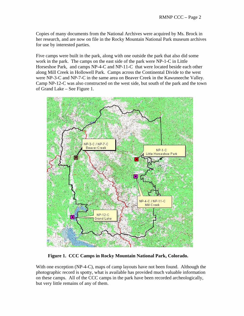
RMNP CCC – Page 2 Copies of many documents from the National Archives were acquired by Ms. Brock in her research, and are now on file in the Rocky Mountain National Park museum archives for use by interested parties. Five camps were built in the park, along with one outside the park that also did some work in the park. The camps on the east side of the park were NP-1-C in Little Horseshoe Park, and camps NP-4-C and NP-11-C that were located beside each other along Mill Creek in Hollowell Park. Camps across the Continental Divide to the west were NP-3-C and NP-7-C in the same area on Beaver Creek in the Kawuneeche Valley. Camp NP-12-C was also constructed on the west side, but south of the park and the town of Grand Lake – See Figure 1.
Figure 1. CCC Camps in Rocky Mountain National Park, Colorado. With one exception (NP-4-C), maps of camp layouts have not been found. Although the photographic record is spotty, what is available has provided much valuable information on these camps. All of the CCC camps in the park have been recorded archeologically, but very little remains of any of them.
RMNP CCC – Page 3 Retired long time west side Park Ranger Bert McLaren said that one of the things the CCC accomplished in the park was to remove many old cabins, associated trash, abandoned mining equipment, and even their own camps. To the detriment of historians and archeologists, the CCC viewed these remains as only unsightly trash as most of the items were only 30 or 40 years old. It is unknown if any fur trader camps or unpatented homestead cabins were removed with the clean up operations as these remains probably looked the same to the uneducated, or under educated, young men working for the CCC. Although there is very little left of their camps, the contributions of the Civilian Conservation Corps to Rocky Mountain National Park is considerable.
A BRIEF INTRODUCTION TO THE CCC
The Civilian Conservation Corps (CCC) was created under the Emergency Conservation Work Act of April 5, 1933. The purpose of the program was to employ young men during the depression. The national parks benefited because federal programs could be enacted quickly
on public lands and because the large road projects then underway in the various parks could make good use of the workers. At Rocky Mountain National Park, both the Civilian Conservation Corps and its affiliated agency, the Emergency Conservation Works (ECW) program, set up work camps and carried out various projects, some of which were related to the road program. The men were housed in camps, provided with clothing, and paid $1 a day, of which $25 per month was sent back to the enrollee's family. Army personnel organized the units and ran the camps, while Park Service personnel dictated the projects and sometimes supervised the work (Quin 1993:51-52).
See Salmond (1957), Lacy (1976), and Paige (1985) for an introduction to the Emergency Conservation Works and CCC programs.
CCC CAMPS
The War Department, i.e., mainly the U.S. Army, was responsible for the selection of men, construction of camps, and the delivery of supplies and equipment. Officers and enrollees quarters were initially army tents that were gradually replaced by more substantial wood structures. Inexpensive prefabricated building components were produced in 1934 which allowed for the efficient construction of several types of buildings. These buildings are very similar in appearance and construction to temporary buildings, i.e., “T-Buildings” designed during World War I and used extensively on military installations throughout the United States during World War II. The standardized design for several kinds of temporary structures were produced as a result of the National Defense Act of 1920 and the Industrial Mobilization Plan in 1931.
RMNP CCC – Page 4
Standardized building plans had been used during World War I, and were called the 600 Series. Over the course of the decade following the war, various other temporary structures had been proposed. Prefabricated wooden buildings that could be broken down quickly and transported were suggested, as well as prefabricated steel structures. Lack of money in the late 1920s and early 1930s hampered development of these building plans; about the same time, scanty funds were allocated to the Construction Division of the Quartermaster Corps for revision of World War I drawings, which evolved into the 700 Series. By 1937 a set of revised drawings had been approved (Wasch and Busch 1989:304). These structures were expected to be serviceable for 20 years (Barnes 1991:11).
Because the CCC was run very much like a military operation, and usually had regular Army personnel in charge, it is reasonable to believe that the CCC building designs also came from the Army. This is suggested by some design elements found in several small houses that were moved from the CCC Camp in Hollowell Park to what is known as the “Ptarmigan Estates” area in the present park Utility Area. The 800 Series building design of the 1940s called for the elimination of the termite shields. The Hollowell Park CCC buildings in the Utility Area have termite shields consisting of canvas impregnated with linseed oil and nailed in a continuous 2 foot high band along the bottom sections of the exterior walls; the shield is covered with simple wood lap siding. The presence of the termite shield in the Ptarmigan Estates buildings that are known to be part of the 1934 – 1940 CCC camp strongly suggests their T-Building origin.
In camps used only in the summer months, pyramidal tents with wood supports were the norm along with a few more substantial buildings such as were used at NP-1-C, NP-3-C, and NP-7-C. Camps intended to be occupied year round, such as NP-4-C, NP-11-C, and NP-12-C, had almost all buildings made of wood, with most being prefabricated after 1936 (Brock 2005b).
A standard camp consisted of about 20 to 30 structures that were usually arranged in a “U” and usually included a recreation hall, garage, equipment maintenance building, hospital, administrative buildings and warehouse, officers quarters, mess hall and kitchen, lavatory and bath house, latrine, blacksmith shop, several barracks, technical service buildings, oil houses, pump house, generator house, and education buildings (Paige 1985). See Table 1 and 2 for a list of buildings at camp NP-1-C and NP-12-C.
The CCC also established temporary work camps known as “side camps” or “stub camps” (aka “spike camps” in NPS parlance) when the projects were located some distance away from the main camps (Paige 1985:70-73). Two stub camps are known for the park. Photographs show one camp that was located at an unknown place and on an unknown date in Wild Basin (RMNP Cat No. 2913, 2914, 3051). Another photograph was taken in August of 1933 for a side camp at the abandoned mining town of Lulu City (RMNP Cat No. 3051). These photographs show several wall tents of various sizes. Other camps undoubtedly existed such as the one that may have been recorded as site 5GA2932 north of camp NP-3-C and near the location of the Phantom Valley Trading Post – see below.
RMNP CCC – Page 5
Little Horseshoe Park Camp NP-1-C Background “The first camp to be established in Rocky Mountain National Park was N.P.C.1 in Little Horseshoe Park on May 13, 1933” (Musselman 1971:96). The camp was also the first camp to be occupied west of the Mississippi River in 1933. The camp contained “… some 24 pyramidal tents for quarters, 4 larger hospital tents, a field kitchen, and other necessary accouterments” (Buchholtz 1983:184). Musselman (1971:101) also notes that “NP-1-C was a temporary camp operated every summer from 1933 until 1938 at Horseshoe Park on the east side of the Divide. There is no mention of this camp in the literature after 1938.” Camp NP-1-C was located on the south side of the glacial moraine separating Little Horseshoe Park from Horseshoe Park to the north (Figures 2 and 3). Photographs and field observations indicate a road extending from the camp to the east to the Cascade Cottages/Aspenglen Campground area near the current park boundary.
Camp One (NP-1-C) was laid out in quasi-military style, with a single company street, flanked by tents perfectly aligned on either side. At the upper end of the street on one side were the administrative office, infirmary, and officer’s mess hall. At the foot of the street were the bathhouse and lavatory, with hot and cold water and showers (Musselman 1971:97).
A National Park Service “Existing Unoccupied Camp Report” of 1941 (?) states that:
This was the first CCC camp occupied west of the Mississippi in 1933. The mess hall, shower and wash room, and generator plant are under permanent roof. Quarters for men, infirmary, office, and supply room consist of platform floors, canvas covered. The roof in the mess hall is usually supported by posts during the winter months. Repairs for recoccupancy usually consist of repairing floors, wall framing, etc.
RMNP CCC – Page 6
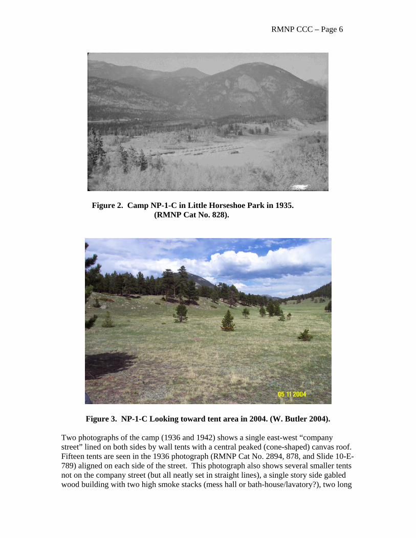
Figure 2. Camp NP-1-C in Little Horseshoe Park in 1935. (RMNP Cat No. 828).
Figure 3. NP-1-C Looking toward tent area in 2004. (W. Butler 2004). Two photographs of the camp (1936 and 1942) shows a single east-west “company street” lined on both sides by wall tents with a central peaked (cone-shaped) canvas roof. Fifteen tents are seen in the 1936 photograph (RMNP Cat No. 2894, 878, and Slide 10-E-789) aligned on each side of the street. This photograph also shows several smaller tents not on the company street (but all neatly set in straight lines), a single story side gabled wood building with two high smoke stacks (mess hall or bath-house/lavatory?), two long
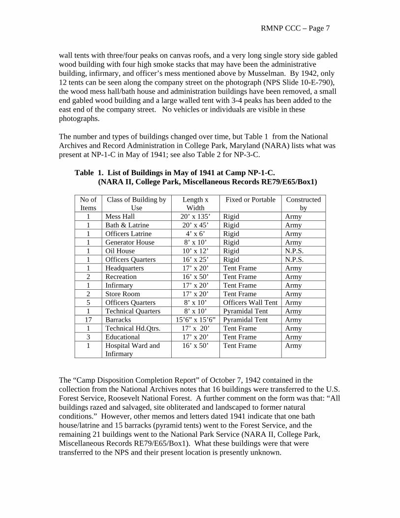
RMNP CCC – Page 7 wall tents with three/four peaks on canvas roofs, and a very long single story side gabled wood building with four high smoke stacks that may have been the administrative building, infirmary, and officer’s mess mentioned above by Musselman. By 1942, only 12 tents can be seen along the company street on the photograph (NPS Slide 10-E-790), the wood mess hall/bath house and administration buildings have been removed, a small end gabled wood building and a large walled tent with 3-4 peaks has been added to the east end of the company street. No vehicles or individuals are visible in these photographs. The number and types of buildings changed over time, but Table 1 from the National Archives and Record Administration in College Park, Maryland (NARA) lists what was present at NP-1-C in May of 1941; see also Table 2 for NP-3-C. Table 1. List of Buildings in May of 1941 at Camp NP-1-C. (NARA II, College Park, Miscellaneous Records RE79/E65/Box1)
No of Items
Class of Building by Use
Length x Width
Fixed or Portable Constructed by
1 Mess Hall 20’ x 135’ Rigid Army 1 Bath & Latrine 20’ x 45’ Rigid Army 1 Officers Latrine 4’ x 6’ Rigid Army 1 Generator House 8’ x 10’ Rigid Army 1 Oil House 10’ x 12’ Rigid N.P.S. 1 Officers Quarters 16’ x 25’ Rigid N.P.S. 1 Headquarters 17’ x 20’ Tent Frame Army 2 Recreation 16’ x 50’ Tent Frame Army 1 Infirmary 17’ x 20’ Tent Frame Army 2 Store Room 17’ x 20’ Tent Frame Army 5 Officers Quarters 8’ x 10’ Officers Wall Tent Army 1 Technical Quarters 8’ x 10’ Pyramidal Tent Army
17 Barracks 15’6” x 15’6” Pyramidal Tent Army 1 Technical Hd.Qtrs. 17’ x 20’ Tent Frame Army 3 Educational 17’ x 20’ Tent Frame Army 1 Hospital Ward and
Infirmary 16’ x 50’ Tent Frame Army
The “Camp Disposition Completion Report” of October 7, 1942 contained in the collection from the National Archives notes that 16 buildings were transferred to the U.S. Forest Service, Roosevelt National Forest. A further comment on the form was that: “All buildings razed and salvaged, site obliterated and landscaped to former natural conditions.” However, other memos and letters dated 1941 indicate that one bath house/latrine and 15 barracks (pyramid tents) went to the Forest Service, and the remaining 21 buildings went to the National Park Service (NARA II, College Park, Miscellaneous Records RE79/E65/Box1). What these buildings were that were transferred to the NPS and their present location is presently unknown.
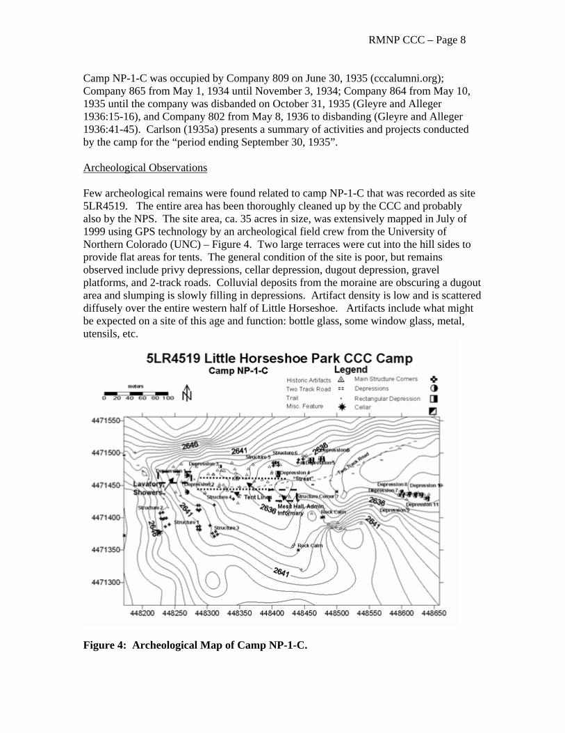
RMNP CCC – Page 8 Camp NP-1-C was occupied by Company 809 on June 30, 1935 (cccalumni.org); Company 865 from May 1, 1934 until November 3, 1934; Company 864 from May 10, 1935 until the company was disbanded on October 31, 1935 (Gleyre and Alleger 1936:15-16), and Company 802 from May 8, 1936 to disbanding (Gleyre and Alleger 1936:41-45). Carlson (1935a) presents a summary of activities and projects conducted by the camp for the “period ending September 30, 1935”. Archeological Observations Few archeological remains were found related to camp NP-1-C that was recorded as site 5LR4519. The entire area has been thoroughly cleaned up by the CCC and probably also by the NPS. The site area, ca. 35 acres in size, was extensively mapped in July of 1999 using GPS technology by an archeological field crew from the University of Northern Colorado (UNC) – Figure 4. Two large terraces were cut into the hill sides to provide flat areas for tents. The general condition of the site is poor, but remains observed include privy depressions, cellar depression, dugout depression, gravel platforms, and 2-track roads. Colluvial deposits from the moraine are obscuring a dugout area and slumping is slowly filling in depressions. Artifact density is low and is scattered diffusely over the entire western half of Little Horseshoe. Artifacts include what might be expected on a site of this age and function: bottle glass, some window glass, metal, utensils, etc.
Figure 4: Archeological Map of Camp NP-1-C.
RMNP CCC – Page 9
Mill Creek ( Hollowell Park) NP-4-C and NP-11-C
Background Camp NP-4-C was established as the park’s first permanent camp on Mill Creek in Hollowell Park in May of 1934. This is the only camp in the park that was occupied throughout the year. The camp was combined with a new permanent camp, NP-11-C, in 1940. Camp NP-4-C was abandoned on June 30, 1941, and NP-11-C became the last camp to serve the park until it was abandoned on July 29, 1942 (Musselman 1971:100-101). See Figures 5 and 6.
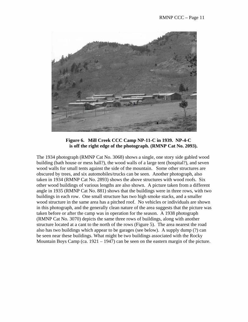
We have been unable to find any maps, photographs, or drawings showing both these camps in the same photo, or on the same map. In fact, maps of any camp are rare, but one for NP-4-C exists in the park’s collection (Figure 7). Photographs (RMNP Cat No. 885 and 2093) taken in November of 1939 shows camp NP-11-C and what may be a building of NP-4-C on the northern edge of NP-11-C, i.e., NP-11-C is immediately south and adjacent to NP-4-C. These are the only known photographs or other documents showing the relationship of these camps to each other. Correspondence in the National Archives (NARA II RE79/65/Box1) include a lengthy, and sometimes acrimonious, back-and-forth discussion between the National Park Service and the Army about the condition of NP-4-C, and whether the camp should be abandoned, salvaged, or repaired when consideration was being given to the construction of a new Camp NP-11-C in the same area. A telegraph from a Mr. Johnston of the War Department dated September 6, 1939, to the Director of the National Park Service, Conrad L. Wirth, seemed to settle the matter:
Inspected Rocky Mountain Park proposed new CCC camps today with Park and Army officials. All in agreement new camp for NP Dash Four is very desirable but not absolutely necessary. Both Army and Park officials feel NP Dash Four can be put in reasonably good condition for long range program by replacing present enrollee barracks latrine and bathhouse with new portable building. All other buildings can be put in good condition with small amount of maintenance. Recommend above be approved and work on remodeling NP Dash Four and construction NP Dash Eleven adjacent be started immediately due to bad whether conditions in about thirty days. Detailed report follows. Johnston. The camp was selected to be a winter camp late in the summer of 1934.
In September, the Army began to construct suitable winter quarters. Company 864 helped with this. The bath house and mess hall which had been built in the spring were altered. A headquarters building, recreation hall, five barracks, latrine, garage and tool house were built (Gleyre and Alleger 1936:45). The waterline and plumbing had to be put in after Company 1812 arrived and the entire 3,800 feet of waterline had to be buried four feet (Gleyre and Alleger 1936:45).
RMNP CCC – Page 10
Company 1812 occupied the new camp for over a year. In that time the grounds were landscaped, walks built, rails and steps put in, and other additions made to make the camp more convenient (Gleyre and Alleger 1936:45).
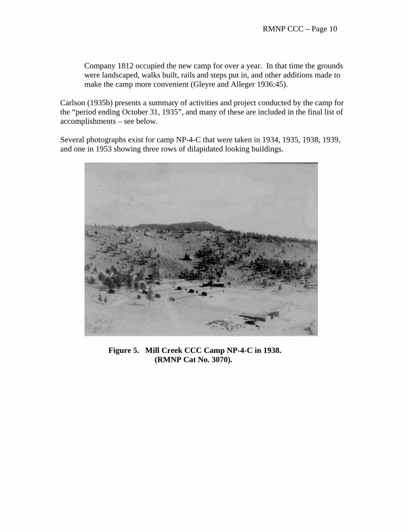
Carlson (1935b) presents a summary of activities and project conducted by the camp for the “period ending October 31, 1935”, and many of these are included in the final list of accomplishments – see below. Several photographs exist for camp NP-4-C that were taken in 1934, 1935, 1938, 1939, and one in 1953 showing three rows of dilapidated looking buildings.
Figure 5. Mill Creek CCC Camp NP-4-C in 1938. (RMNP Cat No. 3070).
RMNP CCC – Page 11
Figure 6. Mill Creek CCC Camp NP-11-C in 1939. NP-4-C is off the right edge of the photograph. (RMNP Cat No. 2093). The 1934 photograph (RMNP Cat No. 3068) shows a single, one story side gabled wood building (bath house or mess hall?), the wood walls of a large tent (hospital?), and seven wood walls for small tents against the side of the mountain. Some other structures are obscured by trees, and six automobiles/trucks can be seen. Another photograph, also taken in 1934 (RMNP Cat No. 2893) shows the above structures with wood roofs. Six other wood buildings of various lengths are also shown. A picture taken from a different angle in 1935 (RMNP Cat No. 881) shows that the buildings were in three rows, with two buildings in each row. One small structure has two high smoke stacks, and a smaller wood structure in the same area has a pitched roof. No vehicles or individuals are shown in this photograph, and the generally clean nature of the area suggests that the picture was taken before or after the camp was in operation for the season. A 1938 photograph (RMNP Cat No. 3070) depicts the same three rows of buildings, along with another structure located at a cant to the north of the rows (Figure 5). The area nearest the road also has two buildings which appear to be garages (see below). A supply dump (?) can be seen near these buildings. What might be two buildings associated with the Rocky Mountain Boys Camp (ca. 1921 – 1947) can be seen on the eastern margin of the picture.
RMNP CCC – Page 12
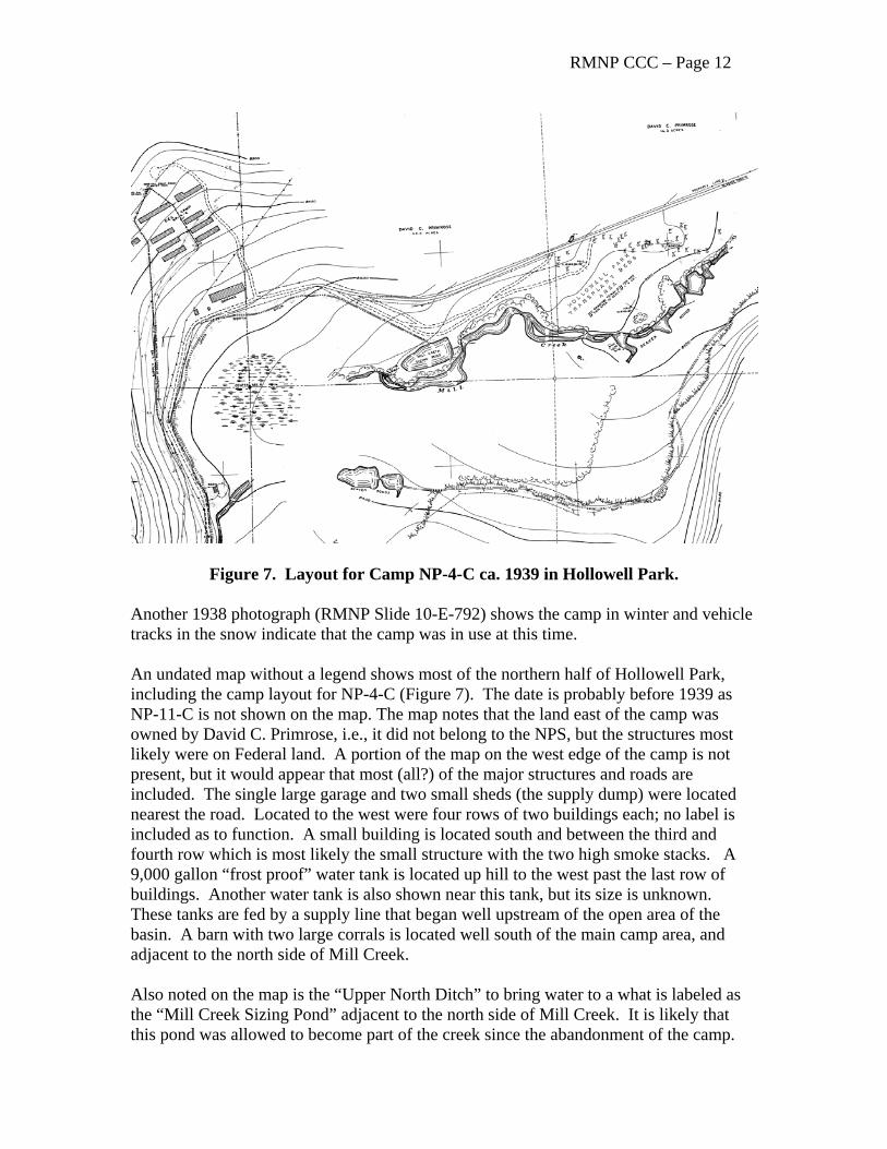
Figure 7. Layout for Camp NP-4-C ca. 1939 in Hollowell Park. Another 1938 photograph (RMNP Slide 10-E-792) shows the camp in winter and vehicle tracks in the snow indicate that the camp was in use at this time. An undated map without a legend shows most of the northern half of Hollowell Park, including the camp layout for NP-4-C (Figure 7). The date is probably before 1939 as NP-11-C is not shown on the map. The map notes that the land east of the camp was owned by David C. Primrose, i.e., it did not belong to the NPS, but the structures most likely were on Federal land. A portion of the map on the west edge of the camp is not present, but it would appear that most (all?) of the major structures and roads are included. The single large garage and two small sheds (the supply dump) were located nearest the road. Located to the west were four rows of two buildings each; no label is included as to function. A small building is located south and between the third and fourth row which is most likely the small structure with the two high smoke stacks. A 9,000 gallon “frost proof” water tank is located up hill to the west past the last row of buildings. Another water tank is also shown near this tank, but its size is unknown. These tanks are fed by a supply line that began well upstream of the open area of the basin. A barn with two large corrals is located well south of the main camp area, and adjacent to the north side of Mill Creek. Also noted on the map is the “Upper North Ditch” to bring water to a what is labeled as the “Mill Creek Sizing Pond” adjacent to the north side of Mill Creek. It is likely that this pond was allowed to become part of the creek since the abandonment of the camp.
RMNP CCC – Page 13 The “South Ditch” is shown carrying water eastward from some beaver ponds. Atkins (1964: Glacier Creek) said that: “Two [fish] rearing ponds were constructed by E.C.W. personnel in Hollowell Park. The “Hollowell Pond” is mentioned in the Superintendent’s Annual Report of 1933 (page 10).” Also north of the creek and further to the east near the location of the Rocky Mountains Boys Camp was the “Hollowell Park Transplant Beds Area” suggesting that one of the CCC programs was revegetation of disturbed areas in the park. Photographs (RMNP Cat No. 885 and 2093) taken in November of 1939 shows camp NP-11-C and what may be a NP-4-C building on the northern edge of NP-11-C (see Figure 5). At this time, NP-11-C consisted of about 15 buildings, with parallel rows of what are probably barracks. This is the same arrangement as NP-4-C which makes it difficult to identify which camp is being shown in the photos. Companies at NP-4-C included 836 on June 15, 1934; 1812 in October 14, 1934; 3884 in October 23, 1936; and 2552 from October 25, 1935 to disbanding on July 29, 1942 (Gleyre and Alleger 1936:17, 45-48; Buchholtz 1983:187). Companies at Camp NP-11-C were 2138 on November 4, 1939, and 2822 on June 30, 1940 (cccalumni.org). A bronze plaque was placed on a large boulder to the northeast of the main NP-4-C camp area. The plaque has been recorded as site 5LR10838. It was placed to honor the first director of the CCC and reads:
IN MEMORIAM
ROBERT E. FECHNER DIRECTOR
CIVILIAN CONSERVATION CORPS 1933 – 1939
CO3884 CO2138 APR. 5, 1940
NP 4 C NP 11 C Archeological Observations The following from Gleyre and Alleger (1936) attest to the numerous land disturbances caused by construction of the camp. This disturbance was further compounded when what was left of the camp was obliterated by the National Park Service in the 1960s.
Construction work began on Camp NP-4-C in April, 1934. The area was graded, a few trees removed and level places prepared for tent frames, bath house, and mess hall. The last two were the only permanent buildings constructed at that time. During the summer of 1934, large hospital tents housed the men, while the officers and officers quarters were in smaller tents (Gleyre and Alleger (1936:45).
RMNP CCC – Page 14 Nothing remains on the surface for camps NP-4-C or NP-11-C. A chance meeting of the University of Northern Colorado field crew with a retired NPS worker in Hollowell Park revealed that anything left on the surface after the CCC had cleaned up the site in preparation for closure was buried by the NPS in giant trenches and covered with dirt. Indeed, sparse vegetation can be found today in an area of high surface disturbance. The eastern edge of Hollowell Park also housed the Rocky Mountain Boy’s Camp (1921 to 1947), and Pedersen (1993:132) said that the camp was used until late in the 1930s when part of the site was reconfigured for the Hollowell Park (aka Mill Creek) CCC Camp, but no information has been found in CCC records to confirm this statement. Retired ranger Ferrell Atkins said that the Park Service once had an “overflow” campground in Hollowell Park in the 1960s. It is thus difficult to sort out what remains belonged to which occupation. Site 5LR4583 was recorded as the actual location for camp NP-11-C, and trash scatter 5LR6973 is thought to be associated with it. Sites 5LR6955 a concrete slab, and 5LR6958 a low rock wall north and east of NP-4-C could be associated with either camp, or even the Boy’s Camp. The location of fish rearing ponds can be seen on the Longs Peak 7.5’ USGS Quadrangle (1961 / rev 1978), but they would be difficult to differentiate from the kinds of beaver or other natural ponds that frequent similar areas in the park without the undated CCC map and the quadrangle map. Many of the small houses along Ptarmigan Drive aka “Ptarmigan Estates” in the park’s Utility Area were moved there from the CCC camp in Hollowell Park in 1946 – 1947. These buildings were modified and are now used for permanent and seasonal employee housing: HS-49, 100, 101, 102, 103, 104, and 105. A construction drawing for HS-100 titled “Alteration of Existing CCC Building (Shop) to Two-Unit Apartment for Unmarried Employees in the Utility Residential Area” is dated May of 1946. Other similar drawings for alterations of CCC structures to residences are available for HS-101 which was originally a bath house, and HS-102 – garage, HS-103 – reading room, and HS-104 and HS-105 that were also garages. The drawings for these buildings are also dated to May of 1946.
Beaver Creek in Kawuneeche Valley NP-3-C and NP-7-C Background Camps NP-3-C and NP-7-C were located in the western side of the park along Beaver Creek in the Kawuneeche Valley (Figures 8 and 9).
Another camp was established on June 23 [1933] near Phantom Valley [Ranch], thirteen miles from Grand Lake, and its recruits worked until transferred to State Park number one in Arizona on October 15, 1933 (Musselman 1971:99).
RMNP CCC – Page 15
NP-3-C was a temporary camp operated during the summers of 1933 and 1934 at Phantom Valley, west of the [Continental] Divide. In the summer of 1935, NP-3-C was replaced by NP-7-C, another temporary camp which was disbanded during the spring of 1936. NP-7-C was re-occupied in the summer of 1938. It was eventually replaced by a permanent camp, NP-12-C, established near Grand Lake in the summer of 1940. NP-12-C was one of the last two camps to serve the Park, being abandoned in the summer of 1942 (Musselman 1971:101).
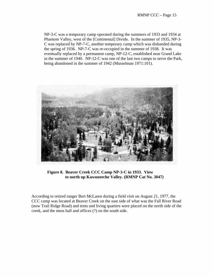
Figure 8. Beaver Creek CCC Camp NP-3-C in 1933. View to north up Kawuneeche Valley. (RMNP Cat No. 3047) According to retired ranger Bert McLaren during a field visit on August 21, 1977, the CCC camp was located at Beaver Creek on the east side of what was the Fall River Road (now Trail Ridge Road) and tents and living quarters were placed on the north side of the creek, and the mess hall and offices (?) on the south side.
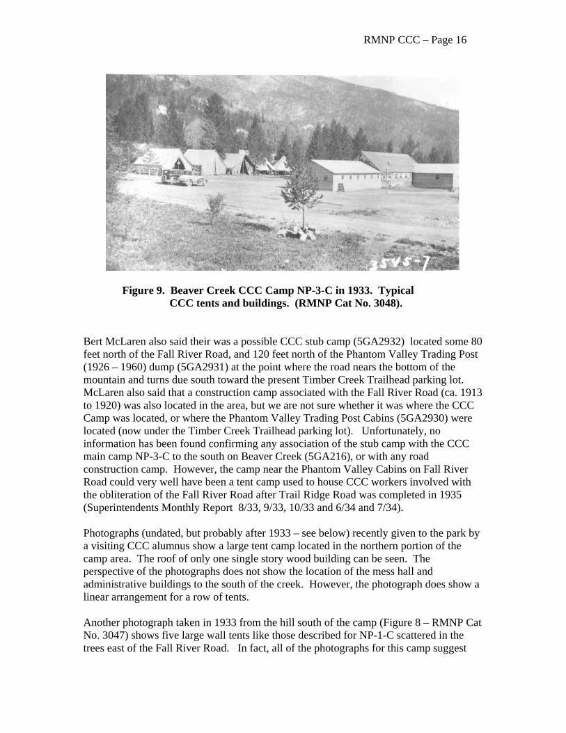
RMNP CCC – Page 16
Figure 9. Beaver Creek CCC Camp NP-3-C in 1933. Typical CCC tents and buildings. (RMNP Cat No. 3048). Bert McLaren also said their was a possible CCC stub camp (5GA2932) located some 80 feet north of the Fall River Road, and 120 feet north of the Phantom Valley Trading Post (1926 – 1960) dump (5GA2931) at the point where the road nears the bottom of the mountain and turns due south toward the present Timber Creek Trailhead parking lot. McLaren also said that a construction camp associated with the Fall River Road (ca. 1913 to 1920) was also located in the area, but we are not sure whether it was where the CCC Camp was located, or where the Phantom Valley Trading Post Cabins (5GA2930) were located (now under the Timber Creek Trailhead parking lot). Unfortunately, no information has been found confirming any association of the stub camp with the CCC main camp NP-3-C to the south on Beaver Creek (5GA216), or with any road construction camp. However, the camp near the Phantom Valley Cabins on Fall River Road could very well have been a tent camp used to house CCC workers involved with the obliteration of the Fall River Road after Trail Ridge Road was completed in 1935 (Superintendents Monthly Report 8/33, 9/33, 10/33 and 6/34 and 7/34). Photographs (undated, but probably after 1933 – see below) recently given to the park by a visiting CCC alumnus show a large tent camp located in the northern portion of the camp area. The roof of only one single story wood building can be seen. The perspective of the photographs does not show the location of the mess hall and administrative buildings to the south of the creek. However, the photograph does show a linear arrangement for a row of tents. Another photograph taken in 1933 from the hill south of the camp (Figure 8 – RMNP Cat No. 3047) shows five large wall tents like those described for NP-1-C scattered in the trees east of the Fall River Road. In fact, all of the photographs for this camp suggest
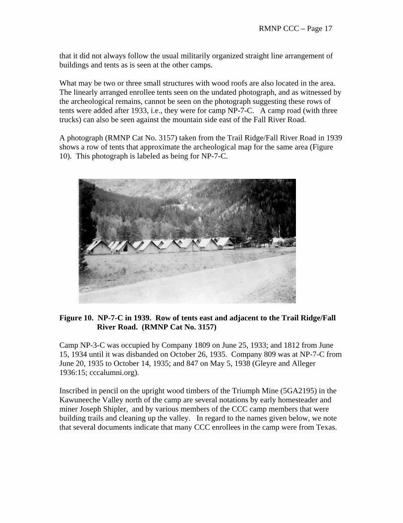
RMNP CCC – Page 17 that it did not always follow the usual militarily organized straight line arrangement of buildings and tents as is seen at the other camps. What may be two or three small structures with wood roofs are also located in the area. The linearly arranged enrollee tents seen on the undated photograph, and as witnessed by the archeological remains, cannot be seen on the photograph suggesting these rows of tents were added after 1933, i.e., they were for camp NP-7-C. A camp road (with three trucks) can also be seen against the mountain side east of the Fall River Road. A photograph (RMNP Cat No. 3157) taken from the Trail Ridge/Fall River Road in 1939 shows a row of tents that approximate the archeological map for the same area (Figure 10). This photograph is labeled as being for NP-7-C.
Figure 10. NP-7-C in 1939. Row of tents east and adjacent to the Trail Ridge/Fall River Road. (RMNP Cat No. 3157) Camp NP-3-C was occupied by Company 1809 on June 25, 1933; and 1812 from June 15, 1934 until it was disbanded on October 26, 1935. Company 809 was at NP-7-C from June 20, 1935 to October 14, 1935; and 847 on May 5, 1938 (Gleyre and Alleger 1936:15; cccalumni.org). Inscribed in pencil on the upright wood timbers of the Triumph Mine (5GA2195) in the Kawuneeche Valley north of the camp are several notations by early homesteader and miner Joseph Shipler, and by various members of the CCC camp members that were building trails and cleaning up the valley. In regard to the names given below, we note that several documents indicate that many CCC enrollees in the camp were from Texas.
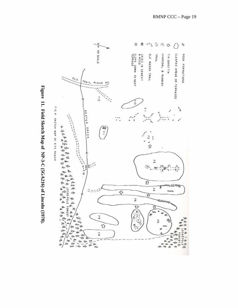
RMNP CCC – Page 18 “J.E. Shipler August 11, 1897” “Harry E. Buchman, Honey Grove, Tx” “Norwin” “CCC Colorado 1809 Grand Lake, Colorado July 29, 1933” “John Rogers, Dkalt, Texas Sept 14, 1933” “CCC 1809 GL Co” “Write me any time please” Archeological Observations Camp NP-3-C (5GA216) was first archeologically recorded by Thomas Lincoln of the Midwest Archeological Center of the National Park Service in 1978. However, he believed that he was recording the location of Squeaky Bob Wheeler’s Hotel de Hardscrabble, which was actually located about a half a mile to the north on the Colorado River. Although he was mistaken in his identification, the description and associated map (Lincoln 1978:10-14 – see Figure 11) closely parallels the findings and map produced during the University of Northern Colorado survey (Brunswig 2001). Archeological remains observed by the UNC crew in 2000 consist of a low linear mound of rock and dirt about 20 feet long which may have severed as an e-w foundation for one side of a structure, a depression 20 feet long at right angles (n-s) may represent the location of another foundation wall. As the photographs indicate that tents were mostly used in the camp, the foundation may have been for a more permanent cooking/eating facility. Also recorded in the UNC survey were several other rock walls and foundations, rock cairns, shoes, Prince Albert tobacco cans, milled lumber, metal fragments, bricks, wire, buttons, metal pipes and leather fragments. Although both surveys identified several areas with archeological remains, the Lincoln map (Figure 11) provides more useful information in that it was drawn almost 30 years ago when features were much more distinct. Noted on the Lincoln map were several rock lines/walls which are suggested here to coincide with pathways to tents as seen on the undated photographs recently given to the park by a CCC alumnus who was an enrollee at the camp. We note that lining a path with rocks and/or placing rocks in front of buildings or tent as if they were a fence between a structure and the adjacent street or path is a typical U.S. military practice. The rocks were usually painted white in permanent Army and Marine installations.
RMNP CCC – Page 19
Figure 11. Field Sketch Map of N
P-3-C (5G
A216) of L
incoln (1978).
RMNP CCC – Page 20
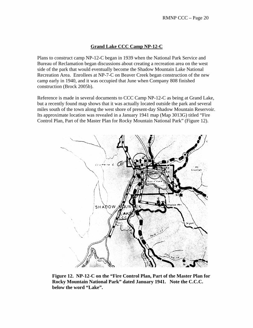
Grand Lake CCC Camp NP-12-C Plans to construct camp NP-12-C began in 1939 when the National Park Service and Bureau of Reclamation began discussions about creating a recreation area on the west side of the park that would eventually become the Shadow Mountain Lake National Recreation Area. Enrollees at NP-7-C on Beaver Creek began construction of the new camp early in 1940, and it was occupied that June when Company 808 finished construction (Brock 2005b). Reference is made in several documents to CCC Camp NP-12-C as being at Grand Lake, but a recently found map shows that it was actually located outside the park and several miles south of the town along the west shore of present-day Shadow Mountain Reservoir. Its approximate location was revealed in a January 1941 map (Map 3013G) titled “Fire Control Plan, Part of the Master Plan for Rocky Mountain National Park” (Figure 12).
Figure 12. NP-12-C on the “Fire Control Plan, Part of the Master Plan for Rocky Mountain National Park” dated January 1941. Note the C.C.C. below the word “Lake”.
RMNP CCC – Page 21 The map is little better than a large scale sketch map, but it suggests that the camp was located just north of where the Colorado River enters the reservoir from the west. The camp was not part of the Colorado-Big Thompson Project (C-BT) work camp which was located south of the river, as historian Christine Pfaff of the Bureau of Reclamation said that the Bureau had no record of the CCC camp being located in what is now known as the C-BT Shadow Mountain Village area (Pfaff p.c. 2001). No photographs of this camp have been found. The C-BT Shadow Mountain work camp was constructed between 1937 and 1946 by the Bureau of Reclamation. Also known as the Shadow Mountain Village Colorado-Big Thompson Camp, it is now the Arapaho National Forest Recreation Area Work Camp (5GA1893). According to Pfaff (1998), the Shadow Mountain dams, dikes, Grand Lake – Shadow Mountain Lake connecting channel, and Granby Pump Canal were all constructed between 1944 and 1946 as part of the C-BT. Some information about the CCC camp is provided by a newspaper article (possibly the Denver Post dated June 15, 1940 – on file, Denver Public Library, Western History Collection):
A permanent CCC camp to be established near Grand Lake on the bank of the Colorado River will be ready for occupancy about June 30. It will operate summer and winter, replacing a temporary summer camp ten miles north [NP-3-C/NP-7-C]. It will cooperate with the Reclamation Bureau workers in clearing of Shadow Mt. and Granby reservoir sites.
The importance of its [the CCC] work was evident when in 1940 a permanent camp replaced the temporary one at Grand Lake. The Park Service operated this camp on a cooperative basis with the United States Reclamation Bureau. It houses about 150 young men, the majority of them seventeen and eighteen years old. Most of them came from Oklahoma, though there were a few from Texas and northeastern Colorado. The principal project of the camp was to clear timber from the basins of the proposed Shadow Mountain and Granby reservoirs (Musselman 1917:107).
A later article in the Denver Post of July 6, 1940 said that 300 CCC boys arrived from Oklahoma at “their new camp three miles south of the village [Grand Lake] on grounds between the river and highway”. The statement “grounds between the river and highway” would suggest a location about one quarter mile north of the Bureau of Reclamation C-BT work camp; the statement is consistent with the location shown on the 1941 map.
RMNP CCC – Page 22 A newspaper article (Denver Post ?) dated July 26, 1941 said:
A few miles south of Grand Lake on highway 34, a sign points to a C.C.C. camp a few hundred feet off the road where is located the several large frame buildings and equipment. Approximately 150 boys, most of them 17 and 18 years old, are stationed at the Grand Lake camp, altho at present 50 of them are at the side camp at Morrison where they are completing the huge Red Rocks amphitheater. However, the principal project of the Grand Lake camp is clearing timber from the basis of the proposed Shadow Mountain and Granby reservoirs. The boys fell the timber in the winter, and cut it up in the sawmill near the camp and clean up the ground in summer. The lumber will be used in the Park – none will be sold.
Like the other camps in the park, very little is known about camp NP-12-C or its layout except for a few references and a list of buildings and equipment included on a 1942 “Shipping Ticket” from the War Department to the District Engineer, Kansas City, Missouri (Table 12.2). No correspondence has been found indicating that the 27 buildings on the list were actually “shipped” and the “Shipping Ticket” was more likely used as a document indicating a change in responsibility for the buildings. However, all of the buildings are described as “Frame, portable” which suggests they could be easily moved. Where the buildings actually went is unknown, but the C-BT Shadow Mountain work camp just to the south is a likely candidate. Indeed, the buildings at the C-BT work camp are of the same T-Building design as used by the CCC. The National Park Service obtained at least one building as indicated on a War Department Shipping Ticket dated September 7, 1942, and a letter dated February 3, 1943 that transferred a 30 x 31 foot portable maintenance shop to the Service. The present location of this building is unknown.
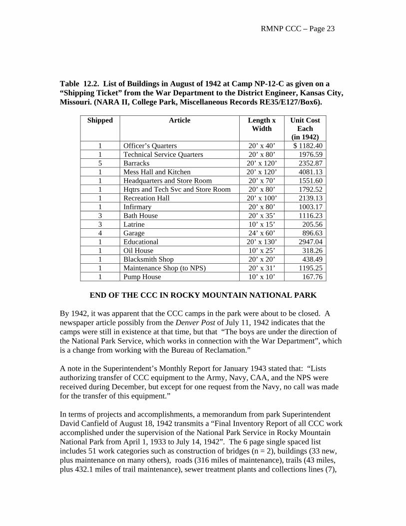
RMNP CCC – Page 23 Table 12.2. List of Buildings in August of 1942 at Camp NP-12-C as given on a “Shipping Ticket” from the War Department to the District Engineer, Kansas City, Missouri. (NARA II, College Park, Miscellaneous Records RE35/E127/Box6).
Shipped Article Length x Width
Unit Cost Each
(in 1942) 1 Officer’s Quarters 20’ x 40’ $ 1182.40 1 Technical Service Quarters 20’ x 80’ 1976.59 5 Barracks 20’ x 120’ 2352.87 1 Mess Hall and Kitchen 20’ x 120’ 4081.13 1 Headquarters and Store Room 20’ x 70’ 1551.60 1 Hqtrs and Tech Svc and Store Room 20’ x 80’ 1792.52 1 Recreation Hall 20’ x 100’ 2139.13 1 Infirmary 20’ x 80’ 1003.17 3 Bath House 20’ x 35’ 1116.23 3 Latrine 10’ x 15’ 205.56 4 Garage 24’ x 60’ 896.63 1 Educational 20’ x 130’ 2947.04 1 Oil House 10’ x 25’ 318.26 1 Blacksmith Shop 20’ x 20’ 438.49 1 Maintenance Shop (to NPS) 20’ x 31’ 1195.25 1 Pump House 10’ x 10’ 167.76
END OF THE CCC IN ROCKY MOUNTAIN NATIONAL PARK
By 1942, it was apparent that the CCC camps in the park were about to be closed. A newspaper article possibly from the Denver Post of July 11, 1942 indicates that the camps were still in existence at that time, but that “The boys are under the direction of the National Park Service, which works in connection with the War Department”, which is a change from working with the Bureau of Reclamation.” A note in the Superintendent’s Monthly Report for January 1943 stated that: “Lists authorizing transfer of CCC equipment to the Army, Navy, CAA, and the NPS were received during December, but except for one request from the Navy, no call was made for the transfer of this equipment.” In terms of projects and accomplishments, a memorandum from park Superintendent David Canfield of August 18, 1942 transmits a “Final Inventory Report of all CCC work accomplished under the supervision of the National Park Service in Rocky Mountain National Park from April 1, 1933 to July 14, 1942”. The 6 page single spaced list includes 51 work categories such as construction of bridges (n = 2), buildings (33 new, plus maintenance on many others), roads (316 miles of maintenance), trails (43 miles, plus 432.1 miles of trail maintenance), sewer treatment plants and collections lines (7),
RMNP CCC – Page 24 utility lines (465 miles), water lines (8 miles), amphitheaters (3), landscaping, reservoirs, fish ponds, rock walls, and many other tasks. The CCC also fought seven forest fires, and assisted in several search and rescue operations. Although the focus of his research was on the roads in the park, Richard Quin also noted that:
Although the workers concentrated on erosion and insect control and improvement of park utilities, they did some work related to the park roads, including landscaping of the Fall River Entrance, obliteration of old roads, slope betterment and maintenance of several park routes. They also carried on the program of roadside cleanup, especially in the removal of dead and down timber and undergrowth along road corridors. In 1935, ECW crews assisted park crews with road maintenance work, including grading, clearing of culverts and gutters, and roadside cleanup. Superintendent Rogers noted that the work was helpful on account of limited funds available to the park maintenance division. ECW crews constructed seven new checking stations on the park roads in 1937. They also prepared 264 new "rustic" directional signs to replace unsightly metal ones then in use. Units also assisted in snow removal and graveled the Moraine Park Museum parking area (Quin 1993:52).
The CCC played an important part in the development of Rocky Mountain National Park, and a commemorative plaque has been placed beside a wayside exhibit at an overlook on the road above Little Horseshoe Park and the location of Camp NP-1-C. REFERENCES CITED Atkins, D. Ferrel 1964 Historic Sites and Buildings Survey, Historic Structures Catalog, Volumes I
and II. Unpublished manuscript on file Rocky Mountain National Park. Also many files and historical notes collected by Atkins at Rocky Mountain National Park
Barnes, Andrea M. 1991 An Archival and Photographic Study of World War II Temporary Wooden
Buildings, Fort Carson Military Reservation, Colorado. Report on file National Park Service, Intermountain Support Office Denver, and U.S. Army, Fort Carson, Colorado.
Brunswig, Robert H., Jr. 2001a Report on 2000 Archaeological Surveys in Rocky Mountain National Park by
the University of Northern Colorado. Report on file Rocky Mountain National Park and Midwest Archeological Center, Lincoln.
RMNP CCC – Page 25 Brock, Julia 2005a Creating Consumers: The Civilian Conservation Corps in Rocky Mountain
National Park Unpublished M.A. Thesis, Department of History, Florida State University, Tallahassee, Florida
2005b A History of the Civilian Conservation Corps in Rocky Mountain National
Park. Report on file Rocky Mountain National Park. Buchholtz, Curt W. 1983 Rocky Mountain National Park: A History. Colorado Associated University
Press, Boulder. Butler, William B. 2005 The Historic Archeology of Rocky Mountain National Park. Report on file
Rocky Mountain National Park. Carlson, George A. 1935a Rocky Mountain National Park Narrative Report, Period Ending September
30, 1935, Camp NP-4-C,. Report on file Rocky Mountain National Park. 1935b Rocky Mountain National Park Narrative Report, Period Ending October 31,
1935, Camp NP-1-C. Report on file Rocky Mountain National Park. Gleyre, L. A. and C. N. Alleger (compilers) 1936 History of the Civilian Conservation Corps in Colorado: Littleton District-
Grand Junction District, Summer 1936 Press of the Western Newspaper Union, Denver. Publication date approximate.
Lacy, Leslie Alexander. 1976 The Soil Soldiers: The Civilian Conservation Corps in the Great
Depression. Chilton Book Company, Radnor, Pennsylvania. Lincoln, Thomas R. 1978 Archeological Reconnaissance, Rocky Mountain National Park, 1978.
Report on file Rocky Mountain National Park and Midwest Archeological Center, Lincoln, NE.
Musselman, Lloyd K. 1971 Rocky Mountain National Park Administrative History, 1915-1965. Report
on file Rocky Mountain National Park. Paige, John C. 1985 The Civilian Conservation Corps and the National Park Service, 1933-1942:
An Administrative History. National Park Service, Department of the Interior.
RMNP CCC – Page 26 Parham, Robert Bruce 1981 The Civilian Conservation Corps in Colorado, 1933-1942. Unpublished
M.A. Thesis, Department of History, University of Colorado, Boulder. Pedersen, Henry F., Jr. 1993 Those Castles of Wood: The Story of Early Lodges of Rocky Mountain
National Park and Pioneer Days of Estes Park Colorado. Privately published, Estes Park, Colorado.
Pfaff, Christine 1998 The Colorado-Big Thompson Project: Historic Context and Description of
Property Types. Bureau of Reclamation, Denver..
Quin, Richard H. 1993 Rocky Mountain National Park Roads. Historic American Engineering
Record No. CO-78.; Fall River Road No. CO-73; Trail Ridge Road CO-31. National Park Service, Washington, D.C.
Salmond, John 1967 The Civilian Conservation Corps, 1933-1942: A New Deal Case Study.
Duke University Press, Durham.
Wasch, Diane, and Perry Busch 1989 World War II Temporary Buildings: The U.S. Army. Draft manuscript
edited by John Burns. Historic American Building Survey/Historic American Engineering Record. National Park Service, Washington, D.C.
William B. Butler, Ph.D. Park Archeologist Rocky Mountain National Park 1000 Highway 36 Estes Park, Colorado 80517