Embed Size (px)
Citation preview
The assessment of transport impacts on land use:practical uses in strategic planning
B.G. Still* , A.D. May, A.L. Bristow
Institute for Transport Studies, University of Leeds, Leeds, UK
Abstract
This article, focusing upon the UK, examines the relevance to strategic planning of methods to estimate the impacts of transport policy onland use processes. The study applied three differing techniques for forecasting these impacts to a common study area, and assessed planners’views on each. The methods comprised a Delphi survey, a simple static land use model, and a linked land-use/transport model. It was foundthat many factors influenced planners’ views on appropriate methods. In general, comprehensive-modelling methods could provide a toolsuitable for the needs of planners, but only if the underpinnings of the model were clear.q 1999 Elsevier Science Ltd. All rights reserved.
Keywords:Delphi survey; Land-use/transport models; Planning methods
1. Introduction
Within the UK at present there is considerable interestamong planners in integrating land use and transport plan-ning, primarily to assist in reducing car based travel, andhence obtaining sustainable development patterns. As aresult, the examination of land use and transport interactionhas focused almost entirely on how land use patterns affecttravel demand, and which urban forms are most energyefficient (e.g. Department of the Environment and Depart-ment of Transport, 1993; Hall, 1997; Coombe andSimmonds, 1997).
The converse, i.e. how transport in turn affects urbandevelopment, has received only cursory interest, and isonly briefly mentioned in the UK Government’s current(but due to be revised) advice on land use and transportplanning, Planning Policy Guidance 13 (Department ofthe Environment and Department of Transport, 1994), orin the recent White Paper (Department of Environment,Transport and Regions, 1998). Yet there are strong reasonsto support the view that these impacts should be studied;from the clear long term link between transport technologyand urban form (Hall, 1989; Giannopoulos and Curdes,1992), through micro level studies regarding complex trans-port influences on development, to theoretical argumentsregarding urban dynamics over time (e.g. Hunt andSimmonds, 1993; Mackett, 1995). It is the methods to assess
how transport can influence land-use which are the focus ofthis paper.
There is no history within the UK planning of consistentlyexamining the impact of transport on land use. Previousresearch (Still, 1996), has found that these impacts remainedexternal to the mainstream planning practice because:
• there is no requirement in policy to examine suchimpacts;
• there is a perception that unplanned developmentimpacts resulting from transport can be controlled viathe development planning process;
• there is a belief that the circumstances under whichdevelopment can be directly attributed to transportchanges are vague and difficult to predict;
• there is a widespread unfamiliarity with the methods toforecast impacts.
Comparative research in the USA has found that, incontrast to the UK, there is overt recognition of the impor-tance of transport impacts on land use patterns, and hence onpatterns of travel demand (Still, 1996). There are legislativerequirements to examine these impacts for US urban areasfailing to meet air quality regulations. Planners must show(through forecasting) that their transport policies will notworsen air quality through any mechanism, including landuse response.
However, in common with the UK, in the USA there isstill a debate over the most appropriate method to examinethese impacts. This research therefore assesses the relativemerits of different methods for the practical examination oftransport impacts on land use. A wholly analytical
Transport Policy 6 (1999) 83–98PERGAMON
0967-070X/99/$ - see front matterq 1999 Elsevier Science Ltd. All rights reserved.PII: S0967-070X(99)00010-4
www.elsevier.com/locate/tranpol
* Corresponding author. Tel.:1 113-233-5355; fax:1 113-233-5325.E-mail address:[email protected] (B.G. Still)
assessment of the range of methods would be difficult toachieve. Instead the criteria for assessment is based uponexperience in using a variety of methods to consider a set ofcommon policy tests in a common study area, and practisingplanners’ own assessments of the methods and the results.
This paper begins by describing three methods selectedfrom the range of possible techniques. An assessment ismade of the methods based upon the criteria of (1) thevalidity of the method, and (2) the plausibility of the result-ing forecasts. The remainder of the paper then focuses uponplanners’ reactions to the methods and the results. The plan-ners were asked to make an assessment against a similar setof criteria, namely their views on: (1) the relevance of theoutputs; (2) the validity of the methods; (3) the plausibilityof the forecasts; and (4) the overall importance of the meth-ods to strategic planning practice. Conclusions are drawnfrom these findings concerning the criteria necessary for amethod to satisfy the planners’ requirements.
2. The range of potential methods to examine transportimpacts on land use
Table 1 outlines the possible methods for determining theimpacts of transport on land use. The methods outlined inTable 1 are all ‘operational’ in that they have been usedeither in the UK or elsewhere to inform planning policy.Methods (1) planners’ judgement and (2) informal use ofexperts’ opinion, were identified from interview basedresearch (Still, 1996) as the most commonly used in theUK. The Delphi method (3) is common in the USA,where a rapid method has often been required initially tomeet the air quality legislative requirements. Simple quan-tified assessment frameworks (4) have been applied for
several transport proposals (e.g. Halcrow Fox and Associ-ates, 1996; WS Atkins Planning Consultants and ECOTEC,1990), and generally tend to examine employment anddevelopment impacts only. Where these frameworks havea fuller theoretical economic underpinning (such as byOscar Faber TPA, ERM and Cambridge Systematics,1994), they have been classified as economic frameworks(6). Simple land use allocation models (5) can examinepopulation and employment impacts, and again are commonin USA (for example the use of DRAM/EMPAL; Putman,1994), and have also been used in Sweden (Anderstig andMattsson, 1992). Finally, land-use/transport models (7) arearguably the most comprehensive methods that can beapplied, of which the ‘Martin Centre models’ have hadthe most applications (e.g. Williams, 1994).
To cover the spectrum of formal approaches, the illustra-tive methods applied in this research focused upon oneexample from each of (3), (5) and (7). Methods (1) and(2) were considered too informal, given that the planners’views would be sought in appraisal of the other methods.Method (4) is open to more subjective judgement than themodelling methods, and was not considered sufficientlyrigorous compared to method (5). Method (6) would ideallyhave been applied, but information on the assumptionswithin known frameworks were not available in sufficientdetail to enable them to be developed within the resources ofthe study.
3. Application of three methods to the case study area
3.1. The case study area and the policies tested
Edinburgh was selected as the study area for this researchfor a number of reasons. Firstly it, and the wider Lothianregion, are expanding in terms of economic growth andpopulation, and are of sufficient size to warrant strategicplanning. Edinburgh, in common with many other UKcities, is facing decentralisation pressures among certainhousehold types and employment sectors. It is also a cityof high architectural and cultural value, yet one in whichincreasing traffic congestion is threatening to reduce itsenvironmental quality.
Edinburgh has also been innovative in terms of its trans-port policy. The former Lothian Region was one of the firstin UK to adopt an ‘integrated urban transport strategy’ (Mayet al., 1992), and the City Council is actively consideringboth light rapid transit (LRT) and road pricing, as potentialelements in its plans to curb pollution and congestion withinthe city. The region has a number of transport models rele-vant to strategic planning. This includes a version of MVA’s‘Strategic and Regional Transport Model’ (START; initiallydiscussed in Bates et al., 1991), which was made availablefor this research.
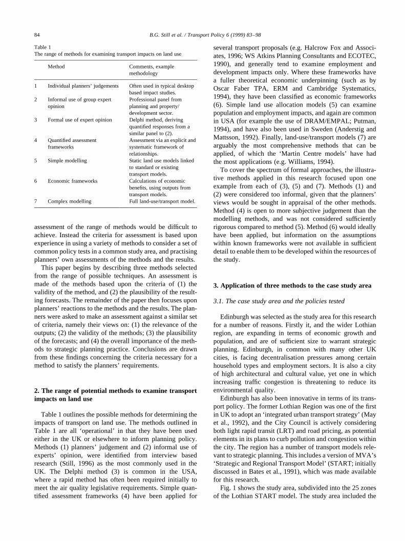
Fig. 1 shows the study area, subdivided into the 25 zonesof the Lothian START model. The study area included the
B.G. Still et al. / Transport Policy 6 (1999) 83–9884
Table 1The range of methods for examining transport impacts on land use
Method Comments, examplemethodology
1 Individual planners’ judgements Often used in typical desktopbased impact studies.
2 Informal use of group expertopinion
Professional panel fromplanning and property/development sector.
3 Formal use of expert opinion Delphi method, derivingquantified responses from asimilar panel to (2).
4 Quantified assessmentframeworks
Assessment via an explicit andsystematic framework ofrelationships.
5 Simple modelling Static land use models linkedto standard or existingtransport models.
6 Economic frameworks Calculations of economicbenefits, using outputs fromtransport models.
7 Complex modelling Full land-use/transport model.
districts from the former Lothian Region, as well assouthern Fife (Dunfermline and Kirkcaldy). Fig. 1 alsoshows how these zones were grouped together for the ninezone aggregation used in the Delphi survey (the aggregationin which, for simplicity, the results in this paper arepresented).
Each of the three methods was implemented for twopolicy tests, which were based upon elements of thebest performing strategies in the Lothian integratedtransport strategy, as outlined in May et al. (1992).The first was a road pricing cordon around the citycentre (zones 1, 2 and 12 in Fig. 1). A charge of£1.50 (1991 prices) was applied for traffic passingeach way through the cordon, operating all day. Thesecond was a light rail (LRT) system, with two linesoperating with a 5 min headway, each passing throughthe city centre (Waverley Station). The ‘East–West’line ran from the airport (zone 16) to Leith (zone 4),the ‘North–South’ line ran from zone 3 down to the‘South–East wedge’ (zone 5), an area earmarked formajor housing and commercial development. LRTfares were assumed to be set equal to bus fares.Each policy was compared with a ‘do-minimum’,which assumed no additional transport infrastructure,and fares, prices and frequencies following historictrends.
3.2. Method 1: formal expert opinion-the Delphi method
The Delphi method aims to obtain quantified opinions
from a sample of experts in a subject area, in a systematicand non-biased manner using repeated questionnaires. Eachpanellist remains anonymous to the others, hence reducingthe risk of ‘interpersonal static’ and individual bias. Panel-lists can adjust their responses to the questions, oncepresented with the results from the previous round. Thisprocess aims to obtain a consensus on the direction andmagnitude of the impacts within the panel.
The use of experts in this way has been investigated andjustified by Amara and Lipinski (1972). Experts providemore than merely a sensible guess to the results, as theybring to bear an in-depth understanding of relationshipsleading to results. Hence Amara and Lipinski argue thatsuch forecasts, even from small samples of experts (aslow as 8–12), are more likely to be realistic than from largersamples of ‘lay persons’.
The Delphi method has not been applied widely in trans-portation studies, and is most commonly used in assessingthe impact of new transport technologies. In assessing trans-port impacts on land use it has been applied in the UnitedStates (Cavalli-Sforza and Ortolano, 1984), and also toforecast the impact of the Sheffield Supertram (Antwi andHennebury, 1995). However, it has also been used at theearly stages of strategic plan formulation (e.g. Smyth,1995), and hence is not unknown amongst practisingplanners.
In these cases the Delphi offered a relatively cheap(compared to most model development projects) andpractical means of obtaining opinions on likely impacts,using experts in the subject area, without the expense of
B.G. Still et al. / Transport Policy 6 (1999) 83–98 85
Fig. 1. Study area with START and Delphi zones.
developing a mathematical model. However, as a tool inplanning it is limited because it cannot be used to test theimpacts of strategies other than those considered in thequestionnaire. Further, the sample must be carefullyselected (and ideally multidisciplinary) to encompass a vari-ety of perspectives and minimise strategic bias. There is alsoa limit to the length of the questionnaire that can be success-fully applied without respondent fatigue.
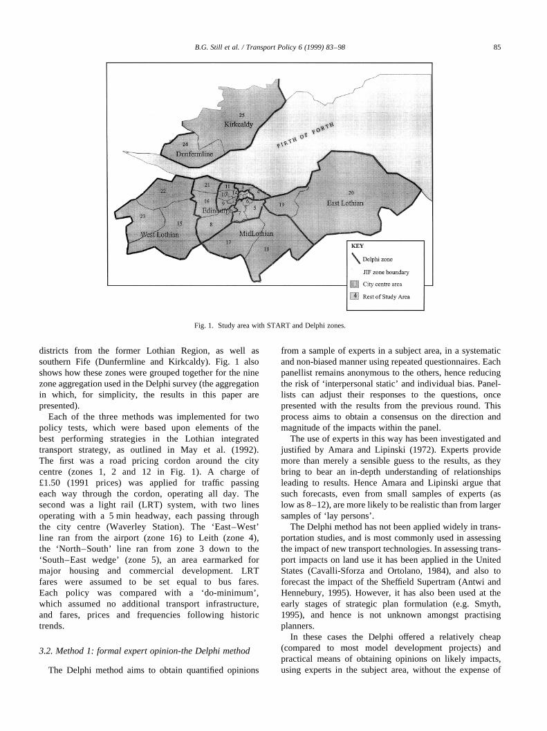
The panel approached in this research consisted of prop-erty experts from the study area (property agents, surveyorsand developers), planners from the local authorities, andplanning consultants. It was considered that these groupswould complement each other (e.g. planners being strongeron the demographics, the property experts stronger on theprice indicators, but both with some knowledge of the otherindicator). The sample completing the entire Delphiconsisted of 18 members, a typical and sufficient numberfor a Delphi exercise (Amara and Lipinski, 1972). Table 2gives the specialisms listed by each panel member.
The Delphi developed for Lothian was more ambitiousthan the previous ‘transport impact’ Delphi studies refer-enced above in terms of the spatial disaggregation, butconsidered fewer indicators as a result of this. The indicatorsselected were retail and office rents, and population distri-bution. Rents were selected due to their role as intermediaryvariables in market processes, and as indicators of demandchanges. Population was selected as an example of planningdata used in strategic planning. The 25 zones shown in Fig.1 were aggregated to nine zones for the Delphi, as it was
clear during piloting that forecasting for 25 zones was tooarduous for a respondent to consider. The implications ofthis zoning difference are highlighted below.
The aims of the questionnaire were to obtain responsesregarding the expected trends in population distribution,office and retail rents over the next 15 years in each zone(i.e. a do-minimum forecast); and then the scale and timingof any changes (expressed as percentage changes from thedo-minimum forecast year) due to the LRT strategy and theroad pricing strategy.
In addition, respondents were encouraged to give reasonsfor their predictions, and space was given on the question-naire for this (although responses were often limited). Twoquestionnaire rounds were undertaken over a period of sixmonths. The general results showed a reduction in the stan-dard deviation of the responses in the second round,suggesting that a better consensus was being obtained.However, resources did not permit more than two roundsof questionnaires to be undertaken.
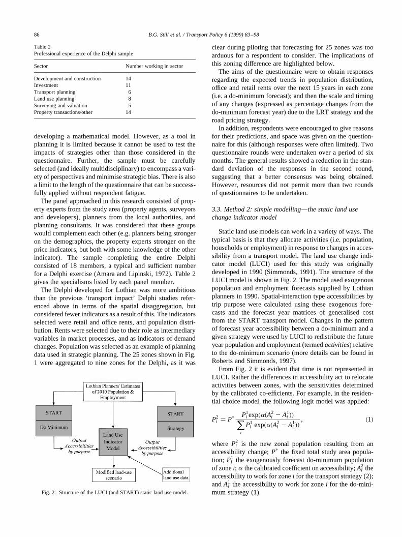
3.3. Method 2: simple modelling—the static land usechange indicator model
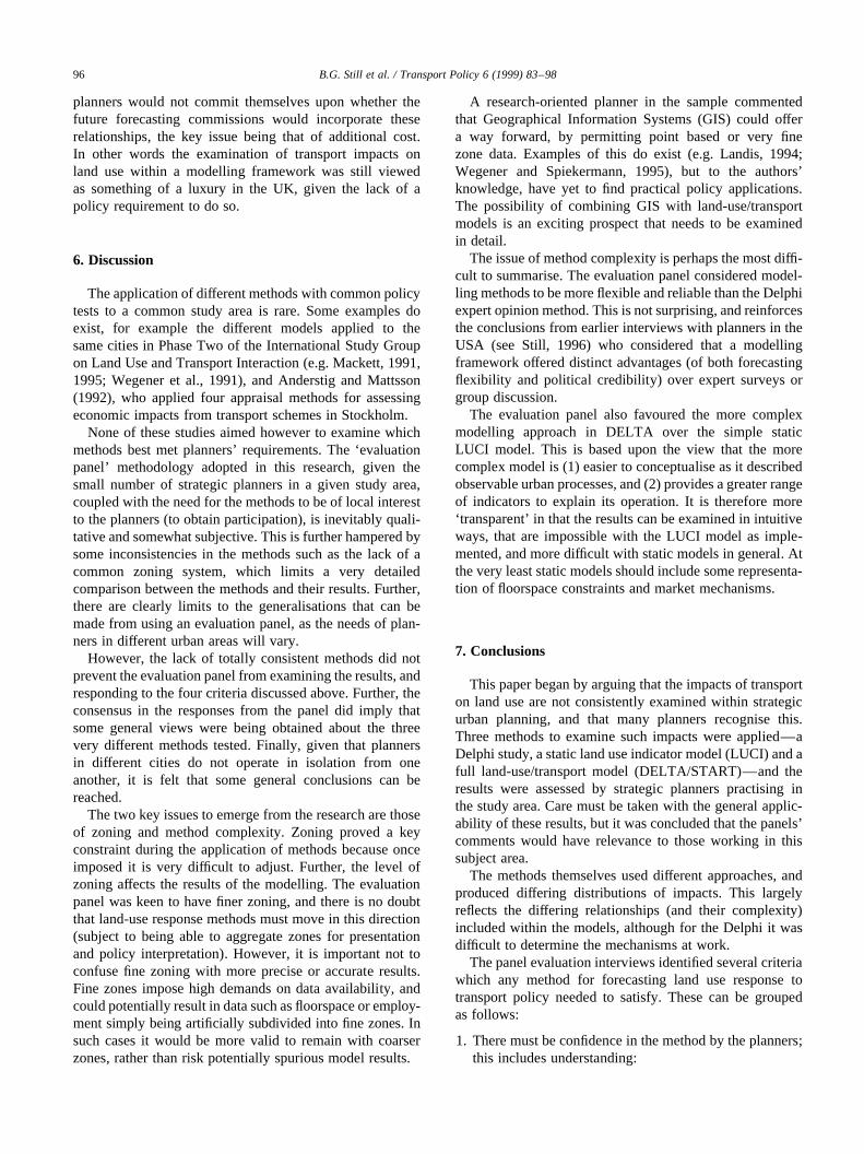
Static land use models can work in a variety of ways. Thetypical basis is that they allocate activities (i.e. population,households or employment) in response to changes in acces-sibility from a transport model. The land use change indi-cator model (LUCI) used for this study was originallydeveloped in 1990 (Simmonds, 1991). The structure of theLUCI model is shown in Fig. 2. The model used exogenouspopulation and employment forecasts supplied by Lothianplanners in 1990. Spatial-interaction type accessibilities bytrip purpose were calculated using these exogenous fore-casts and the forecast year matrices of generalised costfrom the START transport model. Changes in the patternof forecast year accessibility between a do-minimum and agiven strategy were used by LUCI to redistribute the futureyear population and employment (termedactivities) relativeto the do-minimum scenario (more details can be found inRoberts and Simmonds, 1997).
From Fig. 2 it is evident that time is not represented inLUCI. Rather the differences in accessibility act to relocateactivities between zones, with the sensitivities determinedby the calibrated co-efficients. For example, in the residen-tial choice model, the following logit model was applied:
P2i � Pp P1
i exp�a�A2i 2 A1
i ��Xi
P1i exp�a�A2
i 2 A1i ��
; �1�
where P2i is the new zonal population resulting from an
accessibility change;Pp the fixed total study area popula-tion; P1
i the exogenously forecast do-minimum populationof zonei; a the calibrated coefficient on accessibility;A2
i theaccessibility to work for zonei for the transport strategy (2);andA1
i the accessibility to work for zonei for the do-mini-mum strategy (1).
B.G. Still et al. / Transport Policy 6 (1999) 83–9886
Table 2Professional experience of the Delphi sample
Sector Number working in sector
Development and construction 14Investment 11Transport planning 6Land use planning 8Surveying and valuation 5Property transactions/other 14
Fig. 2. Structure of the LUCI (and START) static land use model.
Retail and non-retail service employment were repre-sented in a similar way (non-service employment wasassumed not to be sensitive to accessibility changes),although a multiplicative function was found to allowthe best calibration. Constraining the study area totals,the resultant incremental model for retail employmentwas:
E2i � Ep E1
i �A2i =A
1i �aX
i
E1i �A2
i =A1i �a
; �2�
where E2i is the modified zonal employment in zonei;
E1i the do-minimum retail employment in zonei; Ep the
fixed study area total retail employment;A2i the acces-
sibility (to residents) by zone for the transport strategy;A1
i the accessibility (to residents) for the do-minimumstrategy; and,a the coefficient on accessibility.
Other than changing accessibility, all other variables inthe urban system that could influence location choice wereassumed constant (although some static models can repre-sent floorspace supply and market clearing mechanisms).LUCI, as implemented neither included any of these feed-back relationships nor any constraints concerning theamount of land or floorspace available in each zone. Forthese reasons the model outputs are termedindicatorsratherthan forecasts, as they are both simple and abstractmeasures.
The model, not being iterative, could be run very quicklyonce set up, and required minimal additional resourcesbeyond the transport model. The LUCI model had beenpreviously calibrated using cross sectional data (Simmonds,1991), and used the zoning system shown in Fig. 1.However, it did not extend into Fife; zones 24 and 25(unfortunately to implement the model for these zoneswas beyond the resources of this study).
3.4. Method 3: the land-use/transport model: DELTA/START
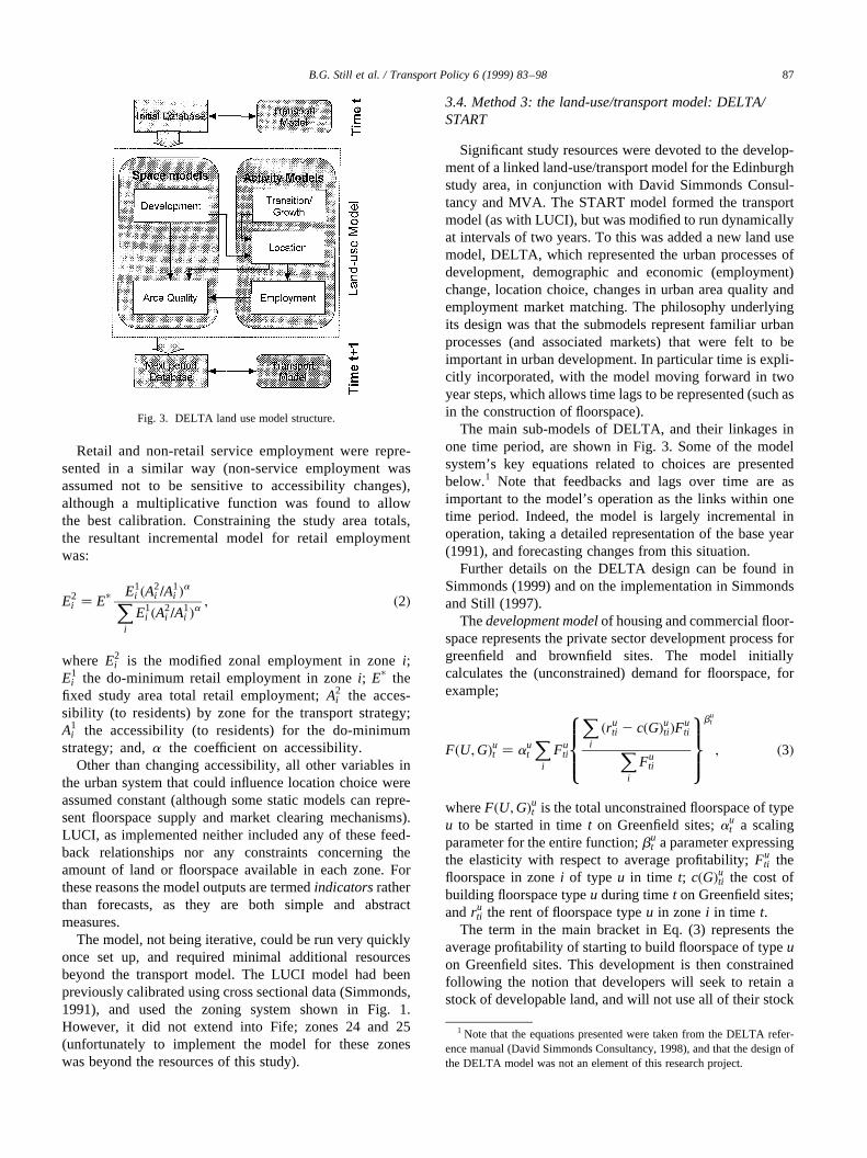
Significant study resources were devoted to the develop-ment of a linked land-use/transport model for the Edinburghstudy area, in conjunction with David Simmonds Consul-tancy and MVA. The START model formed the transportmodel (as with LUCI), but was modified to run dynamicallyat intervals of two years. To this was added a new land usemodel, DELTA, which represented the urban processes ofdevelopment, demographic and economic (employment)change, location choice, changes in urban area quality andemployment market matching. The philosophy underlyingits design was that the submodels represent familiar urbanprocesses (and associated markets) that were felt to beimportant in urban development. In particular time is expli-citly incorporated, with the model moving forward in twoyear steps, which allows time lags to be represented (such asin the construction of floorspace).
The main sub-models of DELTA, and their linkages inone time period, are shown in Fig. 3. Some of the modelsystem’s key equations related to choices are presentedbelow.1 Note that feedbacks and lags over time are asimportant to the model’s operation as the links within onetime period. Indeed, the model is largely incremental inoperation, taking a detailed representation of the base year(1991), and forecasting changes from this situation.
Further details on the DELTA design can be found inSimmonds (1999) and on the implementation in Simmondsand Still (1997).
Thedevelopment modelof housing and commercial floor-space represents the private sector development process forgreenfield and brownfield sites. The model initiallycalculates the (unconstrained) demand for floorspace, forexample;
F�U;G�ut � aut
Xi
Futi
Xi
�ruti 2 c�G�uti�Fu
tiXi
Futi
8>><>>:9>>=>>;
but
; �3�
whereF�U;G�ut is the total unconstrained floorspace of typeu to be started in timet on Greenfield sites;au
t a scalingparameter for the entire function;bu
t a parameter expressingthe elasticity with respect to average profitability;Fu
ti thefloorspace in zonei of type u in time t; c�G�uti the cost ofbuilding floorspace typeu during timet on Greenfield sites;andru
ti the rent of floorspace typeu in zonei in time t.The term in the main bracket in Eq. (3) represents the
average profitability of starting to build floorspace of typeuon Greenfield sites. This development is then constrainedfollowing the notion that developers will seek to retain astock of developable land, and will not use all of their stock
B.G. Still et al. / Transport Policy 6 (1999) 83–98 87
Fig. 3. DELTA land use model structure.
1 Note that the equations presented were taken from the DELTA refer-ence manual (David Simmonds Consultancy, 1998), and that the design ofthe DELTA model was not an element of this research project.
within one period (how much they develop will dependupon the size ofF�U;G�ut relative to the total availablestock). Development is then allocated to zones on thebasis of zonal expected profitability using a weighted logitformula.
Demographic changeis represented via a Markov-chaintype ‘transition’ model of probabilities that households ofone type will transform into other types (e.g. by theprocesses of childbirth, children leaving home, migration,divorce, death, etc.). The transition rates were calculatedfrom the British National Household Panel Survey (Bucket al., 1994). In and out migration was taken from previousCensus estimates, and study areaemployment growthbysector from local authority Structure Plan forecasts.
The location choice modelfor employment and house-holds takes into account several factors influencing locationchoice, namely utility of consumption, accessibility, areaquality and transport related environmental quality. Theutility of consumption for each household is calculatedusing a Cobb–Douglas function based upon two goods;space demanded, and all other goods and services (OGS).Households are assumed to adjust the mixture of OGS andspace until they maximise their utility of consumption. Foreach household type the change in the utility of location isthen calculated as:
DVhti � uhU�Uh
ti 2 Uh�t2n�i�1 uhA�Ah
ti 2 Ah�t2n�i�
1 uhQ�Qhti 2 Qh
�t2n�i�1 uhR�Rhti 2 Rh
�t2n�i�; �4�
whereDVhti is the change in total utility to be gained in a
zone for a given household type;Uhti the utility of consump-
tion for householdsh locating in zonei at time t; Ahti the
accessibility of zonei for household typeh at timet; Qhti the
quality of housing in zonei at timet; Rhti the transport related
environmental quality as perceived by householdsh in zonei at timet, and;u are parameters on each term which deter-mine the relative sensitivity of households between acces-sibility, the environment, quality and utility of consumption,and also the overall sensitivity of households to each factor.
Note that more complex accessibility measures were usedby DELTA, being specific to each activity type. The (t 2 n)subscripts show that the change in the variable can be fromthe previous time period, or from several time periods ago.This change in utilityDVh
ti is then used in an incrementallogit model location function to locate households for thatgiven year, expressed as:
Hhti � Hh
tp :Hh
ti :�F�V�hti =Fhti� exp�DVh
ti �Xi
Hhti :�F�V�hti =Fh
ti� exp�DVhti �
; �5�
whereHhti are households of typeh choosing zonei in time t.
Hhtp are the total number of households to be locatedHh
ti arethe households of typeh living in zonei at current timet Fh
ti
is the total residential floorspace for at this timeF�V�hti is the
available floorspace in the zoneDVhti is the change in utility
of location as in Eq. (2).The location model iterates, adjusting rents until all the
‘mobile households’ are located. Note that most householdsremain ‘immobile’, i.e. not changing location or entering theproperty market in any one time period. Employment activ-ities use a similar, but simpler form of Eq. (4), with theutility of consumption for households replaced by cost mini-mising behaviour, and the environmental variablesexcluded.
Once activities are located in zones, the demand foremployment must be met by the available workers in thestudy area. Anemployment matching submodelthus adjuststhe number of workers in households until the supplymatches the demand. Note that the system is modelled asa single labour market, i.e. the location of a household rela-tive to a job has no bearing on the likelihood of a workerobtaining that job.
Finally, thearea quality modelrepresents changes in thequality of the urban fabric as a linear lagged function of theaverage income of the residents living there.
The DELTA model is designed so that the individualsubmodels are calibrated individually, and follows theideas used in the various implementations of START(Roberts and Simmonds, 1997) of using pre-existing para-meters for model sensitivities, from a variety of sources.The parameters in thedevelopment modelwere estimatedfrom changes in available floorspace data over time,although the tight planning controls in Edinburgh meantthat development tended to occur as and when land becameavailable. The co-efficients for thetransition modelhavealready been outlined. Existing cross sectional calibratedco-efficients from elsewhere in the UK were used for thelocation model(later enhancements to the parameters fromstated preference research are reported in Wardman et al.,1997).
3.5. Initial assessment of the validity of the methods
How valid is each of these methods for assessing trans-port impacts on land use? The three methods representdifferent places on the spectrum of forecasting methodsthat are available for spatial planning (from Table 1), andit is useful to highlight the central differences in theirapproaches.
The distinction between the Delphi and the more formalmodelling approaches is straightforward. The Delphiapproach does not use a mathematical model, or any explicitaccessibility measure. Instead it relies upon the judgementof its panel. As such, while the models are deductive inapproach, the Delphi is inductive; making use of the mentalmodels of the panel members.
The key difference between the LUCI/START andDELTA/START modelling approaches is that the formeruses exogenous planners’ forecasts, while the latter gener-ates its own unique forecast. DELTA represents the effects
B.G. Still et al. / Transport Policy 6 (1999) 83–9888
of several influences on location choice considered by themodel developer to be important (such as floorspaceconstraints, environmental conditions, rents and demo-graphic change), while LUCI only represents accessibility.LUCI uses accessibility by travel purpose only, whileDELTA calculates an accessibility for each activitysumming over relevant travel purposes. Finally, DELTAfollows a behavioural and process based approach (incor-porating supply side constraints), while LUCI takes a muchsimpler, but less intuitive structure, with no supply sideconstraints.
Several factors serve to limit the validity of eachapproach as applied here. The Delphi cannot offer a clearor unified explanation for its forecasts, and can give only aselection of indicators with limited spatial disaggregation,given the demands this places on the panel. The LUCImethod holds many variables constant, has no processbased structure, and is very dependent upon the quality ofthe local area calibration. DELTA is very complex, andimplementing the model is a significant undertaking. Italso places higher demands on the linked transport model.It too requires some local calibration, but places greaterreliance on the notion of ‘adaptable co-efficients’ fromother research.
As a result, there is little doubt that, from a research
perspective, the ‘theory rich’ DELTA approach, incorporat-ing the main land-use–transport interactions consideredimportant for examining impacts, and producing a widerange of indicators, is preferred to the simple but less robustLUCI approach. The Delphi method is much more of acomplement than a substitute, being an entirely independentsource of forecasts, but is severely limited by the amount ofdata that can reasonably be obtained.
4. Comparison of the results from the three methods
4.1. Introductory comments: comparison of the do-minimumsituations and policy tests
All reasonable efforts were made to ensure that the start-ing situations of the methods were comparable in terms ofthe starting year data, zoning and do-minimum forecasts,although differing model requirements meant that theycould not be identical.
In terms of data for the starting year (1991), for theDelphi, initial base year population and rent estimates byzone were not supplied to the panel. An option to supplythese was rejected due to the additional data burden that thiswould have placed on the respondents. The Delphi therefore
B.G. Still et al. / Transport Policy 6 (1999) 83–98 89
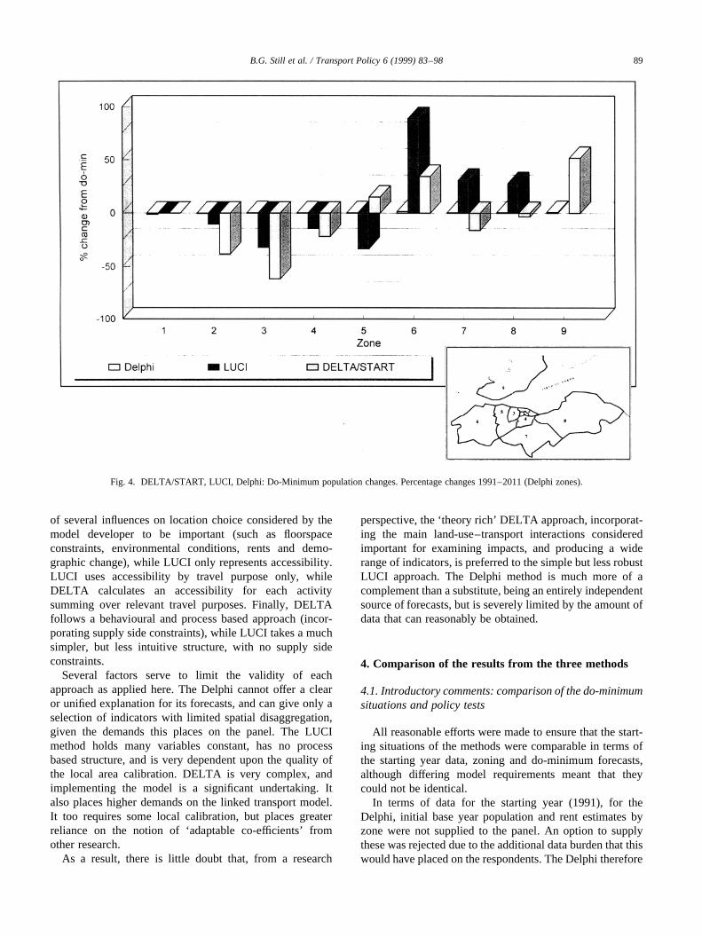
Fig. 4. DELTA/START, LUCI, Delphi: Do-Minimum population changes. Percentage changes 1991–2011 (Delphi zones).
relies upon the panel having an understanding of the currentsituation in the study area.
More important were differences in the zoning.There are two issues here, firstly the more aggregatezoning used in the Delphi, and secondly the inclusionof Fife in the DELTA model. The implications ofdifferent zoning systems were discussed in depth withthe planners (see below). However, at this point it isclear that (1) the Delphi technique is limited in spatialresolution due to the demands this would place on thepanel to estimate a large number of impacts, and (2)within the DELTA/START system, activities have theoption to locate in Fife, which they do not in LUCI/START. This means that the same policy applied in bothsystems would be expected to give slightly differing loca-tional impacts.
There were some differences in the implementation of thedo-minimum strategies (and hence in the results, see below).In DELTA, as outlined above, floorspace allocations wereobtained from the structure plan, and then the modeldecided whether they were developed and occupied. In theLUCI model, these steps are determined by the plannersthemselves in producing the original exogenous populationand employment forecasts.
These differences in the base assumptions do of course
make systematic comparisons between the methods moredifficult. Certainly some of the inconsistencies could havebeen overcome if further resources had been available, forexample, to implement the LUCI model for the Fife zones.Nevertheless, as the key comparisons were to be made onthe differences between the respective do-minima and thepolicy tests, it was felt that informative comparisons couldstill be made.
4.2. The do-minimum
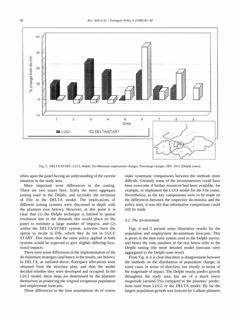
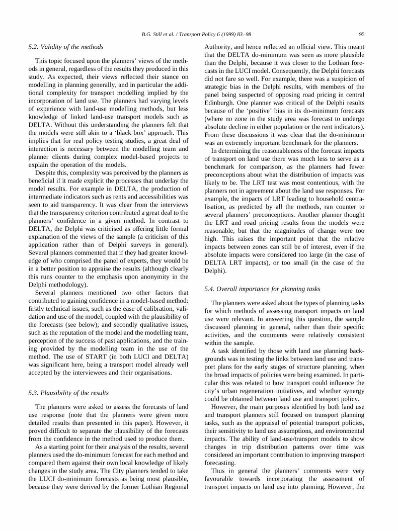
Figs. 4 and 5 present some illustrative results for thepopulation and employment do-minimum forecasts. Thisis given in the nine-zone system used in the Delphi survey,and hence the zone numbers in the text below refer to theDelphi zoning (the more detailed model forecasts wereaggregated to the Delphi zone level).
From Fig. 4, it is clear that there is disagreement betweenthe methods on the distribution of population change, insome cases in terms of direction, but mostly in terms ofthe magnitude of impact. The Delphi results predict growththroughout the study area, but are of a much lowermagnitude (around 5%) compared to the planners’ predic-tions used from LUCI, or the DELTA model. By far thelargest population growth was forecast by Lothian planners
B.G. Still et al. / Transport Policy 6 (1999) 83–9890
Fig. 5. DELTA/START, LUCI, Delphi: Do-Minimum employment changes. Percentage changes 1991–2011 (Delphi zones).
for West Lothian (Delphi zone 6), which is also the zone ofabsolute highest growth for DELTA.
The DELTA model and the planners providing the LUCIforecasts also gave estimates on the distribution of employ-ment growth (Fig. 5). While the Lothian planners (LUCIestimates) predicted further growth in the centre, theDELTA model estimates greater decentralisation ofemployment. This can be traced to the availability offloorspace in the outer areas, coupled with lowercommercial rents than in the city centre or the rest ofEdinburgh. Both LUCI and DELTA estimate employ-ment growth in the Gyle edge of town commercialcentre (Delphi zone 3), although for DELTA at theSTART zone level there are declines in surroundingzones, giving a net fall in the larger Delphi zone. This is agood example of how the changes in zoning can influencethe interpretation of results.
In short, the do-minimum forecasts appeared different,but each represented a degree of net decentralisation overthe forecast period. Further, the differences, especiallybetween the DELTA and LUCI models, were explainable.One area of concern remains why the Delphi forecasts ofchange in distribution were low for all indicators (andconstant across zones) compared to the models. The modelswere clearly more sensitive to likely future supply condi-tions than were the judgements of the Delphi panel.
4.3. The impacts from the transport tests on population
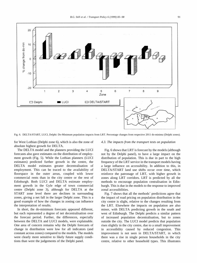
Fig. 6 shows that LRT is forecast by the models (althoughnot by the Delphi panel), to have a large impact on thedistribution of population. This is due in part to the highfrequency of the LRT service in the transport models havinga large influence on accessibility. In addition to this, inDELTA/START land use shifts occur over time, whichreinforce the patronage of LRT, with higher growth inzones along LRT corridors. LRT is predicted by all themethods to encourage population centralisation in Edin-burgh. This is due in the models to the response to improvedzonal accessibilities.
Fig. 7 shows that all the methods’ predictions agree thatthe impact of road pricing on population distribution in thecity centre is slight, relative to the changes resulting fromthe LRT. Elsewhere the impacts on population are alsominor, with DELTA predicting growth in the south andwest of Edinburgh. The Delphi predicts a similar patternof increased population decentralisation, but to zonesoutside the city. The LUCI model predicts that populationrises slightly in the city centre, due to a small improvementin accessibility caused by reduced congestion. Thisimprovement is not seen in DELTA/START, in whichthere was a rise in single person households in the citycentre, relative to other household types. This illustrates
B.G. Still et al. / Transport Policy 6 (1999) 83–98 91
Fig. 6. DELTA/START, LUCI, Delphi: Do-Minimum population impacts from LRT. Percentage changes from respective 2011 do-minima (Delphi zones).
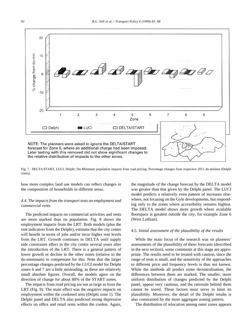
how more complex land use models can reflect changes inthe composition of households in different areas.
4.4. The impacts from the transport tests on employment andcommercial rents
The predicted impacts on commercial activities and rentsare more marked than on population. Fig. 8 shows theemployment impacts from the LRT. Both models (plus therent indicators from the Delphi), estimate that the city centrewill benefit in terms of jobs and/or incur higher rent levelsfrom the LRT. Growth continues in DELTA until supplyside constraints affect in the city centre several years afterthe introduction of the LRT. There is a general pattern oflower growth or decline in the other zones (relative to thedo-minimum) to compensate for this. Note that the largerpercentage changes predicted by the LUCI model for Delphizones 6 and 7 are a little misleading, as these are relativelysmall absolute figures. Overall, the models agree on thedirection of change for about 80% of the START zones.
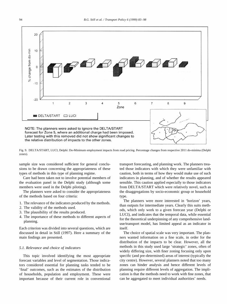
The impacts from road pricing are not as large as from theLRT (Fig. 9). The main effect was the negative impacts onemployment within the cordoned area (Delphi zone 1). TheDelphi panel and DELTA also predicted strong depressiveeffects on office and retail rents within the cordon. Again,
the magnitude of the change forecast by the DELTA modelwas greater than that given by the Delphi panel. The LUCImodel predicts a relatively even pattern of increases else-where, not focusing on the Gyle developments, but respond-ing only to the zones where accessibility remains highest.The DELTA model shows more growth where availablefloorspace is greatest outside the city, for example Zone 6(West Lothian).
4.5. Initial assessment of the plausibility of the results
While the main focus of the research was on planners’assessments of the plausibility of these forecasts (describedin the next section), some comments at this stage are appro-priate. The results need to be treated with caution, since therange of tests is small, and the sensitivity of the approachesto different price and frequency levels is thus not known.While the methods all predict some decentralisation, thedifferences between them are marked. The smaller, moreuniform distribution of changes predicted by the Delphipanel, appear very cautious, and the rationale behind themcannot be tested. These factors must serve to limit itsplausibility. Moreover, the detail of the Delphi results isalso constrained by the more aggregate zoning pattern.
The distribution of relocation among outer zones appears
B.G. Still et al. / Transport Policy 6 (1999) 83–9892
Fig. 7. DELTA/START, LUCI, Delphi: Do-Minimum population impacts from road pricing. Percentage changes from respective 2011 do-minima (Delphizones).
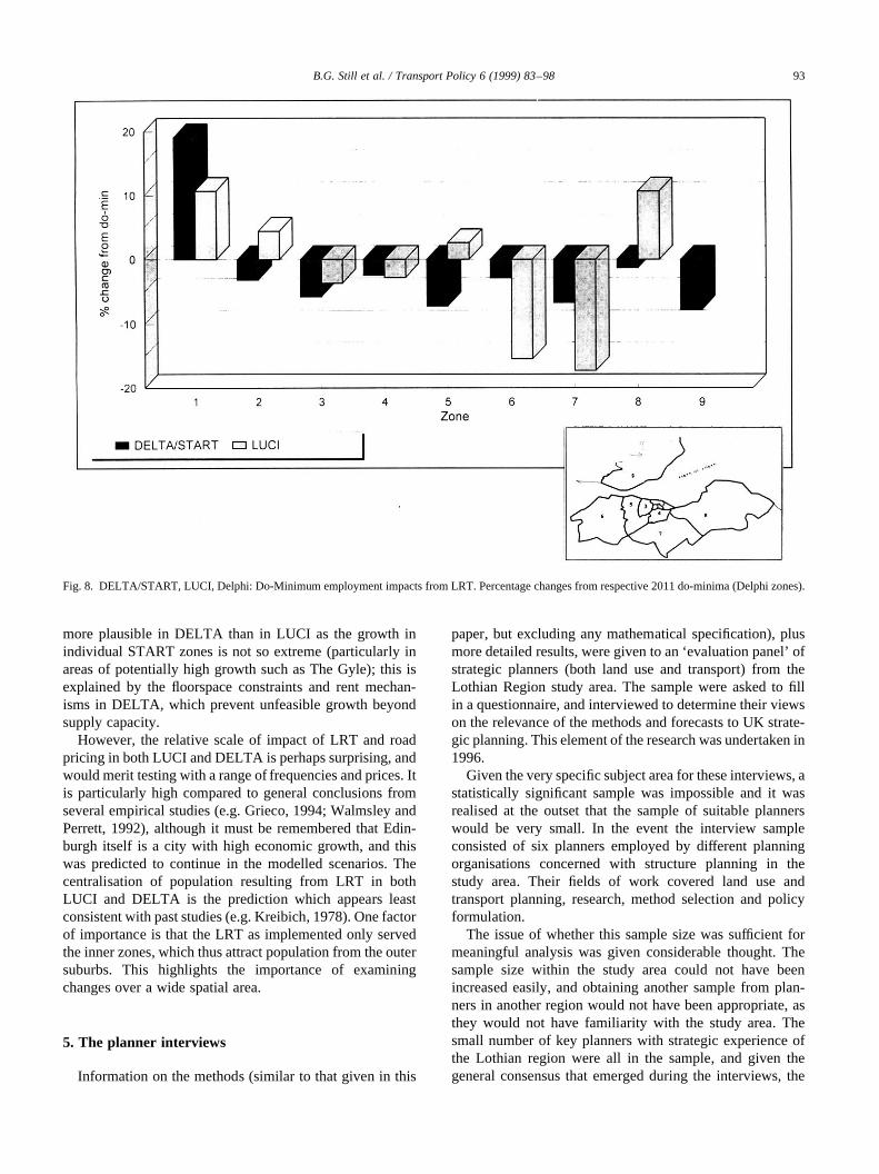
more plausible in DELTA than in LUCI as the growth inindividual START zones is not so extreme (particularly inareas of potentially high growth such as The Gyle); this isexplained by the floorspace constraints and rent mechan-isms in DELTA, which prevent unfeasible growth beyondsupply capacity.
However, the relative scale of impact of LRT and roadpricing in both LUCI and DELTA is perhaps surprising, andwould merit testing with a range of frequencies and prices. Itis particularly high compared to general conclusions fromseveral empirical studies (e.g. Grieco, 1994; Walmsley andPerrett, 1992), although it must be remembered that Edin-burgh itself is a city with high economic growth, and thiswas predicted to continue in the modelled scenarios. Thecentralisation of population resulting from LRT in bothLUCI and DELTA is the prediction which appears leastconsistent with past studies (e.g. Kreibich, 1978). One factorof importance is that the LRT as implemented only servedthe inner zones, which thus attract population from the outersuburbs. This highlights the importance of examiningchanges over a wide spatial area.
5. The planner interviews
Information on the methods (similar to that given in this
paper, but excluding any mathematical specification), plusmore detailed results, were given to an ‘evaluation panel’ ofstrategic planners (both land use and transport) from theLothian Region study area. The sample were asked to fillin a questionnaire, and interviewed to determine their viewson the relevance of the methods and forecasts to UK strate-gic planning. This element of the research was undertaken in1996.
Given the very specific subject area for these interviews, astatistically significant sample was impossible and it wasrealised at the outset that the sample of suitable plannerswould be very small. In the event the interview sampleconsisted of six planners employed by different planningorganisations concerned with structure planning in thestudy area. Their fields of work covered land use andtransport planning, research, method selection and policyformulation.
The issue of whether this sample size was sufficient formeaningful analysis was given considerable thought. Thesample size within the study area could not have beenincreased easily, and obtaining another sample from plan-ners in another region would not have been appropriate, asthey would not have familiarity with the study area. Thesmall number of key planners with strategic experience ofthe Lothian region were all in the sample, and given thegeneral consensus that emerged during the interviews, the
B.G. Still et al. / Transport Policy 6 (1999) 83–98 93
Fig. 8. DELTA/START, LUCI, Delphi: Do-Minimum employment impacts from LRT. Percentage changes from respective 2011 do-minima (Delphi zones).
sample size was considered sufficient for general conclu-sions to be drawn concerning the appropriateness of thesetypes of methods in this type of planning regime.
Care had been taken not to involve potential members ofthe evaluation panel in the Delphi study (although somemembers were used in the Delphi piloting).
The planners were asked to consider the appropriatenessof the methods based on four criteria:
1. The relevance of the indicators produced by the methods.2. The validity of the methods used.3. The plausibility of the results produced.4. The importance of these methods to different aspects of
planning.
Each criterion was divided into several questions, which arediscussed in detail in Still (1997). Here a summary of themain findings are presented.
5.1. Relevance and choice of indicators
This topic involved identifying the most appropriateforecast variables and level of segmentation. Those indica-tors considered essential for planning tasks tended to be‘final’ outcomes, such as the estimates of the distributionof households, population and employment. These wereimportant because of their current role in conventional
transport forecasting, and planning work. The planners trea-ted those indicators with which they were unfamiliar withcaution, both in terms of how they would make use of suchindicators in planning, and of whether the results appearedsensible. This caution applied especially to those indicatorsfrom DELTA/START which were relatively novel, such asthe disaggregations by socio-economic group or householdtype.
The planners were more interested in ‘horizon’ years,than outputs for intermediate years. Clearly this suits meth-ods, which only work to a given forecast year (Delphi orLUCI), and indicates that the temporal data, while essentialfor the theoretical underpinning of any comprehensive land-use/transport model, has limited appeal as an indicator initself.
The choice of spatial scale was very important. The plan-ners wanted information on a fine scale, in order for thedistribution of the impacts to be clear. However, all themethods in this study used large ‘strategic’ zones, often ofwidely differing size, with finer zoning focusing only uponspecific (and pre-determined) areas of interest (typically thecity centre). However, several planners noted that too manyzones can hinder analysis and hence different levels ofplanning require different levels of aggregation. The impli-cation is that the methods need to work with fine zones, thatcan be aggregated to meet individual authorities’ needs.
B.G. Still et al. / Transport Policy 6 (1999) 83–9894
Fig. 9. DELTA/START, LUCI, Delphi: Do-Minimum employment impacts from road pricing. Percentage changes from respective 2011 do-minima (Delphizones).
5.2. Validity of the methods
This topic focused upon the planners’ views of the meth-ods in general, regardless of the results they produced in thisstudy. As expected, their views reflected their stance onmodelling in planning generally, and in particular the addi-tional complexity for transport modelling implied by theincorporation of land use. The planners had varying levelsof experience with land-use modelling methods, but lessknowledge of linked land-use transport models such asDELTA. Without this understanding the planners felt thatthe models were still akin to a ‘black box’ approach. Thisimplies that for real policy testing studies, a great deal ofinteraction is necessary between the modelling team andplanner clients during complex model-based projects toexplain the operation of the models.
Despite this, complexity was perceived by the planners asbeneficial if it made explicit the processes that underlay themodel results. For example in DELTA, the production ofintermediate indicators such as rents and accessibilities wasseen to aid transparency. It was clear from the interviewsthat the transparency criterion contributed a great deal to theplanners’ confidence in a given method. In contrast toDELTA, the Delphi was criticised as offering little formalexplanation of the views of the sample (a criticism of thisapplication rather than of Delphi surveys in general).Several planners commented that if they had greater knowl-edge of who comprised the panel of experts, they would bein a better position to appraise the results (although clearlythis runs counter to the emphasis upon anonymity in theDelphi methodology).
Several planners mentioned two other factors thatcontributed to gaining confidence in a model-based method:firstly technical issues, such as the ease of calibration, vali-dation and use of the model, coupled with the plausibility ofthe forecasts (see below); and secondly qualitative issues,such as the reputation of the model and the modelling team,perception of the success of past applications, and the train-ing provided by the modelling team in the use of themethod. The use of START (in both LUCI and DELTA)was significant here, being a transport model already wellaccepted by the interviewees and their organisations.
5.3. Plausibility of the results
The planners were asked to assess the forecasts of landuse response (note that the planners were given moredetailed results than presented in this paper). However, itproved difficult to separate the plausibility of the forecastsfrom the confidence in the method used to produce them.
As a starting point for their analysis of the results, severalplanners used the do-minimum forecast for each method andcompared them against their own local knowledge of likelychanges in the study area. The City planners tended to takethe LUCI do-minimum forecasts as being most plausible,because they were derived by the former Lothian Regional
Authority, and hence reflected an official view. This meantthat the DELTA do-minimum was seen as more plausiblethan the Delphi, because it was closer to the Lothian fore-casts in the LUCI model. Consequently, the Delphi forecastsdid not fare so well. For example, there was a suspicion ofstrategic bias in the Delphi results, with members of thepanel being suspected of opposing road pricing in centralEdinburgh. One planner was critical of the Delphi resultsbecause of the ‘positive’ bias in its do-minimum forecasts(where no zone in the study area was forecast to undergoabsolute decline in either population or the rent indicators).From these discussions it was clear that the do-minimumwas an extremely important benchmark for the planners.
In determining the reasonableness of the forecast impactsof transport on land use there was much less to serve as abenchmark for comparison, as the planners had fewerpreconceptions about what the distribution of impacts waslikely to be. The LRT test was most contentious, with theplanners not in agreement about the land use responses. Forexample, the impacts of LRT leading to household centra-lisation, as predicted by all the methods, ran counter toseveral planners’ preconceptions. Another planner thoughtthe LRT and road pricing results from the models werereasonable, but that the magnitudes of change were toohigh. This raises the important point that the relativeimpacts between zones can still be of interest, even if theabsolute impacts were considered too large (in the case ofDELTA LRT impacts), or too small (in the case of theDelphi).
5.4. Overall importance for planning tasks
The planners were asked about the types of planning tasksfor which methods of assessing transport impacts on landuse were relevant. In answering this question, the samplediscussed planning in general, rather than their specificactivities, and the comments were relatively consistentwithin the sample.
A task identified by those with land use planning back-grounds was in testing the links between land use and trans-port plans for the early stages of structure planning, whenthe broad impacts of policies were being examined. In parti-cular this was related to how transport could influence thecity’s urban regeneration initiatives, and whether synergycould be obtained between land use and transport policy.
However, the main purposes identified by both land useand transport planners still focused on transport planningtasks, such as the appraisal of potential transport policies,their sensitivity to land use assumptions, and environmentalimpacts. The ability of land-use/transport models to showchanges in trip distribution patterns over time wasconsidered an important contribution to improving transportforecasting.
Thus in general the planners’ comments were veryfavourable towards incorporating the assessment oftransport impacts on land use into planning. However, the
B.G. Still et al. / Transport Policy 6 (1999) 83–98 95
planners would not commit themselves upon whether thefuture forecasting commissions would incorporate theserelationships, the key issue being that of additional cost.In other words the examination of transport impacts onland use within a modelling framework was still viewedas something of a luxury in the UK, given the lack of apolicy requirement to do so.
6. Discussion
The application of different methods with common policytests to a common study area is rare. Some examples doexist, for example the different models applied to thesame cities in Phase Two of the International Study Groupon Land Use and Transport Interaction (e.g. Mackett, 1991,1995; Wegener et al., 1991), and Anderstig and Mattsson(1992), who applied four appraisal methods for assessingeconomic impacts from transport schemes in Stockholm.
None of these studies aimed however to examine whichmethods best met planners’ requirements. The ‘evaluationpanel’ methodology adopted in this research, given thesmall number of strategic planners in a given study area,coupled with the need for the methods to be of local interestto the planners (to obtain participation), is inevitably quali-tative and somewhat subjective. This is further hampered bysome inconsistencies in the methods such as the lack of acommon zoning system, which limits a very detailedcomparison between the methods and their results. Further,there are clearly limits to the generalisations that can bemade from using an evaluation panel, as the needs of plan-ners in different urban areas will vary.
However, the lack of totally consistent methods did notprevent the evaluation panel from examining the results, andresponding to the four criteria discussed above. Further, theconsensus in the responses from the panel did imply thatsome general views were being obtained about the threevery different methods tested. Finally, given that plannersin different cities do not operate in isolation from oneanother, it is felt that some general conclusions can bereached.
The two key issues to emerge from the research are thoseof zoning and method complexity. Zoning proved a keyconstraint during the application of methods because onceimposed it is very difficult to adjust. Further, the level ofzoning affects the results of the modelling. The evaluationpanel was keen to have finer zoning, and there is no doubtthat land-use response methods must move in this direction(subject to being able to aggregate zones for presentationand policy interpretation). However, it is important not toconfuse fine zoning with more precise or accurate results.Fine zones impose high demands on data availability, andcould potentially result in data such as floorspace or employ-ment simply being artificially subdivided into fine zones. Insuch cases it would be more valid to remain with coarserzones, rather than risk potentially spurious model results.
A research-oriented planner in the sample commentedthat Geographical Information Systems (GIS) could offera way forward, by permitting point based or very finezone data. Examples of this do exist (e.g. Landis, 1994;Wegener and Spiekermann, 1995), but to the authors’knowledge, have yet to find practical policy applications.The possibility of combining GIS with land-use/transportmodels is an exciting prospect that needs to be examinedin detail.
The issue of method complexity is perhaps the most diffi-cult to summarise. The evaluation panel considered model-ling methods to be more flexible and reliable than the Delphiexpert opinion method. This is not surprising, and reinforcesthe conclusions from earlier interviews with planners in theUSA (see Still, 1996) who considered that a modellingframework offered distinct advantages (of both forecastingflexibility and political credibility) over expert surveys orgroup discussion.
The evaluation panel also favoured the more complexmodelling approach in DELTA over the simple staticLUCI model. This is based upon the view that the morecomplex model is (1) easier to conceptualise as it describedobservable urban processes, and (2) provides a greater rangeof indicators to explain its operation. It is therefore more‘transparent’ in that the results can be examined in intuitiveways, that are impossible with the LUCI model as imple-mented, and more difficult with static models in general. Atthe very least static models should include some representa-tion of floorspace constraints and market mechanisms.
7. Conclusions
This paper began by arguing that the impacts of transporton land use are not consistently examined within strategicurban planning, and that many planners recognise this.Three methods to examine such impacts were applied—aDelphi study, a static land use indicator model (LUCI) and afull land-use/transport model (DELTA/START)—and theresults were assessed by strategic planners practising inthe study area. Care must be taken with the general applic-ability of these results, but it was concluded that the panels’comments would have relevance to those working in thissubject area.
The methods themselves used different approaches, andproduced differing distributions of impacts. This largelyreflects the differing relationships (and their complexity)included within the models, although for the Delphi it wasdifficult to determine the mechanisms at work.
The panel evaluation interviews identified several criteriawhich any method for forecasting land use response totransport policy needed to satisfy. These can be groupedas follows:
1. There must be confidence in the method by the planners;this includes understanding:
B.G. Still et al. / Transport Policy 6 (1999) 83–9896
• the theoretical structure(s) underlying the method;• the relationships incorporated, and any assumptions;• key sensitivities (for example to accessibility in
model-based methods).
2. The method must be capable of producing forecasts ofhouseholds, population (including workers) and employ-ment indicators.
3. The method must be able to use a zoning disaggregationthat is both sufficiently fine, and can be aggregated upinto appropriate planning units (such as local authoritydistricts).
4. The method must produce, or make use of, a do-mini-mum that the planners endorse.
5. The method must be as ‘transparent’ as possible to enableexplanation of the results.
It was clear from the planners’ assessments that a land-use/transport modelling framework, that is intuitive andinternally consistent, is best able to meet the ‘transparency’criterion. However, if a modelling framework is complexand places high demands on the users in order to understandthe model (to correctly the explain results) then confidencecan be lost as a result. This was certainly an issue with theDELTA/START framework.
With regard to other methods, the Delphi approach can beseen as limited, but complementary to modelling work,whereas static land use models offer a relatively cost-effec-tive method of examining land use issues, but fall short ofoffering a strong theoretical or transparent approach, andhence are limited in their explanatory power. This weaknessis important, because any method must engender confidencethrough both its technical merit, and a clear process bywhich the plausibility of the results can be determined.
In conclusion, land-use/transport modelling methodsappear best able to meet criteria 2–4, although some issuesof spatial disaggregation remain. The key area is criterion 1,where land-user/transport models must aim to maximiseexplanatory power with minimal complexity.
Clearly, more use of these techniques will increase ourawareness and understanding of the linkages between landuse and transport. However, the sample of plannerssuggested that such methods are likely to enter mainstreamuse only if their costs can be reduced, or if there is a policyrequirement to do so. Given the importance of understand-ing the impacts of land use on transport, future revisions toplanning guidance should ideally incorporate such arequirement.
Acknowledgements
Ben Still’s PhD research was undertaken at the Institutefor Transport Studies, University of Leeds, supervised byProf A.D. May and Dr A.L. Bristow. It was funded by theEngineering and Physical Science Research Council(EPSRC), with CASE support from The MVA Consultancy
and David Simmonds Consultancy. Many thanks areextended to the above. The authors are also grateful to theplanners in Lothian who participated in this research, TheScottish Office/City of Edinburgh Council for use of theSTART model, those who formed the Delphi panel andthose at MVA and DSC who worked on the developmentof the DELTA/START model. Please note that the conclu-sions are the authors’ own, and do not necessarily reflect theviews of any organisation which assisted in the project.
References
Amara, R.C., Lipinski, A.J., 1972. Some views on the use of expert judge-ment. Technological Forecasting and Social Change 3, 279–289.
Anderstig, C., Mattsson, L., 1992. Appraising large-scale investments in ametropolitan transport system. Transportation 19, 267–283.
Antwi, A., Hennebury, J., 1995. The land and property market impacts oftransport infrastructure investments. Paper presented at The Light Railand Non-User Benefits Conference, Sheffield.
Bates, J., Brewer, M., Hanson, P., McDonald, D., Simmonds, D.C., 1991.Building a strategic model for Edinburgh, Proceedings of Seminar D,PTRC 19th Summer Annual Meeting, PTRC.
Buck, N., Gershuny, J., Rose, D., Scott, J., 1994. Changing households: theBritish housing panel survey, 1990–1992. The ESRC Research Centreon Micro Social Change, University of Essex, Colchester.
Cavalli-Sforza, V., Ortolano, L., 1984. Delphi forecasts of land use: trans-portation interactions. Journal of Transportation Engineering 110 (3),324–339.
Coombe, D., Simmonds, D.C., 1997. Transport effects of urban land-usechange. Traffic Engineering and Control 38 (12), 660–665.
David Simmonds Consultancy, 1998. The DELTA Reference Manual,Version 1.1.
Department of the Environment and Department of Transport, 1993. Redu-cing Transport Emissions Through Planning. HMSO.
Department of the Environment and Department of Transport, 1994. Plan-ning Policy Guidance Note 13: Transport. HMSO.
Department of the Environment, Transport and the Regions, 1998. A NewDeal for Transport-Better for Everyone. HMSO.
Giannopoulos, G.A., Curdes, G., 1992. Innovations in Urban Transport andthe Influence on Urban Form. A Historical Review. Transport Reviews12 (1), 15–32.
Grieco, M., 1994. The Impact of Transport Investment Projects on the InnerCity. Avebury, Aldershot.
Halcrow Fox and Associates, 1996. Strathclyde Tram: developmentimpacts. Report prepared for the Strathclyde Passenger Executive.
Hall, P., 1989. London 2001. Blackwell, Oxford.Hall, P., 1997. The future of the metropolis and its form. Regional Studies
31 (3), 211–220.Hunt, J.D., Simmonds, D.C., 1993. Theory and Application of an Integrated
Land use and Transport Modelling Framework. Environment and Plan-ning B 20, 221–244.
Kreibich, V., 1978. The successful transportation system and regional plan-ning problems: an evaluation of the munich rapid transit system in thecontext of urban and regional planning policy. Transportation 7, 137–145.
Landis, J.D., 1994. The California urban futures model: a new generation ofmetropolitan simulation models. Environment and Planning B 21, 399–420.
Mackett, R.L., 1991. A model-based analysis of transport and land-usepolicies for Tokyo. Transport Reviews 10 (1), 323–338.
Mackett, R.L., 1995. Land use transportation models for policy analysis.Transporttion Research Record, 1466.
May, A.D., Roberts, M., Mason, P., 1992. The development of transport
B.G. Still et al. / Transport Policy 6 (1999) 83–98 97
strategies for Edinburgh. Proceedings of the Institution of Civil Engi-neers. Transportation 95, 51–59.
Oscar Faber TPA, ERM and Cambridge Systematics, 1994. Setting fortheconomic development study. Report prepared for The Scottish OfficeIndustry Department.
Putman, S.H., 1994. Results from implementation of integrated trans-portation and land use models in metropolitan regions. Paper presentedat Seminar for Network Infrastructure and the Urban Environment:Recent Advances in Land use/Transportation Modelling. Stockholm,Sweden.
Roberts, M., Simmonds, D.C., 1997. A strategic modelling approach forurban transport policy development. Traffic Engineering and Control 38(7), 377–384.
Simmonds, D.C., 1991. Development of indicators of land use change, inthe MVA consultancy. JATES Technical Appendices, Technical Work-ing Paper 4.
Simmonds, D.C., 1999. The design of the DELTA land use modellingpackage. Submitted for publication Environment and Planning B.
Simmonds, D.C., Still, B.G., 1997. The implementation of the DELTA/START land use transport model. Working Paper 494, Institute forTransport Studies, University of Leeds, Leeds.
Smyth, A., 1995. The development of long term land use guidelines and publictransport strategy for Belfast: lessons for medium sized cities, proceedingsof the institution of civil engineers. Transport 111, 213–224.
Still, B.G., 1996. The importance of transport impacts on land use in stra-tegic planning. Traffic Engineering and Control 39 (10), 564–571.
Still, B.G., 1997. Transport impacts on land use: towards a practical under-standing for urban policy making. PhD Thesis, Department of CivilEngineering, University of Leeds, Leeds.
Wardman, M., Bristow, A., Hodgson, F., 1997. Valuations of noise airquality and accessibility: evidence for households and businesses.Proceedings of the PTRC European Transport Forum, Seminar C, pp.451–464.
Walmsley, D., Perrett, K., 1992. The Effects of Rapid Transit on PublicTransport and Urban Development. Transport Research Laboratory.HMSO.
Wegener, M., Mackett, R.L., Simmonds, D.C., 1991. One city, threemodels: comparison of land-use/transport policy simulation modelsfor Dortmund. Transport Reviews 11 (2), 107–129.
Wegener, M., Spiekermann, K., 1995. Freedom from the tyranny of zones:towards new GIS based spatial models. Paper presented at GISDATASpecialist Meeting, GIS and Spatial Models: New Potential for NewModels? Friiberghs Herrgard, Sweden.
Williams, I.N., 1994. A model of London and the south east, environmentand planning. Planning and Design B 21, 535–553.
WS Atkins Planning Consultants, Steer Davis Gleave and ECOTEC, 1990.Midland main line strategy study. Study Report Prepared for MidlandMain Line Consortium of Local Authorities.
B.G. Still et al. / Transport Policy 6 (1999) 83–9898